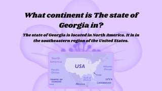
What continent isThe state of
Georgia in?
The state of Georgia is located in North America. It is in
the southeastern region of the United States.
3.
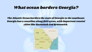
The Atlantic Oceanborders the state of Georgia to the southeast.
Georgia has a coastline along this ocean, with important coastal
cities like Savannah and Brunswick.
What ocean borders Georgia?
4.
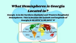
What Hemispheres isGeorgia
Located in?
Georgia is in the Northern (latitude) and Western (longitude)
Hemispheres. This is because the latitude and longitude of
Georgia is 32.1574° N, 82.9071° W
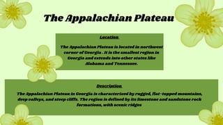
The Appalachian Plateau
TheAppalachian Plateau is located in northwest
corner of Georgia . It is the smallest region in
Georgia and extends into other states like
Alabama and Tennessee.
The Appalachian Plateau in Georgia is characterized by rugged, flat-topped mountains,
deep valleys, and steep cliffs. The region is defined by its limestone and sandstone rock
formations, with scenic ridges
Location
Description
7.
The Appalachian plateau(s2 )
Facts
climate Agriculture
Economic Contributions
The Appalachian plateau in
Georgia has a humid
subtropical climate with hot,
humid summers and mostly
mild winter.
The Appalachian plateau is
known for producing beef,
poultry, small grains,
tobacco, corn, apples,
tomatoes,and cabbage
-The Appalachian plateau is know as
the “TAG corner” because it connects
Tennesse, Alabama, and Georgia.
-The Appalachian plateau is so small that
it only has one county (Dade County)
The Appalachian plateau
contributed to Georgia’s economy
through mining and tourism, the
production of crops and livestock
also plays a big role
The Ridge andValley region can be located
southeast of the Appalachian plateau, but is also
in the northwestern corner of Georgia and is the
second smallest region in Georgia.
The physiographic features of this region
include: ridges, valleys, and excellent
agricultural land. The ridges are formed by
extensions of mountains located in the state.
The Ridge and Valley
Location
Description
10.
The Ridge andValley (s2 )
Facts
climate Agriculture
Economic Contributions
The Ridge and valley in has a
humid subtropical climate
with hot, humid summers and
mostly mild winter, with
moderate rainfall.
The Ridge and valley is
known for producing dairy
cattle, beef cattle, corn,
soybeans,cotto, and timber.
-This region is known as the “carpet
capital of the world”
-Before today’s technology, it was a
nearly unpassable barrier to European
settlers.
The Ridge and valley’s economic
contributions include textiles and
carpets, mining, and the crops that
this region produces.
The Blue Ridgeregion is located in the
northeastern corner of Georgia and is east of the
Ridge and Valley region. This region is the third
largest region in the state.
Named for the southern reach of the Appalachian
Mountain Range that stretches into the area, the
City of Blue Ridge boasts beautiful mountain views.
With key water features, such as Lake Blue Ridge
and the Toccoa River, Blue Ridge is the Trout
Fishing Capital of Georgia.
The Blue Ridge
Location
Description
13.
The Blue Region(s2 )
Facts
climate Agriculture
Economic Contributions
The Blue Ridge in has a humid
subtropical climate with hot, humid
summers and mostly mild winters,
and heavier rainfall than the other
regions in this state.
The Blue Ridge is known for
producing apples, peaches,
grapes, wine, beer, spirits,
tobacco and trout.
-Georgia's tallest mountain, Brasstown
Bald, is located here.
-The name “Blue Ridge” came from the
blue haze that appears when viewing
from a distance.
The Blue Ridge’s economic
contributions include the tourism,
automotive, mining, and fishing
industries
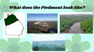
The Piedmont canbe located southeast of the
Valley and Ridge and northwest of the fall line
and coastal plain. This region is the second
largest region in the state.
The physiographic features of this region include:
rolling hills, shallow valleys, and red clay soil. A
unique feature of the area is the presence of
monadnocks, or granite rock outcrops, such as Stone
Mountain, Panola Mountain, and Arabia Mountain.
The Piedmont
Location
Description
16.
The Piedmont (s2)
Facts
climate Agriculture
Economic Contributions
The Ridge and valley in has a
humid subtropical climate
with hot, humid summers
and cool winters.
The Piedmont region is
known for producing
poultry, cotton, dairy, eggs,
and hog.
-Most populous region in Georgia due to
major cities like Atlanta and Athens.
-The Chattahoochee river runs through
this region.
The Piedmont’s economic
contributions includes: the tourism,
healthcare, aircraft, and automobile
manufacturing industries. As well as
the crops that this region produces.
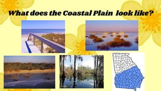
The Coastal plaincan be located southeast of the
Piedmont and fall line. And is the largest region in
the state.
The physiographic features of this region include:
generally low, flat, and swampy where it borders the
Atlantic, and grades to low rolling hills at the inner
margin.
The Coastal Plain
Location
Description
19.
The Costal Plain(s2 )
Facts
climate Agriculture
Economic Contributions
The Coastal in has a humid
subtropical climate with hot,
humid summers and cool
winters.
The Coastal plain region is known
for producing Vidalia onions,
peppers, peaches, blueberries,
pecans, watermelons, timber, and
peanuts
-Covers 60% of Georgia
-This region is home to some of the
oldest cities in Georgia like Savannah
and Brunswick.
The Coastal Plain’s economic
contributions includes: the tourism
and seafood seafood industries. As
well as the crops that this region
produces.
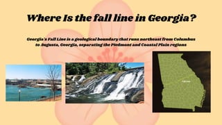
Where Is thefall line in Georgia?
Georgia's Fall Line is a geological boundary that runs northeast from Columbus
to Augusta, Georgia, separating the Piedmont and Coastal Plain regions
22.
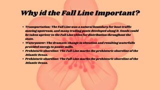
Why id theFall Line Important?
Transportation: The Fall Line was a natural boundary for boat traffic
moving upstream, and many trading posts developed along it. Goods could
be taken upriver to the Fall Line cities for distribution throughout the
state.
Waterpower: The dramatic change in elevation and resulting waterfalls
provided energy to power mills.
Prehistoric shoreline: The Fall Line marks the prehistoric shoreline of the
Atlantic Ocean.
Prehistoric shoreline: The Fall Line marks the prehistoric shoreline of the
Atlantic Ocean.
23.
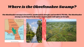
Where is theOkeefenokee Swamp?
The Okeefenokee swamp is located in southeastern Georgia and northern Florida. The Okeefenokee
swamp can be found In the lower coastal plain subregion in Georgia.
24.
Why is theOkeefenokee swamp
Important?
Wildlife Habitat: The Okefenokee Swamp is home to many species of wildlife, including threatened
and endangered species like the red-cockaded woodpecker, wood stork, and indigo snake. The swamp
is also home to a large population of American alligators.
Job opportunities: The Okefenokee hosts some 725,000 visitors annually who help create more than
750 local jobs and a total annual economic output of $64.7 million in the four counties surrounding
the swamp.
Tourism:The Okefenokee Swamp attracts millions of visitors each year, generating economic activity
and supporting jobs.
25.
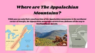
Where are TheAppalachian
Mountains?
While you can only find a small portion of the Appalachian mountains is the northwest
corner of Georgia, the Appalachian mountains stretch from Alabama all the way to
Newfoundland, Canada.
26.
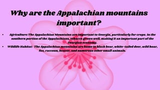
Why are theAppalachian mountains
important?
Agriculture:The Appalachian Mountains are important to Georgia, particularly for crops. In the
southern portion of the Appalachians, tobacco grows well, making it an important part of the
Georgian economy.
Wildlife Habitat: The AppalachIan mountains are home to black bear, white-tailed deer, wild boar,
fox, raccoon, beaver, and numerous other small animals.
27.
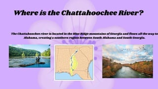
Where is theChattahoochee River?
The Chattahoochee river is located in the Blue Ridge mountains of Georgia and flows all the way to
Alabama, creating a southern region between South Alabama and South Georgia.
28.
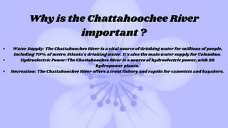
Why is theChattahoochee River
important ?
Water Supply: The Chattahoochee River is a vital source of drinking water for millions of people,
including 70% of metro Atlanta's drinking water. It's also the main water supply for Columbus.
Hydroelectric Power:The Chattahoochee River is a source of hydroelectric power, with 22
hydropower plants.
Recreation: The Chattahoochee River offers a trout fishery and rapids for canoeists and kayakers.
29.
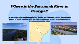
Where is theSavannah River in
Georgia?
The Savannah River can be found along the east border of Georgia and the southwest
border of South Carolina. This Border creates a natural state boundary between
Georgia and South Carolina.
30.
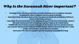
Why Is theSavannah River important?
Drinking Water:The Savannah River provides drinking water to millions of people,
including the cities of Augusta and Savannah in Georgia.
Hydroelectricity:The three dams on the river generate hundreds of millions of kilowatt
hours of electricity each year.
Exporting:The Savannah River is the shipping channel for the Port of Savannah, which is
the tenth-busiest port for oceangoing container ships in the United States.
Wildlife:The river is home to many endangered, threatened, and rare species of plants
and animals. The Savannah National Wildlife Refuge, which is located on the river's tidal
creeks, salt marshes, and freshwater marshes.
Recreation:The river is a popular spot for kayaking and paddle boarding.
31.
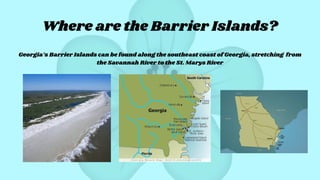
Where are theBarrier Islands?
Georgia’s Barrier Islands can be found along the southeast coast of Georgia, stretching from
the Savannah River to the St. Marys River
32.
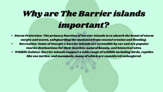
Why are TheBarrier islands
important?
Storm Protection: The primary function of barrier islands is to absorb the brunt of storm
surges and waves, safeguarding the mainland from coastal erosion and flooding.
Recreation: Some of Georgia's barrier islands are accessible by car and are popular
tourist destinations for their beaches, natural beauty, and historical sites.
Wildlife Habitat: Barrier islands support a wide range of wildlife including birds, reptiles
like sea turtles, and mammals, many of which are considered endangered.
33.
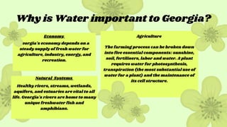
The farming processcan be broken down
into five essential components: sunshine,
soil, fertilizers, labor and water. A plant
requires water for photosynthesis,
transpiration (the most substantial use of
water for a plant) and the maintenance of
its cell structure.
Georgia's economy depends on a
steady supply of fresh water for
agriculture, industry, energy, and
recreation.
Healthy rivers, streams, wetlands,
aquifers, and estuaries are vital to all
life. Georgia's rivers are home to many
unique freshwater fish and
amphibians.
Why is Water important to Georgia?
Economy
Natural Systems
Agriculture
34.
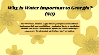
Our rivers arehome to large, diverse, unique communities of
freshwater fish and amphibians—including darters, sunfishes,
shiners and more. Communities depend on the availability of
clean water for drinking, agriculture and recreation.
Why is Water important to Georgia?
(S2)
35.
Name all 5of Georgia’s regions.
In which region are you most likely
to endure the most rainfal?
What River makes a border between south
Alabama and southe Georgia?
Blooms level Questions 1,2,3
Knowledge Application
Comprehension
36.
In which regionare you most likely
to find Vidailia onions being grown?
Out of all 5 regions of Georgia, which
region would NOT have tourism as
one of its main economic
contributions?
If there was a massive and destructive tropical
storm headed west towards Georgia from the
Atlantic Ocean, which of Georgia’s physical
features would be our only hope of survival?
Bloom’s level Questions 4,5,6
Synthesis
Evaluation
Analysis