Geoimaging the world online
•
0 likes•244 views

This document describes iOne Geoimaging's scalable sensor systems and intelligent automated processing workflow for collecting and analyzing geospatial imagery data from airborne, terrestrial, and mobile platforms. The workflow involves radiometric adjustment, interior and exterior orientation, feature extraction, and production of metric products such as orthophoto, DSM, point clouds, and classification outputs using an open systems software architecture and optional input DEM and raw imagery.

Recommended
Recommended
More Related Content
What's hot
What's hot (7)
Viewers also liked
Viewers also liked (6)
Similar to Geoimaging the world online
Similar to Geoimaging the world online (20)
More from Armando Guevara
More from Armando Guevara (18)
Geoimaging the world online
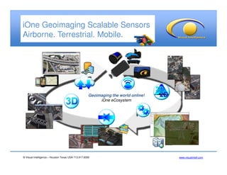
- 1. © Visual Intelligence – Houston Texas USA 713.917.8300 www.visualintell.com iOne Geoimaging Scalable Sensors Airborne. Terrestrial. Mobile. Geoimaging the world online! iOne eCosystem
- 2. © Visual Intelligence – Houston Texas USA 713.917.8300 www.visualintell.com iOne Sensors Intelligent Automated Processing Workflow Isis Earth Virtual Frames Ortho Oblique MS 4 Band DSM Stereo 3D Compilation Point Clouds - 3DM Natural Resources Classification Optional input DEM Optional input DEM Raw Imagery Open systems software architecture Project SetupProject Setup Radiometric Adjustment Radiometric Adjustment VF - ATVF - AT Interior & Exterior Orientation Interior & Exterior Orientation Feature ExtractionFeature Extraction Rigorous geometric and radiometric sensor calibration Rigorous geometric and radiometric sensor calibration Metric Products Metric Products Simactive Pix4D Dat/Em PCI