Digital Orthophotography Production
•
0 likes•159 views
LJT & Associates provides high-quality digital orthorectified aerial imagery products to government agencies for land management. They collect high-resolution natural color or infrared imagery using aircraft across the US. They offer orthoimage mosaics and digital stereo imagery products at various resolutions and formats for GIS and remote sensing use, with rapid response, quick turnaround, and no licensing restrictions.
Report
Share
Report
Share
Download to read offline
Recommended
The benefits of utility mapping 
After carefully collecting utility information using electromagnetic locating equipment, ground penetrating radar (GPR), and locating sondes, The Underground Detective can use the newest generation in mapping devices designed for Geographic Information System (GIS) to collect your valuable utility data.
Agilent technologies announces innovative image pipe for camera phones
Agilent Technologies announced a new image pipe processor that enables digital camera-like image quality for cell phone cameras. The image pipe contains over 10 enhancements including automatic lighting detection and advanced exposure control to produce sharp, vivid images even in low light. It is integrated into Agilent's new system-on-chip image sensors featuring enhanced-performance pixels. The tightly coupled design of the image pipe and sensor results in better color accuracy, contrast, and adaptive rendering compared to third-party graphics processors. The image pipe will be included in Agilent's new sensors in the first half of 2006 to address the increasing demand for higher quality pictures from mobile devices.
ERDAS IMAGINE
ERDAS IMAGINE is a remote sensing image processing software that allows users to import imagery from satellite and aerial platforms and extract useful geospatial information. It has three product tiers - Essentials, Advantage, and Professional - that scale in functionality. The software also includes additional specialized modules like Virtual GIS and Radar Mapping Suite. ERDAS IMAGINE enables tasks like land cover classification, camera placement, integration with Google Earth and Bing Maps, measurement of vertical features, map report generation, and flood modeling.
GloPos Positioning Technology
2013
“With the successful 3G tests,GloPos shows that the thousands of LBS apps, services and devices can be always on and used as originally intended.
This will radically improve the user experience and change the way how LBS services and companies interact with consumers”
-Mikael Vainio
Utility Mapping and Its Uses
Advanced Infrastructure Mapping (A.I.M.) is a Small, Veteran Owned, SWaM Certified Utility Mapping Company, based in Virginia Beach, Va. We have been in the Utility Locating business for 27+ years. We can provide Underground Utility Locating and Mapping services for clients such as Engineering Companies, Surveying Companies, Construction Companies, Municipalities, and as simple as a single homeowner.
70.mobile gis
Mobile GIS allows geographic information systems tools and data to be accessed on mobile devices through wireless networks. It has applications in fields like public safety, utilities management, and land surveying by enabling workers to view maps and collect geospatial data in the field. The key components of a mobile GIS include positioning systems, mobile GIS software, data synchronization capabilities, and geospatial data servers. A case study demonstrates how a university integrated a mobile GIS platform using ArcPad software on PocketPC devices to help campus security and emergency response teams respond quickly to incidents.
What is the need of Utility Mapping
Subsurface Utility Engineering (SUE) is a branch of Civil Engineering that involves managing certain risks associated with utility mapping at appropriate quality levels. The SUE process begins with a work plan that outlines the scope of work, project schedule, levels of service vs. risk allocation and desired delivery method.
Role of gis in telecommunications
This document describes how GIS was used to create the Telephone Exchange Information and Planning System (TEIPS) for the Vastrapur telephone exchange in Ahmedabad, India. TEIPS integrated spatial and non-spatial data on the telephone network into a GIS database to help with tasks like cable route planning, fault detection, and monitoring pillar utilization over time. The system allowed technicians to more efficiently plan and maintain the network.
Recommended
The benefits of utility mapping
After carefully collecting utility information using electromagnetic locating equipment, ground penetrating radar (GPR), and locating sondes, The Underground Detective can use the newest generation in mapping devices designed for Geographic Information System (GIS) to collect your valuable utility data.
Agilent technologies announces innovative image pipe for camera phones
Agilent Technologies announced a new image pipe processor that enables digital camera-like image quality for cell phone cameras. The image pipe contains over 10 enhancements including automatic lighting detection and advanced exposure control to produce sharp, vivid images even in low light. It is integrated into Agilent's new system-on-chip image sensors featuring enhanced-performance pixels. The tightly coupled design of the image pipe and sensor results in better color accuracy, contrast, and adaptive rendering compared to third-party graphics processors. The image pipe will be included in Agilent's new sensors in the first half of 2006 to address the increasing demand for higher quality pictures from mobile devices.
ERDAS IMAGINE
ERDAS IMAGINE is a remote sensing image processing software that allows users to import imagery from satellite and aerial platforms and extract useful geospatial information. It has three product tiers - Essentials, Advantage, and Professional - that scale in functionality. The software also includes additional specialized modules like Virtual GIS and Radar Mapping Suite. ERDAS IMAGINE enables tasks like land cover classification, camera placement, integration with Google Earth and Bing Maps, measurement of vertical features, map report generation, and flood modeling.
GloPos Positioning Technology
2013
“With the successful 3G tests,GloPos shows that the thousands of LBS apps, services and devices can be always on and used as originally intended.
This will radically improve the user experience and change the way how LBS services and companies interact with consumers”
-Mikael Vainio
Utility Mapping and Its Uses
Advanced Infrastructure Mapping (A.I.M.) is a Small, Veteran Owned, SWaM Certified Utility Mapping Company, based in Virginia Beach, Va. We have been in the Utility Locating business for 27+ years. We can provide Underground Utility Locating and Mapping services for clients such as Engineering Companies, Surveying Companies, Construction Companies, Municipalities, and as simple as a single homeowner.
70.mobile gis
Mobile GIS allows geographic information systems tools and data to be accessed on mobile devices through wireless networks. It has applications in fields like public safety, utilities management, and land surveying by enabling workers to view maps and collect geospatial data in the field. The key components of a mobile GIS include positioning systems, mobile GIS software, data synchronization capabilities, and geospatial data servers. A case study demonstrates how a university integrated a mobile GIS platform using ArcPad software on PocketPC devices to help campus security and emergency response teams respond quickly to incidents.
What is the need of Utility Mapping
Subsurface Utility Engineering (SUE) is a branch of Civil Engineering that involves managing certain risks associated with utility mapping at appropriate quality levels. The SUE process begins with a work plan that outlines the scope of work, project schedule, levels of service vs. risk allocation and desired delivery method.
Role of gis in telecommunications
This document describes how GIS was used to create the Telephone Exchange Information and Planning System (TEIPS) for the Vastrapur telephone exchange in Ahmedabad, India. TEIPS integrated spatial and non-spatial data on the telephone network into a GIS database to help with tasks like cable route planning, fault detection, and monitoring pillar utilization over time. The system allowed technicians to more efficiently plan and maintain the network.
Building Information Modeling
LJT & Associates is a veteran-owned engineering firm that provides services including BIM (Building Information Modeling) to various government clients. BIM involves creating an intelligent 3D model of a building that contains both graphical and non-graphical information to better understand the design. LJT is developing processes to create "As-Built BIM" models of existing structures using laser scanning and collects data to integrate BIM information into GIS systems. This allows different groups involved in development, maintenance and management to access building data and see returns on investment of 10-25% from properly implemented BIM systems.
Sociview press-release
Before your 'listen' map you Sociverse. SociView: The world's first social media-mapping application. Join us at http://bit.ly/mEi8KC
Shared services canada says it’s modernizing government, saving millions of d...
1) Shared Services Canada was launched in 2011 to modernize and consolidate the government's IT systems, saving millions by reducing duplication across departments.
2) SSC has already identified $50 million in savings over 3 years by switching to cheaper IP phones from traditional landlines.
3) SSC aims to reduce the government's 300 data centers, taking up 600,000 sq ft, to just 20 centers using one-third the space through increased efficiency and technology advances.
Анонс семинара 27 марта
Здравствуйте!
Компания Айбим, совместно с компаниями Synchro Ltd и «К4», проводит бесплатный открытый семинар «Новые реалии управления строительными проектами», который состоится в Москве 27 марта 2013 года.
Мы будем говорить о том, какие проблемы возникают у строителей в России и как с этими проблемами справиться. Анонс и программа семинара далее в презентации.
Мы рады пригласить Вас и Ваших коллег на первое мероприятие нашей компании в этом году. Будет интересно и полезно!
Регистрация на www.bim-info.com
Physical Security Consulting Services
LJT & Associates, Inc. provides physical security consulting services including risk analysis and vulnerability assessments, force protection engineering studies, entry control point studies, antiterrorism workshops, blast analysis studies, and security planning, training, and documentation. They have experience performing these services for federal clients and developing security methodologies, criteria, and training. LJT can access their services through various government contract vehicles as a certified small disadvantaged business.
Supplier Mentoring Program Checklist
The document provides a checklist mapping the requirements for an effective ethics and compliance program according to the Federal Sentencing Guidelines, Federal Acquisition Regulation, and Defense Industry Initiative. The checklist covers 16 key program elements including standards and procedures, board knowledge and oversight, due diligence, communication and training, monitoring and audits, reporting misconduct, enforcement, and response to issues. Adhering to the guidelines can help organizations prevent and detect criminal conduct and promote an ethical culture.
ABC_Supplier_CoC
The document summarizes the Supplier Code of Conduct of The Advisory Board Company. It outlines expectations for suppliers to act ethically, minimize environmental impacts, ensure safe and respectful workplaces, and respect the company's employees and property. The purpose is for suppliers to help the company achieve its mission of improving healthcare and education through responsible business conduct.
Inventory Mapping_r5a
Our solution provides total mapping and statistics solutions for plantations using unmanned aerial vehicles, GNSS, photogrammetry, and GIS. Key steps include acquiring high-resolution imagery via UAV, extracting geospatial data on plantation assets like roads and palm counts, and managing the data in a GIS database for uses like resource allocation, yield forecasting, and monitoring financial performance. The company offers UAV aerial survey packages for tasks like monitoring, general mapping, creating base maps, and topography extraction to support plantation management needs.
Aerial Services, Inc
Aerial Services, Inc. (ASI) is an integrated team of professionals providing premier services and products to government, utilities, engineers, and other geospatial customers. Based in the Iowa heartland for over 40 years, Aerial Services’ Midwestern work ethic, cutting-edge technology, and experienced staff combine to harness the power of geographic information and provide solutions you need.
F3D Corporate Snapshot V3.1 - Generic GP
Fastree3D is developing affordable 3D vision technology using direct time-of-flight measurement that can help automotive and robotics applications. Their technology offers 10x better price/performance than existing solutions and could help avoid 50,000 annual road fatalities if installed in vehicles. Fastree3D aims to enable more widespread use of safety and driver assistance applications through their lower-cost 3D cameras with high performance.
Rolta Geomatica Suite
Rolta Geomatica Suite is a single integrated software system, which brings highest degree of automation for Remote Sensing and Image Processing and turns imagery into answers and offers robust solutions for all types of desktop Geomatics. It helps in various GIS based workflow applications and advanced image analysis such as change detection. The software brings patented algorithms for image classification, cartographic map production, hyper-spectral analysis, advanced Data visualization and editing and raster spatial analysis.
Geospatial services
SBL offers a comprehensive range of Geospatial services that address the varied needs of consumers, businesses, and government agencies.
GPS Assisted Roadmapping and Vehicle Monitoring
It was my final year engineering project.
Keywords : Arduino Uno, GPS, GSM, Accelerometer, MATLAB, SMS alert
Tackling "BIG Data": Mobile LiDAR Transportation Project Use Case
2015 International LiDAR Mapping Forum (ILMF) conference presentation by Josh Beck, Senior Software Consultant for Merrick & Company's Geomatics team. Presentation occurred on Tuesday, February 24, 2015 at the Hyatt Regency Denver at Colorado Convention Center in Denver, Colorado.
ANTI-VEHICLE TRACKING SYSTEM USING SMARTPHONE APPLICATION
This document describes the design of a vehicle tracking system using GPS and GSM technologies along with a smartphone application. The system has two main units - a vehicle unit that tracks the vehicle's location using a GPS module and transmits it via GSM/GPRS to a remote server, and a monitoring unit where the user can track the vehicle on a smartphone application. The system aims to provide security for parked vehicles and allow users to locate a stolen vehicle. It was designed using an Arduino microcontroller, GPS and GSM modules, and can find various applications like fleet management and monitoring drivers.
Worknet smart pole overview
SmartCiti Solutions provides smart pole technology that collects data using sensors and cameras for applications like traffic monitoring and public WiFi. Their poles can be customized to match urban environments. The poles conceal antennas, cameras, and other equipment and use artificial intelligence for tasks like vehicle detection and traffic analytics. Their solution integrates data collection, optimization, and presentation capabilities to help cities make decisions based on pole-gathered information.
Brosure Laser 4D Monitoring Systems 3DLM UK Jogja
3D Laser Mapping provides laser scanning solutions including terrestrial, airborne, and mobile laser scanning. Their systems use advanced laser scanning technology and software to rapidly capture high-resolution 3D data with sub-10mm accuracy. Applications include highways, urban mapping, waterways, forestry, overhead lines, city modeling, and more. They integrate RIEGL laser scanners with 3DLM software to create robust surveying systems and offer solutions for monitoring, mapping, and mining applications around the world.
GeoCollector for ArcPad
GeoCollector for ArcPad is a mobile GIS solution that combines Esri's ArcPad software with Trimble GPS hardware to improve the accuracy of collected location data. It provides field workers with a rugged tablet equipped with an integrated GPS receiver and ArcPad software for mapping and data collection. This solution allows organizations to make timely decisions based on reliable location information gathered by field staff.
High-Quality Geodata for High-Accuracy Modeling | Datasheet | Infovista
Infovista develops digital mapping products for the telecom sector to provide accurate models for wireless network planning and optimization. Their geodata portfolio includes a range of mapping products at different levels of detail and resolution to meet the needs of network operators and support accurate radio frequency modeling. With an extensive inventory of high quality mapping data, Infovista is well-positioned to help customers plan for technologies like 5G that require very accurate models to account for factors such as millimeter wave frequencies and dense network deployment.
GWT 2014: Emergency Conference - 02 le soluzioni geospaziali per la gestione ...
Geospatial World Tour 2014: Emergency Conference.
Napoli, 28 maggio 2014.
Le soluzioni Geospaziali per la gestione delle emergenze.
Simone Colla, Hexagon Geospatial
GEOMETER INTERNATIONAL PRESENTS HIGH PRECISION POSITIONING RTK TECHNOLOGY
Geometer International offers its own developments for high-precision navigation and positioning.
The essence of the RTK GNSS method is to receive a satellite signal simultaneously by a mobile rover at a point and a base station at a known static point.
The database records the difference between calculated and actual data and transmits the RTK correction to the rover. This technology allows to achieve absolute positioning accuracy at the level of 1 cm.
RVS_Catalog01.2015
This document summarizes Radiant Vision Systems' portfolio of light and color measurement products including imaging colorimeters, photometers, and automated visual inspection software. The company offers solutions for applications such as flat panel display testing, lighting characterization, and high-volume manufacturing production line testing. Key products highlighted include the ProMetric line of imaging colorimeters and photometers and the TrueTest software for automated visual inspection.
More Related Content
Viewers also liked
Building Information Modeling
LJT & Associates is a veteran-owned engineering firm that provides services including BIM (Building Information Modeling) to various government clients. BIM involves creating an intelligent 3D model of a building that contains both graphical and non-graphical information to better understand the design. LJT is developing processes to create "As-Built BIM" models of existing structures using laser scanning and collects data to integrate BIM information into GIS systems. This allows different groups involved in development, maintenance and management to access building data and see returns on investment of 10-25% from properly implemented BIM systems.
Sociview press-release
Before your 'listen' map you Sociverse. SociView: The world's first social media-mapping application. Join us at http://bit.ly/mEi8KC
Shared services canada says it’s modernizing government, saving millions of d...
1) Shared Services Canada was launched in 2011 to modernize and consolidate the government's IT systems, saving millions by reducing duplication across departments.
2) SSC has already identified $50 million in savings over 3 years by switching to cheaper IP phones from traditional landlines.
3) SSC aims to reduce the government's 300 data centers, taking up 600,000 sq ft, to just 20 centers using one-third the space through increased efficiency and technology advances.
Анонс семинара 27 марта
Здравствуйте!
Компания Айбим, совместно с компаниями Synchro Ltd и «К4», проводит бесплатный открытый семинар «Новые реалии управления строительными проектами», который состоится в Москве 27 марта 2013 года.
Мы будем говорить о том, какие проблемы возникают у строителей в России и как с этими проблемами справиться. Анонс и программа семинара далее в презентации.
Мы рады пригласить Вас и Ваших коллег на первое мероприятие нашей компании в этом году. Будет интересно и полезно!
Регистрация на www.bim-info.com
Physical Security Consulting Services
LJT & Associates, Inc. provides physical security consulting services including risk analysis and vulnerability assessments, force protection engineering studies, entry control point studies, antiterrorism workshops, blast analysis studies, and security planning, training, and documentation. They have experience performing these services for federal clients and developing security methodologies, criteria, and training. LJT can access their services through various government contract vehicles as a certified small disadvantaged business.
Supplier Mentoring Program Checklist
The document provides a checklist mapping the requirements for an effective ethics and compliance program according to the Federal Sentencing Guidelines, Federal Acquisition Regulation, and Defense Industry Initiative. The checklist covers 16 key program elements including standards and procedures, board knowledge and oversight, due diligence, communication and training, monitoring and audits, reporting misconduct, enforcement, and response to issues. Adhering to the guidelines can help organizations prevent and detect criminal conduct and promote an ethical culture.
ABC_Supplier_CoC
The document summarizes the Supplier Code of Conduct of The Advisory Board Company. It outlines expectations for suppliers to act ethically, minimize environmental impacts, ensure safe and respectful workplaces, and respect the company's employees and property. The purpose is for suppliers to help the company achieve its mission of improving healthcare and education through responsible business conduct.
Viewers also liked (7)
Shared services canada says it’s modernizing government, saving millions of d...
Shared services canada says it’s modernizing government, saving millions of d...
Similar to Digital Orthophotography Production
Inventory Mapping_r5a
Our solution provides total mapping and statistics solutions for plantations using unmanned aerial vehicles, GNSS, photogrammetry, and GIS. Key steps include acquiring high-resolution imagery via UAV, extracting geospatial data on plantation assets like roads and palm counts, and managing the data in a GIS database for uses like resource allocation, yield forecasting, and monitoring financial performance. The company offers UAV aerial survey packages for tasks like monitoring, general mapping, creating base maps, and topography extraction to support plantation management needs.
Aerial Services, Inc
Aerial Services, Inc. (ASI) is an integrated team of professionals providing premier services and products to government, utilities, engineers, and other geospatial customers. Based in the Iowa heartland for over 40 years, Aerial Services’ Midwestern work ethic, cutting-edge technology, and experienced staff combine to harness the power of geographic information and provide solutions you need.
F3D Corporate Snapshot V3.1 - Generic GP
Fastree3D is developing affordable 3D vision technology using direct time-of-flight measurement that can help automotive and robotics applications. Their technology offers 10x better price/performance than existing solutions and could help avoid 50,000 annual road fatalities if installed in vehicles. Fastree3D aims to enable more widespread use of safety and driver assistance applications through their lower-cost 3D cameras with high performance.
Rolta Geomatica Suite
Rolta Geomatica Suite is a single integrated software system, which brings highest degree of automation for Remote Sensing and Image Processing and turns imagery into answers and offers robust solutions for all types of desktop Geomatics. It helps in various GIS based workflow applications and advanced image analysis such as change detection. The software brings patented algorithms for image classification, cartographic map production, hyper-spectral analysis, advanced Data visualization and editing and raster spatial analysis.
Geospatial services
SBL offers a comprehensive range of Geospatial services that address the varied needs of consumers, businesses, and government agencies.
GPS Assisted Roadmapping and Vehicle Monitoring
It was my final year engineering project.
Keywords : Arduino Uno, GPS, GSM, Accelerometer, MATLAB, SMS alert
Tackling "BIG Data": Mobile LiDAR Transportation Project Use Case
2015 International LiDAR Mapping Forum (ILMF) conference presentation by Josh Beck, Senior Software Consultant for Merrick & Company's Geomatics team. Presentation occurred on Tuesday, February 24, 2015 at the Hyatt Regency Denver at Colorado Convention Center in Denver, Colorado.
ANTI-VEHICLE TRACKING SYSTEM USING SMARTPHONE APPLICATION
This document describes the design of a vehicle tracking system using GPS and GSM technologies along with a smartphone application. The system has two main units - a vehicle unit that tracks the vehicle's location using a GPS module and transmits it via GSM/GPRS to a remote server, and a monitoring unit where the user can track the vehicle on a smartphone application. The system aims to provide security for parked vehicles and allow users to locate a stolen vehicle. It was designed using an Arduino microcontroller, GPS and GSM modules, and can find various applications like fleet management and monitoring drivers.
Worknet smart pole overview
SmartCiti Solutions provides smart pole technology that collects data using sensors and cameras for applications like traffic monitoring and public WiFi. Their poles can be customized to match urban environments. The poles conceal antennas, cameras, and other equipment and use artificial intelligence for tasks like vehicle detection and traffic analytics. Their solution integrates data collection, optimization, and presentation capabilities to help cities make decisions based on pole-gathered information.
Brosure Laser 4D Monitoring Systems 3DLM UK Jogja
3D Laser Mapping provides laser scanning solutions including terrestrial, airborne, and mobile laser scanning. Their systems use advanced laser scanning technology and software to rapidly capture high-resolution 3D data with sub-10mm accuracy. Applications include highways, urban mapping, waterways, forestry, overhead lines, city modeling, and more. They integrate RIEGL laser scanners with 3DLM software to create robust surveying systems and offer solutions for monitoring, mapping, and mining applications around the world.
GeoCollector for ArcPad
GeoCollector for ArcPad is a mobile GIS solution that combines Esri's ArcPad software with Trimble GPS hardware to improve the accuracy of collected location data. It provides field workers with a rugged tablet equipped with an integrated GPS receiver and ArcPad software for mapping and data collection. This solution allows organizations to make timely decisions based on reliable location information gathered by field staff.
High-Quality Geodata for High-Accuracy Modeling | Datasheet | Infovista
Infovista develops digital mapping products for the telecom sector to provide accurate models for wireless network planning and optimization. Their geodata portfolio includes a range of mapping products at different levels of detail and resolution to meet the needs of network operators and support accurate radio frequency modeling. With an extensive inventory of high quality mapping data, Infovista is well-positioned to help customers plan for technologies like 5G that require very accurate models to account for factors such as millimeter wave frequencies and dense network deployment.
GWT 2014: Emergency Conference - 02 le soluzioni geospaziali per la gestione ...
Geospatial World Tour 2014: Emergency Conference.
Napoli, 28 maggio 2014.
Le soluzioni Geospaziali per la gestione delle emergenze.
Simone Colla, Hexagon Geospatial
GEOMETER INTERNATIONAL PRESENTS HIGH PRECISION POSITIONING RTK TECHNOLOGY
Geometer International offers its own developments for high-precision navigation and positioning.
The essence of the RTK GNSS method is to receive a satellite signal simultaneously by a mobile rover at a point and a base station at a known static point.
The database records the difference between calculated and actual data and transmits the RTK correction to the rover. This technology allows to achieve absolute positioning accuracy at the level of 1 cm.
RVS_Catalog01.2015
This document summarizes Radiant Vision Systems' portfolio of light and color measurement products including imaging colorimeters, photometers, and automated visual inspection software. The company offers solutions for applications such as flat panel display testing, lighting characterization, and high-volume manufacturing production line testing. Key products highlighted include the ProMetric line of imaging colorimeters and photometers and the TrueTest software for automated visual inspection.
Rolta Photogrammetry Suite
Rolta Photogrammetry suite is an end to end photogrammetry solution providing a versatile collection of software tools to produce reliable geospatial data sets with the highest accuracy. The modular configuration of this program makes it an easy to use, accurate and cost-effective in a production oriented environment. It addresses the entire range of photogrammetric techniques along with added imaging applications to produce quality geospatial products. The products are technically supported by experienced domain experts.
Prayas session cgi & cga by – soumalya nandy
Computer graphics is responsible for displaying art and image data effectively and beautifully to the user, and processing image data received from the physical world. The interaction and understanding of computers and interpretation of data has been made easier because of computer graphics. It have had a profound impact on many types of media and have revolutionized animation, movies and the video game industry.
Computer-generated imagery (CGI) is the application of computer graphics to create or contribute to images in art, printed media, video games, films, television programs, commercials, videos, and simulators. The visual scenes may be dynamic or static, and may be two-dimensional (2D), though the term "CGI" is most commonly used to refer to 3D computer graphics used for creating scenes or special effects in films and television.
Video games most often use real-time computer graphics (rarely referred to as CGI), but may also include pre-rendered "cut scenes" and intro movies that would be typical CGI applications.
VIMOC SMART CITY INFRASTRUCTURE Parking Management Solution
The VIMOC Landscape-Computing wireless vehicle parking detection and management system. Open source HW,
A review on automatic wavelet based nonlinear image enhancement for aerial ...
This document summarizes an article from the International Journal of Electronics and Communication Engineering & Technology about improving aerial imagery through automatic wavelet-based nonlinear image enhancement. It discusses how aerial images often have low clarity due to atmospheric effects and limited dynamic range of cameras. The proposed method uses wavelet-based dynamic range compression to enhance aerial images while preserving local contrast and tonal rendition. It applies techniques like nonlinear processing, selective enhancement based on the human visual system, and uses Gabor filters for high-pass filtering to generate a enhanced image. The results of applying this algorithm to various aerial images show strong robustness and improved image quality.
Image Processing Training in Chandigarh
Here in E2MATRIX , We provide the best coaching & training and IEEE projects. We provide professional courses like matlab, image processing, cloud computing,Android, electrical domain .NET, JAVA, WEKA, NS-2, MATLAB SIMULINK, and our main emphasis is thesis for MTECH , research projects, IEEE projects. Provide Research Help to all Engineering classes in all the fields of electrical , electronics, IT and Computers.
Contact us at:
E2MATRIX
Opp. Bus Stand, Parmar Complex,
Backside Axis Bank, Phagwara - Punjab (INDIA).
Contact: +91 9041262727, 9779363902,
Web: www.e2matrix.com
Similar to Digital Orthophotography Production (20)
Tackling "BIG Data": Mobile LiDAR Transportation Project Use Case
Tackling "BIG Data": Mobile LiDAR Transportation Project Use Case
ANTI-VEHICLE TRACKING SYSTEM USING SMARTPHONE APPLICATION
ANTI-VEHICLE TRACKING SYSTEM USING SMARTPHONE APPLICATION
High-Quality Geodata for High-Accuracy Modeling | Datasheet | Infovista
High-Quality Geodata for High-Accuracy Modeling | Datasheet | Infovista
GWT 2014: Emergency Conference - 02 le soluzioni geospaziali per la gestione ...
GWT 2014: Emergency Conference - 02 le soluzioni geospaziali per la gestione ...
GEOMETER INTERNATIONAL PRESENTS HIGH PRECISION POSITIONING RTK TECHNOLOGY
GEOMETER INTERNATIONAL PRESENTS HIGH PRECISION POSITIONING RTK TECHNOLOGY
VIMOC SMART CITY INFRASTRUCTURE Parking Management Solution
VIMOC SMART CITY INFRASTRUCTURE Parking Management Solution
A review on automatic wavelet based nonlinear image enhancement for aerial ...
A review on automatic wavelet based nonlinear image enhancement for aerial ...
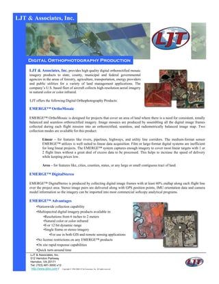
Digital Orthophotography Production
- 1. LJT & Associates, Inc. Digital Orthophotography Production LJT & Associates, Inc. provides high quality digital orthorectified mosaic imagery products to state, county, municipal and federal governmental agencies in the areas of forestry, agriculture, transportation, energy providers and public utilities for a variety of land management applications. The company’s U.S. based fleet of aircraft collects high-resolution aerial imagery in natural color or color infrared. LJT offers the following Digital Orthophotography Products: EMERGE™ OrthoMosaic EMERGE™ OrthoMosaic is designed for projects that cover an area of land where there is a need for consistent, tonally balanced and seamless orthorectified imagery. Image mosaics are produced by assembling all the digital image frames collected during each flight mission into an orthorectified, seamless, and radiometrically balanced image map. Two collection modes are available for this product: Linear – for features like rivers, pipelines, highways, and utility line corridors. The medium-format sensor EMERGE™ utilizes is well suited to linear data acquisition. Film or large-format digital systems are inefficient for long linear projects. The EMERGE™ system captures enough imagery to cover most linear targets with 1 or 2 flight lines without a great deal of excess data to be processed. This helps to increase the speed of delivery while keeping prices low. Area – for features like, cities, counties, states, or any large or small contiguous tract of land. EMERGE™ DigitalStereo EMERGE™ DigitalStereo is produced by collecting digital image frames with at least 60% endlap along each flight line over the project area. Stereo image pairs are delivered along with GPS position points, IMU orientation data and camera model information so the imagery can be imported into most commercial softcopy analytical programs. EMERGE™ Advantages •Nationwide collection capability •Multispectral digital imagery products available in: •Resolutions from 6 inches to 2 meters •Natural color or color infrared •8 or 12 bit dynamic range •Single frame or stereo imagery •For use in both GIS and remote sensing applications •No license restrictions on any EMERGE™ products •On site rapid response capabilities •Quick turn-around time LJT & Associates, Inc. 512 Herndon Parkway Herndon, VA 20171 Tel: (703) 481-3000 x12 http://www.ljtinc.com / Copyright © 1994-2006 LJT & Associates, Inc. All rights reserved.