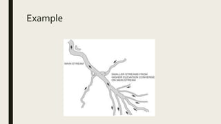
GEOGRAPHY
Lesson plan
Who?
■ Mr X will be conducting a lesson with a class of Grade 12A learners who are 32 in class,
12 boys and 20 girls.The educator’s strong points are listening to the learners, audible,
motivational and positive. His week points are time management and attention
seeking.
■ The learners from Grade 12A are around the ages of 17-19 years, they are mixed in
gender.They all fall under the African race but come from different tribal groups.They
are not fluent with the language of English and thus it will be a challenge in it (English)
being a language for learning and teaching. Some learners within the class are from
poor economic backgrounds, this can strain some experiments the educator might
want to do with the learners.
What?
■ Fluvial Processes
■ Strata influencing the type of drainage pattern
■ Relating to map-work
When?
■ WEDNESDAY 5TH PERIOD 12:30
Where?
■ Horizon Park High School
What for?
■ At the end of the lesson, learners should be able to :
– Identify the different forms of drainage patterns
– List differences that each pattern has in contrast to the other
– Identify the landforms that determine the drainage pattern
– Appreciate the role of natural phenomena and landforms in sourcing water to
different areas
– Use a map and different symbols on the map to identify the different landforms and
resulting drainage
– Apply their skills in fieldwork or related experiences
How?
■ Invitation: Pictionary- Introduce or remind learners of terminology that is going to be
adopted in the content
■ Engaging with new content: lecture, question and answering, demonstrations and
scenarios
■ Summary and integration: problem based method
Intro-Terminology related with topic
■ Interfluve
■ Water-table
■ Permeable rock
■ Impermeable rock
■ Base flow
■ Through flow
■ Aquifer
■ Artesian basin
■ Confluence
■ Tributaries
■ Distributaries
■ River rises
■ River mouth
Example
Engage
■ Use the lecture method to teach the content that learners are not well acquainted
with as observed on the Pictionary game
■ Use the ideas learners have to scaffold new information
■ Ask questions to identify challenges learners might be experiencing in grasping new
content
■ Use pictures to further enhance the grasping of content
■ Use a map/atlas to allow learners to engage whilst demonstrating how to apply map
skills to determine concepts that are taught
Summary and integration
■ Provide learners with the activities that challenge their application of what they have
learned and facilitate progress on the activity
■ Reflect with learners on the objectives to determine if they were met
Big Ideas of the lesson
■ Connection of fluvial geomorphology and landform geomorphology
■ The application of content knowledge to skills and real life situations
■ Effects of landforms on water supply

Geography Lesson Planning

  • 1.
  • 2.
    Who? ■ Mr Xwill be conducting a lesson with a class of Grade 12A learners who are 32 in class, 12 boys and 20 girls.The educator’s strong points are listening to the learners, audible, motivational and positive. His week points are time management and attention seeking. ■ The learners from Grade 12A are around the ages of 17-19 years, they are mixed in gender.They all fall under the African race but come from different tribal groups.They are not fluent with the language of English and thus it will be a challenge in it (English) being a language for learning and teaching. Some learners within the class are from poor economic backgrounds, this can strain some experiments the educator might want to do with the learners.
  • 3.
    What? ■ Fluvial Processes ■Strata influencing the type of drainage pattern ■ Relating to map-work
  • 4.
  • 5.
  • 6.
    What for? ■ Atthe end of the lesson, learners should be able to : – Identify the different forms of drainage patterns – List differences that each pattern has in contrast to the other – Identify the landforms that determine the drainage pattern – Appreciate the role of natural phenomena and landforms in sourcing water to different areas – Use a map and different symbols on the map to identify the different landforms and resulting drainage – Apply their skills in fieldwork or related experiences
  • 7.
    How? ■ Invitation: Pictionary-Introduce or remind learners of terminology that is going to be adopted in the content ■ Engaging with new content: lecture, question and answering, demonstrations and scenarios ■ Summary and integration: problem based method
  • 8.
    Intro-Terminology related withtopic ■ Interfluve ■ Water-table ■ Permeable rock ■ Impermeable rock ■ Base flow ■ Through flow ■ Aquifer ■ Artesian basin ■ Confluence ■ Tributaries ■ Distributaries ■ River rises ■ River mouth
  • 9.
  • 10.
    Engage ■ Use thelecture method to teach the content that learners are not well acquainted with as observed on the Pictionary game ■ Use the ideas learners have to scaffold new information ■ Ask questions to identify challenges learners might be experiencing in grasping new content ■ Use pictures to further enhance the grasping of content ■ Use a map/atlas to allow learners to engage whilst demonstrating how to apply map skills to determine concepts that are taught
  • 11.
    Summary and integration ■Provide learners with the activities that challenge their application of what they have learned and facilitate progress on the activity ■ Reflect with learners on the objectives to determine if they were met
  • 12.
    Big Ideas ofthe lesson ■ Connection of fluvial geomorphology and landform geomorphology ■ The application of content knowledge to skills and real life situations ■ Effects of landforms on water supply