Downloaded 62 times

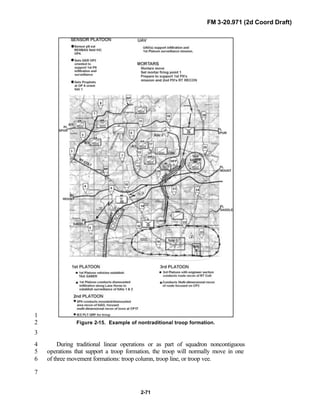
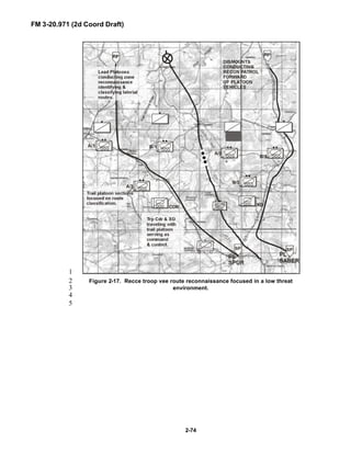
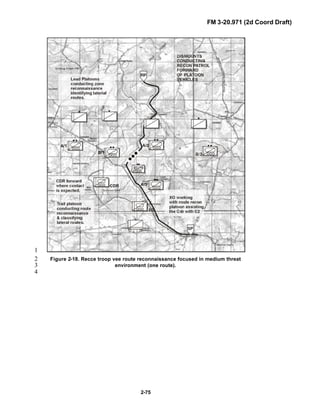
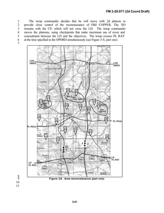
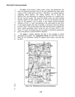
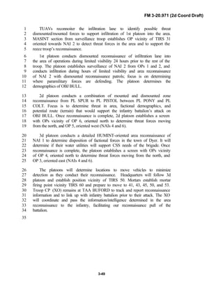
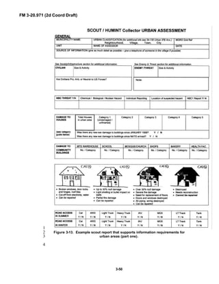
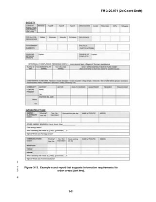
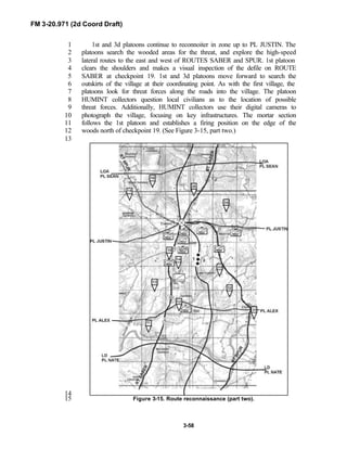
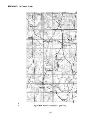
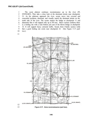
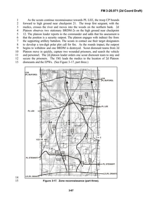
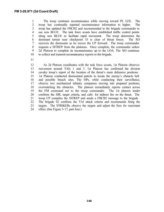
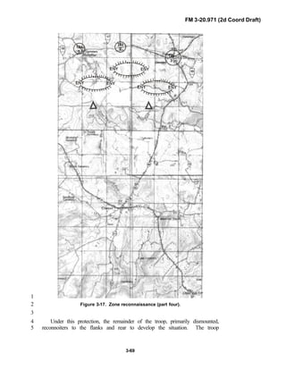
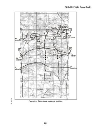
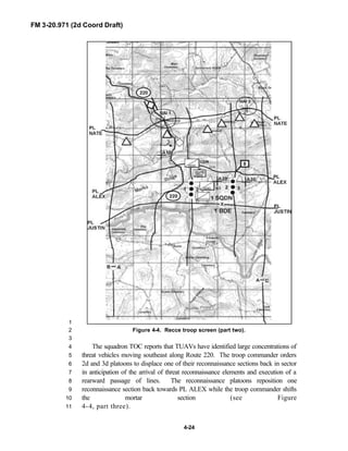
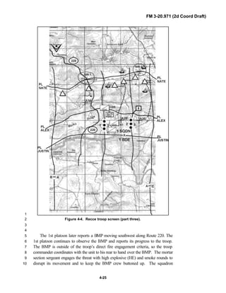
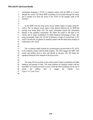
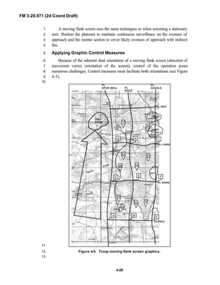
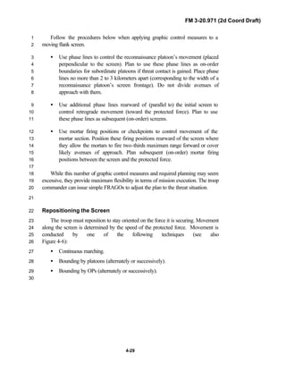
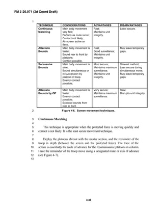
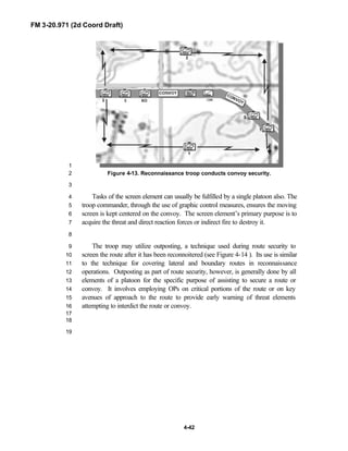
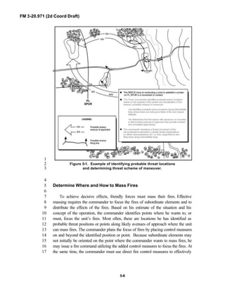
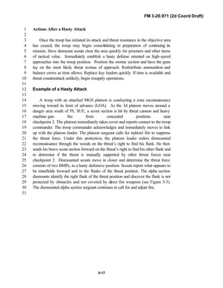
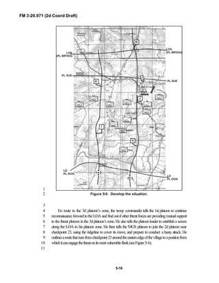
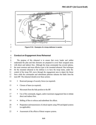
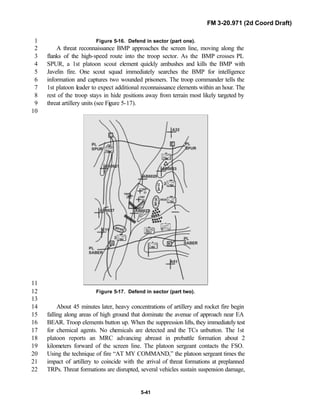
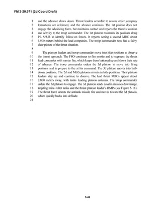
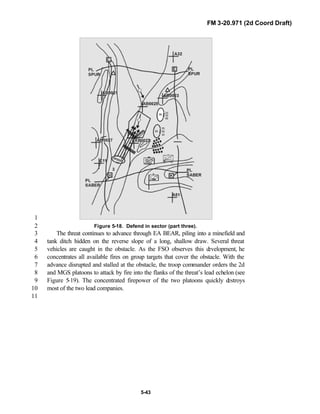
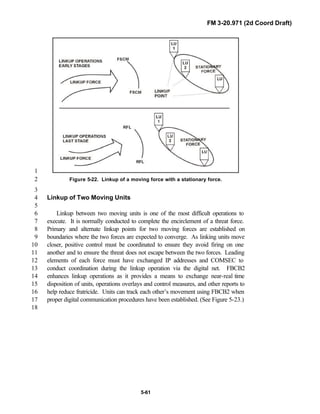
![FM 3-20.971 (2d Coord Draft)
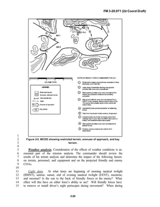
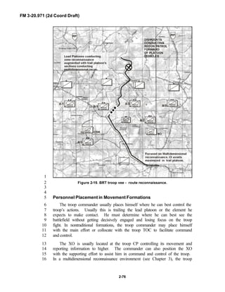
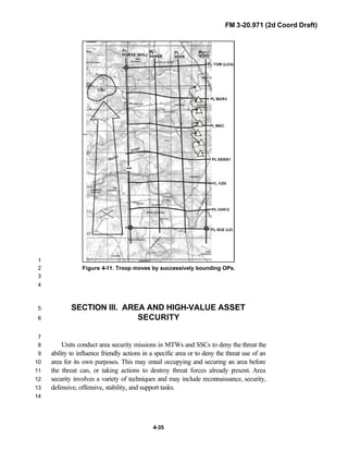
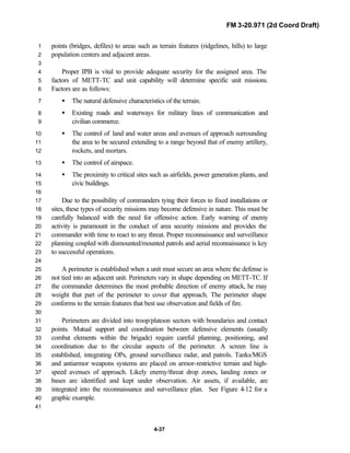
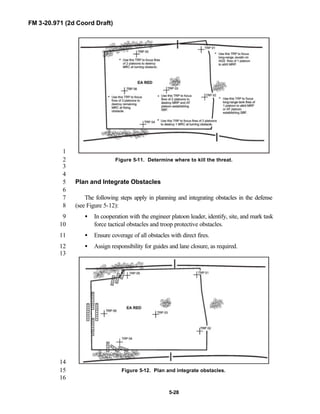
iii
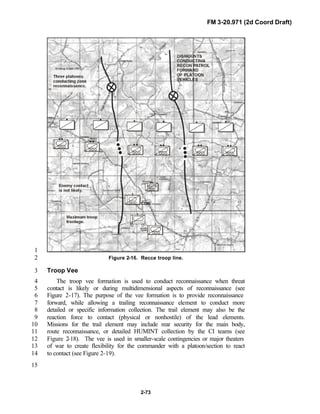
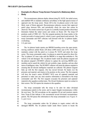
PREFACE1
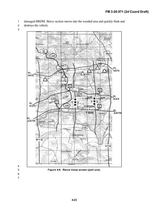
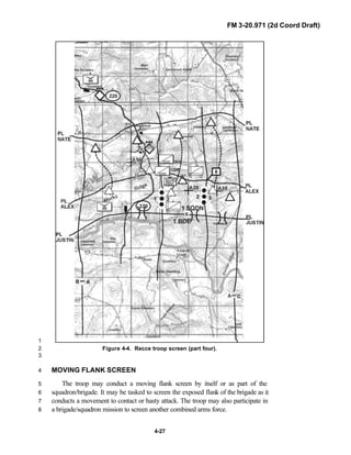
2
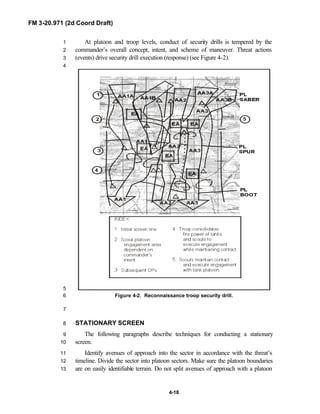
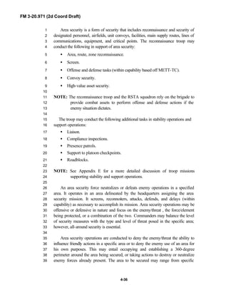
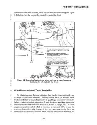
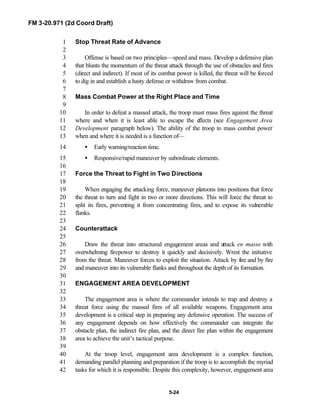
3
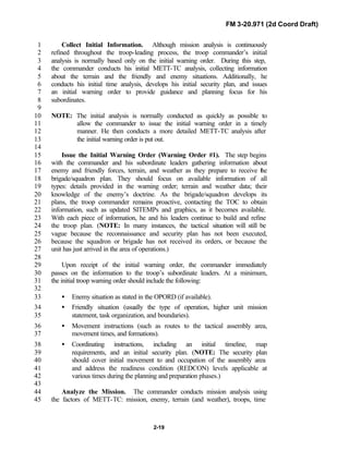
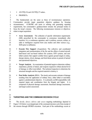
FM 3-20.971 describes the tactical employment and operations of4
reconnaissance troops of armored and mechanized infantry brigades (BRTs)5
and the recce troops of the Reconnaissance Surveillance and Target6
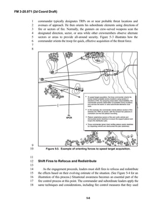
Acquisition (RSTA) squadrons. It specifically addresses operations for7
brigades organized under the Army of Excellence, the Limited Conversion8
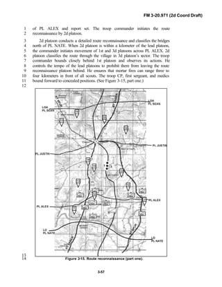
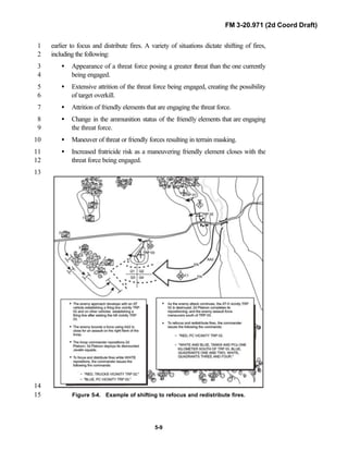
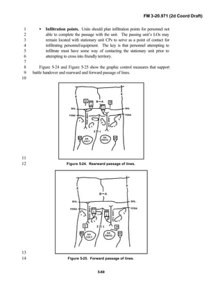
Division force designs, and the Interim Brigade Combat Team (IBCT). FM 3-9
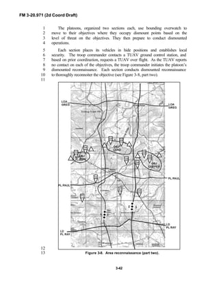
20.971 is the doctrinal foundation that governs the development of equipment,10
training, and structure for both types of reconnaissance troops.11
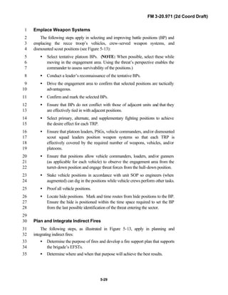
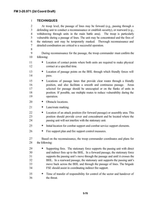
12
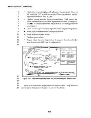
Because not all units are digitally equipped, this manual addresses analog13
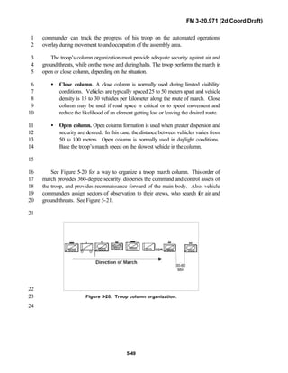
and digital operations, technology applications, and equipment. Tactical14
fundamentals do not change with the fielding of new equipment; however, the15
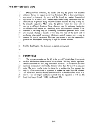
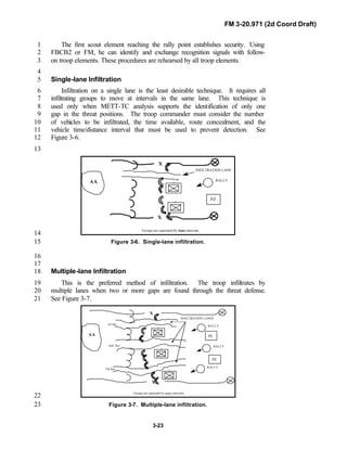
integration of new equipment and organizations may require changes in16
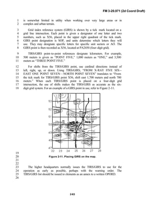
related techniques and procedures. This manual provides guidance in the17
form of combat-tested concepts and ideas modified to exploit emerging Army18
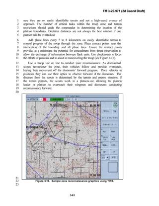
and Joint capabilities.19
20
FM 3-20.971 is written for the recon troop commander and his key leaders21
within the troop. The manual reflects and supports the Army operations22
doctrine as stated in FM 3-0. Readers should be familiar with FM 3-91.3 [FM23
71-3], FM 3-20-97 [FM 17-97], FM 3-100.40 [FM 100-40], FM 3-71 [FM 71-24
100], FM 3-55 [FM 100-55], FM 102 [FM 101-5-1], and FM 3-20.98 [FM 17-25
98]. Examples and graphics are provided to illustrate principles and concepts,26
not to serve as prescriptive responses to tactical situations. This publication27
provides units with the doctrinal foundation to train leaders, guide tactical28
planning, and develop standing operating procedures (SOP). The publication29
applies to all reconnaissance troops in the active component (AC) and reserve30
component (NG/RC) force.31
32
Unless otherwise stated, masculine nouns and pronouns do not refer33
exclusively to men.34
35
US Army Armor Center is the proponent for this publication. Submit36
comments and recommended changes and the rational for those changes on37
DA Form 2028 (Recommended Changes to Publications and Blank Forms) to:38
Commander, US Army Armor Center, ATTN: ATZK-TDD-C, Fort Knox, KY39
40121-5000, or e-mail the DA Form 2028 to Chief, Cavalry Branch, from the40
Doctrine Division web site at41
http://147.238.100.101/center/dtdd/doctrine/armordoc.htm. (After accessing42
the web site, select “Organization” from the menu on the left side of the43
screen to reach the Cavalry Branch site.)44
45](https://image.slidesharecdn.com/fm-3-20-140723131053-phpapp02/85/Fm-3-20-97-the-recce_and_brt_troop_draft-4-320.jpg)
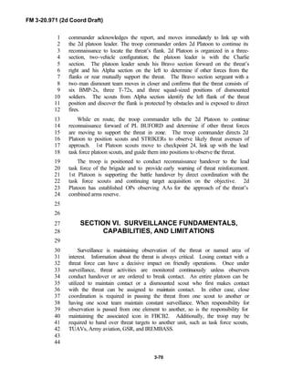
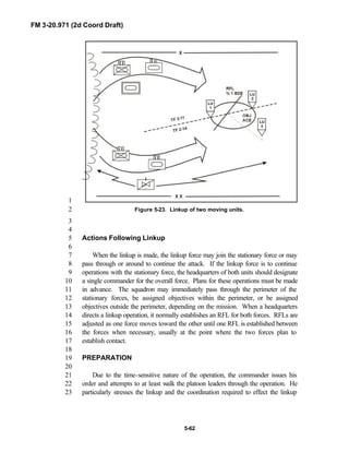
![FM 3-20.971 (2d Coord Draft)
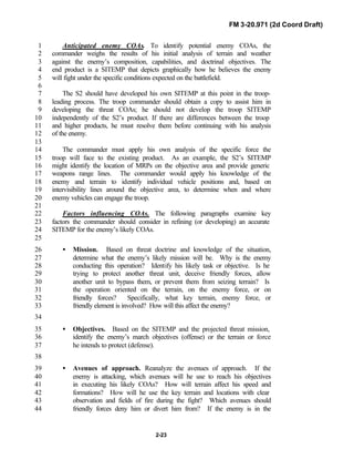
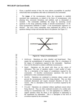
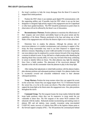
1-13
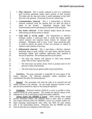
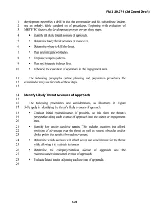
Information superiority is a
significant information advantage
gained by collecting, processing, and
disseminating an uninterrupted flow
of relevant information in support of
military operations while exploiting or
denying a threat or adversary the
ability to do the same.
1
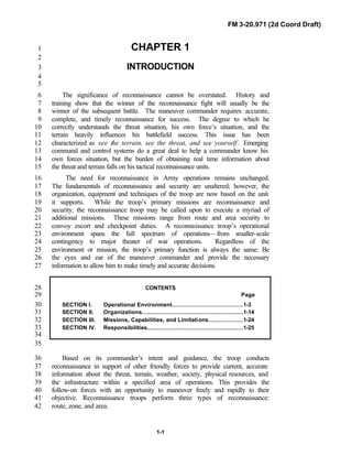
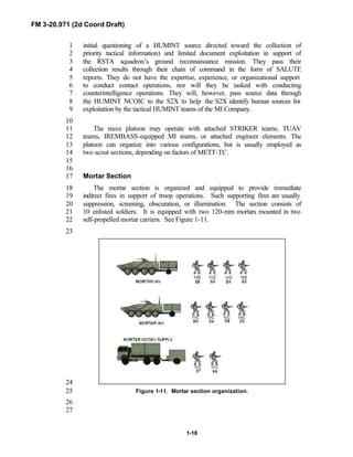
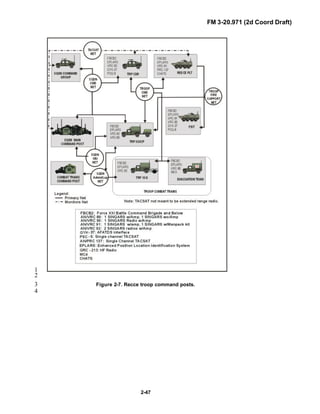
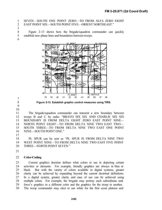
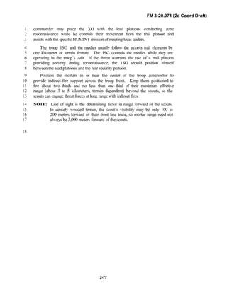
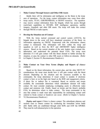
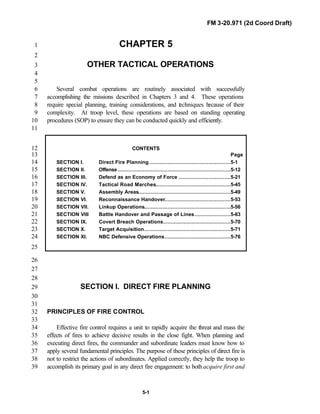
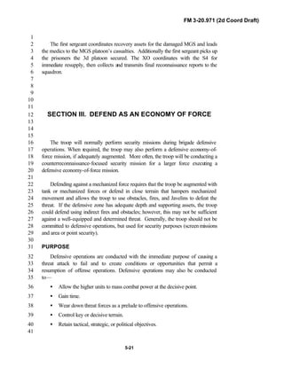
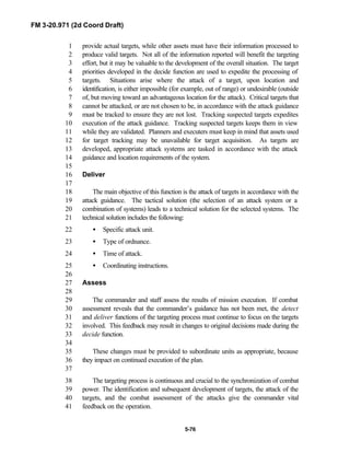
Figure 1-6. Flow of relevant information into2
situational understanding.3
4
Information superiority is the5
operational advantage derived from the6
ability to collect, process, and disseminate7
an uninterrupted flow of information8
while exploiting or denying an adversary’s9
ability to do the same. Commanders10
exploit information superiority to impact11
threat perceptions, attitudes, decisions,12
and actions to accomplish mission objectives. During the course of13
operations, all sides attempt to gain information superiority to secure an14
operational advantage while denying it to adversaries. (NOTE: See FM 3-015
[FM 100-5] for more information on information superiority.)16
17
Visualizing the Battlefield18
The greatest challenge leaders face during operations is seeing, or more19
accurately, “visualizing” the battlefield in both real time and in the future.20
Normally their physical view is limited to brief segments of the battlefield.21
They must develop an art of visualizing what is occurring or might occur22
within their area of interest. For some, this comes almost naturally. For most,23
however, it requires a great deal of experience to adequately visualize the24
complexities of the battlefield. Enhanced analog and digital communications25
(FBCB2), computers, and command/control (C4) systems in the troop portray26
key relevant threat information so that commanders and staffs can better27
visualize the battlefield and be situationally aware. Not only will these28](https://image.slidesharecdn.com/fm-3-20-140723131053-phpapp02/85/Fm-3-20-97-the-recce_and_brt_troop_draft-17-320.jpg)
![FM 3-20.971 (2d Coord Draft)
2-6
• To preserve the reconnaissance capability of the platoon, and inform1
the commander and XO of the tactical situation via FM and digitized2
contact and spot reports.3
• To lead an integrated scout/STRIKER platoon in executing both fire4
support and R&S missions.5
Reconnaissance Platoon Sergeant6
The platoon sergeant is the senior NCO in the platoon. He leads elements7
of the platoon as directed by the platoon leader and assumes command of the8
platoon in the platoon leader’s absence. He assists the platoon leader in9
maintaining discipline and exercising control. He supervises platoon CSS, to10
include supply requirements and equipment maintenance, and monitors the11
platoon’s logistics status and submits FBCB2 LOGSTAT reports.12
Fire Support Team13
The fire support team (FIST) is the critical link with the supporting14
artillery and is responsible for coordinating indirect fires (mortar, field15
artillery [FA], close air support [CAS]) for the troop. The team processes16
calls for fire from the platoons and allocates the appropriate indirect-fire17
system based on the commander’s guidance for fire support. The FIST can18
also assist the brigade/squadron with the employment of joint fires.19
NOTE: In the brigade reconnaissance troop (BRT), the STRIKER platoon20
leader may fill the role of the FIST.21
The FIST operates on three radio nets:22
• Troop command.23
• Troop fire direction.24
• Squadron fire support element digital/voice.25
26
The FIST monitors at least one of the following nets:27
• Squadron command.28
• Squadron operations and intelligence (OI).29
• Firing battery (supporting artillery headquarters in the heavy and light30
division).31
32
The fire support team vehicle also may serve as the alternate troop CP.33
The fire support officer has ready access to the higher-level situation and the34
radio systems to replicate the troop CP if it becomes damaged or destroyed.35
36
Command guidance to the FIST should include the following:37
• Purpose of indirect fires. How does the commander intend to use FA38
and mortar fires to support his maneuver?39](https://image.slidesharecdn.com/fm-3-20-140723131053-phpapp02/85/Fm-3-20-97-the-recce_and_brt_troop_draft-38-320.jpg)
![FM 3-20.971 (2d Coord Draft)
2-54
Automated Nuclear, Biological and Chemical Information System1
(ANBACIS) (Chemical [NBC] Functions)2
This software is used to report NBC strikes/warnings and to predict the3
contamination areas associated with such strikes. The software is loaded on4
select MCS computers.5
6
Digital Topographic Support System (Engineer Functions)7
This system is used by the division engineer to create topographic and8
terrain analysis products that can easily be accessed via the MCS.9
CHATS (HUMINT Collector Functions)10
This system is a portable or vehicle mounted computer system used by the11
HUMINT intelligence collectors assigned throughout the squadron to report12
HUMINT operations and maintain an operational database.13
Army Battle Command System Communications Links14
While each component of the ABCS is a powerful C2 tools individually,15
they reach their full potential when linked by a local area network (LAN), a16
wide area network (WAN), or the TI.17
Local Area Network18
A LAN network is a data communications network that interconnects19
digital devices and other peripherals. Individual systems are linked and20
distributed over a localized area to allow communication between computers21
and sharing resources. Two or more computers linked by software and22
connected by cable are considered a LAN. A LAN includes—23
• Digital devices (computers, scanners, printers, and other peripherals).24
• A communications medium that exchanges data from one device to25
another.26
• Network adapters that provide devices with an interface to the27
communications medium.28
Digital systems within a CP are normally connected on a LAN. However,29
routers on the LAN allow addressees to change as needed for jump and/or30
split operations. A tactical LAN is configured to interconnect various main CP31
shelters. Staff leaders must ensure the LAN cables are properly connected to32
their shelter/system and to the previous and next shelter/system. The S6 is the33
LAN manager for the squadron and has approval authority over all systems34
connected to the LAN. The LAN manager is responsible for physically35
establishing, connecting, and maintaining the operation and for36
troubleshooting the LAN. He is also responsible for ensuring the LAN is37
connected to the WAN. See FM 6-24.7 [FM 24-7] for additional information.38](https://image.slidesharecdn.com/fm-3-20-140723131053-phpapp02/85/Fm-3-20-97-the-recce_and_brt_troop_draft-86-320.jpg)
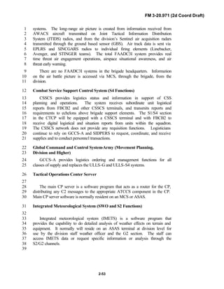
![FM 3-20.971 (2d Coord Draft)
2-56
1
Figure 2-10. Lower tactical internet.2
3
4
Upper Tactical Internet. The upper TI (or WIN-T [Warfighter5
Information Network-Terrestrial]) provides SA and C2 dissemination between6
brigade and squadron CPs and echelons above brigade CPs.7
8
9
Security10
The information architecture on the battlefield contributes significantly to11
the warfighting capabilities of units on the battlefield. The digitized12
battlefield brings a new threat—computer network attack (CNA). CNA13
includes operations the threat undertakes to disrupt, deny, degrade, or destroy14
information resident in computers and networks. To protect against CNA,15
security architecture is being developed which will involve security16
technologies, such as firewalls, intrusion detection systems, in-line network17
encryptors, and host security. The digital security requirements are defined in18
AR 380-19 and the PEO Command, Control and Communications Systems19
(PEO C3S) Security Policy.20
21](https://image.slidesharecdn.com/fm-3-20-140723131053-phpapp02/85/Fm-3-20-97-the-recce_and_brt_troop_draft-88-320.jpg)
![FM 3-20.971 (2d Coord Draft)
3-5
more detailed, comprehensive reconnaissance and surveillance mission.1
Understanding the multiple dimensions of the focus of reconnaissance is2
paramount in the troop’s understanding of the operational environment.3
Reconnaissance focus should be centered on reducing the unknowns of the4
environment based on the intelligence preparation of the battlefield (IPB)5
process and integrally connected to and fulfilling the commander’s CCIR. The6
focus of reconnaissance is characterized in these broader terms: enemy/threat,7
social/human (demographics), infrastructure, and terrain.8
9
Enemy/Threat10
11
The troop no longer faces a single, monolithic, or well-defined threat.12
During the cold war, planning centered on confronting numerically superior13
armored opposing forces in Europe, the Far East, or Southwest Asia. Today’s14
reconnaissance units must be able to conduct operations across the range of15
military operations (major theater of war [MTW], smaller-scale contingencies16
[SSC], and stability operations and support operations) against threats ranging17
in size from major regional powers to asymmetric threats. These may include18
conventional threat forces, insurgents, paramilitary forces, guerrillas, criminal19
groups, and certain civilian groups and individuals. Because of the diversity of20
the threat, the IPB process becomes even more important at the brigade,21
squadron, and troop levels. No longer will the threat always fit into a neat22
time-distance scenario. Potential adversaries may use a variety of doctrine,23
tactics, and equipment. It is extremely important to quickly identify who the24
enemy/threat is in an operational area. This will continually be the major25
focus of reconnaissance for the troop. However, reconnaissance focus may be26
the identification of the unknown threat as well. That is why the27
understanding of the society and infrastructures of an area are also an28
important focus for reconnaissance.29
30
Society (Social/Human Demographics)31
32
The focus of reconnaissance may be the society of a given area. Gaining33
an awareness of how the society impacts military operations and how military34
operations impact the local society may be critical to the commander in order35
for him and his stuff to make decisions.36
37
The center of gravity during operations may be the civilian inhabitants38
themselves. To gain and/or retain the support of the population, commanders39
must first understand the complex nature and character of the society. Second,40
they must understand and accept that every military action (or inaction) may41
influence, positively or negatively, the relationship between the urban42
population and Army forces, and by extension, mission success. Without the43
support of the society or understanding its needs, the society may become a44
threat to the brigade/military operations. With this awareness, commanders45
can plan operations, implement programs, and/or take immediate action to46](https://image.slidesharecdn.com/fm-3-20-140723131053-phpapp02/85/Fm-3-20-97-the-recce_and_brt_troop_draft-114-320.jpg)
![FM 3-20.971 (2d Coord Draft)
3-7
- Local police chief.1
- Local political leaders.2
- Local military commanders.3
- Local religious leaders.4
• Nongovernmental organization.5
• Economy.6
• Media.7
- Organizations.8
- Reporters.9
- Publications.10
- Broadcasts.11
Infrastructure12
The infrastructures are those systems that support the inhabitants and their13
economy and government. Destroying, controlling, or protecting vital parts of14
the infrastructure can isolate the threat from potential sources of support.15
Because these systems are inextricably linked, destroying or disrupting any16
portion of the urban infrastructure can have a cascading effect (either17
intentional or unintentional) on the other elements of the infrastructure.18
To successfully operate in an area, the troop must understand the local19
infrastructure. The troop must understand it physically in terms of utilities,20
transportation, and food availability as well as the many other products that21
make a community run. The troop must understand the infrastructure22
financially. What is the monetary base of the different communities, the23
income demographics, and the black market trade? Additionally, who can24
provide the friendly force with CSS needs? The troop must also understand25
the local community, political, and governmental structure. This includes26
religious, military, and paramilitary, such as local security and police forces27
that work independently from one another. The troop must develop a general28
understanding of these organizations—how they fit into the community at29
large and how they relate to one another. A reconnaissance mission focused30
on infrastructure might look at these dimensions—31
• Communications. (Wireless, telegraphs, radios, television, computers,32
newspapers, magazines, etc.)33
• Transportation and distribution. (Highways and railways [to include34
bridges, tunnels, ferries, and fords]; cableways and tramways; ports,35
harbors, and inland waterways; airports, seaplane stations, and36
heliports; mass transit; and the trucking companies and delivery37
services that facilitate the movement of supplies, equipment, and38
people.)39
• Energy. (System that provides the power to run the urban area and40
consists of the industries that produce, store, and distribute electricity,41](https://image.slidesharecdn.com/fm-3-20-140723131053-phpapp02/85/Fm-3-20-97-the-recce_and_brt_troop_draft-116-320.jpg)
![FM 3-20.971 (2d Coord Draft)
3-8
coal, oil, and natural gas. This area also encompasses alternate energy1
sources such as nuclear, solar, hydroelectric, and geothermal.)2
• Commerce. (Area includes business and financial centers [stores,3
shops, restaurants, marketplaces, banks, trading centers, and business4
offices] and outlying industrial/agricultural features [strip malls, farms,5
food storage centers, and mills] as well as environmentally sensitive6
areas [mineral extraction areas and chemical/biological facilities].)7
• Human services. (Includes hospitals, water supply systems, waste and8
hazardous material storage and processing, emergency services9
[police, fire, rescue, and emergency medical services], and10
governmental services [embassies, diplomatic organizations,11
management of vital records, welfare systems, and the judicial12
system]. The loss of any of these often has an immediate,13
destabilizing, and life-threatening impact on the inhabitants.)14
Terrain15
16
The best terrain analysis is based on a focused reconnaissance of the area17
of operation. Identifying the gaps in knowledge of the terrain that a map18
analysis cannot satisfy is the first step in terrain-focused reconnaissance. The19
troop must see the terrain as it pertains to friendly forces as well as threat20
military operations. Terrain reconnaissance includes the effect of weather on21
the military aspects of the terrain. Terrain-focused reconnaissance evaluates22
the military aspects of the terrain (OCOKA) and provides valuable23
information back to the commander to support his decisions. The side that can24
best understand and exploit the effects of terrain has the best chance of25
success.26
27
To date, cavalry and reconnaissance forces have not focused on urban28
terrain. In fact, doctrine has supported and focused on the identification of29
bypasses around urban terrain. Because of the nature of asymmetric warfare,30
threat elements will further exploit terrain to try and gain an advantage over31
US forces. In the future the troop must become more familiar with the aspects32
of complex and urban terrain. The troop must also see terrain not only in its33
traditional role but also as it might apply in a stability, support, and SSC34
environment. In a stability, support, or SSC environment, key terrain may be35
a religious or cultural monument, or an historic geographical boundary or36
town.37
38
Urban areas include some of the world's most difficult terrain in which to39
conduct military operations. Unlike deserts, forests, and jungles, which40
confront the commander with a limited variety of uniform, recurring terrain41
features, urban operations are conducted within an ever-changing mix of42
natural and manmade features. Urban areas vary immensely depending on43
their history, the cultures of their inhabitants, their economic development, the44
local climate, available building materials, and many other factors. This45](https://image.slidesharecdn.com/fm-3-20-140723131053-phpapp02/85/Fm-3-20-97-the-recce_and_brt_troop_draft-117-320.jpg)
![FM 3-20.971 (2d Coord Draft)
3-9
The reconnaissance objective must be
focused at a minimum on:
• Enemy/threat.
• Society.
• Infrastructure.
• And/or Terrain feature.
• Control measure.
The troop and higher headquarter must
endeavor to link the reconnaissance
object and the focus of reconnaissance
to:
• Commander’s critical
information requirements.
• And/or filling voids in the IPB.
• And/or supporting targeting.
variety exists not only among different urban areas but also within any1
particular area. Urban areas present an extraordinary blend of horizontal,2
vertical, interior, exterior, and subterranean forms superimposed upon the3
landscape's natural relief, drainage, and vegetation. The troop must become4
familiar with conducting terrain reconnaissance and evaluating the military5
aspects of urban terrain (OCOKA) as much as forest, desert, and jungle6
terrain. Reconnaissance leaders must become familiar with urban IPB found7
in FM 2-01.3 [FM 34-130], Intelligence Preparation of the Battlefield, and in8
FM 3-06 [FM 90-10], Urban Operations.9
10
FUNDAMENTALS OF RECONNAISSANCE11
Successful reconnaissance operations are planned and performed with the12
following six fundamentals in mind:13
• Orient on the reconnaissance objective.14
• Maximize reconnaissance assets.15
• Gain and maintain contact.16
• Develop the situation.17
• Report all information rapidly and accurately.18
• Maintain the ability to maneuver freely.19
Orient on the Reconnaissance Objective20
The commander focuses the22
efforts of the unit with a24
reconnaissance objective. This26
objective may be a terrain feature,28
control measure, enemy/threat,30
society, and or the infrastructure32
within an area of operation. During34
the IPB process, the S2 will identify36
additional intelligence requirements38
related to the enemy/threat, society,40
infrastructure and terrain. These42
intelligence requirements combined44
with the commander’s critical46
information requirements48
(CCIR)/priority intelligence50
requirements (PIR) are used as tools52
to direct the reconnaissance efforts54
of the troop. This is where the focus56
of reconnaissance is addressed in order to fill in the gaps of information and57
assist in answering the CCIR. Additionally the troop may orient its58
reconnaissance to support targeting for the squadron/brigade. This is linked to59](https://image.slidesharecdn.com/fm-3-20-140723131053-phpapp02/85/Fm-3-20-97-the-recce_and_brt_troop_draft-118-320.jpg)
![FM 3-20.971 (2d Coord Draft)
3-10
higher CCIR or may just support the targeting process. METT-TC, especially1
time, will influence which critical reconnaissance tasks can be executed2
during the conduct of the mission. Reconnaissance efforts may be focused on3
all multidimensional aspects (enemy/threat, society [human demographics],4
terrain, or the infrastructure) of an area. If reconnaissance efforts are oriented5
mainly on a threat force, the commander must specify the terrain and6
maneuverability data for the troop to gather as well as social and infrastructure7
aspects. In a stability or support operations environment, several things might8
reflect the multidimensional reconnaissance objective. In Bosnia, the9
reconnaissance objective was complying with the Dayton Peace Accord, as10
indicated by compliance with inspectors at weapons storage site facilities, the11
disbanding of illegal factional checkpoints, or the absence of police activity in12
the zone of separation.13
14
Maximize Reconnaissance Assets15
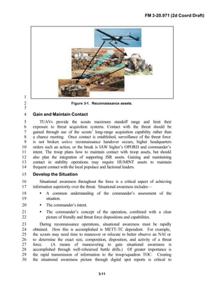
Scouts are the “eyes and ears” of the commander. With their digitized16
capabilities, scouts can provide the early warning the brigade commander17
needs to maneuver and apply his combat power as required at points of his18
choosing. Previous reconnaissance doctrine focused on maximum19
reconnaissance forward, which may still be appropriate in many situations;20
but with the increasing likelihood of noncontiguous operations,21
reconnaissance and security operations may be oriented in multiple directions.22
The troop must integrate a wide range of sensors, to include TUAVs and23
ground sensors, to ensure maximum effectiveness and survivability of ground24
scouts (see Figure 3-1). Other assets to assist the troop gain better situational25
awareness include JSTARS/U2 (imagery) and SOF intelligence operations,26
which are fed through the brigade/squadron’s Trojan system to the troop via27
reports on FBCB2. Maximizing reconnaissance is applying the right28
reconnaissance asset to the reconnaissance objective and providing29
redundancy when necessary as well as the ability to maintain contact30
throughout the depth of an OA. In most cases, the entire troop will be required31
to operate along a traditional linear front, but planning must consider the32
troop’s ability to conduct sustained operations in depth. Operating with two33
platoons oriented forward and one trailing platoon oriented rearward may be34
appropriate in some situations. In stability operations, an example would be35
maximum scout and HUMINT assets among the local populace to gather36
information.37
38](https://image.slidesharecdn.com/fm-3-20-140723131053-phpapp02/85/Fm-3-20-97-the-recce_and_brt_troop_draft-119-320.jpg)


![FM 3-20.971 (2d Coord Draft)
3-20
TACTICAL EMPLOYMENT1
Infiltration2
Infiltration is a form of maneuver that entails movement by small groups3
or individuals at extended or irregular intervals through or into an area4
occupied by an enemy or a friendly force in which contact with the enemy is5
avoided. The troop infiltrates through the area of operations to orient on the6
reconnaissance objective without having to engage the enemy or fight through7
prepared defenses. This form of maneuver is slow and often accomplished8
under reduced visibility conditions. Aerial reconnaissance provides additional9
security for the troop by locating enemy positions and identifying routes on10
which to vector ground elements to avoid enemy contact.11
If contact is necessary to force a gap in enemy defenses, the troop must be12
augmented by infantry forces, MGS, or AT offensive assets to force the13
opening in the threat’s security zone to allow the troop to infiltrate. Another14
technique is for a maneuver team to conduct a probe of threat positions and15
allow the troop to maneuver through the gap that is created. Still another16
technique is to have TUAVs, layered with SIGINT, GSR, and IREMBASS to17
locate openings through threat positions and assist the troop in infiltrating.18
Prior to infiltration, the troop commander will select individual zones or19
routes for the platoons. He will also specify actions on contact. Although the20
intent of the troop scouts is to avoid threat direct fire contact, they must know21
what actions to take upon being engaged. The troop commander establishes22
engagement criteria and issues them in his OPORD. If detected, an23
infiltration element should return fire, break contact, and report (IAW troop24
order, actions on contact, and SOPs). The troop commander will decide25
whether that element should continue the mission or return to friendly lines.26
NOTE: Refer to FM 3-20.98 [FM 17-98] for more detailed discussion of27
infiltration.28
29
Planning30
Infiltration is one of the most difficult missions the lightly armed scouts of31
the troop can accomplish. To maximize the success of the infiltration and32
enhance survivability, scouts need a detailed knowledge of the terrain and up-33
to-date information about the threat. A detailed terrain analysis can be34
conducted with the S2, using the capabilities of ASAS, DTSS, and FBCB2.35
The analysis and control team (ACT) and ASAS data bases can provide36
details related to threat locations and dispositions during infiltration planning,37
and TUAV reconnaissance flights can support both planning and execution.38
The squadron S2 and reconnaissance troop commander will review terrain39
analysis and threat data to locate threat positions and gaps in threat lines. This40
analysis also determines if the commander will move his elements on single or41
multiple infiltration lanes or zone. The overriding factor in determining42](https://image.slidesharecdn.com/fm-3-20-140723131053-phpapp02/85/Fm-3-20-97-the-recce_and_brt_troop_draft-129-320.jpg)
![FM 3-20.971 (2d Coord Draft)
3-22
operation. Recovery, resupply, and MEDEVAC support are critical planning1
aspects for aerial insertions. Deception inserts should be made en route to and2
when returning from the insertion. (See FM 3-97.4 [FM 90-4],3
FM 3-20.98 [FM 17-98], and Chapter 6, Section III, for more information4
related to aerial insertions.)5
Dismounted Infiltration. The troop commander may direct scouts to6
conduct dismounted infiltration when—7
• Time is available.8
• Stealth is required.9
• Enemy contact is expected or has been achieved through visual means.10
• Scout vehicles cannot move through an area because of terrain or11
enemy.12
• Security is the primary concern.13
Mounted Infiltration. The troop commander directs scouts to conduct14
mounted infiltration when—15
• Time is limited.16
• Enemy locations are known.17
• Distances require mounted movement.18
Though an infiltration may be primarily mounted, dismounted activities19
may be required during the operation to achieve stealth and security.20
Employment by Echelon. This technique lends itself to the flexibility21
required by a reconnaissance organization. The troop can move subordinates22
mounted and dismounted, enter the zone at different times and locations, and23
conduct different reconnaissance missions. An example of employment by24
echelon is described below.25
The brigade has a requirement to conduct surveillance of critical NAIs 3626
hours prior to the LD time. The employment of the BRT would create a27
reconnaissance gap. To solve this dilemma, the BRT commander tasks one28
platoon to infiltrate and establish surveillance of the brigade NAIs, while the29
balance of his troop prepares to conduct a zone reconnaissance forward of the30
brigade (prior to its LD).31
Checkpoints32
Checkpoints (or TIRS) should be chosen for all infiltrations/exfiltrations33
to control movement and provide command and control flexibility.34
Checkpoints can be used as a rallying point if a scout element should become35
misoriented, or the threat forces the scout element off the infiltration route or36
OP. These checkpoints should be entered on the FBCB2 systems.37](https://image.slidesharecdn.com/fm-3-20-140723131053-phpapp02/85/Fm-3-20-97-the-recce_and_brt_troop_draft-131-320.jpg)
![FM 3-20.971 (2d Coord Draft)
3-29
higher unit to maintain tempo and momentum. In terms of slowing the tempo1
of an operation, however, the loss of a platoon or team is normally much more2
costly than the additional time required to allow the subordinate element to3
properly develop the situation.4
5
Steps for Actions on Contact6
The troop should execute actions on contact using a logical, well-7
organized process of decision making. There are two types of contact the unit8
can expect and prepare for—known and chance. Known contact entails9
information and intelligence on known locations or positions of threat forces.10
Known contact actions entail these seven steps:11
• Make contact through sensors and other ISR assets.12
• Develop the situation out of contact (evaluate the situation [update the13
IPB process]).14
• Maneuver the force out of contact (choose how, with what, and where15
to make contact).16
• Make contact on your own terms (deploy and report).17
• Reevaluate and develop the situation.18
• Choose and/or recommend a COA.19
• Execute the selected COA.20
When there is no intelligence about the threat’s location, chance contact21
may be made. Chance contact actions consist of the same last four steps in22
known contact actions.23
• Deploy and report.24
• Reevaluate and develop the situation.25
• Choose and/or recommend a COA.26
• Execute the selected COA.27
28
The seven- (or four) step process is not intended to generate a rigid,29
lockstep response to the threat. Rather, the goal is to provide an orderly30
framework that enables the unit and its subordinates to survive the initial31
contact, and then apply sound decision making and timely actions to complete32
the operation. Ideally, the unit will acquire the threat (visual contact) before33
being sighted by the threat/enemy; then it can continue with visual contact or34
initiate indirect contact or physical contact on its own terms by executing the35
designated COA. It is also essential for the troop commander to understand36
the higher commander’s intent of the reconnaissance to recommend COAs for37
the brigade/squadron to react to the threat contact.38](https://image.slidesharecdn.com/fm-3-20-140723131053-phpapp02/85/Fm-3-20-97-the-recce_and_brt_troop_draft-138-320.jpg)
![FM 3-20.971 (2d Coord Draft)
4-4
ensure contact is maintained, unless otherwise directed. Ground sensors may1
identify threat movement and TUAVs and/or scouts can maintain contact. The2
reconnaissance troop may use a security drill to maintain threat contact throughout3
the depth of its assigned sector, or it may use other attached assets (i.e., TUAV or4
aerial scouts) to pass the contact back to the brigade or squadron.5
CAPABILITIES6
Capabilities of the RSTA recce troop include—7
• Screen up to a nine-kilometer-wide sector.8
• Maintain continuous surveillance of up to six avenues of approach (through9
six OPs).10
• Can establish up to 12 short-duration and six long-duration OPs.11
12
Capabilities of the BRT include—13
• Screen up to a ten-kilometer-wide sector.14
• Maintain continuous surveillance of up to six avenues of approach (through15
six OPs/NAIs [named areas of interest]).16
• Can establish up to 12 short-duration OPs (less than 12 hours in duration).17
NOTE: The maximum six long-duration OPs the troop can occupy is a function of18
personnel required to perform the following tasks:19
• Man the actual OP.20
• Maintain radio communications.21
• Provide local security.22
• Conduct dismounted patrols, as required.23
• Conduct resupply.24
• Perform maintenance.25
• Sleep/rest.26
27
COUNTERRECONNAISSANCE28
29
Counterreconnaissance is an inherent task in all security operations.30
Counterreconnaissance is not a mission. It is the sum of actions taken at all echelons31
to counter threat reconnaissance and surveillance (R&S) efforts through the depth32
of the AO. Counterreconnaissance denies the threat information about friendly units.33
It is both active and passive and includes combat action to destroy or repel threat34](https://image.slidesharecdn.com/fm-3-20-140723131053-phpapp02/85/Fm-3-20-97-the-recce_and_brt_troop_draft-187-320.jpg)
![FM 3-20.971 (2d Coord Draft)
4-9
Screening is largely accomplished by establishing a series of OPs and1
conducting patrols to ensure adequate surveillance of the assigned sector. Screens2
are active operations. Stationary OPs are only one part of the mission. Employing3
patrols (mounted and dismounted), aerial reconnaissance (TUAV), ground-based4
sensors (GSR, IREMBASS), intelligence from space-based sensor systems, and5
OPs relocated on an extended screen ensure that continuous overlapping6
surveillance occurs. Inactivity in an immobile screen promotes complacency.7
Critical Tasks8
To achieve the intent of a screen mission, the troop must accomplish the9
following critical tasks:10
• Maintain continuous surveillance of all assigned NAIs or avenues of11
approach in sector (IAW the commander’s critical information requirements12
[CCIR] and the R&S plan) with organic assets and, when augmented, with13
TUAVs and ground sensors. METT-TC and IPB will establish the time14
requirements for how and when NAIs and avenues of approach are15
observed.16
• Destroy or repel all threat reconnaissance elements within capabilities and17
based on the commander’s guidance (engagement/destruction criteria).18
Identify threat reconnaissance units and, in coordination with other combat19
elements, destroy them with reach-back precision munitions or attached20
units while not compromising scouts or the brigade.21
• Locate the lead elements that indicate the threat’s main attack orientation22
and direction prescribed in the threat’s order of battle based off the S2’s23
IPB. Provide early warning of threat approach by acquiring information24
deep, in coordination with aerial reconnaissance and ground surveillance25
sensors to be handed over to reconnaissance OPs when necessary.26
• Maintain contact with the threat’s lead element and be prepared to displace27
and report its activities (security drill).28
29](https://image.slidesharecdn.com/fm-3-20-140723131053-phpapp02/85/Fm-3-20-97-the-recce_and_brt_troop_draft-192-320.jpg)
![FM 3-20.971 (2d Coord Draft)
4-11
Command guidance should address each phase of the operation and cover at1
least the following:2
• Location/orientation/width of the screen.3
• Depth of troop sector.4
• Duration of the screen.5
• Method of movement to and occupation of the screen.6
• Location and disposition of the friendly force being screened.7
• Engagement/destruction criteria.8
• Displacement/disengagement criteria.9
• Follow-on missions.10
• Positioning and orientation guidance for GSRs, TUAVs, or other sensors (if11
attached).12
• Positioning and orientation guidance for the FIST and /or STRIKERs.13
Considerations14
15
In conjunction with the commander’s guidance, the following paragraphs16
describe the issues that must be considered when developing and completing the17
plan and executing the screen mission.18
19
Time Screen Must Be Established. The time the screen must be set and20
established will influence the troop’s method of deploying to and occupying the21
screen.22
23
Movement to Screen. If the screen mission is the result of a previous tactical24
maneuver such as zone reconnaissance, the troop will essentially be postured to25
begin screening from present positions. This situation occurs frequently, and may be26
the result of a FRAGO to halt at a specified phase line.27
If the troop is not currently set on the screen, obviously deployment to the28
screen must occur before actually beginning the screen mission. Time determines the29
method of occupying the screen. Thorough analysis of METT-TC will determine30
which deployment technique or combination of techniques best meets mission31
requirements.32
33
Trace and Orientation of Screen. The initial screen is depicted as a phase34
line and often represents the forward line of own troops (FLOT). As such, the35
screen may be a restrictive control measure for movement (limit of advance36
[LOA]); coordination/permission would be necessary to move beyond the line to37
establish OPs or to perform reconnaissance. When occupied, OPs are established38
on or behind the phase line. OPs are given specific orientation and observation39
guidance.40](https://image.slidesharecdn.com/fm-3-20-140723131053-phpapp02/85/Fm-3-20-97-the-recce_and_brt_troop_draft-194-320.jpg)
![FM 3-20.971 (2d Coord Draft)
4-19
boundary or place the boundary on a road. Place NAIs, TIRS, or checkpoints1
beyond the screen to focus surveillance and assist in the establishment of OPs. As2
the threat’s mission shifts from reconnaissance to attack, change the focus of3
observation (if necessary, change positions) to gain contact with the new threat4
formations entering the sector. If needed, add additional phase lines to control5
displacement of the troop at five-to-eight kilometer intervals. Place contact points6
at the intersection of the platoon boundary and all phase lines. Place TIRS on the7
map or overlay as described in Chapter 2.8
9
Deploy the reconnaissance platoons abreast and, as terrain allows, establish a10
series of OPs (that provide the greatest observation without compromising11
survivability) along or behind the initial screen, but never forward of it without12
permission. Make it clear to the reconnaissance platoon leaders which avenues of13
approach (depicted as NAIs or checkpoints) they are to observe. Areas between14
OPs need to be routinely checked. When this occurs, have the reconnaissance15
platoon leaders prepare patrol plans for approval and subsequent execution.16
17
When augmented with ground sensors, place these assets to observe avenues of18
approach that are out of visual observation to maximize early detection of the19
threat’s approach. Additionally these assets can be oriented on dismounted avenues20
of approach in restricted terrain. TUAVs should be oriented to look deep to gain21
contact with suspected or detected threat movement. Once the threat main elements22
are identified, TUAVs also assist in the displacement and repositioning of ground23
scouts. The TUAVs maintain contact as the platoons conduct security drills IAW24
the commander’s displacement criteria. TUAVs provide a tremendous target25
acquisition capability for indirect and joint fires. TUAVs and ground sensors can be26
used to develop the situation and hand off targets to the ground scout without27
unexpected contact. The troop commander must plan for and maximize the use of28
additional ISR assets in the surveillance troop. This includes information the29
squadron/brigade will receive from division/corps assets as well as joint and national30
assets (joint surveillance target attack radar system [JSTARS], Guardrail, and other31
imagery intelligence [IMINT] and signal intelligence [SIGINT]).32
33
Position the mortar section to fire from one-third to two-thirds of its maximum34
firing range forward of the initial screen, oriented on the expected threat avenue of35
approach. Establish subsequent firing positions for the mortar section back through36
the sector. Plan positions for the FIST/FSO to best execute fires in support of the37
troop’s counterreconnaissance fight and then to harass and impede the threat’s main38
elements.39
40
Identify positions to deploy scouts in an antiarmor role. Scouts should determine41
ambush locations for their antiarmor assets for defense of their OPs and for42
counterreconnaissance (IAW the commander’s destruction/ engagement criteria).43](https://image.slidesharecdn.com/fm-3-20-140723131053-phpapp02/85/Fm-3-20-97-the-recce_and_brt_troop_draft-202-320.jpg)

![FM 3-20.971 (2d Coord Draft)
5-4
positions, whether offensive or defensive, must be adjusted closer to the area or1
point where the commander intends to focus fires. Another alternative is the use of2
visual or IR illumination when there is insufficient ambient light for passive light3
intensification devices. (NOTE: Vehicles equipped with thermal sights can assist4
dismounted scout and infantry squads in detecting and engaging threat infantry5
forces in conditions such as heavy smoke and low illumination.)6
7
8
Develop Contingencies for Diminished Capabilities9
10
Leaders initially develop plans based on their units’ maximum capabilities; they11
make backup plans for implementation in the event of casualties or weapon damage12
or failure. While leaders cannot anticipate or plan for every situation, they should13
develop plans for what they view as the most probable occurrences. Building14
redundancy into these plans, such as having two systems observe the same sector,15
is an invaluable asset when the situation (and the number of available systems)16
permits. Designating alternate sectors of fire provides a means of shifting fires if17
adjacent elements are knocked out of action.18
19
20
FIRE CONTROL PROCESS21
22
To successfully bring direct fires against a threat force, commanders and leaders23
must continuously apply the steps of the fire control process. At the heart of this24
process are two critical actions: rapid, accurate target acquisition and the massing25
of fire to achieve decisive effects on the target. Target acquisition is the detection,26
identification, and location of a target in sufficient detail to permit the effective27
employment of weapons. Massing entails focusing fires at critical points and then28
distributing the fires for optimum effect. Target acquisition is an inherent function of29
the recce troop. The fundamentals and critical tasks associated with reconnaissance30
and security missions (see Chapters 3 and 4) are the basis of target acquisition and31
should be applied. However, the following discussion examines target acquisition32
and how it applies to massing of fires. Use these basic steps of the fire control33
process:34
• Identify probable threat locations and determine the threat scheme of35
maneuver.36
• Determine where and how to mass (focus and distribute) fire effects.37
• Orient forces to speed target acquisition.38
• Shift fires to refocus or redistribute their effects.39
NOTE: Refer to FM 3-91.3 [FM 71-1] for detailed direct fire control information.40](https://image.slidesharecdn.com/fm-3-20-140723131053-phpapp02/85/Fm-3-20-97-the-recce_and_brt_troop_draft-231-320.jpg)
![FM 3-20.971 (2d Coord Draft)
5-5
1
2
Identify Probable Threat Locations and Determine the Threat3
Scheme of Maneuver4
5
Acquiring the threat is a precursor to direct fire engagement; however, units will6
not always be able to see the threat and they will not always have additional sensor7
assets to give early warning of the threat’s advance. Rather, the acquisition of the8
threat will often be dependent on recognition of very subtle indicators that may be9
especially difficult to see while moving. Examples include exposed antennas,10
reflections from the vision blocks of threat vehicles, small dust clouds, smoke from11
vehicle engines, or fires from ATGMs or tanks.12
13
Because of the difficulty of target acquisition, the troop commander must14
develop unit surveillance plans to assist the team in acquiring the threat. He must15
also be prepared to apply these techniques to help orient other friendly forces.16
Techniques for unit surveillance, target acquisition, and orientation of subordinate17
elements are discussed in detail in this chapter and on a larger scale in Chapters 318
and 4. Target acquisition at the crew level and crew gunnery techniques are19
discussed in detail in FM 3-20.98 [FM 17-98-2], the reconnaissance platoon20
manual, and applicable gunnery manuals.21
22
The commander and subordinate leaders plan and execute direct fires based on23
their estimate of the situation. An essential part of this estimate is the analysis of the24
terrain and the threat force, which aids the commander in visualizing how the threat25
will attack or defend a particular piece of terrain. A defending threat’s defensive26
positions or an attacking threat’s support positions are normally driven by27
intervisibility. Typically, there are limited points on a piece of terrain that provide28
both good fields of fire and adequate cover for a defender. Similarly, an attacking29
threat will have only a limited selection of avenues of approach that provide30
adequate cover and concealment. Coupled with available intelligence, an31
understanding of the effects of a specific piece of terrain on maneuver will assist the32
commander in identifying probable threat locations and likely avenues of approach33
both before and during the fight. Figure 5-1 illustrates the commander’s analysis of34
threat locations and scheme of maneuver; he may use any or all of the following35
products or techniques in developing and updating the analysis:36
• A SITEMP based on the analysis of terrain and threat.37
• A spot or contact report on threat locations and activities.38
• Reconnaissance of the area of operations.39
40](https://image.slidesharecdn.com/fm-3-20-140723131053-phpapp02/85/Fm-3-20-97-the-recce_and_brt_troop_draft-232-320.jpg)
![FM 3-20.971 (2d Coord Draft)
5-13
deprive the threat of resources, to gain information, to deceive and divert the threat,1
to hold the threat in position, to disrupt a threat attack, and to set up conditions for2
future successful operations.3
4
FUNDAMENTALS5
6
Successful offensive operations have four fundamentals.7
• Surprise. Strike the threat at the time and place or in a manner that is least8
expected.9
• Concentration. Mass available forces; strive for overwhelming superiority10
in men, weapons, and firepower. With concentration, however, vulnerability11
becomes a factor. A force that is dispersed is much more survivable. The12
commander must maintain a high sense of situational awareness to anticipate13
the conditions of battle that will allow him to mass at the critical point, kill14
the threat, and quickly disperse to survive.15
• Tempo. Tempo is the rate of speed of military action. Controlling or altering16
the rate is essential for maintaining the initiative. Tempo can be fast or slow,17
depending on the capabilities of the troop relative to those of the threat.18
Commanders must adjust tempo to ensure synchronization.19
• Audacity. Boldness in the plan’s execution is key to success in offensive20
operations. Commanders should understand when and where they are21
taking risks, but must not become tentative when executing their plan.22
23
HASTY ATTACK24
25
A hasty attack is conducted with a minimum of preparation to defeat a threat26
force that is not prepared or deployed to fight. It is a course of action routinely27
employed in reconnaissance operations to seize or retain the initiative, or to sustain28
the tempo of operations. A hasty attack can be executed while the troop is engaged29
in a zone reconnaissance mission.30
31
Critical Tasks32
33
To successfully execute a hasty attack, the following critical tasks must be34
accomplished:35
• Reconnoiter and determine the size, composition, and orientation of the36
threat force (with tactical unmanned aerial vehicles [TUAV], ground37
surveillance radar [GSR], mounted and dismounted scouts).38
• Determine if the objective threat force is supported by other units nearby39
(using TUAV, GSR, scouts).40](https://image.slidesharecdn.com/fm-3-20-140723131053-phpapp02/85/Fm-3-20-97-the-recce_and_brt_troop_draft-240-320.jpg)
![FM 3-20.971 (2d Coord Draft)
5-14
• Find a high-speed, covered and concealed approach into the threat’s1
flank(s) (using TUAV, GSR, scouts).2
• Establish a maneuver element (usually an armored element attached from3
the brigade) to move to a position of advantage and attack the threat by4
fire.5
• Establish a base-of-fire element (usually one or, if possible, two platoons) to6
defeat or suppress all observed threat AT weapons with long-range direct7
and indirect fires before the maneuver force deploys into its attack.8
• Isolate the objective threat force from other mutually supporting units with9
indirect fires (usually with smoke and HE mortar/FA ammunition, or a scout10
platoon).11
• Attack the threat by fire or by fire and maneuver, and defeat it.12
• Once the attack is completed, immediately establish hasty defensive13
positions and OPs on high-speed avenues of approach into the troop14
position.15
Techniques16
17
Each critical task has a time at which it will be accomplished in relation to all18
other critical tasks. A good hasty attack depends on the commander’s sense of19
timing and on his ability to employ his forces to accomplish the tasks in the proper20
sequence. The commander has to synchronize—concentrate and apply different21
forms of combat power against the threat at the right times and places. The decision22
to conduct a hasty attack is usually made after a reconnaissance of a threat force,23
and dispositions show that winning requires a quick strike with little preparation.24
Under no circumstances should a hasty attack be ordered unless the threat position25
has been thoroughly reconnoitered and the individual positions are known. Tactics26
for conducting a hasty attack have three features:27
• Known or suspected threat AT weapons are suppressed and destroyed28
with direct and/or indirect fires before the maneuver force is committed.29
• The threat is forced to fight in two directions.30
• The threat is suppressed and unable to react.31
32
Establishing the Conditions for a Hasty Attack33
34
While conducting other missions, scouts will often make contact with a threat35
force. In developing the situation (based on the engagement criteria from36
commander’s reconnaissance guidance [see Chapter 3], what is a troop fight versus37
a platoon fight), a scout platoon may recommend hasty attack as a course of action38
to the troop commander, who decides to execute the recommended course of39](https://image.slidesharecdn.com/fm-3-20-140723131053-phpapp02/85/Fm-3-20-97-the-recce_and_brt_troop_draft-241-320.jpg)
![FM 3-20.971 (2d Coord Draft)
5-32
• Displacement to alternate, supplementary, or successive OPs/BPs.1
• Cross-leveling or resupply of Class V.2
•• Evacuation of casualties.3
NOTE: The troop commander should coordinate the troop rehearsal with the4
squadron to ensure other units’ rehearsals are not planned for the same5
time and/or location. Coordination will lead to more efficient use of6
planning and preparation time for all the squadron’s units. It will also7
eliminate the danger of misidentification of friendly forces in the rehearsal8
area, which could result in fratricide.9
10
11
DEFENSIVE SCHEMES OF MANEUVER12
13
There are three basic schemes of maneuver the commander can use in14
designating a course of action for a defensive mission:15
• Defend from a troop battle position.16
• Defend in troop sector.17
• Delay.18
19
These schemes of maneuver center on the use of battle positions and sectors for20
subordinate platoons, or a combination of the two. For a detailed discussion of21
defensive operations, see FM 3-40 [FM 100-40 (draft)] or FMs 3-20.95 [FM 17-22
95] and 3-20.97 [FM 17-97].23
24
Defend From a Troop Battle Position25
26
When properly augmented, the troop may defend from a battle position. This is27
usually done when the threat situation is clear and there is only one avenue of28
approach. In this scheme of maneuver, the troop commander retains most of the29
authority for fighting the battle. The troop commander must understand his higher30
commander’s intent and concept to prevent holding the troop in place and risking its31
destruction. This mission is normally assigned when the higher commander elects to32
concentrate the direct fires of the troop or squadron/brigade within an engagement33
area. The troop cannot maneuver outside the position without the higher34
commander’s permission. Within the battle position, the troop commander positions35
his platoons to concentrate all direct fires where the squadron has specified. The36
troop fights to retain the position unless ordered by the higher commander to37
counterattack or withdraw.38
39
40](https://image.slidesharecdn.com/fm-3-20-140723131053-phpapp02/85/Fm-3-20-97-the-recce_and_brt_troop_draft-259-320.jpg)

![FM 3-20.971 (2d Coord Draft)
5-51
available, an advance party should conduct a ground reconnaissance. The troop1
SOP should have a standard assembly area occupation drill and layout.2
QUARTERING PARTY3
Special care is taken to ensure that FBCB2 communication is possible between4
the quartering party OIC and the troop CP. Prior to quartering party movement,5
the vehicles within the quartering party will display the automated operations overlay6
on their tactical displays. This overlay typically includes the movement route,7
waypoints, specific critical points, and the assembly area. Additional control8
measures, such as contact points, coordination points, observation points, and9
screen lines, may be included to enhance control and/or security. If fire support,10
obstacle, and threat overlays are also available, quartering party members should11
study and store these in their FBCB2.12
During movement, the quartering party leader passes critical information to the13
troop CP via FBCB2 or FM voice. The quartering party annotates changes to the14
published route on the FBCB2 overlays and updates the troop CP by forwarding15
overlay updates.16
17
Normally, the XO or 1SG will lead the quartering party into the AA. When the18
quartering party arrives at the forward AA, they must—19
• Reconnoiter the area. If the area is not suitable, report immediately and20
provide recommendations.21
• Organize the area. Select locations for all elements of the troop based on22
the commander’s instructions or as terrain, cover, and concealment dictate.23
Select general locations for vehicles. Vehicle commanders and the chain of24
command refine these positions when they arrive.25
• Improve and mark entrances, exits, and internal routes.26
• Update the overlay to reflect any changes in the location of the assembly27
area and any obstacles encountered.28
• Perform guide duties as required. Platoon representatives guide their29
elements into position after clearing the release point.30
NOTE: Refer to FM 3-20.98 [FM 17-98] for a detailed discussion of quartering31
party activities.32
33
34](https://image.slidesharecdn.com/fm-3-20-140723131053-phpapp02/85/Fm-3-20-97-the-recce_and_brt_troop_draft-278-320.jpg)
![FM 3-20.971 (2d Coord Draft)
5-59
When possible, the commanders of the units involved establish liaison. If the1
threat is between the forces conducting a linkup, this liaison may not occur and2
coordination is then accomplished by radio or through FBCB2. During the3
operation, the two units attempt to maintain continuous radio contact with each4
other or the higher headquarters. As a minimum, the units exchange the following5
information:6
• Threat and friendly situation.7
• Locations and types of obstacles.8
• Fire support plans (especially RFL and coordinated fire line [CFL]).9
• Possible routes to the objective.10
• Communications.11
• Recognition signals.12
• Contingency plans.13
14
Every effort should be made to establish a face-to-face liaison. If a face-to-15
face linkup is not possible, establish a reliable digital and/or voice linkup to16
exchange critical information. As the distance closes between the forces, the17
requirement to maintain close liaison and exchange information increases. Linkup18
operations frequently require a passage of lines. Once through, the troop moves to19
the linkup. The action is characterized by speed, aggressiveness, and boldness.20
Threat forces that threaten the successful accomplishment of the mission are21
destroyed. Others are bypassed and reported.22
23
The communication plan includes radio frequencies, net IDs, EPLRS needlines,24
host files required to conduct the linkup (if units are from different maneuver control25
systems), and COMSEC variables for communication between the two forces. It26
must prescribe day and night identification procedures, including primary and27
alternate means. Visual signals such as flares or panels may be used during daylight,28
and flashlights or infrared devices may be employed during darkness. To prevent29
friendly troops from exchanging fires, recognition signals must be established. They30
may be pyrotechnics, armbands, vehicle markings, panels, colored smoke,31
distinctive light patterns, and passwords. Using the BCIS and situational awareness32
via FBCB2 greatly enhances friendly recognition.33
34
Logistical requirements may be greater during linkup operations than during35
other offensive actions. Additional considerations for linkup include—36
• Distance to the linkup.37
• Time the objective area is to be held.38](https://image.slidesharecdn.com/fm-3-20-140723131053-phpapp02/85/Fm-3-20-97-the-recce_and_brt_troop_draft-286-320.jpg)

![FM 3-20.971 (2d Coord Draft)
5-71
• Troop density. The passing troop commander should plan for multiple1
routes of passage to ensure rapid movement and to avoid congestion.2
• Traffic control. Guides from the stationary unit pick up passing elements at3
each contact point and guide them through the position. The passing unit4
commander tells the stationary unit the type, number, and order of vehicles5
passing through each contact point.6
• Communications. Leaders exchange SOI and FBCB2 IP address7
information and mutually agreed upon recognition signals.8
• CSS. The troop commander submits the required digital reports to effect9
the evacuation of casualties, EPWs, vehicles, and resupply of fuel and10
ammunition. The stationary unit usually provides immediate CSS only.11
(Usually the troop commander will coordinate a forward passage of lines12
and the XO coordinates a rearward passage. If the troop commander or13
XO is not available, a platoon leader or platoon sergeant should perform14
these liaison functions. In this case, the liaison officer must be thoroughly15
briefed on the situation and follow the checklist in the troop SOP.)16
17
18
SECTION IX. COVERT BREACH OPERATIONS19
The covert breach is a special breaching operation conducted by scouts,20
engineers, or dismounted infantry during limited visibility. It relies on stealth, quiet21
lane reduction techniques, and dismounted maneuver to achieve surprise and to22
minimize casualties. The limited dismounted capability of the troop must be weighed23
during breach operations to determine if surprise can be achieved. FM 3-34.2 [FM24
90-13-1] outlines the doctrine for combined arms breaching operations and covers25
all four types of breaches in explicit detail.26
The engineer reconnaissance element placed OPCON to the troop aids in27
breach operations. This element provides the commander technical advice as to the28
effort and equipment required to breach obstacles. The actual breaching abilities of29
the engineer reconnaissance element are limited to manual methods.30
31
A covert breach may be executed when stealthy reconnaissance is key to the32
infiltration efforts of the troop and surprise is integral to the assault of a position or33
follow-on attack. The covert breach will also be conducted during climatic34
conditions that support such operations (e.g., limited visibility). The commander will35
also use a covert breach when his available combat power is not needed to support36
a follow-on assault.37
38](https://image.slidesharecdn.com/fm-3-20-140723131053-phpapp02/85/Fm-3-20-97-the-recce_and_brt_troop_draft-298-320.jpg)
![FM 3-20.971 (2d Coord Draft)
5-72
Obstacles at the breach site are normally reduced by a reduction team using1
silent techniques, such as:2
• Marking mines.3
• Cutting wire.4
• Reshaping an antitank ditch with shovels.5
• Setting explosive charges and waiting for a signal or trigger to detonate6
them.7
The difference between the covert breach and other breaching operations is8
execution of the breaching fundamentals (i.e., SOSR—suppress, obscure, secure,9
reduce). Suppression is planned, but remains “on call” until the assault begins.10
Obscuration is achieved through the use of smoke or conducting the operations11
under limited visibility. Security is provided by the security team of the breach force12
and includes early warning and covering the withdrawal of the reduction team. See13
FM 3-11.50 [FM 3-50] for more detailed information on smoke operations.14
15
SECTION X. TARGET ACQUISITION16
17
Target acquisition (TA) is the detection, identification, and location of a target in18
sufficient detail to permit the effective employment of weapons. With the advances19
of precision munitions and the systems to rapidly deliver them from relatively safe20
locations, the likelihood of the troop’s reconnaissance mission being focused on21
target acquisition is increased exponentially. The process itself is embedded in all22
reconnaissance operations.23
24
Target acquisition, development through execution, is a critical task in all troop25
missions. The information that supports the troop and its higher headquarters26
targeting and fire support plan is a major portion of the information passed during a27
reconnaissance handover. Target acquisition may be an objective or a focus of a28
reconnaissance mission. ISR assets gather targeting information and targets by29
using all available means. These means include, but are not limited to:30
31
• OH-58A/C and OH-58D helicopters.32
• TUAV.33
• STRIKERs.34
• FISTs.35
• Scouts.36](https://image.slidesharecdn.com/fm-3-20-140723131053-phpapp02/85/Fm-3-20-97-the-recce_and_brt_troop_draft-299-320.jpg)
![FM 3-20.971 (2d Coord Draft)
5-77
1
SECTION XI. NBC DEFENSIVE OPERATIONS2
3
NBC defensive operations reduce casualties and damage to equipment and4
materiel, and minimize confusion and interruption of the troop’s mission in the event5
of threat NBC attacks. These operations are performed concurrently with all6
combat operations to preserve the fighting strength of the troop.7
8
The troop’s NBC defense personnel are an NBC trained officer (usually the9
platoon leader), an MOS-qualified NBC NCO, and an enlisted alternate.10
11
The NBC officer supervises troop NBC defense activities and assists the12
commander in training NBC equipment operators. The NBC NCO and his13
alternate directly supervise radiological monitoring, chemical detection, and14
decontamination operations. During combat operations, the NBC NCO is located15
in the troop CP where he—16
• Receives, prepares, evaluates, and digitally disseminates information and17
reports threat and friendly NBC attacks via FBCB2 and FM.18
• Supervises employment of detection, monitoring, and surveying operations.19
• Maintains unit radiation exposure status records.20
• Assists the troop commander in analyzing guidance from the21
brigade/squadron for mission, threat, and weather as they affect NBC22
operations and recommends appropriate MOPP level based on this23
information.24
To facilitate operations in an NBC environment, all soldiers must be proficient in25
operating the assigned NBC detection equipment. The troop SOP may designate26
teams for NBC operations based on MTOE equipment authorizations. See FM 3-27
11 [FM 3-100] for detailed discussions on NBC techniques and procedures for28
operations in an NBC environment.29
30
31
NOTE: Refer to Appendix B for a detailed discussion of troop NBC operations.32
33](https://image.slidesharecdn.com/fm-3-20-140723131053-phpapp02/85/Fm-3-20-97-the-recce_and_brt_troop_draft-304-320.jpg)
![FM 3-20.971 (2d Coord Draft)
6-1
CHAPTER 61
COMBAT SUPPORT2
The troop commander must know the capabilities and limitations of CS3
assets, how to properly employ them, effectively integrate them into his4
overall scheme of maneuver, and ensure they are synchronized during5
operations.6
With digitization, CS elements possess greater situational awareness and7
are better able to support troop tactical situations. The interoperability of8
these maneuver and CS digital systems enhances the brigade/squadron and9
troop commander’s ability to quickly synchronize operations and apply10
superior combat power at the decisive place and time on the battlefield.11
12
CONTENTS13
Page14
SECTION I. Intelligence ....................................................................6-115
SECTION II. Fire Support/Target Acquisition .....................................6-1616
SECTION III. Army Aviation ................................................................6-3617
SECTION IV. Tactical Unmanned Aerial Vehicle Platoon ...................6-6318
SECTION V. Multi-Sensor Platoon......................................................6-6719
SECTION VI. IBCT Infantry Rifle Company..........................................6-7320
SECTION VII. Mobile Gun System Platoon...........................................6-8321
SECTION VIII. Infantry Battalion Reconnaissance Platoon ...................6-8622
SECTION IX. Antitank Platoon/Company ............................................6-8823
SECTION X. NBC Reconnaissance .....................................................6-9224
SECTION XI. IBCT Engineer Company................................................6-9325
SECTION XII. Air Defense ....................................................................6-9826
27
SECTION I. INTELLIGENCE28
While only the recce troop has 97Bs (human intelligence [HUMINT]29
collectors) assigned, the BRT utilizes HUMINT as well. Reconnaissance30
organizations have used information gained from locals and prisoners from31
the beginning of organized warfare. HUMINT operations are an integral part32
of the troop’s reconnaissance effort. The operational environment of the troop33
offers a wide array of human intelligence sources, to include enemy prisoners34
of war (EPW), detained persons, refugees, local inhabitants, and friendly35](https://image.slidesharecdn.com/fm-3-20-140723131053-phpapp02/85/Fm-3-20-97-the-recce_and_brt_troop_draft-305-320.jpg)
![FM 3-20.971 (2d Coord Draft)
6-5
HUMINT Collection in Support of Stability Operations or Support1
Operations2
The primary focus of the HUMINT collectors during stability operations3
or support operations is intelligence support for force protection. Centralized4
management and databases are key to successful HUMINT operations in5
support of force protection. The HUMINT collectors organic to the recce6
troop will normally be allocated to individual reconnaissance squads, as7
necessary, to provide a language and tactical questioning ability, to translate8
and exploit foreign documents, and to identify individuals as potential9
counterintelligence (CI) sources to be more fully exploited by the HUMINT10
platoon in the MI Company. The HUMINT teams establish a network of11
force protection sources, debrief casual sources, and interview/debrief local12
national employees to increase the security posture of US forces, to provide13
information in response to command collection requirements, and to provide14
early warning of threats to US forces. The HUMINT collectors develop both15
the overall HUMINT picture and the more specific threat intelligence16
collection (CI) picture. Additionally, the HUMINT collector is in the position17
to articulate the friendly force’s position and draw commonality with the local18
populace while dispelling antifriendly propaganda.19
DOCUMENT EXPLOITATION OPERATIONS20
Document exploitation (DOCEX) is the extraction and exploitation of21
information with intelligence value from documents, to include all types of22
written or recorded media. The HUMINT teams perform limited exploitation23
of documents for information of immediate tactical interest dealing primarily24
with documents found on or in immediate association with EPWs, civilian25
detainees, refugees, and other HUMINT sources. In their traditional role,26
HUMINT collectors review captured orders and maps. In stability operations,27
as an example, they monitor election posters in different ethnic areas.28
The exploitation of documents captured on or in association with29
HUMINT sources is performed in conjunction with the initial tactical30
questioning of these individuals. Documents that cannot be exploited by the31
HUMINT teams in a timely fashion (due to their size or technical nature) are32
scanned and transmitted to higher for translation and exploitation.33
See FM 2-22.3 [FM 34-52] and FM 2-00.5 [FM 34-5] for more detailed34
information on HUMINT operations.35
TACTICAL QUESTIONING36
When conducted properly, tactical questioning elicits valuable, timely and37
accurate information from the local populace. When conducted improperly,38
you will confuse the subject, waste time, and receive inaccurate information.39
Tactical questioning must answer who, what, where, when, how, and why.40](https://image.slidesharecdn.com/fm-3-20-140723131053-phpapp02/85/Fm-3-20-97-the-recce_and_brt_troop_draft-309-320.jpg)
![FM 3-20.971 (2d Coord Draft)
6-12
ISR Integration Platoon1
The MI Company’s ISR Integration Platoon conducts ISR requirements2
management; HUMINT collection, planning, and deconfliction; and3
multisensor visualization (through the common ground station [CGS]) for the4
brigade commander and staff in support of the brigade S2 section. The platoon5
consists of an ISR Management Team, an S2X Team, and a CGS team. This6
organization allows continuous and dynamic control of the brigade’s ISR7
assets with special capabilities to direct tactical HUMINT operations through8
the S2X and access nonorganic sensors via the CGS.9
ISR Management Team10
The ISR Management Team is responsible for developing, monitoring,11
and dynamically adjusting the brigade’s ISR collection effort. It participates12
in the brigade staff wargaming and synchronization session to extract ISR13
requirements that answer the commander’s decision making and targeting14
needs. The team also works closely with the brigade S2 Operations Team to15
identify shortcomings in current and near-term ISR support. With ISR16
requirements for both current and future operations, the team develops and17
adjusts ISR collection plans, orders, and requests to position ISR assets to18
deliver combat information, targeting data, and intelligence to the commander19
and staff.20
By simultaneously monitoring the current situation and future planning,21
the team can rapidly recognize and redirect ISR assets to respond to situations22
that are significantly divergent from the assumed threat COAs that led to the23
current concept of maneuver, fires, or information operations. Collaboration,24
both virtual and analyst-to-analyst, between the ISR Management Team and25
the S2 section is essential to the synchronization of the ISR effort and26
presentation of the most current intelligence possible to the brigade27
commander and staff. Some specific ISR Management Team tasks are to—28
• Develop and recommend PIR for the brigade commander’s approval.29
• Develop specific information requirements for each PIR.30
• Develop multidiscipline, multiechelon, and cross-battlefield operating31
system-specific orders and requests.32
• Coordinate the development and inclusion of ISR tasks into Paragraph33
3 (Execution) of the OPORD.34
• Maintain the ISR collection plan in Annex B (Intelligence) of the35
OPORD.36
• Coordinate the development and dissemination of Annex L (R&S) of37
the OPORD.38](https://image.slidesharecdn.com/fm-3-20-140723131053-phpapp02/85/Fm-3-20-97-the-recce_and_brt_troop_draft-316-320.jpg)
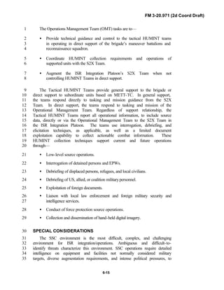
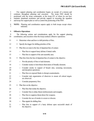
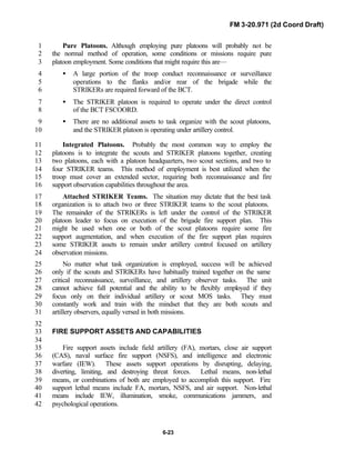
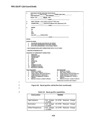
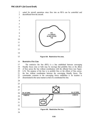
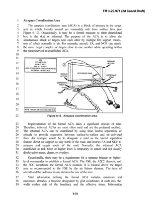
![FM 3-20.971 (2d Coord Draft)
6-36
concerning the ACA is disseminated in the same way that it is for the1
coordinated fire line.2
SECTION III. ARMY AVIATION3
AIR CAVALRY4
Air cavalry may be under operational control of the brigade or the RSTA5
squadron to augment reconnaissance troop operations. Troops and platoons6
must therefore be prepared to establish a close working relationship with air7
cavalry troops. Through its mobility and speed, air cavalry gives the troop8
commander added flexibility, increasing the speed with which reconnaissance9
is conducted. Refer to FM 3-20.95 [FM 17-95] and FM 3-04.114 [FM 1-114]10
for doctrine on air cavalry operations. See Figure 6-11 for air cavalry troop11
organization.12
13
14
Figure 6-11. Air cavalry troop organization.15
Employment Considerations16
The aeroscout platoon consists of four aircraft, led by a lieutenant. It17
includes a flight examiner, instructor pilot, and individual aircraft pilots. Its18
primary mission is to conduct armed R&S missions.19
The primary aircraft in air cavalry units is the OH-58D(I) Kiowa Warrior.20
This helicopter provides the maneuver commander with a versatile platform; it21
can be armed with various weapon systems and is suitable for employment in22
numerous types of situations and operations.23
The aircraft features a stabilized mast mounted sight (MMS) with a low-24
light TV camera, thermal imaging system, and laser range finder/designator.25
The aircrew of the Kiowa Warrior can detect a heat source in day or night26
conditions at a range up to 15 kilometers and is capable of providing laser27](https://image.slidesharecdn.com/fm-3-20-140723131053-phpapp02/85/Fm-3-20-97-the-recce_and_brt_troop_draft-340-320.jpg)
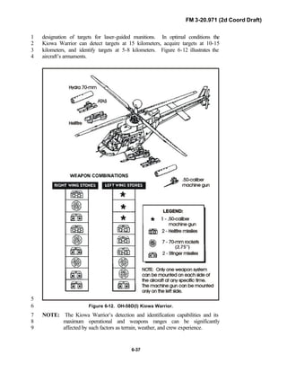
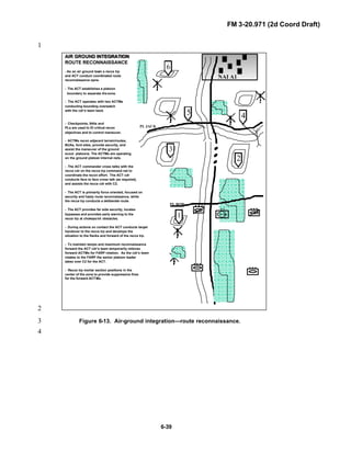
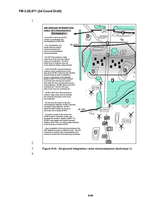
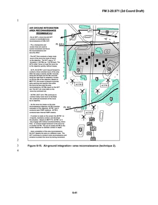
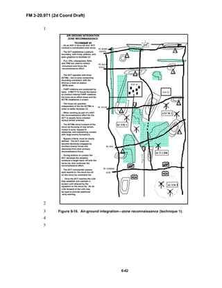
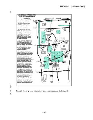
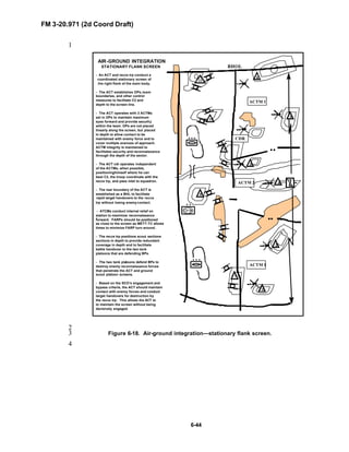
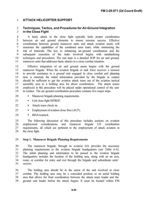
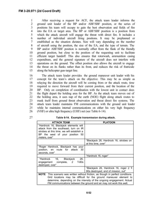
![FM 3-20.971 (2d Coord Draft)
6-56
ASSAULT (UTILITY) AND CARGO (LIFT) HELICOPTER SUPPORT1
Resupply Operations2
Aerial resupply operations provide the squadron/BRT commander with a3
flexible, responsible means to resupply his force. Although limited by4
weather and threat air defense systems, aerial resupply enables the5
commander to bypass congested supply routes, destroyed bridges, and most6
terrain obstacles to deliver supplies where they are most needed. At brigade7
level and below, aerial resupply is generally confined to helicopters.8
9
Planning Considerations10
Close coordination between all players must occur. The entire mission is11
reviewed and all limitations and problem areas resolved. If a particular12
problem cannot be resolved, another mode of transport should be considered13
for the item of equipment that presents the problem.14
Planning for aerial resupply must consider the following factors:15
• Type/amount of cargo to be carried.16
• Helicopter assets available.17
• Sling/cargo net/cargo container requirements.18
• Ground crew training requirements.19
• Selection of the PZ/LZ.20
• Integration into the tactical plan.21
• Priorities of cargo/unit resupply.22
• PZ/LZ security.23
24
Helicopter resupply assets are limited. Internal to the division, the combat25
aviation company of the combat aviation brigade (CAB) provides the only26
organic utility helicopter support. Normally, corps aviation assets provide27
aerial resupply support. Requests for support are routed through the squadron28
S3 to the division G3 for action. See brigade or division SOP for request29
format and procedures. Refer to FM 3-04.113 [FM 1-113] for additional30
information.31
32](https://image.slidesharecdn.com/fm-3-20-140723131053-phpapp02/85/Fm-3-20-97-the-recce_and_brt_troop_draft-360-320.jpg)
![FM 3-20.971 (2d Coord Draft)
6-60
Table 6-18. MEDEVAC transmission.1
MEDEVAC AIRCRAFT GROUND MANEUVER PLATOON
“Hardrock 06, Dustoff 26 is 30 seconds
inbound to your location, request
terminal guidance, over”
“Dustoff 26, Hardrock 06, signal is
displayed, over”(use method in 9 line
request)
“Roger Hardrock, Dustoff has green
smoke, over”
“Hardrock 06, roger green smoke,
over”
Forward Arming and Refueling Point Operations2
Establishing a forward arming and refueling point (FARP), using UH-60s3
and CH-47s in the Fat Hawk/Fat Cow mode, is a viable refueling and4
rearming option for the brigade/squadron to support the troop. A FARP5
operation should not be considered for routine fuel and ammunition resupply.6
It should be used for emergency situations only. FM 3-04.111 [FM 1-111]7
provides complete details on FARP operations.8
A FARP can be used by the squadron as a temporary arming and refueling9
facility that is organized, equipped, and deployed by an aviation unit10
commander to support the squadron’s mission. The FARP provides fuel and11
ammunition resupply for the squadron/troop when it is conducting cross-12
FLOT operations. The fluid situation of the battlefield demands that it be13
austere, transitory, and able to support specific mission objectives. The FARP14
is a lucrative target and must be secured with squadron assets. Threat15
observation and engagement must be avoided. The FARP is operated and16
organized according to the factors of METT-TC.17
The utility or cargo helicopter’s ability to move combat assets quickly18
throughout the battlefield makes it a unique and valuable resource to the19
maneuver commander. However, there are advantages and disadvantages to20
using UH-60s and CH-47s for refueling and/or rearming.21
22
Advantages include—23
• Easy access for the supported unit.24
• Extended range due to extended range fuel supply (ERFS).25
• Rapid repositioning capability.26
• Ability to be inserted into areas inaccessible to ground vehicles (rough27
terrain, cross-FLOT).28
29](https://image.slidesharecdn.com/fm-3-20-140723131053-phpapp02/85/Fm-3-20-97-the-recce_and_brt_troop_draft-364-320.jpg)
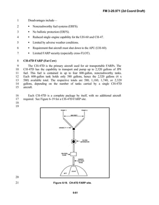
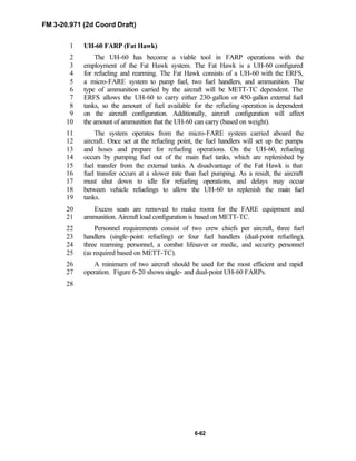
![FM 3-20.971 (2d Coord Draft)
6-66
located up to several kilometers away from the TOC. Communications1
between the GCS and the TOC is by landline or radio as provided by the2
supported unit.3
The TUAV platoon can also utilize the TROJAN SPIRIT tactical satellite4
system to send TUAV video over extended ranges or from locations where the5
area communications networks are immature. When the GCS is not located6
with the TOC, a remote video terminal (RVT) is placed in the TOC. The RVT7
is a receiver-only terminal that allows the supported commander to view the8
down-linked video from the TUAV. When the GCS is not collocated with a9
supported unit TOC, mission changes must be requested through the platoon10
headquarters via the supported unit to the GCS.11
Reporting is normally performed through voice or data messages detailing12
observed activity. Reports are produced in the GCS and sent to the ASAS or13
other consumers as directed. The report flow will be through normal14
intelligence reporting channels and will be in the size, activity, location, unit,15
time, and equipment (SALUTE) report format. This format is compatible with16
ASAS requirements and will facilitate correlation and dissemination. Imagery17
analysts at the brigade S2 perform detailed analysis of TUAV products as18
needed.19
LAUNCH AND RECOVERY SECTION20
The launch and recovery section is located at a site (road, soccer field, etc)21
suitable for the launch and recovery of the TUAVs. The section assembles22
and disassembles the air vehicle from storage containers. It performs the23
launch procedures for remote site rocket assist takeoff launches as well as24
normal launch preparation and recovery operations and maintenance of the25
runway areas and arresting cables.26
Launch and recovery must be from an area easily accessible to the27
commanders, with rapid set up and tear down times, enabling it to keep up28
with the brigade’s movement. To safely operate in the airspace within the29
brigade’s AO and interest, it is necessary to coordinate the use of the airspace30
and deconflict any potential problems with all other users and potential users.31
MAINTENANCE TEAM32
The maintenance team is collocated with the launch and recovery section.33
It is responsible for all major maintenance and repairs of the air vehicles,34
sensors, and support vehicles and generators. The team also performs normal35
fueling and defueling tasks as dictated by mission requirements.36
See FM 3-55.1 [FM 34-25-2] for addition information on the capabilities,37
limitations, tactics, techniques, and procedures of TUAV systems.38](https://image.slidesharecdn.com/fm-3-20-140723131053-phpapp02/85/Fm-3-20-97-the-recce_and_brt_troop_draft-370-320.jpg)
![FM 3-20.971 (2d Coord Draft)
6-67
SECTION V. MULTI-SENSOR PLATOON1
The multi-sensor platoon consists of a headquarters element and four2
IREMBASS/GSR sections, and four PROPHET sections (see Figure 6-22).3
The platoon depends on the ISR integration section located at the squadron CP4
for SIGINT mission management, technical support, and direction-finding5
analysis. See FM 2-00.21 [FM 34-2-1] or FM 3-20.96 [FM 17-96] for6
addition information on the capabilities, limitations, tactics, techniques, and7
procedures of IREMBASS, GSR and SIGINT systems.8
9
Figure 6-22. Multi-sensor platoon.10
HEADQUARTERS ELEMENT11
The platoon headquarters consists of a platoon leader and a platoon12
sergeant. The element is integrated into the platoon during tactical operations.13
They work together to ensure the subordinate sections are deployed,14
employed, and supported in accordance with the squadron operation order and15
the surveillance troop commander’s guidance. In accordance with standard16
troop-leading procedures, the platoon leader is responsible for coordinating17
the movement and link-up of platoon elements that the surveillance troop18
might attach to the recce troop.19](https://image.slidesharecdn.com/fm-3-20-140723131053-phpapp02/85/Fm-3-20-97-the-recce_and_brt_troop_draft-371-320.jpg)
![FM 3-20.971 (2d Coord Draft)
6-73
• Convex Baseline is a multi-station formation used when the threat1
forces are operating along a broad, deep front. This formation supports2
intercept coverage over a larger front, but not a precision location.3
• Concave Baseline is a multi-station formation used when the threat is4
operating in a compact, narrow but deep area like a salient. The5
direction-finding accuracy of this formation is excellent at short ranges6
and satisfactory at longer ranges.7
• Lazy-W Baseline is a multi-station formation that uses four or more8
systems and combines the characteristics of the convex and concave9
baselines. This formation is the most effective formation for situations10
where the location of threat or its main effort is unknown.11
In reconnaissance operations the PROPHET could be tasked to support12
forward reconnaissance patrolling. In these types of missions, the PROPHET13
would be primarily in an electronic support role to protect the patrolling assets14
and to provide possible electronic order of battle in support of the15
reconnaissance effort. Reconnaissance assets normally operate very slowly.16
The PROPHET would also operate very slowly and in a blackout condition.17
When a signal of interest is detected, the operator would note the essential18
elements of information, and depending on immediacy, the vehicle19
commander would report this information to the leader of the reconnaissance20
mission, or this information would be held until completion of the mission.21
The bottom line in this type of operation is that the PROPHET will operate22
very slowly either close to or across the FLOT in support of the23
reconnaissance effort.24
SECTION VI. IBCT INFANTRY RIFLE COMPANY25
26
NOTE: This section focuses on the newly formed IBCT infantry rifle27
company. Refer to FM 3-91.1 [FM 71-1] for information on the28
heavy brigade company/team organization and capabilities.29
30
The IBCT infantry rifle company’s mission is to close with the threat by31
means of fire and maneuver to destroy or capture him, or to repel his assault32
by fire, close combat, and counterattack. It is capable of executing any33
tactical mission, to include attack and defend, in close and urban terrain34
during an SSC or MTW operation and in a variety of stability operations or35
support operations.36
The infantry rifle company is employed primarily to defeat threat combat37
forces in close, complex, and urban terrain in an SSC. Its organic mobility,38](https://image.slidesharecdn.com/fm-3-20-140723131053-phpapp02/85/Fm-3-20-97-the-recce_and_brt_troop_draft-377-320.jpg)
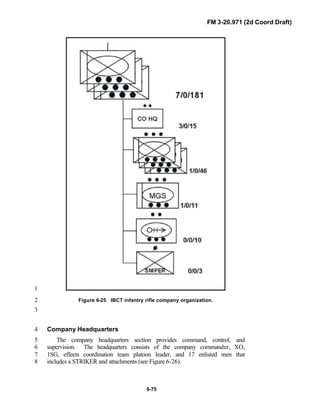
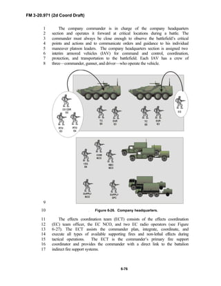
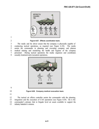
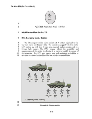
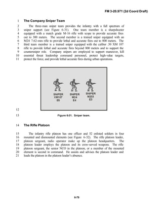
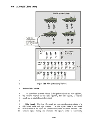
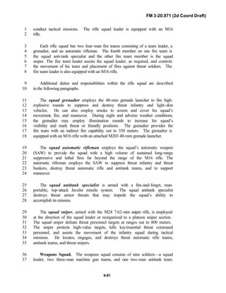
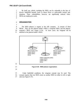
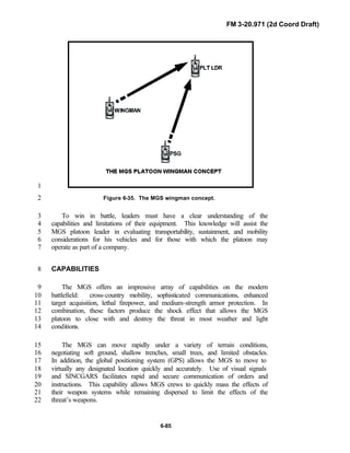
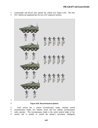
![FM 3-20.971 (2d Coord Draft)
6-93
The troop may be required to conduct NBC reconnaissance of routes or1
specific terrain features, using attached NBC reconnaissance sections.2
Security for this critical asset is always a concern, as is fratricide. Soldiers3
should always receive an FM warning when an NBC reconnaissance vehicle4
is entering their area.5
6
For detailed discussion of NBC operations, refer to FM 3-11.3 [FM 3-3]7
and FM 3-11.4 [FM 3-4].8
SECTION XI. IBCT ENGINEER COMPANY9
On order, as part of an SSC response, the engineer company rapidly10
deploys and provides mobility and force protection support to a medium11
combat brigade. On order and with augmentation, the company provides12
additional mobility (lines of communications), countermobility, survivability,13
and sustainment engineering support MTW and/or stability or support14
operations.15
CAPABILITIES16
The IBCT engineer company provides organic mobility, force protection,17
and topographic support to designated units within the brigade to include the18
RSTA squadron and recce troop. Limited countermobility, survivability, and19
sustainment engineering capability are made possible using the same force20
structure required for the mobility mission. The engineer company provides21
mobility support to mounted maneuver, dismounted assault, and urban22
operations. The company is equipped with reduction assets for existing,23
natural, and reinforcing obstacles in open rolling terrain, and in challenging24
complex and urban terrain. Lightweight bridging assets provide the brigade25
with enhanced mobility for limited dry- and wet-gap crossing. The26
company’s force protection capability reduces the brigade’s exposure to direct27
and indirect fires. Topographic capabilities assist the brigade in acquiring28
situational awareness. Limited countermobility assets enhance the brigade’s29
ability to preserve and protect friendly forces, to shape threat maneuver, and30
to gain, retain, or secure the positional advantage. The company’s limited31
survivability capability preserves the brigade’s combat power during assembly32
area and base camp operations and while in a transition to the defense.33
Limited sustainment capabilities provide the brigade with enhanced34
movement, maneuver, and force protection throughout the brigade area of35
responsibility. The engineer company has no dedicated reconnaissance assets,36
but with measured risk to organic mobility and force protection support, it can37
provide engineer reconnaissance teams to augment the RSTA squadron.38](https://image.slidesharecdn.com/fm-3-20-140723131053-phpapp02/85/Fm-3-20-97-the-recce_and_brt_troop_draft-397-320.jpg)
![FM 3-20.971 (2d Coord Draft)
6-97
organization that assures the freedom to maneuver on the battlefield within the1
combined-arms team framework. Its structure and operational characteristics2
enhance force momentum and lethality and increase the synchronization of3
engineer actions within the maneuver battle space. The company consists of a4
company headquarters, three combat mobility platoons, and a mobility5
support platoon. The company can be organized to operate as an engineer-6
pure element, or task organized with platoons supporting maneuver forces7
(see Figure 6-41). For a review of the engineer company in support of a8
heavy organization and capabilities, refer to FM 3-91.2 [FM 71-2].9
10
11
Figure 6-41. Engineer company organization.12
Engineer Company Headquarters13
The company headquarters commands and controls the unit’s tactical14
employment and administrative operations. The company headquarters15
includes the commander, operations officer (also known as the XO), 1SG,16
operations NCO, supply sergeant, NBC sergeant, two communications17
specialists, two drivers, and four combat medics. The communication18
specialists and the medics are task organized to provide support to the19
platoons. All additional CSS is required through the FSB or the supported20
maneuver forces to which engineers are tasked organized. This includes all21
classes of supply, maintenance, administrative, recovery, and area medical22
evacuation.23](https://image.slidesharecdn.com/fm-3-20-140723131053-phpapp02/85/Fm-3-20-97-the-recce_and_brt_troop_draft-401-320.jpg)
![FM 3-20.971 (2d Coord Draft)
6-98
Combat Mobility Platoon1
The combat mobility platoon is normally the lowest-level engineer unit2
that can effectively accomplish independent missions and tasks. It is a basic3
unit capable of maneuvering during combat operations, and it can fight as part4
of the engineer company or as part of the maneuver company/team. The5
combat mobility platoon consists of a platoon headquarters section and three6
eight-man combat engineer squads. On the battlefield, the platoon can7
facilitate rapid and frequent movement. It is capable of fighting, both8
mounted and dismounted, during various situations. The combat mobility9
platoon frequently receives augmentation in the form of special equipment10
from the mobility support platoon. With risk to mobility, engineer squads can11
be task organized for specific missions such as engineer reconnaissance12
missions. Specific platoon equipment includes IAV with mountable13
rollers/blades and associated engineer equipment, demolitions, and weapons.14
The eight-man sapper squad is the minimum force required to provide15
effective dismounted maneuver support.16
Mobility Support Platoon17
The mobility support platoon consists of a platoon headquarters section18
and three equipment-based mobility sections. Like the combat mobility19
platoon, the mobility support platoon is not organized to operate20
independently on the offense. Each section is structured for mobility missions,21
focused on reducing threat obstacles and fortifications that inhibit friendly22
maneuver. The platoon provides the commander with specialized equipment23
capabilities to weight the main effort. Each section has in-stride breaching,24
gap-crossing, lane-obstacle reduction capabilities as well as specialized25
vehicle-mounted tools and heavy blades. The same task organization and26
equipment required for mobility operations provide a limited capability for27
countermobility, survivability, and sustainment operations.28
29
30
SECTION XII. AIR DEFENSE31
Air defense actions include the passive and active measures employed by32
the troop to protect themselves from aerial attack. The commander must33
decide whether to engage threat aircraft (active air defense) based upon his34
assigned mission and the tactical situation. The following paragraphs are an35
overview of the passive and active air defense measures the troop may36
employ. Refer to FM 3-01.8 [FM 44-8] for further discussion on both passive37
and active air defense, and the techniques involved with each.38](https://image.slidesharecdn.com/fm-3-20-140723131053-phpapp02/85/Fm-3-20-97-the-recce_and_brt_troop_draft-402-320.jpg)
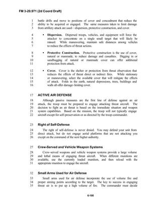
![FM 3-20.971 (2d Coord Draft)
7-2
SECTION I. UNDERSTANDING THE URBAN1
ENVIRONMENT2
3
Reconnaissance troops conduct multidimensional reconnaissance in urban4
environments to gain critical information for the brigade. Reconnaissance5
troops must have a clear understanding of their information requirements and6
how they relate to the higher headquarters intent and its approach to urban7
operations (see Figure 7-2).8
9
10
12
14
16
18
20
22
24
26
28
30
Figure 7-2. Infantry phase of urban operations.31
32
Crucial to planning urban operations is the urban IPB. Reconnaissance33
units must identify all relevant forces, their strengths and critical34
vulnerabilities, and identify the critical nodes of the urban area that may35
provide leverage if controlled. IPB must consider the impact of the36
noncombatants, whose presence in the urban area may be substantial and37
dynamic. Determining the ethnic and religious composition of the population,38
and if possible, their intent (to flee or remain in the urban areas) may prove39
crucial (see FM 2-01.3 [FM 34-130]).40
41
If combat operations in the urban environment are necessary, then the42
mission of the troop focuses on achieving informational and situational43
understanding for the brigade. Determining trafficability of routes and lateral44
routes, identifying subterranean entry points and systems, developing the45
communications architecture, and providing the framework for C2 are some46
of the tasks the troop may perform in shaping the battlefield for the brigade.47
48
Once the urban environment has been understood and shaped, the brigade49
can begin operations. Refer to the FM 3-91.3 [FM 71-3] for specifics on50
brigade framework for urban operations.51
52
Entering or operating within an urban environment poses a significant53
threat to the reconnaissance troop if proper planning and preparation are not54
INFANTRY PHASES OF URBAN OPERATIONS
Reconnoiter the Objective Phase.
Move to the Objective Phase.
Isolate the Objective Phase.
Secure a Foothold Phase.
Clear a Built-up Area Phase.
Consolidate Phase.
Reorganize Phase.](https://image.slidesharecdn.com/fm-3-20-140723131053-phpapp02/85/Fm-3-20-97-the-recce_and_brt_troop_draft-407-320.jpg)
![FM 3-20.971 (2d Coord Draft)
7-4
Buildings. Buildings provide cover1
and concealment, limit or enhance fields2
of fire, and restrict or block movement3
of ground forces. Rooftops must be4
considered a threat in themselves.5
Whenever possible, TUAV or aviation6
reconnaissance of rooftops should be7
used to identify threats, preempting8
threat contact. Scouts must identify9
buildings that serve as key terrain10
(communications node, dominant11
vantage points) throughout the urban area.12
13
Streets. Streets afford avenues of approach and are the primary means for14
rapid ground movement in an urban area. Forces traveling along streets,15
however, are often canalized by buildings and have little space for maneuver16
off the main thoroughfares. Scouts must identify trafficability of streets17
(lateral and parallel) within the AO. Width and weight capabilities of the18
streets must be determined throughout the urban area to assist follow on forces19
in their planning. These should be identified on the urban operations sketch20
(see Figure 7-4).21
22
23
24
25
Figure 7-3.26
27
28
Figure 7-4. Rubble effects in the urban area.29
30
Subterranean Systems. Subterranean systems can be easily employed as31
avenues of approach and supply routes for dismounted elements. Subways,32
sewers, cellars, and utility systems must be identified in order to understand33
how the threat may use them to conduct ambushes, counterattacks, infiltration,34
and sustainment operations. Entrances and exits to these areas should be35
mapped as part of an overlay for the urban operations sketch.36
37
The urban area is classified into six types of urban terrain as described in38
FM 2-01.3 [FM 34-130] (see Table 7-1).39
40
41
“Most of the buildings in the city
are equipped with concrete
basements,” said Zumrud Alieva,
52, a refugee who recently fled
Grozny. “We used to hide there
during the first war. Sometimes we
lived there for weeks. Many of the
cellars are equipped with a water
supply. We kept food stocks there
and some of the citizens even had
electric generators.”](https://image.slidesharecdn.com/fm-3-20-140723131053-phpapp02/85/Fm-3-20-97-the-recce_and_brt_troop_draft-409-320.jpg)
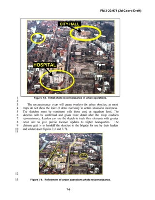
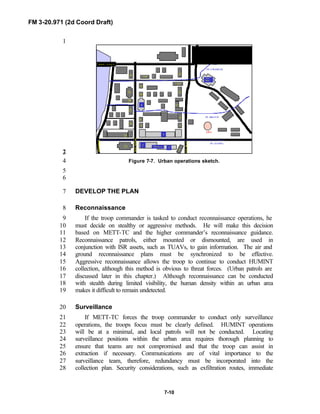
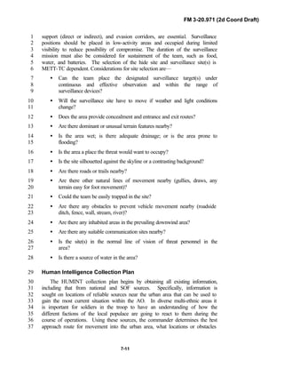
![FM 3-20.971 (2d Coord Draft)
7-19
1
2
3
4
5
6
7
8
9
10
11
NOTE: Refer to FM 3-20.98 [FM 17-98] for additional urban planning and12
reconnaissance TTPs.13
14
SECTION III. EXECUTION15
16
P Approach/enter the urban AO.17
P Employ surveillance teams (mounted/dismounted).18
P Conduct reconnaissance.19
P Assess the AO.20
21
APPROACH/ENTER THE URBAN AREA OF OPERATIONS22
The troop conducts reconnaissance and HUMINT collection (recce troop)23
outside of the urban area to gain information on the objective. Depending on24
the time available, the troop develops the urban situation progressively from25
the surrounding area toward the city. The commander refines objectives and26
routes as he gains and analyzes information (see Figure 7-8). If available,27
TUAVs or aerial reconnaissance assets are employed to conduct aerial28
reconnaissance of routes and objective areas. TUAVs are focused on unit29
entry points to determine the threat situation, such as obstacles in the urban30
area, ambush positions on rooftops, or movement of personnel and vehicles as31
units approach. As discussed earlier, the aerial and ground reconnaissance32
plans must be synchronized to be effective (see Figure 7-9).33
34
PLANNING PHASE CHECKLIST
ü Develop HUMINT collection plan.
ü Determine R&S objectives.
ü Plan infiltration and exfiltration routes.
ü Synchronize aerial and ground reconnaissance plans.
ü Develop communications and sustainment plan.
ü Coordinate for fire support.
ü Continue improving urban operations sketch.](https://image.slidesharecdn.com/fm-3-20-140723131053-phpapp02/85/Fm-3-20-97-the-recce_and_brt_troop_draft-424-320.jpg)
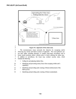
![FM 3-20.971 (2d Coord Draft)
7-25
Urban Patrolling1
Reconnaissance troops will not normally perform building-to-building2
clearing in urban areas. However, they may perform urban patrolling to3
accomplish reconnaissance missions. As discussed previously, detailed4
planning is accomplished prior to execution of a patrol. Using maps, aerial5
photography, and any known intelligence, leaders will determine the6
following:7
• Preliminary route reconnaissance.8
• Insertion and extraction routes.9
• Choke points along the routes.10
• Escape and evasion directions or corridors.11
12
Urban patrols may be conducted mounted or dismounted with vehicles13
supporting. Patrols should never be conducted lower than section level.14
15
NOTE: For detailed discussion on employment methods of dismounted and16
mounted reconnaissance in urban terrain, see FM 3-20.9817
[FM 17-98], Chapter 7.18
19
Mounted Patrolling20
Mounted patrols capitalize on the mobility of the unit’s vehicles. Mounted21
urban patrolling principles include the following:22
• Ensure mutual support and depth by maintaining constant observation23
among vehicles.24
• Coordinate a supporting fire plan with any dismounted units in the25
area.26
• Maintain all-around security.27
• Develop a reliable communications plan for mounted and dismounted28
elements.29
• Adjust patrol routes and speed to promote deception and avoid30
repetitive patterns.31
• Maintain situational awareness.32
33
Mounted patrols never enter an area via the route they will use to exit it34
(see Figure 7-10). Vehicles should travel at moderate speeds, with the lead35
vehicle stopping only to investigate those areas that pose a potential threat or36
support the essential tasks of the patrol. Use a vehicle speed of 15 to 20 miles37
per hour to allow for adequate observation and quick reaction. Slower speeds38](https://image.slidesharecdn.com/fm-3-20-140723131053-phpapp02/85/Fm-3-20-97-the-recce_and_brt_troop_draft-430-320.jpg)
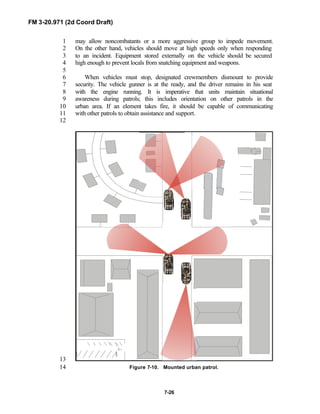
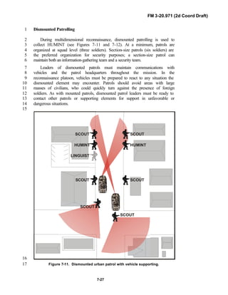
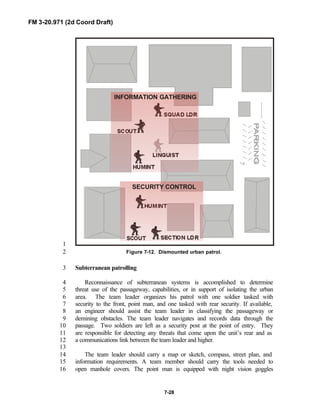
![FM 3-20.971 (2d Coord Draft)
8-4
purification, mortuary affairs support, airdrop support, laundry and1
shower services, and clothing and light textile repair.2
3
FM 3-0 [FM 100-5] and FM 4-0 [FM 100-10] discuss these functions in4
detail.5
6
7
CSS CHARACTERISTICS8
9
Sustainment enables the troop commander to accomplish the wide range10
of tasks he may be assigned. The logistics tail must not needlessly inhibit the11
operations of the squadron/troop. To meet this challenge, CSS leaders are12
guided by the following five imperatives when planning or executing:13
• Anticipation.14
• Integration.15
• Continuity.16
• Responsiveness.17
• Improvisation.18
19
Anticipation20
21
CSS leaders must not only support the ongoing operation, but also22
anticipate future events and requirements. The troop XO and 1SG must23
anticipate the needs of the unit as an operation is occurring, coordinate to push24
support forward, keep the commander abreast of CSS status and capabilities,25
and keep the support echelons informed of requirements. If CSS becomes26
reactive, support will be too late. The XO and 1SG, in conjunction with the27
S4, must immediately begin planning when he receives the warning order and28
FRAGOs. He must determine support requirements, coordinate changes to29
support relationships, and alert the supporting units to new trains positions to30
maintain the flow of support.31
32
Integration33
34
Commanders and staffs must integrate CSS into the planning process. At35
troop level, the commander, XO, and 1SG perform this function. At squadron36
level, the S4 has staff responsibility and works with the squadron commander,37
XO, S3, and HHT commander, and the brigade support battalion staff to38
ensure integration occurs. CSS leaders must identify sustainment problems39
during the estimate process and before the operation starts. Discussing CSS in40
maneuver and in fire support rehearsals is a highly recommended method to41
ensure the CSS plan is integrated and all planners and executors outside of the42
CSS arena (commanders, battle captains, S2, etc) know of the plan.43
44
45](https://image.slidesharecdn.com/fm-3-20-140723131053-phpapp02/85/Fm-3-20-97-the-recce_and_brt_troop_draft-441-320.jpg)
![FM 3-20.971 (2d Coord Draft)
8-5
Continuity1
2
Sustainment efforts are continuous. CSS is never in reserve. Support is3
continuous during preparations before an operation begins, during the4
operation, and afterwards as the troop reconstitutes or prepares for another5
mission. Operator and organizational maintenance and repair work is done6
whenever the opportunity exists. Repairing and returning damaged equipment7
to the fight requires early diagnosis and identification of faults and is done as8
far forward as possible. Immediate resupply is conducted when needed, but9
routine resupply (LOGPAC) is the standard. Vulnerability and limited cross-10
country mobility of CSS vehicles dictate the predominant use of road and trail11
networks. Continuous CSS operations require careful personnel management12
to provide sustained effort. Local security, routine details, and operator13
maintenance all compete for time with CSS operations. Fatigue can quickly14
degrade the effectiveness of soldiers who must simultaneously provide15
continuous support to the squadron and maintain their own equipment.16
Carefully planned and strictly enforced rest plans help to ensure continuous17
support.18
19
Responsiveness20
21
Responsiveness is the ability to meet changing or unforeseen requirements22
on short notice. The CSS system must be as agile as the maneuver system to23
allow the commander to successfully seize opportunities or exploit tactical24
success.25
26
Improvisation27
28
Improvising is essential as CSS leaders seek to solve significant, often29
unanticipated problems. These problems may be caused by threat action30
against the support system, mass casualties and destruction of maneuver31
assets, environmental conditions of the area of operations, or disruptions of32
command and control. Normal operating procedures may be suspended and33
extraordinary measures taken to overcome the problem. Agility, initiative,34
and ingenuity on the part of CSS leaders are essential.35
36
These imperatives should be encompassed in SOPs as they establish the37
focus for organization and operations of the CSS system. FM 3-0 [FM 100-5]38
and FM 4-0 [FM 100-10] provide background on these imperatives.39
40
41
42](https://image.slidesharecdn.com/fm-3-20-140723131053-phpapp02/85/Fm-3-20-97-the-recce_and_brt_troop_draft-442-320.jpg)
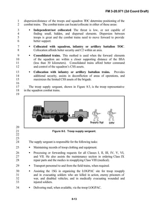
![FM 3-20.971 (2d Coord Draft)
8-14
At the squadron combat trains, the supply sergeant coordinates with the S41
and the squadron field trains (located in or near the BSA) via radio, FBCB2,2
or GCCS-A to ensure the LOGPAC meets the troop’s CSS requirements. The3
squadron’s LOGPAC meeting serves to coordinate the requirements for the4
next LOGPAC.5
The supply sergeant coordinates with the S4 for parts and maintenance6
and with the squadron personnel and administration center (PAC) section for7
mail, promotions, awards, Standardization Installation/Division Personnel8
System (SIDPERS), and other personnel actions. The supply sergeant must9
frequently check with the HHT command post in the field trains for any10
additional troop requests reported on the A/L net.11
The squadron combat trains is responsible for its own local security. The12
supply sergeant will be tasked to assist the S4 in maintaining security of the13
combat trains. He must execute and supervise security operations in14
accordance with the S4’s plan. During the movement through nonsecure areas,15
the supply sergeant should ensure that all crew-served and individual weapons16
are manned and ready. He should also ensure that all members of the troop17
combat trains are briefed on immediate action drills for threat contact or18
vehicle breakdowns.19
20
Squadron Field Trains21
22
The squadron field trains is the primary direct coordination element23
between the squadron and the BSA. The field trains may collocate with the24
BSA, operate independently between the BSA and combat trains, collocate25
with the squadron trains, or with the nearest trains of the infantry battalions.26
Field trains location is determined by the level and capabilities of the threat27
and the distances between the forward elements of the squadron and the BSA.28
The field trains will normally consist of the HHT commander, XO, 1SG, NBC29
NCO, and supply sergeant. The field trains ensure the LOGPACs are30
organized and configured per the unit’s requests and that the LOGPAC makes31
it forward, at a minimum, to the combat trains and back to the BSA.32
33
34
COMBAT SERVICE SUPPORT TO THE RECONNAISSANCE35
TROOP36
37
The BRT has no organic logistics capability and requires detailed planning38
for support by the brigade staff. The brigade support company (BSC) of the39
FSB normally supports the BRT. If the situation permits, the BSC pushes40
assets forward to designated LRPs to meet the BRT’s needs. Alternately, the41
brigade assigns subordinate task forces the responsibility to support the42
logistics requirements of the troop. Reference FM 3-91.3 [FM 71-3] for the43
capabilities and organization of the brigade’s CSS assets. Regardless of the44](https://image.slidesharecdn.com/fm-3-20-140723131053-phpapp02/85/Fm-3-20-97-the-recce_and_brt_troop_draft-451-320.jpg)
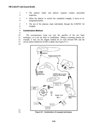
![FM 3-20.971 (2d Coord Draft)
8-23
At the end of the resupply operation, the troop LOGPAC returns to the1
LRP to link up with the representative (combat or field trains representative)2
who led the LOGPAC forward, and returns to the BSA.3
4
Aerial Resupply5
6
Helicopters can be a vital lifeline when reconnaissance troops are forced7
to operate forward of friendly lines for extended periods. Aerial resupply8
operations may reduce the risks associated with conducting ground resupply9
operations under such conditions; however, they require significant planning10
and entail a different set of risks to consider. Aerial assets are also useful in11
resupplying dismounted reconnaissance troops in OPs in restricted terrain. On12
the other hand, aerial resupply sometimes will not be feasible because13
helicopters are not available. In addition, the signature of resupply helicopters14
can compromise troop positions. Careful choice of resupply routes and15
landing zones helps to minimize this risk. See FARP Operations paragraph in16
Chapter 6, Section III, for more information on aerial resupply.17
18
Troop Prestock or Cache19
20
Resupply techniques; also called prestock resupply, differ in the level of21
security provided for the supplies. In pre-positioning, supplies are generally22
left unattended, without security, although steps should be taken to prevent23
detection of the location by threat elements. When the unit resupplies by24
cache, it should leave security personnel to guard the site.25
26
Both pre-positioning and cache can be used in a variety of reconnaissance27
or security operations. During reconnaissance, prestock positions can be28
established along the intended route of advance or near the objective by29
advance elements. In security operations, the reconnaissance platoon can set30
up prestock points throughout the area of operations. These points should be31
in each alternate or supplementary OP, in addition to other locations32
throughout the depth of the sector. Scouts can also use prestock to provide33
resupply for patrols.34
35
Prestock operations must be carefully planned and executed at every level.36
Prestock points should be placed where they can be located by simple37
instructions that are clear to someone who has never visited the site. All38
leaders, down to vehicle commander and squad leader, must know the exact39
locations of prestock points. As noted, the troop CSS team must take steps to40
ensure security and survivability of pre-positioned supplies by digging in41
prestock positions, selecting covered and concealed positions, and considering42
the effects of weather and terrain. The CSS team must also have a plan to43
remove or destroy prestock supplies to prevent the threat from capturing them.44
45
NOTE: Refer to FM 3-20.98 [FM 17-98] for additional information.46](https://image.slidesharecdn.com/fm-3-20-140723131053-phpapp02/85/Fm-3-20-97-the-recce_and_brt_troop_draft-460-320.jpg)
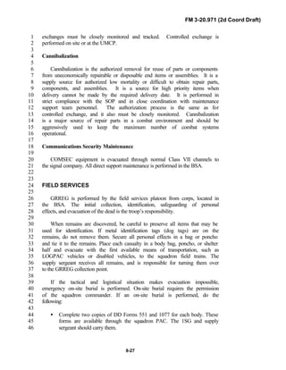
![FM 3-20.971 (2d Coord Draft)
A-3
Copy _____ of _____copies1
Issuing headquarters2
Place of issue3
Date-time group of signature4
Message reference number5
6
OPERATION PLAN (ORDER)____________(code name)7
(number)8
References: What map sheet, charts, datum, or other documents are required to understand the order.9
Time Zone Used Throughout the Plan (Order): Use Zulu for operations spanning more than10
one time zone.11
* Task Organization: One level down pure, task organize two levels down. Include BOS that are task12
organized; i.e., engineer, ADA, and intel assets (see example below). List major systems. Ensure units13
are sequenced properly: type, size, numerically, alphabetically.14
* Task Organization Effective (DTG):15
* Squadron Task Organization Example:16
* Terrain and Weather: Post MCOO over higher’s graphics. MCOO must contain: Obstacles17
(manmade and natural), restricted and severely restricted terrain, key terrain, avenues of approach (AA)18
and mobility corridors (MC), unit boundaries.19
(a) Terrain: OAKOC F and E, REF 1: 50 map with AO/AI identified, using higher’s graphics. Refer20
to21
FM 2-00.21 [FM 34-2-1].22
* The terrain favors__________.23
* Obstacles: What are they: severely restricted, restricted, manmade, natural, and dirty24
battlefield. Obstacles identify MCs, which identify AAs. Name cities, major roads, and25
rivers.26
- F: Effects of foot, wheeled, and tracked movement.27
- E: Effects of foot, wheeled, and tracked movement.28
- C:29
* Avenues of Approach/Mobility Corridors: State up front: There are ___ AAs in30
our AO. What are they: number them by priority, ground (mounted and dismounted), and air.31
Enemy (Threat) AAs are red and friendly AAs are blue.32
- Avenues of Approach: One level down; discuss the size force it can support.33
- Mobility Corridors: Two levels down; discuss the size force it can support, linkage34
to AA or bypass; i.e., MC #1 is a ___ size MC that runs North to South and links AA1 to35
AA2.36
- Air AA: Fixed or rotary wing, or TUAV.37
* Key Terrain: There are ____ pieces of key terrain in our AO. What are they: circle with38
a purple K and number them by priority of importance. Describe the facts of each and how39
each affects friendly and enemy:40](https://image.slidesharecdn.com/fm-3-20-140723131053-phpapp02/85/Fm-3-20-97-the-recce_and_brt_troop_draft-472-320.jpg)

![FM 3-20.971 (2d Coord Draft)
A-5
* Cover/Concealment: How is it; discuss along AAs or in BPs.1
- F:2
- E:3
(b) Weather: Describe weather and its effects. Ref MCOO placed over ops map. Discuss use of4
smoke, NODs, chemical, and fog and how they will affect recon, surveillance, and air operations.5
Refer to6
FM 2-00.21 [FM 34-2-1].7
* The weather favors__________.8
* Visibility/Illum:What is it: use of nods, fog facts.9
- F:10
- E:11
* Wind speed and direction: What is it: smoke, chemical, and dust.12
- F:13
- E:14
* Precipitation: What is it: smoke, chemical, dust, streams.15
- F:16
- E:17
* Cloud Cover: What is it: air.18
- F:19
- E:20
* Temp and humidity: What is it: smoke, chemical, fog.21
- F:22
- E:23
* Other: Reference the weather/light data chart24
DATE
SUN
RISE
SUN
SET EENT BMNT
MOON
RISE
MOON
SET
MOON
PHASE
%
ILLUM TEMP HUMID
1. SITUATION: Post higher’s SITEMP with higher’s graphics.25
a. Enemy (Threat) Forces: SITEMPs include: firesack, OPs, main body, reserves (CAR, AT,26
tank) with routes and time-phase lines, indirect fire assets, obstacles in green, key weapon system27
ranges, AAs (ground and air), CATK routes, unit positions, paramilitary forces, terrorists. Refer28
to FM 2-00.21 [FM 34-2-1] for ROM.29
(1) Threat Activity Overview (how he got there): Ref SITEMP, mission, current30
activity (the big picture). State the size and type of unit(s).31
(2) Disposition (Fact): Post your most probable COA SITEMP. Intelligence has confirmed32
the following locations (must have a grid): (offense = TAA; defense = basic force array of33
confirmed locations, units, and anything else confirmed). State the generic size (no numbers)34
of the unit, if known. Refer to SITEMP.35](https://image.slidesharecdn.com/fm-3-20-140723131053-phpapp02/85/Fm-3-20-97-the-recce_and_brt_troop_draft-474-320.jpg)
![FM 3-20.971 (2d Coord Draft)
A-6
THREAT PHASES IN OFFENSE
*Fire support for the movement
forward.
*Fire Preparation for the attack.
*Fire support of the attack.
*Fire Accompaniment (Attack into the
depth).
THREAT PHASES IN DEFENSE
*Fire interdiction.
*Fire to repel enemy attack.
*Fire support of defending troops.
*Fire destruction of threat counter
attack.
(3) Composition (Fact): The _____ is at _____ % strength. The threat force we are facing1
is T-80 / BMP2-equipped at 80% strength. Refer to the Threat Forces Available Chart or2
look in the order for a smaller version of the Threat Forces Available Chart. I will give you a3
minute to review that; later I will brief the most probable COA task organization.4
ELEMENT SYMBOL SYSTEM WPN / RANGE
(4) Capabilities / Limitations:5
(5) Threat most probable COA (how you think he will fight [best guess]):6
(a) The general pattern of his operation is: discuss his force array in the7
order that the BLUEFOR will see them.8
(b) The _____ is task organized with ______ (refer to the Threat most9
probable COA Task Organization Chart: As you move through the elements, identify their10
location on the map and then give the system and characteristics.11
ELEMENT SYMBOL SYSTEM WPN / RANGE
(c) The threat’s most probable COA statement is:12
* Phase 1:13
- Observation:14
- Indirect:15
- Obstacles:16
- Direct:17
- Air:18
- Chemical:19
- Reserves:20
* Repeat this same process for each of the threat’s four phases:21
Tell your subordinates one level down exactly what they will see and give task,22
purpose, and location x 2 for each threat element. Include discussion of the23
movement of his HVTs, triggers, and threat’s decision points. The paragraphs are24
broken down within the threat four phases of indirect fire, which is the logical25
sequence of events that we would see, by OIODACR. Refer to SITEMP. What is26
confirmed (solid lines) and suspected (dashed lines) is discussed. Reserve location27
and commitment criteria. Use correct symbology. Discuss immediate and28
subsequent objectives and discuss time/distance factors. Ensure you discuss obstacle29
belts, MOD, and the MSD.30
(6) Threat Decision Points / Triggers.31
The Threat COA will change as the mission
continues.
Refer to the timeline that contains both
friendly and threats actions on it. Blue =
Friendly and Red = Threat.
Sequence of Enemy Contact = OIODACR
(observation, indirect, obstacles, direct,
air, chemical, reserves)](https://image.slidesharecdn.com/fm-3-20-140723131053-phpapp02/85/Fm-3-20-97-the-recce_and_brt_troop_draft-475-320.jpg)

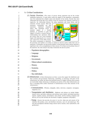
![FM 3-20.971 (2d Coord Draft)
A-9
- Commerce. (Area includes business and financial centers (stores, shops, restaurants,1
marketplaces, banks, trading centers, and business offices) and outlying2
industrial/agricultural features [strip malls, farms, food storage centers, and mills], as well3
as environmentally sensitive areas [mineral extraction areas and chemical/biological4
facilities].)5
- Human services. (Include hospitals, water supply systems, waste and hazardous6
material storage and processing, emergency services [police, fire, rescue, and emergency7
medical services], and governmental services [embassies, diplomatic organizations,8
management of vital records, welfare systems, and the judicial system]. The loss of any of9
these often has an immediate, destabilizing, and life-threatening impact on the10
inhabitants.)11
(3) Negative Effects:12
- Food and water shortages.13
- Refugees.14
- Urban elite (groups that carry more power than the local or state government and have15
major power over the areas politics and economic activities).16
- Disease and pollution.17
- Insurgencies.18
- Crime.19
c. Friendly Forces: Orient, read, and reference.20
(1) Two levels higher mission:21
(2) Two levels higher intent:22
(3) Two levels higher concept of the operation:23
(4) One level higher mission:24
(5) One level higher intent:25
(6) Commander’s reconnaissance guidance (focus, tempo, engagement criteria):26
(7) One level higher concept of the operation:27
(8) Flank Units T and P: Units that have a bearing on the issuing headquarters. Identify28
using cardinal directions.29
(9) Reserve Unit: Purpose and any planning guidance and any be-prepared missions/tasks.30
d. Units Supporting Higher Headquarters:31
e. Attachments / Detachments: When not addressed in task organization, by phase.32
2. MISSION: who, what, where, when, why. No more than two o/o missions. Reference graphics.33
3. EXECUTION: Squadron and below has one main effort per mission. O/O can change.34
* Commander’s Intent: Key tasks, purpose (?), and end state.35
* Key Tasks: Those that must be performed or conditions that must be met to achieve the36
purpose. Not tied to a specific COA. The operation’s tempo, duration, effect on the threat, and37
terrain that must be controlled are examples of key tasks.38
* Broader Purpose, if needed, to expand on the purpose in the mission statement.39](https://image.slidesharecdn.com/fm-3-20-140723131053-phpapp02/85/Fm-3-20-97-the-recce_and_brt_troop_draft-478-320.jpg)
![FM 3-20.971 (2d Coord Draft)
A-19
1
C2 locations
by Phase:
Give Grids
C2 Assets
PHASE I PHASE II PHASE III PHASE IV PHASE V REMARKS
CDR
TOC
TAC
HIGHER CDR
RETRANS
b. Signal:2
- SOI ___ in effect.3
- GPS time in effect.4
- COMSEC guidelines and radio communications restrictions.5
- Code words.6
- Visual and Pyrotechnic Signals: For example, red smoke marks the7
friendly line of own troops for CAS.8
- Methods of communication by priority.9
- Freq time changes.10
- Retrans in effect:11
- Day 1 Challenge _____, Day 1 Password _____.12
- Day 2 Challenge _____, Day 2 Password _____.13
- Day 3 Challenge _____, Day 3 Password _____.14
- Hopset series_____.15
- Radio Frequencies: as needed.16
- Required reports, formats, and time to submit.17
- Review issues / notes:18
- Time now:_____: Sync watches.19
- Backbriefs in 15 minutes.20
- Next hard time.21
- Questions.22
23
ACKNOWLEDGE: Instructions for the acknowledgment of the plan or order by addresses.24
25
NAME (Commander’s last name)26
RANK (Commander’s rank)27
(Original signed; copy remains in the HQ file)28
OFFICIAL: If not signed by the commander, authentication is required by the preparing staff officer29
(name and position).30
ANNEXES: (Doctrinal reference FM 5-0 [FM 101-5].)31](https://image.slidesharecdn.com/fm-3-20-140723131053-phpapp02/85/Fm-3-20-97-the-recce_and_brt_troop_draft-488-320.jpg)
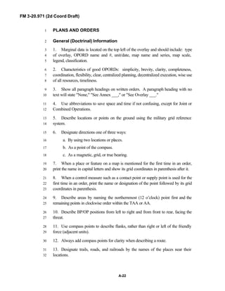
![FM 3-20.971 (2d Coord Draft)
B-1
APPENDIX B1
NUCLEAR, BIOLOGICAL, AND CHEMICAL2
OPERATIONS3
4
Because many potential adversaries have the capability to employ biological,5
chemical, and nuclear weapons, scouts must prepare to fight in an NBC6
environment. Collecting, processing, and disseminating needed NBC hazard7
information is also vital. To survive and remain effective on the integrated battlefield,8
the reconnaissance troop must be proficient in the three fundamentals of NBC9
defense: contamination avoidance, NBC protection, and decontamination.10
Additional-duty NBC personnel should be designated by the platoon SOP for11
operations in an NBC environment. The crews of the section leaders’ vehicles12
should be designated and trained as chemical agent detection and radiological13
survey and monitoring teams. The squad leaders’ crews should be designated as14
decontamination teams and trained to operate all decontamination equipment15
organic to the brigade or squadron.16
NOTE: See FM 3-20.98 [FM 17-98] for more detailed information on NBC17
procedures and equipment.18
19
CONTENTS20
Page21
SECTION I. Contamination Avoidance..............................................B-122
SECTION II. NBC Protection...............................................................B-423
SECTION III. Symptoms and Treatment of NBC Casualties.................B-824
SECTION IV. Marking Contamination..................................................B-1025
SECTION V. Decontamination............................................................B-1326
SECTION VI. Reconnaissance and Surveillance in an27
NBC Environment........................................................B-1528
29
30
SECTION I. CONTAMINATION AVOIDANCE31
32
Avoidance is the most important fundamental of NBC defense because the best33
way to survive is to avoid being the object of an NBC attack. Avoiding34
contaminated areas minimizes the risk of additional casualties and the degradation of35](https://image.slidesharecdn.com/fm-3-20-140723131053-phpapp02/85/Fm-3-20-97-the-recce_and_brt_troop_draft-494-320.jpg)
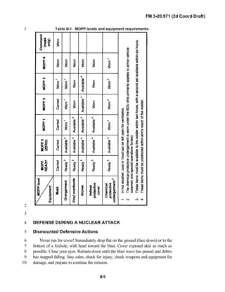
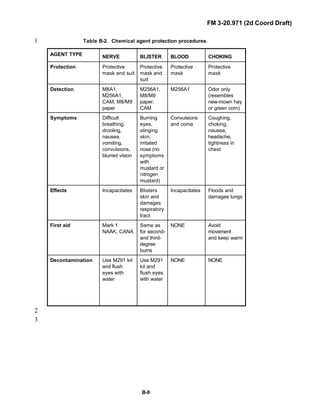
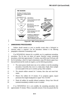
![FM 3-20.971 (2d Coord Draft)
B-13
SECTION V. DECONTAMINATION1
Since continued operation in the presence of nuclear or chemical contamination2
will cause casualties and severe combat degradation, decontamination is essential.3
To get the maximum benefit of the time and resources available, the scout platoon4
should conduct decontamination using the following guidelines:5
• Conduct it as soon as possible.6
• Conduct it only to the extent necessary to ensure safety and operational7
readiness.8
• Conduct it as far forward as possible.9
• Conduct it by priority.10
These principles are consistent with doctrine that places the burden of11
decontamination at battalion or troop level. For this reason, the scout platoon must12
use all of the available decontamination assets to maximum benefit and develop a13
thorough SOP covering decontamination methods and priorities. Refer to FM 3-14
11.5 [FM 3-5] for more detailed information on NBC decontamination.15
IMMEDIATE DECONTAMINATION16
Immediate decontamination is a basic soldier survival skill carried out by17
soldiers as soon as possible after they discover they are contaminated. Its basic18
purposes are to minimize casualties, save lives, and limit the further spread of19
contamination. Any contact between chemical or biological agents and bare skin20
should be treated as an emergency. Some agents can kill if they remain on the skin21
for longer than a minute. The best technique for removing or neutralizing these22
agents is to use the M291 skin decontamination kit. Leaders must ensure that their23
soldiers are trained to execute this technique automatically, without waiting for24
orders.25
Personal wipedown should begin within 15 minutes of contamination. The26
wipedown removes or neutralizes contamination on the hood, mask, gloves, and27
personal weapon. For chemical and biological contamination, soldiers use mitts28
from the M295 individual equipment decontamination kit (IEDK). For radiological29
contamination, they wipe off the contamination with a cloth or simply brush or shake30
it away.31
Operator’s spraydown of equipment should begin immediately after completion32
of personal wipedown. The spraydown removes or neutralizes contamination on the33
surfaces operators must touch frequently to perform their mission. For chemical and34
biological contamination, operators can use on-board decontamination apparatuses,35
such as the M11/M13, or the M295 IEDK to decontaminate surfaces to which36
DS2 cannot be applied. (NOTE: DS2 must be washed off surfaces no more than37](https://image.slidesharecdn.com/fm-3-20-140723131053-phpapp02/85/Fm-3-20-97-the-recce_and_brt_troop_draft-506-320.jpg)
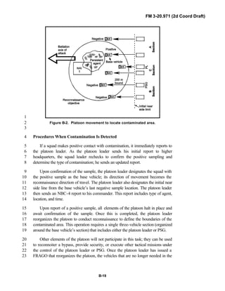
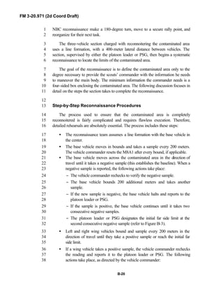
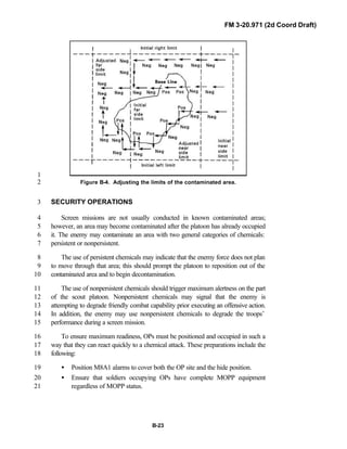
![FM 3-20.971 (2d Coord Draft)
C-1
APPENDIX C11
FORCE PROTECTION22
33
Force protection is one of the four primary elements that combine to create44
combat power. The primary objective of force protection is to help units protect55
their combat power through accident prevention, enabling them to win the battle66
quickly and decisively, with minimum losses. This appendix will focus on two77
aspects of force protection, safety or risk management, and the avoidance of88
fratricide. Risk is the chance of injury or death for individuals and damage to or loss99
of vehicles and equipment. Risks, and/or the potential for risks, are always present1100
in every combat and training situation the recce troop faces. Risk management must1111
take place at all levels of the chain of command during each phase of every1122
operation; it is an integral part of all tactical planning. The recce troop commander,1133
his platoon leaders, his NCOs, and all other soldiers must know how to use risk1144
management, coupled with fratricide reduction measures, to ensure that the mission1155
is executed in the safest possible environment within mission constraints. For1166
additional information on risk management, refer to FM 3-100.14 [FM 100-14].1177
1188
1199
CONTENTS2200
Page2211
SECTION I. Risk Management ........................................................... C-12222
SECTION II. Fratricide ........................................................................ C-72233
2244
2255
2266
SECTION I. RISK MANAGEMENT2277
2288
This section outlines the five steps of risk management. Leaders in the recce2299
troop must always remember that the effectiveness of the process depends on3300
situational awareness. They should never approach risk management with “one size3311
fits all” solutions to the hazards the troop will face. Rather, in performing the steps,3322
they must keep in mind the essential tactical and operational factors that make each3333
situation unique.3344
STEP 1 – IDENTIFY HAZARDS3355
A hazard is a source of danger. It is any existing or potential condition that3366
could entail injury, illness, or death of personnel; damage to or loss of equipment3377
and property; or some other sort of mission degradation. Tactical and training3388
operations pose many types of hazards.3399](https://image.slidesharecdn.com/fm-3-20-140723131053-phpapp02/85/Fm-3-20-97-the-recce_and_brt_troop_draft-518-320.jpg)
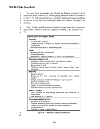
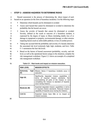
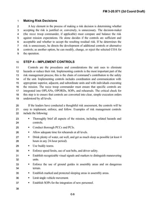
![FM 3-20.971 (2d Coord Draft)
C-8
Added to this is the problem of battlefield obscuration, which becomes a critical11
consideration whenever thermal sights are the primary source of target identification.22
Rain, dust, fog, smoke, and snow degrade identification capability by reducing the33
intensity and clarity of thermal images.44
55
On the battlefield, positive visual identification cannot be the sole engagement66
criteria at ranges beyond 1,000 meters. Situational awareness is the key; it must be77
maintained throughout an operation.88
99
1100
RISK IDENTIFICATION AND PREVENTIVE MEASURES1111
Reduction of fratricide risk begins during the planning phase of an operation and1122
continues throughout preparation and execution. Risk identification must be1133
conducted at all levels during each phase, and the results clearly communicated up1144
and down the chain of command so risk assessment can begin. This section covers1155
considerations that influence risk identification; it also focuses on measures the troop1166
commander can implement both to make the identification process more effective1177
and to help prevent friendly fire incidents from occurring.1188
1199
Planning Phase2200
A plan that is thoroughly developed and understood helps to minimize fratricide2211
risk. The following considerations help indicate the potential for fratricide in a given2222
operation:2233
• The clarity of the enemy situation.2244
• The clarity of the friendly situation.2255
• The clarity of the commander’s intent.2266
• The complexity of the operation.2277
• The planning time available at each level.2288
2299
Graphics are a basic tool that commanders at all levels use to clarify their intent,3300
add precision to their concept, and communicate their plan to subordinates. As3311
such, graphics can be a very useful tool in reducing the risk of fratricide.3322
Commanders at all levels must understand the definitions and purpose of operational3333
graphics and the techniques of their employment.3344
3355
NOTE: See FM 6-99.1 [FM 101-5-1] for the definitions of each type of graphic3366
control measure.3377
3388
Preparation Phase3399](https://image.slidesharecdn.com/fm-3-20-140723131053-phpapp02/85/Fm-3-20-97-the-recce_and_brt_troop_draft-525-320.jpg)
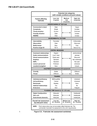

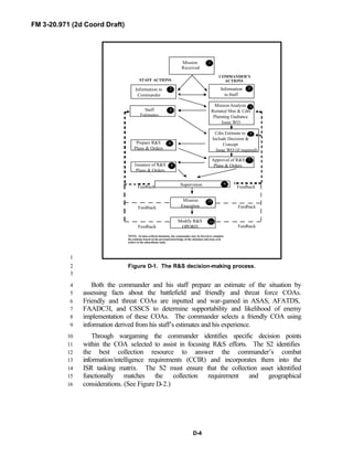
![FM 3-20.971 (2d Coord Draft)
D-5
1
Figure D-2. CCIR linkage (Draft picture).2
3
A detailed discussion of the decision-making process is outlined in4
FM 5.0 [FM 101-5]. The staff estimates discussed in FM 5.0 [FM 101-5]5
should be reviewed and the processes incorporated into digital procedures to6
speed and enhance the wargaming, COA development and decision-making7
processes.8
9
SECTION III. INTELLIGENCE PREPARATION OF THE10
BATTLEFIELD11
12
13
IPB is a systematic, continuous process of analyzing the effects of the14
threat and the environment on the unit. It is a dynamic process, driven by the15](https://image.slidesharecdn.com/fm-3-20-140723131053-phpapp02/85/Fm-3-20-97-the-recce_and_brt_troop_draft-535-320.jpg)
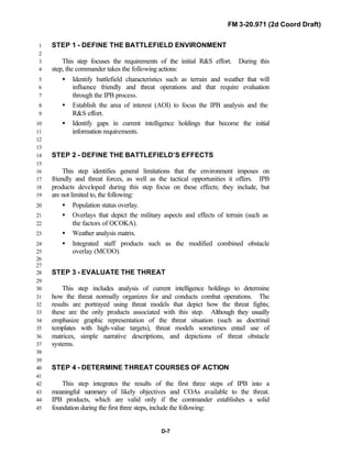
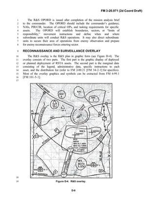
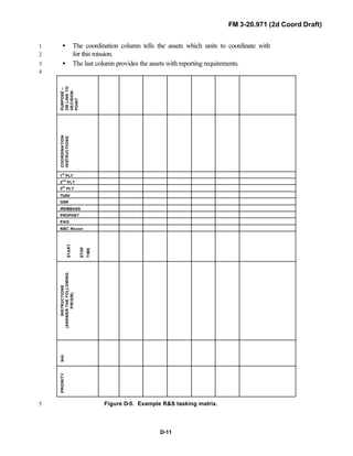
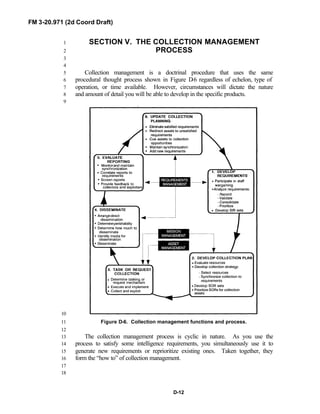
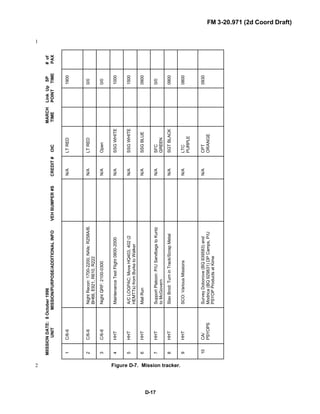
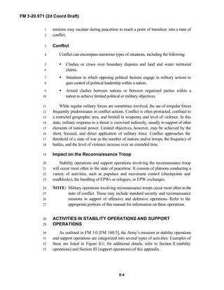
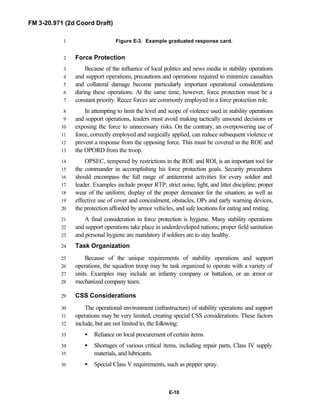
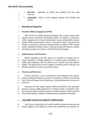
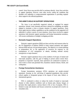


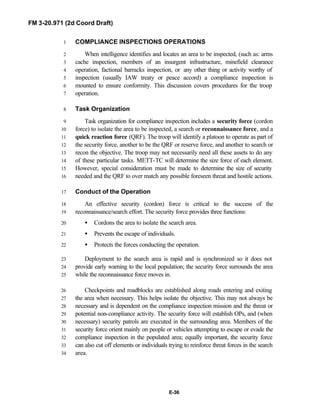
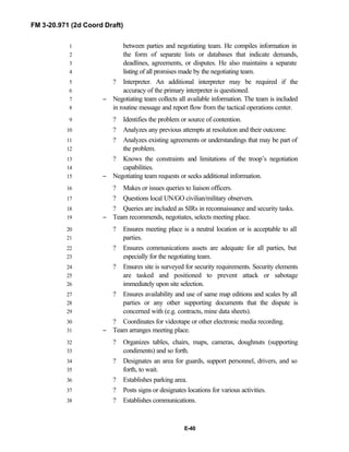
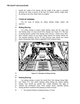
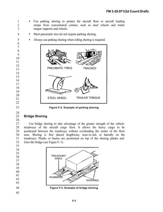
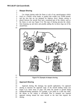
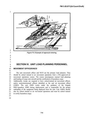
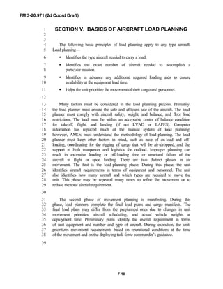

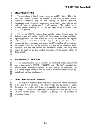
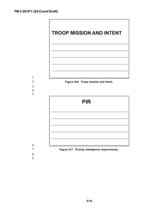
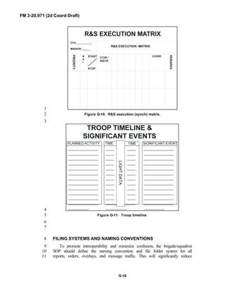
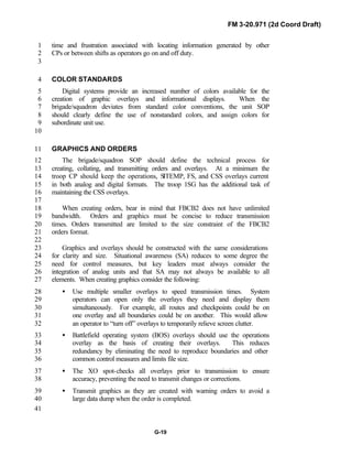

This document provides an overview of the operational environment and organizations of reconnaissance troops. It describes the six dimensions that comprise the operational environment - threat, political, unified action, land combat operations, information, and technology. It then outlines the two types of reconnaissance troops - the Recce Troop of the RSTA squadron and the Brigade Reconnaissance Troop. Their primary missions involve conducting reconnaissance and security operations.