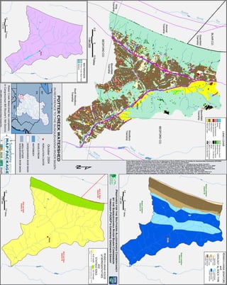
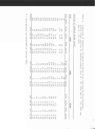
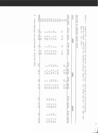
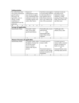
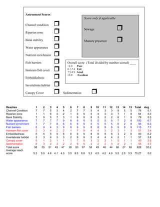
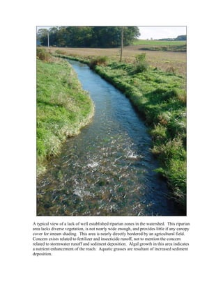
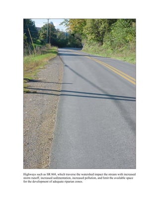
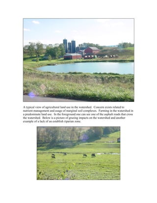
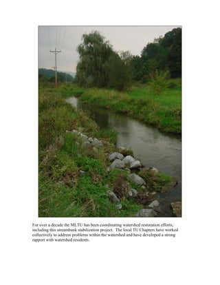
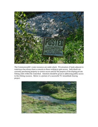
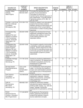
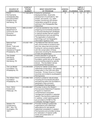
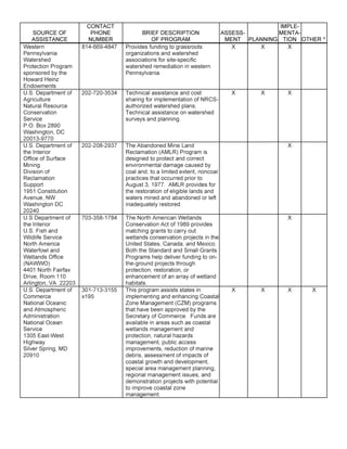
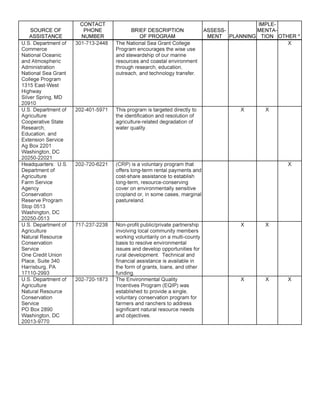
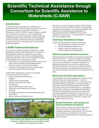
A Southern Alleghenies
Conservancy Project
COLDWATER HERITAGE
FINAL PRELIMINARY WATERSHED ASSESSMENT:
POTTER CREEK WATERSHED, YELLOW CREEK DRAINAGE
BEDFORD PA
PREPARED BY
SOUTHERN ALLEGHENIES CONSERVANCY
702 WEST PITT ST
FAIRLAWN COURT SUITE 8
BEDFORD, PA 15522
January 31, 2005
This report was completed for the
Mountain Laurel Chapter of Trout
Unlimited. Special thanks to the Blair
County and Fort Bedford Chapters of
Trout Unlimited and the Yellow Creek
Coalition.
1
Potter Creek Watershed- Study Area
2
Table of Contents
Executive Summary 5
I) Introduction 7
II) Watershed Characteristics 8
A) Location 8
B) Size of Watershed 9
C) Topography 9
D) Land Use 9
E) Land Resources 11
F) Geology 11
G) Water Resources 12
H) Biological Resources 15
III) Unique and Outstanding Values 16
IV) Field Assessment 16
V) Issues, Concerns, Threats 17
A) Erosion/Sedimentation 17
B) Sewage 19
C) Riparian Buffers 19
D) Habitat Fragmentation 20
E) Development 21
F) Farming/Farmland Preservation 22
G) Privatization/Loss of Public Access 23
VII) Recommendations 24
VIII) Public Comment 27
IX) Conclusions 28
Exhibit I Land Use Map
Exhibit II PA Fish and Boat Report
Exhibit IIII PA Natural Diversity Index Findings
Exhibit IV PA Game Commission Biologist Report
Exhibit V Field Assessment
Exhibit VI Conservation Easements
Exhibit VII Watershed Pictures
Exhibit VIII Watershed Assistance
Exhibit IX Watershed Residents
Exhibit X Funding Assistance
3
Acknowledgements:
Susquehanna River Basin Commission for GIS services and mapping
Guy Stottlemyer and Bedford County Conservation District for assistance with
macroinvertebrate and chemical sampling
Dan Mummert Southcentral Wildlife Diversity Biologist for his recommendation on
enhancing wildlife
Mountain Laurel Chapter of Trout Unlimited (MLTU) for support and volunteer
assistance
PA Fish and Boat Commission for providing Potter Creek sampling reports
Western PA Watershed Program, Department of Conservation and Natural Resources, PA
Fish and Boat Commission, and Trout Unlimited for their monetary support of the
Coldwater Heritage Program
The Western PA Conservancy’s Watershed Assistance Center for providing assistance in
developing a rapid bioassessment protocol for the project and GIS watershed delineation
4
Executive Summary:
The Yellow Creek Coalition, a facilitation group for watershed activities composed of the
Fort Bedford, Blair County, and Mountain Laurel Chapter of Trout Unlimited was
interested in obtaining baseline information on the Potter Creek Watershed. This group has
been coordinating restoration and conservation efforts within the watershed for over 12
years. The goals of this study was to identify: baseline information on the
macroinvertebrates and chemical parameters on the watershed, determine the land use
impacts within the watershed, investigate possible mitigation of land uses, determine the
overall health of the stream, and project what future impacts may occur in the watershed.
The keys to understanding the goals of this study involved the use of accepted scientific
practices as well as public input. In addition to meeting the aforementioned goals of the
study, the Southern Alleghenies Conservancy (SAC) was interested in asking the
following socioeconomic questions:
What are the concerns within the watershed?
The data collected as part of this study indicated that land use practices are increasing
sediment and nutrient loading into Potter Creek. The PA Department of Environmental
Protection’s (DEP) 303D List of Impaired Streams further substantiates this data. The
303D List is a mandated inventory of stream impairment under the direction of the
federal Environmental Protection Agency with guidance from the Clean Water Act.
According to the 303D List, Potter Creek is a category 5 impaired stream with the
primary impairments resulting from agricultural nutrient enrichment and sediment
loading.
A lack of riparian buffers within the watershed is negatively affecting the creek. These
buffers are necessary to filter out sediments and nutrients, regulate groundwater flow
during droughts, provide species habitat, regulate the water temperature, and provide food
for in-stream life. The absence of public sewage in the watershed is also a concern for
groundwater contamination and pathogen transport.
These negative environmental attributes affect the residents: Decreasing biodiversity,
increasing the potential for contamination of groundwater supplies, enhancing nutrient
enrichment/algal growth, and water pooling resulting in water stagnation. Additionally, a
reduction of in-stream fish food, reduction of fish populations, increased erosion, increased
flood potential, and increased risk of pathogenic vector habitat are also environmental
attributes of concern.
Concerns Documented for this Report:
• Erosion/Sedimentation
• Nutrient Loading
• Sewage
• Riparian Buffers (for biodiversity)
• Habitat Fragmentation
• Development, Privatization/Loss of Public Access
• Farming & Farmland Preservation
5
What can be done now to mitigate these impacts?
Simple, commonsense practices can be implemented to increase the health and vitality of
the watershed. By implementing habitat and water quality enhancement strategies such as
Agricultural Best Management Practices (BMPs), riparian plantings, and evaluation of
current land management within the watershed, the negative impacts can be mitigated. This
report outlines some specific concerns within the watershed and provides a list of options
for addressing the concerns.
What do we still need to understand or know to assist in solving the problem?
This report is a snapshot in time. Before this watershed assessment no previous data
existed for the tracking of positive or negative environmental impacts within the
watershed. This report should serve as a block in a foundation with future reports and
investigations building on the information provided. Information to be collected in the
future should include reevaluation of the visual assessment, macroinvertebrate studies,
fish studying, water chemistry evaluation, continued public involvement, and an
understanding of farmers using accepted BMPs and nutrient management strategies.
The Susquehanna River Basin Commission (SRBC) is conducting a macroinvertebrate and
chemical analysis of Potter Creek to better understand how this subdrainage is impairing
the Susquehanna River. This SRBC study is in year two and includes numerous other
points within the Yellow Creek Drainage. The point of contact for this study is Jen
Hoffman (717)-23 8-0423.
Southern Alleghenies Conservancy
702 West Pitt St
Fairlawn Court, Suite 8
Bedford, PA 15522
(814)-623-7900-5
sacproject@earthlink.net
6
I. Introduction
The Coldwater Heritage Partnership (CHP) program was introduced in February 1997 and
is a joint administered program among the PA Department of Conservation and Natural
Resources (DCNR), PA Fish and Boat Commission (PFBC), and the PA Council of Trout
Unlimited, with supporting contributions from the Western PA Watershed Program
(WPWP). The Program’s intent is to protect and enhance PA’s coldwater resources that
support or could potentially support reproducing wild trout populations. The primary
objectives of the Program are identifying and evaluating conditions within the designated
watershed, which have or are likely to have the most significant effects on coldwater
ecosystems.
The Potter Creek Study was sponsored by the Mountain Laurel Chapter of Trout Unlimited
(MLTU) in cooperation with the Yellow Creek Coalition (YCC), a facilitation group for
watershed activities composed of the Fort Bedford, Blair County, and Mountain Laurel
Chapter of Trout Unlimited (MLTU). Work pursuant to the report was completed by the
Southern Alleghenies Conservancy (SAC), a regional 501 (C) 3 nonprofit land trust
(www.saconservancy.org). The $5,000 grant award allowed the SAC to inventory and
document problems within the watershed. The process of inventorying and creating
recommendations was done with accepted scientific methods for watershed analysis and
employed the help of the Western PA Conservancy’s Watershed Technical Assistance
Center, the SAC, PFBC, volunteers from the MLTU, and YCC as well as from PA
Mountain Service Corps (AmeriCorps).
The purpose of this document is to provide baseline watershed data and serve as a
resource for further watershed restoration efforts. The project was undertaken at the
urging of MLTU and the Yellow Creek Coalition to provide baseline information for
future watershed comparisons. The group has been working strategically in the
watershed for the past decade and wishes to document the positive impacts that their
efforts are having in order to ensure that their watershed priorities are legitimate.
This report was created to assist in exploring the environmental assets and degradations
within the watershed. It outlines observations and provides recommendations. The SAC
should be contacted to discuss any data in the report that is perceived to be incorrect or
inaccurate. For the benefit of the reader, scientific terms are provided with definitions in a
glossary and additional pertinent report information is compiled in the appendix.
This plan should be viewed as a block in a foundation. It is by no means exhaustive, but
does explain the basic watershed characteristics and documents watershed/environmental
degradations. This report’s recommendations are intended to facilitate a discussion and
process for future action and landowner cooperation.
7
II. Watershed Characteristics
A. Location
Potter Creek is primarily located in Bloomfield Township northern Bedford County
with the upper portion of the watershed bordered by the Blair County line. State
Routes (SR) 867 and 868 form the primary highway access within the watershed.
Woodbury and South Woodbury Townships also comprise minor portions of the
watershed. The Potter Creek Watershed is bounded on the west by Dunning
Mountain and by upland regions east of SR 868. The area is commonly referred to
as Northern Morrisons Cove and is part of the Ridge and Valley ecologic region.
Watershed boundaries are formed on the west by uplands and Loysburg, to the east
by uplands and Woodbury, to the north primarily by Brumbaugh Mountain, and to
the south by SR 36.
The watershed’s central PA location provides a temperate climate with four
seasons. The area experiences varied temperatures and precipitation. The
watershed experiences an annual average temperature of 50.7o
F (The PA State
Climatologist). Likewise, the average precipitation for the area was calculated in a
similar manner and is approximately 39.99 inches annually (Ibid).
Township Information:*
Address: 422 Twin Ridge Road, New Enterprise, PA 16664
Township Building: Lafayette Road, Bakers Summit, PA 16614
Phone: 814-224-5367 or 814-224-5709 Fax: 814-224-2583
E-Mail: bloomtwp@cove.net
Meetings: 6PM on the first Monday of each month at the Twp Building
Chairman: George Ritchey
Roadmaster: Joe Detwiler
Solicitor: Ben Claar
Engineer: C & E Design Group
Sewage Enforcement: Barry Parks
Emergency Mgmt: George Ritchey
Ordinances: Building permit, nuisance, junkyard, subdivision
Sewage Plan: No
Tax Millage: 1.05 mills
* Bedford County Township Officials Association 2003 Directory of County, School, &
Municipal Officials (pg 5).
8
B. Size of Watershed
Potter Creek is part of the Susquehanna/Chesapeake Bay Basin; DEP management
subbasin 11, Upper Juniata Subbasin; DEP management Watershed D, Raystown
Branch of the Juniata River Watershed (Choose Your Watershed). Watershed D is
comprised of 416 square miles with a total population in 2000 of 18,310, with a
projected population of 18,736 by 2010 and continued growth through 2040 (Ibid).
According to geospatial interpretations provided by the Western PA Conservancy,
the entire Potter Creek watershed encompasses 13.35 square miles or 8544 acres
and drains southeasternly to Yellow Creek. Flow from the west originates from
Dunning Mountain and flows easterly toward the mainstem of Potter Creek, which
closely parallels SR 868. Few significant sources of water enter from the east. The
entire watershed is contained on the USGS New Enterprise 7.5 minute topographic
map.
C. Topography
The entire watershed exhibits a dendritic drainage pattern. The straight-line distance
of the stream is approximately 6.4 miles, but due to the sinuous nature of the stream
its actual length is approximately 7.3 miles. The sinuosity of the stream is 0.88,
indicating that the stream exhibits characteristics of a meandering stream, but not
extreme meandering properties. The change in elevation from the headwaters to the
mouth of Potter Creek is 260 feet. This change in elevation represents an average
stream gradient of 35 feet per mile, represented as a slope of 0.6%, which is
indicative of a mature topography and a mature, relatively flat stream with minimal
down cutting, generally slow moving, and lower oxygenated water. Tributaries
entering from Dunning Mountain to the west exhibit much higher gradients and are
capable of transporting higher amounts of sediment and higher water velocities.
Tributaries along this western front have gradients of 300 feet per 0.5 miles or a
slope of more than 11%.
D. Land Use
Farming is a major land use in Bedford County. According to the 1982 Natural
Resources Inventory, 141,100 acres were used for crops and 57,000 acres were
used for pasture. The 1984 PA Crop and Livestock Annual Summary reported
35,600 acres of corn, 8,900 acres of small grain, and 55,600 acres of alfalfa and
other hay. The rest was in pasture, idle cropland, or other uses (Soil Survey of
Bedford County 85).
9
The following information was obtained from the Bedford County Soil Survey,
completed by the USDA in 1998 (Ibid 87).
Forested lands in Bedford County cover about 436,700 acres. They
accounted for up to 67% of the total land use in the county. Of the 421,700
acres of commercial forest land, about 83% is privately owned and 17% is
publicly owned. Approximately 3% of forest land is noncommercial.
Softwoods, oaks, and northern hardwoods comprise the forest regime of
the county. These forest resources are managed by private property
owners, the PA Game Commission, and the DCNR.
Land use in the watershed is diverse, but primarily associated with agricultural
(visual estimate from GIS data 85%), residential, and forest use (See exhibit1).
Churches, cemeteries, residential dwellings, industrial identified operations, as well
as one public utility land use exist in the watershed. In addition to these land uses,
the PA Game Commission manages a large tract of land in the northeastern portion
of the watershed for public access- State Game Lands 41.
The watershed is teaming with wildlife supported by the varied matrix of croplands,
pasture lands, and woodlands. Wildlife inhabitants include: whitetailed deer,
squirrels, cottontail rabbits, bears, grouse, turkey, ringneck pheasants, as well as
other traditional game species. The watershed also has a wide range of amphibians,
reptiles, and songbirds.
There is no large population center located within the watershed. According to the
aquatic survey conducted by the PFBC in 1991, the population density of the
watershed was 14 residents per km2
. The nearest population centers are New
Enterprise, Loysburg, and Woodbury, all of which are outside the watershed.
A Rural Utility substation exists near the confluence of Potter Creek with Yellow
Creek. This substation is located near the intersection of SR 36 and 868. The SAC
conducted a phone interview with a rural utility spokesperson to determine if
Polychlorinated Biphenyls (PCBs) were present as coolants in the onsite electrical
transformers. The spokesperson assured us that no PCBs were present onsite, nor
were any spilled in the future. The spokesperson also assured staff that creosote
utility poles were being properly managed.
A recreational, dirt-track facility is located at 40o
12.757’ N and 078o
26.620’ W at
an elevation of 1,400’. This facility seemed to be having little impact on the
watershed, but should be monitored as it is near one sustained tributary and
several ephemeral tributaries.
10
E. Land Resources
Soils and rock lithologies within the Potter Creek Watershed consist of largely
Ordavician and Cambrian age sediments, which were created by the Taconian
Orogeny (PA GEO inside cover). The majority of the soil complexes found in the
watershed are not considered “prime agricultural soils”, with the exception of
Hagerstown Complexes. Soil complexes adjacent to Potter Creek and its tributaries
are highly erodable and consist of Opequon-Hagerstown Complex.
There are building and land use limitations for watershed soils. Shallow bedrock
inhibits excavation, swelling of clays causes heaving/cracking concerns, and
inability to pass perk tests restrict development within the watershed. Agricultural
uses for soils throughout the watershed vary. Soils such as the Morrison Channery
Sandy Loam are of statewide farmland importance, but are highly erodable. Care
needs to be taken with all soils in the watershed, as they are all highly erodable.
Watershed Soils
Group Symbol(s) Limitations Land use Concerns
Hagerstown Silt
Loam*
HeB Steepness, acidity,
rock fragments,
erosion, moderate
runoff
Pasture, cultivated
crops, woodlands
Ability to perk test,
erosion potential,
foundation and
basement
construction
Morrison-Murril
Complex*
MtC Rockiness,
steepness, severe
runoff, high
permeability
Pasture,
woodlands,
cultivated crops (if
rocks removed)
Ability to perk test,
severe erosion pot-
ential,
Opequon-
Hagerstown
Complex*
OpB, OpC, OpD,
OpE
Varying erosion
potential, flooding,
high watertable
Suitable for most
uses, but uses vary
based on the
characteristics of
the Complex
Flooding, high
watertable, perk
testing, erosion and
runoff potential
*Source USDA Soil Survey of Bedford County, PA 1998
F. Geology
The Potter Creek Watershed was impacted by the Taconian Orogeny of the
Ordavician and Cambrian periods (PA Geology 86). Once the Taconian Orogeny
began and the continental plates collided, folding and subduction occurred. The
subsequent collision and folding of the continental plates continued to deepen the
oceanic environment between the continents forming marine sediments such as
limestone. Evidence of this is seen in the differing composition of marine rock
lithologies and based on other geological data. Subsequent erosion of the mountain
chain formed during this period added terrestrial, nonlimestone derived sediments to
the area (i.e. sandstones and shales).
11
The watershed is largely underlain by karst (limestone) geology. This geological
formation was a result of the oceanic conditions prior to and during the orogeny.
Karst geology has a host of environmental concerns. Some of these concerns
include sinkholes, closed depressions, disappearing streams, rapid inflow of
surface water to the watertable, and rapid nutrient and contaminant transport
through the aquifer to name a few. Surface feature evidence of the limestone
geology is limited to rock outcropping and numerous diffuse springs. Topographic
map interpretation, rock outcropping, and GIS information all substantiate the
presence of karst geology. Chemical analysis of the stream showed high alkalinity
readings, further substantiating a groundwater source originating from or
interacting with limestone lithologies. The alkalinity generated by limestone
dissolution provides a prime pH and alkalinity for the biomass of the stream,
buffering it from impacts of acid rain and other acidic introduction.
This karst geology contributes greatly to the cold water that is necessary to sustain
suitable water conditions for the Class A Trout populations of Potter Creek.
Additionally, the multiple springs and seeps throughout the watershed add flow and
suitable water chemistry throughout the middle to lower reaches of Potter Creek-
aiding in dilution of agricultural and other contaminates.
G. Water Resources
Potter Creek is managed as an unstocked wild trout fishery and has both PFBC
Class A and DEP High Quality Cold Water Fishery (HQ CWF) designations.
Potter Creek drains approximately 13.35 square miles southeasterly to Yellow
Creek, also regarded as a prime recreational resource for fishing. There is only
one United States Geological Survey (USGS) named tributary within the
watershed- Snyder Creek.
Numerous farm ponds and water impoundments exist in the watershed. These
ponds were likely constructed for aesthetic value and for fire suppression.
Basic water chemistry indicated the Creek is indeed spring fed and has high levels
of calcium carbonate (alkalinity). Lower nitrate rates in the middle and lower
reaches are likely resultant from higher flows and an influx of spring water, diluting
the contaminates. The highest nitrate levels were observed in the upperportions of
the mainsteam at Site 2, as predicted prior to sampling. This location has poor
upstream Ag BMPs and animals were seen in the stream. Lush riparian cover is
lacking in this area as well.
12
Parameter Site 1 Site 2 Site 3 Site 4 Site 5
Water temperature (C) 10.5 10.5 11 10.5 10.5
pH 7.5 7 7.25 7.25 7.25
Dissolved Oxygen 10.6 8.9 10.1 10.6 10.3
Alkalinity (ppm) 223 220 220 226 210
Nitrates (mg/L) 6.5 7.8 5.85 3.6 3.85
Turbidity (JTU) 2.5 0 0.5 0 0
Orthophosphate 0 0 0 0 0
Chemical data provided by: Guy Stottlemyer of the Bedford County Conservation District
collected 10-2004.
Subsequent chemical information will be available at a later date from the
Susquehanna River Basin Commission (SRBC). SRBC is conducting quarterly
chemical sampling as part of the Yellow Creek sub-basin survey.
A basic macroinvertebrate study was completed as part of this assessment to
gauge the health of this aquatic resource. The survey was conducted by Bedford
County Conservation District’s Guy Stottlemyer, Watershed Specialist.
Macroinvertebrate Survey Summary
Site 1 Site 2 Site 3 Site 4 Site 5
# of taxa (family level) 10 9 7 11 13
EPT taxa 2 3 3 4 6
% dominance 84 75 75 54 34
Sensitive taxa index 4.08 3.75 7.07 2.82 3.91
Biosurvey score 9 9 3 15 15
The time of year and preceding storm events may have slightly skewed survey data. Future
sampling at different times throughout the year should be conducted to get a better understanding
of the macro community.
Stottlemyer’s conclusions:
The biosurvey score developed from the metrics indicates a fair community
structure at four of the five sites and a poor rating for site 3. Sites 1 and 2 are near
the low end of the fair range, while 4 and 5 are upper end scores. Sites 4 and 5
exhibit more moderate dominance percentages, and these were instances of
Ephemeroptera species being the dominant organism, while the dominance ratings
at sites 1, 2, and 3 resulted from large numbers of amphipods (1 and 2) or
oligochaetes (3).
Two considerations must be mentioned in interpreting these scores. First, the season
the collection was undertaken likely resulted in depressed numbers of the very types
(Ephemeroptera and Trichoptera) that could have contributed to higher indices.
Second, the nature of the stream (low gradient, meadow, carbonate geology) limits
the opportunities for members of the shredder communities that contribute to higher
indices as well as limiting habitat for a greater diversity of types. It is generally
recognized that the metrics developed for a more generic model of rocky bottom
streams do not always serve well in assessing ‘spring creeks’ such as Potter. The
Ephemeroptera community was strongly represented by Beatidae species,
13
which are not usually sensitive to the impairments considered to be of concern on
Potter Creek (i.e. sediment and nutrients). The dominance of Baetidae was
influenced by the season of collection as noted above; baetids were ‘hatching’
during the collection period.
Water quality parameters indicated nitrate levels of concern at all sites.
Orthophosphate was not detectable but this result has been obtained in most
sampling when not occurring during an event that contributes to higher turbidity
or when not immediately downstream from a potent source, such as a septic
outfall.
The low to moderate diversity of Trichoptera and Ephemeroptera species noted
correlates with the lack of habitat diversity available for benthic organisms. The
stream bottom is largely gravel; cobble, particularly larger units, is uncommon
while boulders and large woody debris are rare. Representatives of the shredder
functional feeding group are absent, possibly influenced by the lack of leaf packs in
the stream and the scarcity of riparian woody plants.
In summary, the macroinvertebrate community is consistent with a stream
impaired by agricultural nutrient and sediment runoff. The presence of
Rhyacophila and Ephemerella species is an encouraging sign that perhaps
conditions are improving. The lack of macroinvertebrate habitat diversity is
likely a current limiting taxon diversity.
Stottlemyer’s conclusions further substantiate the findings listed under the Field
Assessment section. This assessment documented that a lack of in-stream habitat,
lack of riparian buffers (forested), as well as sediment loading, is negatively
impacting the ecosystem.
Subsequent macroinvertebrate information will be available at a later date from
the Susquehanna River Basin Commission (SRBC). SRBC is conducting macro
sampling as part of the Yellow Creek Subbasin Survey.
14
Fin Fish reports were provided for inclusion in this study by the PA Fish and Boat Commission
(See exhibit 2). The following is a summary of the 2000 report:
Common Name Scientific Name Present in Survey Years
Rainbow trout* Oncorhynchus mykiss 1991
Brown trout* Salmo trutta 1979,1991,1999
Brook trout* Salvelinus fontinalis 1979,1991,1999
Palomino* Oncorhynchus mykiss 1991
Blacknose Dace* Rhinichythys atratulus 1979
Creek Chub* Semotilus atromaculatus 1979
White sucker* Catostomous commersoni 1979, 1999
Northern Hog Sucker* Hypentelium nigricans 1979
Sculpins* Cottus sp. 1979, 1999
* As reported in July 17, 2000 F&BC report
H. Biological Resources
After consulting the PA Natural Heritage Index for Bedford County, there were no
known threatened or endangered species within the watershed. Several species
identified through the PA Natural Diversity Inventory (PNDI) exist in close
proximity to the watershed. Additional information on possible species of concern
was obtained from investigating the Wild Resources Conservation Fund’s
Endangered and Threatened Species of PA, 1995.
Common Name Scientific Name Listed Type
Eastern Woodrat* Neotoma magister Threatened Animal
Upland Sandpiper* Bartramia longicanda Threatened Bird
Canby’s Mountain
Lover*
Paxistima canbyi Gray Endangered Plant
Shale-Barren Evening
Primrose*
Oenothera argillicola
Mackenzie
Threatened Plant
* Information provided by Wild Resources Conservation Fund’s Endangered and
Threatened Species of PA, 1995
Threatened- species may become endangered within the foreseeable future throughout
their range in PA.
Endangered- species is in immanent danger of extinction or extirpation throughout their
range in PA.
An additional PNDI investigation from the Western PA Conservancy has
indicated that species of concern may exist within the watershed. To further
evaluate this risk for disturbing these threatened and endangered species, a
thorough evaluation of the watershed by a biologist and botanist would be
necessary (See exhibit 3).
15
A watershed biological survey was conducted by Dan Mummert, PA Game Commision’s
Southcentral Wildlife Diversity Biologist. Dan listed the following potential species of
concern present for the watershed: Hellbender, Fowlers toad, mountain chorus frong,
northern leopard frog, eastern box turtle, wood turtle, eastern hognose snake, great blue
heron, great egret, black-crowned night heron, yellow-crowned night heron, northern
harrier, American woodcock, and bank swallow. As per Dan’s survey, he recommended
that forested riparian buffers be established throughout the watershed to assist in protecting
the species of concern. In addition, Dan suggested the development of streambank fencing,
creation of habitat piles, and installation of bird boxes (See exhibit 4).
III. Unique and Outstanding Values
Potter Creek is a picturesque watershed nestled between Dunning Mountain and State
Game Lands 41. The watershed’s population density is low and the landscape is
predominately agricultural with interspersed forested land. Areas exist for fishing, hunting,
hiking, biking, and general outdoor recreation. Potter Creek is locally renowned for its
excellent fishing, although it is a stream for the more experienced angler.
Population centers such as Bedford, Altoona, Hollidaysburg, and Martinsburg are easily
accessible via major highways such as I-99 and SR 36, making the watershed an attractive
area for commuters.
Near-by attractions include: State Game Lands 41, Yellow Creek, the Raystown Branch of
the Juniata River, Morrisons Cove Memorial Park, Altoona, Lakemont Park, Blair County
Ballpark, Blue Knob State Park, Old Bedford Village, Shawnee and Canoe Creek State
Parks, and Historic Downtown Bedford.
IV. Field Assessment
(For specific field assessment data see Exhibit 5)
A visual field assessment was conducted to baseline the existing conditions within the
watershed. A standard visual assessment was provided by the Western PA
Conservancy’s Watershed Assistance Center. The assessment goal was to obtain a
snapshot in time of environmental impacts within the watershed and to baseline the
accomplishments of the Yellow Creek Coalition’s past restoration and preservation
efforts.
As part of the study, volunteers were assigned predetermined reaches for evaluation.
Reaches were defined primarily by land use and were designated by SAC staff.
16
A reference reach was not delineated for the study; instead, another accepted practice was
used. At the aforementioned instructional meeting, attendees created an ‘ideal reach’. These
parameters were set as a comparison to reaches the members were to survey. The
characteristics of the ‘ideal reach’ served as a ‘perfect ten’ for study purposes. Reaches
surveyed were mentally compared to this list of ‘perfect ten’ parameters and then scored
accordingly.
Assessment results indicated that the stream was impaired by sedimentation, as verified
by the DEP’s 303D Impaired Streams List. Additional results verified the general
observation that the watershed lacks forested riparian buffers, canopy cover, invertebrate
habitat, and in-stream fish cover.
The visual assessment indicated that reaches 7 and 8 were positively impacted by the
work of MLTU and YCC. These reaches exhibited high scores, as attributed to the
streambank fencing completed years ago. The visual assessment provided baseline
information for comparing future successes by MLTU and YCC.
IV. ISSUES, CONCERNS, AND THREATS
EROSION and SEDIMENTATION
According to the USDA’s Soil Survey of Bedford County, soil erosion is the major soil
management problem on most of the cropland and pasture in Bedford County. Although
Hagerstown, Murril, and Westmoreland soils are among the best for agricultural usage,
they are also highly erodable.
As indicated in the Visual Assessment and in the DEP 303D List, erosion and
sedimentation are contributing to the degradation of Potter Creek. Evidence of this was
seen in the relative imbeddedness of several macroinvertebrate sampling points. Recent
flood events and high precipitation events have flushed the channel of some sediment. The
Yellow Creek Coalition and the Mountain Laurel Chapter of Trout Unlimited (MLTU)
have focused efforts at curtailing farming practices that allow cows to cross the stream and
browse in the stream. This partnership has worked over the past 14 years with property
owners to complete beneficial projects in the watershed that address these specific issues.
Practices such as streambank fencing are helping the mainstem, but a larger area of
concern exists in areas predominantly found in the upper portions of the mainstem and
along the western tributaries that drain from Dunning Mountain under SR 867. Farming in
these areas of higher topographic relief are utilizing marginal (Op Complex) soil types for
agriculture- thus increasing the potential for erosion. Water velocities in these areas are
also higher as a result of adjacent Dunning Mountain. Fine sediments created by animal
waste, soil erosion, fertilization of land, and storm water run-off are easily capable of
being transported down these tributaries and into the mainstem.
17
The practice of using steep slopes and inadequate soil types is likely exacerbating erosion
problems within the entire watershed and contributing to sediment loading of Potter Creek.
Throughout the watershed agricultural practices are utilizing Opequon-Hagerstown Soil
Complexes. Concern exists that many of these areas should not be utilized for agriculture.
As previously mentioned, the gradient of tributaries is also a factor of concern throughout
the watershed’s western tributaries. It was also noted that these tributaries are often void of
covercrops, soil is often exposed, and filter strips often were not in place to buffer sediment
transport into the tributaries and ultimately into Potter Creek.
Sedimentation is a multifaceted concern for the aquatic and human populations of Potter
Creek. Increased sedimentation of Potter Creek decreases habitat for aquatic
macroinvertebrates and feeder fish. Additionally, sedimentation increases growth of in-
stream aquatic plants, increases water temperature (discolored water or turbidity acts much
like a black shirt on a sunny day), detracts from the aesthetic beauty of the stream, and
impacts benthic plants and organisms. Sediment accumulation impedes flows and can
cause areas of stagnation, resulting in breeding grounds for pathogenic vectors such as
muskrats, mosquitoes, and bacteria.
Sediment-laden streams also have a reduced water conveyance and carrying capacity.
Sediment-choked channels impede high water flows, increasing the risk of flooding and
property damage, which exacerbates erosion of unprotected streamside soils. The resultant
flooding reduces property values, increases environmental degradation and risk for
pathogenic transfer of disease and illness. Due to the general flatness of the property
adjacent to the mainstem, erosional activities and earth disturbances in the headwaters will
significantly impact properties adjacent to the mainstem.
Recommendation:
Best Management Practices (BMPs) for agricultural and residential use need to be
implemented to protect soils within the watershed. Simple practices such as conservation
tillage, buffer strips, and cover cropping will help to ensure soil stability. Residents should
consider not mowing their yards to the stream’s edge and should promote the development
of riparian zones that will trap sediment and assist in enhancing the ecosystem’s diversity.
Consideration should also be given to re-evaluating agricultural practices in marginal,
highly erodable soils, and possibly removing them from production. Several programs exist
to pay farmers for abandoning marginal lands; one such program is the Conservation
Reserve Enhancement Program (CREP). The YCC should continue its efforts in the
watershed to promote streambank fencing. Areas where the YCC has completed streambank
fencing projects demonstrated less sedimentation and more stable banks, as per the visual
assessment.
18
SEWAGE
Fecal coliform testing was not conducted to prove the existence of sewage leaks. As there is
no public sewage system in the watershed, a concern exists that septic tanks could be
contaminating water quality. Improper maintenance or lack of septic system maintenance
could result in contaminated private water wells, groundwater supplies, and surface water
resources. Infiltration of human excrement into consumptive water supplies increases the
potential for gastrointestinal irritation and human illness.
Recommendation:
An inventory of onlot sewage systems should be created to include date of installation,
maintenance, and other parameters of interest. The township should lead a program to
document the existence of onlot sewage systems and gather construction information. The
township sewage enforcement officer would be the logical contact to develop a plan for
ensuring that all sewage systems are functioning properly and that they are not
contributing to contamination of private drinking wells or elevated nitrates in Potter
Creek. John Dawes of the WPWP would be able to provide contact information related to
innovations in onlot sewage systems being explored at Delaware Valley Ag School by Larry
Hepner. An additional resource for onlot sewage would be the National Small Flows
Clearinghouse (1-800-624-8301).
RIPARIAN BUFFERS
A visual inspection of the watershed estimated that approximately 75% of the mainstem
was void of adequate canopy cover. The number one concern, as determined in the visual
assessment of the entire mainstem, related to this lack of canopy covering and forested
riparian buffer. In addition to a lack of canopy cover, it was observed that none of the
mainstem was protected by an adequate forested riparian buffer, as per the visual
assessment protocol. The lack of forested riparian buffers are of great concern. These
buffers serve a myriad of purposes. As indicated in Dan Mummert’s report, these buffers
serve as vital habitat for amphibians, reptiles, birds, and mammals and increase the
reproductive ability of fish and other organisms. They provide vegetative cover to the
stream, temperature control of the water, detritus or plant debris for aquatic organism
consumption and in-stream habitat, they reduce surface water velocity, provide surface
water storage that assists in flood prevention, and filter sediments and contaminates from
surface water. Additionally, these buffers help to maintain sustained flows during droughts
(Wildlife Habitat In PA Past, Present and Future 83).
Riparian Buffers are critical for biodiversity and habitat. As a general rule the larger the
buffer, the more animals and organisms present. Riparian buffers are most beneficial when
they extend 50-100 feet perpendicular to the stream in all directions (Ibid 84). A buffer of
this extent would be nearly impossible to achieve in the Potter Creek Watershed because of
the streams’ close proximity to roadways.
19
Species Portion of Riparian Buffer Utilized (in feet)
Reptiles and Amphibians* 100-200
Otters* 200-330
Mink* 200-330
Large Mammals (fox, bobcats,
etc)*
400
Bald eagles, hawks* 300+
Songbirds* 300+
* Information obtained from (Wildlife Habitat In PA Past, Present and Future 84).
Recommendation:
Enhancing riparian buffers and streambank fencing is of utmost concern- it is evident in the
visual assessment that this is a lacking Ag BMP. In order to facilitate the development of
streambank buffers and streambank fencing TU should look to utilize programs listed in the
appendix to support their efforts. Additionally, the newly hired PA Game Commission
Regional Biologist will be able to assist in providing guidance for the sound installation of
said buffers. Dan Mummert, the Regional Biologist for the watershed can be reached at
814-542-8759 or via email at dmummert@state.pa.us. Implementation should focus on
landowners along the tributaries emanating from Dunning Mountain. Additionally, TU
should give consideration to addressing the specific findings as outlined in the interpretation
of the visual assessment data. The YCC should continue to schedule, coordinate, and
implement streambank stabilization and streambank fencing as well as buffer rehabilitation
in the watershed. The YCC should institute stream bank fencing designs that do not impede
public access to the stream. Lastly, the YCC should work with all landowners to develop
filter strips, along the tributaries and mainstem.
HABITAT FRAGMENTATION
Numerous state and township highways fragment the Potter Creek watershed. These
highway corridors, although narrow, provide an impediment to the natural movement of
wildlife throughout the watershed. This fragmentation of habitat reduces the range of
wildlife, increases predation, and causes increased wildlife interaction with humans.
Fragmentation can lead to inbreeding resulting from isolation, resulting in a reduction of
species fitness (Wildlife Habitat In PA Past, Present and Future 108). In extreme cases, a
change in air pressure of a passing car on a highway can cause the collapse or expulsion of
the internal organs of amphibians (Ibid). Damage to the lower trophic levels of the food
chain causes a ripple-effect in predators and upper levels of the food chain. The residential
development is also a habitat fragmentation concern.
Recommendation:
Watershed residents concerned with fragmentation should work with their township
officials to develop zoning requirements and subdivision ordinances. Zoning is not a
popular concept, but has many benefits.
20
DEVELOPMENT
The Potter Creek region, like the rest of PA, has experienced a trend over the past several
decades of population shifts from urban to suburban and rural areas. According to statistics,
this decentralized migration has accounted for 1.12 million acres of land development
between 1992-1997 (Planning for Agriculture 1). Most of this land development impacted
farmlands (Ibid). There has been a marked increase in development within the watershed.
Residential development is expanding in the watershed. This increased development is
fragmenting the grassland and forest habitats within the watershed; creating stress on
agriculture and ground water resources, not to mention increasing the potential
environmental pollution from sewage and household chemicals. Additionally, as
development encroaches on wildlife habitat, wildlife mortality increases. As a simple
example, it is estimated that household windows kill on average 4 million birds annually,
not to mention deer vs. vehicular accidents (Wildlife Habitat In PA Past, Present and Future
124). Cats and dogs can cause reductions in small mammal populations in close proximity
to dwellings (Ibid 125). Lighting, fertilizers, and residential land management also impact
wildlife in the area of dwellings.
The watershed will likely continue to experience increased development pressure. Trends
within the Commonwealth indicate that urban sprawl is an increasing pressure on rural and
suburban landscapes. As Altoona and proximal population centers expand, the population
density of the watershed is likely to increase.
Increased development also will impact the watershed with increased storm and surface
water runoff attributed to roofs, paved driveways, decreased vegetative interception,
decreased forested habitat, and increases in roadways for conveyance of traffic.
Additionally, household contamination of surface and ground water are of concern as is
the possible depletion of groundwater drinking sources.
Currently, soil types are helping to curtail development within the watershed, as not all of
the soils in the watershed are capable of passing sewage percolation tests. Conventional
methods for municipal sewage treatment are not cost-effective for the low population
density of this area. However, as development pressure increases the population density
may support the cost of a public sewer system.
21
Two simple examples of how development can significantly impact surface water runoff
and flood potential are provided below. The calculations were developed by SAC staff and
used standard hydrological constants such as 7.43 gallon per cubic foot.
A house with a gabled roof with each side measuring 20*40 feet will contribute 987
gallons of runoff during a one-inch rain event.
20*40= 800 square feet * 2 sides=1600 ft2
1 inch of rain expressed as a portion of a foot=
.0833 feet 1600 ft2
* .0833 feet= 133.28ft3
*
7.43gallons/ft3
= 987 gallons
Similarly, a driveway measuring 15*100 of impermeable surface will contribute 928
gallons of runoff during a one-inch rain event.
15 * 100= 1500 ft2
1 inch of rain expressed as a portion of a foot=
.0833 feet 1500 ft2
* .0833 feet= 124.95ft3
*
7.43gallons/ft3
= 928 gallons
Recommendation:
Although sprawl and subsequent development is largely uncontrollable, sound zoning,
subdivision ordinances, and public involvement can reduce the impacts of development.
Watershed residents should engage their township officials in a review of development
ordinances and subdivision planning. Additionally, consideration should be given to
developing ordinances that address storm water runoff. As the numbers indicate above,
storm water runoff can be a huge problem and a flood hazard, as impermeable surfaces
increase and vegetation decreases. An unfamiliar practice, yet a useful one, is the
development of dry wells. This technique bores holes for the purpose of storing storm
water and slowly releasing it into the watertable. Such a practice drills into a permeable
layer of soil, but stops before water is encountered- thus a dry well is formed.
Consideration should be given to making this a new subdivision ordinance.
FARMING & FARMLAND PRESERVATION
A lack of agricultural BMPs, forested riparian buffers, feedlot ground cover, proper
feedlot drainage, and streambank fencing are impacting the watershed. Furthermore, use
of marginal soils, cultivating to the water’s edge, and grazing forested habitats are also
impacting the watershed. Farmers are having an increasingly difficult time making a
living. The Commonwealth’s farm population density peaked around 1900 when two
thirds of the state was farmland (Wildlife Habitat In PA Past, Present and Future 134).
Recent trends in PA cause concern regarding habitat loss in rural PA- during the 1990’s
rural populations grew by 10% as city populations decreased by 4% (2002 Annual Report
Land Use 37).
With residential dwellings being constructed closer on the fringes of agricultural uses, the
PA General Assembly enacted the Right to Farm Act in 1982 (Planning for Agriculture 22).
This law affords farmers some limited protection from nuisance ordinances and nuisance
lawsuits (Ibid). Farming is a mainstay in PA and several precautions have been taken to
protect farming interests. The purpose of the legislation was to reduce the loss of
agricultural operations in PA by limiting the circumstances under which these
22
operations could be the subject of nuisance suits. To that end, the Right to Farm Act does
three things. First, it limits municipalities from including ‘normal agricultural operations’
within their nuisance ordinances (Ibid). Second, it limits municipalities from restricting
sales of agricultural commodities on the farm in their zoning ordinances (Ibid). Third, it
limits nuisance suits against agricultural operations (Ibid).
When farming practices are done properly and best management practices (BMPs) are
followed, agriculture can enhance wildlife. Farming can provide a wide array of habitats
and the large tracks of land necessary for farming helps to prevent development pressures.
Recommendation:
Time should be spent verifying agricultural compliance with nutrient management
regulations. The local USDA Service Center can assist with this process. Funding is
available for agricultural assistance through the Natural Resource Conservation Service’s
Environmental Quality Incentives Program (EQIP). It is imperative that farmers in the
watershed are using BMPs and that their nutrient management plans are up to date. There
are numerous programs intended to assist farmers that have nutrient management plans.
For more information on available programs, see appendix or contact Lou Pierce (listed in
the reference section of the appendix). Additional assistance for evaluating farming
practices is available through the American Clean Water Foundation’s On-Farm
Assessment and Environmental Review Program (www.acwf.org/projects/ofaer.html).
Agricultural BMPs should include: use of cover crops, conservation tillage, application
buffers for nutrients, and timely application of nutrients.
PRIVITAZATION/LOSS of PUBLIC ACCESS
A private party is actively pursuing the purchase of land rights adjacent to Potter Creek.
The individual is offering to purchase, lease, or otherwise compensate landowners for the use
of their property. This agreement stipulates that stream access is limited to a membership
clientele. Property agreements have already been negotiated with landowners in the Yellow
Creek watershed.
Recommendation:
Increasing pressure is being placed on land and water resources that provide the public
with areas to fish and recreate throughout the area. To thwart such pressure in the Potter
Creek watershed, conservation easements should be formalized with property owners.
Development, private property rights, as well as venture capitalists have the opportunity to
impact the recreational availability of Potter Creek. Concerned parties should work with
the PA Fish and Boat Commission, Township Supervisors, the SAC, and the Bedford
County Conservation District to ensure that the resource remains open for recreation.
General state shield laws, such as the Recreational Use of Land and Water Act of 1968,
provide general liability protection to landowners that have their land open to the public.
Conservation easements and land access agreements would be beneficial tools in this
process. The SAC is currently working its solicitor and the YCC to draft a formal process
for assisting landowners in protecting their property access. For more information on
Conservation Easements see exhibit 6.
23
Next steps
1. Parties interested in the health and vitality of the watershed should form a
watershed group.
• Residents within the watershed should consider joining the efforts of MLTU
and form a watershed association to protect Potter Creek’s unique resources.
This group should focus on obtaining funding for facilitating mailings and
seminars of Best Management Practices (BMPs) for homeowners as well as
farms. Additional focus from the group should be directed toward farmers and
residents that have property adjacent to Potter Creek or one of its tributaries,
encouraging conservation programming exploration. Guy Stottlemyer, Bedford
County Conservation District Watershed Specialist will be able to assist
(814)623-7900-123.
2. Consideration should be given to restoring the sinuosity, especially in the lower
reaches, of the stream; natural stream channel design techniques should be
employed. Guy Stottlemyer will be able to assist.
3. Funding should be sought to continue macroinvertebrate and chemical monitoring
and to compile data collected by the SRBC study.
• Residents and/or watershed members should considering working with the
USGS Consortium for Scientific Assistance to Watersheds (CSAW) Program to
develop a comprehensive monitoring program. This program should include
monitoring of riparian buffers, land usage, BMPs, chemical parameters, as
well as biological indicators. Those interested in the CSAW Program should
contact Dave Steele of the Southern Alleghenies RC&D at 814-623-7900 Ext
119. Once the application has been filed with the RC&D and approved, experts
from the USGS will assist local stakeholders in developing a watershed
monitoring program that will meet their needs. For more information see the
appendix. Additionally, the Bedford County Conservation District’s
Watershed Specialist Guy Stottlemyer can assist in these endeavors.
4. Educating the residents of the watershed on the value and potential of their
watershed is highly important. Minor changes in the management of residential
properties could provide substantial improvement to the water quality of Potter
Creek.
• Educational outreach is vital to the success of implementing the
recommendations in this plan. State agencies and others are most receptive to
grassroots-led initiatives for change. Educational activities such as the
development of brochures indicating the benefits of riparian buffers could have
a marked benefit to Potter Creek. The Three Rivers Habitat Partnership and the
WPWP would be able to assist with this process.
• Current nuisance ordinances should be enforced. Removal of junk and
burning barrels from the floodplain- and in some cases from the stream-
should be a priority.
24
• Township ordinances exist to address junkyards and nuisances. These
ordinances should be enforced and include the elimination of nuisances from
the floodway. Burning barrels and junked cars in the floodway or stream
corridor are not only aesthetically displeasing, but are also hazards to wildlife
and aquatic organisms. Leaking oil or other fluids from the cars can negatively
impact the stream. Burning household wastes and then dumping the ashes into
the stream could cause fine sediment deposition and introduction of hazardous
chemicals into the stream. One site in the upper reaches of the watershed had
several junked cars near the stream and a burning barrel. Near the intersection
of SR 36 and 868 a small barnyard and burning barrel were located practically
in the stream. These issues may require intervention on the part of the PA
DEP.
5. The PA Emergency Management Agency, township Emergency Manager, and the
Bedford County Emergency Management Director should be contacted to develop
a spill-response plan for Potter Creek. Since the highways in the watershed
closely parallel the creek, a plan should be developed for emergency response.
• Emergency management personnel from the township, county, and state should
work together to develop a rapid response plan to address any contaminate
spilled within this high quality watershed. The creek’s close proximity to the
highway makes potential contamination from a motor vehicle accident,
petroleum, or agricultural-related spill probable in the future. Instituing rapid
response and proper containment strategies is critical for the continued health
and vitality of Potter Creek. This objective should start with the township
Emergency Management Official George Ritchey, who can be reached at 814-
224-5938, or by contacting Bedford County EMS official David Cubbison at
814-623-9117 ext 2.
• Time should be spent ensuring that diesel and other fuel tanks are located away
from Potter Creek and its tributaries. Additionally, all outside tanks serving
industrial purposes should have containment vessels to prevent spills from
entering into the waterways. Two tanks were noted 50-75 feet from the edge of
Snyder Creek at 629 Snyder Road.
6. The PA Department of Transportation should be contacted to explore innovative
approaches to resolving the issues discussed such as reduced buffers, implementing
permeable pavement strategies, no spray right-of-way management strategies,
advanced snow removal procedures, and the use of zero velocity spreaders, etc.
• The PA Department of Transportation has a responsibility to manage and
maintain its highway system with the natural resources in mind. Contact should
be made with the District 9 Office in Hollidaysburg 814-696-7125. DOT should
be encouraged to use no-spray maintenance practices for maintaining their
right-of-ways, increase setbacks of the highway from Potter Creek, assist in
increasing safety measures on their highways to prevent hazardous spills, use of
nonhazardous asphalt maintenance, and the use of zero velocity Tyler spreaders
to reduce direct impacts of salt and winter maintenance activities on Potter
Creek.
25
7. The WPWP should be contacted about Delaware Valley’s innovations in onlot
sewage that may be beneficial in addressing sewage concerns and the potential for
development in the area.
• John Dawes of the WPWP would be able to provide contact information
related to innovations in onlot sewage systems being explored at Delaware
Valley Ag School. An additional resource for onlot sewage would be the
National Small Flows Clearinghouse 1-800-624-8301.
8. An inventory of onlot sewage systems should be created to include date of
installation, maintenance, and other parameters of interest.
• The township should lead a program to document the existence of onlot
sewage systems and gather construction information. The township sewage
enforcement officer would be the logical person to contact to develop a plan
for ensuring that all sewage systems are functioning properly and that they are
not contributing to contamination of private drinking wells or Potter Creek.
9. The PF&BC should continue conducting fish surveys within the watershed and
continue to manage this Class A Trout resource as an unstocked wild trout fishery.
Additionally, PF&BC should work with local stakeholders, DCNR, and township
supervisors to address concerns related to public access of this water resource.
• See implementation recommendation #6.
10. An inventory of macroinvertebrates should be conducted as should a baseline of
analytical chemical components.
• See implementation recommendation #4. Additional assistance for a
volunteer-based monitoring strategy is possible. Guy Stottlemyer of the
Bedford County Conservation District would be able to assist in the
development of any macro-sampling plan and can assist with said activities.
26
VII. Public Input
A public meeting was held January 18, 2005 at the Cove Lions Club, Loysburg, PA from
7PM to 8:30PM. The meeting was advertised in local newspapers and by a direct mailing to
watershed residents. The meeting was attended by 18 people and consisted of a formal
presentation of findings followed by a period of questions and answers.
The following list of concerns were generated regarding the plan and the watershed in
general.
• Several trees have fallen in the upper portions of the watershed which are
diverting flow from the channel through a farmer’s field. The cause of this
problem was attributed to the recent storm events.
The SAC was unable to locate this concern in a follow-up visit to the
watershed.
• A pond on Snyder Creek Road was an issue of concern for one resident. The
concern is that the pond has become nutrient enriched and during times of
high runoff may be contributing to nutrient problems in the channel.
The only potential pond that the SAC identified on Snyder Creek Road was
located at 40o
12.948’ N and 078o
26.224’ W at an elevation of 1368. Water
samples were not taken from the pond. The pond was fenced off from cows,
but agricultural runoff may be entering the pond. Cows were standing in the
stream at this location. This area along with a farm located at the intersection
of Furry and Snyder Road should also be the site of future stream fencing
projects.
• Residents are concerned that additional streambank fencing may cause
impediments to water access and constrict the channel.
• Riparian zones are adequately developed within the watershed for managing
nutrient runoff, but as outlined in the plan are not adequate for biodiversity.
• A watershed approach should be taken instead of focusing on specific
watershed problems.
• Highway drains are a concern to residents, as they are outletting directly into
the waterway.
• The extension of the sewer line crossing through Loysburg to Woodbury is a
concern, as is the potential subdivision of large land parcels in the upper-
portions of the watershed.
• Concern was expressed in how the Mennonite population would view the plan
entation strategy.and how to incorporate them into its implem
• Funding for plan initiatives was discussed.
• Acid deposition was discussed as a component of the plan that should get
attention in the future.
• Residents were in strong support of a spill response plan.
• It was noted that the addition of shrubs and native grasses would enhance the
riparian zone and slightly improve terrestrial biodiversity.
27
VIII. Conclusions
This study and report is not to be viewed as an exhaustive study, nor an exhaustive search
of data and resources relating to the Potter Creek Watershed. The intent of this report was
to gather baseline data and to make general hypothesizes about the general health and
projected trends within the watershed. The study outlines key components involved in the
scientific evaluation of the watershed and is supplemented with a list of recommendations
and action items. These items are meant to assist TU and others in the protection of this
coldwater resource.
The overall health and vitality of Potter Creek is being impacted by the land uses that
involve the highly erodable soil types that exist within the boundaries of the watershed.
Soil complexes associated with the Clarksburg, Hagerstown, Holly, Morrision, Murril,
and Opequon are all highly erodable, yet well suited for the agricultural practices that
dominate the watershed. In addition to being highly erodable, these soils also exhibit
geological structures and properties that assist in the transport of contaminates and are
poorly suited for building and development. The complexes are also poorly suited for
highway construction, basement building, general excavation, in some instances poorly
tillable, and exhibit characteristics not suitable to pond/lagoon construction and are
moderately limited for the development of onlot septic systems.
Farming practices in the watershed are a concern. Farmlands that are tilled to the stream’s
edge or the edge of tributaries to Potter Creek are of extreme concern, based on the
general eroabability of the soils in the area. Large portions of the watershed exhibit little
riparian zone buffering. The highly erosive nature of the soils and their relatively low
permeability make nutrient runoff into Potter Creek and its tributaries a concern as well.
Practices of grazing in Potter Creek seem to have been addressed to a great degree by the
MLTU and its partners through the Yellow Creek Coalition. Care should be exercised
when farming operations apply fertilizer to their fields; nutrient management plans need to
be strictly followed, and any earthen storage installations should be constructed of
approved material. Consideration should be given to planting crops that would have the
ability to buffer erosion and nutrient impacts to the stream. Cover crops should always be
planted and soils should not be left barren or unprotected.
Residential properties adjacent to the waterways in the watershed appear to be impacting
the stream. Lawns throughout the watershed run to the edge of the waterways and are
likely impacting the waterways and contributing to nutrient loading. A lack of riparian
buffers along residential properties is evident throughout the watershed. This lack of
vegetative cover increases water temperature, reduces habitat, reduces feed sources,
increases predation, increases transport of nutrients and sediment, and increases runoff.
There is also concern with burning barrels, at least one junk yard, and several instances
where individuals have driven through the stream.
Highway construction throughout the watershed is also impacting the stream. As
previously mentioned, underlying limestone formations in the watershed and abundant
amounts of clay cause associated difficulties for building and construction. The highway
systems throughout the watershed have obviously been constructed with sound
28
engineering practices and contain substantial sub-bases and adequate drainage to reduce
the formation of potholes associated with clay expansion and contraction. However, the
highways that traverse the watershed contribute a large portion of runoff to the adjacent
highly erodable soils; in many cases highway drain outlet directly into the waterway.
The general proximity of highways to the waterways throughout the watershed is of
extreme concern. Due to limited space for the construction of said highways, little attention
has been given to creating riparian buffers. Highway maintenance likely impacts the
watercourses throughout the watershed. Winter highway maintenance likely contributes
excess sediment in the form of salt and anti-skid to the stream. Salt entering the stream
likely increases the stream’s conductivity and oxidizes any iron bearing minerals that may
be found in the stream. Snow melt and relatively constant flows likely reduce this concern.
Penn DOT should be engaged in a discussion to use zero velocity spreaders for winter
maintenance and no-spray methods for maintaining right-of-ways.
Residential development seems to be increasing within the watershed. The potential
expansion of this development is likely to be limited by the soils in the area. On-lot sewage
is moderately impeded by the watershed’s soils- namely their poor drainage and tendency
to pond. After the recent heavy rains associated with the 2004 Hurricane Season, some of
the soils within the watershed exhibited ponding for well over 30-45 days. Future
residential growth is likely to materialize as mobile homes and prefabricated homes that
have lower costs; such cost savings could be used to offset excavation and other costs. A
municipal sewage system now exists to the south of the watershed, paralleling SR 36. This
sewage system, funded by the United States Department of Agriculture Rural Development
(USDA RD), will be owned and operated by South Woodbury Township and should have
little development impact on the Potter Creek Watershed. If subdivision of large land
parcels takes place and causes a rapid increase in housing interest in the watershed, the
economics of scale could make an extension of this sewage system feasible. Darrell
Clapper of the USDA RD has indicated that currently, too few residents exist in the
watershed to justify the $70 per foot cost of this sewage extension. Darrell has indicated
that the USDA RD has been contacted about the prospects of developing a sewage
management plan for Baker’s Summit that may have implications for Potter Creek
residents.
Although the watershed is being impacted by the aforementioned environmental concerns,
the relative health of the watershed is favorable. The inflow of multiple springs and seeps
in the middle and lower reaches of the mainstem is likely diluting the pollution of marginal
agricultural practices throughout the watershed. Following the recommendations of this
report would likely increase aquatic health and diversity as well as provide a larger
carrying capacity for existing aquatic populations. The results of all of the scientific data
collected via the visual assessment, the biological survey, chemical, and macroinvertebrate
survey all support the concerns expressed in this plan.
29
Funding should be sought to continue the monitoring efforts started under this plan.
Additional funding should be sought to educate the watershed residents and elected
officials on low-impact development and smart-use techniques. The residents that
attended the public meeting were eager to assist TU and others in exploring potential
projects that would benefit the watershed. This creative, cooperative energy should be
harnessed and a watershed organization should be formed.
Continued partnerships and outreach will create positive change in the watershed and
enhance the aquatic resources as well as enhance the current property values. Anyone
reading this report having questions should contact the SAC for clarification or
assistance.
30
References Cited
Choose Your Watershed. Available at:
http://www.dep. state.pa.us/dep/deputate/watermgt/Wc/Subj ects/WSNoteBks/ws 11 d.htm.
Accessed: 9/22/2004.
Barber, Patricia; Bishop, Joseph A; Brittingham, Dr. Margaret; Goodrich, Laurie J.
Wildlife Habitat in Pennsylvania: Past, Present, and Future. Unknown Publisher and
unknown date of publication.
Knight, William R. Soil Survey of Bedford County, Pennsylvania. US Department of
Agriculture, 1998.
Governor’s Center for Local Government Services. Commonwealth of PA, January 2003.
2002 Annual Report on Land Use. Available at:
http://www.landuseinpa.com/docs/Annual_Report_2002/. Accessed: 3/15/2005.
The Agricultural Law Research and Education Center of The Dickenson School of Law of
the PA State University. Planning for Agriculture. PA Department of Community and
Economic Development, 2003.
The State Climatologist. Available at:
http://pasc.met.psu.edu/PA_Climatologist/State/divsum08.htm. Accessed 9/22/2004.
Shultz, Charles H (editor). The Geology of Pennsylvania. PA: Commonwealth of Pa,
1999.
31
Glossary of Terms
ordered by appearance in the document.
PA Department of Conservation of Natural Resources (DCNR)- Commonwealth
department tasked with the protection of natural resources both land and water, also
responsible for upkeep and operations of State Parks and State Forests
PA Fish and Boat Commission (PFBC)- Commonwealth department tasked with the
protection of fish and aquatic resources and regulation of fish, aquatic, and boating
regulations
PA Council of Trout Unlimited (PA TU)- PA organization of the nationally based
conservation group Trout Unlimited that focus on angling, protection of fishable waters,
and public outreach
Western PA Watershed Program (WPWP)- a small grants program based in Alexandria,
PA that provides funding assistance to watershed groups and other nonprofits for the
restoration and protection of water resources
Yellow Creek Coalition (YCC)- the facilitation and coordinating organization for the
Blair, Fort Bedford, and Mountain Laurel Chapters of Trout Unlimited
Southern Alleghenies Conservancy (SAC)- a regional nonprofit organization based in
Bedford, PA serving the cultural, historical, and environmental resources of a six county
region (Somerset, Bedford, Fulton, Huntingdon, Blair, and Cambria)
Western PA Conservancy’s Watershed Technical Assistance Center- technical service
branch of the nonprofit environmental organization the Western PA Conservancy,
providing advice and assistance to groups interested in watershed issues
Mainstem- the portion of the stream that represents the main stream’s course and
channel, tributaries drain into the mainstem
Watershed- a geographic feature that defines a particular drainage area of surface water.
Watersheds can be limited in size or can include large expanses of area
Dendritic- a geologic and hydrologic term given to streams exhibiting a branching
pattern of tributaries. This stream pattern is typically found in the northeast
Straight-line distance- a measurement of distance in a straight line from the origin of the
mainstem of a stream to the mouth of the stream (point of intersecting with another body of
water); this measurement can be expressed in any desirable unit of distance
32
Sinuosity- reference to the amount of bending back and forth (meandering) that a stream
does. Sinuosity can be expressed as a ratio (straight-line distance/ actual distance traveled
by the stream); the smaller the resultant calculation of this ratio the high the sinuosity of
the body of water (i.e. a ratio of 1:1 would indicate a straight line)
Stream gradient- a calculation represented as the change in elevation over a given
distance that indicates the steepness of a stream; this calculation is important for
interpreting erosional forces and other hydrologically significant factors that influence
stream composition and impacts
Lithologies- geologic term for a rock unit
Ordavician- representation of geologic time associated with the time period of 490-443
Million Years Ago (MYA)
Cambrian- representation of geologic time associated with the time period of 543-490
MYA
Taconian Orogeny- mountain building event that took place circa 450 MYA
Subduction- geologic term given to the act of continental plates sliding underneath one
another, usually associated with mountain building events and volcano formation
Terrestrial- land based environment
Orogeny- geologic term for mountain building events
Sinkholes- a surface feature associated with the chemical weathering and physical
collapse of underlying geology resulting in an open depression on the earth’s surface
Closed-depressions- a surface feature associated with the chemical weathering and
physical collapse of underlying geology that results in a ‘dent’ with no apparent hole in
the center of the dent
Disappearing streams- a surface feature of karst geologic settings by which a flowing
body of water disappears from the earth’s surface and then travels in the subsurface to
interact with groundwater or to be transported and resurface at a different location;
streams may disappear as a result of rock fractures, fissures, faults, or into sinkholes
Class A Trout- a stream classification under the 1983 standards of Operation FUTURE
that has a representative Brown Trout population of at least 30kg/hectare or
approximately 88lbs/2.47 acres
33
PA Department of Environmental Protection (PA DEP)- department of PA
Commonwealth responsible for safeguarding our natural environment (air, water, soil,
mineral resources, etc) that has regulatory authority and ability to excise fines for
environmental wrong doing; the DEP is responsible for carrying out water quality
compliance and standards developed by the federal Environmental Protection Agency
(EPA)
High Quality Cold Water Fishery (HQ CWF)- designation of the PA DEP for
waterways under Chapter 93 that denotes such a watercourse as providing for the
maintenance and or propagation of fish and flora and fauna indigenous to cold water
habitats which have excellent quality waters and environmental or other features that
require special water quality protection
Macroinvertebrate- small organisms without backbones (i.e. aquatic bugs in this study)
PA Natural Heritage Index for Bedford County- document with information related to
habitat areas and species of plants and animals that are of significance and deserving of
special protection
PA Natural Diversity Inventory (PNDI)- a state database that has coordinates/locations
of known plant and animal species of concern needing special protection under the
Endangered Species Act
Water Clarity- the transparentness of water, factors influencing clarity including
sediment, suspended solids, nutrient loading, and other biological agents that discolor
water
Habitat Regimes- represent different areas for the inhabitance of plant and animal life
(i.e. woodland, pasture, crop, residential, prairie, grassland, aquatic)
Canopy Cover- amount of available shading and protection (cover) provided by all types
of vegetation; canopy cover is import in moderating the temperature of the stream
Aeration- act of adding oxygen to the waterway, most commonly associated with water
flowing over rocks
Riffle and Pool Sequence- sequences of fast moving well oxygenated environments
followed by areas of still water
Biodiversity- the variability or diversity of species within a given habitat
Substrate- aquatic subsurface
Down Cutting- active erosional processes stream deepening, resulting in incised
channels with drastic changes in streambed elevations of a short distance
34
Lateral Cutting- active erosional process of stream bank erosion
Rip-rap- stone aggregate usually of volleyball size or larger that is used to reduce
erosion of streambanks and to stabilize the streambank
Riparian Area (aka Riparian buffer)- the area adjacent to a stream that supports the
growth of various plants and serves as a habitat interface between aquatic and terrestrial
organisms; critical for habitat and cleansing of streams and trapping of transported
sediments
Sheen- luster associated with chemical pollution, usually multicolored and forming a
‘film’ on top of the water column
Macrophytes- plants that are growing in the stream
Scour- abrasion to the stream bed, usually caused by rapid moving water and influenced by
changes in stream flow, which causes transport of sediment and impacts stream clarity
Percent Embeddedness- the amount of sediment that is around (cementing) rocks into
the substrate in an area of rapid water movement as expressed in a percentage
USDA- United State Department of Agriculture, federal department tasked with the
support of agriculture and agricultural initiatives as well as rural and public utility
projects
Streambank fencing- the act of installing fence adjacent to streams to prevent foraging,
browsing, and cattle traversing in the stream’s course
Sediment loading- geologic and hydrologic term given to the deposition and associated
accumulation of sediment in a waterway
Feeder fish- small fish such as minnows that are consumed by larger fish
Pathogenic- capably of causing diseases or illness in animals or humans (i.e giardi, ecoli,
West Nile Virus)
Vector- a means of transmission or carrier (i.e. rats, mosquitoes)
Habitat Fragmentation- dividing habitat regimes and creating isolation of habitat
through development and destruction of habitat (i.e. deforestation, residential
construction in the forest, highway construction)
35
EXHIBIT 1
LAND USE MAP
!(
RobertJubelirer
District30
RobertJubelirer
District30
RobertJubelirer
District30
Maria
!(
BLAIRCO.
BEDFORDCO.
BEDFORDCO.
Boiling
Spring Run
Yellow
Creek
Bottom
Cr.
Hickory
Woodbury
Township
Bloomfield
Township
Bloomfield
Township
Greenfield
Township
Kimmel
Township
King
Township
SouthWoodbury
Township
Maria
!(
JerryA.Stern
District80
DickLeeHess
District78
DickLeeHess
District78
Maria
¹
Product Made Possible by Partnerships with PA Org. for Watersheds & Rivers (POWR), Eastern PA Coalition for Abandoned Mine Reclamation (EPCAMR),
Western PA Coalition for Abandoned Mine Reclamation (WPCAMR), PA Spatial Data Access (PASDA)
POPULATION CENTER: Environmental Systems Research Institute (ESRI); RIVER/STREAM: U.S. Geological Survey; ROAD: PennDOT;
WATERBODY: U.S.G.S., Susquehanna River Basin Commission, and Chesapeake Bay Program; SUSQUEHANNA RIVER BASIN: U.S.G.S.; AREA
OUTSIDE SUSQUEHANNA RIVER BASIN: ESRI; CONGRESSIONAL DISTRICT: PennDOT, 2002; MINOR CIVIL DIVISIONS: PennDOT; COUNTY
BOUNDARY: PADEP; WETLAND: U.S. Fish and Wildlife Service's National Wetlands Inventory; ABANDONED MINE LAND and PROBLEM AREA:
PADEP; LAND USE: Chesapeake Bay Program (Peter Clagget, GIS Program); GEOLOGY, ROCK TYPE: SRBC; PENNSYLVANIA
SENATORS and HOUSE of REPRESENTATIVES: Penn State Harrisburg, 2002 and Pa Legislators Home Page, 2003; STATSGO SOILS: U.S.
Department of Agriculture's State Soil Geographic (STATSGO). SRBC(1017a) 10-07-2004 Map-Jeff Zimmerman, Jr.; Layout-Donna Gavin
PreparedfortheSouthernAllegheniesConservancy
bytheSusquehannaRiverBasinCommission
throughPADEP'sGrowingGreenerGrant
0.500.5Miles
0.500.5Miles
0.500.5Miles
1:97,000
1:97,000
1:64,000
PENNSYLVANIASENATORS
and
GEOLOGYbyROCKTYPE
Sandstone
LAYERED:Folded
Shale
LAYERED:Folded
Quartzite
LAYERED:Folded
Dolomite
LAYERED:Carbonate
LAYERED:Carbonate
Limestone
PENNSYLVANIAHOUSE
ofREPRESENTATIVES
and
STATSGOSOILS
AUD-Udalfs
Moistsoilwithhighclay
content
IOC-Ochrepts
Moderatelydeveloped,pale-colored
soil,lacksorganicmaterial
NY
PA
MD
PotterCreekWatershedliescompletely
inCongressmanBillShuster's9thDistrict.
DISCLAIMER:IntendedforEducationalDisplayPurposesOnly
POTTERCREEKWATERSHED
INREFERENCETOTHESUSQUEHANNARIVERBASIN
October2004
POPULATIONCENTER!(
RIVER/STREAM
SUSQUEHANNARIVERBASIN
AREAOUTSIDE
SUSQUEHANNARIVERBASIN
WATERBODY
!
!
!(
Maria
0.500.5Miles
1:130,000
LANDCOVER
NaturalGrass
Road
Barren/Extractive
ConiferousForest
MixedForest
DeciduousForest
Water
LowDevelopment
HighDevelopment
Hay/Pasture
RowCropsMinorCivilDivision
CountyBoundary
Wetland
WATERSHEDS
Wetland
PotterCreekWatershed
EXHIBIT 2
PA FISH & BOAT REPORT
EXHIBIT 3
PA NATURAL DIVERSITY INDEX FINDINGS
Western Pennsylvania Conservancy Pennsylvania Dept. of Conservation and Natural Resources The Nature Conservancy
209 Fourth Ave Bureau of Forestry 208 Airport Drive
Pittsburgh, Pa 15222 PO Box 8552 Middletown, PA 17057
(412) 288-2777 Harrisburg, PA 17105-8552 (717)948-3962
www.paconserve.org
March 12, 2004
Branden Diehl
Southern Alleghenies Conservancy
sacproject@earthlink.net
Re: List of Species and Natural Communities of Special Concern in the Potter Creek Watershed, Bedford
County
Dear Mr. Diehl,
A search of the Pennsylvania Natural Heritage Program database yielded the following results for the Potter
Creek watershed:
Scientific Name Common Name EORANK GRANK SRANK
Last
Observed
PA
Status PBSSTATUS
Fed
Status
Arabis hirsuta
Western Hairy
Rock-cress H G5 S1 1946-06-02 TU PE
The ridge between Potter Creek and Yellow Creek is made up of dolomite/limestone rock (Gatesburg, Bellfonte,
Axemann, and Warrior formations). The wetlands along Yellow Creek, which support the rare plants and the
natural community listed below, are fed by water seeping through this limestone. Similar wetlands could exist
on the Potter Creek side of the ridge. Therefore, these species and community could exist undiscovered if there
are wetlands in the Potter Creek watershed.
Scientific Name Common Name EORANK GRANK SRANK
Last
Observed
PA
Status PBSSTATUS
Occurrence
Number
Fed
Status
Salix x subsericea Meadow Willow H G5 S1 1963-04-23 TU PE 2.000000
Pedicularis lanceolata Swamp Lousewort H G5 S1S2 1951-09-01 N PE 3.000000
Rhamnus lanceolata
Lance-leaved
Buckthorn H G5 S1 1954-07-08 PE PE 1.000000
Galium trifidum Marsh Bedstraw H G5 S2 1961-08-07 N PR 3.000000
Lathyrus palustris Vetchling H G5 S1 1962-05-29 TU PE 3.000000
Lathyrus palustris Vetchling H G5 S1 1962-05-29 TU PE 5.000000
Carex prairea Prairie Sedge E G5? S2 1995-06-01 PT PT 2.000000
Carex tetanica A Sedge E G4G5 S2 1995-06-02 PT PT 9.000000
Rhynchospora
capillacea Capillary Beaked-rush H G5 S1 1961-07-26 PE PE 1.000000
Cladium mariscoides Twig Rush E G5 S2 1995-06-02 PE PE 2.000000
Juncus arcticus var.
littoralis Baltic Rush E G5T5 S2 1986-06-22 PT PT 16.000000
Carex schweinitzii Schweinitz's Sedge C G3 S1 1986-06-22 PT PE 8.000000
Juncus arcticus var. Baltic Rush H G5T5 S2 1961-07-16 PT PT 7.000000
(717)787-3444 www.tnc.org
www.dcnr.state.pa.us
littoralis
Carex sterilis Sterile Sedge H G4 S1 1962-06-13 PT PE 9.000000
Potamogeton hillii Hill's Pondweed E G3 S1 1993-08-19 PE PE 2.000000
Rhynchospora
capillacea Capillary Beaked-rush H G5 S1 1961-07-26 PE PE 2.000000
Panicum flexile Wiry Witchgrass H G5 S2S3 1961-09-16 TU TU 2.000000
Eriophorum gracile Slender Cotton-grass H G5 S1 1875-06-15 PE PE 5.000000
Carex sterilis Sterile Sedge E G4 S1 1993-07-02 PT PE 1.000000
Eleocharis elliptica Slender Spike-rush B G5 S2 1987-06-29 PE PE 4.000000
Carex sterilis Sterile Sedge B G4 S1 1995-06-02 PT PE 3.000000
Galium labradoricum
Labrador Marsh
Bedstraw B G5 S1 1987-06-29 PE PE 1.000000
Juncus arcticus var.
littoralis Baltic Rush B G5T5 S2 1995-06-02 PT PT 4.000000
Basin graminoid-forb
fen
Basin Graminoid-forb
Fen E GNR S1 1995-06--- 9.000000
Please note that the many species and the natural community of special concern should be the targets of field
studies within the Potter Creek watershed. If funding can be arranged for to support such inventory work, our
staff botanists and ecologists would be very interested in conducting such a study in order to inform and improve
watershed conservation information and planning.
PNHPCLAUSE
Pennsylvania Natural Heritage Program (PNHP) maintains a site-specific information system that describes significant
natural resources of Pennsylvania. This system includes data descriptive of plant and animal species of special
concern, exemplary natural communities and unique geological features. PNHP is partnership of the Department of
Conservation and Natural Resources, The Nature Conservancy, and the Western Pennsylvania Conservancy.
The information provided is confidential due to the potential sensitivity of the species to disturbance, landowner
privacy, and authorship. The data have been provided to you at no charge as a conservation partner to better protect
species of special concern in Pennsylvania. The data are not to be distributed without prior written permission from the
PNHP program. This information is provide for use in this single project and may not be applied to future projects
without updates from the PNHP database.
This response represents the most up-to-date summary of the PNHP data files but does not constitute a response to a
request for environmental review as related to an application for a development permit. Keep in mind that an absence
of recorded information does not necessarily imply actual conditions on-site. A field survey of any site may reveal
previously unreported populations.
Please let me know if this response satisfies your needs. Thank you for your request.
Sincerely,
Kierstin Carlson
Conservation Data Manager
Pennsylvania Natural Heritage Program - Western Pennsylvania Conservancy
Enc. Status and term definitions
cc: Pinnizotto
Wright
EXHIBIT 4
PA GAME COMMISSION BIOLOGIST REPORT
..........
. . . . . . . . . .
PennsylvaniaGameCommission
WildlifeHabitat
ManagementPlan
Preparedby: Dan Mummert
Southcentral Wildlife Diversity Biologist
(814) 542-8759
Preparedfor: SouthernAllegheniesConservancy
(PotterCreekWatershed)
..........
2
WildlifeManagement
Plan
Objectives and Land use
Landowner Objectives
To best manage the Potter Creek Watershed for overall riparian health.
Land use History
Trout Unlimited has done some stream bank fencing and tree plantings within
the riparian buffer zone of the watershed.
Much of the adjacent land is associated with agriculture.
Property Description
General Habitat Description
Total Acres: The watershed is contained within 13 square miles
Location: The Potter Creek Watershed of Bedford County
Types Present
Wetland X
Forest
Riparian Forest X
Grassland
Early Sucessional
Other
Unique Natural Areas/Features/Habitats
This watershed includes pristine spring-fed creeks
Species
Species observed on property
Potential species of concern present
Hellbender, Fowlers toad, mountain chorus frog, northern leopard frog,
eastern box turtle, wood turtle, eastern hognose snake, great blue heron, great
egret, black-crowned night heron, yellow-crowned night heron, northern
harrier, American woodcock, bank swallow
Species of concern targeted for management
Hellbender, Fowlers toad, mountain chorus frog, northern leopard frog,
eastern box turtle, wood turtle, eastern hognose snake, great blue heron, great
egret, black-crowned night heron, yellow-crowned night heron, northern
harrier, American woodcock, bank swallow
3
..........
4
Management
Management Recommendations
1. Much of the Potter Creek watershed lacks a sufficient riparian buffer.
Riparian buffers provide many benefits for wildlife and greatly improve
water quality for humans. Riparian buffers protect water quality by
intercepting sediment and pollution from adjacent agricultural fields,
residential lawns, and roads. Riparian buffers also improve habitat for
many wildlife species including fish, frogs, turtles, salamanders, aquatic
macroinvertebrates, and birds associated with wetlands and riparian
corridors such as kingfisher, heron and egret. As a general rule, wider
buffers with greater diversity of plantings will provide the most positive
benefits for wildlife and the overall health of the watershed. A total width
of 25-50 feet from the stream’s edge is usually the minimum suggested as
an effective buffer for bank stabilization and water quality control. Water
quality will increase with wider buffers and most species of wildlife
require a wider buffer. It is therefore suggested that sections of the
watershed riparian corridor be between 100-300 feet to help mitigate the
impact of the adjacent agricultural land use and to provide quality habitat
for an increased diversity of wildlife. When creating a riparian corridor it
is helpful to conceptualize multiple zones.
a. Zone 1- Begins at the water’s edge and has the main purpose of
providing bank stabilization as well as shade and organic inputs
(dead woody debris and leaves) for the stream health. In this zone
larger trees and shrubs should be planted that have a high tolerance
for wet conditions. It should be noted that only native trees and
shrubs should be planted in any land management program.
Examples of native trees and shrubs to plant in the Zone 1 region
would include: American holly, Eastern hemlock, green ash, white
ash, river birch, willow oak, American cranberrybush, mountain
laurel, silky dogwood, spicebush, and winterberry. The benefits to
wildlife with these plantings along Zone 1 are numerous. The
plantings will shade the water which will help maintain a cooler
water temperature for fish. Fallen branches and leaves will provide
food and shelter for fish, aquatic insects and amphibians. Fallen
branches and trees will also slow the water velocity to help
decrease streambank erosion. Belted kingfisher use overhanging
branches as perch sites to locate fish. The entire watershed should
at the minimum have a continuous Zone 1 buffer that is at least 25
feet wide on each side of the creek.
b. Zone 2- Much of the watershed should also include this buffer
zone that extends from 25 feet to about 50 feet from each side of
the creek. This zone is forest-shrubland that helps to absorb excess
nutrients, preventing them from entering the water. This zone also
helps slow runoff and allows runoff to slowly recharge the
groundwater supply. This zone provides an important travel
corridor for wildlife. Shrubs and trees provide food and cover for
wildlife. Amphibians use low-lying pools that are seasonally wet
for breeding. Examples of trees and shrubs to plant in this region
include: American holly, inkberry, persimmon, gray dogwood, red
oak, black chokeberry, flowering dogwood, winterberry, white
oak, eastern hemlock, black cherry, and mapleleaf viburnum.
c. Zone 3- Any areas of the riparian corridor that extend beyond
about 50 feet could be considered within this zone. In this area it is
suggested that grassland habitat be planted and maintained. In
agricultural areas this grassy zone has a highly beneficial impact
on slowing runoff and trapping sediment. If wide enough, this area
can also provide important grassland habitat for species such as
eastern meadowlark and barn owl. Within this zone bluebird boxes
can also be placed to attract bluebirds and tree swallows (making
sure to monitor against house sparrow usage). Within this zone
native warm-season grasses such as switchgrass, indiangrass, big
bluestem, and little bluestem can be planted. Cool season grasses
such as orchardgrass and timothy would also be beneficial in this
zone.
2. It is suggested that a stream bank fencing program be initiated for the
Potter Creek watershed. Stream bank fencing is a simple, cost-effective
way to improve water quality in streams flowing through agricultural land
containing livestock. By installing fences and cattle crossings, livestock
has limited access to the stream bank which allows for the establishment
of a vegetative riparian buffer. Positive effects of stream bank fencing also
include reduced soil erosion, increased nutrient absorption, improved
wildlife habitat, increased cattle health (due to reduced contact with
waterborne bacteria that cause black leg, mastitis, and other ailments), and
enhanced aesthetics of the landscape.
3. After riparian buffers have been established, bluebird and possibly wood
duck nest boxes should be installed in appropriate locations. Bluebird
boxes should be placed 5 feet above the ground on metal or wooden poles
with predator guards. Boxes should be separated by at least 125 feet to
avoid intraspecific competition. They should also be placed at least 300
feet from any man-made structure to avoid usage by house sparrows.
Bluebird boxes should only be installed if routinely monitored during the
breeding season. If boxes are not monitored for either bluebird or tree
5
.......... swallow usage, house sparrows (an invasive, exotic species) may begin
using the boxes.
Wood duck nest boxes should be installed within the riparian buffer in
areas of mature forest where there is an abundance of vegetation within
and on the border of the creek. Wood duck nest boxes should be separated
by at least 200 feet to avoid nest dumping behavior.
4. Large downed woody debris piles would provide valuable cover habitat
for a number of species such as salamanders, snakes, rabbits, fox, mice,
shrews, etc. I would suggest creating several piles within the riparian
buffer zone in locations without an extensive understory. Woody debris
piles should be created by placing large limbs and tree trunks on the
bottom with perpendicularly facing smaller limbs on top. There should be
holes and cavities created of varying sizes for varying sizes of animals
using the different cavities. On the very top of the pile small-diameter
brush should be placed to help seal out the weather and provide additional
cover habitat for songbirds.
5. To provide habitat for bats, I would recommend maintaining dead snags,
shagbark hickory and other trees with loose bark throughout the Potter
Creek watershed. These provide ideal roosting habitat for several bat
species. If bats are properly managed for they can greatly decrease the
number of mosquitoes and other flying insects throughout the watershed.
6
EXHIBIT 5
FIELD ASSESSMENT
EXHIBIT 5
Procedure for developing ‘ideal reach’:
At the meeting, held on September 27, 2003 at the New Frontier Restaurant, members
were asked to describe parameters of a watershed that they envisioned as pristine and
undisturbed. Their task was to provide parameters for scoring evaluations of the sample
reaches on Potter Creek. The scoring associated with the sample reaches correlate to how
closely the Potter Creek reaches matched the ‘ideal reach’. Reaches scoring a 10
correlated to a perfect match of the ‘ideal reach’, whereas scores of 2 or 3 would indicate
an extreme deviation from the ‘ideal reach’.
Characteristics of the Ideal (Reference Reach) included:
Water clarity
Stable banks
Numerous habitat regimes
Constant/sustained flow
Spring fed
Canopy Cover
Temperatures conducive to aquatic organisms
Aeration
Riffle and pool sequences
Free from manmade structures and interference (fences, houses, retaining walls)
Limited access
Narrow width
Abundant biodiversity (plant and animal communities)
Calcium carbonate influenced water source
Spawning beds
Stable substrate
Meandering
Stable riparian zone (meadow, forest, grassland or other biota)
An ‘ideal reach’ encompassed all of the above criteria. After the meeting attendees
and SAC staff went out to a sample reach to discuss the scoring parameters of the
reach, using the criteria developed for the ‘ideal reach’ and the visual assessment. A
consensus was reached on scoring and an understanding of the procedure was
accomplished.
Assessment Guidance- Special Notes
Conduct the survey in groups. The groups should ideally contain 3 individuals. The
purpose in utilizing a group approach is to develop a consensus as to the scoring of the
reach.
Cruise, verify, and document your assigned sample reaches. Cruise; quickly perform a
visual assessment of the entire sample reach. Verify; look at any areas that are of
particular concern or out of the ordinary. Document; record the score for the sample
reach on your scoring sheet. BE SURE to score the entire reach as a whole. If someone
were to reassess your reach, your assessed value should be representative of their score.
Gauge each scoring parameter individually giving it a score ranging from 1-10, with 10
being a perfect correlation to the reference reach. It is imperative to score each parameter
based on what it is asking. Scoring ‘Bank Stability’ has nothing to do with the water’s
general appearance; as such turbidity should not influence your score of ‘Bank Stability’.
Be sure to discuss each parameter being scored and challenge each others opinions and
observations. Once a collective agreement has been made, document the appropriate
score on your scoring sheets.
Take copious amounts of notes. Make notes of anything that may be of interests, no
matter how consequential. The more notes, the easier it will be to determine areas of
concern and how best to address those areas. Make note of abundant species, missing
species, smells, and coloration of water or soil, anything that catches your eye.
Make a sketch, take pictures, make reference to points. Give mileage and points of
reference related to structures or easily identifiable objects.
The entire intent of this assessment is to provide a structure for replicability. This
assessment and document with serve as a guide for future study and assessments in the
area.
Reach Descriptions for Potter Creek (Main-stem)
Reach 1 Intersection SR 36 & SR 868 (0.4 miles) to orange marker tied to tree.
Reach 2 From Orange marker on tree to point directly across from first barn on the right
with manure storage near the road. Barn has red aluminum siding (0.3 miles).
Reach 3 From end of reach (2) to the first (Y) in SR 868 (0.4 miles)
Reach 4 From the end of reach (3) to Mill Brook Rd (0.3 miles)
Reach 5 From the end of reach (4) travel on 868 for (0.3) miles approximately 20 yds
before a Red Barn on the left
Reach 6 From the end of reach (5) to the end of Don Claycomb’s farm (Coral Body Shop
Lane) (0.4 miles)
Reach 7 From the end of reach (6) approximately 50 yds N of junction with 1032 (Cowen
School Rd) (0.3 miles)
Reach 8 From the end of reach (7) to approximately 10-15 yds S of white house-trailer
with (Rugh sign in yard) (0.2 miles)
Reach 9 From the end of reach (8) to a green mailbox numbered 1578 on the right side of
the road (directly across from blue, aluminum-sided garage on left side of road)
(0.3 miles)
Reach 10 From the end of reach (9) to Snyder Creek Rd (0.3miles)
Reach 11 From the end of reach (10) to telephone pole 78 (notable change in vegetation)
(0.2 miles)
Reach 12 From the end of reach (11) to where Potter Creek is nearly on SR 868 (utility
pole flagged with orange and just before mailbox 1918) (0.1 miles)
Reach 13 From the end of reach (12) to segment marker 80 (0.2 miles)
Reach 14 From the end of reach (13) to the junkyard (0.1 miles)
Reach 15 From the end of reach (14) to the concrete bridge on SR 868 (0.1 miles)
NOTE: Survey reaches were determined based on significant changes in the habit and
land use of a given area.
IV. The Visual Assessment Form
Potter Creek Visual Assessment
Sampler(s) name_______________________________________________ Date___________
Stream name__________________________ Reach location: Latitude__________ Longitude__________
Reach location description ________________________________________________________________
Reference Reach the perfect stream
Land use (%): row crop______ grazing/pasture ______ forest ______ residential______ hayland_______
industrial______ Conservation Reserve______ other:___________________
Weather conditions-today________________________ Past 2-5 days____________________________
Active channel width______ Dominant substrate: boulder____ cobble____ gravel____ sand____
silt____ mud____
Photos taken? Y/N if yes, please describe: ___________________________________________________
Scoring Descriptions
Each assessment element is rated with a value of 1 to 10. Rate only those elements
appropriate to the stream reach. Record the score that best fits the observations you make
based on the narrative description provided.
Channel Condition
Natural channel; no
structures, dikes. No
evidence of down-
Cutting or excessive
lateral cutting.
Evidence of past
channel alteration (little
meandering of stream),
but with significant
recovery of channel and
banks. Any dikes or
levies are set back to
provide access to an
adequate flood plain.
Altered channel; <50%
of the reach with riprap
and/or channelization
Excess aggradation;
braided channel and
sediment “islands”.
Dikes or levees restrict
flood plain width.
Channel is actively
downcutting or
widening. >50% of the
reach with riprap or
channelization. Dikes or
levees prevent access to
the flood plain.
10 9 8 7 6 5 4 3 2 1
Keys: look for things like downcutting, lateral cutting, straightened or widened sections, dikes,
levies, riprap or other obstructions and alterations
Riparian Zone
Native vegetation
extends at least
two active channel
widths on each
side and appears to
providing adequate
filtering function
Native or non-
native vegetation
extends one active
channel width on
each side.
Or
If less than one
width, covers
entire flood plain.
Vegetation extends
half of the active
channel width on
each side.
Vegetation extends
a third of the active
channel width on
each side.
Or
Filtering function
moderately
compromised.
Vegetation extends
less than a third of
the active channel
width on each side.
People mow or
farm right up to the
stream
Or
Filtering function
severely
compromised.
10 9 8 7 6 5 4 3 2 1
Active channel width: Elevation on the bank marking the normal maximum water flow before
flooding occurs. For a 5 ft. wide stream, 10 feet would be 2 X active channel width.
Bank Stability
Banks are stable; 33%
or more of eroding
surface area of banks in
outside bends is
protected by roots that
extend to the base-flow
elevation.
Moderately stable; less
than 33% of eroding
surface area of banks in
outside bends is
protected by roots that
extend to the base-flow
elevation.
Moderately unstable;
banks may be low, but
typically are high;
outside bends are
actively eroding
(overhanging vegetation
at top of bank, some
mature trees falling into
stream annually, some
slope failures apparent).
Unstable; banks may be
low, but typically are
high; some straight
reaches and inside edges
of bends are actively
eroding as well as
outside bends
(overhanging vegetation
at top of bare bank,
numerous mature trees
falling into stream
annually, numerous
slope failures apparent).
10 9 8 7 6 5 4 3 2 1
Keys: When looking at bank stability, look at the slope of the bank. A steep or vertical slope indicates an
unstable bank. Vegetation is also an important factor when looking at stability. A steep bank that has a
good amount of vegetation or dense root cover extending to the baseflow elevation is more stable than a
steep bank with little or no vegetation or root cover. A healthy riparian corridor with a vegetated floodplain
contributes to bank stability. All stream banks erode—it is a natural process. But excess erosion can create
sedimentation and be an indicator of excess run-off in the watershed and lack of riparian vegetation.
Water Appearance
Very clear, or clear but
tea-colored; objects
visible at depth 3 to 6 ft
(less if slightly colored);
no oil sheen on surface;
no noticeable film on
submerged objects or
rocks.
Occasionally cloudy,
especially following rain
events; objects visible at
depth 1.5 to 3 ft; may
have slightly green
color; no oil sheen on
water surface.
Considerable cloudiness
most of time; objects
visible to depth 0.5 to
1.5 ft; slow sections may
appear pea-green;
bottom rocks or
submerged objects
covered with heavy
green or olive-green
film.
Or
Moderate odor of
ammonia or rotten eggs.
Very turbid or muddy
appearance most of the
time; objects visible to
depth <0.5 ft; slow
moving water may be
bright-green; other
obvious water
pollutants; floating algal
mats, surface scum,
sheen or heavy coat of
foam on surface.
Or
Strong odor of
chemicals, oil, sewage,
other pollutants.
10 9 8 7 6 5 4 3 2 1
Keys: Remember to look at the water, not the substrate. If you dipped a glass in the water, what
would the water look like?
Nutrient Enrichment
Clear water along entire
reach; little algal growth
present.
Fairly clear or slightly
greenish water along
entire reach; moderate
algal growth on stream
substrates.
Greenish water along
entire reach;
overabundance of lush
green macrophytes;
abundant algal growth,
especially during
warmer months.
Pea green, gray or
brown water along
entire reach; dense
stands of macrophytes
(aquatic plants with
roots) clog stream;
severe algal blooms
create thick algal mats
in stream and make
rocks slippery.
10 9 8 7 6 5 4 3 2 1
Keys: looking for algae and other aquatic vegetation; some is good, but can’t be excessive.
Fish Barriers
No barriers. Seasonal water
withdrawals inhibit
movement within
the reach.
Drop structures,
culverts, dams,
fences, or other
diversions (<1ft
drop) within the
reach.
Drop structures,
culverts, dams,
fences or
diversions (>1ft
drop) within 3
miles of reach.
Drop structures,
culverts, dams,
fences or
diversions (>1ft
drop) within the
reach.
10 9 8 7 6 5 4 3 2 1
Keys: You are looking for withdrawals, culverts, dams, and diversions. Anything that is
imposed or constructed by man that would impede fish passage.
Instream Fish Cover
>7 cover types
available
6 to 7 cover types
available
4 to 5 cover types
available
2 to 3 cover types
available
None to 1 cover
type available
10 9 8 7 6 5 4 3 2 1
Cover types: Logs/large woody debris, deep pools, overhanging vegetation, boulders/cobble, riffles,
undercut banks, thick root mats, dense macrophyte beds, isolated/backwater pools, other:____________
Embeddedness
Gravel or cobble
particles are <20%
embedded.
Gravel or cobble
particles are 20 to
30% embedded.
Gravel or cobble
particles are 30 to
40% embedded.
Gravel or cobble
particles are >40%
embedded.
Completely
embedded.
10 9 8 7 6 5 4 3 2 1
Keys: embeddedness is defined as the degree to which objects in the stream bottom are surrounded by fine
sediment. Only evaluate this item in riffles & runs. Measure the depth to which objects are buried by
sediment. Be sure that you are looking over the entire reach, not just one riffle. To help define
embeddedness, picture a rock. If the average sediment in the stream covers 20% , then check 20%, if 30%
check 30%, and so on.
Insect/invertebrate Habitat
At least 5 types of
habitat available.
Habitat is at a stage to
allow full insect
colonization (woody
debris and logs not
freshly fallen).
3 to 4 types of habitat.
Some potential habitat
exists, such as
overhanging trees,
which will provide
habitat, but have not yet
entered the stream.
1 to 2 types of habitat.
The substrate is often
disturbed, covered, or
removed by high stream
velocities and scour or
by sediment deposition.
None to 1 type of
habitat.
10 9 8 7 6 5 4 3 2 1
Cover types: Fine woody debris, submerged logs, leaf packs, undercut banks, cobble, boulders, coarse
gravel, other: ___________
Canopy Cover
>75% of water surface
shaded and upstream 2
to 3 miles generally well
shaded.
> 50% shaded in reach.
Or
>75% in reach, but
upstream 2 to 3 miles
poorly shaded.
20 to 50% shaded. <20% of water surface
in reach shaded.
10 9 8 7 6 5 4 3 2 1
Sedimentation
No visible forest clear-
cuts, poorly maintained
gravel roads or
driveways, till
agriculture, cows in
stream, or other
contributors of
sedimentation near the
reach area
Sources of
sedimentation in reach
area, but do not appear
to be contributing much
sediment to stream due
to healthy riparian zone
and/or other factors
Activities in area appear
to be providing sediment
to the stream due to a
poor riparian zone or
other factors; however,
this is not visible at the
time of the assessment
Activities in area are
providing excess
sediment to stream,
sediment is visibly
running off gravel roads,
fields, forest clear-cuts,
and other areas
10 9 8 7 6 5 4 3 2 1
Sewage (if applicable)
(Intentionally blank) Noticeable “sulfur”
odor, excess plant
growth and siltation.
Noticeable odor, excess
plant growth.
And
Questionable pipe
and/or black stream
substrate.
Visible pipe with
effluent, heavy odor.
5 4 3 2 1
Manure Presence (if applicable)
(Intentionally blank) Livestock visible within
floodplain of stream but
do not have direct
access to stream,
manure odor may be
present
Livestock access to
stream visible
Or
Occasional manure in
stream or waste storage
structure located on the
flood plain.
Livestock access to
stream visible, extensive
amount of manure on
banks or in stream.
Or
Untreated human waste
discharge pipes present.
5 4 3 2 1
RESULTS
Assessment Scores
Channel condition
Riparian zone
Bank stability
Water appearance
Nutrient enrichment
Fish barriers
Instream fish cover
Embeddedness
Invertebrate habitat
Canopy Cover Sedimentation
Overall score (Total divided by number scored) ____
<6.0 Poor
6.1-7.4 Fair
7.5-8.9 Good
>9.0 Excellent
Score only if applicable
Sewage
Manure presence
Reaches 1 2 3 4 5 6 7 8 9 10 11 12 13 14 15 Total Avg
Channel Condition 7 7 5 3 4 2 7 7 5 4 3 3 9 5 5 76 5.1
Riparian zone 1 1 6 3 2 1 9 9 5 4 3 3 7 1 9 64 4.3
Bank Stability 7 9 5 7 3 1 9 9 6 3 2 2 6 1 9 79 5.3
Water appearance 7 7 7 7 9 8 9 9 5 5 5 5 7 2 8 100 6.7
Nutrient enrichment 7 7 7 8 6 6 9 9 5 5 5 5 6 2 8 95 6.3
Fish barriers 5 9 4 3 9 8 9 9 8 8 8 8 9 9 9 115 7.7
Instream fish cover 3 3 4 2 2 1 7 9 4 4 3 2 3 1 3 51 3.4
Embeddedness 5 5 5 5 6 6 9 9 8 8 8 8 3 2 6 93 6.2
Invertebrate habitat 3 3 4 3 3 2 9 9 5 4 4 4 2 1 1 57 3.8
Canopy cover 5 1 2 1 1 1 7 9 3 2 3 1 5 1 1 43 2.9
Sedimentation 8 3 2 3 2 2 9 9 4 2 2 3 3 2 1 55 3.7
Total score 58 55 51 45 47 38 93 97 58 49 46 44 60 27 60 828 55.2
Average reach
score 5.3 5.0 4.6 4.1 4.3 3.5 8.5 8.8 5.3 4.5 4.2 4.0 5.5 2.5 5.5 75.27 5.0
EXHIBIT 6
CONSERVATION EASEMENTS
Exhibit 6
Property Easement Information
(excerpts from The Conservation Easement Handbook- Managing Land
Conservation and Historic Preservation Easement Programs by Janet Diehl and
Thomas Barret. ISBN 0-943915-03-1.)
Conservation easements are great tools for protecting land resources from the pressures
of development, can serve as a means to reduce property taxes, and provide a means for
leaving a legacy for the future.
According to Diehl and Barret, qualifying for federal tax deductions must meet three of
the following IRS guidelines:
1. easement is donated in perpetuity
2. land is given to a qualifying agency (such as SAC)
3. easement is given strictly for conservation purposes
For more information on IRS easement requirements, see IRS Section 170 (h) (4) (A).
Developing a conservation easement is a time consuming task that involves numerous
parties and multiple steps. The end result of an easement is a reduction in taxes and piece
of mind knowing the land will be held in perpetual conservation care. It is important to
note that the exact tax savings can not be fully known until the easement is finalized.
According to Diehl and Barret, property owners granting easements should be aware of
the following:
1. the easement must be donated or sold at less than market value
2. said easement must be granted in perpetuity
3. easement must be granted to a qualifying agency, such as SAC
4. easement must fit the IRS guidelines as previously alluded to
5. cost savings to the property owner is generally equal to the difference between
value before the easement and after the restriction has been placed on the deed
6. an appraisal approved by IRS must be completed
7. IRS allows only 30% of a donation of tax payers adjusted gross income, any
excess can be carried over for tax purposes for five succeeding years
8. professional counsel in legal and tax advice is recommended
Additional information on easements is available from:
The Land Trust Alliance
1331 H Street NW
Washington, DC 20005
202-638-4725
www.lta.org
Land Conservation
How can I protect my land? What are my options?
Do I want to protect all of my land or a portion of it?
Do I want to restrict the land to certain uses?
Can I donate the land? If I am unable to donate property in its
entirety, what other options do I have?
What are the financial benefits of donating land, conservation
easements or partial interests in land?
Are tax implications important?
How will my decisions affect my land and the community?
Do my children wish to see the land protected?
Landowner’s Options
for Protecting Family Lands
Preserving family lands from
future development can be a sat-
isfying act of generosity for
people committed to protecting
the environment. Many valuable
sites of historic importance, natu-
ral significance, and scenic
beauty, protected today, would
have been developed had it not
been for the generosity of indi-
viduals, groups and companies
who chose to donate their land
to one of the public or private or-
ganizations which can accept
land and assure that it will remain
in its natural state.
For over 40 years, Heritage
Conservancy has been working
with landowners to preserve their
family lands through a variety of
techniques designed to carry out
the landowner’s wishes. Some of
these strategies also offer tax in-
centives for the landowner.
This guide will focus on the
four most frequently used strate-
gies: fee simple donation, conser-
vation easement, bargain sale
and conservation-based develop-
ment.
Fee Simple Donation
A fee simple donation is the
transfer of a property by deeding
it directly to a charitable organi-
zation for conservation or other
purposes. Tax benefits may apply
to the donor.
Heritage Conservancy does
not give accounting or legal ad-
vice, however, we can provide
you with the following hypotheti-
cal calculations that you may ad-
just to your own use and discuss
with your tax advisor regarding
income tax deductibility.
Tax Benefits- Fee Simple
Example: If one (1) acre of land
were appraised at $10,000 and
if you were to DONATE it to a
non-profit organization such as
Heritage Conservancy, you
would be able to claim a deduc-
tion from federal income taxes on
the FULL VALUE up to 30% of
your adjusted gross income. As-
suming you were in the 35% tax
bracket, you would save $3,500
in income taxes.
If you were unable to take ad-
vantage of the full $10,000 de-
duction in the year you donated
the property, you could CARRY-
FORWARD the unused deduc-
tion for up to five additional
years for up to $3,500 per year
until the full deduction was used
up.
Conservation Easement
Donation
A conservation easement is a
legally binding covenant be-
tween current and future prop-
erty owners and an organization
such as the conservancy which
preserves significant natural ar-
eas (i.e. stream valleys, farmland,
woodland, wildlife habitat,
unique plant communities) and
special natural features of the
property by restricting selected
uses.
A conservation easement al-
lows a property owner to retain
ownership of his property, in-
cluding the ability to pass the
(continued on Pg. 4)
A G U I D E F O R L A N D O W N E R S
Strategies Preserving our natural
and historic heritage
Conservation Easements - Questions and Answers
What is a conservation easement?
A conservation easement is a method of pro-
tecting and preserving significant natural areas,
(i.e. stream valleys, farmland, woodland, wildlife
habitat, unique plant communities) and special
natural features of the property by restricting
selected uses.
Will I still own my property under “easement?”
Yes. The conservation easement allows the
property owner to retain title, pass the property
on to heirs or even sell the property. An easement
protects the property against uses which may
change the natural features of the land.
How long does an easement last?
In most cases, conservation easements are
placed on a property to last forever, legally known
as “in perpetuity.” Easements are legally binding
covenants to current and all future owners of a
property placed under conservation easement.
The easement is recorded in the Land Records
Office in the form of a deed. Any title search of a
property will reveal the existence of a conservation
easement and all future owners will be bound by it.
What are the advantages of an easement?
When a landowner places a property under
conservation easement, he or she has permanently
protected that property. The restrictions placed on
the property through the conservation easement
allow the landowner to determine how the prop-
erty will be used long after he is gone. In addition
to the knowledge that the property will remain
protected against development, the owner can
derive tax benefits from the easement. These can
include reduction of federal income taxes, reduc-
tion of estate or inheritance taxes, and possible
deduction in real estate taxes.
Can I still reside on my land after an easement
has been placed?
Yes. A conservation easement allows you to
retain title and also remain on the land. It only
restricts those uses such as subdivision and devel-
opment which are described in the easement. If
desired, easements may be written to provide for
specific limited development of a property, such as
additions or modifications to existing structures,
home sites for children, farm structure construc-
tion, and specific property uses, such as cutting of
firewood and normal agricultural practices.
How can granting an easement reduce a property
owner’s estate tax?
Many heirs to large historic estates and to
large tracts of open space, such as family farms,
face monumental estate taxes. Even if the heirs
wish to keep their property in the existing condi-
tion, the federal estate tax is levied not on the
value of the property for its existing use, but on its
fair market value, its highest and best use. The
resulting estate tax can be so high that the heirs
must sell the property to pay the taxes.
A conservation easement, however, often can
reduce estate taxes. If the property owner has
restricted the property by a perpetual conserva-
tion easement before his or her death or by in-
cluding the easement in his will, the property
must be valued in the estate at its restricted value.
To the extent that the restricted value is lower
than the unrestricted value, the value of the estate
will be less, and the estate will thus be subject to a
lower estate tax.
Even if a property owner does not want to
restrict the property during his or her lifetime, the
owner can still specify in his or her will that a
charitable gift of a conservation easement be
made to a qualifying organization upon the
owner’s death. Assuming that the easement is
properly structured, the value of the easement gift
will be deducted from the estate, reducing the
value on which estate taxes are levied.
Must an easement open my land to public access?
No. The land is still privately owned, and the
easement-holding organization is responsible for
monitoring the property. If an easement donor
does wish public access for educational or envi-
ronmental recreation, the easement can be writ-
ten to allow for this.
How can donating an easement reduce a property
owner’s income tax?
The donation of a conservation easement is a
tax-deductible charitable gift, provided that the
Land Conservation Strategies 2
easement is perpetual and is donated “exclusively
for conservation purposes” to a qualified conser-
vation organization or public agency listed under
Section 501(c)3 of the Internal Revenue Code. The
Heritage Conservancy is a qualified organization
under this code. Further qualifications exist under
Internal Revenue Code Section 170(h) which gen-
erally defines “conservation purposes” to include
the following:
• the preservation of land areas for outdoor
recreation by, or for, the education of, the general
public,
• the protection of relatively natural habitats of
fish, wildlife, or plants, or similar ecosystems,
• the preservation of open space - including
farmland and forest land - for scenic enjoyment or
pursuant to an adopted governmental conserva-
tion policy; in either case, such open space preser-
vation must yield a significant public benefit, and
• the preservation of historically important land
areas or buildings
A donation need only fit into one of these
categories to qualify. To determine the value of the
easement donation, the owner has the property
appraised both at its fair market value without the
easement restrictions and at its fair market value
with the easement restrictions. The difference
between these two appraised values is the ease-
ment value. Detailed federal regulations govern
these appraisals.
Example: A property has an appraised fair market
value of $100,000. Mrs. Price, the landowner,
donates a conservation easement to a local land
trust. The easement restrictions reduce the
property’s market value to $64,000. Thus, the
value of her gift of the easement is $36,000. As-
suming the easement meets the conservation
purposes test, Mrs. Price - like any donor of appre-
ciated property - is eligible to deduct an amount
equal to 30 percent of her adjusted gross income
each year for a total of six years, or until the value
of the gift has been used up. If Mrs. Price has an
annual adjusted gross income of $60,000, she can
deduct $18,000 a year (30% x $60,000) until she
has used up the $36,000 value. In this case, she
will use up the gift in two years (2 x $18,000 =
$36,000) if her income does not change. This is just
a simple example.
Easement donors may qualify for greater tax
savings, especially with the current inflated price
of real estate in our area. Potential easement
donors should seek their own legal counsel to
determine exactly how this method of land protec-
tion will benefit their individual situation.
Can granting an easement reduce an owner’s
property tax?
Property tax assessment usually is based on the
property’s market value, which reflects the proper-
ty’s development potential. If a conservation
easement reduces the development potential of the
property, it may reduce the level of assessment and
the amount of the owner’s property taxes. This is
unlikely if the property is already valued with a
preferential tax assessment which relates to farm-
land or open space and woodland use. However
unlike these preferential tax assessments, a conser-
vation easement is a permanent preservation
method and as such would not be subject to any
roll-back taxes, as the land use will not change.
The actual amount of property tax reduction, if
any, depends on many factors. State law and the
personal attitudes of local officials and assessors
may influence or determine the decision to award
property tax relief to easement grantor.
Is there any cost to me in placing my property
under conservation easement?
Yes. There are some costs accrued by the land-
owner in placing a Conservation Easement on a
property. These include:
• the costs of legal counsel
• an appraisal necessary for lRS purposes
• survey costs only if a portion of the property
not clearly defined in a legal description is to
be placed under easement
• County Recorder’s fee
• Heritage Conservancy’s costs: the materials
and staff time necessary to prepare the
easement documentation and the baseline
documentation, and
• an endowment for Heritage Conservancy to
monitor and defend the easement.
Conservation Easements - Questions and Answers
Land Conservation Strategies 3
Land Conservation Strategies
Landowner’s Options
(continued from pg. 1)
Bargain Sale
4
If you have land you would like to protect for future generations, learn more
about the options available to you. Decisions affecting the ownership and use
of your property should only be made after careful consideration and
professional consultation. For more information, call
85 Old Dublin Pike Doylestown, PA18901
A bargain sale is the sale of a
property to a qualified tax exempt
organization or government entity
for less than the fair market value.
A bargain sale provides a tax ben-
efit to the property owner as the
difference between the appraised
value and the actual sale price is a
charitable contribution which is
Conservation-based develop-
ment is a process in which devel-
opment is driven by the preser-
vation of the ecological values of
the property as well as the
achievement of the economic
goals of the owner. This is ac-
complished by limiting future
uses and regulating changes that
can be made to the land while
providing a reasonable return on
the property owner’s investment
in the land. This technique may
use a combination of the above
cited preservation tools to accom-
plish this goal.
In this process the property re-
mains in private hands. The right
to sell or transfer in any way re-
mains with the property owner,
subject to an easement. This pre-
serves a significant portion of the
original tract as “open space” and
may afford tax benefits if an ease-
ment is donated.
property on to his heirs or sell the
property, while still providing for
the site’s protection. It assures that
future use of a property will be
consistent with conservation pur-
poses through specific clauses in
the easement document. The
property remains in private own-
ership and does not need to be
opened to the public.
Tax Benefits - Conservation
Easement
Example: A charitible deduction
for donation of a conservation
easement is valued through ap-
praisal of the difference between
highest and best use value of land
(based on development potential
under current zoning) and re-
stricted value of the land.
Thus if: 10 acres of land is val-
ued at $100,000 with develop-
ment potential (highest and best
use). The same land is valued at
$25,000 with restrictions (the
valuation will depend on how you
restrict use, for instance it will be
less if you allow for a building en-
Conservation-Based
Development
velope for one residential lot).
The VALUE you GIVE AWAY is
the conservation easement value:
$75,000.
You then may claim the conser-
vation easement value in the same
way you would a fee simple gift,
up to 30% of your adjusted gross
income, with a possible five-year
carry forward to allow you to use
the full value of the gift.
In this scenario, if you were in
the 35% tax bracket and your do-
nation value is $75,000, your actual
total savings in income tax would
be $26,250. An easement runs with
the property in perpetuity. A third
party monitors the easement to as-
sure compliance.
treated in the same manner as the
previous scenarios.
Heritage Conservancy
(215) 345-7020
Land Conservation
Strategies Preserving our natural
and historic heritage
BARGAIN SALE - Sale of a
property to a tax exempt organi-
zation for less than the fair mar-
ket value.
BASELINE DOCUMENTATION
- Information and documenta-
tion to give evidence to the con-
dition of land at the time a con-
servation easement is made.
BEQUEST - A gift of money, real
property, or conservation ease-
ment in a person’s will; can se-
cure conservation of property
and take property value out of
calculation for estate tax.
CAPITAL GAINS - profit from
the sale of land or other capital
asset in excess of cost, or other
basis.
CHARITABLE CONTRIBU-
TION- The tax deductible trans-
fer of money or property to a
qualified charitable organization.
CONSERVANCY - An organiza-
tion specifically set up to pro-
mote and affect conservation of
natural and historic resources.
CONSERVATION - Careful pres-
ervation and protection of re-
sources, usually referring to land
and related natural resources, in-
cludes planned management of
resources to protect their future
integrity and value.
CONSERVATION-BASED
DEVELOPMENT - a develop-
ment plan for a property that fre-
quently incorporates the use of con-
servation easements and permits
landowners to undertake a speci-
fied and limited amount of future
building or development that does
not interfere with the land’s con-
servation value.
CONSERVATION EASEMENT - A
legally-binding agreement between
a property owner and an organi-
zation such as a conservancy which
protects natural resource values of
the property by restricting selected
uses. The property remains in pri-
vate ownership and does not need
to be opened to the public. Tax ben-
efits may apply to the donor.
DEED RESTRICTION - a written
stipulation contained within a deed
that restricts certain future uses of
the property generally inserted at
the time of transfer. A deed restric-
tion may include restrictions simi-
lar to those contained within a con-
servation easement. However, en-
forcement may only be carried out
by the prior owner or other parties
to the transaction and the restric-
tions may be canceled at any time
by mutual written agreement.
DONOR - A person who makes a
charitable contribution to a quali-
fied organization.
ENDOWMENT - A permanent
stewardship fund established to
support costs of maintaining a
property or defending and moni-
toring a conservation easement.
Resource Protection Glossary of Terms
Permanence is assured by re-
stricting withdrawals from the
principal and relying on invest-
ment income for annual cost.
ESTATE TAXES - The combined
state and federal taxes levied
against one’s total estate includ-
ing real property at death, pay-
able within nine months and be-
fore distribution to the heirs;
with $625,000 allowable exemp-
tion, federal taxes alone are 55%
and can be devastating to con-
tinued ownership of significant
properties by the heirs.
GlFT IN FEE SIMPLE - Trans-
fer of a property by deeding it di-
rectly to a charitable organiza-
tion for conservation or other
purposes. Tax benefits may apply
to the donor.
QUALIFIED CHARITABLE
ORGANIZATION - An organi-
zation which has been recog-
nized by the Internal Revenue
Service (IRS) as a 501(c)(3) orga-
nization for the public benefit.
STEWARDSHIP - Caring for and
managing resources with good
conservation practices to ensure
their protection; a philosophy of
land management which focuses
on caring and preservation
rather than control.
EXHIBIT 7
WATERSHED PICTURES
The Potter Creek watershed as previously mentioned is part of the Ridge and Valley
Geographical Province of PA. This picture provides an illustration of the valley’s
agricultural and residential use bonded by a ridge to the north, east, and west. This view
illustrates the sparse population density, the usage of valley land for agriculture, and the
difference in topographic relief.
This picture taken near the confluence of Potter Creek and Yellow Creek near State
Route (SR) 36 exhibits a well established riparian zone. This riparian zone is narrower
than desired, but illustrates what a complete forested riparian zone should look like.
Nearby influences on this reach include highways, a rural electric substation, and
residential impacts.
A typical view of a lack of well established riparian zones in the watershed. This riparian
area lacks diverse vegetation, is not nearly wide enough, and provides little if any canopy
cover for stream shading. This area is nearly directly bordered by an agricultural field.
Concern exists related to fertilizer and insecticide runoff, not to mention the concern
related to stormwater runoff and sediment deposition. Algal growth in this area indicates
a nutrient enhancement of the reach. Aquatic grasses are resultant of increased sediment
deposition.
Highways such as SR 868, which traverse the watershed impact the stream with increased
storm runoff, increased sedimentation, increased pollution, and limit the available space
for the development of adequate riparian zones.
Instructional training of the Trout Unlimited Members occurred at the New Frontier
Restaurant. This training focused on providing the members with an understanding of the
procedures for conducting a rapid visual assessment (as previously referenced in the
report). The training provided detailed explanations of terms, protocols, and the
development of an ideal reach. For the purposes of this report an ideal reach was used
instead of a reference reach.
After the training session, members of TU had the opportunity to go out to a selected
reach with SAC staff to practice the skills that were outlined in the training. At the
selected site, a discussion ensued related to the scoring of reach parameters. Staff
underscored the importance of the work being done in groups and the need to gage only
the individual parameter in question and not the reach in its entirety.
A typical view of agricultural land use in the watershed. Concern exists related to
nutrient management and usage of marginal soil complexes. Farming in the watershed in
a predominate land use. In the foreground one can see one of the asphalt roads that cross
the watershed. Below is a picture of grazing impacts on the watershed and another
example of a lack of an establish riparian zone.
For over a decade the MLTU has been coordinating watershed restoration efforts,
including this streambank stabilization project. The local TU Chapters have worked
collectively to address problems within the watershed and have developed a strong
rapport with watershed residents.
The Commonwealth’s water resources are under attack. Privatization of lands adjacent to
waterways has always been a concern to those wishing to gain access. Individuals are
currently purchasing property to restrict access and for the purpose of developing private
fishing clubs within the watershed. Attention should be given to addressing public access
to this fishing resource. Below is a picture of a successful TU streambank fencing
project.
EXHIBIT 8
WATERSHED ASSISTANCE
Watershed Resources
Bedford County Conservation District
Attn: Jen Lentz-Kovacs
702 West Pitt St
Fairlawn Court
Bedford, PA 15522
623-7900-108
PA Trout Unlimited
www.patrout.org
PO Box 5148
Pleasant Gap, PA 16823-5148
PA Department of Environmental Protection
www.dep.state.pa.us
Bureau of Watershed Management
Attn: Stuart Gansell
10th
Floor Rachel Carson State Office Bldg
PO Box 8555
Harrisburg, PA 17105-8555
717-783-7420
Western PA Watershed Program
www.wpawp.org
Attn: R John Dawes
9697 Loop Road
Alexandria, PA 16611
814-669-4244
Southern Alleghenies Conservancy
www.saconservancy.org
Attn: Branden S Diehl
702 West Pitt St
Fairlawn Court
Bedford, PA 15522
814-623-7900-5
Natural Resources Conservation and Development
www.nrcs.usda.gov
Attn: Lou Pierce
702 West Pitt St
Fairlawn Court
Bedford, PA 15522
814-623-7900-116
USDA Rural Development
www.rurdev.usda.gov
Attn: Darrel Clapper
702 West Pitt St
Fairlawn Court
Bedford, PA 15522
814-623-7900-127
Penn State Cooperative Extension
www.extension.psu.edu
Courthouse Annex
Bedford, PA 15522
814-623-44800
Western PA Conservancy’s Watershed Assistance Center
www.wpconline.org/watershed
Attn: Nick Pinnizzotto
PO Box R
Route 381 S
Mill Run, PA 15464
724-329-0531
Canaan Valley Institute
www.canaanvi.org
Attn: Janie French
P.O. Box 673
Davis, WV 26260
304-463-4739
PA Fish and Boat Commission
www.fish.state.pa.us
Attn: David Spotts
450 Robison Lane
Bellefonte, PA 16823-9620
814-359-5115
Clean Water Fund
www.cleanwaterfund.org
1201 Chestnut Street #602
Philadelphia, PA 19107
215-640-8800
PA Organization for Watersheds and Rivers (POWR)
www.pawatersheds.org
25 North Front Street
PO Box 765
Harrisburg, PA 17108-0765
717-234-7910
Sierra Club
www.sierraclub.org
PO Box 606
Harrisburg, PA 17108 717-232-0101
Chesapeake Bay Foundation
www.cbf.org
The Old Water Works Bldg 614 North Front St, Suite G
Harrisburg, PA 17101 717-234-5550
PA Environmental Council
www.pecpa.org
600 North 2nd
Street
Suite 300A
Harrisburg, PA 17101 717-230-8044
PennPIRG
www.pennpirg.org
1334 Walnut Street, 6th
Floor
Philadelphia, PA 19107 215-732-3747
PennFuture
www.pennfuture.org
117 South 17th
St
Suite T801
Philadelphia, PA 19103 215-569-9695
EXHIBIT 9
WATERSHED RESIDENTS
PropertyOwnerSpecialCommentsAddressAddress#2TownStateZip
TimothyRush799MtnViewRdNewEnterprisePA16664
DuaneGates184PotterCreekRdWoodburyPA16695
AnnaMHelsel832MtnViewRdNewEnterprisePA16664
JoelAmick115DoveTailLnNewEnterprisePA16664
GregCarbaugh2511WoodburyPikeWoodburyPA16695
ScottFeathers221DoveTailLnNewEnterprisePA16664
WalterStolarski865MtnViewRdNewEnterprisePA16664
HarryMcGheeBoughtfromBrendaRice208StateStWoodburyPA16695
DouglasSlick5421WoodburyPikeRoaringSpringPA16673
JamesRitchey147HilltopDriveNewEnterprisePA16664
ToddEngland144ParkPlacePOBox122LoysburgPA16659
DannyFoor854MtnViewDrNewEnterprisePA16664
MarkCrawford5690ChurchViewRdPOBox184LoysburgPA16659
NewEnterpriseRuralElecPOBox75NewEnterprisePA16664
RandyArthur791MtnViewRdPOBox207NewEnterprisePA16664
PatrickDively2677WoodburyPikeWoodburyPA16695
ScottBassler2677WoodburyPikeWoodburyPA16695
TerrySnider136PotterCreekRdWoodburyPA16695
JamesDefibaugh2699WoodburyPikeWoodburyPA16695
DouglasNewcomb1435CorcoranStNW#2WashingtonDC20009
DanielHart240PotterCreekRdWoodburyPA16695
HarrySnyder793NRailroadAveNewHollandPA17557
JasonLong914MtnViewDrNewEnterprisePA16664
MyelderaINC551MountainViewDrNewEnterprisePA16664
DavidMoyer331PotterCreekRdWoodburyPA16695
ElmiraGrimes244ReplogleSchoolRdNewEnterprisePA16664
GeorgeWeidler2555WoodburyPikeWoodburyPA16695
CharlotteGearhart162HilltopHeightsBedfordPA15522
DonaldPennel5501ChurchviewRdNewEnterprisePA16664
JamesSkillington1180JacksCornerRdHopewellPA16650
ShawnClaar1428ReplogleSchoolRdNewEnterprisePA16664
MerleSnyder649SnyderCreekRdNewEnterprisePA16664
RufusZimmerman547FurryDriveNewEnterprisePA16664
JustinFurry1533WFillmoreStPhoenixAR85007
PaulSnyder849SnyderCreekRdNewEnterprisePA16664
GableFamilyTrust4373rdStManhattanBeachfCA90266
JohnBushRD1MartinsburgPA16662
JohnBush,Jr1654RollingHillsDriveMoscowID83843
CharlesRugh1474PotterCreekRdNewEnterprisePA16664
SuitsUsFellowshipC/OMikeKulbach528GrantStSouthForkPA15956
ClydeClaycomb1492PotterCreekRdNewEnterprisePA16664
RayElmerSwartz1560PotterCreekRdNewEnterprisePA16664
WilliamEdmiston265SummitStEverettPA15537
RossImler1440PotterCreekRdNewEnterprisePA16664
DonaldFoor1489PotterCreekRdNewEnterprisePA16664
DarylFoor1493PotterCreekRdNewEnterprisePA16664
DarylFoor652TatesvilleRdEverettPA15537
PaulFisher243MillbrookRdNewEnterprisePA16664
CharlesTeeterPOBox186HopewellPA16664
JefferyKoontz192KDLaneNewEnterprisePA16664
JeanneDefibaugh114KDLaneNewEnterprisePA16664
WayneCorle124CorleBodyShopLaneNewEnterprisePA16664
RobertBerkheimerC/OPaHousing&FinanceAgency2101NFrontStHarrisburgPA17105-8028
ThomasButler154OldQuarryRdRoaringSpringPA16673
BlairDively112FurryRdNewEnterprisePA16664
NelsonReiff187FurryRdNewEnterprisePA16664
MervinZimmerman255FurryDriveNewEnterprisePA16664
EdwinRissler2794BrumbaughRdNewEnterprisePA16664
BradelyImler1399LafayetteRdNewEnterprisePA16664
LukeMartin115SnyderCreekRdNewEnterprisePA16664
KennethBatzel1419LafayetteRdNewEnterprisePA16664
EllaMcElwee267AngelLaneNewEnterprisePA16664
RonaldStauffer1717N10thAveAltoonaPA16601
DanielMcNally34SpringsDriveMartinsburgPA16662
AlanGable1647PotterCreekRdNewEnterprisePA16664
FredGlasgow522CreekRdMoorestownNJ08057-2225
ThomasGlasgow439TimberLakeDrLynchburgVA24502-6921
MatherSnyder307SnyderCreekRdNewEnterprisePA16664
DawnWadel351SnyderCreekRdNewEnterprisePA16664
LouReffner798LafayetteRdNewEnterprisePA16664
JesseLove477OverRdMartinsburgPA16662
LeeDetwiller1388LafayetteRdNewEnterprisePA16664
KarlGreenleaf1699LafayetteRdNewEnterprisePA16664
BlairBedfordDirtRacersINC329BarleyStRoaringSpringPA16673
JohnNeville173PineGroveLaneNewEnterprisePA16664
NormanRosenberryPOBox197StThomasPA17252-0197
JamesKirkman154PineGroveLaneNewEnterprisePA16664
WarrenZimmerman1489RidgeRoadNewEnterprisePA16664
PatrickAlbright354SnyderCreekRdNewEnterprisePA16664
JayClaycomb949LafayetteRdNewEnterprisePA16664
JanStauffer220ArizonaDriveLowerBurrellPA15068
MarleneJohnson792MiddleRidgeRdNewEnterprisePA16664
MerleSnyder649SnyderCreekRdNewEnterprisePA16664
WilmaWiest446FurryRdNewEnterprisePA16664
LucilleSnyder649SnyderCreekRdNewEnterprisePA16664
RichardFisher31814thStDuncansvillePA16635
AlanBrumbaugh144PineGroveLaneNewEnterprisePA16664
MartinJonesPineGroveLaneNewEnterprisePA16664
DaleSnyder1779LafayetteRdNewEnterprisePA16664
HolsingerChurch3126LafayetteRdNewEnterprisePA16664
PaulSnyder317SnyderCreekRdNewEnterprisePA16664
JoesephClaar1510EdenvilleRdChambersburgPA17201
LesterWeaver1041PotterCreekRdNewEnterprisePA16664
EdwardImler1796RidgeRdNewEnterprisePA16664
LafrhopHaynesC/OCendantmortgagePOBox5455MountLaurelNJ08054
JonClouse971LafayetteRdNewEnterprisePA16664
RandyMusselmanRD2Box295EastFreedomPA16637
StevenShirk180PineGroveLaneNewEnterprisePA16664
ZallyPrice623CowanSchoolRdNewEnterprisePA16664
GlenJackson511LafayetteRdNewEnterprisePA16664
EXHIBIT 10
Funding Assistance
Farm Bill Conservation
Programs
Frequently Asked Questions
• What is the 2002 Farm Bill?
In 2002, the Congress passed the "Farm Security and Rural Investment Act of 2002." Farm
bills are by nature complex and voluminous. They typically address many agricultural issues
and can resemble policy "kitchen sinks," addressing many issues in addition to conservation
programs. The 2002 Farm Bill was no different. The 2002 bill presents a mixed bag of
conservation gains and losses.
• What conservation gains were included in the 2002 Farm Bill?
Among the gains were: the creation of a new Grasslands Reserve Program (GRP); doubling
the size of the Wetlands Reserve Program(WRP); modest increases in the Conservation
Reserve Program (CRP); and major increases in the Wildlife Habitats Incentive Program
(WHIP) and Farmland Protection Program (FPP). The creation of a new Conservation
Security Program (CSP) broke new ground by establishing a system to reward farmers for
good environmental practices on their working lands.
• What conservation setbacks were included the 2002 Farm Bill?
While the funding level for the Environmental Quality Incentives Program (EQIP) was
substantially increased, reasonable statutory guidance and conservation planning measures
were eliminated. Only time will tell whether this program can still deliver originally intended
benefits to both people and wildlife.
• What are the next steps for implementation of the Farm Bill’s conservation programs?
While the Farm Bill runs for six years, through 2008, the work
doesn't stop there -- now is when the rubber meets the road in the
form of implementation. Rules are being developed to guide
implementation of the two new programs (CSP and GRP.)
Existing rules for EQIP and CRP will be changed to reflect the
new legislation. These rule changes present opportunities for the
public to provide comments and help ensure the programs continue
to benefit both people and wildlife.
Photo: © Keith Weller, USDA
Photo: © Tim McCabe, USDA
• What new programs are included in the 2002 Farm Bill?
The 2002 Farm Bill established two new conservation programs that
provide assistance to farmers and ranchers to preserve and restore
important wildlife habitat: The Grasslands Reserve Program and the
Conservation Security Program.
• What is the Grasslands Reserve Program?
Native grasslands are a critical habitat for wildlife ranging from bison to sage grouse.
Unfortunately, grasslands, once a defining feature of our country, are now considered to be
North America's most endangered ecosystem. Establishment of the GRP at two million acres
will help maintain important open spaces, limit the amount of new land brought into
production, help conserve and recover declining plant and wildlife species, and provide
farmers and ranchers a source of income so that they can continue to work the land.
• What is the Conservation Security Program?
While programs in place before the 2002 Farm Fill provide a multitude of benefits for
farmers willing and able to take their land out of production, the Conservation Security
Program (CSP) rewards farmers and ranchers for good stewardship of their working lands.
This program has enormous potential to improve wildlife habitat, including habitat for
threatened and endangered species, and to combat sprawl and decrease water pollution.
Established as an entitlement program, CSP allows all farmers already practicing good
conservation measure as well as those now willing to employ good stewardship practices to
be eligible for a conservation security payment.
• What is the Wetlands Reserve Program?
Wetlands play a critical role in reducing flooding, filtering
sediment, nutrients and other contaminants, and preventing
pollutants from entering lakes, streams, rivers and
groundwater. In the United States, one-third of all bird
species, 190 species of amphibians, and 5,000 species of
plants depend on wetlands habitat for their survival. The
Wetlands Reserve Program (WRP) allows farmers and
ranchers to take wetlands converted for agricultural
purposes out of production and to restore them to
beneficial wetlands. The 2002 Farm Bill WRP allows
producers to restore another 1.2 million acres of wetlands.
Photo: © USDA
Photo: © FWS
• What is the Conservation Reserve Program?
Originally designed to reduce soil erosion, the Conservation
Reserve Program (CRP) now provides a multitude of benefits
including increasing wildlife habitat on private lands. CRP is
a popular program because it provides a source of income for
farmers while dramatically increasing habitat for nesting
waterfowl, upland game birds, and other wildlife, including
threatened and endangered species. Between 1992 and 1997,
CRP fields in the Prairie Pothole region in the Northern Great
Plains contributed to a 30 percent improvement in duck
populations. With the enactment of the 2002 Farm Bill, an additional 2.8 million acres is
eligible for enrollment.
• What is the Environmental Quality Incentives Program?
The Environmental Quality Incentives Program (EQIP) has effectively encouraged land
managers to take proactive steps toward improving water quality. While the 2002 Farm Bill
provides substantial additional funding ($9 billion), the statute itself was severely weakened.
This may steer the program away from an emphasis on conservation measures, including
wildlife habitat enhancement, toward an emphasis on large-scale industrial agriculture.
• What is the Wildlife Habitat Incentives Program?
Although previously small in size, the Wildlife Habitat Incentives Program (WHIP) has
provided significant benefits for wildlife and wildlife habitat. More than 8,400 projects
affecting some 1.4 million acres have been approved under WHIP with only $50 million in
funding. The substantial increase of funding in the 2002 Farm Bill --$360 million over six
years -- will help significantly increase wildlife and wildlife habitat benefits.
• What is the Farmland Protection Program?
This program helps farmers and ranchers keep their lands in
agriculture. By providing funds to state, tribal, local governments
and private organizations to help purchase development rights,
productive farmland is allowed to stay in agricultural use. One
benefit to keeping these lands in agriculture use is that many contain
valuable wildlife habitat such as long-leaf pine forests, depression
marshes, wet prairies, and provide habitat for imperiled species. The
2002 Farm Bill significantly increases Farmland Protection Program
(FPP funding), allocating $597 million over six years.
Photo: © Bill Tarpenning, USDA
Photo: © Ron Nichols, USDA
• Why are private forests important for wildlife habitat?
Non-industrial private forests make up 83 percent of all
private forest lands and play an increasingly important role in
the long-term sustainability of America's forests and wildlife
habitat. Cleaner air and water, and recreational opportunities,
such as hiking, skiing, camping, hunting and fishing and
tourism are just some of the non-timber benefits from well-
managed forests. But as private forestlands become
fragmented or disappear, the benefits they provide diminish.
The United States loses more than half a million acres of
private timberland to development each year.
• What is the Forest Land Enhancement Program?
The 2002 Farm Bill consolidated two programs -- The Forestry Incentive Program (FIP) and
the Stewardship Incentive Program (SIP) -- and created a single Forest Land Enhancement
Program (FLEP). This voluntary program allows state agencies to provide technical,
educational, and cost-share assistance to promote sustainability of non-industrial private
forests. The 2002 Farm Bill authorized FLEP at $100 million over six years.
• What is the Forest Legacy Program?
The Forest Legacy Program (FLP) provides federal funding for
up to 75 percent of the cost of conservation easements for fee
acquisition of forest lands that are threatened by conversion to
non-forest uses. Any state with threatened forest land is eligible
for the FLP. To participate, a state, in cooperation with a "State
Forest Stewardship Coordinating Committee," must prepare a
plan that establishes eligibility criteria, sets guidelines, and
identifies priority areas for protection. These areas must be
either "environmentally important forest areas" or "threatened
by conversion to non-forest uses."
• Were provisions included in the 2002 Farm Bill to discourage landowners from
environmentally harmful practices? What are the Compliance Programs?
While the programs in the conservation title are voluntary, incentive based programs, there
are two provisions, the Highly Erodible Land program (Conservation Compliance and
Sodbuster), and the Swampbuster program that are considered "disincentive" programs. They
Photo: © USDA
Photo: © Bill Tarpenning, USDA
are referred to as "disincentives" rather than regulations, since producers who forego federal
subsidies, loans, and benefits are free to ignore these
requirements.
• What is the Highly Erodible Land Program?
This program includes both Conservation Compliance and
Sodbuster requirements. Both programs provide a disincentive
for producers to cultivate land that is classified as highly
erodible by USDA's soil erodibility index. This program,
though weakened over the years, still helps reduce soil erosion
and the associated sediments and pollutants that soil erosion
creates in waterways, thus benefiting wildlife habitat
through better water quality.
• What is the Swampbuster Program?
This program requires producers who receive farm subsidies, loans, or benefits to refrain
from continued drainage of wetlands on farms they own or operate. While this program has
been weakened over the years and is not adequately enforced, it still provides continued
flood control, water quality, and direct wildlife benefits.
Photo: © Tim McCabe, USDA
Scientific Technical Assistance through
Consortium for Scientific Assistance to
Watersheds (C-SAW)
Pictures illustrate the difference that can be made through
restoration. Technical assistance can be provided to groups
interested in how to design such an effort.
Introduction
To help local watershed groups achieve their goals of
watershed protection, several organizations have joined forces
to form the Consortium for Scientific Assistance to
Watersheds (C-SAW). C-SAW is a team of scientists available
to provide technical assistance to your watershed group.
Depending on the needs of your group, C-SAW can provide
technical assistance in three main areas: Watershed Specific
Technical Assistance, Mentoring Assistance, and Quality-
Control Assistance for water-quality and macroinvertebrate
monitoring programs.
C-SAW Technical Assistance
One goal of the Technical Assistance Program is to transfer
knowledge and skills to watershed groups or local sponsors
thereby helping to build their capacity to plan, conduct
watershed assessments, and conduct post-implementation
monitoring in the future. This can be accomplished through
program-management assistance by providing:
• Specialists who can help identify solutions and assist your
group in the development of monitoring programs,
restoration projects, and plans for protection.
• Training on conducting assessments and developing
restoration projects and protection plans
C-SAW offers organizations assistance in watershed
assessments and science related to:
• Surface- and ground-water resources
• Sediment
• Ambient and event monitoring
• Biological and habitat assessment
• Microbiology
• Agricultural and urban impact issues
• Abandoned mine discharge and treatment
• Wetlands
• Geographic information system derived data and spatial
data analysis
• Quality assurance and quality control
If you have a special need, please contact C-SAW and see if
your need can be met. In addition, C-SAW can point eligible
organizations in the direction of assistance provided by other
organizations through Pennsylvania Department of
Environmental Protection’s (PaDEP) Growing Greener
Technical Assistance Grants. C-SAW assistance is available
at no cost to eligible groups.
Technical Assistance Areas
C-SAW provides technical assistance in three areas:
• Watershed Specific Technical Assistance
• Mentoring Watershed Organizations
• Quality Control for water-quality and
macroinvertebrate monitoring programs
Watershed specific technical assistance
Technical assistance is available in many project-management
and scientific arenas. You can receive help in determining
water-resources issues, guidance on monitoring design and
protocols, cost estimates for assessments, and advice on
required resources and time estimates to complete a task.
Watershed organizations can receive assistance with actual
watershed assessments, and interpretation and utilization of
data. Training, specific to your need, can be requested for your
group.
Mentoring watershed organizations
A small number of watershed organizations in each river basin
will be provided with a unique experience – intensive
individual watershed mentoring for a 1 or 2-year period. This
mentoring will be for organizations interested in starting or
improving volunteer monitoring programs for watershed
assessments, assessing restoration projects, or developing
protection plans. Selection of watersheds will be based on
need, priority, and application information provided by the
watershed organization. Mentoring will be specific to the
needs of the individual group and may include all of the areas
listed under Watershed Specific Technical Assistance and
Quality-Control Assistance.
Quality Control for water-quality and
macroinvertebrate monitoring
Water chemistry and macroinvertebrate data quality
technical assistance will be provided to selected
watershed organizations across the state. This will help
ensure that the data collected by the watershed
organizations through volunteer monitoring programs are
of known quality.
NOTE: This project is funded in part by a Growing
Greener grant provided by the PADEP. The views herein
are those of the authors and do not necessarily reflect the
views of the PADEP.
C-SAW Representatives
The consortium working under C-SAW includes individuals
from five organizations skilled in the field of watershed
studies and assessments:
• Alliance for Aquatic Resource Monitoring (ALLARM) at
Dickinson College
• Delaware Riverkeeper Network (Riverkeeper)
• Canaan Valley Institute (CVI)
• Stroud Water Research Center (Stroud)
• U.S. Geological Survey (USGS)
Who is Eligible?
Parties eligible to apply for Growing Greener Grants are
eligible to receive assistance through C-SAW. Eligible parties
include watershed organizations recognized by PaDEP and
established to promote local watershed conservation efforts in
an identified watershed; counties, municipalities, and their
subdivisions; county conservation districts; and charitable
organizations or educational institutions involved in research,
restoration, rehabilitation, planning, acquisition, development,
or other activities that further the protection, enhancement,
conservation, and preservation of Pennsylvania’s
environmental resources. In addition, the project must be one
that addresses nonpoint sources of pollution, mining
restoration, or oil and gas well plugging. Specific details are
available at the Growing Greener web site:
http://www.dep.state.pa.us/growgreen
If you are unsure whether your organization is eligible, contact
the Resource Conservation and Development (RC&D)
Council in your area (See “Requesting Assistance” below).
Requesting Assistance
To obtain assistance, please contact the RC&D Council in
your area. The RC&D Councils are a nonprofit organization
authorized by the U.S. Department of Agriculture to provide
administrative support to watershed groups across the state.
The RC&D Council in your area will give you instructions for
filling out a C-SAW request for assistance application. If you
are unsure of the appropriate RC&D contact, you may call the
Pocono Northeast RC&D and they will put you in contact with
the correct office.
Contact Information
Capital Area RC&D 717-263-9226
Endless Mountains RC&D 570-265-5288 ext. 5
Headwaters RC&D 814-375-1372 ext. 4
Mid-State RC&D 717-248-4901
Penn Soil RC&D 814-226-8160 ext. 5
Penns Corner RC&D 724-834-9063 ext. 3
Pocono Northeast RC&D 570-282-8732 ext. 4
Southeastern PA RC&D 215-541-7930
Southern Alleghenies RC&D 814-623-9616 ext. 5
How do we find out more?
Visit the C-SAW web site at:
http://pa.water.usgs.gov/csaw/
C-SAW Assistance is available at no cost to eligible
groups.
Training for streamflow estimation and
biological assessment of a stream.
Pennsylvania RC&D Areas

Final_Potter_Creek

  • 1.
  • 2.
    COLDWATER HERITAGE FINAL PRELIMINARYWATERSHED ASSESSMENT: POTTER CREEK WATERSHED, YELLOW CREEK DRAINAGE BEDFORD PA PREPARED BY SOUTHERN ALLEGHENIES CONSERVANCY 702 WEST PITT ST FAIRLAWN COURT SUITE 8 BEDFORD, PA 15522 January 31, 2005 This report was completed for the Mountain Laurel Chapter of Trout Unlimited. Special thanks to the Blair County and Fort Bedford Chapters of Trout Unlimited and the Yellow Creek Coalition. 1
  • 3.
  • 4.
    Table of Contents ExecutiveSummary 5 I) Introduction 7 II) Watershed Characteristics 8 A) Location 8 B) Size of Watershed 9 C) Topography 9 D) Land Use 9 E) Land Resources 11 F) Geology 11 G) Water Resources 12 H) Biological Resources 15 III) Unique and Outstanding Values 16 IV) Field Assessment 16 V) Issues, Concerns, Threats 17 A) Erosion/Sedimentation 17 B) Sewage 19 C) Riparian Buffers 19 D) Habitat Fragmentation 20 E) Development 21 F) Farming/Farmland Preservation 22 G) Privatization/Loss of Public Access 23 VII) Recommendations 24 VIII) Public Comment 27 IX) Conclusions 28 Exhibit I Land Use Map Exhibit II PA Fish and Boat Report Exhibit IIII PA Natural Diversity Index Findings Exhibit IV PA Game Commission Biologist Report Exhibit V Field Assessment Exhibit VI Conservation Easements Exhibit VII Watershed Pictures Exhibit VIII Watershed Assistance Exhibit IX Watershed Residents Exhibit X Funding Assistance 3
  • 5.
    Acknowledgements: Susquehanna River BasinCommission for GIS services and mapping Guy Stottlemyer and Bedford County Conservation District for assistance with macroinvertebrate and chemical sampling Dan Mummert Southcentral Wildlife Diversity Biologist for his recommendation on enhancing wildlife Mountain Laurel Chapter of Trout Unlimited (MLTU) for support and volunteer assistance PA Fish and Boat Commission for providing Potter Creek sampling reports Western PA Watershed Program, Department of Conservation and Natural Resources, PA Fish and Boat Commission, and Trout Unlimited for their monetary support of the Coldwater Heritage Program The Western PA Conservancy’s Watershed Assistance Center for providing assistance in developing a rapid bioassessment protocol for the project and GIS watershed delineation 4
  • 6.
    Executive Summary: The YellowCreek Coalition, a facilitation group for watershed activities composed of the Fort Bedford, Blair County, and Mountain Laurel Chapter of Trout Unlimited was interested in obtaining baseline information on the Potter Creek Watershed. This group has been coordinating restoration and conservation efforts within the watershed for over 12 years. The goals of this study was to identify: baseline information on the macroinvertebrates and chemical parameters on the watershed, determine the land use impacts within the watershed, investigate possible mitigation of land uses, determine the overall health of the stream, and project what future impacts may occur in the watershed. The keys to understanding the goals of this study involved the use of accepted scientific practices as well as public input. In addition to meeting the aforementioned goals of the study, the Southern Alleghenies Conservancy (SAC) was interested in asking the following socioeconomic questions: What are the concerns within the watershed? The data collected as part of this study indicated that land use practices are increasing sediment and nutrient loading into Potter Creek. The PA Department of Environmental Protection’s (DEP) 303D List of Impaired Streams further substantiates this data. The 303D List is a mandated inventory of stream impairment under the direction of the federal Environmental Protection Agency with guidance from the Clean Water Act. According to the 303D List, Potter Creek is a category 5 impaired stream with the primary impairments resulting from agricultural nutrient enrichment and sediment loading. A lack of riparian buffers within the watershed is negatively affecting the creek. These buffers are necessary to filter out sediments and nutrients, regulate groundwater flow during droughts, provide species habitat, regulate the water temperature, and provide food for in-stream life. The absence of public sewage in the watershed is also a concern for groundwater contamination and pathogen transport. These negative environmental attributes affect the residents: Decreasing biodiversity, increasing the potential for contamination of groundwater supplies, enhancing nutrient enrichment/algal growth, and water pooling resulting in water stagnation. Additionally, a reduction of in-stream fish food, reduction of fish populations, increased erosion, increased flood potential, and increased risk of pathogenic vector habitat are also environmental attributes of concern. Concerns Documented for this Report: • Erosion/Sedimentation • Nutrient Loading • Sewage • Riparian Buffers (for biodiversity) • Habitat Fragmentation • Development, Privatization/Loss of Public Access • Farming & Farmland Preservation 5
  • 7.
    What can bedone now to mitigate these impacts? Simple, commonsense practices can be implemented to increase the health and vitality of the watershed. By implementing habitat and water quality enhancement strategies such as Agricultural Best Management Practices (BMPs), riparian plantings, and evaluation of current land management within the watershed, the negative impacts can be mitigated. This report outlines some specific concerns within the watershed and provides a list of options for addressing the concerns. What do we still need to understand or know to assist in solving the problem? This report is a snapshot in time. Before this watershed assessment no previous data existed for the tracking of positive or negative environmental impacts within the watershed. This report should serve as a block in a foundation with future reports and investigations building on the information provided. Information to be collected in the future should include reevaluation of the visual assessment, macroinvertebrate studies, fish studying, water chemistry evaluation, continued public involvement, and an understanding of farmers using accepted BMPs and nutrient management strategies. The Susquehanna River Basin Commission (SRBC) is conducting a macroinvertebrate and chemical analysis of Potter Creek to better understand how this subdrainage is impairing the Susquehanna River. This SRBC study is in year two and includes numerous other points within the Yellow Creek Drainage. The point of contact for this study is Jen Hoffman (717)-23 8-0423. Southern Alleghenies Conservancy 702 West Pitt St Fairlawn Court, Suite 8 Bedford, PA 15522 (814)-623-7900-5 sacproject@earthlink.net 6
  • 8.
    I. Introduction The ColdwaterHeritage Partnership (CHP) program was introduced in February 1997 and is a joint administered program among the PA Department of Conservation and Natural Resources (DCNR), PA Fish and Boat Commission (PFBC), and the PA Council of Trout Unlimited, with supporting contributions from the Western PA Watershed Program (WPWP). The Program’s intent is to protect and enhance PA’s coldwater resources that support or could potentially support reproducing wild trout populations. The primary objectives of the Program are identifying and evaluating conditions within the designated watershed, which have or are likely to have the most significant effects on coldwater ecosystems. The Potter Creek Study was sponsored by the Mountain Laurel Chapter of Trout Unlimited (MLTU) in cooperation with the Yellow Creek Coalition (YCC), a facilitation group for watershed activities composed of the Fort Bedford, Blair County, and Mountain Laurel Chapter of Trout Unlimited (MLTU). Work pursuant to the report was completed by the Southern Alleghenies Conservancy (SAC), a regional 501 (C) 3 nonprofit land trust (www.saconservancy.org). The $5,000 grant award allowed the SAC to inventory and document problems within the watershed. The process of inventorying and creating recommendations was done with accepted scientific methods for watershed analysis and employed the help of the Western PA Conservancy’s Watershed Technical Assistance Center, the SAC, PFBC, volunteers from the MLTU, and YCC as well as from PA Mountain Service Corps (AmeriCorps). The purpose of this document is to provide baseline watershed data and serve as a resource for further watershed restoration efforts. The project was undertaken at the urging of MLTU and the Yellow Creek Coalition to provide baseline information for future watershed comparisons. The group has been working strategically in the watershed for the past decade and wishes to document the positive impacts that their efforts are having in order to ensure that their watershed priorities are legitimate. This report was created to assist in exploring the environmental assets and degradations within the watershed. It outlines observations and provides recommendations. The SAC should be contacted to discuss any data in the report that is perceived to be incorrect or inaccurate. For the benefit of the reader, scientific terms are provided with definitions in a glossary and additional pertinent report information is compiled in the appendix. This plan should be viewed as a block in a foundation. It is by no means exhaustive, but does explain the basic watershed characteristics and documents watershed/environmental degradations. This report’s recommendations are intended to facilitate a discussion and process for future action and landowner cooperation. 7
  • 9.
    II. Watershed Characteristics A.Location Potter Creek is primarily located in Bloomfield Township northern Bedford County with the upper portion of the watershed bordered by the Blair County line. State Routes (SR) 867 and 868 form the primary highway access within the watershed. Woodbury and South Woodbury Townships also comprise minor portions of the watershed. The Potter Creek Watershed is bounded on the west by Dunning Mountain and by upland regions east of SR 868. The area is commonly referred to as Northern Morrisons Cove and is part of the Ridge and Valley ecologic region. Watershed boundaries are formed on the west by uplands and Loysburg, to the east by uplands and Woodbury, to the north primarily by Brumbaugh Mountain, and to the south by SR 36. The watershed’s central PA location provides a temperate climate with four seasons. The area experiences varied temperatures and precipitation. The watershed experiences an annual average temperature of 50.7o F (The PA State Climatologist). Likewise, the average precipitation for the area was calculated in a similar manner and is approximately 39.99 inches annually (Ibid). Township Information:* Address: 422 Twin Ridge Road, New Enterprise, PA 16664 Township Building: Lafayette Road, Bakers Summit, PA 16614 Phone: 814-224-5367 or 814-224-5709 Fax: 814-224-2583 E-Mail: bloomtwp@cove.net Meetings: 6PM on the first Monday of each month at the Twp Building Chairman: George Ritchey Roadmaster: Joe Detwiler Solicitor: Ben Claar Engineer: C & E Design Group Sewage Enforcement: Barry Parks Emergency Mgmt: George Ritchey Ordinances: Building permit, nuisance, junkyard, subdivision Sewage Plan: No Tax Millage: 1.05 mills * Bedford County Township Officials Association 2003 Directory of County, School, & Municipal Officials (pg 5). 8
  • 10.
    B. Size ofWatershed Potter Creek is part of the Susquehanna/Chesapeake Bay Basin; DEP management subbasin 11, Upper Juniata Subbasin; DEP management Watershed D, Raystown Branch of the Juniata River Watershed (Choose Your Watershed). Watershed D is comprised of 416 square miles with a total population in 2000 of 18,310, with a projected population of 18,736 by 2010 and continued growth through 2040 (Ibid). According to geospatial interpretations provided by the Western PA Conservancy, the entire Potter Creek watershed encompasses 13.35 square miles or 8544 acres and drains southeasternly to Yellow Creek. Flow from the west originates from Dunning Mountain and flows easterly toward the mainstem of Potter Creek, which closely parallels SR 868. Few significant sources of water enter from the east. The entire watershed is contained on the USGS New Enterprise 7.5 minute topographic map. C. Topography The entire watershed exhibits a dendritic drainage pattern. The straight-line distance of the stream is approximately 6.4 miles, but due to the sinuous nature of the stream its actual length is approximately 7.3 miles. The sinuosity of the stream is 0.88, indicating that the stream exhibits characteristics of a meandering stream, but not extreme meandering properties. The change in elevation from the headwaters to the mouth of Potter Creek is 260 feet. This change in elevation represents an average stream gradient of 35 feet per mile, represented as a slope of 0.6%, which is indicative of a mature topography and a mature, relatively flat stream with minimal down cutting, generally slow moving, and lower oxygenated water. Tributaries entering from Dunning Mountain to the west exhibit much higher gradients and are capable of transporting higher amounts of sediment and higher water velocities. Tributaries along this western front have gradients of 300 feet per 0.5 miles or a slope of more than 11%. D. Land Use Farming is a major land use in Bedford County. According to the 1982 Natural Resources Inventory, 141,100 acres were used for crops and 57,000 acres were used for pasture. The 1984 PA Crop and Livestock Annual Summary reported 35,600 acres of corn, 8,900 acres of small grain, and 55,600 acres of alfalfa and other hay. The rest was in pasture, idle cropland, or other uses (Soil Survey of Bedford County 85). 9
  • 11.
    The following informationwas obtained from the Bedford County Soil Survey, completed by the USDA in 1998 (Ibid 87). Forested lands in Bedford County cover about 436,700 acres. They accounted for up to 67% of the total land use in the county. Of the 421,700 acres of commercial forest land, about 83% is privately owned and 17% is publicly owned. Approximately 3% of forest land is noncommercial. Softwoods, oaks, and northern hardwoods comprise the forest regime of the county. These forest resources are managed by private property owners, the PA Game Commission, and the DCNR. Land use in the watershed is diverse, but primarily associated with agricultural (visual estimate from GIS data 85%), residential, and forest use (See exhibit1). Churches, cemeteries, residential dwellings, industrial identified operations, as well as one public utility land use exist in the watershed. In addition to these land uses, the PA Game Commission manages a large tract of land in the northeastern portion of the watershed for public access- State Game Lands 41. The watershed is teaming with wildlife supported by the varied matrix of croplands, pasture lands, and woodlands. Wildlife inhabitants include: whitetailed deer, squirrels, cottontail rabbits, bears, grouse, turkey, ringneck pheasants, as well as other traditional game species. The watershed also has a wide range of amphibians, reptiles, and songbirds. There is no large population center located within the watershed. According to the aquatic survey conducted by the PFBC in 1991, the population density of the watershed was 14 residents per km2 . The nearest population centers are New Enterprise, Loysburg, and Woodbury, all of which are outside the watershed. A Rural Utility substation exists near the confluence of Potter Creek with Yellow Creek. This substation is located near the intersection of SR 36 and 868. The SAC conducted a phone interview with a rural utility spokesperson to determine if Polychlorinated Biphenyls (PCBs) were present as coolants in the onsite electrical transformers. The spokesperson assured us that no PCBs were present onsite, nor were any spilled in the future. The spokesperson also assured staff that creosote utility poles were being properly managed. A recreational, dirt-track facility is located at 40o 12.757’ N and 078o 26.620’ W at an elevation of 1,400’. This facility seemed to be having little impact on the watershed, but should be monitored as it is near one sustained tributary and several ephemeral tributaries. 10
  • 12.
    E. Land Resources Soilsand rock lithologies within the Potter Creek Watershed consist of largely Ordavician and Cambrian age sediments, which were created by the Taconian Orogeny (PA GEO inside cover). The majority of the soil complexes found in the watershed are not considered “prime agricultural soils”, with the exception of Hagerstown Complexes. Soil complexes adjacent to Potter Creek and its tributaries are highly erodable and consist of Opequon-Hagerstown Complex. There are building and land use limitations for watershed soils. Shallow bedrock inhibits excavation, swelling of clays causes heaving/cracking concerns, and inability to pass perk tests restrict development within the watershed. Agricultural uses for soils throughout the watershed vary. Soils such as the Morrison Channery Sandy Loam are of statewide farmland importance, but are highly erodable. Care needs to be taken with all soils in the watershed, as they are all highly erodable. Watershed Soils Group Symbol(s) Limitations Land use Concerns Hagerstown Silt Loam* HeB Steepness, acidity, rock fragments, erosion, moderate runoff Pasture, cultivated crops, woodlands Ability to perk test, erosion potential, foundation and basement construction Morrison-Murril Complex* MtC Rockiness, steepness, severe runoff, high permeability Pasture, woodlands, cultivated crops (if rocks removed) Ability to perk test, severe erosion pot- ential, Opequon- Hagerstown Complex* OpB, OpC, OpD, OpE Varying erosion potential, flooding, high watertable Suitable for most uses, but uses vary based on the characteristics of the Complex Flooding, high watertable, perk testing, erosion and runoff potential *Source USDA Soil Survey of Bedford County, PA 1998 F. Geology The Potter Creek Watershed was impacted by the Taconian Orogeny of the Ordavician and Cambrian periods (PA Geology 86). Once the Taconian Orogeny began and the continental plates collided, folding and subduction occurred. The subsequent collision and folding of the continental plates continued to deepen the oceanic environment between the continents forming marine sediments such as limestone. Evidence of this is seen in the differing composition of marine rock lithologies and based on other geological data. Subsequent erosion of the mountain chain formed during this period added terrestrial, nonlimestone derived sediments to the area (i.e. sandstones and shales). 11
  • 13.
    The watershed islargely underlain by karst (limestone) geology. This geological formation was a result of the oceanic conditions prior to and during the orogeny. Karst geology has a host of environmental concerns. Some of these concerns include sinkholes, closed depressions, disappearing streams, rapid inflow of surface water to the watertable, and rapid nutrient and contaminant transport through the aquifer to name a few. Surface feature evidence of the limestone geology is limited to rock outcropping and numerous diffuse springs. Topographic map interpretation, rock outcropping, and GIS information all substantiate the presence of karst geology. Chemical analysis of the stream showed high alkalinity readings, further substantiating a groundwater source originating from or interacting with limestone lithologies. The alkalinity generated by limestone dissolution provides a prime pH and alkalinity for the biomass of the stream, buffering it from impacts of acid rain and other acidic introduction. This karst geology contributes greatly to the cold water that is necessary to sustain suitable water conditions for the Class A Trout populations of Potter Creek. Additionally, the multiple springs and seeps throughout the watershed add flow and suitable water chemistry throughout the middle to lower reaches of Potter Creek- aiding in dilution of agricultural and other contaminates. G. Water Resources Potter Creek is managed as an unstocked wild trout fishery and has both PFBC Class A and DEP High Quality Cold Water Fishery (HQ CWF) designations. Potter Creek drains approximately 13.35 square miles southeasterly to Yellow Creek, also regarded as a prime recreational resource for fishing. There is only one United States Geological Survey (USGS) named tributary within the watershed- Snyder Creek. Numerous farm ponds and water impoundments exist in the watershed. These ponds were likely constructed for aesthetic value and for fire suppression. Basic water chemistry indicated the Creek is indeed spring fed and has high levels of calcium carbonate (alkalinity). Lower nitrate rates in the middle and lower reaches are likely resultant from higher flows and an influx of spring water, diluting the contaminates. The highest nitrate levels were observed in the upperportions of the mainsteam at Site 2, as predicted prior to sampling. This location has poor upstream Ag BMPs and animals were seen in the stream. Lush riparian cover is lacking in this area as well. 12
  • 14.
    Parameter Site 1Site 2 Site 3 Site 4 Site 5 Water temperature (C) 10.5 10.5 11 10.5 10.5 pH 7.5 7 7.25 7.25 7.25 Dissolved Oxygen 10.6 8.9 10.1 10.6 10.3 Alkalinity (ppm) 223 220 220 226 210 Nitrates (mg/L) 6.5 7.8 5.85 3.6 3.85 Turbidity (JTU) 2.5 0 0.5 0 0 Orthophosphate 0 0 0 0 0 Chemical data provided by: Guy Stottlemyer of the Bedford County Conservation District collected 10-2004. Subsequent chemical information will be available at a later date from the Susquehanna River Basin Commission (SRBC). SRBC is conducting quarterly chemical sampling as part of the Yellow Creek sub-basin survey. A basic macroinvertebrate study was completed as part of this assessment to gauge the health of this aquatic resource. The survey was conducted by Bedford County Conservation District’s Guy Stottlemyer, Watershed Specialist. Macroinvertebrate Survey Summary Site 1 Site 2 Site 3 Site 4 Site 5 # of taxa (family level) 10 9 7 11 13 EPT taxa 2 3 3 4 6 % dominance 84 75 75 54 34 Sensitive taxa index 4.08 3.75 7.07 2.82 3.91 Biosurvey score 9 9 3 15 15 The time of year and preceding storm events may have slightly skewed survey data. Future sampling at different times throughout the year should be conducted to get a better understanding of the macro community. Stottlemyer’s conclusions: The biosurvey score developed from the metrics indicates a fair community structure at four of the five sites and a poor rating for site 3. Sites 1 and 2 are near the low end of the fair range, while 4 and 5 are upper end scores. Sites 4 and 5 exhibit more moderate dominance percentages, and these were instances of Ephemeroptera species being the dominant organism, while the dominance ratings at sites 1, 2, and 3 resulted from large numbers of amphipods (1 and 2) or oligochaetes (3). Two considerations must be mentioned in interpreting these scores. First, the season the collection was undertaken likely resulted in depressed numbers of the very types (Ephemeroptera and Trichoptera) that could have contributed to higher indices. Second, the nature of the stream (low gradient, meadow, carbonate geology) limits the opportunities for members of the shredder communities that contribute to higher indices as well as limiting habitat for a greater diversity of types. It is generally recognized that the metrics developed for a more generic model of rocky bottom streams do not always serve well in assessing ‘spring creeks’ such as Potter. The Ephemeroptera community was strongly represented by Beatidae species, 13
  • 15.
    which are notusually sensitive to the impairments considered to be of concern on Potter Creek (i.e. sediment and nutrients). The dominance of Baetidae was influenced by the season of collection as noted above; baetids were ‘hatching’ during the collection period. Water quality parameters indicated nitrate levels of concern at all sites. Orthophosphate was not detectable but this result has been obtained in most sampling when not occurring during an event that contributes to higher turbidity or when not immediately downstream from a potent source, such as a septic outfall. The low to moderate diversity of Trichoptera and Ephemeroptera species noted correlates with the lack of habitat diversity available for benthic organisms. The stream bottom is largely gravel; cobble, particularly larger units, is uncommon while boulders and large woody debris are rare. Representatives of the shredder functional feeding group are absent, possibly influenced by the lack of leaf packs in the stream and the scarcity of riparian woody plants. In summary, the macroinvertebrate community is consistent with a stream impaired by agricultural nutrient and sediment runoff. The presence of Rhyacophila and Ephemerella species is an encouraging sign that perhaps conditions are improving. The lack of macroinvertebrate habitat diversity is likely a current limiting taxon diversity. Stottlemyer’s conclusions further substantiate the findings listed under the Field Assessment section. This assessment documented that a lack of in-stream habitat, lack of riparian buffers (forested), as well as sediment loading, is negatively impacting the ecosystem. Subsequent macroinvertebrate information will be available at a later date from the Susquehanna River Basin Commission (SRBC). SRBC is conducting macro sampling as part of the Yellow Creek Subbasin Survey. 14
  • 16.
    Fin Fish reportswere provided for inclusion in this study by the PA Fish and Boat Commission (See exhibit 2). The following is a summary of the 2000 report: Common Name Scientific Name Present in Survey Years Rainbow trout* Oncorhynchus mykiss 1991 Brown trout* Salmo trutta 1979,1991,1999 Brook trout* Salvelinus fontinalis 1979,1991,1999 Palomino* Oncorhynchus mykiss 1991 Blacknose Dace* Rhinichythys atratulus 1979 Creek Chub* Semotilus atromaculatus 1979 White sucker* Catostomous commersoni 1979, 1999 Northern Hog Sucker* Hypentelium nigricans 1979 Sculpins* Cottus sp. 1979, 1999 * As reported in July 17, 2000 F&BC report H. Biological Resources After consulting the PA Natural Heritage Index for Bedford County, there were no known threatened or endangered species within the watershed. Several species identified through the PA Natural Diversity Inventory (PNDI) exist in close proximity to the watershed. Additional information on possible species of concern was obtained from investigating the Wild Resources Conservation Fund’s Endangered and Threatened Species of PA, 1995. Common Name Scientific Name Listed Type Eastern Woodrat* Neotoma magister Threatened Animal Upland Sandpiper* Bartramia longicanda Threatened Bird Canby’s Mountain Lover* Paxistima canbyi Gray Endangered Plant Shale-Barren Evening Primrose* Oenothera argillicola Mackenzie Threatened Plant * Information provided by Wild Resources Conservation Fund’s Endangered and Threatened Species of PA, 1995 Threatened- species may become endangered within the foreseeable future throughout their range in PA. Endangered- species is in immanent danger of extinction or extirpation throughout their range in PA. An additional PNDI investigation from the Western PA Conservancy has indicated that species of concern may exist within the watershed. To further evaluate this risk for disturbing these threatened and endangered species, a thorough evaluation of the watershed by a biologist and botanist would be necessary (See exhibit 3). 15
  • 17.
    A watershed biologicalsurvey was conducted by Dan Mummert, PA Game Commision’s Southcentral Wildlife Diversity Biologist. Dan listed the following potential species of concern present for the watershed: Hellbender, Fowlers toad, mountain chorus frong, northern leopard frog, eastern box turtle, wood turtle, eastern hognose snake, great blue heron, great egret, black-crowned night heron, yellow-crowned night heron, northern harrier, American woodcock, and bank swallow. As per Dan’s survey, he recommended that forested riparian buffers be established throughout the watershed to assist in protecting the species of concern. In addition, Dan suggested the development of streambank fencing, creation of habitat piles, and installation of bird boxes (See exhibit 4). III. Unique and Outstanding Values Potter Creek is a picturesque watershed nestled between Dunning Mountain and State Game Lands 41. The watershed’s population density is low and the landscape is predominately agricultural with interspersed forested land. Areas exist for fishing, hunting, hiking, biking, and general outdoor recreation. Potter Creek is locally renowned for its excellent fishing, although it is a stream for the more experienced angler. Population centers such as Bedford, Altoona, Hollidaysburg, and Martinsburg are easily accessible via major highways such as I-99 and SR 36, making the watershed an attractive area for commuters. Near-by attractions include: State Game Lands 41, Yellow Creek, the Raystown Branch of the Juniata River, Morrisons Cove Memorial Park, Altoona, Lakemont Park, Blair County Ballpark, Blue Knob State Park, Old Bedford Village, Shawnee and Canoe Creek State Parks, and Historic Downtown Bedford. IV. Field Assessment (For specific field assessment data see Exhibit 5) A visual field assessment was conducted to baseline the existing conditions within the watershed. A standard visual assessment was provided by the Western PA Conservancy’s Watershed Assistance Center. The assessment goal was to obtain a snapshot in time of environmental impacts within the watershed and to baseline the accomplishments of the Yellow Creek Coalition’s past restoration and preservation efforts. As part of the study, volunteers were assigned predetermined reaches for evaluation. Reaches were defined primarily by land use and were designated by SAC staff. 16
  • 18.
    A reference reachwas not delineated for the study; instead, another accepted practice was used. At the aforementioned instructional meeting, attendees created an ‘ideal reach’. These parameters were set as a comparison to reaches the members were to survey. The characteristics of the ‘ideal reach’ served as a ‘perfect ten’ for study purposes. Reaches surveyed were mentally compared to this list of ‘perfect ten’ parameters and then scored accordingly. Assessment results indicated that the stream was impaired by sedimentation, as verified by the DEP’s 303D Impaired Streams List. Additional results verified the general observation that the watershed lacks forested riparian buffers, canopy cover, invertebrate habitat, and in-stream fish cover. The visual assessment indicated that reaches 7 and 8 were positively impacted by the work of MLTU and YCC. These reaches exhibited high scores, as attributed to the streambank fencing completed years ago. The visual assessment provided baseline information for comparing future successes by MLTU and YCC. IV. ISSUES, CONCERNS, AND THREATS EROSION and SEDIMENTATION According to the USDA’s Soil Survey of Bedford County, soil erosion is the major soil management problem on most of the cropland and pasture in Bedford County. Although Hagerstown, Murril, and Westmoreland soils are among the best for agricultural usage, they are also highly erodable. As indicated in the Visual Assessment and in the DEP 303D List, erosion and sedimentation are contributing to the degradation of Potter Creek. Evidence of this was seen in the relative imbeddedness of several macroinvertebrate sampling points. Recent flood events and high precipitation events have flushed the channel of some sediment. The Yellow Creek Coalition and the Mountain Laurel Chapter of Trout Unlimited (MLTU) have focused efforts at curtailing farming practices that allow cows to cross the stream and browse in the stream. This partnership has worked over the past 14 years with property owners to complete beneficial projects in the watershed that address these specific issues. Practices such as streambank fencing are helping the mainstem, but a larger area of concern exists in areas predominantly found in the upper portions of the mainstem and along the western tributaries that drain from Dunning Mountain under SR 867. Farming in these areas of higher topographic relief are utilizing marginal (Op Complex) soil types for agriculture- thus increasing the potential for erosion. Water velocities in these areas are also higher as a result of adjacent Dunning Mountain. Fine sediments created by animal waste, soil erosion, fertilization of land, and storm water run-off are easily capable of being transported down these tributaries and into the mainstem. 17
  • 19.
    The practice ofusing steep slopes and inadequate soil types is likely exacerbating erosion problems within the entire watershed and contributing to sediment loading of Potter Creek. Throughout the watershed agricultural practices are utilizing Opequon-Hagerstown Soil Complexes. Concern exists that many of these areas should not be utilized for agriculture. As previously mentioned, the gradient of tributaries is also a factor of concern throughout the watershed’s western tributaries. It was also noted that these tributaries are often void of covercrops, soil is often exposed, and filter strips often were not in place to buffer sediment transport into the tributaries and ultimately into Potter Creek. Sedimentation is a multifaceted concern for the aquatic and human populations of Potter Creek. Increased sedimentation of Potter Creek decreases habitat for aquatic macroinvertebrates and feeder fish. Additionally, sedimentation increases growth of in- stream aquatic plants, increases water temperature (discolored water or turbidity acts much like a black shirt on a sunny day), detracts from the aesthetic beauty of the stream, and impacts benthic plants and organisms. Sediment accumulation impedes flows and can cause areas of stagnation, resulting in breeding grounds for pathogenic vectors such as muskrats, mosquitoes, and bacteria. Sediment-laden streams also have a reduced water conveyance and carrying capacity. Sediment-choked channels impede high water flows, increasing the risk of flooding and property damage, which exacerbates erosion of unprotected streamside soils. The resultant flooding reduces property values, increases environmental degradation and risk for pathogenic transfer of disease and illness. Due to the general flatness of the property adjacent to the mainstem, erosional activities and earth disturbances in the headwaters will significantly impact properties adjacent to the mainstem. Recommendation: Best Management Practices (BMPs) for agricultural and residential use need to be implemented to protect soils within the watershed. Simple practices such as conservation tillage, buffer strips, and cover cropping will help to ensure soil stability. Residents should consider not mowing their yards to the stream’s edge and should promote the development of riparian zones that will trap sediment and assist in enhancing the ecosystem’s diversity. Consideration should also be given to re-evaluating agricultural practices in marginal, highly erodable soils, and possibly removing them from production. Several programs exist to pay farmers for abandoning marginal lands; one such program is the Conservation Reserve Enhancement Program (CREP). The YCC should continue its efforts in the watershed to promote streambank fencing. Areas where the YCC has completed streambank fencing projects demonstrated less sedimentation and more stable banks, as per the visual assessment. 18
  • 20.
    SEWAGE Fecal coliform testingwas not conducted to prove the existence of sewage leaks. As there is no public sewage system in the watershed, a concern exists that septic tanks could be contaminating water quality. Improper maintenance or lack of septic system maintenance could result in contaminated private water wells, groundwater supplies, and surface water resources. Infiltration of human excrement into consumptive water supplies increases the potential for gastrointestinal irritation and human illness. Recommendation: An inventory of onlot sewage systems should be created to include date of installation, maintenance, and other parameters of interest. The township should lead a program to document the existence of onlot sewage systems and gather construction information. The township sewage enforcement officer would be the logical contact to develop a plan for ensuring that all sewage systems are functioning properly and that they are not contributing to contamination of private drinking wells or elevated nitrates in Potter Creek. John Dawes of the WPWP would be able to provide contact information related to innovations in onlot sewage systems being explored at Delaware Valley Ag School by Larry Hepner. An additional resource for onlot sewage would be the National Small Flows Clearinghouse (1-800-624-8301). RIPARIAN BUFFERS A visual inspection of the watershed estimated that approximately 75% of the mainstem was void of adequate canopy cover. The number one concern, as determined in the visual assessment of the entire mainstem, related to this lack of canopy covering and forested riparian buffer. In addition to a lack of canopy cover, it was observed that none of the mainstem was protected by an adequate forested riparian buffer, as per the visual assessment protocol. The lack of forested riparian buffers are of great concern. These buffers serve a myriad of purposes. As indicated in Dan Mummert’s report, these buffers serve as vital habitat for amphibians, reptiles, birds, and mammals and increase the reproductive ability of fish and other organisms. They provide vegetative cover to the stream, temperature control of the water, detritus or plant debris for aquatic organism consumption and in-stream habitat, they reduce surface water velocity, provide surface water storage that assists in flood prevention, and filter sediments and contaminates from surface water. Additionally, these buffers help to maintain sustained flows during droughts (Wildlife Habitat In PA Past, Present and Future 83). Riparian Buffers are critical for biodiversity and habitat. As a general rule the larger the buffer, the more animals and organisms present. Riparian buffers are most beneficial when they extend 50-100 feet perpendicular to the stream in all directions (Ibid 84). A buffer of this extent would be nearly impossible to achieve in the Potter Creek Watershed because of the streams’ close proximity to roadways. 19
  • 21.
    Species Portion ofRiparian Buffer Utilized (in feet) Reptiles and Amphibians* 100-200 Otters* 200-330 Mink* 200-330 Large Mammals (fox, bobcats, etc)* 400 Bald eagles, hawks* 300+ Songbirds* 300+ * Information obtained from (Wildlife Habitat In PA Past, Present and Future 84). Recommendation: Enhancing riparian buffers and streambank fencing is of utmost concern- it is evident in the visual assessment that this is a lacking Ag BMP. In order to facilitate the development of streambank buffers and streambank fencing TU should look to utilize programs listed in the appendix to support their efforts. Additionally, the newly hired PA Game Commission Regional Biologist will be able to assist in providing guidance for the sound installation of said buffers. Dan Mummert, the Regional Biologist for the watershed can be reached at 814-542-8759 or via email at dmummert@state.pa.us. Implementation should focus on landowners along the tributaries emanating from Dunning Mountain. Additionally, TU should give consideration to addressing the specific findings as outlined in the interpretation of the visual assessment data. The YCC should continue to schedule, coordinate, and implement streambank stabilization and streambank fencing as well as buffer rehabilitation in the watershed. The YCC should institute stream bank fencing designs that do not impede public access to the stream. Lastly, the YCC should work with all landowners to develop filter strips, along the tributaries and mainstem. HABITAT FRAGMENTATION Numerous state and township highways fragment the Potter Creek watershed. These highway corridors, although narrow, provide an impediment to the natural movement of wildlife throughout the watershed. This fragmentation of habitat reduces the range of wildlife, increases predation, and causes increased wildlife interaction with humans. Fragmentation can lead to inbreeding resulting from isolation, resulting in a reduction of species fitness (Wildlife Habitat In PA Past, Present and Future 108). In extreme cases, a change in air pressure of a passing car on a highway can cause the collapse or expulsion of the internal organs of amphibians (Ibid). Damage to the lower trophic levels of the food chain causes a ripple-effect in predators and upper levels of the food chain. The residential development is also a habitat fragmentation concern. Recommendation: Watershed residents concerned with fragmentation should work with their township officials to develop zoning requirements and subdivision ordinances. Zoning is not a popular concept, but has many benefits. 20
  • 22.
    DEVELOPMENT The Potter Creekregion, like the rest of PA, has experienced a trend over the past several decades of population shifts from urban to suburban and rural areas. According to statistics, this decentralized migration has accounted for 1.12 million acres of land development between 1992-1997 (Planning for Agriculture 1). Most of this land development impacted farmlands (Ibid). There has been a marked increase in development within the watershed. Residential development is expanding in the watershed. This increased development is fragmenting the grassland and forest habitats within the watershed; creating stress on agriculture and ground water resources, not to mention increasing the potential environmental pollution from sewage and household chemicals. Additionally, as development encroaches on wildlife habitat, wildlife mortality increases. As a simple example, it is estimated that household windows kill on average 4 million birds annually, not to mention deer vs. vehicular accidents (Wildlife Habitat In PA Past, Present and Future 124). Cats and dogs can cause reductions in small mammal populations in close proximity to dwellings (Ibid 125). Lighting, fertilizers, and residential land management also impact wildlife in the area of dwellings. The watershed will likely continue to experience increased development pressure. Trends within the Commonwealth indicate that urban sprawl is an increasing pressure on rural and suburban landscapes. As Altoona and proximal population centers expand, the population density of the watershed is likely to increase. Increased development also will impact the watershed with increased storm and surface water runoff attributed to roofs, paved driveways, decreased vegetative interception, decreased forested habitat, and increases in roadways for conveyance of traffic. Additionally, household contamination of surface and ground water are of concern as is the possible depletion of groundwater drinking sources. Currently, soil types are helping to curtail development within the watershed, as not all of the soils in the watershed are capable of passing sewage percolation tests. Conventional methods for municipal sewage treatment are not cost-effective for the low population density of this area. However, as development pressure increases the population density may support the cost of a public sewer system. 21
  • 23.
    Two simple examplesof how development can significantly impact surface water runoff and flood potential are provided below. The calculations were developed by SAC staff and used standard hydrological constants such as 7.43 gallon per cubic foot. A house with a gabled roof with each side measuring 20*40 feet will contribute 987 gallons of runoff during a one-inch rain event. 20*40= 800 square feet * 2 sides=1600 ft2 1 inch of rain expressed as a portion of a foot= .0833 feet 1600 ft2 * .0833 feet= 133.28ft3 * 7.43gallons/ft3 = 987 gallons Similarly, a driveway measuring 15*100 of impermeable surface will contribute 928 gallons of runoff during a one-inch rain event. 15 * 100= 1500 ft2 1 inch of rain expressed as a portion of a foot= .0833 feet 1500 ft2 * .0833 feet= 124.95ft3 * 7.43gallons/ft3 = 928 gallons Recommendation: Although sprawl and subsequent development is largely uncontrollable, sound zoning, subdivision ordinances, and public involvement can reduce the impacts of development. Watershed residents should engage their township officials in a review of development ordinances and subdivision planning. Additionally, consideration should be given to developing ordinances that address storm water runoff. As the numbers indicate above, storm water runoff can be a huge problem and a flood hazard, as impermeable surfaces increase and vegetation decreases. An unfamiliar practice, yet a useful one, is the development of dry wells. This technique bores holes for the purpose of storing storm water and slowly releasing it into the watertable. Such a practice drills into a permeable layer of soil, but stops before water is encountered- thus a dry well is formed. Consideration should be given to making this a new subdivision ordinance. FARMING & FARMLAND PRESERVATION A lack of agricultural BMPs, forested riparian buffers, feedlot ground cover, proper feedlot drainage, and streambank fencing are impacting the watershed. Furthermore, use of marginal soils, cultivating to the water’s edge, and grazing forested habitats are also impacting the watershed. Farmers are having an increasingly difficult time making a living. The Commonwealth’s farm population density peaked around 1900 when two thirds of the state was farmland (Wildlife Habitat In PA Past, Present and Future 134). Recent trends in PA cause concern regarding habitat loss in rural PA- during the 1990’s rural populations grew by 10% as city populations decreased by 4% (2002 Annual Report Land Use 37). With residential dwellings being constructed closer on the fringes of agricultural uses, the PA General Assembly enacted the Right to Farm Act in 1982 (Planning for Agriculture 22). This law affords farmers some limited protection from nuisance ordinances and nuisance lawsuits (Ibid). Farming is a mainstay in PA and several precautions have been taken to protect farming interests. The purpose of the legislation was to reduce the loss of agricultural operations in PA by limiting the circumstances under which these 22
  • 24.
    operations could bethe subject of nuisance suits. To that end, the Right to Farm Act does three things. First, it limits municipalities from including ‘normal agricultural operations’ within their nuisance ordinances (Ibid). Second, it limits municipalities from restricting sales of agricultural commodities on the farm in their zoning ordinances (Ibid). Third, it limits nuisance suits against agricultural operations (Ibid). When farming practices are done properly and best management practices (BMPs) are followed, agriculture can enhance wildlife. Farming can provide a wide array of habitats and the large tracks of land necessary for farming helps to prevent development pressures. Recommendation: Time should be spent verifying agricultural compliance with nutrient management regulations. The local USDA Service Center can assist with this process. Funding is available for agricultural assistance through the Natural Resource Conservation Service’s Environmental Quality Incentives Program (EQIP). It is imperative that farmers in the watershed are using BMPs and that their nutrient management plans are up to date. There are numerous programs intended to assist farmers that have nutrient management plans. For more information on available programs, see appendix or contact Lou Pierce (listed in the reference section of the appendix). Additional assistance for evaluating farming practices is available through the American Clean Water Foundation’s On-Farm Assessment and Environmental Review Program (www.acwf.org/projects/ofaer.html). Agricultural BMPs should include: use of cover crops, conservation tillage, application buffers for nutrients, and timely application of nutrients. PRIVITAZATION/LOSS of PUBLIC ACCESS A private party is actively pursuing the purchase of land rights adjacent to Potter Creek. The individual is offering to purchase, lease, or otherwise compensate landowners for the use of their property. This agreement stipulates that stream access is limited to a membership clientele. Property agreements have already been negotiated with landowners in the Yellow Creek watershed. Recommendation: Increasing pressure is being placed on land and water resources that provide the public with areas to fish and recreate throughout the area. To thwart such pressure in the Potter Creek watershed, conservation easements should be formalized with property owners. Development, private property rights, as well as venture capitalists have the opportunity to impact the recreational availability of Potter Creek. Concerned parties should work with the PA Fish and Boat Commission, Township Supervisors, the SAC, and the Bedford County Conservation District to ensure that the resource remains open for recreation. General state shield laws, such as the Recreational Use of Land and Water Act of 1968, provide general liability protection to landowners that have their land open to the public. Conservation easements and land access agreements would be beneficial tools in this process. The SAC is currently working its solicitor and the YCC to draft a formal process for assisting landowners in protecting their property access. For more information on Conservation Easements see exhibit 6. 23
  • 25.
    Next steps 1. Partiesinterested in the health and vitality of the watershed should form a watershed group. • Residents within the watershed should consider joining the efforts of MLTU and form a watershed association to protect Potter Creek’s unique resources. This group should focus on obtaining funding for facilitating mailings and seminars of Best Management Practices (BMPs) for homeowners as well as farms. Additional focus from the group should be directed toward farmers and residents that have property adjacent to Potter Creek or one of its tributaries, encouraging conservation programming exploration. Guy Stottlemyer, Bedford County Conservation District Watershed Specialist will be able to assist (814)623-7900-123. 2. Consideration should be given to restoring the sinuosity, especially in the lower reaches, of the stream; natural stream channel design techniques should be employed. Guy Stottlemyer will be able to assist. 3. Funding should be sought to continue macroinvertebrate and chemical monitoring and to compile data collected by the SRBC study. • Residents and/or watershed members should considering working with the USGS Consortium for Scientific Assistance to Watersheds (CSAW) Program to develop a comprehensive monitoring program. This program should include monitoring of riparian buffers, land usage, BMPs, chemical parameters, as well as biological indicators. Those interested in the CSAW Program should contact Dave Steele of the Southern Alleghenies RC&D at 814-623-7900 Ext 119. Once the application has been filed with the RC&D and approved, experts from the USGS will assist local stakeholders in developing a watershed monitoring program that will meet their needs. For more information see the appendix. Additionally, the Bedford County Conservation District’s Watershed Specialist Guy Stottlemyer can assist in these endeavors. 4. Educating the residents of the watershed on the value and potential of their watershed is highly important. Minor changes in the management of residential properties could provide substantial improvement to the water quality of Potter Creek. • Educational outreach is vital to the success of implementing the recommendations in this plan. State agencies and others are most receptive to grassroots-led initiatives for change. Educational activities such as the development of brochures indicating the benefits of riparian buffers could have a marked benefit to Potter Creek. The Three Rivers Habitat Partnership and the WPWP would be able to assist with this process. • Current nuisance ordinances should be enforced. Removal of junk and burning barrels from the floodplain- and in some cases from the stream- should be a priority. 24
  • 26.
    • Township ordinancesexist to address junkyards and nuisances. These ordinances should be enforced and include the elimination of nuisances from the floodway. Burning barrels and junked cars in the floodway or stream corridor are not only aesthetically displeasing, but are also hazards to wildlife and aquatic organisms. Leaking oil or other fluids from the cars can negatively impact the stream. Burning household wastes and then dumping the ashes into the stream could cause fine sediment deposition and introduction of hazardous chemicals into the stream. One site in the upper reaches of the watershed had several junked cars near the stream and a burning barrel. Near the intersection of SR 36 and 868 a small barnyard and burning barrel were located practically in the stream. These issues may require intervention on the part of the PA DEP. 5. The PA Emergency Management Agency, township Emergency Manager, and the Bedford County Emergency Management Director should be contacted to develop a spill-response plan for Potter Creek. Since the highways in the watershed closely parallel the creek, a plan should be developed for emergency response. • Emergency management personnel from the township, county, and state should work together to develop a rapid response plan to address any contaminate spilled within this high quality watershed. The creek’s close proximity to the highway makes potential contamination from a motor vehicle accident, petroleum, or agricultural-related spill probable in the future. Instituing rapid response and proper containment strategies is critical for the continued health and vitality of Potter Creek. This objective should start with the township Emergency Management Official George Ritchey, who can be reached at 814- 224-5938, or by contacting Bedford County EMS official David Cubbison at 814-623-9117 ext 2. • Time should be spent ensuring that diesel and other fuel tanks are located away from Potter Creek and its tributaries. Additionally, all outside tanks serving industrial purposes should have containment vessels to prevent spills from entering into the waterways. Two tanks were noted 50-75 feet from the edge of Snyder Creek at 629 Snyder Road. 6. The PA Department of Transportation should be contacted to explore innovative approaches to resolving the issues discussed such as reduced buffers, implementing permeable pavement strategies, no spray right-of-way management strategies, advanced snow removal procedures, and the use of zero velocity spreaders, etc. • The PA Department of Transportation has a responsibility to manage and maintain its highway system with the natural resources in mind. Contact should be made with the District 9 Office in Hollidaysburg 814-696-7125. DOT should be encouraged to use no-spray maintenance practices for maintaining their right-of-ways, increase setbacks of the highway from Potter Creek, assist in increasing safety measures on their highways to prevent hazardous spills, use of nonhazardous asphalt maintenance, and the use of zero velocity Tyler spreaders to reduce direct impacts of salt and winter maintenance activities on Potter Creek. 25
  • 27.
    7. The WPWPshould be contacted about Delaware Valley’s innovations in onlot sewage that may be beneficial in addressing sewage concerns and the potential for development in the area. • John Dawes of the WPWP would be able to provide contact information related to innovations in onlot sewage systems being explored at Delaware Valley Ag School. An additional resource for onlot sewage would be the National Small Flows Clearinghouse 1-800-624-8301. 8. An inventory of onlot sewage systems should be created to include date of installation, maintenance, and other parameters of interest. • The township should lead a program to document the existence of onlot sewage systems and gather construction information. The township sewage enforcement officer would be the logical person to contact to develop a plan for ensuring that all sewage systems are functioning properly and that they are not contributing to contamination of private drinking wells or Potter Creek. 9. The PF&BC should continue conducting fish surveys within the watershed and continue to manage this Class A Trout resource as an unstocked wild trout fishery. Additionally, PF&BC should work with local stakeholders, DCNR, and township supervisors to address concerns related to public access of this water resource. • See implementation recommendation #6. 10. An inventory of macroinvertebrates should be conducted as should a baseline of analytical chemical components. • See implementation recommendation #4. Additional assistance for a volunteer-based monitoring strategy is possible. Guy Stottlemyer of the Bedford County Conservation District would be able to assist in the development of any macro-sampling plan and can assist with said activities. 26
  • 28.
    VII. Public Input Apublic meeting was held January 18, 2005 at the Cove Lions Club, Loysburg, PA from 7PM to 8:30PM. The meeting was advertised in local newspapers and by a direct mailing to watershed residents. The meeting was attended by 18 people and consisted of a formal presentation of findings followed by a period of questions and answers. The following list of concerns were generated regarding the plan and the watershed in general. • Several trees have fallen in the upper portions of the watershed which are diverting flow from the channel through a farmer’s field. The cause of this problem was attributed to the recent storm events. The SAC was unable to locate this concern in a follow-up visit to the watershed. • A pond on Snyder Creek Road was an issue of concern for one resident. The concern is that the pond has become nutrient enriched and during times of high runoff may be contributing to nutrient problems in the channel. The only potential pond that the SAC identified on Snyder Creek Road was located at 40o 12.948’ N and 078o 26.224’ W at an elevation of 1368. Water samples were not taken from the pond. The pond was fenced off from cows, but agricultural runoff may be entering the pond. Cows were standing in the stream at this location. This area along with a farm located at the intersection of Furry and Snyder Road should also be the site of future stream fencing projects. • Residents are concerned that additional streambank fencing may cause impediments to water access and constrict the channel. • Riparian zones are adequately developed within the watershed for managing nutrient runoff, but as outlined in the plan are not adequate for biodiversity. • A watershed approach should be taken instead of focusing on specific watershed problems. • Highway drains are a concern to residents, as they are outletting directly into the waterway. • The extension of the sewer line crossing through Loysburg to Woodbury is a concern, as is the potential subdivision of large land parcels in the upper- portions of the watershed. • Concern was expressed in how the Mennonite population would view the plan entation strategy.and how to incorporate them into its implem • Funding for plan initiatives was discussed. • Acid deposition was discussed as a component of the plan that should get attention in the future. • Residents were in strong support of a spill response plan. • It was noted that the addition of shrubs and native grasses would enhance the riparian zone and slightly improve terrestrial biodiversity. 27
  • 29.
    VIII. Conclusions This studyand report is not to be viewed as an exhaustive study, nor an exhaustive search of data and resources relating to the Potter Creek Watershed. The intent of this report was to gather baseline data and to make general hypothesizes about the general health and projected trends within the watershed. The study outlines key components involved in the scientific evaluation of the watershed and is supplemented with a list of recommendations and action items. These items are meant to assist TU and others in the protection of this coldwater resource. The overall health and vitality of Potter Creek is being impacted by the land uses that involve the highly erodable soil types that exist within the boundaries of the watershed. Soil complexes associated with the Clarksburg, Hagerstown, Holly, Morrision, Murril, and Opequon are all highly erodable, yet well suited for the agricultural practices that dominate the watershed. In addition to being highly erodable, these soils also exhibit geological structures and properties that assist in the transport of contaminates and are poorly suited for building and development. The complexes are also poorly suited for highway construction, basement building, general excavation, in some instances poorly tillable, and exhibit characteristics not suitable to pond/lagoon construction and are moderately limited for the development of onlot septic systems. Farming practices in the watershed are a concern. Farmlands that are tilled to the stream’s edge or the edge of tributaries to Potter Creek are of extreme concern, based on the general eroabability of the soils in the area. Large portions of the watershed exhibit little riparian zone buffering. The highly erosive nature of the soils and their relatively low permeability make nutrient runoff into Potter Creek and its tributaries a concern as well. Practices of grazing in Potter Creek seem to have been addressed to a great degree by the MLTU and its partners through the Yellow Creek Coalition. Care should be exercised when farming operations apply fertilizer to their fields; nutrient management plans need to be strictly followed, and any earthen storage installations should be constructed of approved material. Consideration should be given to planting crops that would have the ability to buffer erosion and nutrient impacts to the stream. Cover crops should always be planted and soils should not be left barren or unprotected. Residential properties adjacent to the waterways in the watershed appear to be impacting the stream. Lawns throughout the watershed run to the edge of the waterways and are likely impacting the waterways and contributing to nutrient loading. A lack of riparian buffers along residential properties is evident throughout the watershed. This lack of vegetative cover increases water temperature, reduces habitat, reduces feed sources, increases predation, increases transport of nutrients and sediment, and increases runoff. There is also concern with burning barrels, at least one junk yard, and several instances where individuals have driven through the stream. Highway construction throughout the watershed is also impacting the stream. As previously mentioned, underlying limestone formations in the watershed and abundant amounts of clay cause associated difficulties for building and construction. The highway systems throughout the watershed have obviously been constructed with sound 28
  • 30.
    engineering practices andcontain substantial sub-bases and adequate drainage to reduce the formation of potholes associated with clay expansion and contraction. However, the highways that traverse the watershed contribute a large portion of runoff to the adjacent highly erodable soils; in many cases highway drain outlet directly into the waterway. The general proximity of highways to the waterways throughout the watershed is of extreme concern. Due to limited space for the construction of said highways, little attention has been given to creating riparian buffers. Highway maintenance likely impacts the watercourses throughout the watershed. Winter highway maintenance likely contributes excess sediment in the form of salt and anti-skid to the stream. Salt entering the stream likely increases the stream’s conductivity and oxidizes any iron bearing minerals that may be found in the stream. Snow melt and relatively constant flows likely reduce this concern. Penn DOT should be engaged in a discussion to use zero velocity spreaders for winter maintenance and no-spray methods for maintaining right-of-ways. Residential development seems to be increasing within the watershed. The potential expansion of this development is likely to be limited by the soils in the area. On-lot sewage is moderately impeded by the watershed’s soils- namely their poor drainage and tendency to pond. After the recent heavy rains associated with the 2004 Hurricane Season, some of the soils within the watershed exhibited ponding for well over 30-45 days. Future residential growth is likely to materialize as mobile homes and prefabricated homes that have lower costs; such cost savings could be used to offset excavation and other costs. A municipal sewage system now exists to the south of the watershed, paralleling SR 36. This sewage system, funded by the United States Department of Agriculture Rural Development (USDA RD), will be owned and operated by South Woodbury Township and should have little development impact on the Potter Creek Watershed. If subdivision of large land parcels takes place and causes a rapid increase in housing interest in the watershed, the economics of scale could make an extension of this sewage system feasible. Darrell Clapper of the USDA RD has indicated that currently, too few residents exist in the watershed to justify the $70 per foot cost of this sewage extension. Darrell has indicated that the USDA RD has been contacted about the prospects of developing a sewage management plan for Baker’s Summit that may have implications for Potter Creek residents. Although the watershed is being impacted by the aforementioned environmental concerns, the relative health of the watershed is favorable. The inflow of multiple springs and seeps in the middle and lower reaches of the mainstem is likely diluting the pollution of marginal agricultural practices throughout the watershed. Following the recommendations of this report would likely increase aquatic health and diversity as well as provide a larger carrying capacity for existing aquatic populations. The results of all of the scientific data collected via the visual assessment, the biological survey, chemical, and macroinvertebrate survey all support the concerns expressed in this plan. 29
  • 31.
    Funding should besought to continue the monitoring efforts started under this plan. Additional funding should be sought to educate the watershed residents and elected officials on low-impact development and smart-use techniques. The residents that attended the public meeting were eager to assist TU and others in exploring potential projects that would benefit the watershed. This creative, cooperative energy should be harnessed and a watershed organization should be formed. Continued partnerships and outreach will create positive change in the watershed and enhance the aquatic resources as well as enhance the current property values. Anyone reading this report having questions should contact the SAC for clarification or assistance. 30
  • 32.
    References Cited Choose YourWatershed. Available at: http://www.dep. state.pa.us/dep/deputate/watermgt/Wc/Subj ects/WSNoteBks/ws 11 d.htm. Accessed: 9/22/2004. Barber, Patricia; Bishop, Joseph A; Brittingham, Dr. Margaret; Goodrich, Laurie J. Wildlife Habitat in Pennsylvania: Past, Present, and Future. Unknown Publisher and unknown date of publication. Knight, William R. Soil Survey of Bedford County, Pennsylvania. US Department of Agriculture, 1998. Governor’s Center for Local Government Services. Commonwealth of PA, January 2003. 2002 Annual Report on Land Use. Available at: http://www.landuseinpa.com/docs/Annual_Report_2002/. Accessed: 3/15/2005. The Agricultural Law Research and Education Center of The Dickenson School of Law of the PA State University. Planning for Agriculture. PA Department of Community and Economic Development, 2003. The State Climatologist. Available at: http://pasc.met.psu.edu/PA_Climatologist/State/divsum08.htm. Accessed 9/22/2004. Shultz, Charles H (editor). The Geology of Pennsylvania. PA: Commonwealth of Pa, 1999. 31
  • 33.
    Glossary of Terms orderedby appearance in the document. PA Department of Conservation of Natural Resources (DCNR)- Commonwealth department tasked with the protection of natural resources both land and water, also responsible for upkeep and operations of State Parks and State Forests PA Fish and Boat Commission (PFBC)- Commonwealth department tasked with the protection of fish and aquatic resources and regulation of fish, aquatic, and boating regulations PA Council of Trout Unlimited (PA TU)- PA organization of the nationally based conservation group Trout Unlimited that focus on angling, protection of fishable waters, and public outreach Western PA Watershed Program (WPWP)- a small grants program based in Alexandria, PA that provides funding assistance to watershed groups and other nonprofits for the restoration and protection of water resources Yellow Creek Coalition (YCC)- the facilitation and coordinating organization for the Blair, Fort Bedford, and Mountain Laurel Chapters of Trout Unlimited Southern Alleghenies Conservancy (SAC)- a regional nonprofit organization based in Bedford, PA serving the cultural, historical, and environmental resources of a six county region (Somerset, Bedford, Fulton, Huntingdon, Blair, and Cambria) Western PA Conservancy’s Watershed Technical Assistance Center- technical service branch of the nonprofit environmental organization the Western PA Conservancy, providing advice and assistance to groups interested in watershed issues Mainstem- the portion of the stream that represents the main stream’s course and channel, tributaries drain into the mainstem Watershed- a geographic feature that defines a particular drainage area of surface water. Watersheds can be limited in size or can include large expanses of area Dendritic- a geologic and hydrologic term given to streams exhibiting a branching pattern of tributaries. This stream pattern is typically found in the northeast Straight-line distance- a measurement of distance in a straight line from the origin of the mainstem of a stream to the mouth of the stream (point of intersecting with another body of water); this measurement can be expressed in any desirable unit of distance 32
  • 34.
    Sinuosity- reference tothe amount of bending back and forth (meandering) that a stream does. Sinuosity can be expressed as a ratio (straight-line distance/ actual distance traveled by the stream); the smaller the resultant calculation of this ratio the high the sinuosity of the body of water (i.e. a ratio of 1:1 would indicate a straight line) Stream gradient- a calculation represented as the change in elevation over a given distance that indicates the steepness of a stream; this calculation is important for interpreting erosional forces and other hydrologically significant factors that influence stream composition and impacts Lithologies- geologic term for a rock unit Ordavician- representation of geologic time associated with the time period of 490-443 Million Years Ago (MYA) Cambrian- representation of geologic time associated with the time period of 543-490 MYA Taconian Orogeny- mountain building event that took place circa 450 MYA Subduction- geologic term given to the act of continental plates sliding underneath one another, usually associated with mountain building events and volcano formation Terrestrial- land based environment Orogeny- geologic term for mountain building events Sinkholes- a surface feature associated with the chemical weathering and physical collapse of underlying geology resulting in an open depression on the earth’s surface Closed-depressions- a surface feature associated with the chemical weathering and physical collapse of underlying geology that results in a ‘dent’ with no apparent hole in the center of the dent Disappearing streams- a surface feature of karst geologic settings by which a flowing body of water disappears from the earth’s surface and then travels in the subsurface to interact with groundwater or to be transported and resurface at a different location; streams may disappear as a result of rock fractures, fissures, faults, or into sinkholes Class A Trout- a stream classification under the 1983 standards of Operation FUTURE that has a representative Brown Trout population of at least 30kg/hectare or approximately 88lbs/2.47 acres 33
  • 35.
    PA Department ofEnvironmental Protection (PA DEP)- department of PA Commonwealth responsible for safeguarding our natural environment (air, water, soil, mineral resources, etc) that has regulatory authority and ability to excise fines for environmental wrong doing; the DEP is responsible for carrying out water quality compliance and standards developed by the federal Environmental Protection Agency (EPA) High Quality Cold Water Fishery (HQ CWF)- designation of the PA DEP for waterways under Chapter 93 that denotes such a watercourse as providing for the maintenance and or propagation of fish and flora and fauna indigenous to cold water habitats which have excellent quality waters and environmental or other features that require special water quality protection Macroinvertebrate- small organisms without backbones (i.e. aquatic bugs in this study) PA Natural Heritage Index for Bedford County- document with information related to habitat areas and species of plants and animals that are of significance and deserving of special protection PA Natural Diversity Inventory (PNDI)- a state database that has coordinates/locations of known plant and animal species of concern needing special protection under the Endangered Species Act Water Clarity- the transparentness of water, factors influencing clarity including sediment, suspended solids, nutrient loading, and other biological agents that discolor water Habitat Regimes- represent different areas for the inhabitance of plant and animal life (i.e. woodland, pasture, crop, residential, prairie, grassland, aquatic) Canopy Cover- amount of available shading and protection (cover) provided by all types of vegetation; canopy cover is import in moderating the temperature of the stream Aeration- act of adding oxygen to the waterway, most commonly associated with water flowing over rocks Riffle and Pool Sequence- sequences of fast moving well oxygenated environments followed by areas of still water Biodiversity- the variability or diversity of species within a given habitat Substrate- aquatic subsurface Down Cutting- active erosional processes stream deepening, resulting in incised channels with drastic changes in streambed elevations of a short distance 34
  • 36.
    Lateral Cutting- activeerosional process of stream bank erosion Rip-rap- stone aggregate usually of volleyball size or larger that is used to reduce erosion of streambanks and to stabilize the streambank Riparian Area (aka Riparian buffer)- the area adjacent to a stream that supports the growth of various plants and serves as a habitat interface between aquatic and terrestrial organisms; critical for habitat and cleansing of streams and trapping of transported sediments Sheen- luster associated with chemical pollution, usually multicolored and forming a ‘film’ on top of the water column Macrophytes- plants that are growing in the stream Scour- abrasion to the stream bed, usually caused by rapid moving water and influenced by changes in stream flow, which causes transport of sediment and impacts stream clarity Percent Embeddedness- the amount of sediment that is around (cementing) rocks into the substrate in an area of rapid water movement as expressed in a percentage USDA- United State Department of Agriculture, federal department tasked with the support of agriculture and agricultural initiatives as well as rural and public utility projects Streambank fencing- the act of installing fence adjacent to streams to prevent foraging, browsing, and cattle traversing in the stream’s course Sediment loading- geologic and hydrologic term given to the deposition and associated accumulation of sediment in a waterway Feeder fish- small fish such as minnows that are consumed by larger fish Pathogenic- capably of causing diseases or illness in animals or humans (i.e giardi, ecoli, West Nile Virus) Vector- a means of transmission or carrier (i.e. rats, mosquitoes) Habitat Fragmentation- dividing habitat regimes and creating isolation of habitat through development and destruction of habitat (i.e. deforestation, residential construction in the forest, highway construction) 35
  • 37.
  • 38.
    !( RobertJubelirer District30 RobertJubelirer District30 RobertJubelirer District30 Maria !( BLAIRCO. BEDFORDCO. BEDFORDCO. Boiling Spring Run Yellow Creek Bottom Cr. Hickory Woodbury Township Bloomfield Township Bloomfield Township Greenfield Township Kimmel Township King Township SouthWoodbury Township Maria !( JerryA.Stern District80 DickLeeHess District78 DickLeeHess District78 Maria ¹ Product MadePossible by Partnerships with PA Org. for Watersheds & Rivers (POWR), Eastern PA Coalition for Abandoned Mine Reclamation (EPCAMR), Western PA Coalition for Abandoned Mine Reclamation (WPCAMR), PA Spatial Data Access (PASDA) POPULATION CENTER: Environmental Systems Research Institute (ESRI); RIVER/STREAM: U.S. Geological Survey; ROAD: PennDOT; WATERBODY: U.S.G.S., Susquehanna River Basin Commission, and Chesapeake Bay Program; SUSQUEHANNA RIVER BASIN: U.S.G.S.; AREA OUTSIDE SUSQUEHANNA RIVER BASIN: ESRI; CONGRESSIONAL DISTRICT: PennDOT, 2002; MINOR CIVIL DIVISIONS: PennDOT; COUNTY BOUNDARY: PADEP; WETLAND: U.S. Fish and Wildlife Service's National Wetlands Inventory; ABANDONED MINE LAND and PROBLEM AREA: PADEP; LAND USE: Chesapeake Bay Program (Peter Clagget, GIS Program); GEOLOGY, ROCK TYPE: SRBC; PENNSYLVANIA SENATORS and HOUSE of REPRESENTATIVES: Penn State Harrisburg, 2002 and Pa Legislators Home Page, 2003; STATSGO SOILS: U.S. Department of Agriculture's State Soil Geographic (STATSGO). SRBC(1017a) 10-07-2004 Map-Jeff Zimmerman, Jr.; Layout-Donna Gavin PreparedfortheSouthernAllegheniesConservancy bytheSusquehannaRiverBasinCommission throughPADEP'sGrowingGreenerGrant 0.500.5Miles 0.500.5Miles 0.500.5Miles 1:97,000 1:97,000 1:64,000 PENNSYLVANIASENATORS and GEOLOGYbyROCKTYPE Sandstone LAYERED:Folded Shale LAYERED:Folded Quartzite LAYERED:Folded Dolomite LAYERED:Carbonate LAYERED:Carbonate Limestone PENNSYLVANIAHOUSE ofREPRESENTATIVES and STATSGOSOILS AUD-Udalfs Moistsoilwithhighclay content IOC-Ochrepts Moderatelydeveloped,pale-colored soil,lacksorganicmaterial NY PA MD PotterCreekWatershedliescompletely inCongressmanBillShuster's9thDistrict. DISCLAIMER:IntendedforEducationalDisplayPurposesOnly POTTERCREEKWATERSHED INREFERENCETOTHESUSQUEHANNARIVERBASIN October2004 POPULATIONCENTER!( RIVER/STREAM SUSQUEHANNARIVERBASIN AREAOUTSIDE SUSQUEHANNARIVERBASIN WATERBODY ! ! !( Maria 0.500.5Miles 1:130,000 LANDCOVER NaturalGrass Road Barren/Extractive ConiferousForest MixedForest DeciduousForest Water LowDevelopment HighDevelopment Hay/Pasture RowCropsMinorCivilDivision CountyBoundary Wetland WATERSHEDS Wetland PotterCreekWatershed
  • 39.
    EXHIBIT 2 PA FISH& BOAT REPORT
  • 48.
    EXHIBIT 3 PA NATURALDIVERSITY INDEX FINDINGS
  • 49.
    Western Pennsylvania ConservancyPennsylvania Dept. of Conservation and Natural Resources The Nature Conservancy 209 Fourth Ave Bureau of Forestry 208 Airport Drive Pittsburgh, Pa 15222 PO Box 8552 Middletown, PA 17057 (412) 288-2777 Harrisburg, PA 17105-8552 (717)948-3962 www.paconserve.org March 12, 2004 Branden Diehl Southern Alleghenies Conservancy sacproject@earthlink.net Re: List of Species and Natural Communities of Special Concern in the Potter Creek Watershed, Bedford County Dear Mr. Diehl, A search of the Pennsylvania Natural Heritage Program database yielded the following results for the Potter Creek watershed: Scientific Name Common Name EORANK GRANK SRANK Last Observed PA Status PBSSTATUS Fed Status Arabis hirsuta Western Hairy Rock-cress H G5 S1 1946-06-02 TU PE The ridge between Potter Creek and Yellow Creek is made up of dolomite/limestone rock (Gatesburg, Bellfonte, Axemann, and Warrior formations). The wetlands along Yellow Creek, which support the rare plants and the natural community listed below, are fed by water seeping through this limestone. Similar wetlands could exist on the Potter Creek side of the ridge. Therefore, these species and community could exist undiscovered if there are wetlands in the Potter Creek watershed. Scientific Name Common Name EORANK GRANK SRANK Last Observed PA Status PBSSTATUS Occurrence Number Fed Status Salix x subsericea Meadow Willow H G5 S1 1963-04-23 TU PE 2.000000 Pedicularis lanceolata Swamp Lousewort H G5 S1S2 1951-09-01 N PE 3.000000 Rhamnus lanceolata Lance-leaved Buckthorn H G5 S1 1954-07-08 PE PE 1.000000 Galium trifidum Marsh Bedstraw H G5 S2 1961-08-07 N PR 3.000000 Lathyrus palustris Vetchling H G5 S1 1962-05-29 TU PE 3.000000 Lathyrus palustris Vetchling H G5 S1 1962-05-29 TU PE 5.000000 Carex prairea Prairie Sedge E G5? S2 1995-06-01 PT PT 2.000000 Carex tetanica A Sedge E G4G5 S2 1995-06-02 PT PT 9.000000 Rhynchospora capillacea Capillary Beaked-rush H G5 S1 1961-07-26 PE PE 1.000000 Cladium mariscoides Twig Rush E G5 S2 1995-06-02 PE PE 2.000000 Juncus arcticus var. littoralis Baltic Rush E G5T5 S2 1986-06-22 PT PT 16.000000 Carex schweinitzii Schweinitz's Sedge C G3 S1 1986-06-22 PT PE 8.000000 Juncus arcticus var. Baltic Rush H G5T5 S2 1961-07-16 PT PT 7.000000 (717)787-3444 www.tnc.org www.dcnr.state.pa.us
  • 50.
    littoralis Carex sterilis SterileSedge H G4 S1 1962-06-13 PT PE 9.000000 Potamogeton hillii Hill's Pondweed E G3 S1 1993-08-19 PE PE 2.000000 Rhynchospora capillacea Capillary Beaked-rush H G5 S1 1961-07-26 PE PE 2.000000 Panicum flexile Wiry Witchgrass H G5 S2S3 1961-09-16 TU TU 2.000000 Eriophorum gracile Slender Cotton-grass H G5 S1 1875-06-15 PE PE 5.000000 Carex sterilis Sterile Sedge E G4 S1 1993-07-02 PT PE 1.000000 Eleocharis elliptica Slender Spike-rush B G5 S2 1987-06-29 PE PE 4.000000 Carex sterilis Sterile Sedge B G4 S1 1995-06-02 PT PE 3.000000 Galium labradoricum Labrador Marsh Bedstraw B G5 S1 1987-06-29 PE PE 1.000000 Juncus arcticus var. littoralis Baltic Rush B G5T5 S2 1995-06-02 PT PT 4.000000 Basin graminoid-forb fen Basin Graminoid-forb Fen E GNR S1 1995-06--- 9.000000 Please note that the many species and the natural community of special concern should be the targets of field studies within the Potter Creek watershed. If funding can be arranged for to support such inventory work, our staff botanists and ecologists would be very interested in conducting such a study in order to inform and improve watershed conservation information and planning. PNHPCLAUSE Pennsylvania Natural Heritage Program (PNHP) maintains a site-specific information system that describes significant natural resources of Pennsylvania. This system includes data descriptive of plant and animal species of special concern, exemplary natural communities and unique geological features. PNHP is partnership of the Department of Conservation and Natural Resources, The Nature Conservancy, and the Western Pennsylvania Conservancy. The information provided is confidential due to the potential sensitivity of the species to disturbance, landowner privacy, and authorship. The data have been provided to you at no charge as a conservation partner to better protect species of special concern in Pennsylvania. The data are not to be distributed without prior written permission from the PNHP program. This information is provide for use in this single project and may not be applied to future projects without updates from the PNHP database. This response represents the most up-to-date summary of the PNHP data files but does not constitute a response to a request for environmental review as related to an application for a development permit. Keep in mind that an absence of recorded information does not necessarily imply actual conditions on-site. A field survey of any site may reveal previously unreported populations. Please let me know if this response satisfies your needs. Thank you for your request. Sincerely, Kierstin Carlson Conservation Data Manager Pennsylvania Natural Heritage Program - Western Pennsylvania Conservancy Enc. Status and term definitions cc: Pinnizotto Wright
  • 51.
    EXHIBIT 4 PA GAMECOMMISSION BIOLOGIST REPORT
  • 52.
    .......... . . .. . . . . . . PennsylvaniaGameCommission WildlifeHabitat ManagementPlan Preparedby: Dan Mummert Southcentral Wildlife Diversity Biologist (814) 542-8759 Preparedfor: SouthernAllegheniesConservancy (PotterCreekWatershed)
  • 53.
    .......... 2 WildlifeManagement Plan Objectives and Landuse Landowner Objectives To best manage the Potter Creek Watershed for overall riparian health. Land use History Trout Unlimited has done some stream bank fencing and tree plantings within the riparian buffer zone of the watershed. Much of the adjacent land is associated with agriculture. Property Description General Habitat Description Total Acres: The watershed is contained within 13 square miles Location: The Potter Creek Watershed of Bedford County Types Present Wetland X Forest Riparian Forest X Grassland Early Sucessional Other
  • 54.
    Unique Natural Areas/Features/Habitats Thiswatershed includes pristine spring-fed creeks Species Species observed on property Potential species of concern present Hellbender, Fowlers toad, mountain chorus frog, northern leopard frog, eastern box turtle, wood turtle, eastern hognose snake, great blue heron, great egret, black-crowned night heron, yellow-crowned night heron, northern harrier, American woodcock, bank swallow Species of concern targeted for management Hellbender, Fowlers toad, mountain chorus frog, northern leopard frog, eastern box turtle, wood turtle, eastern hognose snake, great blue heron, great egret, black-crowned night heron, yellow-crowned night heron, northern harrier, American woodcock, bank swallow 3
  • 55.
    .......... 4 Management Management Recommendations 1. Muchof the Potter Creek watershed lacks a sufficient riparian buffer. Riparian buffers provide many benefits for wildlife and greatly improve water quality for humans. Riparian buffers protect water quality by intercepting sediment and pollution from adjacent agricultural fields, residential lawns, and roads. Riparian buffers also improve habitat for many wildlife species including fish, frogs, turtles, salamanders, aquatic macroinvertebrates, and birds associated with wetlands and riparian corridors such as kingfisher, heron and egret. As a general rule, wider buffers with greater diversity of plantings will provide the most positive benefits for wildlife and the overall health of the watershed. A total width of 25-50 feet from the stream’s edge is usually the minimum suggested as an effective buffer for bank stabilization and water quality control. Water quality will increase with wider buffers and most species of wildlife require a wider buffer. It is therefore suggested that sections of the watershed riparian corridor be between 100-300 feet to help mitigate the impact of the adjacent agricultural land use and to provide quality habitat for an increased diversity of wildlife. When creating a riparian corridor it is helpful to conceptualize multiple zones. a. Zone 1- Begins at the water’s edge and has the main purpose of providing bank stabilization as well as shade and organic inputs (dead woody debris and leaves) for the stream health. In this zone larger trees and shrubs should be planted that have a high tolerance for wet conditions. It should be noted that only native trees and shrubs should be planted in any land management program. Examples of native trees and shrubs to plant in the Zone 1 region would include: American holly, Eastern hemlock, green ash, white ash, river birch, willow oak, American cranberrybush, mountain laurel, silky dogwood, spicebush, and winterberry. The benefits to wildlife with these plantings along Zone 1 are numerous. The plantings will shade the water which will help maintain a cooler water temperature for fish. Fallen branches and leaves will provide food and shelter for fish, aquatic insects and amphibians. Fallen branches and trees will also slow the water velocity to help decrease streambank erosion. Belted kingfisher use overhanging branches as perch sites to locate fish. The entire watershed should at the minimum have a continuous Zone 1 buffer that is at least 25 feet wide on each side of the creek.
  • 56.
    b. Zone 2-Much of the watershed should also include this buffer zone that extends from 25 feet to about 50 feet from each side of the creek. This zone is forest-shrubland that helps to absorb excess nutrients, preventing them from entering the water. This zone also helps slow runoff and allows runoff to slowly recharge the groundwater supply. This zone provides an important travel corridor for wildlife. Shrubs and trees provide food and cover for wildlife. Amphibians use low-lying pools that are seasonally wet for breeding. Examples of trees and shrubs to plant in this region include: American holly, inkberry, persimmon, gray dogwood, red oak, black chokeberry, flowering dogwood, winterberry, white oak, eastern hemlock, black cherry, and mapleleaf viburnum. c. Zone 3- Any areas of the riparian corridor that extend beyond about 50 feet could be considered within this zone. In this area it is suggested that grassland habitat be planted and maintained. In agricultural areas this grassy zone has a highly beneficial impact on slowing runoff and trapping sediment. If wide enough, this area can also provide important grassland habitat for species such as eastern meadowlark and barn owl. Within this zone bluebird boxes can also be placed to attract bluebirds and tree swallows (making sure to monitor against house sparrow usage). Within this zone native warm-season grasses such as switchgrass, indiangrass, big bluestem, and little bluestem can be planted. Cool season grasses such as orchardgrass and timothy would also be beneficial in this zone. 2. It is suggested that a stream bank fencing program be initiated for the Potter Creek watershed. Stream bank fencing is a simple, cost-effective way to improve water quality in streams flowing through agricultural land containing livestock. By installing fences and cattle crossings, livestock has limited access to the stream bank which allows for the establishment of a vegetative riparian buffer. Positive effects of stream bank fencing also include reduced soil erosion, increased nutrient absorption, improved wildlife habitat, increased cattle health (due to reduced contact with waterborne bacteria that cause black leg, mastitis, and other ailments), and enhanced aesthetics of the landscape. 3. After riparian buffers have been established, bluebird and possibly wood duck nest boxes should be installed in appropriate locations. Bluebird boxes should be placed 5 feet above the ground on metal or wooden poles with predator guards. Boxes should be separated by at least 125 feet to avoid intraspecific competition. They should also be placed at least 300 feet from any man-made structure to avoid usage by house sparrows. Bluebird boxes should only be installed if routinely monitored during the breeding season. If boxes are not monitored for either bluebird or tree 5
  • 57.
    .......... swallow usage,house sparrows (an invasive, exotic species) may begin using the boxes. Wood duck nest boxes should be installed within the riparian buffer in areas of mature forest where there is an abundance of vegetation within and on the border of the creek. Wood duck nest boxes should be separated by at least 200 feet to avoid nest dumping behavior. 4. Large downed woody debris piles would provide valuable cover habitat for a number of species such as salamanders, snakes, rabbits, fox, mice, shrews, etc. I would suggest creating several piles within the riparian buffer zone in locations without an extensive understory. Woody debris piles should be created by placing large limbs and tree trunks on the bottom with perpendicularly facing smaller limbs on top. There should be holes and cavities created of varying sizes for varying sizes of animals using the different cavities. On the very top of the pile small-diameter brush should be placed to help seal out the weather and provide additional cover habitat for songbirds. 5. To provide habitat for bats, I would recommend maintaining dead snags, shagbark hickory and other trees with loose bark throughout the Potter Creek watershed. These provide ideal roosting habitat for several bat species. If bats are properly managed for they can greatly decrease the number of mosquitoes and other flying insects throughout the watershed. 6
  • 58.
  • 59.
    EXHIBIT 5 Procedure fordeveloping ‘ideal reach’: At the meeting, held on September 27, 2003 at the New Frontier Restaurant, members were asked to describe parameters of a watershed that they envisioned as pristine and undisturbed. Their task was to provide parameters for scoring evaluations of the sample reaches on Potter Creek. The scoring associated with the sample reaches correlate to how closely the Potter Creek reaches matched the ‘ideal reach’. Reaches scoring a 10 correlated to a perfect match of the ‘ideal reach’, whereas scores of 2 or 3 would indicate an extreme deviation from the ‘ideal reach’. Characteristics of the Ideal (Reference Reach) included: Water clarity Stable banks Numerous habitat regimes Constant/sustained flow Spring fed Canopy Cover Temperatures conducive to aquatic organisms Aeration Riffle and pool sequences Free from manmade structures and interference (fences, houses, retaining walls) Limited access Narrow width Abundant biodiversity (plant and animal communities) Calcium carbonate influenced water source Spawning beds Stable substrate Meandering Stable riparian zone (meadow, forest, grassland or other biota) An ‘ideal reach’ encompassed all of the above criteria. After the meeting attendees and SAC staff went out to a sample reach to discuss the scoring parameters of the reach, using the criteria developed for the ‘ideal reach’ and the visual assessment. A consensus was reached on scoring and an understanding of the procedure was accomplished.
  • 60.
    Assessment Guidance- SpecialNotes Conduct the survey in groups. The groups should ideally contain 3 individuals. The purpose in utilizing a group approach is to develop a consensus as to the scoring of the reach. Cruise, verify, and document your assigned sample reaches. Cruise; quickly perform a visual assessment of the entire sample reach. Verify; look at any areas that are of particular concern or out of the ordinary. Document; record the score for the sample reach on your scoring sheet. BE SURE to score the entire reach as a whole. If someone were to reassess your reach, your assessed value should be representative of their score. Gauge each scoring parameter individually giving it a score ranging from 1-10, with 10 being a perfect correlation to the reference reach. It is imperative to score each parameter based on what it is asking. Scoring ‘Bank Stability’ has nothing to do with the water’s general appearance; as such turbidity should not influence your score of ‘Bank Stability’. Be sure to discuss each parameter being scored and challenge each others opinions and observations. Once a collective agreement has been made, document the appropriate score on your scoring sheets. Take copious amounts of notes. Make notes of anything that may be of interests, no matter how consequential. The more notes, the easier it will be to determine areas of concern and how best to address those areas. Make note of abundant species, missing species, smells, and coloration of water or soil, anything that catches your eye. Make a sketch, take pictures, make reference to points. Give mileage and points of reference related to structures or easily identifiable objects. The entire intent of this assessment is to provide a structure for replicability. This assessment and document with serve as a guide for future study and assessments in the area.
  • 61.
    Reach Descriptions forPotter Creek (Main-stem) Reach 1 Intersection SR 36 & SR 868 (0.4 miles) to orange marker tied to tree. Reach 2 From Orange marker on tree to point directly across from first barn on the right with manure storage near the road. Barn has red aluminum siding (0.3 miles). Reach 3 From end of reach (2) to the first (Y) in SR 868 (0.4 miles) Reach 4 From the end of reach (3) to Mill Brook Rd (0.3 miles) Reach 5 From the end of reach (4) travel on 868 for (0.3) miles approximately 20 yds before a Red Barn on the left Reach 6 From the end of reach (5) to the end of Don Claycomb’s farm (Coral Body Shop Lane) (0.4 miles) Reach 7 From the end of reach (6) approximately 50 yds N of junction with 1032 (Cowen School Rd) (0.3 miles) Reach 8 From the end of reach (7) to approximately 10-15 yds S of white house-trailer with (Rugh sign in yard) (0.2 miles) Reach 9 From the end of reach (8) to a green mailbox numbered 1578 on the right side of the road (directly across from blue, aluminum-sided garage on left side of road) (0.3 miles) Reach 10 From the end of reach (9) to Snyder Creek Rd (0.3miles) Reach 11 From the end of reach (10) to telephone pole 78 (notable change in vegetation) (0.2 miles) Reach 12 From the end of reach (11) to where Potter Creek is nearly on SR 868 (utility pole flagged with orange and just before mailbox 1918) (0.1 miles) Reach 13 From the end of reach (12) to segment marker 80 (0.2 miles) Reach 14 From the end of reach (13) to the junkyard (0.1 miles) Reach 15 From the end of reach (14) to the concrete bridge on SR 868 (0.1 miles) NOTE: Survey reaches were determined based on significant changes in the habit and land use of a given area.
  • 62.
    IV. The VisualAssessment Form Potter Creek Visual Assessment Sampler(s) name_______________________________________________ Date___________ Stream name__________________________ Reach location: Latitude__________ Longitude__________ Reach location description ________________________________________________________________ Reference Reach the perfect stream Land use (%): row crop______ grazing/pasture ______ forest ______ residential______ hayland_______ industrial______ Conservation Reserve______ other:___________________ Weather conditions-today________________________ Past 2-5 days____________________________ Active channel width______ Dominant substrate: boulder____ cobble____ gravel____ sand____ silt____ mud____ Photos taken? Y/N if yes, please describe: ___________________________________________________ Scoring Descriptions Each assessment element is rated with a value of 1 to 10. Rate only those elements appropriate to the stream reach. Record the score that best fits the observations you make based on the narrative description provided. Channel Condition Natural channel; no structures, dikes. No evidence of down- Cutting or excessive lateral cutting. Evidence of past channel alteration (little meandering of stream), but with significant recovery of channel and banks. Any dikes or levies are set back to provide access to an adequate flood plain. Altered channel; <50% of the reach with riprap and/or channelization Excess aggradation; braided channel and sediment “islands”. Dikes or levees restrict flood plain width. Channel is actively downcutting or widening. >50% of the reach with riprap or channelization. Dikes or levees prevent access to the flood plain. 10 9 8 7 6 5 4 3 2 1 Keys: look for things like downcutting, lateral cutting, straightened or widened sections, dikes, levies, riprap or other obstructions and alterations Riparian Zone Native vegetation extends at least two active channel widths on each side and appears to providing adequate filtering function Native or non- native vegetation extends one active channel width on each side. Or If less than one width, covers entire flood plain. Vegetation extends half of the active channel width on each side. Vegetation extends a third of the active channel width on each side. Or Filtering function moderately compromised. Vegetation extends less than a third of the active channel width on each side. People mow or farm right up to the stream Or Filtering function severely compromised. 10 9 8 7 6 5 4 3 2 1 Active channel width: Elevation on the bank marking the normal maximum water flow before flooding occurs. For a 5 ft. wide stream, 10 feet would be 2 X active channel width.
  • 63.
    Bank Stability Banks arestable; 33% or more of eroding surface area of banks in outside bends is protected by roots that extend to the base-flow elevation. Moderately stable; less than 33% of eroding surface area of banks in outside bends is protected by roots that extend to the base-flow elevation. Moderately unstable; banks may be low, but typically are high; outside bends are actively eroding (overhanging vegetation at top of bank, some mature trees falling into stream annually, some slope failures apparent). Unstable; banks may be low, but typically are high; some straight reaches and inside edges of bends are actively eroding as well as outside bends (overhanging vegetation at top of bare bank, numerous mature trees falling into stream annually, numerous slope failures apparent). 10 9 8 7 6 5 4 3 2 1 Keys: When looking at bank stability, look at the slope of the bank. A steep or vertical slope indicates an unstable bank. Vegetation is also an important factor when looking at stability. A steep bank that has a good amount of vegetation or dense root cover extending to the baseflow elevation is more stable than a steep bank with little or no vegetation or root cover. A healthy riparian corridor with a vegetated floodplain contributes to bank stability. All stream banks erode—it is a natural process. But excess erosion can create sedimentation and be an indicator of excess run-off in the watershed and lack of riparian vegetation. Water Appearance Very clear, or clear but tea-colored; objects visible at depth 3 to 6 ft (less if slightly colored); no oil sheen on surface; no noticeable film on submerged objects or rocks. Occasionally cloudy, especially following rain events; objects visible at depth 1.5 to 3 ft; may have slightly green color; no oil sheen on water surface. Considerable cloudiness most of time; objects visible to depth 0.5 to 1.5 ft; slow sections may appear pea-green; bottom rocks or submerged objects covered with heavy green or olive-green film. Or Moderate odor of ammonia or rotten eggs. Very turbid or muddy appearance most of the time; objects visible to depth <0.5 ft; slow moving water may be bright-green; other obvious water pollutants; floating algal mats, surface scum, sheen or heavy coat of foam on surface. Or Strong odor of chemicals, oil, sewage, other pollutants. 10 9 8 7 6 5 4 3 2 1 Keys: Remember to look at the water, not the substrate. If you dipped a glass in the water, what would the water look like? Nutrient Enrichment Clear water along entire reach; little algal growth present. Fairly clear or slightly greenish water along entire reach; moderate algal growth on stream substrates. Greenish water along entire reach; overabundance of lush green macrophytes; abundant algal growth, especially during warmer months. Pea green, gray or brown water along entire reach; dense stands of macrophytes (aquatic plants with roots) clog stream; severe algal blooms create thick algal mats in stream and make rocks slippery. 10 9 8 7 6 5 4 3 2 1 Keys: looking for algae and other aquatic vegetation; some is good, but can’t be excessive.
  • 64.
    Fish Barriers No barriers.Seasonal water withdrawals inhibit movement within the reach. Drop structures, culverts, dams, fences, or other diversions (<1ft drop) within the reach. Drop structures, culverts, dams, fences or diversions (>1ft drop) within 3 miles of reach. Drop structures, culverts, dams, fences or diversions (>1ft drop) within the reach. 10 9 8 7 6 5 4 3 2 1 Keys: You are looking for withdrawals, culverts, dams, and diversions. Anything that is imposed or constructed by man that would impede fish passage. Instream Fish Cover >7 cover types available 6 to 7 cover types available 4 to 5 cover types available 2 to 3 cover types available None to 1 cover type available 10 9 8 7 6 5 4 3 2 1 Cover types: Logs/large woody debris, deep pools, overhanging vegetation, boulders/cobble, riffles, undercut banks, thick root mats, dense macrophyte beds, isolated/backwater pools, other:____________ Embeddedness Gravel or cobble particles are <20% embedded. Gravel or cobble particles are 20 to 30% embedded. Gravel or cobble particles are 30 to 40% embedded. Gravel or cobble particles are >40% embedded. Completely embedded. 10 9 8 7 6 5 4 3 2 1 Keys: embeddedness is defined as the degree to which objects in the stream bottom are surrounded by fine sediment. Only evaluate this item in riffles & runs. Measure the depth to which objects are buried by sediment. Be sure that you are looking over the entire reach, not just one riffle. To help define embeddedness, picture a rock. If the average sediment in the stream covers 20% , then check 20%, if 30% check 30%, and so on. Insect/invertebrate Habitat At least 5 types of habitat available. Habitat is at a stage to allow full insect colonization (woody debris and logs not freshly fallen). 3 to 4 types of habitat. Some potential habitat exists, such as overhanging trees, which will provide habitat, but have not yet entered the stream. 1 to 2 types of habitat. The substrate is often disturbed, covered, or removed by high stream velocities and scour or by sediment deposition. None to 1 type of habitat. 10 9 8 7 6 5 4 3 2 1 Cover types: Fine woody debris, submerged logs, leaf packs, undercut banks, cobble, boulders, coarse gravel, other: ___________ Canopy Cover >75% of water surface shaded and upstream 2 to 3 miles generally well shaded. > 50% shaded in reach. Or >75% in reach, but upstream 2 to 3 miles poorly shaded. 20 to 50% shaded. <20% of water surface in reach shaded. 10 9 8 7 6 5 4 3 2 1
  • 65.
    Sedimentation No visible forestclear- cuts, poorly maintained gravel roads or driveways, till agriculture, cows in stream, or other contributors of sedimentation near the reach area Sources of sedimentation in reach area, but do not appear to be contributing much sediment to stream due to healthy riparian zone and/or other factors Activities in area appear to be providing sediment to the stream due to a poor riparian zone or other factors; however, this is not visible at the time of the assessment Activities in area are providing excess sediment to stream, sediment is visibly running off gravel roads, fields, forest clear-cuts, and other areas 10 9 8 7 6 5 4 3 2 1 Sewage (if applicable) (Intentionally blank) Noticeable “sulfur” odor, excess plant growth and siltation. Noticeable odor, excess plant growth. And Questionable pipe and/or black stream substrate. Visible pipe with effluent, heavy odor. 5 4 3 2 1 Manure Presence (if applicable) (Intentionally blank) Livestock visible within floodplain of stream but do not have direct access to stream, manure odor may be present Livestock access to stream visible Or Occasional manure in stream or waste storage structure located on the flood plain. Livestock access to stream visible, extensive amount of manure on banks or in stream. Or Untreated human waste discharge pipes present. 5 4 3 2 1
  • 66.
    RESULTS Assessment Scores Channel condition Riparianzone Bank stability Water appearance Nutrient enrichment Fish barriers Instream fish cover Embeddedness Invertebrate habitat Canopy Cover Sedimentation Overall score (Total divided by number scored) ____ <6.0 Poor 6.1-7.4 Fair 7.5-8.9 Good >9.0 Excellent Score only if applicable Sewage Manure presence Reaches 1 2 3 4 5 6 7 8 9 10 11 12 13 14 15 Total Avg Channel Condition 7 7 5 3 4 2 7 7 5 4 3 3 9 5 5 76 5.1 Riparian zone 1 1 6 3 2 1 9 9 5 4 3 3 7 1 9 64 4.3 Bank Stability 7 9 5 7 3 1 9 9 6 3 2 2 6 1 9 79 5.3 Water appearance 7 7 7 7 9 8 9 9 5 5 5 5 7 2 8 100 6.7 Nutrient enrichment 7 7 7 8 6 6 9 9 5 5 5 5 6 2 8 95 6.3 Fish barriers 5 9 4 3 9 8 9 9 8 8 8 8 9 9 9 115 7.7 Instream fish cover 3 3 4 2 2 1 7 9 4 4 3 2 3 1 3 51 3.4 Embeddedness 5 5 5 5 6 6 9 9 8 8 8 8 3 2 6 93 6.2 Invertebrate habitat 3 3 4 3 3 2 9 9 5 4 4 4 2 1 1 57 3.8 Canopy cover 5 1 2 1 1 1 7 9 3 2 3 1 5 1 1 43 2.9 Sedimentation 8 3 2 3 2 2 9 9 4 2 2 3 3 2 1 55 3.7 Total score 58 55 51 45 47 38 93 97 58 49 46 44 60 27 60 828 55.2 Average reach score 5.3 5.0 4.6 4.1 4.3 3.5 8.5 8.8 5.3 4.5 4.2 4.0 5.5 2.5 5.5 75.27 5.0
  • 67.
  • 68.
    Exhibit 6 Property EasementInformation (excerpts from The Conservation Easement Handbook- Managing Land Conservation and Historic Preservation Easement Programs by Janet Diehl and Thomas Barret. ISBN 0-943915-03-1.) Conservation easements are great tools for protecting land resources from the pressures of development, can serve as a means to reduce property taxes, and provide a means for leaving a legacy for the future. According to Diehl and Barret, qualifying for federal tax deductions must meet three of the following IRS guidelines: 1. easement is donated in perpetuity 2. land is given to a qualifying agency (such as SAC) 3. easement is given strictly for conservation purposes For more information on IRS easement requirements, see IRS Section 170 (h) (4) (A). Developing a conservation easement is a time consuming task that involves numerous parties and multiple steps. The end result of an easement is a reduction in taxes and piece of mind knowing the land will be held in perpetual conservation care. It is important to note that the exact tax savings can not be fully known until the easement is finalized. According to Diehl and Barret, property owners granting easements should be aware of the following: 1. the easement must be donated or sold at less than market value 2. said easement must be granted in perpetuity 3. easement must be granted to a qualifying agency, such as SAC 4. easement must fit the IRS guidelines as previously alluded to 5. cost savings to the property owner is generally equal to the difference between value before the easement and after the restriction has been placed on the deed 6. an appraisal approved by IRS must be completed 7. IRS allows only 30% of a donation of tax payers adjusted gross income, any excess can be carried over for tax purposes for five succeeding years 8. professional counsel in legal and tax advice is recommended Additional information on easements is available from: The Land Trust Alliance 1331 H Street NW Washington, DC 20005 202-638-4725 www.lta.org
  • 69.
    Land Conservation How canI protect my land? What are my options? Do I want to protect all of my land or a portion of it? Do I want to restrict the land to certain uses? Can I donate the land? If I am unable to donate property in its entirety, what other options do I have? What are the financial benefits of donating land, conservation easements or partial interests in land? Are tax implications important? How will my decisions affect my land and the community? Do my children wish to see the land protected? Landowner’s Options for Protecting Family Lands Preserving family lands from future development can be a sat- isfying act of generosity for people committed to protecting the environment. Many valuable sites of historic importance, natu- ral significance, and scenic beauty, protected today, would have been developed had it not been for the generosity of indi- viduals, groups and companies who chose to donate their land to one of the public or private or- ganizations which can accept land and assure that it will remain in its natural state. For over 40 years, Heritage Conservancy has been working with landowners to preserve their family lands through a variety of techniques designed to carry out the landowner’s wishes. Some of these strategies also offer tax in- centives for the landowner. This guide will focus on the four most frequently used strate- gies: fee simple donation, conser- vation easement, bargain sale and conservation-based develop- ment. Fee Simple Donation A fee simple donation is the transfer of a property by deeding it directly to a charitable organi- zation for conservation or other purposes. Tax benefits may apply to the donor. Heritage Conservancy does not give accounting or legal ad- vice, however, we can provide you with the following hypotheti- cal calculations that you may ad- just to your own use and discuss with your tax advisor regarding income tax deductibility. Tax Benefits- Fee Simple Example: If one (1) acre of land were appraised at $10,000 and if you were to DONATE it to a non-profit organization such as Heritage Conservancy, you would be able to claim a deduc- tion from federal income taxes on the FULL VALUE up to 30% of your adjusted gross income. As- suming you were in the 35% tax bracket, you would save $3,500 in income taxes. If you were unable to take ad- vantage of the full $10,000 de- duction in the year you donated the property, you could CARRY- FORWARD the unused deduc- tion for up to five additional years for up to $3,500 per year until the full deduction was used up. Conservation Easement Donation A conservation easement is a legally binding covenant be- tween current and future prop- erty owners and an organization such as the conservancy which preserves significant natural ar- eas (i.e. stream valleys, farmland, woodland, wildlife habitat, unique plant communities) and special natural features of the property by restricting selected uses. A conservation easement al- lows a property owner to retain ownership of his property, in- cluding the ability to pass the (continued on Pg. 4) A G U I D E F O R L A N D O W N E R S Strategies Preserving our natural and historic heritage
  • 70.
    Conservation Easements -Questions and Answers What is a conservation easement? A conservation easement is a method of pro- tecting and preserving significant natural areas, (i.e. stream valleys, farmland, woodland, wildlife habitat, unique plant communities) and special natural features of the property by restricting selected uses. Will I still own my property under “easement?” Yes. The conservation easement allows the property owner to retain title, pass the property on to heirs or even sell the property. An easement protects the property against uses which may change the natural features of the land. How long does an easement last? In most cases, conservation easements are placed on a property to last forever, legally known as “in perpetuity.” Easements are legally binding covenants to current and all future owners of a property placed under conservation easement. The easement is recorded in the Land Records Office in the form of a deed. Any title search of a property will reveal the existence of a conservation easement and all future owners will be bound by it. What are the advantages of an easement? When a landowner places a property under conservation easement, he or she has permanently protected that property. The restrictions placed on the property through the conservation easement allow the landowner to determine how the prop- erty will be used long after he is gone. In addition to the knowledge that the property will remain protected against development, the owner can derive tax benefits from the easement. These can include reduction of federal income taxes, reduc- tion of estate or inheritance taxes, and possible deduction in real estate taxes. Can I still reside on my land after an easement has been placed? Yes. A conservation easement allows you to retain title and also remain on the land. It only restricts those uses such as subdivision and devel- opment which are described in the easement. If desired, easements may be written to provide for specific limited development of a property, such as additions or modifications to existing structures, home sites for children, farm structure construc- tion, and specific property uses, such as cutting of firewood and normal agricultural practices. How can granting an easement reduce a property owner’s estate tax? Many heirs to large historic estates and to large tracts of open space, such as family farms, face monumental estate taxes. Even if the heirs wish to keep their property in the existing condi- tion, the federal estate tax is levied not on the value of the property for its existing use, but on its fair market value, its highest and best use. The resulting estate tax can be so high that the heirs must sell the property to pay the taxes. A conservation easement, however, often can reduce estate taxes. If the property owner has restricted the property by a perpetual conserva- tion easement before his or her death or by in- cluding the easement in his will, the property must be valued in the estate at its restricted value. To the extent that the restricted value is lower than the unrestricted value, the value of the estate will be less, and the estate will thus be subject to a lower estate tax. Even if a property owner does not want to restrict the property during his or her lifetime, the owner can still specify in his or her will that a charitable gift of a conservation easement be made to a qualifying organization upon the owner’s death. Assuming that the easement is properly structured, the value of the easement gift will be deducted from the estate, reducing the value on which estate taxes are levied. Must an easement open my land to public access? No. The land is still privately owned, and the easement-holding organization is responsible for monitoring the property. If an easement donor does wish public access for educational or envi- ronmental recreation, the easement can be writ- ten to allow for this. How can donating an easement reduce a property owner’s income tax? The donation of a conservation easement is a tax-deductible charitable gift, provided that the Land Conservation Strategies 2
  • 71.
    easement is perpetualand is donated “exclusively for conservation purposes” to a qualified conser- vation organization or public agency listed under Section 501(c)3 of the Internal Revenue Code. The Heritage Conservancy is a qualified organization under this code. Further qualifications exist under Internal Revenue Code Section 170(h) which gen- erally defines “conservation purposes” to include the following: • the preservation of land areas for outdoor recreation by, or for, the education of, the general public, • the protection of relatively natural habitats of fish, wildlife, or plants, or similar ecosystems, • the preservation of open space - including farmland and forest land - for scenic enjoyment or pursuant to an adopted governmental conserva- tion policy; in either case, such open space preser- vation must yield a significant public benefit, and • the preservation of historically important land areas or buildings A donation need only fit into one of these categories to qualify. To determine the value of the easement donation, the owner has the property appraised both at its fair market value without the easement restrictions and at its fair market value with the easement restrictions. The difference between these two appraised values is the ease- ment value. Detailed federal regulations govern these appraisals. Example: A property has an appraised fair market value of $100,000. Mrs. Price, the landowner, donates a conservation easement to a local land trust. The easement restrictions reduce the property’s market value to $64,000. Thus, the value of her gift of the easement is $36,000. As- suming the easement meets the conservation purposes test, Mrs. Price - like any donor of appre- ciated property - is eligible to deduct an amount equal to 30 percent of her adjusted gross income each year for a total of six years, or until the value of the gift has been used up. If Mrs. Price has an annual adjusted gross income of $60,000, she can deduct $18,000 a year (30% x $60,000) until she has used up the $36,000 value. In this case, she will use up the gift in two years (2 x $18,000 = $36,000) if her income does not change. This is just a simple example. Easement donors may qualify for greater tax savings, especially with the current inflated price of real estate in our area. Potential easement donors should seek their own legal counsel to determine exactly how this method of land protec- tion will benefit their individual situation. Can granting an easement reduce an owner’s property tax? Property tax assessment usually is based on the property’s market value, which reflects the proper- ty’s development potential. If a conservation easement reduces the development potential of the property, it may reduce the level of assessment and the amount of the owner’s property taxes. This is unlikely if the property is already valued with a preferential tax assessment which relates to farm- land or open space and woodland use. However unlike these preferential tax assessments, a conser- vation easement is a permanent preservation method and as such would not be subject to any roll-back taxes, as the land use will not change. The actual amount of property tax reduction, if any, depends on many factors. State law and the personal attitudes of local officials and assessors may influence or determine the decision to award property tax relief to easement grantor. Is there any cost to me in placing my property under conservation easement? Yes. There are some costs accrued by the land- owner in placing a Conservation Easement on a property. These include: • the costs of legal counsel • an appraisal necessary for lRS purposes • survey costs only if a portion of the property not clearly defined in a legal description is to be placed under easement • County Recorder’s fee • Heritage Conservancy’s costs: the materials and staff time necessary to prepare the easement documentation and the baseline documentation, and • an endowment for Heritage Conservancy to monitor and defend the easement. Conservation Easements - Questions and Answers Land Conservation Strategies 3
  • 72.
    Land Conservation Strategies Landowner’sOptions (continued from pg. 1) Bargain Sale 4 If you have land you would like to protect for future generations, learn more about the options available to you. Decisions affecting the ownership and use of your property should only be made after careful consideration and professional consultation. For more information, call 85 Old Dublin Pike Doylestown, PA18901 A bargain sale is the sale of a property to a qualified tax exempt organization or government entity for less than the fair market value. A bargain sale provides a tax ben- efit to the property owner as the difference between the appraised value and the actual sale price is a charitable contribution which is Conservation-based develop- ment is a process in which devel- opment is driven by the preser- vation of the ecological values of the property as well as the achievement of the economic goals of the owner. This is ac- complished by limiting future uses and regulating changes that can be made to the land while providing a reasonable return on the property owner’s investment in the land. This technique may use a combination of the above cited preservation tools to accom- plish this goal. In this process the property re- mains in private hands. The right to sell or transfer in any way re- mains with the property owner, subject to an easement. This pre- serves a significant portion of the original tract as “open space” and may afford tax benefits if an ease- ment is donated. property on to his heirs or sell the property, while still providing for the site’s protection. It assures that future use of a property will be consistent with conservation pur- poses through specific clauses in the easement document. The property remains in private own- ership and does not need to be opened to the public. Tax Benefits - Conservation Easement Example: A charitible deduction for donation of a conservation easement is valued through ap- praisal of the difference between highest and best use value of land (based on development potential under current zoning) and re- stricted value of the land. Thus if: 10 acres of land is val- ued at $100,000 with develop- ment potential (highest and best use). The same land is valued at $25,000 with restrictions (the valuation will depend on how you restrict use, for instance it will be less if you allow for a building en- Conservation-Based Development velope for one residential lot). The VALUE you GIVE AWAY is the conservation easement value: $75,000. You then may claim the conser- vation easement value in the same way you would a fee simple gift, up to 30% of your adjusted gross income, with a possible five-year carry forward to allow you to use the full value of the gift. In this scenario, if you were in the 35% tax bracket and your do- nation value is $75,000, your actual total savings in income tax would be $26,250. An easement runs with the property in perpetuity. A third party monitors the easement to as- sure compliance. treated in the same manner as the previous scenarios. Heritage Conservancy (215) 345-7020
  • 73.
    Land Conservation Strategies Preservingour natural and historic heritage BARGAIN SALE - Sale of a property to a tax exempt organi- zation for less than the fair mar- ket value. BASELINE DOCUMENTATION - Information and documenta- tion to give evidence to the con- dition of land at the time a con- servation easement is made. BEQUEST - A gift of money, real property, or conservation ease- ment in a person’s will; can se- cure conservation of property and take property value out of calculation for estate tax. CAPITAL GAINS - profit from the sale of land or other capital asset in excess of cost, or other basis. CHARITABLE CONTRIBU- TION- The tax deductible trans- fer of money or property to a qualified charitable organization. CONSERVANCY - An organiza- tion specifically set up to pro- mote and affect conservation of natural and historic resources. CONSERVATION - Careful pres- ervation and protection of re- sources, usually referring to land and related natural resources, in- cludes planned management of resources to protect their future integrity and value. CONSERVATION-BASED DEVELOPMENT - a develop- ment plan for a property that fre- quently incorporates the use of con- servation easements and permits landowners to undertake a speci- fied and limited amount of future building or development that does not interfere with the land’s con- servation value. CONSERVATION EASEMENT - A legally-binding agreement between a property owner and an organi- zation such as a conservancy which protects natural resource values of the property by restricting selected uses. The property remains in pri- vate ownership and does not need to be opened to the public. Tax ben- efits may apply to the donor. DEED RESTRICTION - a written stipulation contained within a deed that restricts certain future uses of the property generally inserted at the time of transfer. A deed restric- tion may include restrictions simi- lar to those contained within a con- servation easement. However, en- forcement may only be carried out by the prior owner or other parties to the transaction and the restric- tions may be canceled at any time by mutual written agreement. DONOR - A person who makes a charitable contribution to a quali- fied organization. ENDOWMENT - A permanent stewardship fund established to support costs of maintaining a property or defending and moni- toring a conservation easement. Resource Protection Glossary of Terms Permanence is assured by re- stricting withdrawals from the principal and relying on invest- ment income for annual cost. ESTATE TAXES - The combined state and federal taxes levied against one’s total estate includ- ing real property at death, pay- able within nine months and be- fore distribution to the heirs; with $625,000 allowable exemp- tion, federal taxes alone are 55% and can be devastating to con- tinued ownership of significant properties by the heirs. GlFT IN FEE SIMPLE - Trans- fer of a property by deeding it di- rectly to a charitable organiza- tion for conservation or other purposes. Tax benefits may apply to the donor. QUALIFIED CHARITABLE ORGANIZATION - An organi- zation which has been recog- nized by the Internal Revenue Service (IRS) as a 501(c)(3) orga- nization for the public benefit. STEWARDSHIP - Caring for and managing resources with good conservation practices to ensure their protection; a philosophy of land management which focuses on caring and preservation rather than control.
  • 74.
  • 75.
    The Potter Creekwatershed as previously mentioned is part of the Ridge and Valley Geographical Province of PA. This picture provides an illustration of the valley’s agricultural and residential use bonded by a ridge to the north, east, and west. This view illustrates the sparse population density, the usage of valley land for agriculture, and the difference in topographic relief.
  • 76.
    This picture takennear the confluence of Potter Creek and Yellow Creek near State Route (SR) 36 exhibits a well established riparian zone. This riparian zone is narrower than desired, but illustrates what a complete forested riparian zone should look like. Nearby influences on this reach include highways, a rural electric substation, and residential impacts.
  • 77.
    A typical viewof a lack of well established riparian zones in the watershed. This riparian area lacks diverse vegetation, is not nearly wide enough, and provides little if any canopy cover for stream shading. This area is nearly directly bordered by an agricultural field. Concern exists related to fertilizer and insecticide runoff, not to mention the concern related to stormwater runoff and sediment deposition. Algal growth in this area indicates a nutrient enhancement of the reach. Aquatic grasses are resultant of increased sediment deposition.
  • 78.
    Highways such asSR 868, which traverse the watershed impact the stream with increased storm runoff, increased sedimentation, increased pollution, and limit the available space for the development of adequate riparian zones.
  • 79.
    Instructional training ofthe Trout Unlimited Members occurred at the New Frontier Restaurant. This training focused on providing the members with an understanding of the procedures for conducting a rapid visual assessment (as previously referenced in the report). The training provided detailed explanations of terms, protocols, and the development of an ideal reach. For the purposes of this report an ideal reach was used instead of a reference reach.
  • 80.
    After the trainingsession, members of TU had the opportunity to go out to a selected reach with SAC staff to practice the skills that were outlined in the training. At the selected site, a discussion ensued related to the scoring of reach parameters. Staff underscored the importance of the work being done in groups and the need to gage only the individual parameter in question and not the reach in its entirety.
  • 81.
    A typical viewof agricultural land use in the watershed. Concern exists related to nutrient management and usage of marginal soil complexes. Farming in the watershed in a predominate land use. In the foreground one can see one of the asphalt roads that cross the watershed. Below is a picture of grazing impacts on the watershed and another example of a lack of an establish riparian zone.
  • 82.
    For over adecade the MLTU has been coordinating watershed restoration efforts, including this streambank stabilization project. The local TU Chapters have worked collectively to address problems within the watershed and have developed a strong rapport with watershed residents.
  • 83.
    The Commonwealth’s waterresources are under attack. Privatization of lands adjacent to waterways has always been a concern to those wishing to gain access. Individuals are currently purchasing property to restrict access and for the purpose of developing private fishing clubs within the watershed. Attention should be given to addressing public access to this fishing resource. Below is a picture of a successful TU streambank fencing project.
  • 84.
  • 85.
    Watershed Resources Bedford CountyConservation District Attn: Jen Lentz-Kovacs 702 West Pitt St Fairlawn Court Bedford, PA 15522 623-7900-108 PA Trout Unlimited www.patrout.org PO Box 5148 Pleasant Gap, PA 16823-5148 PA Department of Environmental Protection www.dep.state.pa.us Bureau of Watershed Management Attn: Stuart Gansell 10th Floor Rachel Carson State Office Bldg PO Box 8555 Harrisburg, PA 17105-8555 717-783-7420 Western PA Watershed Program www.wpawp.org Attn: R John Dawes 9697 Loop Road Alexandria, PA 16611 814-669-4244 Southern Alleghenies Conservancy www.saconservancy.org Attn: Branden S Diehl 702 West Pitt St Fairlawn Court Bedford, PA 15522 814-623-7900-5 Natural Resources Conservation and Development www.nrcs.usda.gov Attn: Lou Pierce 702 West Pitt St Fairlawn Court Bedford, PA 15522 814-623-7900-116
  • 86.
    USDA Rural Development www.rurdev.usda.gov Attn:Darrel Clapper 702 West Pitt St Fairlawn Court Bedford, PA 15522 814-623-7900-127 Penn State Cooperative Extension www.extension.psu.edu Courthouse Annex Bedford, PA 15522 814-623-44800 Western PA Conservancy’s Watershed Assistance Center www.wpconline.org/watershed Attn: Nick Pinnizzotto PO Box R Route 381 S Mill Run, PA 15464 724-329-0531 Canaan Valley Institute www.canaanvi.org Attn: Janie French P.O. Box 673 Davis, WV 26260 304-463-4739 PA Fish and Boat Commission www.fish.state.pa.us Attn: David Spotts 450 Robison Lane Bellefonte, PA 16823-9620 814-359-5115 Clean Water Fund www.cleanwaterfund.org 1201 Chestnut Street #602 Philadelphia, PA 19107 215-640-8800 PA Organization for Watersheds and Rivers (POWR) www.pawatersheds.org 25 North Front Street PO Box 765 Harrisburg, PA 17108-0765 717-234-7910
  • 87.
    Sierra Club www.sierraclub.org PO Box606 Harrisburg, PA 17108 717-232-0101 Chesapeake Bay Foundation www.cbf.org The Old Water Works Bldg 614 North Front St, Suite G Harrisburg, PA 17101 717-234-5550 PA Environmental Council www.pecpa.org 600 North 2nd Street Suite 300A Harrisburg, PA 17101 717-230-8044 PennPIRG www.pennpirg.org 1334 Walnut Street, 6th Floor Philadelphia, PA 19107 215-732-3747 PennFuture www.pennfuture.org 117 South 17th St Suite T801 Philadelphia, PA 19103 215-569-9695
  • 88.
  • 89.
    PropertyOwnerSpecialCommentsAddressAddress#2TownStateZip TimothyRush799MtnViewRdNewEnterprisePA16664 DuaneGates184PotterCreekRdWoodburyPA16695 AnnaMHelsel832MtnViewRdNewEnterprisePA16664 JoelAmick115DoveTailLnNewEnterprisePA16664 GregCarbaugh2511WoodburyPikeWoodburyPA16695 ScottFeathers221DoveTailLnNewEnterprisePA16664 WalterStolarski865MtnViewRdNewEnterprisePA16664 HarryMcGheeBoughtfromBrendaRice208StateStWoodburyPA16695 DouglasSlick5421WoodburyPikeRoaringSpringPA16673 JamesRitchey147HilltopDriveNewEnterprisePA16664 ToddEngland144ParkPlacePOBox122LoysburgPA16659 DannyFoor854MtnViewDrNewEnterprisePA16664 MarkCrawford5690ChurchViewRdPOBox184LoysburgPA16659 NewEnterpriseRuralElecPOBox75NewEnterprisePA16664 RandyArthur791MtnViewRdPOBox207NewEnterprisePA16664 PatrickDively2677WoodburyPikeWoodburyPA16695 ScottBassler2677WoodburyPikeWoodburyPA16695 TerrySnider136PotterCreekRdWoodburyPA16695 JamesDefibaugh2699WoodburyPikeWoodburyPA16695 DouglasNewcomb1435CorcoranStNW#2WashingtonDC20009 DanielHart240PotterCreekRdWoodburyPA16695 HarrySnyder793NRailroadAveNewHollandPA17557 JasonLong914MtnViewDrNewEnterprisePA16664 MyelderaINC551MountainViewDrNewEnterprisePA16664 DavidMoyer331PotterCreekRdWoodburyPA16695 ElmiraGrimes244ReplogleSchoolRdNewEnterprisePA16664 GeorgeWeidler2555WoodburyPikeWoodburyPA16695 CharlotteGearhart162HilltopHeightsBedfordPA15522 DonaldPennel5501ChurchviewRdNewEnterprisePA16664 JamesSkillington1180JacksCornerRdHopewellPA16650 ShawnClaar1428ReplogleSchoolRdNewEnterprisePA16664 MerleSnyder649SnyderCreekRdNewEnterprisePA16664 RufusZimmerman547FurryDriveNewEnterprisePA16664 JustinFurry1533WFillmoreStPhoenixAR85007 PaulSnyder849SnyderCreekRdNewEnterprisePA16664 GableFamilyTrust4373rdStManhattanBeachfCA90266 JohnBushRD1MartinsburgPA16662 JohnBush,Jr1654RollingHillsDriveMoscowID83843 CharlesRugh1474PotterCreekRdNewEnterprisePA16664 SuitsUsFellowshipC/OMikeKulbach528GrantStSouthForkPA15956 ClydeClaycomb1492PotterCreekRdNewEnterprisePA16664 RayElmerSwartz1560PotterCreekRdNewEnterprisePA16664 WilliamEdmiston265SummitStEverettPA15537 RossImler1440PotterCreekRdNewEnterprisePA16664 DonaldFoor1489PotterCreekRdNewEnterprisePA16664 DarylFoor1493PotterCreekRdNewEnterprisePA16664 DarylFoor652TatesvilleRdEverettPA15537 PaulFisher243MillbrookRdNewEnterprisePA16664 CharlesTeeterPOBox186HopewellPA16664 JefferyKoontz192KDLaneNewEnterprisePA16664
  • 90.
    JeanneDefibaugh114KDLaneNewEnterprisePA16664 WayneCorle124CorleBodyShopLaneNewEnterprisePA16664 RobertBerkheimerC/OPaHousing&FinanceAgency2101NFrontStHarrisburgPA17105-8028 ThomasButler154OldQuarryRdRoaringSpringPA16673 BlairDively112FurryRdNewEnterprisePA16664 NelsonReiff187FurryRdNewEnterprisePA16664 MervinZimmerman255FurryDriveNewEnterprisePA16664 EdwinRissler2794BrumbaughRdNewEnterprisePA16664 BradelyImler1399LafayetteRdNewEnterprisePA16664 LukeMartin115SnyderCreekRdNewEnterprisePA16664 KennethBatzel1419LafayetteRdNewEnterprisePA16664 EllaMcElwee267AngelLaneNewEnterprisePA16664 RonaldStauffer1717N10thAveAltoonaPA16601 DanielMcNally34SpringsDriveMartinsburgPA16662 AlanGable1647PotterCreekRdNewEnterprisePA16664 FredGlasgow522CreekRdMoorestownNJ08057-2225 ThomasGlasgow439TimberLakeDrLynchburgVA24502-6921 MatherSnyder307SnyderCreekRdNewEnterprisePA16664 DawnWadel351SnyderCreekRdNewEnterprisePA16664 LouReffner798LafayetteRdNewEnterprisePA16664 JesseLove477OverRdMartinsburgPA16662 LeeDetwiller1388LafayetteRdNewEnterprisePA16664 KarlGreenleaf1699LafayetteRdNewEnterprisePA16664 BlairBedfordDirtRacersINC329BarleyStRoaringSpringPA16673 JohnNeville173PineGroveLaneNewEnterprisePA16664 NormanRosenberryPOBox197StThomasPA17252-0197 JamesKirkman154PineGroveLaneNewEnterprisePA16664 WarrenZimmerman1489RidgeRoadNewEnterprisePA16664 PatrickAlbright354SnyderCreekRdNewEnterprisePA16664 JayClaycomb949LafayetteRdNewEnterprisePA16664 JanStauffer220ArizonaDriveLowerBurrellPA15068 MarleneJohnson792MiddleRidgeRdNewEnterprisePA16664 MerleSnyder649SnyderCreekRdNewEnterprisePA16664 WilmaWiest446FurryRdNewEnterprisePA16664 LucilleSnyder649SnyderCreekRdNewEnterprisePA16664 RichardFisher31814thStDuncansvillePA16635 AlanBrumbaugh144PineGroveLaneNewEnterprisePA16664 MartinJonesPineGroveLaneNewEnterprisePA16664 DaleSnyder1779LafayetteRdNewEnterprisePA16664 HolsingerChurch3126LafayetteRdNewEnterprisePA16664 PaulSnyder317SnyderCreekRdNewEnterprisePA16664 JoesephClaar1510EdenvilleRdChambersburgPA17201 LesterWeaver1041PotterCreekRdNewEnterprisePA16664 EdwardImler1796RidgeRdNewEnterprisePA16664 LafrhopHaynesC/OCendantmortgagePOBox5455MountLaurelNJ08054 JonClouse971LafayetteRdNewEnterprisePA16664 RandyMusselmanRD2Box295EastFreedomPA16637 StevenShirk180PineGroveLaneNewEnterprisePA16664 ZallyPrice623CowanSchoolRdNewEnterprisePA16664 GlenJackson511LafayetteRdNewEnterprisePA16664
  • 91.
  • 102.
    Farm Bill Conservation Programs FrequentlyAsked Questions • What is the 2002 Farm Bill? In 2002, the Congress passed the "Farm Security and Rural Investment Act of 2002." Farm bills are by nature complex and voluminous. They typically address many agricultural issues and can resemble policy "kitchen sinks," addressing many issues in addition to conservation programs. The 2002 Farm Bill was no different. The 2002 bill presents a mixed bag of conservation gains and losses. • What conservation gains were included in the 2002 Farm Bill? Among the gains were: the creation of a new Grasslands Reserve Program (GRP); doubling the size of the Wetlands Reserve Program(WRP); modest increases in the Conservation Reserve Program (CRP); and major increases in the Wildlife Habitats Incentive Program (WHIP) and Farmland Protection Program (FPP). The creation of a new Conservation Security Program (CSP) broke new ground by establishing a system to reward farmers for good environmental practices on their working lands. • What conservation setbacks were included the 2002 Farm Bill? While the funding level for the Environmental Quality Incentives Program (EQIP) was substantially increased, reasonable statutory guidance and conservation planning measures were eliminated. Only time will tell whether this program can still deliver originally intended benefits to both people and wildlife. • What are the next steps for implementation of the Farm Bill’s conservation programs? While the Farm Bill runs for six years, through 2008, the work doesn't stop there -- now is when the rubber meets the road in the form of implementation. Rules are being developed to guide implementation of the two new programs (CSP and GRP.) Existing rules for EQIP and CRP will be changed to reflect the new legislation. These rule changes present opportunities for the public to provide comments and help ensure the programs continue to benefit both people and wildlife. Photo: © Keith Weller, USDA Photo: © Tim McCabe, USDA
  • 103.
    • What newprograms are included in the 2002 Farm Bill? The 2002 Farm Bill established two new conservation programs that provide assistance to farmers and ranchers to preserve and restore important wildlife habitat: The Grasslands Reserve Program and the Conservation Security Program. • What is the Grasslands Reserve Program? Native grasslands are a critical habitat for wildlife ranging from bison to sage grouse. Unfortunately, grasslands, once a defining feature of our country, are now considered to be North America's most endangered ecosystem. Establishment of the GRP at two million acres will help maintain important open spaces, limit the amount of new land brought into production, help conserve and recover declining plant and wildlife species, and provide farmers and ranchers a source of income so that they can continue to work the land. • What is the Conservation Security Program? While programs in place before the 2002 Farm Fill provide a multitude of benefits for farmers willing and able to take their land out of production, the Conservation Security Program (CSP) rewards farmers and ranchers for good stewardship of their working lands. This program has enormous potential to improve wildlife habitat, including habitat for threatened and endangered species, and to combat sprawl and decrease water pollution. Established as an entitlement program, CSP allows all farmers already practicing good conservation measure as well as those now willing to employ good stewardship practices to be eligible for a conservation security payment. • What is the Wetlands Reserve Program? Wetlands play a critical role in reducing flooding, filtering sediment, nutrients and other contaminants, and preventing pollutants from entering lakes, streams, rivers and groundwater. In the United States, one-third of all bird species, 190 species of amphibians, and 5,000 species of plants depend on wetlands habitat for their survival. The Wetlands Reserve Program (WRP) allows farmers and ranchers to take wetlands converted for agricultural purposes out of production and to restore them to beneficial wetlands. The 2002 Farm Bill WRP allows producers to restore another 1.2 million acres of wetlands. Photo: © USDA Photo: © FWS
  • 104.
    • What isthe Conservation Reserve Program? Originally designed to reduce soil erosion, the Conservation Reserve Program (CRP) now provides a multitude of benefits including increasing wildlife habitat on private lands. CRP is a popular program because it provides a source of income for farmers while dramatically increasing habitat for nesting waterfowl, upland game birds, and other wildlife, including threatened and endangered species. Between 1992 and 1997, CRP fields in the Prairie Pothole region in the Northern Great Plains contributed to a 30 percent improvement in duck populations. With the enactment of the 2002 Farm Bill, an additional 2.8 million acres is eligible for enrollment. • What is the Environmental Quality Incentives Program? The Environmental Quality Incentives Program (EQIP) has effectively encouraged land managers to take proactive steps toward improving water quality. While the 2002 Farm Bill provides substantial additional funding ($9 billion), the statute itself was severely weakened. This may steer the program away from an emphasis on conservation measures, including wildlife habitat enhancement, toward an emphasis on large-scale industrial agriculture. • What is the Wildlife Habitat Incentives Program? Although previously small in size, the Wildlife Habitat Incentives Program (WHIP) has provided significant benefits for wildlife and wildlife habitat. More than 8,400 projects affecting some 1.4 million acres have been approved under WHIP with only $50 million in funding. The substantial increase of funding in the 2002 Farm Bill --$360 million over six years -- will help significantly increase wildlife and wildlife habitat benefits. • What is the Farmland Protection Program? This program helps farmers and ranchers keep their lands in agriculture. By providing funds to state, tribal, local governments and private organizations to help purchase development rights, productive farmland is allowed to stay in agricultural use. One benefit to keeping these lands in agriculture use is that many contain valuable wildlife habitat such as long-leaf pine forests, depression marshes, wet prairies, and provide habitat for imperiled species. The 2002 Farm Bill significantly increases Farmland Protection Program (FPP funding), allocating $597 million over six years. Photo: © Bill Tarpenning, USDA Photo: © Ron Nichols, USDA
  • 105.
    • Why areprivate forests important for wildlife habitat? Non-industrial private forests make up 83 percent of all private forest lands and play an increasingly important role in the long-term sustainability of America's forests and wildlife habitat. Cleaner air and water, and recreational opportunities, such as hiking, skiing, camping, hunting and fishing and tourism are just some of the non-timber benefits from well- managed forests. But as private forestlands become fragmented or disappear, the benefits they provide diminish. The United States loses more than half a million acres of private timberland to development each year. • What is the Forest Land Enhancement Program? The 2002 Farm Bill consolidated two programs -- The Forestry Incentive Program (FIP) and the Stewardship Incentive Program (SIP) -- and created a single Forest Land Enhancement Program (FLEP). This voluntary program allows state agencies to provide technical, educational, and cost-share assistance to promote sustainability of non-industrial private forests. The 2002 Farm Bill authorized FLEP at $100 million over six years. • What is the Forest Legacy Program? The Forest Legacy Program (FLP) provides federal funding for up to 75 percent of the cost of conservation easements for fee acquisition of forest lands that are threatened by conversion to non-forest uses. Any state with threatened forest land is eligible for the FLP. To participate, a state, in cooperation with a "State Forest Stewardship Coordinating Committee," must prepare a plan that establishes eligibility criteria, sets guidelines, and identifies priority areas for protection. These areas must be either "environmentally important forest areas" or "threatened by conversion to non-forest uses." • Were provisions included in the 2002 Farm Bill to discourage landowners from environmentally harmful practices? What are the Compliance Programs? While the programs in the conservation title are voluntary, incentive based programs, there are two provisions, the Highly Erodible Land program (Conservation Compliance and Sodbuster), and the Swampbuster program that are considered "disincentive" programs. They Photo: © USDA Photo: © Bill Tarpenning, USDA
  • 106.
    are referred toas "disincentives" rather than regulations, since producers who forego federal subsidies, loans, and benefits are free to ignore these requirements. • What is the Highly Erodible Land Program? This program includes both Conservation Compliance and Sodbuster requirements. Both programs provide a disincentive for producers to cultivate land that is classified as highly erodible by USDA's soil erodibility index. This program, though weakened over the years, still helps reduce soil erosion and the associated sediments and pollutants that soil erosion creates in waterways, thus benefiting wildlife habitat through better water quality. • What is the Swampbuster Program? This program requires producers who receive farm subsidies, loans, or benefits to refrain from continued drainage of wetlands on farms they own or operate. While this program has been weakened over the years and is not adequately enforced, it still provides continued flood control, water quality, and direct wildlife benefits. Photo: © Tim McCabe, USDA
  • 107.
    Scientific Technical Assistancethrough Consortium for Scientific Assistance to Watersheds (C-SAW) Pictures illustrate the difference that can be made through restoration. Technical assistance can be provided to groups interested in how to design such an effort. Introduction To help local watershed groups achieve their goals of watershed protection, several organizations have joined forces to form the Consortium for Scientific Assistance to Watersheds (C-SAW). C-SAW is a team of scientists available to provide technical assistance to your watershed group. Depending on the needs of your group, C-SAW can provide technical assistance in three main areas: Watershed Specific Technical Assistance, Mentoring Assistance, and Quality- Control Assistance for water-quality and macroinvertebrate monitoring programs. C-SAW Technical Assistance One goal of the Technical Assistance Program is to transfer knowledge and skills to watershed groups or local sponsors thereby helping to build their capacity to plan, conduct watershed assessments, and conduct post-implementation monitoring in the future. This can be accomplished through program-management assistance by providing: • Specialists who can help identify solutions and assist your group in the development of monitoring programs, restoration projects, and plans for protection. • Training on conducting assessments and developing restoration projects and protection plans C-SAW offers organizations assistance in watershed assessments and science related to: • Surface- and ground-water resources • Sediment • Ambient and event monitoring • Biological and habitat assessment • Microbiology • Agricultural and urban impact issues • Abandoned mine discharge and treatment • Wetlands • Geographic information system derived data and spatial data analysis • Quality assurance and quality control If you have a special need, please contact C-SAW and see if your need can be met. In addition, C-SAW can point eligible organizations in the direction of assistance provided by other organizations through Pennsylvania Department of Environmental Protection’s (PaDEP) Growing Greener Technical Assistance Grants. C-SAW assistance is available at no cost to eligible groups. Technical Assistance Areas C-SAW provides technical assistance in three areas: • Watershed Specific Technical Assistance • Mentoring Watershed Organizations • Quality Control for water-quality and macroinvertebrate monitoring programs Watershed specific technical assistance Technical assistance is available in many project-management and scientific arenas. You can receive help in determining water-resources issues, guidance on monitoring design and protocols, cost estimates for assessments, and advice on required resources and time estimates to complete a task. Watershed organizations can receive assistance with actual watershed assessments, and interpretation and utilization of data. Training, specific to your need, can be requested for your group. Mentoring watershed organizations A small number of watershed organizations in each river basin will be provided with a unique experience – intensive individual watershed mentoring for a 1 or 2-year period. This mentoring will be for organizations interested in starting or improving volunteer monitoring programs for watershed assessments, assessing restoration projects, or developing protection plans. Selection of watersheds will be based on need, priority, and application information provided by the watershed organization. Mentoring will be specific to the needs of the individual group and may include all of the areas listed under Watershed Specific Technical Assistance and Quality-Control Assistance. Quality Control for water-quality and macroinvertebrate monitoring Water chemistry and macroinvertebrate data quality technical assistance will be provided to selected watershed organizations across the state. This will help ensure that the data collected by the watershed organizations through volunteer monitoring programs are of known quality.
  • 108.
    NOTE: This projectis funded in part by a Growing Greener grant provided by the PADEP. The views herein are those of the authors and do not necessarily reflect the views of the PADEP. C-SAW Representatives The consortium working under C-SAW includes individuals from five organizations skilled in the field of watershed studies and assessments: • Alliance for Aquatic Resource Monitoring (ALLARM) at Dickinson College • Delaware Riverkeeper Network (Riverkeeper) • Canaan Valley Institute (CVI) • Stroud Water Research Center (Stroud) • U.S. Geological Survey (USGS) Who is Eligible? Parties eligible to apply for Growing Greener Grants are eligible to receive assistance through C-SAW. Eligible parties include watershed organizations recognized by PaDEP and established to promote local watershed conservation efforts in an identified watershed; counties, municipalities, and their subdivisions; county conservation districts; and charitable organizations or educational institutions involved in research, restoration, rehabilitation, planning, acquisition, development, or other activities that further the protection, enhancement, conservation, and preservation of Pennsylvania’s environmental resources. In addition, the project must be one that addresses nonpoint sources of pollution, mining restoration, or oil and gas well plugging. Specific details are available at the Growing Greener web site: http://www.dep.state.pa.us/growgreen If you are unsure whether your organization is eligible, contact the Resource Conservation and Development (RC&D) Council in your area (See “Requesting Assistance” below). Requesting Assistance To obtain assistance, please contact the RC&D Council in your area. The RC&D Councils are a nonprofit organization authorized by the U.S. Department of Agriculture to provide administrative support to watershed groups across the state. The RC&D Council in your area will give you instructions for filling out a C-SAW request for assistance application. If you are unsure of the appropriate RC&D contact, you may call the Pocono Northeast RC&D and they will put you in contact with the correct office. Contact Information Capital Area RC&D 717-263-9226 Endless Mountains RC&D 570-265-5288 ext. 5 Headwaters RC&D 814-375-1372 ext. 4 Mid-State RC&D 717-248-4901 Penn Soil RC&D 814-226-8160 ext. 5 Penns Corner RC&D 724-834-9063 ext. 3 Pocono Northeast RC&D 570-282-8732 ext. 4 Southeastern PA RC&D 215-541-7930 Southern Alleghenies RC&D 814-623-9616 ext. 5 How do we find out more? Visit the C-SAW web site at: http://pa.water.usgs.gov/csaw/ C-SAW Assistance is available at no cost to eligible groups. Training for streamflow estimation and biological assessment of a stream. Pennsylvania RC&D Areas