Downloaded 70 times


This working paper discusses the drawbacks of land acquisition in India under the Land Acquisition Act, 1894, highlighting issues like costly compensation, displacement of landowners, and stalled projects due to protests and compensation disputes. It proposes land consolidation as a more efficient alternative, which involves the reorganization of adjacent plots of land for urban development without expropriating owners. The paper emphasizes the potential benefits of using land consolidation models, such as improved community participation and reduced costs, and suggests that these methods should be explored further in Indian urban planning.


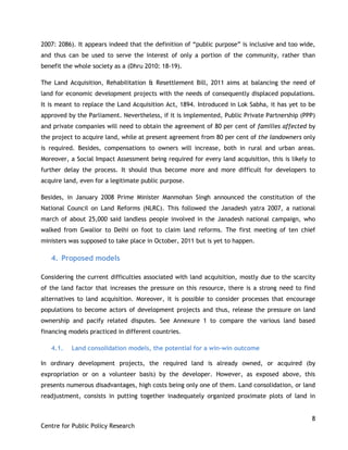
![Blue screen-la process flow [compatibility mode]](https://cdn.slidesharecdn.com/ss_thumbnails/blue-screen-laprocessflowcompatibilitymode-110425011031-phpapp01-thumbnail.jpg?width=640&height=640&fit=bounds)