inventario de los trabajos desarrollados con la RSS-NMR por varias parte del mundo RESUMEN TECNOLOGIA RSS-NMR
Cómo funciona la tecnología RSS-NMR comparada con la sísmica tradicional:
1) Dos técnicas diferentes que no compiten en nada
• SISMICA (reflexión de anomalías)
• RSS-NMR (re emisión de señal de la sustancia que se busca – resonancia).
La resonancia magnética realizada en el área médica, tiene una ligera diferencia con la que se utiliza.
• RSS es el proceso de resonancia de imágenes espaciales en un reactor nuclear,
• NMR es el proceso de resonancia en el campo petrolífero.
Human emissions of sulfur dioxide from burning coal cooled the Earth between 1940 and 1970 by reflecting sunlight. Sulfur dioxide forms sulfate aerosols in the atmosphere that have a cooling effect, counteracting the warming impact of increasing greenhouse gases like carbon dioxide and methane over that period. While greenhouse gases have continued rising, regulations have reduced sulfur dioxide emissions, removing the cooling impact of aerosols and allowing the surface temperature to rise in response to increased heat-trapping in the atmosphere.
150216_НАК Надра_Конференция _eng - final 5Igor Zaitsev
National Joint Stock Company “Nadra Ukrayny” manages Ukraine's state geological enterprises and has explored 350 oil and gas deposits. However, Ukraine's energy industry requires legal and tax reforms to attract more investment for developing conventional and unconventional reserves. Three new investment projects were proposed: 1) Developing the Oleska unconventional gas block in Western Ukraine, 2) Providing state-guaranteed loans for seismic surveys and exploration drilling of 7 new areas, and 3) Beginning oil shale production at the large Boltysh deposit and constructing a new power plant. These projects could significantly increase Ukraine's energy independence if the new government implements reforms to support the country's energy industry.
NARIIN GOL GOLD MINE PRESENTATION 12.04.2016Ivaylo Velikov
The Nariin Gol (Narrow River) Gold Mine project consists of two existing mining licenses located in Tuv Aimag, Mongolia near the Tuul River. Exploration has identified around 80 gold-bearing veins in the area, with reserves of approximately 20.3 tons estimated from exploration of two veins so far. Planned work over nine months includes geological mapping, geophysics, drilling 5,230 meters of core, resource estimation, and permitting to further explore and define the deposits. Total anticipated costs are estimated at $25 million.
Michael Bowen has built a career in business development, marketing, and helping others to develop and explode their communication and thinking skills. As a consultant, Michael Bowen Oil and Gas investments providing biggest advantages of tax deductions.
This document provides a partial review of various technologies and their application results. It summarizes the use of 6 technologies: STeP, MDI, NAGS/AGS, HEM-IP, BHSS, and an unnamed mineral finding technology. For each, it outlines case studies where the technology was successfully used to locate oil and gas deposits, increase production, or find minerals for clients around the world. The reviews are intended to demonstrate the technologies' effectiveness in helping companies explore for and develop resource prospects.
The Geological Survey of Pakistan is responsible for studying Pakistan's geology and assessing its resource potential. It undertakes geological mapping, research, and investigations to understand the country's geological resources and support their management. It aims to expedite data publication, complete geological mapping, establish an open file system for investors, and develop the Geodata Centre of Pakistan. The GSP has completed reconnaissance mapping, systematic mapping, geophysical and geochemical surveys. It has also drilled many boreholes. Notable achievements include discoveries like the Dilband iron, Duddar-Gunga-Surmai lead-zinc, Saindak and Reko Diq copper-gold deposits, and delineation of the large Thar coal deposit.
1. Prospecting work was conducted at the Utegen small gold deposit in Kazakhstan, including 701 cubic meters of trenches and 899.4 meters of core exploratory drilling.
2. Gold-silver mineralization is concentrated in quartz veins and zones within an effusive-subvolcanic complex, with disseminated gold also found in thin quartz veins and metasomatites.
3. Despite some ambiguous drilling results, quartz-vein zones could contain 10-20 grams of gold per ton, and crushed samples indicate the host metasomatites may also contain gold mineralization. Further prospecting over 50 square kilometers is recommended.
How Albanian legislation facilitates the exploration and development of hydro...Albania Energy Association
Presentation: How Albanian legislation facilitates the exploration and development of hydrocarbons
Dael Dervishi, Executive Director, National Agency of Natural Resources (AKBN)
Black Sea: An Other Caspian?
The oil and gas potential of Black SEa makes it the hottest frontier water area to be explored with a lot of challenges. However; the potential she offers makes those challenges bearable . They were once together with Caspian Sea....
June 2021 - Sonoro Gold - Summary Cerro Caliche FocusMomentumPR
Sonoro Gold is a publicly listed exploration and development company with a portfolio of exploration-stage precious metal properties in Sonora state, Mexico. The company has highly experienced operational and management teams with proven records for the discovery and development of natural resource deposits.
Core Assets: Exceeding expectations with high grades of silver, copper, zinc,...Stephan Bogner
As a result of “encouraging visual observations“ during its phase-1- and phase-2 sampling programs, Core Assets Corp. last week announced the expansion (quadruplication to 1083 km2) of its 100% owned, royalty-free Blue Property at the northern edge of the Golden Triangle in British Columbia (BC), Canada. The news was followed by a Rockstone report highlighting the chances of making a CRD (Carbonate Replacement Deposit) discovery and explaining the significance of CRDs in comparison with other types of polymetallic deposits such as VMS and MVT. Today, Core Assets Corp. released assays from its recently completed phase-1 grab-sampling program, when 247 grab samples were collected.
This document provides a technical overview of petroleum exploration and development activities in the Joint Petroleum Development Area (JPDA) between Timor-Leste and Australia. It summarizes that over 50,000 km of seismic data and 46 wells have been drilled, leading to 9 significant oil and gas discoveries. The Bayu-Undan gas field has been producing since 2004 via a gas recycling project and pipeline to Darwin, while other fields like Elang-Kakatua-Kakatua North have also seen production. Four blocks are currently being promoted for new exploration, with proven petroleum systems and existing seismic data but many remaining untested structures.
The document provides a cautionary statement regarding forward-looking information in the presentation. It states that certain statements in the presentation other than historical information constitute forward-looking statements that involve risks and uncertainties. These risks include the inherent risks involved in mineral exploration and development as well as fluctuating metal prices and uncertainties around costs and financing. The company disclaims any obligation to update forward-looking statements if circumstances change.
A remote survey was conducted off the coast of the Indian Ocean in two stages over 2 months. The first stage identified 4 potential oil and gas deposits, with one 6.9 square km deposit showing commercial potential. The second stage performed deeper scans of this deposit, revealing multiple natural gas horizons at different depths as well as a thick oil zone with good porosity and excess pressure. Fault zones and signal responses were mapped to further evaluate the promising deposit.
The document summarizes the success of lineament analysis techniques developed by Dr. Vadim Galkine and Ricardo Valls over 15 years. Their techniques identified known mineral deposits in blind tests and reduced exploration areas. Their targets were confirmed by clients' drilling and surveys. Examples show their techniques located gold and copper deposits, kimberlites, oil/gas fields, uranium and emeralds in Canada, US, Mexico, Peru and other countries. Their lineament analysis involves structural mapping, physical modeling and integrating diverse datasets to generate exploration targets.
Kenex have been working with Duke Exploration in order to develop exploration targets for base and precious metal mineralisation in Australia. We have been involved throughout all stages of the exploration workflow, details of which are provided below. The Bundarra project represents one of the most successful exploration targeting projects that Kenex has been involved with and promises to be even more exciting in the future!
Scientists led by researchers from the UK and France plan to drill down over 5 miles through the Earth's crust and into the mantle, a feat that has never been accomplished before. Drilling so deep presents enormous challenges, including temperatures over 1000 degrees Fahrenheit, extreme pressures, and the need to retrieve samples without contamination. The researchers hope to begin searching for a suitable drilling site in the Pacific Ocean in 2018.
Protocol about report of gold mine Mialy in Kazakhstan[820].pdfPartnersInvestors
This document is a report presented to the State Commission on mineral reserves of Kazakhstan regarding an assessment of technogenic mineral formations dumps at the Miyaly gold deposit. It summarizes the results of an exploration program that classified 1864 thousand tons of gold-bearing ore with 849 kg of gold as category C1 reserves. Inferred resources of 2441 thousand tons were also estimated with 1153 kg of gold. Technical and economic analyses found developing these dumps would be profitable with a 36.45% internal rate of return and 3.4 year payback period. The Commission concluded the report and exploration methods met requirements and the calculated reserves and development preparedness were acceptable.
The document provides an overview and history of exploration activities for the OK Property in British Columbia, which Prophecy Resource Corp. has an option to earn a 60% interest in. Key points include:
- Prophecy acquired an option to earn a 60% interest in the OK Property from Eastfield Resource Corp. in 2006 and has since conducted exploration programs including soil sampling, road construction, and drilling.
- The OK Property has a long history of exploration dating back to the 1960s, with over 14,000m of drilling and various geophysical and geochemical surveys conducted by multiple companies.
- Prophecy's most recent work in 2006 expanded road access and located drill sites from previous campaigns, with
This document summarizes the proceedings of a conference on sandstone uranium deposits. It notes that 105 participants from various countries attended and 45 papers were presented over 3.5 days covering major uranium districts around the world. Key points from the discussions include the control of uranium deposition in specific climatic conditions and basins, the role of migrated organic matter in uranium reduction, advances in exploration methods using geophysics and isotopes, and an overview of major uranium provinces and resources. The proposed organization of a technical document on sandstone uranium deposits is also included, structured to provide an overview of the systems and deposits, case studies on key regions, and summaries of exploration advances, production, and resources.
Minaurum Gold is a mineral exploration company focused on projects in Mexico's Guerrero Gold Belt. Key points:
- Minaurum has a portfolio of 7 drill-ready projects located near multi-million ounce gold deposits in the prolific Guerrero Gold Belt.
- Their flagship project, Vuelcos del Destino, is located 20km from Goldcorp's 7.75M oz Los Filos mine and covers similar geology. Permitting is underway for a 7,500m drill program.
- Other projects include the Aurena gold project with identified gold zones up to 1.8km long and the Adelita copper-gold project with drill results including 105.2m
Minaurum Gold is a junior exploration company focused on gold and copper exploration in Mexico. It has a portfolio of 7 drill-ready projects located in prolific mining districts. Its flagship project, Vuelcos del Destino, covers 18,200 hectares in the emerging Guerrero Gold Belt where over 21 million ounces of gold have been discovered. Minaurum was the first to acquire land in the underexplored southern region of the belt and has identified targets near existing large gold mines. The company plans to begin its first drill program at Vuelcos del Destino in summer 2013 once permits are received to test priority targets along structures known to host gold deposits in the district.
- The document discusses oil and gas exploration prospects in western Greece and offshore Crete. It analyzes geological data from existing wells and seismic surveys that indicate the presence of working petroleum systems in both areas.
- Significant challenges for exploration include drilling through thick evaporite sequences that can cause high pressures, and a lack of seismic data offshore Crete.
- Greek universities have relevant expertise in geophysics, drilling, reservoir modeling, and other disciplines that could provide scientific support for future exploration activities. However, more data from seismic campaigns and information sharing about recent regional drilling problems would help reduce risks and uncertainties.
Minaurum Gold is a mineral exploration company focused on projects in Mexico's Guerrero Gold Belt. They have a first mover advantage as one of the first explorers in the southern Guerrero Gold Belt, which hosts over 21 million ounces of gold. Their key projects include Vuelcos del Destino, located 20km from Goldcorp's multi-million ounce Los Filos Mine. They plan to begin a 7,500m drilling program at Vuelcos pending permit approval. They also have copper and gold projects including Adelita, a copper porphyry project, and Aurena, a gold project. Minaurum is led by an experienced management team involved with numerous past discoveries and has no
Los problemas de suministro de agua en el mundo están empeorando cada día . Este
problema es particularmente relevante para los países de climá áridos y los desiertos que
ocupan grandes áreas.
El desarrollo y la aplicación de métodos precisos, rápidos y económicos para la búsqueda
de aguas subterráneas en grandes áreas y horizontes profundas es relevante en estos
momentos de cambios climáticos.
Los científicos de nuestra empresa han desarrollado y aplicado con éxito la tecnología de
investigación directa de los recursos de aguas subterráneas, esto se basa en el efecto de
la resonancia desde las profundidades con una investigación hasta 7 kilómetros!
El uso de nuestras tecnologías combinadas (RSS - RNM) permite explorar en grandes
territorios muy difíciles de explorar (hasta un millón de km2 en muy poco tiempo). Se
resaltan los reservorios profundos y se identifican puntos de perforación óptimos
Utilizamos la destilación natural de corrientes de agua salada por la cámarasde tipo
Magma que reproducen un sistema quieto de distilacion pero de forma natural.
1. El desarrollo de un enfoque científico para la génesis de las aguas subterráneas.
2. Proyectos de investigación de agua dulce con 100 % en varios países.
3. La presencia de tecnología de exploración de aguas subterráneas altamente
eficiente.
Nuestro éxito se basa en tres factores clave3. Enfoque científico para la formación de aguas subterráneas
artesianas
3. Enfoque científico para la formación de aguas subterráneas artesianas
El petróleo (del griego: πετρέλαιον, lit. «aceite de roca») es una mezcla de compuestos orgánicos, principalmente hidrocarburos insolubles en agua. También es conocido como oro negro, petróleo crudo o simplemente crudo.
Se produce en el interior de la Tierra, por transformación de la materia orgánica acumulada en sedimentos del pasado geológico1 y puede acumularse en trampas geológicas naturales, que se localizan a nivel mundial2 y de donde se extrae mediante la perforación de pozos.
En condiciones normales de presión y temperatura es un líquido bituminoso que puede presentar gran variación en diversos parámetros como color y viscosidad (desde amarillentos y poco viscosos como la gasolina hasta líquidos negros tan viscosos que apenas fluyen), densidad (entre 0,66 g/ml y 0,9785 g/ml), capacidad calorífica, etc. Estas variaciones se deben a la diversidad de concentraciones de los hidrocarburos que componen la mezcla, esto hace que el petróleo de cada pozo o fuente sea distinto de otro.
Es un recurso no renovable y actualmente también es la principal fuente de energía y materia prima para la generación de una gran variedad de derivados, entre los que se incluyen la mayoría de los plásticos. El petróleo líquido puede presentarse asociado a capas de gas natural, en yacimientos que han estado enterrados durante millones de años, cubiertos por los estratos superiores de la corteza terrestre.
Debido a la importancia fundamental como materia prima, la venta del petróleo y sus derivados es un pilar fundamental del mercado mundial y la política exterior de varios países.
En los Estados Unidos, es común medir los volúmenes de petróleo líquido en barriles (de 42 galones estadounidenses, equivalente a 158,987 litros), y los volúmenes de gas en pies cúbicos (equivalente a 28,317 litros); en otras regiones ambos volúmenes se miden en metros cúbicos.
More Related Content
Similar to Experiencia ing geodirect al 2020 principales trabajos
Black Sea: An Other Caspian?
The oil and gas potential of Black SEa makes it the hottest frontier water area to be explored with a lot of challenges. However; the potential she offers makes those challenges bearable . They were once together with Caspian Sea....
June 2021 - Sonoro Gold - Summary Cerro Caliche FocusMomentumPR
Sonoro Gold is a publicly listed exploration and development company with a portfolio of exploration-stage precious metal properties in Sonora state, Mexico. The company has highly experienced operational and management teams with proven records for the discovery and development of natural resource deposits.
Core Assets: Exceeding expectations with high grades of silver, copper, zinc,...Stephan Bogner
As a result of “encouraging visual observations“ during its phase-1- and phase-2 sampling programs, Core Assets Corp. last week announced the expansion (quadruplication to 1083 km2) of its 100% owned, royalty-free Blue Property at the northern edge of the Golden Triangle in British Columbia (BC), Canada. The news was followed by a Rockstone report highlighting the chances of making a CRD (Carbonate Replacement Deposit) discovery and explaining the significance of CRDs in comparison with other types of polymetallic deposits such as VMS and MVT. Today, Core Assets Corp. released assays from its recently completed phase-1 grab-sampling program, when 247 grab samples were collected.
This document provides a technical overview of petroleum exploration and development activities in the Joint Petroleum Development Area (JPDA) between Timor-Leste and Australia. It summarizes that over 50,000 km of seismic data and 46 wells have been drilled, leading to 9 significant oil and gas discoveries. The Bayu-Undan gas field has been producing since 2004 via a gas recycling project and pipeline to Darwin, while other fields like Elang-Kakatua-Kakatua North have also seen production. Four blocks are currently being promoted for new exploration, with proven petroleum systems and existing seismic data but many remaining untested structures.
The document provides a cautionary statement regarding forward-looking information in the presentation. It states that certain statements in the presentation other than historical information constitute forward-looking statements that involve risks and uncertainties. These risks include the inherent risks involved in mineral exploration and development as well as fluctuating metal prices and uncertainties around costs and financing. The company disclaims any obligation to update forward-looking statements if circumstances change.
A remote survey was conducted off the coast of the Indian Ocean in two stages over 2 months. The first stage identified 4 potential oil and gas deposits, with one 6.9 square km deposit showing commercial potential. The second stage performed deeper scans of this deposit, revealing multiple natural gas horizons at different depths as well as a thick oil zone with good porosity and excess pressure. Fault zones and signal responses were mapped to further evaluate the promising deposit.
The document summarizes the success of lineament analysis techniques developed by Dr. Vadim Galkine and Ricardo Valls over 15 years. Their techniques identified known mineral deposits in blind tests and reduced exploration areas. Their targets were confirmed by clients' drilling and surveys. Examples show their techniques located gold and copper deposits, kimberlites, oil/gas fields, uranium and emeralds in Canada, US, Mexico, Peru and other countries. Their lineament analysis involves structural mapping, physical modeling and integrating diverse datasets to generate exploration targets.
Kenex have been working with Duke Exploration in order to develop exploration targets for base and precious metal mineralisation in Australia. We have been involved throughout all stages of the exploration workflow, details of which are provided below. The Bundarra project represents one of the most successful exploration targeting projects that Kenex has been involved with and promises to be even more exciting in the future!
Scientists led by researchers from the UK and France plan to drill down over 5 miles through the Earth's crust and into the mantle, a feat that has never been accomplished before. Drilling so deep presents enormous challenges, including temperatures over 1000 degrees Fahrenheit, extreme pressures, and the need to retrieve samples without contamination. The researchers hope to begin searching for a suitable drilling site in the Pacific Ocean in 2018.
Protocol about report of gold mine Mialy in Kazakhstan[820].pdfPartnersInvestors
This document is a report presented to the State Commission on mineral reserves of Kazakhstan regarding an assessment of technogenic mineral formations dumps at the Miyaly gold deposit. It summarizes the results of an exploration program that classified 1864 thousand tons of gold-bearing ore with 849 kg of gold as category C1 reserves. Inferred resources of 2441 thousand tons were also estimated with 1153 kg of gold. Technical and economic analyses found developing these dumps would be profitable with a 36.45% internal rate of return and 3.4 year payback period. The Commission concluded the report and exploration methods met requirements and the calculated reserves and development preparedness were acceptable.
The document provides an overview and history of exploration activities for the OK Property in British Columbia, which Prophecy Resource Corp. has an option to earn a 60% interest in. Key points include:
- Prophecy acquired an option to earn a 60% interest in the OK Property from Eastfield Resource Corp. in 2006 and has since conducted exploration programs including soil sampling, road construction, and drilling.
- The OK Property has a long history of exploration dating back to the 1960s, with over 14,000m of drilling and various geophysical and geochemical surveys conducted by multiple companies.
- Prophecy's most recent work in 2006 expanded road access and located drill sites from previous campaigns, with
This document summarizes the proceedings of a conference on sandstone uranium deposits. It notes that 105 participants from various countries attended and 45 papers were presented over 3.5 days covering major uranium districts around the world. Key points from the discussions include the control of uranium deposition in specific climatic conditions and basins, the role of migrated organic matter in uranium reduction, advances in exploration methods using geophysics and isotopes, and an overview of major uranium provinces and resources. The proposed organization of a technical document on sandstone uranium deposits is also included, structured to provide an overview of the systems and deposits, case studies on key regions, and summaries of exploration advances, production, and resources.
Minaurum Gold is a mineral exploration company focused on projects in Mexico's Guerrero Gold Belt. Key points:
- Minaurum has a portfolio of 7 drill-ready projects located near multi-million ounce gold deposits in the prolific Guerrero Gold Belt.
- Their flagship project, Vuelcos del Destino, is located 20km from Goldcorp's 7.75M oz Los Filos mine and covers similar geology. Permitting is underway for a 7,500m drill program.
- Other projects include the Aurena gold project with identified gold zones up to 1.8km long and the Adelita copper-gold project with drill results including 105.2m
Minaurum Gold is a mineral exploration company focused on projects in Mexico's Guerrero Gold Belt. Key points:
- Minaurum has a portfolio of 7 drill-ready projects located near multi-million ounce gold deposits in the prolific Guerrero Gold Belt.
- Their flagship project, Vuelcos del Destino, is located 20km from Goldcorp's 7.75M oz Los Filos mine and covers similar geology. Permitting is underway for a 7,500m drill program.
- Other projects include the Aurena gold project with identified gold zones up to 1.8km long and the Adelita copper-gold project with drill results including 105.2m
Minaurum Gold is a junior exploration company focused on gold and copper exploration in Mexico. It has a portfolio of 7 drill-ready projects located in prolific mining districts. Its flagship project, Vuelcos del Destino, covers 18,200 hectares in the emerging Guerrero Gold Belt where over 21 million ounces of gold have been discovered. Minaurum was the first to acquire land in the underexplored southern region of the belt and has identified targets near existing large gold mines. The company plans to begin its first drill program at Vuelcos del Destino in summer 2013 once permits are received to test priority targets along structures known to host gold deposits in the district.
- The document discusses oil and gas exploration prospects in western Greece and offshore Crete. It analyzes geological data from existing wells and seismic surveys that indicate the presence of working petroleum systems in both areas.
- Significant challenges for exploration include drilling through thick evaporite sequences that can cause high pressures, and a lack of seismic data offshore Crete.
- Greek universities have relevant expertise in geophysics, drilling, reservoir modeling, and other disciplines that could provide scientific support for future exploration activities. However, more data from seismic campaigns and information sharing about recent regional drilling problems would help reduce risks and uncertainties.
Minaurum Gold is a mineral exploration company focused on projects in Mexico's Guerrero Gold Belt. They have a first mover advantage as one of the first explorers in the southern Guerrero Gold Belt, which hosts over 21 million ounces of gold. Their key projects include Vuelcos del Destino, located 20km from Goldcorp's multi-million ounce Los Filos Mine. They plan to begin a 7,500m drilling program at Vuelcos pending permit approval. They also have copper and gold projects including Adelita, a copper porphyry project, and Aurena, a gold project. Minaurum is led by an experienced management team involved with numerous past discoveries and has no
Similar to Experiencia ing geodirect al 2020 principales trabajos (20)
Los problemas de suministro de agua en el mundo están empeorando cada día . Este
problema es particularmente relevante para los países de climá áridos y los desiertos que
ocupan grandes áreas.
El desarrollo y la aplicación de métodos precisos, rápidos y económicos para la búsqueda
de aguas subterráneas en grandes áreas y horizontes profundas es relevante en estos
momentos de cambios climáticos.
Los científicos de nuestra empresa han desarrollado y aplicado con éxito la tecnología de
investigación directa de los recursos de aguas subterráneas, esto se basa en el efecto de
la resonancia desde las profundidades con una investigación hasta 7 kilómetros!
El uso de nuestras tecnologías combinadas (RSS - RNM) permite explorar en grandes
territorios muy difíciles de explorar (hasta un millón de km2 en muy poco tiempo). Se
resaltan los reservorios profundos y se identifican puntos de perforación óptimos
Utilizamos la destilación natural de corrientes de agua salada por la cámarasde tipo
Magma que reproducen un sistema quieto de distilacion pero de forma natural.
1. El desarrollo de un enfoque científico para la génesis de las aguas subterráneas.
2. Proyectos de investigación de agua dulce con 100 % en varios países.
3. La presencia de tecnología de exploración de aguas subterráneas altamente
eficiente.
Nuestro éxito se basa en tres factores clave3. Enfoque científico para la formación de aguas subterráneas
artesianas
3. Enfoque científico para la formación de aguas subterráneas artesianas
El petróleo (del griego: πετρέλαιον, lit. «aceite de roca») es una mezcla de compuestos orgánicos, principalmente hidrocarburos insolubles en agua. También es conocido como oro negro, petróleo crudo o simplemente crudo.
Se produce en el interior de la Tierra, por transformación de la materia orgánica acumulada en sedimentos del pasado geológico1 y puede acumularse en trampas geológicas naturales, que se localizan a nivel mundial2 y de donde se extrae mediante la perforación de pozos.
En condiciones normales de presión y temperatura es un líquido bituminoso que puede presentar gran variación en diversos parámetros como color y viscosidad (desde amarillentos y poco viscosos como la gasolina hasta líquidos negros tan viscosos que apenas fluyen), densidad (entre 0,66 g/ml y 0,9785 g/ml), capacidad calorífica, etc. Estas variaciones se deben a la diversidad de concentraciones de los hidrocarburos que componen la mezcla, esto hace que el petróleo de cada pozo o fuente sea distinto de otro.
Es un recurso no renovable y actualmente también es la principal fuente de energía y materia prima para la generación de una gran variedad de derivados, entre los que se incluyen la mayoría de los plásticos. El petróleo líquido puede presentarse asociado a capas de gas natural, en yacimientos que han estado enterrados durante millones de años, cubiertos por los estratos superiores de la corteza terrestre.
Debido a la importancia fundamental como materia prima, la venta del petróleo y sus derivados es un pilar fundamental del mercado mundial y la política exterior de varios países.
En los Estados Unidos, es común medir los volúmenes de petróleo líquido en barriles (de 42 galones estadounidenses, equivalente a 158,987 litros), y los volúmenes de gas en pies cúbicos (equivalente a 28,317 litros); en otras regiones ambos volúmenes se miden en metros cúbicos.
Exploracion petrolera varias tecnicas antiguas antes de la RSS NMRexplorationsismica
La cadena del sector hidrocarburos corresponde al conjunto de actividades económicas relacionadas con la exploración, producción, transporte, refinación o procesamiento y comercialización de los recursos naturales no renovables conocidos como hidrocarburos (material orgánico compuesto principalmente por hidrógeno y carbono), dicho conjunto también está conformado por la regulación y administración de estas actividades.
La Cadena de Valor de los hidrocarburos, consta de dos grandes áreas: Upstream y Downstream.Exploración Sísmica: Proceso mediante el cual ondas de energía atraviesan las capas de roca, se devuelven hasta la superficie y llegan a unos equipos especiales que se llaman geófonos, los cuales reciben la información y la transmiten a un computador. El producto final que se obtiene de la exploración sísmica es una imagen representativa de las capas que hay debajo de la tierra. (ANH). Exploración Perforatoria:Consiste en la perforación de pozos, cuya finalidad es llegar hasta la capa de roca donde posiblemente se pudieron acumular los hidrocarburos (petróleo y gas). Esta etapa inicia por lo general, después de que se obtiene la información del estudio sísmico.
La tecnología RSS-NMR ofrece una solución innovadora para la exploración de hidrocarburos y otros recursos naturales. Combina dos métodos, RSS para la topografía remota de territorios y RMN para el trabajo de campo. Esto permite realizar un diagnóstico rápido del territorio, una búsqueda detallada de depósitos e identificar puntos de perforación con una efectividad superior al 90%. Esto reduce significativamente los riesgos financieros en comparación con los métodos tradicionales.
Nuclear Magnetic Resonance Comes Out of Its Shell
Ridvan Akkurt Saudi Aramco Dhahran, Saudi Arabia
H. Nate Bachman
Chanh Cao Minh
Charles Flaum
Jack LaVigne
Rob Leveridge
Sugar Land, Texas, USA
Romulo Carmona
Petróleos de Venezuela S.A.
Caracas, Venezuela
Advances in measurement technology, along with improved processing techniques,
have created new applicationsfor nuclear magnetic resonance (NMR) logging. A new
NMR tool delivers conventional NMR-based information as well as fluid-property
characterization. These NMR data identify fluid types, transition zones and production
potential in complex environments. Placing this information into multidimensional
visualization maps provides log analysts with new insight into in situ fluid properties.
referencia de trabajos hechos en el mundo tanto en petróleo y gas, que aguas, mineral, gemas y otros problemas
1.2. ¿Cómo funciona la tecnología RSS-NMR?
1. El transmisor envía una señal estrechamente direccional típica solo de la sustancia que se busca (petróleo, gas), es decir, se incluye información sobre el petróleo o el gas en la señal.
2. Una vez que la señal llega al petróleo o al gas, la señal informativa penetra en el interior de la sustancia buscada y de inmediato revela este depósito (petróleo, gas, minerales, etc.) vuelve a emerger y percibimos la información sobre el petróleo o el gas y con confianza en la superficie sabemos que hemos alcanzado al objetivo.
A esto se le llama resonancia del material que se busca, por lo tanto, no necesitamos interpretación, este es el descubrimiento directo de un depósito. La precisión es del 90-95%, por este motivo la exploración con esta tecnología es realiza en un tiempo muy corto de 15 a 30 días.
1.2.1. Alcance del Proyecto RSS-NMR
Se tienen dos etapas:
• ETAPA 1: Es el método RSS, que es remoto; recibimos datos de resonancia de imágenes espaciales en un reactor nuclear en Ucrania. La precisión es del 85-90%, que es tres veces mayor en comparación con la sísmica.
• Todo se hace a Kiev, Ucrania, por eso y de forma remota, no se gasta tiempo y energía en la parte administrativa y para la captura de los datos en el bloque a explorar. Se hace de una forma discreta sin crear alborotes en la zona y protestas cualquiera
• ETAPA 2: Es un estudio de campo de NMR que se realiza con un equipo reducido. La precisión del trabajo es del 95%. ver el siguiente video https://youtu.be/EsITieoHDSQ etapa dos de campos y conclusiones.
Con este trabajo se tiene reducción de costos además de una precisión que supera los 90 %.
Las técnicas sísmicas se basan en la excitación de ondas elásticas (acústicas) utilizando dispositivos técnicos de choque o
explosión. El dispositivo de medición básico en un levantamiento sísmico es un receptor sísmico, que convierte la
vibración mecánica de las ondas elásticas en una corriente eléctrica de voltaje variable. A medida que las partículas de
roca se mueven alrededor del receptor, genera pulsos eléctricos que se amplifican, filtran, digitalizan y transmiten al
complejo de medición de información de la estación sísmica.
Dado que la propagación de ondas elásticas bajo tierra depende solo de las propiedades de los estratos rocosos, solo la
electrónica de los receptores sísmicos puede ser distorsionada por los procesos de anomalía magnética del Atlántico sur
y en las etapas de procesamiento de señales eléctricas. No somos especialistas en este campo, por lo que este es solo
una teoría que requiere una verificación experimental.
NUCLEAR MAGNETIC RESONANCE TO USE IN ANALYSIS OF
PETROPHYSICAL PARAMETERS OF ROCKS
Edyta Puskarczyk
The University of Science and Technology, Faculty of Geology, Geophysics and
Environmental Protection, Department of Geophysics; e-mail: puskarczyk@geol.agh.edu.pl
The phenomenon of nuclear magnetic resonance has become a valuable tool in applied
geophysics, because of significant progress in computer technology. Using NMR as a
laboratory study with cores analysis and well-logging has been permitted to get information
about rocks, inaccessible with other methods. It allows to evaluate the several parameters as:
porosity, volume of water saturated pore space included clay bound water, capillary bound water and crystalline water of hydration, such as in gypsum - CaSO4*2H2O, permeability, pore size, oil viscosity
Comparative analysis between traditional aquaponics and reconstructed aquapon...bijceesjournal
The aquaponic system of planting is a method that does not require soil usage. It is a method that only needs water, fish, lava rocks (a substitute for soil), and plants. Aquaponic systems are sustainable and environmentally friendly. Its use not only helps to plant in small spaces but also helps reduce artificial chemical use and minimizes excess water use, as aquaponics consumes 90% less water than soil-based gardening. The study applied a descriptive and experimental design to assess and compare conventional and reconstructed aquaponic methods for reproducing tomatoes. The researchers created an observation checklist to determine the significant factors of the study. The study aims to determine the significant difference between traditional aquaponics and reconstructed aquaponics systems propagating tomatoes in terms of height, weight, girth, and number of fruits. The reconstructed aquaponics system’s higher growth yield results in a much more nourished crop than the traditional aquaponics system. It is superior in its number of fruits, height, weight, and girth measurement. Moreover, the reconstructed aquaponics system is proven to eliminate all the hindrances present in the traditional aquaponics system, which are overcrowding of fish, algae growth, pest problems, contaminated water, and dead fish.
KuberTENes Birthday Bash Guadalajara - K8sGPT first impressionsVictor Morales
K8sGPT is a tool that analyzes and diagnoses Kubernetes clusters. This presentation was used to share the requirements and dependencies to deploy K8sGPT in a local environment.
Harnessing WebAssembly for Real-time Stateless Streaming PipelinesChristina Lin
Traditionally, dealing with real-time data pipelines has involved significant overhead, even for straightforward tasks like data transformation or masking. However, in this talk, we’ll venture into the dynamic realm of WebAssembly (WASM) and discover how it can revolutionize the creation of stateless streaming pipelines within a Kafka (Redpanda) broker. These pipelines are adept at managing low-latency, high-data-volume scenarios.
DEEP LEARNING FOR SMART GRID INTRUSION DETECTION: A HYBRID CNN-LSTM-BASED MODELgerogepatton
As digital technology becomes more deeply embedded in power systems, protecting the communication
networks of Smart Grids (SG) has emerged as a critical concern. Distributed Network Protocol 3 (DNP3)
represents a multi-tiered application layer protocol extensively utilized in Supervisory Control and Data
Acquisition (SCADA)-based smart grids to facilitate real-time data gathering and control functionalities.
Robust Intrusion Detection Systems (IDS) are necessary for early threat detection and mitigation because
of the interconnection of these networks, which makes them vulnerable to a variety of cyberattacks. To
solve this issue, this paper develops a hybrid Deep Learning (DL) model specifically designed for intrusion
detection in smart grids. The proposed approach is a combination of the Convolutional Neural Network
(CNN) and the Long-Short-Term Memory algorithms (LSTM). We employed a recent intrusion detection
dataset (DNP3), which focuses on unauthorized commands and Denial of Service (DoS) cyberattacks, to
train and test our model. The results of our experiments show that our CNN-LSTM method is much better
at finding smart grid intrusions than other deep learning algorithms used for classification. In addition,
our proposed approach improves accuracy, precision, recall, and F1 score, achieving a high detection
accuracy rate of 99.50%.
Electric vehicle and photovoltaic advanced roles in enhancing the financial p...IJECEIAES
Climate change's impact on the planet forced the United Nations and governments to promote green energies and electric transportation. The deployments of photovoltaic (PV) and electric vehicle (EV) systems gained stronger momentum due to their numerous advantages over fossil fuel types. The advantages go beyond sustainability to reach financial support and stability. The work in this paper introduces the hybrid system between PV and EV to support industrial and commercial plants. This paper covers the theoretical framework of the proposed hybrid system including the required equation to complete the cost analysis when PV and EV are present. In addition, the proposed design diagram which sets the priorities and requirements of the system is presented. The proposed approach allows setup to advance their power stability, especially during power outages. The presented information supports researchers and plant owners to complete the necessary analysis while promoting the deployment of clean energy. The result of a case study that represents a dairy milk farmer supports the theoretical works and highlights its advanced benefits to existing plants. The short return on investment of the proposed approach supports the paper's novelty approach for the sustainable electrical system. In addition, the proposed system allows for an isolated power setup without the need for a transmission line which enhances the safety of the electrical network
Use PyCharm for remote debugging of WSL on a Windo cf5c162d672e4e58b4dde5d797...shadow0702a
This document serves as a comprehensive step-by-step guide on how to effectively use PyCharm for remote debugging of the Windows Subsystem for Linux (WSL) on a local Windows machine. It meticulously outlines several critical steps in the process, starting with the crucial task of enabling permissions, followed by the installation and configuration of WSL.
The guide then proceeds to explain how to set up the SSH service within the WSL environment, an integral part of the process. Alongside this, it also provides detailed instructions on how to modify the inbound rules of the Windows firewall to facilitate the process, ensuring that there are no connectivity issues that could potentially hinder the debugging process.
The document further emphasizes on the importance of checking the connection between the Windows and WSL environments, providing instructions on how to ensure that the connection is optimal and ready for remote debugging.
It also offers an in-depth guide on how to configure the WSL interpreter and files within the PyCharm environment. This is essential for ensuring that the debugging process is set up correctly and that the program can be run effectively within the WSL terminal.
Additionally, the document provides guidance on how to set up breakpoints for debugging, a fundamental aspect of the debugging process which allows the developer to stop the execution of their code at certain points and inspect their program at those stages.
Finally, the document concludes by providing a link to a reference blog. This blog offers additional information and guidance on configuring the remote Python interpreter in PyCharm, providing the reader with a well-rounded understanding of the process.
Advanced control scheme of doubly fed induction generator for wind turbine us...IJECEIAES
This paper describes a speed control device for generating electrical energy on an electricity network based on the doubly fed induction generator (DFIG) used for wind power conversion systems. At first, a double-fed induction generator model was constructed. A control law is formulated to govern the flow of energy between the stator of a DFIG and the energy network using three types of controllers: proportional integral (PI), sliding mode controller (SMC) and second order sliding mode controller (SOSMC). Their different results in terms of power reference tracking, reaction to unexpected speed fluctuations, sensitivity to perturbations, and resilience against machine parameter alterations are compared. MATLAB/Simulink was used to conduct the simulations for the preceding study. Multiple simulations have shown very satisfying results, and the investigations demonstrate the efficacy and power-enhancing capabilities of the suggested control system.
The CBC machine is a common diagnostic tool used by doctors to measure a patient's red blood cell count, white blood cell count and platelet count. The machine uses a small sample of the patient's blood, which is then placed into special tubes and analyzed. The results of the analysis are then displayed on a screen for the doctor to review. The CBC machine is an important tool for diagnosing various conditions, such as anemia, infection and leukemia. It can also help to monitor a patient's response to treatment.
gray level transformation unit 3(image processing))
Experiencia ing geodirect al 2020 principales trabajos
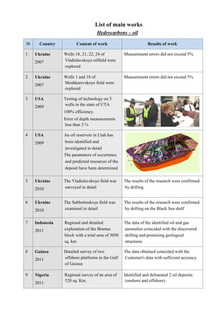
1. № Country Content of work
1 Ukraine
2007
Wells 18, 21, 22, 24 of
Vladislavskoye oilfield were
explored
2 Ukraine
2007
Wells 1 and 18 of
Moshkarevskoye field
explored
3 USA
2009
Testing of technology on 5
wells in the state of UTA
100% efficiency.
Error of depth measurements
less than 3 %
4 USA
2009
An oil reservoir in Utah has
been identified and
investigated in
The parameters of occurrence
and predicted resources of the
deposit have been determined
5 Ukraine
2010
The Vladislavskoye field was
surveyed in detail
6 Ukraine
2010
The Subbotinskoye field was
examined in detail
7 Indonesia
2011
Regional and detailed
exploration of the Brantas
block with a total area of
sq. km
8 Guinea
2011
Detailed survey of two
offshore platforms in the Gulf
of Guinea
9 Nigeria
2011
Regional survey of an area of
520 sq. Km.
List of main works
Hydrocarbons – oil
Content of work Results of work
Wells 18, 21, 22, 24 of
Vladislavskoye oilfield were
Measurement errors did not exceed 5%
Wells 1 and 18 of
Moshkarevskoye field were
Measurement errors did not exceed 5%
Testing of technology on 5
wells in the state of UTA
100% efficiency.
Error of depth measurements
An oil reservoir in Utah has
been identified and
investigated in detail
The parameters of occurrence
and predicted resources of the
deposit have been determined
The Vladislavskoye field was
surveyed in detail
The results of the research were confirmed
by drilling
The Subbotinskoye field was
examined in detail
The results of the research were confirmed
by drilling on the Black Sea shelf
Regional and detailed
exploration of the Brantas
block with a total area of 3050
The data of the identified oil and gas
anomalies coincided with the discovered
drilling and promising geological
structures
Detailed survey of two
offshore platforms in the Gulf
The data obtained coincided with the
Customer's data with sufficient
Regional survey of an area of Identified and delineated 2 oil deposits
(onshore and offshore)
Results of work
Measurement errors did not exceed 5%
The results of the research were confirmed
by drilling on the Black Sea shelf
identified oil and gas
anomalies coincided with the discovered
drilling and promising geological
The data obtained coincided with the
Customer's data with sufficient accuracy
Identified and delineated 2 oil deposits
2. 10 Kazakhstan
2012
Regional and detailed study of
a 300 sq. km
11
Ethiopia
2012
Regional survey of the area of
3600 sq. km
12 Russia
2012
Regional survey of the area of
3600 sq. km
13 Russia
2012
Detailed remote sensing of two
oil deposits. Data of
occurrence, points for drilling
and predicted resources of the
deposit were obtained
14 Russia
2013
Preliminary remote testing of 2
drilling points in the Komi
Republic.
Drilling has shown 100%
research efficiency
15 Libya
2014
Drilling Point Remote Testing
for Al Wahha
16 Lithuania
2015
Remote testing of two drilling
points
17 Greece
2016
Regional survey of the 8350
sq. km Gas and oil deposits
were identified and delineated
on the island and on the shelf
Regional and detailed study of Identified, delineated and investigated 3 oil
deposits within the oil and gas basin
Kumkol
Regional survey of the area of 2 large oil basins have been identified and
delineated
Regional survey of the area of 2 large oil basins have been identified
delineated
Detailed remote sensing of two
oil deposits. Data of
occurrence, points for drilling
and predicted resources of the
deposit were obtained
Preliminary remote testing of 2
drilling points in the Komi
Drilling has shown 100%
research efficiency
Drilling Point Remote Testing
for Al Wahha
Research Results Confirmed by Drilling
Remote testing of two drilling Survey data and well data matched
Regional survey of the 8350
sq. km Gas and oil deposits
were identified and delineated
on the island and on the shelf
Identified, delineated and investigated 3 oil
within the oil and gas basin
2 large oil basins have been identified and
Research Results Confirmed by Drilling
Survey data and well data matched
3. 18
Mongolia
2016
A regional survey of the
license area in the east of the
country with an area of
sq. km
4 oil deposits have been
identified, contoured and
examined in detail
19
Morocco
2017
Regional survey of an area of
4200 sq. km
Highlighted a site containing a
promising oil reservoir
20
Italy
2017
Regional survey of an area of
1,500 sq. km on the
Sardinia
Highlighted a site containing a
promising oil reservoir
21
USA
2017
Remote testing of two points
for drilling in Iowa.
Recommendations and a
forecast for drilling are given
22
Kazakhstan
2018
Regional survey of a 315 sq.
km and a detailed survey of
the identified gas and oil
reservoir with an area of
km.
A regional survey of the
license area in the east of the
country with an area of 17,000
deposits have been
identified, contoured and
examined in detail
Regional survey of an area of
Highlighted a site containing a
promising oil reservoir
Regional survey of an area of
1,500 sq. km on the island of
Highlighted a site containing a
promising oil reservoir
Remote testing of two points
for drilling in Iowa.
Recommendations and a
forecast for drilling are given
Regional survey of a 315 sq.
detailed survey of
the identified gas and oil
reservoir with an area of 45 sq.
4. Hydrocarbons
№ Country Content of work
1 Ukraine
2006
Testing of equipment at 2 wells
with natural gas and 2
with gas condensate
2 Ukraine
2007
Drilling point survey at
Novokonstantinovsky area
3 Ukraine
2008
Inspection of the Chernobyl
exclusion zone with an area of
2,600 sq. Km.
4
USA
2010
2 licensed blocks in the state
of Texas were examined.
Areas of shale and natural gas
have been identified. The
drilling point was
recommended instead of the
one previously selected by the
Customer. The field was
discovered from the first well,
without seismic
5 Ukraine
2010
The mine «Zasyadko» was
examined.
Revealed 5 horizons of gas
under the coal horizons.
Drilling showed high data
agreement
6 Nigeria
2011
Block OPL-452 with an area
of 200 sq. km
Revealed 3 gas deposits in
two horizons with a total area
of 21 km2.
Estimated forecast resources
Hydrocarbons - gas, gas condensate, gas hydrates
Content of work Results of work
Testing of equipment at 2 wells
with natural gas and 2 wells
with gas condensate
The data obtained coincided with the data
of wells with gas and gas condensate.
Measurement accuracy within 3
Drilling point survey at
Novokonstantinovsky area
The data of the conducted study coincided
with the data of geophysics and was
confirmed by drilling
Inspection of the Chernobyl
exclusion zone with an area of
2,600 sq. Km.
Identified and delineated 2 gas deposits
within the exclusion zone and an oil
deposit at the border of the zone
2 licensed blocks in the state
of Texas were examined.
Areas of shale and natural gas
have been identified. The
drilling point was
recommended instead of the
one previously selected by the
Customer. The field was
discovered from the first well,
without seismic
«Zasyadko» was
Revealed 5 horizons of gas
under the coal horizons.
Drilling showed high data
452 with an area
Revealed 3 gas deposits in
two horizons with a total area
Estimated forecast resources
Results of work
The data obtained coincided with the data
of wells with gas and gas condensate.
Measurement accuracy within 3-10%
The data of the conducted study coincided
the data of geophysics and was
Identified and delineated 2 gas deposits
within the exclusion zone and an oil
deposit at the border of the zone
5. 7 Ukraine
2012
A survey of the Shetland
Islands (Antarctica region)
was carried out.
A group of gas hydrate
deposits has been identified.
Deep section of a large deposit
8 Ukraine
2013
The territory of the Kiev
region was examined.
Revealed 5 promising natural
gas deposits located in the
decompacted zones of the
granite basement
9
Russia
2013
The northern part of the
territory of the Saratov region
with an area of
square kilometers was examined
№ Country Content of work
1 Ukraine
2006 -2007
Survey of uranium ore sites at
Inguletskoye, Smolinskoye
and Lesnoye deposits.
2
Ukraine
2006 - 2007
Detailed survey of the
Smolinsky uranium ore
deposit
3 Russia
2008
Regional survey of a coal
basin with an area of
thousand sq. km
4
Mongolia
2010
Regional and detailed survey
of the territory with
molybdenum deposits
Minerals
A survey of the Shetland
Islands (Antarctica region)
was carried out.
A group of gas hydrate
deposits has been identified.
section of a large deposit
The territory of the Kiev
region was examined.
Revealed 5 promising natural
gas deposits located in the
decompacted zones of the
granite basement
The northern part of the
territory of the Saratov region
with an area of 12 thousand
square kilometers was examined
Identified, delineated and explored in
detail natural gas deposits
Content of work Results of work
Survey of uranium ore sites at
Inguletskoye, Smolinskoye
and Lesnoye deposits.
The obtained data matched the data of 8
drilled wells
Detailed survey of the
Smolinsky uranium ore
3 new uranium ore bodies identified and
delineated
Regional survey of a coal
basin with an area of 3
thousand sq. km
4 deposits of metallurgical coal have been
identified and examined. 12 complex coal
horizons have been identified.
Regional and detailed survey
of the territory with
molybdenum deposits
3 areas of molybdenum ores have been
identified and examined.
Research results confirmed by drilling
Identified, delineated and explored in
Results of work
The obtained data matched the data of 8
3 new uranium ore bodies identified and
4 deposits of metallurgical coal have been
identified and examined. 12 complex coal
horizons have been identified.
3 areas of molybdenum ores have been
Research results confirmed by drilling
6. 5
Madagascar
2014
Regional and detailed survey
of an area of 12.5 sq. km
Revealed 3 gold deposits, as
well as silver deposits
6
Kyrgyzstan
2016
A gold-bearing site with an
area of 1 sq. km.
Quartz veins with gold
content identified and
positioned
7
Ecuador
2017
A gold-bearing site with an
area of 1 sq. km.
Ore and alluvial gold deposits
identified
8
Iran
2017
An area of 50 sq.
examined.
Revealed 5 deposits of skarn
and vein copper, as well as 2
deposits of gold
9
Yakutia,
South Africa
2018
Kimberlite pipes have been
identified and outlined.
Determined the presence of
diamonds in the
kimberlite pipes
10
Congo
2020
Regional survey of an area of
38 sq. km within the "copper
belt" of southern Africa.
7 copper deposits of various
mineralization were
Regional and detailed survey
of an area of 12.5 sq. km
Revealed 3 gold deposits, as
silver deposits
bearing site with an
area of 1 sq. km.
Quartz veins with gold
content identified and
bearing site with an
area of 1 sq. km.
Ore and alluvial gold deposits
An area of 50 sq. кm was
Revealed 5 deposits of skarn
and vein copper, as well as 2
deposits of gold
Kimberlite pipes have been
identified and outlined.
Determined the presence of
diamonds in the identified
kimberlite pipes
Regional survey of an area of
38 sq. km within the "copper
belt" of southern Africa.
7 copper deposits of various
mineralization were identified
7. № Country Content of work
1
UAE
2007
Explored the territory of the
Emirate of Fujairah with an
area of 1,166 sq.
2
UAE
2009
The territory of the UAE and
adjacent countries has been
investigated. The source of the
formation of deep underground
fresh waters of the Arabian
Peninsula is identified
3 Mauritania
2010
Regional and Detailed Survey
of the Western Sahara Desert
4
Mongolia
2013
Regional and detailed survey
of the Gobi desert area
5
Mongolia
2014
Regional and detailed survey
of the site in southwest
Mongolia
6 Cyprus
2015
Underground fresh water flow
was detected and delineated
7
Ethiopia
2016
Regional and detailed survey
of a 1000 sq. km plot in the
Danakil desert.
A 190m deep well
l/sec flow rate was drilled.
Fresh water
Content of work Results of work
Explored the territory of the
Emirate of Fujairah with an
area of 1,166 sq. кm
7 underground fresh water streams
identified and delineated
The territory of the UAE and
adjacent countries has been
investigated. The source of the
formation of deep underground
fresh waters of the Arabian
Peninsula is identified.
Regional and Detailed Survey
of the Western Sahara Desert
A powerful underground flow of fresh
water was identified. A well was drilled
with a depth of 150 m with a flow rate of
25 l / sec.
Regional and detailed survey
of the Gobi desert area
Underground fresh water flow was
revealed. Well with depth of 300m and
flow rate of 7 l/sec was drilled.
Regional and detailed survey
of the site in southwest
Drilled well in the area of Dalanzadgad
city with a depth of 200m and a
of 7 l/sec.
Underground fresh water flow
was detected and delineated
A 200m deep well with 7 l/sec flow rate
was drilled.
Regional and detailed survey
of a 1000 sq. km plot in the
Danakil desert.
A 190m deep well with 20
l/sec flow rate was drilled.
Results of work
7 underground fresh water streams
A powerful underground flow of fresh
. A well was drilled
with a depth of 150 m with a flow rate of
Underground fresh water flow was
revealed. Well with depth of 300m and
flow rate of 7 l/sec was drilled.
Drilled well in the area of Dalanzadgad
city with a depth of 200m and a flow rate
A 200m deep well with 7 l/sec flow rate
8. Mineral resources map of the region
8
Oman
2018
Detailed survey of the site in
the Wakhiba desert.
Underground stream with
horizons at depths from 100 to
270m was detected and
applied.
9
Oman
2019
Detailed survey of the site in
the Wakhiba desert.
Underground flow with water
horizons at depths from 95 to
260m was detected and
applied.
10
USA
2019
Regional survey of the territory
of the State of California with
an area of 10,000 square
kilometers.
Identified 2 natural sources of
underground fresh water in the
area of San Francisco and Los
Angeles.
7 powerful streams of
underground fresh water were
identified
11 Ukraine
2007 - 2019
Over 1,200 sq. km of various
plots were surveyed
№ Country Content of work
1
UAE
2006
The territory of Fujairah
Emirate with the area of 3600
sq. km was explored.
Mineral resources map of the region
Detailed survey of the site in
the Wakhiba desert.
Underground stream with
horizons at depths from 100 to
270m was detected and
Detailed survey of the site in
the Wakhiba desert.
Underground flow with water
horizons at depths from 95 to
260m was detected and
Regional survey of the territory
of the State of California with
an area of 10,000 square
Identified 2 natural sources of
underground fresh water in the
area of San Francisco and Los
7 powerful streams of
underground fresh water were
Over 1,200 sq. km of various
plots were surveyed
Over 120 wells were drilled. Maximum
depth of wells is 950m with 7 l/sec flow
rate.
Content of work Results of work
The territory of Fujairah
Emirate with the area of 3600
sq. km was explored.
Deposits of nickel, platinoids, oil,
kimberlite pipes were identified and
delineated.
were drilled. Maximum
depth of wells is 950m with 7 l/sec flow
Results of work
nickel, platinoids, oil,
kimberlite pipes were identified and