Evolution of farming systems

This study summarizes the evolution of farming systems and livelihood dynamics in Northern Chin State, Myanmar over the last few decades. It finds that shifting cultivation, primarily of maize, had been the major livelihood but is changing towards more rice-based semi-commercial farming with the development of terraces and lowland paddy fields. Terracing started in the 1960s but mass adoption only occurred in recent decades due to NGO assistance. Lowland paddy provides staple rice for 5-7 months while shifting cultivation alone provides maize for only 3-6 months, requiring other livelihood combinations to meet food needs. Increased population has shortened fallow periods in shifting cultivation, reducing yields. The assistance of development organizations like

Recommended
More Related Content
What's hot
What's hot (20)
Similar to Evolution of farming systems
Similar to Evolution of farming systems (20)
More from YMCA Mandalay
More from YMCA Mandalay (20)
Recently uploaded
Recently uploaded (20)
Evolution of farming systems
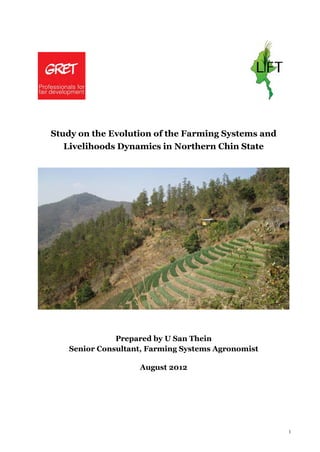
- 1. 1 Study on the Evolution of the Farming Systems and Livelihoods Dynamics in Northern Chin State Prepared by U San Thein Senior Consultant, Farming Systems Agronomist August 2012
- 2. 2 Table of Contents I. INTRODUCTION ......................................................................................... 4 1. Objectives of the Study............................................................................... 4 2. Expected Mission Outcomes.......................................................................... 5 3. Methodology ............................................................................................ 5 II. Presentation of the survey cases...................................................................10 1. Location and Geography.............................................................................10 2. Settlement Pattern ...................................................................................12 3. Upland Ecology, Households, Land and Land Tenure Bounded by Tribal Community Culture..................................................................................................15 4. Location of Village in Relation to Forests, Taun-yar (Lopils) and Paddy Land..............15 5. Farming Systems of the Study Areas...............................................................17 6. Past and Present Situation of Taun-yar or Shifting Cultivation ...............................18 III. Evolution of farming systems & Livelihood Dynamics...........................................27 1. Good Practices and Weaknesses in Taun-yar Farming ..........................................27 2. Changing Process of Lowland Paddy Growing and Terrace Farming..........................30 3. Process and Pattern of Terraced Farm Development...........................................33 4. Legal Aspects and Land Registration in Permanent Farming Plots ...........................41 5. Land Use Types in Relation to Wealth Classes in Sample Villages ............................45 IV. Food Security Attained by Different Livelihood Activities .....................................50 1. Sources of staple food ...............................................................................50 2. Change in Dietary Habit over 20 Year- Period ...................................................59 3. Demand and Supply Situation of Rice in Northern Chin State .................................63 V. Examination of the Population Dynamics and Land Cover changes ..........................66 1. Population status and evolution....................................................................66 2. Migration Dynamics...................................................................................68 3. Assessing the Carrying Capacity of the Land Resources ........................................70 4. Land Cover Changes ..................................................................................74 VI. Activities and Programmes of the Developement Agencies and Local Initiatives for Livelihood Improvement and NRM in Northern Chin State .....................................76 1. Development Agencies...............................................................................76 2. The Government and Non-Government Activities for Crops Development..................77 VII. Recommendations and Conclusions................................................................78 VIII. ACKNOWLEDGEMENT .................................................................................81 IX. REFERENCES ...........................................................................................82 X. APPENDIX...............................................................................................83
- 3. 3 SUMMARY Chin State has been often characterized among all States and Regions of Myanmar as the highest poverty gap ratio, highest occurrence of food deficits, poor road connectivity on steep mountain ridge and narrow valleys, low population density but lowest percent availability of cultivable lands and high percentage of waste and scrub lands, adherence to the shifting cultivation system, lack of rural based industries, and higher rate of out migration. Group of Research and Exchange of Technologies (GRET), French-based INGO has been for more than 17 years implementing the livelihood programmes and natural resources management (NRM) scheme in Northern Chin State. This study has been conducted in four towships of the northern Chin State in 2012 to assess the evolutionary process of farming systems, the changing livelihood strategies, changing agents and to recommend future actions. Field trips to 12 sample villages in four towships, focus group discussion, case studies, desk review, and collection of secondary data and application of GIS-RS were performed to meet the expcted outputs. Shifting cultivation system is major livelihood of majority of poor farmers. Maize –based subsistence farming had been and is still changing towards rice-based semi-commercial farming system. Terracing has been developed since 1960s but the changing process was slow. Only better–off farmers attempted terracing. There is prevailing equity in assigning taun-yar (shifting cultivation plot) lands to villagers. There is mixture of communal land and private herditary lands in taun-yar land use but the low- land paddy fields and terraced fields are private-owned. In the last 20 years, maize was staple food supplemented with sulphur bean, millet, beans and vegetable. Rice was luxuary food and dietary change to rice as staple food occurred in associastion with development of low-land paddy fields in the mid-1960s and changing process become rapid after 1970s. Evolution of terraced fields was slow until 1990s. The present decade (2001-2010) marks the mass adoption of terracing practices due to the assistance of the UN agencies and international and national NGOs. Due to increased population taun-yar cultivation had shortened the fallow period accompanied with yield decline. It was found that taun-yar cultivation provides maize from 3 to 6 months only in a year to farmers who rely on other income sources for the food need of the remaing months. Low land paddy cultivation provides staple rice for the family need of 5 to 7 months in a year. Livelihood combination is necessary to meet the year round requirement of food. The assistance of GRET as changing agent are guidance in site selection, hands-on training on terracing, tapping water resources, methods of soil conservation or mulching with crop residues on bare soil, injection of food for work or cash for work, all these packages have good impact on the livelihood of the beneficiaries as well as natural resources conservation. For future gain in economic viability in farming, improved fruit trees culture, integrated resource management with local governance, access roads and markets, agro-forestry practices are issues of concerns.
- 4. 4 I. INTRODUCTION Group of Research and Exchange of Technologies (GRET), French-based INGO has been for more than 17 years implementing the livelihood programmes and natural resources management (NRM) scheme in Northern Chin State, Myanmar and has been acknowledged for its experience and rich knowledge of the project’s area. It aims at improving the livelihoods of the vulnerable households by promoting sustainable livelihood and NRM schemes as well as building the capacities of local actors and communities in order to ensure the sustainability and appropriateness of any actions. The Northern Chin farming systems are based on shifting cultivation systems with a marked reduction of the fallow period (from 15 ears to 6-9 years) in the last decades. The overuse of land and overexploitation of natural resources have led to high rate of deforestation and severe environmental degradation and climatic changes. As a direct consequence, the food production has considerably decreased and households suffered a food gap varying from 4 to 8 months. The steepness of the slope and narrow valley of the common phenomena of the Chin mountain land systems have also led to high land development costs, lack of access to agricultural inputs and few provisions of technical services and moreover difficult communication weakens the marketing channels. Due to lack of job opportunities, migration in both temporary and permanent increased to ensure that the remaining family members could be supported by remittance. Meanwhile there are local initiatives by individuals and communities to evolve more permanent and sustainable farming systems and contribute on a long term basis to the poverty alleviation and food security through agricultural intensification and diversification, increase of productive resources and improved management of the natural resources. Local communities, public services and development organizations have been highly engaged in building the resilience of the Chin population towards adverse events and climatic changes to reduce the venerability of the families towards the uncertainties of food production and irregularity of incomes. 1. Objectives of the Study Accordingly, a field survey and comprehensive study on the evolution of the farming systems and livelihood dynamics in the Northern Chin State has been conducted in the months of January to February, 2012 with support from GRET Chin project office, Yangon and Hakkha. The main purposes of this study are to provide: i. A comprehensive analysis of the evolution of the farming systems and livelihood of the Chin villagers ii. A good picture of the initiatives in places in order to better tailor the humanitarian and development interventions to the local situations and existing needs and opportunities. Based on the output of the analysis, GRET will organize workshops with different stakeholders to present the findings and learning and discuss future livelihood strategies and potential alternatives to be developed by development actors.
- 5. 5 2. Expected Mission Outcomes The finalized report is required to deal with in detail: iii. An overview of the main agrarian and livelihood changes occurred in the last decades. iv. A characterization of different agrarian and livelihood systems currently developed in the Northern Chin State. When analyzing the different farming systems, the consultant will take into consideration the agro-eco-systems, socio-economic factors, and tenure and impact of those systems on the environment and management of natural resources. Diversity of the agro-ecological and socio-economic situations of the four study townships will also be observed. v. Information on the financial strategies of the households will also be provided. vi. Identification of the constraints and opportunities to further improve and develop more sustainable farming systems and livelihood activities. vii. Presentation of the individual and collective strategies developed by Chin communities for coping with changes 3. Methodology a) Selection of Survey Areas The study mission has been undertaken in Hakkha, Falam, Thantlang and Tedim townships. Three GRET-assisted project villages in each township have been selected for study presumably representing diverse agro-ecological and socio-economic situations and different livelihood activities of the whole project areas. Table 1 Selected project villages for survey in four townships of Northern Chin State Township Village 1 Village 2 Village 3 Hakha Zathal (Sakta) * Tiphul (Tiphul) Tinam (Tinam) Falam Ramthlo (Ramthlo) Thanhniar (Laizo) Phaizawl (Phaizawl) Thantlang Congthia (Congthia) Farrawn (Vanzang) Sihmuh (Thangzang) Tedim Ngennung (Vulvum) Laibung (Laibung) Suangzang (Suangzang) * Name in parenthesis is village tract name. The GRET assisted projects have been operated since 1995 in four townships of the Chin State, viz; Hakha, Falam, Thantlang and Tedim. The coverage of villages under GRET project represents 24.1 % of total villages of the four townships. GRET covered initially 56 villages and has now extended to 105 villages in the latest project phase. Survey programme of this study has covered 12 villages in four townships as stated below. Survey schedules were prepared and implemented as stated in Appendix Table 1. Four survey team members of GRET (residence local staff of Hakkha, Falam, Matupi and Tedim respectively) assisted the survey programme in translating the local dialect and compiling the data and information. The survey team members are listed in Appendix Table 2.
- 6. 6 b) Focus Group Discussion (FGD) Semi-structured and open- ended questionnaires were prepared in consultation with the Chin GRET project manager. Local knowledge of the junior Chin researchers was also taken noted during the preparation stage. Major points included in the survey questionnaire are dealing with the past and present situations of household diet and consumptions, their livelihood activities, farming systems, food costs, changes in dietary habits, old and current practices of taun-yar (shifting cultivation), dynamics of fallow and cultivation circles of taun –yar system, change in staple foods consumption with respect to wealth classes of the communities, their access to land resources and off-farm activities, changing pattern of the unstable shifting cultivation to permanent farming and terracing, local initiatives and intervention of the government and development organizations in natural resources management, changes in ecology, migration pattern, population pressure and carrying capacity of the land resources, transport routes and market channels of foods directed to the Chi State, gender issues, costs of cultivation and comparative advantages of farm commodities and assessment of their long – term survival, coping strategies of the local communities to alleviate food shortage, etc. During the FGD, age-old peoples were first invited to discuss the last 10 to 20 years situations of the local environment, settlement pattern, and farming systems dynamics, which were comparatively asked together with the present situations. The perception of both old and young peoples was also recorded. c) Individual Data Input and Community Profile At least one-third portion of all households in each village were invited to gather the information on the access to different types of lands, crop outputs, number of months that could be fed to the household with such outputs, his off-farm activities to supplement the food need, number of migrant workers in a family, etc. List of individual households owning number and types of lands according to the wealth class of the village was compiled with the help of the Village Administration Council and GRET community leaders in the respective village. Structured information was gathered for getting community profile d) Transact Walks and Record of Ground Truth Visit to the households and village structure was recorded and if necessary digital photo record and geographic positioning systems (GPS) readings were taken. Field visits were made to rapidly assess the farming and livelihood activities. Natural vegetation, land forms and infrastructural development were observed inside and outside the village. e) Determination of the Equity in Access to Lands Access to agricultural lands, size and type, was compiled in terms of class intervals and frequencies and Lorenz Curves were constructed according to the standard method. By comparison, similar data set was obtained during the previous survey in GRET –assisted villages in Monywa Township. Distribution of land ownership was compared in Chin village and plain land village of Upper Myanmar by means of Lorenz Curves and Gini-Coefficients.
- 7. 7 f) Assessment of Population Pressure Population intensity is customarily expressed in terms of population density, i.e. population per sq. mile or population per sq. km. Such density figures are not indicative of real population pressure on natural resources. A better measure on rural areas can be found from the optimum population Index as modified from Misra et al. (1979). Index of population pressure (I) = (P1) / A Where: I = index of population pressure per sq.km of the rural area P1 = Region–wise derived rural population capable of being supported by the utilized land resources by assuming a constant income per person. A = Total area of the rural region at a particular point in time. P = Actual rural population at a particular point in time. P / A = Actual population density of rural area per sq. km. In attempt to assess the carrying capacity of the Chin project areas, population census data were compiled from various departments with some difficulties. The contact government departments are Department of Immigration, Department of General Administration and Chin State library sources, altogether with the former British Administration documents, Chin intellectuals and Catholic and Baptist missionary old records. It was expected that the old and current records of population will tell us if there is real population pressure in the past and in the current times affecting the livelihoods in terms of carrying capacities of the existing natural resources, the productivity and output values. g) Land Use Factor In our next attempts to evaluate the farming systems dynamic moving from the shifting cultivation to semi- permanent and permanent farming systems, the land use factor as expressed by “R” value (Ruthenberg, 1976), referring to my old lecture note during the schooling days at the University of Florida, U.S. R = percentage of land involved in the rotation that is being cropped in any one or more years. R % = [ C / (C + F) ] X 100 Where C = years in cultivation F = years in fallow period R value will be applied to avoid the arbitrary boundary between shifting cultivation and semi- permanent rain –fed farming. R indicates relationship between crop cultivation and fallow period within the total length of one cycle of land cultivation. Shifting cultivation system has generally expressed the R value of 10. The larger the R value, the more stationary character of the farming system. If R exceeds 30, we can hardly speak of it as shifting cultivation. It could be regards as semi-permanent farming. If R value exceeds 70 %, permanent farming is said to be practiced. An R value of 150 would indicate 50 % of the area is carrying two crops a year.
- 8. 8 h) Land Cover/Use Map of Northern Chin State Chin Hills have often been characterized by shifting cultivation, deforestation and loss of land covers. Some talked about this issue at the rural village tract level, some at urban level and some at the whole state level. In this study programme, the respective satellite images were downloaded covering the ground truth data taken at the visiting project rural sites (village tract level). Moreover assessment has been made over the whole Chin State. Land covers changes are numerically recorded for all village tracts area in the northern Chin State. An overview of land cover/use classification of the project area using remotely sensed data was briefly documented as follows. To produce a land cover/use map, there were many decisions, choices, and compromises regarding image selection and analysis methods depend on the study area and available resources. Although the terms "land cover" and "land use" are sometimes used interchangeably, they are actually different. Simply, land cover is what covers the surface of the earth and land use describes how the land is used. Fore conservation priority purpose, the output classified map includes a mix of land cover and land use (commonly use “land cover” map). The important thing is that each class on the map be clearly defined and distinct from other classes. i) Satellite Data When selecting satellite data, the main objective was to have a basic coverage of satellite data for the entire project area with every part of the area covered by cloud free data. According to the project need, medium resolution satellite data was considered the most suitable satellite type for producing the land cover database, taking into account the cost and time limits for the production of the database. After initial studies, it was decided to use the Landsat ETM+ data and IRS data acquired in dry seasons of 1990, 2000 and 2010. Reference Data Different types of reference dataset were used in the classification process. The main reference dataset were country-wise data such as 1:50,000 scaled topographic map, very high resolution Google Earth data, and ground truth data collected from field survey march 2012. Land Cover Classes The basic principle when defining the Land cover class was to make the dataset to “Level-1” classification, using the legend and class descriptions of the existing land cover data produced by the Forest Department. Whenever necessary, the Level-1 classes may be further divided into two or more subclasses depend on the field observations and applications. The classes listed below are the land cover and land use classes for the project area; 1. Closed forest (canopy > 40 %, vegetation height > 3 m) 2. Open Forest (canopy < 40 %, vegetation height < 3 m) 3. Scrub/Bush/Grass Land 4. Agriculture (Le/Yar – Terrace) slope < 30 % was assumed as paddy land 5. Agriculture-Taun-yar 6. Water Body
- 9. 9 Figure 1 Flowchart of Land cover Change process Classification Methodology Before deciding upon what classification methodology to use, several criteria have been considered: Obtaining a product of high quality Create a methodology that is repeatable (for updating purposes using field data) Time and cost efficiency in the production work These criteria indicates the need for an automated procedure, class labeling each pixel by integrating different types of geographical datasets and satellite data based upon their characteristics with logical, predefined rules. In order for an automated classification algorithm to associate pixel values with the correct land cover category, the inputs from the reference data were used. This procedure was referred to as supervised classification. There are several types of statistics-based supervised classification algorithms. With Maximum Likelihood classification algorithms the analyst first located and defined samples called training areas in the image of each class that are required for the final map by using the inputs from reference data. IRS (2010)Landsat 7ETM+ (2000)Landsat 7ETM+ (1990) 1:50,000 Topographic Map Rectify Images (1990,2000,2010) Preprocessing Feature Extraction/ Selecting Training Data Ground Truth Data Supervised Image Classification Land cover 1990 Land cover 2000 Land cover 2010 Change Detection Maps Images Overlay Process
- 10. 10 In order to achieve the best quality - within the limitations set by the spatial and spectral resolution of the satellite data, the nature of the reference data and the time and cost limits for the project - the final Land cover product obtained different input data from diverse sources as possible. This means that the final product not simply is based on only the results from the classification of the satellite data, but also from integrating land cover information from reference data and key informants. Hence, the final product can’t simply been seen as a classification, but more as a GIS generated product. Some classes were handled separately by manual editing with update inputs whenever possible and then combined in the final steps of the classification process. Accuracy and Validation All land cover maps are commonly made without visiting each site except for not more than 20 sites. For a specific purpose on the GIS guided monitoring, field visits to the study area need to be definitely made. Main reason for field visit is to collect data that can be used to evaluate the land cover map and estimate the accuracy of the individual classes (a process called validation). Data collected in the field must be geo-referenced by using GPS device so that the point where the data were collected can be located on the imagery. Application This classified data can be used for a host of any quantitative analysis applications such as conservation priority. They can also be used as visual aids in a presentation or as a layer in a Geographic Information System (GIS). It is important to keep in mind that a classified map is only an approximate representation of the features on the ground. The accuracy of this representation can greatly affect the results of any quantitative analysis. II. Presentation of the survey cases 1. Location and Geography The Chin State, in North Western hilly part of Myanmar, lies between latitude 240 on the north and latitude 24o 45´ on the south and between longitude 94o 5´ on the east and 93o 20´on the west (Map 1). The hill tracts form a parallelogram and is stretching from north to south in 402 km (250 miles) while its breadth varies from 161 km to 241 km (100 to 150 miles), covering an area of 35,992 square kilometers (13,902 sq. miles). Mountain topography is a very irregular and rugged surface forming continuous ridge with interconnected hills of steep slope. The ridges are separated by narrow valleys, forming into saw tooth outline. Underhill mini plains are narrow and isolated. On Chin hill tops, there is rare to see extensive plateau as in the hilly areas of Shan State. The main ranges vary in height from 1,524 m (5000 ft.) to 2,743 m (9,000 ft.) above sea level. In the north the most striking peak is Kul (called Kennedy Peak) with 2,700 m (8,860 ft.). The largest river is Manipur. The bed of the Manipur River below Falam is about 396.3 m (1300 ft.). In the times of British colonial administration, Chin Hills are constituted as Scheduled District under the Notification in 1886 and after Myanmar gained independence it was designated in 1961 as Chin Special Division and it was reorganized as Chin State in 1973 under the constitution of the Socialist Republic of the Union of Burma. Under the present parliamentary government, the Chin State government body has been formed to directly operate the state level administrative and development affairs.
- 11. 11 Despite the fact that the Tropic of Cancer crosses near the township of Hakkha, capital city of the State, it is hard to say that Chin Hills are characterized by tropical climate. The climate, judged at an elevation of 2,500 to 6,500 ft., is considered to be sub-tropic. Total annual normal rainfall recorded at Hakha is 1850 mm (73 inches) Figure 2. Total annual rainfall at Thantlang is recorded to be about 2032 mm (80 inches) (Appendix Table 3). The coldest period in Hakha extends from December to February with minimum temperature going down to – 40 C. The warmer months are May to September with the maximum temperature of about 250 C with small diurnal range. The night temperature during the summer and monsoon period is moving around 100 C to 120 C. (Figure 2) Frost usually occurred in the months of December and January at Falam, Hakkha, Tedim and Mindat and around January at Thantlang and Tonzang. Climate and weather vary also with respect to topography and elevation. At bottom valley at Larva stream near Thantlang, kapok trees (silk–cotton trees) are found growing in bunches indicating a habitat of tropical climate in that pocket area (please see photo section Figure 53). 0.00 50.00 100.00 150.00 200.00 250.00 300.00 350.00 400.00 Jan Feb Mar April May Jun July Aug Sep Oct Nov Dec Precipitation(MM) -10 -5 0 5 10 15 20 25 30 35 TemperatureinCentigrade Average Precipitation Maximum Temperature Minimum Temperature Figure 2 Monthly rainfall and maximum and minimum temperature, Hakkha, 2011 The mountain land system is primary determinant in varied situation of weather, climate, tribal settlement pattern and their livelihood. Figure 3 shows the general features of the mountain land system. One could see a Chin Hill village or any settlement areas by taking into the features of this mountain system and it will help characterize the area concerned. In later chapters, brief description of mountain land system will be given wherever relevant with the aid of the GIS images.
- 12. 12 Mountain System Ridge/Summit Mountain side Bottom land - Concave Terrace slope Drain type surface - Convex - Concave slope - Parallel - Narrow inter-hill surface - Convex slope - Dendrite Mini-plain - Straight slope - Board inter-hill - Convex contour mini –plain - Concave contour - Colluvial fan - Terrace withtable top like surface - Interfluve - Ridge crest - Oxbow lake - Terraced slope - V –shaped valley - Degree of slope - U –shaped valley Figure 3 General features of mountain land system 2. Settlement Pattern Sources of Chin settlement history are varied as oral, stone inscriptions, literature and archives. As oral sources, folklore, folksongs, hymns, and rituals had been interpreted for the early settlement of Chin in the absences of historical evidences. According to Professor Luce (1959), the Chin of the Tibeto-Burma Group, descended from western China and eastern Tibet into the south via the Hukong valley. Chin in the Chin Hill, Myanmar and Lushai in Lushai Hill, Mizo (Indian side) belong to the same group collectively known as Kukis. Evidences have been often quoted that the Chin of Myanmar first settled in Chindwin valley. Professor Luce suggested that the Chin settlement in the Chindwin valley began in the middle of the eighth century referring to the Pagan inscriptions1. In thirteen century, Shan gained rising power in Upper Chindwin and Central Burma, and the Chins were pushed up to the hills. A vast majority of the Chin people moved over to hill regions of the present Chin State in Myanmar and Manipur State in India and the Chittagaung hill tracts in Bangladesh (L.H. Sakhong, 2009). In Myanmar Chin hills, the moving Chin split into different tribal groups speaking different dialects, with different tribal names. F.K. Lehman (1963) depicted that Chin in the north settled on the ridges and other in the southern Matupi Subdivisions, settle near river banks while some Kanpelet villages extend from a stream bed up a very steep slope onto a defensible spur. 1 G.H.Luce, 1959. Chin Hills- Linguistic Tour (Dec. 1954), University project, Rangoon University
- 13. 13 Figure 4 Typical location of Chin village In the study area, Chin settlement pattern could be observed that the villages were established with orientation to secured and defensible position, access to farming and water sources. In the typical settlement diagram, villages are on the mountain spur with a good view to all cardinal points. Way above the village, there usually is mountain peak clothed with forest and source of mountain spring. Shifting cultivation (taun-yar) fields (Lopil2) are locating around the surrounding mountains and hills ranging from 3000 ft to 6000 ft. Going down to valley bottom of 3000 ft. to 1000 ft., there usually occurred malaria- infested stream and the tribal people in old days did not customarily lay out paddy fields or cultivate near stream banks (Figure 4). Lowland paddy cultivation was not their livelihood activity until the last 50 to 70 years ago3. Valley bottoms are also too narrow to allow the village settlement. Moreover, village, if it is located at the valley bottom would be far away to their Lopil fields to carry up and down of their farm outputs. Thus the Chin villages are generally up on hills. Malaria-borne mosquito (Anopheles mosquito) could not fly 3000 ft above sea level. However, 3000 ft. may no longer be the definite limit of safety due to the encroachment of global warming effect in present days. In Myanmar, it has been often said that settlement pattern varies with respect to habitat of ethnic groups. The following upland ecosystems have been associated with settlement pattern of different ethnic groups. 2 Lopil : The term “lopil” is used in Hakkha, Falam, Tedim and Thantlang meaning shifting cultivation field rotated from one location to another within the boundary of their traditional land use right. The smaller divisions are called by the Chins as “lo” and will be referred to as “plots”. 3 Based on the documented reports on The Chin Hills by Carey, B.S. and H.N. Tuck (1987) Govt. Press, Rangoon pp. 212. and my survey findings (January –March, 2012)
- 14. 14 Table 2 Upland Agro-ecological Systems in Association with Settlement Pattern of Ethnic Groups of Myanmar (common observation) Elevation (Indicative approximation) Crops commonly grown Common settlers 6000 ft. Apple / pear Chin / Kachin 5000 – 6000 ft., steep slope Maize, millet, buckwheat, avocado Chin / Kachin 3000 – 5000 ft., steep slope Tea, walnut, wheat, avocado, potato, maize, millet Palaung * Moderately high, < 3000 ft. Paddy, maize, coffee, taro Karen* */ Shan Valley bottom, near stream bank Lowland paddy, sesame, maize, pulses Shan / Danu *** * Palaung also do not usually take risk of mosquito. In day times they go down the bottom valley and work there and before dark they hurriedly go up the hill. ** Karen may adopt combination of permanent wet –rice mono-culture on bottom land and shifting cultivation for upland rice on adjacent forested hill sides. *** Shan /Danu may probably possess indigenous medicine or herbs to keep cure of the malaria. In the flat plain area of Myanmar, villages were originated near the rivers and the settlement pattern of the communities was clustered around the rivers. Later the settlement expanded not only along the rivers but also along the road transportation networks. In the settlement pattern of upland villages of Chin Hills, on the other hand, access to the transportation network was not the major factor and it was particularly true in the old days under the subsistence economy system. The defensible position, suitability of upland terrain and topographical surface unoccupied by any community may be the first selection criteria for settlement site of the tribes of pre-annexed times. The author tempts to validate this assumption when he suddenly saw the terrain of Sihmuh, a remote village of Thantlang township after his team crossed three or four mountains with risk, fatigue and difficulties. The terrain near the village assumed a gentle slope, large and smooth surface upon which several plots in lopil are seen. The old village site was not seen due to relocation (Figures 98, 101 and 103 of Photos). Villagers said that it was established in 1880. For earlier settled villages, the located site will be in better position in terms of capacity for defence, proximity to running water and fields, presence of shelter from wind and accessibility. In the case of very old village such as Ramthlo, Falam, topographical surface of its lopil is relatively smooth and slope is gentle. In present days, the motor road from Falam to Hakha is passing by the village (Figures 88 and 76 of Photo section).
- 15. 15 3. Upland Ecology, Households, Land and Land Tenure Bounded by Tribal Community Culture In Chin society, land was a spatial term which symbolized identity, culture, traditions and spiritual value (Vanlalbruaia, 2009). To them there are two types of lands – village or settled area and general country side or home land. Both types include not only the village, fields, forest and water resources but also had spiritual implications. Maintaining a balance between people, their village and spiritual realm was required for the stability of their community. Figure 5 Hypothetical diagram showing land–man relationship was imbedded within ecosystem and tribal community culture According to their customary land tenure, it was generally assumed that all land belonged to the community chief. If he claimed that “This is my land or my territory”, this does not mean that land was the sole property of the chief. He may be the keeper of their land rather than the sole landlord. The community under the stewardship of the chief had the right to use or share the natural resources which signified the mutual respect and interaction between the spirits, nature and people. This traditional concept of land gave birth to community ownership of land. Such community tradition and culture attempted to harmonize with the ecosystems of their land and bind together the households, land and shifting cultivation field (lopil) (Figure 5). It will be examined in later Chapters how and why these processes and patterns have been changed with passing time. 4. Location of Village in Relation to Forests, Taun-yar (Lopils) and Paddy Land Chin villages are normally located on the mountain spur. There is a quadrant or circular belt of forest about half a mile away from the periphery of the village, keeping it a safe distance from the possible spreading forest fire. This forest belt is also generally protected allowing no villager to collect fuel or timber wood. Similar practice may be applied to the forest near the source of mountain spring on top of the mountain. If the outer circle is under the community forest, this zone is allowed for collection of fuel wood and timber. Taunyar (lopils) fields are lying in the periphery area of the community resources boundary (Figure 6). It will take one and half to two hours per foot-path trip from home to taunyar plots.
- 16. 16 Figure 6 Schematic diagram showing village location in relation to forest and lopils The lopils (shifting cultivation fields) are the integral part of the village settlement and walking distance between the two usually takes one to two hours or about 7 miles within. Over a period of half century, behaviour changes and livelihood diversification have led to the establishment of lowland paddy fields and orchard grooves. A particular case could be seen in Farrawn village, Thantlang Township (Figure 7). Figure 7 Walking distances between the village and the types of land (Sketch of Farrawn village, Thantlang Township)
- 17. 17 For a better understanding of the Chin settlement pattern, digital photo records and GPS – guided satellite images over the study villages have been taken. The satellite map of the Ground Truth data (Point 2), taken over Zathal village, Hakha Township, the village location could be clearly seen with nearby pine forest hill. The opposite side to the village and forest, there lies a large mountain range with moderate slopping on which several patches of taun-yar (lopils) plots could be noticed. Lopils and the village are not as close as that to the forest. Paddy fields are lying by the side of Boinu River running beyond the pine forest. It could be seen in the Ground Truth Point 3 satellite image. There is a broad inter-hill mini-plain. Zathal and the nearby village, on either side of the stream had customary access to the paddy lands in such a way that the village could work on the paddy fields occurring on the respective village side of the stream. The stream course in the inter-hills sometimes is running in semi-circle way leaving a wide flood plain beside the stream bank for the villagers on the corresponding side. If the next semi-circle turn of the stream leaves another flood plain beyond the corner of the inter-hills, this portion will be entitled to the opposite village of the former one. The digital photo record of Figure 79 could be matched with satellite map of Ground Truth Point 3. The river side is the natural boundary of the two villages for land access. Figure 54 of Photo section and the satellite map of Ground Truth Point 20 have shown how the Chin villages (here Ngennung village for example) were established on the hill. Table–top like flat places are rare in the Chin Hills and the villages are typically established on the slope of the mountain spur with each house laid on the contour ridge. The house front side rests on the near surface ground, probably beside the village road side, while the hind legs of the house go down the deep slope and the legs (timber post) must be long enough to touch the ground. If the perspective view of the whole village could be taken with a good camera, one can see that village houses are laid out in contour lines. Growth and expansion of the villages and urbanization also point out bare hill tops and deforested slopes. Example is given as landscape near Hakha town (satellite map of Ground Truth Point 4). One can see easily and clearly such landscape from Hakha without the aid of the satellite map. But here attempt was made to keep record of the eye witness by supplementing with satellite map record. By comparison, the photograph record taken by Carry and Tuck (Volume I, Figure 17) (1932) could be seen for the situation of Falam landscape. At that time Falam was a big village and there was a thin vegetative cover in the surrounding area even on that time. 5. Farming Systems of the Study Areas Chin villages of the study area could be characterized by mainly subsistence economy with low degree of commercialization. In old days, food crops grown are largely divided into four classes, grain, pulses, roots and vegetables. Grain comprises millet, Job’s tears, maize, rice and jowari. Pulses include gram, peas, small bean, dhal (pigeon pea), aunglauk bean (sulphur bean or jack bean (Canavalia ensiformis). Root crops include sweet potato, yams, turmeric and ginger. Vegetables include pumpkins, cucumber, onions, chilies, egg plant and wild varieties of spinach (Carey and Tuck, 1895). Northern Chin farming was done on steep, high altitude and cool monsoon forest area. The staple crop was not rice but maize although varieties of millet and hill rice were also grown. Bottle gourds, cucumber, onion, garlic and tobacco were grown in home gardens while cucumber was also grown in taun-yar fields (Lehman, 1963). Farming was largely diversified producing a large number of food crops to meet varied diet in the northern Chin.
- 18. 18 Under the farming systems of the Northern Chin, all aspects of taun-yar or shifting cultivation, permanent paddy cultivation or orchard, home gardening, livestock raising, consumption and dietary habit, natural vegetation and resources management, land tenure, population changes and migration and market access will be thoroughly discussed. Faming systems profiles of three study villages from each of four townships are shown in Table 3a, 3b, 3c, and 3d. In each land use system, attention will be paid to the dynamics of changing process in response to the external agents. 6. Past and Present Situation of Taun-yar or Shifting Cultivation The Northern Chin will be assessed in terms of the years of consecutive cultivation and fallow, elevation and settlement pattern, main crops, complementary crops, vegetation types, tillage or land preparation system, resources management practices, effects on vegetation pattern, effects on the soil fertility, market integration, indigenous knowledge, land tenure and equity issues. Table 3 (a) summarizes the overview of the past and present farming systems in three sample villages of Hakkha township. Zathal was a relocated village due to the shortage of taun-yar lands (lopils) in their original Buanlung village. With the consent of the chief (landowner) of the Sakta village, Zathal villagers were allowed to open up their lopils adjacent to Sakta villagers’ lopils. The village location and taun-yar lopils could be seen in the satellite image of GPS Ground Truth Point 2. Beyond the pine forested hill, Boinu River is running and beside it is mini plain land. It was bought from Sakta village chief and converted into bench–terraced paddy fields by Zathal villagers. The view could be clearly seen in Digital Photo 79 of Photo section, GPS ground truth Point 3. Initially there were 19 hamlets and over 15 years, their relatives and friends from the former villages came and join the new site. By 1960, the village grew to 30 houses and the number reached 82 in 2012. Tinam village had been relocated two times. Former village site was at relatively lower position than that of the lopil plots and taun-yar fire spread to the villages in noon time and water was scarce and the whole village was burnt down. The government township administrative officers relocated them beside the road side on the way to Gangaw. Originally they have 7 lopils but one lopil was used for village location. Tiphul was the old village remained in the original site but over-grown households moved to new site, keeping both villages very close and sought the new taun-yar area. All cases of three villages indicate that access to cultivated lands is the major driver to the movement, relocation, expansion or split of the villages and their settlement pattern. Land – man ratios (acre/head) are less than unity (0.21, 0.36, and 0.66). It will continue to adversely affect the future stability. Paddy land area is few in Zathal and Tinam while the relatively large village of Tiphul has about 120 acres. Land use factor (R value) in taun-yar cultivation varies from 7.7 % to 16.7 % and the largest value reaches to 23.5 %. The larger the R value, the more stationary character of the farming system. If R exceeds 30, we can hardly speak of it as shifting cultivation. In the three villages, fallow period is still relatively longer in relation to cultivation period on the lopils. However, the fallow years become shorter now as compared to the previous 20 years in all three villages. If the fallow period becomes shorter than 10-year–cycle, forest regeneration could not have been sufficiently taken place. Number of households working on lopils increased in Zathal and Tinam while it decreased in Tiphul because the latter village expanded paddy fields. Sizes of taun-yar field available to individual household are reduced in all villages due to increased households. Crop productivity in taun-yar expressed in maize yield per acre was varying from 375 kg to 625 kg in the last 20 years and it decreased to 234 kg to 500 kg at present.
- 19. 19 Maize is major crop in taun-yar while paddy is pillar crop in mini-plain area or terraced irrigated fields all villages. Sulphur bean or sword bean is complementary to maize crop in taun-yar. In taun-yar cultivation, there are two types of land tenure: communal and private owned. Zathal village practiced communal land tenure with no ownership. The village chief with the assistance of the village committee allocates land to all households. About three family members (Village chief and his committee members) and those who have no terrace fields are considered to have priority in selecting fields to their preference in the lopil and the remaining fields are then equally assigned to all remaining households. Table 3 a. Profiles of farming systems (past & present) in Hakkha township Zathal Tinam Tiphul Sr. Variables 20 years 2012 20 years 2012 20 years 2012 backward backward backward 1 Village Tract Sakta Tinam Tiphul 2 Year established 1946 Relocated in 1954 assumed to originate 400 yrs ago 3 No. of households (HHS) 40 82 112 105 150 142 4 Population 200 447 668 587 NA 620 5 Total cropped area (acre) - NA 296.09 214 NA 130.35 6 Land-man ratio (acre/head) 0.66 0.36 0.21 7 Paddy acre 70 86.09 NA 49.25 70 121.35 8 Terrace acre NA 44.85 9 Orchard acre 10 Shifting cultivation acre 210 119.9 100 11 Fallow period (years), 60 20 12 8 20 10 12 Cropping years, No.8 10 6 1 1 3 2 13 No. of Lopils 6 5 6 6 5 5 14 No. of HHs in shifting plots 40 82 50 70 150 HHs 120 HHs 15 Size of alloted plots in Lopil 3 acres 1 acre 3 acres 2.5 -3 acres 3 acres 2 acres 16 Crop productivity ( yield) 375 kg maize/ acre 234 kg maize /acre 500 to 625 kg per acre maize 400 to 500 kg per acre 500 kg per acre 312 kg per acre maize 17 Land use factor (R)* 14% 23% 7.69% 11.11% 13.04% 16.67% 18 Crops grown Maize, paddy, bean, sulphur bean paddy, maize, vegetables maize, millet, sulphur bean paddy, millet, maize, vegetables maize, millet, sulphur bean paddy, maize 19 Management system for taun-yar (land assignmant or land entitled) Village chief allocated lopil plots VPDC Chairman and village committee allocate land to applicants; Nobody is allowed to rent the land unless he could cultivate; Only village chief assigned lands; landless draw lots. VCPD Chairman assign plots; Village elders assist; landless draw lots except 20 HHs with hereditary title for ancestral land.. Village chief assigned lands to all except hereditary title holders 3 Lopils are ancestral lands; 2 lopils are assigned by village chief to applicants by drawing lots; 20 Migration Malay = 70; US = 17; Ausi = 10; Norway = 4 Malay= 50; US =50; Ausi = 20; Canada= 3; Mizo = 10 Permanent migration - Kalay = 45 HH; Hakha = 70 HH; 317 migrant workers to Malay 21 Elevation, ft (estimate) 6152 ft. 4520 ft. 5183 ft. * R = [ (C/C+F) ] x 100 = %; Where C = years in cultivation; F = years in fallow period
- 20. 20 In Zathal, every family could get land in lopil. A family could not rent his land if they could not cultivate. If they could not cultivate they surrender it to the village chief and the village authorities would assign back to applicant for taun-yar lands. There is ownership in paddy land. One can develop it or could buy from another landowner. If one wishes to develop a terrace field in village communal pasture lands, he could apply for it to the village chief with the term of condition that he will make a fence around his field and it is his own responsibility to keep away the animals from his plot. In Tinam village, some parts of lopils are ancestral land occupied by 20 households. Except that land, the rest parts of lopils are communal land upon which the village chief assigned land to the villagers by letting them drawing lots. The same practice continued until today. The village elder and committee assist the Village Chairman in assigning lands to the landless households. Over 20 years, the number of households increased by annually 2 % with demand for taun-yar plots. When the village’s lopil number decreased from 7 to 6, they have to expand the boundary of the lopil to be able to allot lands to everybody. With increase in household number over time, lopil boundaries will be accordingly expanded encompassing the marginal land on the mountain and all the lopil boundaries will come into contact with each other reaching a final limit. In expansion, lopil number will diminish from 6 to 5, from 5 to 4, etc. Fallow period will become shorter. Although not all the plots in lopils are communal lands, the arrangement of taun-yar cultivation is collective at the village level. Every year in Tinam, assignment of lands to households take place usually in August – September. This is a village level meeting. After assignment of lands has been over, each individual household starts cutting and felling trees and plants in the respective assigned plots during the period from October to December. There may be pool of labour in cutting trees. In the past 20 years it took minimum 60 days to finish this task but now could complete it within 45 days. In the past farmers used axe but now knife or hoe is good enough. In Zathal, no large trees are grown but only tall grasses are present and hoeing is quickly done. Tinam villagers said that tree species are present as in the past but tree size in diameter becomes remarkably reduced. Taun-yar management system of Tiphul is similar to that in Tinam. A typical taun-yar field of Tinam village could be seen in Photo section Fig. 101 showing diversified crops such as field crops (pigeon pea) and vegetable plots near water source, taun-yar hut, and taro and tuba planting near by the hut. The old village and new small village of Tiphul could be seen close to each other surrounded by the respective taun-yar plots in Ground Truth Map (Figure GPS Point 11). Among all villages, migration occurred annually at the rate of one-fourth to one-third portion of total population. Migration to Mizoram is short-term working in the off-season lasting 3 to 4 months. Work in Malay takes usually medium term duration. Table 3 (b) summarizes the overview of the past and present farming systems in three sample villages (Phaizawl, Ramthlo, and Thanhniar) of Falam township. It includes large village such as Ramthlo with about 1300 population and small-sized village such as Thanhniar with 36 households. Agricultural land-man ratio ranges from 0.27 to 0.55. Taun-yar activities are limited in these villages. There is a great tendency to changing from shifting cultivation to permanent farming in Ramthlo and Thanhniar with the land use factor of 42.9 % to 83.3 % respectively. In Phaizawl, cultivation was shifted from one lopil to another but after 2002 the NGOs (GRET) started initiating the community development project and most taun-yar plots became permanent plots. There are only two shifting lopils one of which was privately owned by 4 households and the rest is communal taun-yar lands available for 10 households. The rest plots on hill side farming are permanent. On gentle sloping lands near the village permanent vegetables plots and grape vines are established having good access to water.
- 21. 21 Table 3 b. Profiles of farming systems (past & present) in Falam township Sr. Variables Phaizawl Ramthlo Thanhniar 20 years backward 2012 20 years backward 2012 20 years backwards 2012 1 Village Tract Phaizawl Ramthlo Laizo 2 Years established 1700-1800 AD 1450 AD 1775 3 No. of households 65 60 160 180 40 36 4 Population NA 412 1299 NA 193 5 Total cropped acreage NA 122 710.06 52 6 Land-man ratio (acre/head) 0.30 0.55 0.27 7 Paddy acre NA Nil 360.06 8 Terrace acre NA 33.75 31 acres by GRET; 21 acres by Govt. 0.5 9 Orchard acre NA 27.7 10 (Taun-yar) acre 78 350 11 Fallow period (years), 5 9 4 12 5 12 Cropping years 1 3 3 (Hot area)/ 1 (Cold area) 6 1 13 No. of Lopils 10 7 4 1 1 14 No. of HHs alloted to taun-yar 14 HHs 320 15 Size of all Lopils (acre) 60 HHs work 70 to 100 HHs 16 Crop productivity (yield) 16.3 kg seed tuber to 163 kg potato yield 400 kg maize per acre 370 kg maize per acre 125 kg / acre of maize 250 to 300 kg maize /acre by fertilizer applied 17 Land use factor (R)* 16.67% 25.00% 20 % to 42.86% 33.30% 83.33% 18 Crops grown & livestock kept wheat was introduced in 1930; Grapes were planted in last 10 years; maize, wheat, grape, tomato, Local bean, garlic, onion, potato, mython maize, millet, potato, maize, paddy, potato, tomato, banana, garlic, onion, garden pea, mithon cauliflower, Maize, bean, mustard, garlic, Bean, maize, vegetable, mustard, onion, cauliflower goat pen 19 Management systems for taun-yar land assignment or land entitled Shifting cultivation before 2002; Thereafter most lopils become permanent plots; Youngest son heritable; 51 HHs on permanent lopils; 14 HHs on taun-yar shifting plots; 7 HHs in vegetable plots; There were 7 lopils but 1 lopil changed to permanent fields. In taun- yar, those who cleared jungle owned the lands until today. Those who did not till for 3 years, village chief reassigned it to landless who applied for it. Six lopils are merged into 4 lopils while 2 lopils are assigned as grazing fields.Taun-yar firing is collective arrangement; Private plots are heritable; heritable grand parents' lands Taun-yar lands are changed into permanent vegetable garden lands of private owned 20 Migration 30 workers in Malay, Singapore, US, MIzo 150 to Malay & 139 to Mizo went to Mizo in 1970 Mizo; Malay; permanent to Kalay & Falam 21 Elevation, ft (estimate) 5528 ft 5416 ft. 3756 ft. * R = (C/C+F) x 100 = % Where C = years in cultivation, F = years in fallow period
- 22. 22 Taun-yar plots on the way to Phaizawl could be seen in digital photo records (Figure 93 and 94) of Photo section. Trees are cut at breast height in land clearing so that regeneration could be rapidly taken place. Satellite image of Ground truth point 16 indicates the location of Phaizawl with its vegetable fields on relatively gentle slope and taun-yar plots surrounding the village. Ramthlo was expanded towards the foot of the high mountain and its old sister village (Dokthek) was left at road side. It could be seen in the Map of the Ground Truth Data Point 12. Near the old village site, there are terrace fields and taun-yar plots. In Photo section, Figure 88 indicates that former taun-yar fields were converted into permanent fields. Again in Photo section, Figure 76 indicates the convex valley in the V-shape slope of the adjacent mountain which has been converted into the terrace field by the government mechanization department. During our visit to Ramthlo, we have witness a very recent changing process of taun-plots into the terraced plots assisted by GRET –CORAD. It could be seen in Figure 87 of Photo section and Ground Truth map, GPS Point 12. In the vicinity of the recent terrace fields, one of the taun- yar lopils became the permanent fields. It occurred in 2007. The plots were grown to garden peas which were near harvest stage by the time of our visit. Some onion crop was seen as standing crop. In the fallow plots, the fields are seen as being covered by crop residues such as corn stover. The terrain of the land is not too steep but with gentle sloping (Fig. 88) in Photo Section. As regards the taun-yar plot, fallow period is 4 years while cropping period is 3 years in Lai lo (warm field), and 1 year in Zo lo (cold area). Villagers of Ramthlo said that it is easy to clear the grasses in Lai lo lands while Zo lo lands are difficult to clear the grasses. Species such as germany, laikin and laikindar are grown in clumps. These taun-yar plots are not communal land and there is no drawing of lots in land assignment. There are 30 Households working on taun-yar lands as private –owned land. If somebody could not work on taun-yar lands for three consecutive years, the village chief assigns this piece of land to landless household. In the past, almost every household kept mithon. At that time grazing ground was wide enough. But after the government took over the nearby land for over 300 acres to establish an agricultural farm, grazing ground was lessened and only 10 households could keep mithon. There are 130 migrant workers going to Mizo for manual labourer such as hewing planks, porter, etc. About 150 people work in Malay as industrial laborers. Table 3 (c) summarizes the overview of the past and present farming systems in three sample villages (Congthia, Farrawn and Sihmuh) of Thantlang township. It shows that Congthia possesses more paddy land than taun-yar land in contrast to the other two villages. Land form is favourable for Congthia. It is clearly shown in digital photo record of Figure 73 and 75 in Photo Section. On the way from Thantlang to Congthia, paddy fields in U–shaped valley in the inter-hills are well developed. On the way to Sihmuh village from Thantlang, mini-plain valley is formed beside the “Lahva” stream and farmers near Thantlang town had developed paddy fields. If the inter-hill basin is moderately wide and the meandering river or stream is passing through the basin, meander plain will be formed. The mini-plain beside the Lahva stream is the outcome of such a combination of terrain topography and series of horse-shoe-shaped stream course. It could be clearly seen in Ground Truth Map (GPS Point 10) and (Figure 74 and 78) of Photo Section. On its way to Congthia from Kuhchah village, taun-yar plots could be seen as shown in Ground Truth Map (GPS Point 8). The slopes appear to be more than 30 %. In Sihmuh village, taun-yar slope is not too steep and not only maize but also upland rice are grown (Photo Section, Figure 102).
- 23. 23 Table 3 c. Profiles of farming systems (past & present) in Thantlang Township Sr. Variables Congthia Farrawn Sih Hmuh 20 years backward 2012 20 years backward 2012 20 years backward 2012 1 Village Tract Congthia Vanzang Thangzang 2 Years established Relocated in1952 1855 1850 & relocate in 1950 3 No. of households 70 (1960) 215 110 210 59 4 Population NA 1012 870 NA 338 5 Total cropped area (acreage) NA 338 405.4 NA 225 6 Land-man ratio (acre/head) 0.33 0.47 0.67 7 Paddy acre NA 257.5 64.9 45 8 Terrace acre NA 3.5 NA 9 Orchard acre NA 99.5 NA 10 Shifting cultivation (Taun-yar) acre NA 80.5 337 NA 160 11 Fallow period (years) 15 10 15 11 12 12 12 Cropping years 1 1 2 3 1 1 13 No. of Lopils 15 8 11 11 12 14 No. of HHs alloted to taun-yar plots 150 HHs 200 HHs 150 15 Size of Lopils (acre) 2 to 3 acres per HH One acre per HH 3 3 16 Crop productivity (yield) 416 kg maize/ acre 333 kg maize / acre 750 kg maize/ acre 375 kg maize par acre 400 kg maize / acre 17 Land use factor (R)* 6.25% 9.09% 11.76% 21.40% 7.60% 7.60% 18 Crops grown maize, common millet, sulphur bean paddy, maize, common millet, vegetables maize, sulphur bean paddy, maize, orange, chilli, sunflower upland paddy; maize, sulphur bean; paddy, maize, sulphur bean, orange, potato, garlic, mustard 19 Management systems for taun- yar (land assignmant) or land titled Before 1948, Hereditary Chief owned all lands and assigned villagers with land rent of 6 kg maize per HH for 2 -3 acres; VPDC Chairman and committee assign lands by letting vilagers to draw lot. Widows are exampted from drawing lots; Communal lands were assigned to all villagers. Some lands are privately owned; Communal lands are assigned by drawing lots; Due to Mu reserved forest, maize plots are reduced. Lands are hereditary and cultivation was succeeded to heir children; No heritable private lands; All lands are assigned by letting villagers draw lots; No land market but those who clear jungle could till it; 20 Migration 80 to Malay; 70 to other countries; 30 to Mizo; other to Kalay; Malay - 150 ; US - 30; Mizo - 45 Mizo; malay; Us 21 Elevation, ft (estimate) 4343 ft. 4330 ft. * R = (C/C+F) x 100 = % Where C = years in cultivation, F = years in fallow period
- 24. 24 In Farrawn village, about 100 acres of orchard (orange grove) were established besides the conventional staple crops in bottom paddy fields and taun-yar lopils Figure 6 (page 16). In Congthia and Farrawn, paddy is grown in bottom valley while in Sihmuh it is grown on both upland and lowland. It is known from the indigenous knowledge that cultivated lands of maize and paddy are mutually exclusive on the Sihmuh taun-yar. The soil where oak (Lai thing) trees are grown could be planted to paddy. Lands previously grown under wild plantain and banana, twine plants, trees with spines are suited to maize growing. Selection of taun-yar lands either for maize or upland rice is usually based on the types of vegetation grown. By comparison, pair wise lists of plants with respect to crop preference are shown below. Plants considered with preference to maize Plants considered with preference to paddy Hriang Lai Thing (some kind of oak) Wild plantain Fathing (includes pine) Inhliam (Alder) “ Alnus nepalensis” Thil Thing Hlaihling Hrong Kham Thal Khuhlu Hniarkar Chawnkok Faiceu Thal Vaurawng Hriang Plant names are recorded in local language most of which are not known in common English name or botanical name. Due to the linguistic diversity in Chin Hills, local plant names vary from one place to another. It may be necessary in later studies to systematically identify and list the plants name in common local, English and scientific languages for each agro-ecological area. In Congthia and Sihmuh, management of taun-yar plots is similar. Prior to 1948 (Year of the country’s independence) taun-yar lands were belong to the local chief who assigned the lands to villagers. For 2 to 3 acres allotted in lopil, the farmer had to contribute rent in terms of maize at the rate of about 6 kg seed. After 1948, the chieftain system was brought to an end and taun-yar land became communal property. There is no sale of land. Those who till the land could have access to land. If there are 50 households who want to till the taun-yar land, the lopil will be divided into 50 parcels. Lands are yearly assigned to villagers by the village chairman and committee by letting them drawing lots. However, village chairman, committee elites and widows have opportunities of selecting lands first and the remaining lands are subjected to drawing lots. Preparation of fire brake and setting fire to the taun-yar fields are collective action. It is usually carried out in middle of March. In Farrawn, there are private-owned fields in lopil. The available communal lands are assigned to the landless households. In Congthia, grazing land are separately marked out and utilized. It is often outside the lopil. Other villages let the livestock in the fallow lands of lopil. The land use factors (R values) are less than 10 % in most villages except Farrawn where R value increases to 21.4 %. In most cases, fallow period was shortened. Crop productivity is decreased by 25 % to 50%.
- 25. 25 The lowland paddy fields are private-owned. Land acquisition was through a share of inheritance, use of own labour for land development, or purchase from the nearby village or those who are going to move to town from the same village. All villages devote to growing of staple crops such as rice and maize but Farrawn and Sihmuh grow commercial crops such as orange, potato, garlic, etc. Farrawn has shifted their focus from taun-yar farming to orange and orchard farming. But these two villages are 20 to 24 miles away from Thantlang. Access to market is costly. There are 200 to 250 migrant workers from each village. Their destination are first Malay and then to the US and western countries. Table 3 (d) summarizes the overview of the past and present farming systems in three sample villages (Laibung, Ngennung and Suangzang) of Tedim Township. In all villages at present time, the land–man ratio ranges from 0.14 to 0.25 which are generally much less than those in sample villages of other townships. As regards taun-yar in three villages, few pieces of lopil lands are ancestrals since 60 years ago and over years the succession of lands as private – owned plots spread to the whole lopils. It could be explained that initially there were few parcels of ancestral lands owned by only 30 households in the whole lopils. The village chief allowed his close relatives to select their preferred parcels in good portion of the large lopil. With increase in households in later decades, an heir had to seek the land parcel in the periphery area of the lopil. Finally the whole lopil were under possession of all related heirs. In accordance with the family succession cycle, land could be heritable. Traditional succession system varies with respect to the tribe, village or family structure making it extremely difficult to generalize. Anyhow since it is not communal land it could be sold out or rented. In this connection, access to land may be difficult for the newly married and separated family. If they have no share of inheritance, they have to rent the land for any period of occupancy of land. In Laibung, there are 10 lopils in which all fields are privately owned. A landless household has to approach somebody for renting the land. The land rent is nominal with no excessive rate. Although land is under private access, the management of taun-yar cutting is collective system. A village level meeting regulates the time and methods of preparing taun-yar lands. Taun-yar firing is done in Laibung village but in another two villages, there is no practice of taun-yar firing. However it often encountered during our trip that grazing ground under forest cover had been set fire in several village sites. It was told that livestock keepers set fire the ground so that old grasses start regenerating new growth as soon as the rain falls.
- 26. 26 Table 3.d. Profiles of farming systems (past & present) in Tedim Township Sr. Variables Laibung Ngennung Suangzang 20 years backward 2012 10 years backward 2012 20 years backward 2012 1 Village Tract Laibung Vulvum Suangzang 2 Year established 1918 1818 1880 3 No. of households NA 97 156 NA 196 4 Population NA 730 1096 NA 1252 5 Total cropped area (acreage) NA 99.5 183.65 NA 282.1 6 Land-man ratio (acre/head) NA 0.14 0.17 NA 0.23 7 Paddy acre NA 8 Terrace acre NA 15.5 65.95 NA 129.6 9 Orchard acre NA 14 30 NA 26 10 Shifting cultivation (Taun- yar) acre NA 84 117.7 NA 152.5 11 Fallow period (years) 10 7 10 8- 10 12 Cropping years, No.8 1 1 3 8 10 13 No. of Lopils 10 10 3 2 14 No. of HHs alloted to taun- yar plots 54 HHs 15 Size of all Lopils (acre) 3 -5 acres/ HH 280 16 Crop productivity (yield) 500 kg maize/acre 250 kg maize/ acre 520 kg paddy / acre 500 kg maize /acre 250 kg maize /acre 17 Land use factor (R)* 9.10% 12.50% 23.08% 50% 50.00% 18 Crops grown maize, millet, sulphur bean coffee, potato maize, paddy, potato, coffee maize, paddy, sweet potato, taro, millet; maize, paddy, sweet potato, garden pea, taro maize, sulphur bean; local bean; paddy, maize, garden pea, potato, garlic, onion, beans 19 Management systems for taun-yar land assignment or land entitled Collective management in taunyar firing; lands were heditary with private title; Hereditary lands but somebody could rent it for cultivation; 1/3 HHs do not till taun-yar but permanent fields 3 lopils;1 lopil is communal land; Second lopil had 20 % communal and 80 % private ; Third lopil -60 % communal and 40 % private - owned; There is no taun-yar (shifting) plots; no usuage of Lopil: water spring is available; permenent plots since 1930; All HHs cultivate taun-yar; No drawing of lots; Hereditary lands mostly & comunal lands only 10 acres; Private owned plots are markerd by stones; No drawing of lots; 2 lopils cultivated for 10 yrs alternatively 20 Migration Malay - 35; US - 10; Mizo - 10 30 -40 to Mizo 100 - to Mizo 20 to Malay; 250 to Mizo; 21 Elevation, ft (estimate) 4613 ft. 4047 ft. 3248 ft. * R = (C/C+F) x 100 = % Where C = years in cultivation, F = years in fallow period
- 27. 27 Formerly villagers in Ngennung grow rice in upland fields but the yield was low and could not give sufficient food to the family. They continued growing maize in permanent taung-yar fields or terraced fields. Maize is also well adapted to steep slope of the mountain side. In monsoon season, maize is planted and onion, garlic and vegetables are grown in cool season. In post monsoon season, rice bean may be grown. In former times, rice bean was grown for edible seeds and leaves and branches were thrown away after harvest of seeds. But now rice bean is primarily grown for compost and mulching for the onion crop which usually follows maize crop. Due to the effort and technology delivery of GRET and NGO, people in Ngennung become aware of the beneficial effect of residues of rice bean in mulching and soil enrichment. Coffee is grown in Laibung but not commercial scale. It is grown as garden perennials in household compounds. Villagers are now considering coffee planting in their private taun-yar fields but they are lacking start-up capital. Growing of garlic, onion and vegetables in Ngennung irrigated terrace fields indicates that the village has been undergoing subsistence shifting cultivation to semi-commercial pattern of growing cash crops with maize and paddy in double cropping in terraced fields. Fuel wood is usually obtained from private reserved wood lots in their own lopil plots. Severe penalty is imposed on those who trespass and cut the trees and fuel wood from the private wood lot. Customary rate of compensation is often a growing pig. Those who has no access to taun-yar plots or private wood lot has approached an owner with the present of one kilogram of fine sugar and ask for permission of cutting fuel woods. If the owner is kind enough he may give consent to him for cutting a certain amount of fuel wood. Migration from three villages is often directed to Mizo for working 2 to 3 months. These three villages did not report migration to the western countries. III. Evolution of farming systems & Livelihood Dynamics 1. Good Practices and Weaknesses in Taun-yar Farming On the way to the study villages, it has been observed that taun-yar farmers do not cut large- diameter trees close at ground level but instead prune the branches or cut at at least breast height leaving the lower portion of tree trunk. Controlled burning is carried out leaving three or four large trees intact. These tree trunks give shoots after harvest of maize or rice. Tree trunks also serve as pole for aunglauk (sulphur bean). During fallow years, trees which were not cut and fell down regenerate quickly. Preparation of fire break is carefully done. When tree cutting have been undertaken, fire breaks are collectively carried out in first step. It is usually done in January. If not satisfactory, it is again done in February. Bush and grasses at ground level are also cleared. The middle of March is the taun-yar burning in the whole Chin Hills. The third care is taken in making fire break just before burning in order to prevent fire spread to the settlement sites. In large lopil plots, all plots are not permissible to set fire simultaneously but sequentially. Forest nearby the water spring is also reserved keeping away from fire. Taun-yar trees are usually fuel wood trees and not as good as timber trees. It usually consists of oak and Thit-al fuel wood trees. Some tree trunks and branches are used for constructing fences in taun-yar plot.
- 28. 28 On the way to Congthia and Sihmuh villages in Thantlang Township, vegetation succession has been observed in series of taun-yar fallows. In the first fallow year, imperata grass (Imperata cylindricar) starts growing. Next year, annual plants such as Germany plant, grass like cocklebur, etc. are growing. If the trees were left as tall stumps, these trunks start growing shoots. By that time, different types of oak plants start growing. Within four to five years, annual plants gradually disappear. Trees such as Costus or Thityar, Laithing, pines, Fathing, etc. become dominant in the successive years. According to local knowledge, Hriang tree is capable of replenishing water around the trees. If there is water spring or well around such trees, water will not dry up and it is replenished by the trees. Local people call it water–releasing tree. Hriang or Inhliam (Alder) or Maibaw in Kachin language, is known as water absorbing tree. Trees are recorded in Figure 134 to 137 of Photo Section. Water around these trees is said to be depleting quickly due to the great water absorptive capacity of such trees. Many local people do not know the beneficial effect of this Alder tree. It is in fact nitrogen-fixing tree giving nutrient to the soil. This tree is seen growing in several parts of Hakha Township. In Thantlang, there is not much Alder tree. On the exit road to Thantlang from Hakha, Alder trees are growing in several patches. It appears that the trees are growing in the seep-sloping hill side. The forester Dr. San Win (presently as Director General of Forest Research Institute, Yezin) has written about this tree in one of his publications (U Saung, 2005). It is a fast–growing and adapted to 3000 to 7500 ft. elevation. It is nitrogen–fixing species. It is moderately drought and fire resistant and it possess vigorous coppicing power. The mattress of its spreading roots could help prevent soil erosion. Its leaf fall could enrich soil nutrients. The Naga hill tribes use this tree as a component of their taun- yar farming. Before they leave taun-yar as fallow, they grow Alder trees to keep growing during the succession cycle of vegetation (quoted by U Saung, 2005). Taun-yar farming is done by those who have no access to capital but his family labour. Chin taun-yar farmers never use bullock or buffalo on their taun-yar tillage. It uses no external inputs but relies on natural inputs and human labour. It is the only small tools and knife with that the farmers cut trees, chop them, burn them and plant seeds in loosen soil with small hand hoes. Under the communal tenure, landless farmers have equal access to taun-yar lands. Taun-yar is a major livelihood and Chin way of living. Man-hour requirement of maize and millet planting in taun-yar farm in Hakha township is recorded as below (based on per family labour); - size of “lo” plot = 2 acres (seed rate : 40 condensed milk ticals or about 8.3 kg ) - Start cutting trees during intermittent periods from October to January = 2 laborers (husband & wife) X 20 working days or 40 labour days ( from 8 am to 4 pm working hr./d) It includes fuel wood cutting, collecting and transport - Making fire break 10 ft. width; 3 man–days - Set fire on 15 March; 1 man–day; Complete burning & ash bed accumulation is very important for better plant growth. - Plant maize seeds – Around 20 April; 15 labour–days - Broadcast millet seeds in maize fields; seed rate – 15 ticals – 1 labour-day - 1st Weeding – May – 40 labour-days - 2nd Weeding – August - 60 labour-days - Harvest millet – August; 20 labour-days
- 29. 29 - Harvest maize 10 October; 40 labour–days (20 days X husband & wife) - Hanging maize cobs for drying – 2 labour-days (hanging period – 3 months) - Beat and thresh cobs , February; 5 days X 2 = 10 labour-days - Carry from fields to village – 10 days beside all return trips after threshing - Maize yield- 70 local cans (875 kg seed corn/ 2 acre) - Millet yield – 30 local cans (about 375 kg) - Consumption will be discussed in later chapter. Walking distance from the village to taun-yar fields consume a great deal of time daily. Villages are usually kept away over a long distance from the lopils. The following is an example of daily access of the Chin people to lopils on foot path (single trip). Table 4 Village – Laibung, Tedim Township Name of Lopil Walking distance (hour) Thangtual 1 Saikhua 1:30 Singkang 3 Laumual 4 Benta 2 Leithum 1 Suang vim 1:30 Kaliang 2 Thawt 1:30 Saiwood 1 Daily access to taun-yar fields takes at least two to three hours encountering disadvantage in commercialization of farm products from taun-yar fields. Orange product from Farrawn village is less cost competitive due to extra cost of commodity transfer from farm to market center. High crop yield is occasionally achieved but taun-yar field crops yields are often low. It depends on the nutrient recycling of the natural vegetation and fallow cycle. Nutrient recycling pattern is not adequately understood among the development planners and community development workers although there are several studies on taun-yar cultivation worldwide. Burning is important tool in this system. Sanchez (1972) compiled the effect of burning on soil and nutrient recycling. Burning increased the infiltration rate and soil aggregate larger than 0.25 mm. Ash addition containing large amount of bases increase the pH of soil after burning. Nye and Greenland (1964) estimated that the ash contained about 5.3 ton Ca per hectare, 0.7 ton Mg/ha, and 1.6 ton K /ha in Ghana. Burning volatilizes most of nitrogen, carbon, and sulphur present in vegetation but it does not decrease organic carbon and nitrogen content of the top soil. Soil scientists found that organic carbon and total N increased after burning. Phosphorus in the top 5 cm layer of the soil increased by about four times and remained so for about six months. This P enhancement is a common phenomenon in the traditional cultivation of potato in southern Shan State as the author himself involved in this soil analysis in the last 15 years.
- 30. 30 Sanchez (1972) found that the nutrient accumulated in secondary forests reaches maximum value at early stages of re-growth (up to 8 years). In this connection, Sanchez questioned that whether it is necessary to wait as long as 15 to 20 years or it is mainly a problem of ease of weed control. Burning crop residues every year may be equivalent to burning a year –old secondary forest. The question to be addressed is to reduce the chemical fertilizer requirement of crops by stubble burning and mulching (like coverage of rice bean residues onto the onion fields in Ngennung). Taun-yar farming is considered notorious due to its effect on the accelerated deforestation and soil erosion in hilly areas and sedimentation process in rivers and stream in the low land areas. Under the low population pressure, taun-yar farming is an efficient soil management subsistence food production system. But under the changing context, ways and means should be sought how the system could be modified or improved. It will be discussed in later topics. Taun-yar farming provides wide variety of foods: staple foods containing starch such as maize, rice, millet, taro, sweet potato; staple foods containing protein such as bean, sulphur bean, rice bean, bean leaves of all kinds; culinary foods such as onion, garlic, chili, etc; vegetables and protective foods such as mustard, cauliflower, pumpkin, bottle gourd, etc.; and collected foods such as honey, wild fruits, herbs, mice and other rodents. Taun-yar farming is also associated with home gardening. In Chin villages, every house is fixing with a small home garden, and beside it a pig pan on top of which is a chicken pan. A safe and secured small granary could be seen in home compound. Underneath the tall-legged house, the collected fuel wood is piled up neatly to meet the year-round need. Some of fuel wood is obtained from his taun-yar field. 2. Changing Process of Lowland Paddy Growing and Terrace Farming The most noticeable feature of the Chin Hills terrain is the steepness of the slope. The deep valleys rise to the top of the ridges leaving but little level space even for the settlement of the villages. Stevenson (1943) wrote that a small plateau of few score acres between Khawpual and Botsung is the only naturally flat area in the whole Falam district. Speaking in terms of food security, there is not sufficient space for lowland paddy cultivation leading to an end result of rice deficit area in Chin Hills. First, it will be examined to what extent the Chin land systems have created the space for lowland paddy. There are few river valleys in northern Chin Hills. A well known landscape is Timit valley, near Hakha. Different aspects of Timit valley are recorded in digital photo records of Figures 69, 70, 71 and 77 of Photo Section. If it is examined in the satellite image of Ground Truth Map Point 6, it is shown to be inter-fluve plain. It was formed on the relatively level area between two valleys and two stream channels of Timit River. The junction of the two channels resembles a “Y” shape. At this intersected area, relatively wide alluvial plain was formed. In each tributary, the steam channels are sharply curved. It may happen that during bank- full floods, the two streams engage in lateral erosion and build deposits in a side ward direction, constructing a series of mini-alluvial plains. Over the next several years, it may bring about the channel scars such as oxbow lakes depending upon the uphill erosion and level of alluvial deposits along the stream banks. At present, rice fields fully occupy the plain. The time of paddy field development may be much later than the formation of alluvial plain assuming that ancient Chin did not undertake the business of wet land paddy cultivation.
- 31. 31 Old records on rice cultivation at the time of annexation mentioned only for hill rice cultivation. Carey and Tuck (1895) noticed the Boinu river valley during their Chin-Lushai Expedition, 1889-1890 and they indicated the possibility of growing and irrigating rice successfully on the banks of Boinu River. Likewise, rice may be lacking in Timit valley at that time. Thein Pe Myint (1967), well-known Myanmar politician and writer, during his trip to ChinSpecial Division, did not fail to state that rice was cultivated in Timit valley by U Ral Hmung who was the former Minister for Chin Affair (around 1960, at the time of caretaker government of General Ne Win). Then the question is “Who first grow the irrigated rice in Chin?” The educated or elite group of Chin national who had exposure to lowland plain areas of Myanmar and upon their retirement or retreat back to Chin Hills, they took up the paddy cultivation, probably ahead of the local inhabitants. Another case in Tedim Township proved this point. On the way from Tedim to Suangzang, our survey group crossed the Kaptel Bridge over the Manipur River. A table –top like alluvial plains are seen along the river. It is recorded in the Ground Truth Map of GPS Point 18 and 3- Dimension Map of 3-D Point 18/19. Manipur River flows in –between the two mountain ridges. At one place of mountain valley, the river turns U- shaped course and build up deposit immediately before U turn thus forming the alluvial terrace in elevated steps. It serves as ideal ground for terraced paddy fields. Moreover the topographical surface of the mountain spur right above the U turn assumes a table –top plain surface. Local farmers did not loose this opportunity. The land was best turned into paddy fields. It is noteworthy to learn that the first pioneer was U Hauk Lal Lan who was the Parliamentary Member during the rule of AFPFL Democracy Government around 1960s. When the General New Win took over the country in 1962 U Hauk Lal Lan served as Chin Special Division administrative officer (according to the key informants of the Suangzang village). He might receive some funding or support to develop paddy fields in terrace so that he could get hold of this opportunity. The nearby villages are Kaptel, Pakzang and Suangzang. As the land form is ideally suited to paddy cultivation beside the river, local farmers gradually followed suit. Paddy area began to expand in 1970. When the author checked the case with the Survey and Land Revenue Department (SLRD) at Tedim, it is found that the paddy land areas had been surveyed in 1977-78. The land (Kwin) was designated as 18/1 Kyainzang east. It was measured in scale 64 inches: 1 mile covering 30 acres consisting of 1299 small plots. Another nearby surveyed- area in Pakzang Kwin covered 15 acres consisting of 169 small plots developed in terrace. It was surveyed in 1986-87. The changing process is slow. The official designation and land record for permanent fields are much slower. In Northern Chin there are not much river plains. As has been discussed in the previous topic, river side alluvial plains are found along the Boinu, Lahva, Timit and Manipur rivers but the alluvial areas are very small. In most cases, mountain ranges are narrow and rivers are straight or gently curving. River side paddy fields are also prone to heavy flooding during rainy season. Upon climbing up the steep mountain, one will encounter the temperature drop even before the termination of monsoon. The minimum temperature threshold at the time of paddy flowering is 100 C which usually coincides with paddy ripening period. If an attempt is made to escape cold temperature of 100 C around October by growing paddy earlier, then the single isolated flowering paddy field will be subjected to sparrow damage. Despite such constraints, local people continued their attempts to engage with paddy cultivation. Dr. Bawi Hu, retired senior education officer who is also native of Zokhua, Hakha had recalled that wet land paddy cultivation was attempted in 1925 in his village by purchasing buffalo from Gangaw. It appeared that the attempt did not continue because after rice harvest farmer sold back buffalo. In 1964 Dr. Bawi Hu himself cultivated wetland paddy with buffalo. At present, there are 70 households out of 170 in his village growing wet land paddy.
- 32. 32 U Do Thium, township SLRD officer, told that paddy land was established in 1952 at Sukhua village on the way from Hakha to Matupi. It was developed and registered for the village chief. Dr. Lehman (1963) had stated that the independent Myanmar government adopted the national development scheme after 1948 which stimulated the increasing spread of irrigated rice farming in Chin proper implying that it is an importation of methods and tools, ploughs and harrows and draft cattle, not hitherto part of the Chin cultural landscape. He remarked that the new methods of rice farming did not seriously affect the overall Chin agricultural picture but it was practiced by few rich villagers who afford to buy animals and develop terraces. U Van Thawng, Minister for Agriculture of Chin State Government, had told that there had been a power struggle between the Christian pastor and the village spirit priest, (be a man or woman who was nat sayar), during the period from 1950 to 1970 in his village, Tlangkhua, Thantlang. Chin adapted to taun-yar field works but when he went down lowland valleys and springs he became sick with chill and rigor. The village nat sayar spotted that he was seized by evil spirit and instructed him not to go down to the lowland valley. The pastor argued against the diagnosis but there were 9 nat sayars in the village and it was hard to overthrow their influence off the villagers at that time. During the period of animism, Chin people kept away the lowland valley due to fear of evil spirit of spring.4 The time when the pastor changed the mindset and belief of the spirit–worshipers, and introduction of quinine5 into Chin Hills would be one of the influencing factors for the changing process to wetland paddy cultivation. During the FGD in Farrawn village, the reasons for not cultivating wet land paddy were listed that (i) people in old times wear no long-sleeve shirt nor long-pants exposing to mosquito bite and caught fever whenever they went down to wetland valley; (ii) staying on the mountain top was safe from enemies 6; (iii) people did not care to cultivate paddy fields; (iv) they could not afford to harness cattle for draught power and, without it, it was difficult to do foot- tread to achieve puddle tilt in paddy fields; (v) population was low and maize from taun-yar fields were secured and sufficient for their need of staple food. During a visit to 73 years old villager in Congthia, he told that U Parden (from nearby village, Phaikhua) had seen rice farming in India and upon his return he attempted tilling paddy field by foot–tread and hoeing to achieve puddle and tilt. It was around 1950 -1955. In later years two villagers (U Htaun Kyaw and U Van Nawl) from the former village site of Congthia took notice of wetland paddy cultivation by bullock on their way to Gangaw in purchasing salt. They were inspired by this method and they selected a little bit level land, went to Gangaw again and learnt ploughing by buffalo and brought local Gangaw farmer to the village and continued learning. Then they adopted rice farming in low land. Similar attempts were made by pioneer villager of Farrawn in 1968. He bought the tame and well –trained buffalo for cultivating his field. Single growing of rice in the new area encountered the damage due to feeding by deer and wild pigs. Rice became the newly introduced feed for the wild animals. A single attempt failed. After 3 years, 6 households followed. In 1988, 15 households adopted irrigated rice cultivation. Then a required level of critical mass was accumulated and the practice of rice farming became established in Farrawn. At present time, 40 households work in lowland paddy fields. 4 Similar phenomena was observed by Stevenson (1943) 5 Quinine, anti-malaria drug was widely introduced in Myanmar after WWII but the drug might not be accessible to Chin Hills around 1960s. 6 In old days (pre-annexation period) there were tribal wars and raiding by another village in Chin tribal communities. Most villages had been established during such time and old memories might be told to later generations.
- 33. 33 In Shan State and other upland regions, single –animal ploughing was adopted and it would be adaptable to the lowland valley flat areas. Selecting the appropriate site or village is the first requirement for Chin Hills. Then training of buffalo in single animal ploughing should be conducted and the method of training should be delivered also to the community. It is a pro- poor approach and patience should be taken since diffusion process in such case is usually slow. 3. Process and Pattern of Terraced Farm Development Attempts had been made for adoption of terrace farms in Chin Hills as early as 1950s by the independent governments in succession. It was during those periods that the topographically ideal place near Kaptel and Pakzang, Tedim was developed for paddy terrace fields by local elite farmer as stated in the above topic. The terrace plan was spelled out in 1962 by the state departments but not being in a position of systematic implementation at that time. During our visit to Tinam, Hakkha, FGD throws some light on the fact that there was terrace building contest among villages in 1970s. Tinam village won the best performance by developing 80 acres of terrace farms. Township Ruling Party Chairman was native to this village. It was no wonder but the developed terrace farms were lacking irrigation channels and most of the farms could not have been grown to crops. Bungtuah village, on the other hand, could develop wet terrace farm for only 17 acres but it was suited for paddy growing. Water source and build up of top soil in terrace plots had not been taken into account in former development works. Villagers from Tinam learnt that lower earth portion of the hill side should be first broken up and go upward excavating for terrace making. It was told that top soil layer will remain intact in successive cuttings soil from lower to upward slopping land. Throughout our survey, the earth cutting methods varied with respect to the top soil depth, presence of rock layers and slope surface. There had been a long gap between the pioneer terrace farm development by few initiative persons and the inclusion of local farmers in widespread development. It had been claimed that terrace farms were developed in 1950s. But over 60 years, the achievement in terms of area coverage or number of farmers in possession of terrace farms is rather slow. The momentum of terrace farm development could be seen in case studies of the two villages. Suangzang village is close to rice terrace farms beside Kaptel Bridge. Villagers may be stimulated by such development effects. In the process of changing to the permanent farms, villagers started improving their lopils. The fields are private –owned and have access to water. We have listed and recorded the periodical development of terrace farms by individual farmers. In Table 5 a, farmers now possess terrace farm and their average farm size is abut 1.4 acres, varying from minimum 1 to maximum 3 acres. To achieve this amount, they were starting from developing terrace of about 0.25 acres. In other words, it took 45 years of effort to achieve the present acreage of about 2 acres of terracing. Each farmer could not devote to terrace building in every year. They had to cultivate taun-yar crops for their subsistence living. It took 4 to 5 years to save money necessary for terracing building. Slowly and slowly they make terracing in peace –meal effort or they may stop terracing a while for devoting their efforts in subsistence farming for their present livelihood.
- 34. 34 Table 5 a. Year-wise built -up of terrace paddy fields by individual villagers of Suangzang, Tedim (acre) Sr. No. Farmer Name 1964 1970 1974 1979 1983 1987 1992 1997 2003 2010 Total 1 Farmer 1 0.25 1.00 0.50 0.25 2.00 2 Farmer 2 0.25 0.50 0.25 0.25 1.25 3 Farmer 3 0.25 0.50 0.25 1.00 4 Farmer 4 0.30 0.25 0.45 1.00 5 Farmer 5 0.20 0.30 0.50 1.00 6 Farmer 6 0.20 0.35 0.45 1.00 7 Farmer 7 0.20 0.10 0.25 0.20 0.25 1.00 8 Farmer 8 0.75 0.50 0.50 0.25 2.00 9 Farmer 9 0.50 0.50 0.50 0.50 2.00 10 Farmer 10 0.50 0.50 1.00 1.00 3.00 11 Farmer 11 0.25 0.75 0.25 1.25 12 Farmer 12 1.00 0.70 0.30 2.00 13 Farmer 13 0.25 0.75 1.00 14 Farmer 14 0.25 0.30 0.20 0.25 1.00 15 Farmer 15 1.00 0.70 0.30 2.00 16 Farmer 16 0.25 0.70 0.50 0.55 2.00 17 Farmer 17 0.25 0.25 0.50 18 Farmer 18 0.35 0.65 1.00 19 Farmer 19 0.70 0.60 0.30 0.40 2.00 20 Farmer 20 0.50 0.25 0.25 0.50 1.50 21 Farmer 21 0.30 0.50 0.80 22 Farmer 22 0.25 0.25 0.50 1.00 Total 7.05 2.15 4.00 3.95 2.25 2.90 3.10 2.60 1.00 7.05 31.30 Again, Table 5 b shows that out of the sample 20 farmers, only one farmer initiated terraced- farm development in 1960-1962. In the next decade, five more farmers built up terrace in their farms. During the third decade (1981-1990) seven more farmers in addition to the former pioneers adopted terracing. Fifty percent of sample farmers followed terracing practice by 1990. The present decade (2001 -2010) marks the mass adoption of the terracing practice among all sample farmers. Acreage of terraced farms by individual farmers so far achieved are 1.15 as an average with 3 acres maximum and 0.5 acre minimum.
- 35. 35 Table 5 b. Year-wise built-up of terrace paddy fields by individual villagers of Ngennung village, Tedim No. Farmer name 1960 to 1970 1971 to 1980 1981 to 1990 1991 to 2000 2001- 2010 Present acre 1 Farmer 1 0.5 (1960) 0.5 (1962) 0.5 (1973) 0.5 (1978) 0.5 (1986) 0.5 (2005) 3.0 2 Farmer 2 0.25 (1975) 0.25(1982) 1.0(1994) 0.25 (2010) 1.75 3 Farmer 3 0.2 (1995) yearly add 2.0 4 Farmer 4 0.1 (1987) 0.25 (1995) 0.15 (1998) yearly add 0.75 5 Farmer 5 1.0 (1999) 0.5 (2002) 1.5 6 Farmer 6 0.25 (1990) 0.15 (1991) 0.1 (2008) 0.5 7 Farmer 7 0.25 (1980) 0.25(2005) 0.5 (2010) 1.0 8 Farmer 8 0.5 (2006) 0.5 (2010) 1.0 9 Farmer 9 0.25 (1985) 0.25 (2010) 0.5 10 Farmer 10 0.1 (1990) 0.15 (1991) 0.5 (2005) 0.5 (2010) 1.15 11 Farmer 11 0.15 (1990) 0.1 (2000) 0.25 (2010) 0.5 12 Farmer 12 0.5 (1980) 0.5 (1981) 0.5 (2010) 1.5 13 Farmer 13 0.5 (1985) 0.5 (2000) 1.0 14 Farmer 14 0.5 (1996) 0.25(2005) 0.25 (2010) 1.0 15 Farmer 15 0.25 (1990) 0.5 (2005) 0.25 (2010) 1.0 16 Farmer 16 0.75 (1980) 0.25(2005) 0.5(2010) 1.5 17 Farmer 17 0.75 (1979) 0.25(2005) 0.5(2010) 1.5 18 Farmer 18 0.25 2005) 0.25 (2010) 0.5 19 Farmer 19 0.25(2000) 0.25 (2010) 0.5 20 Farmer 20 0.5 (1980) 0.25(2005) 0.25 (2010) 1.0 Total acre 23.15
- 36. 36 GRET Project (Chin)7 also made a quantitative survey on the changing process of terrace farming in four townships in Northern Chin and the results are summarized in Figure 8. The initial starting period was about 1940- 1949 during which only one or three acres had been developed. The decades of 1950-1959 and 1960-1969 witnessed very slow development in acreage in all villages. Momentum was initiated during 1970-1979 in Lunmual in Tedim and Phaizawng in Hakha but it occurred after 1980-1989 in all other villages. In the present decade, the largest acreage of terraced farms achieved is Hniarlawn (200 acres) in Hakha, Congthia (179 acres) in Thantlang, Ramthlo (150 acres) in Falam and Phizaq (63 acres) in Tedim. The number of terracing in 2002 is no more than 50 acres in most of the villages. . 7 Data provided by Ms. Murielle Morrison, Project Manager, GRET- Chin, 2003
- 37. 37 Figure 8 Yearly increases in acreage of terrace farms developed by villages in four townships of Northern Chin (compiled by Murielle Morisson, Project Manager, Gret Chin, 2003) Terraced farm development has accelerated by the project assistance of the international NGOs such as GRET –Chin and international agencies such as UNDP ad World Food Programme (WFP). During FGD at Ramthlo village, assistance by GRET and WFP to farms and landless workers in terracing was explained as follow; In 2007, 33 households developed 8.5 acres of terracing. GRET project staffs assisted farms in designing and implementing the task while WFP borne the cost of rice (food for work programme) delivery to the workers and farmers of terraced farm development. It took 60 man-days for developing irrigable fields and 35 to 40 man-days for dry terrace fields. Three Kg rice was delivered to each worker per day. This assistance programme helped deliver 0.5 acre each to 33 households.