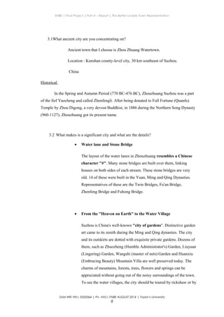
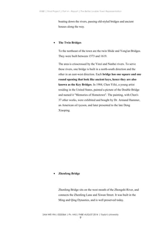
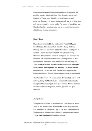
ENBE | Final Project | Part A – Report | The Better Livable Town Representation
Better Livable Town
The Circular
NAME : SAM WEI YIN
STUDENT ID : 0320364
FNBE AUGUST 2014
SAM WEI YIN| 0320364 | Pn. HAS| FNBE AUGUST 2014 | Taylor’s University
1
ENBE | Final Project | Part A – Report | The Better Livable Town Representation
Content:
1. Introduction
2. A Town Investigation on Better Township or Town or City Guidelines and Issues
3. Investigation & Data Collection: Ancient and old cities/town
4. Investigation & Data Collection: The present towns/cities
5. Investigation & Data Collection: The future and better township
6. The New “X” Town / Or the new name
7. The Conclusion
8. References list
SAM WEI YIN| 0320364 | Pn. HAS| FNBE AUGUST 2014 | Taylor’s University
2
ENBE | Final Project | Part A – Report | The Better Livable Town Representation
Introduction
Our final project of Element of Natural and Build Environment (ENBE) is
build our own ‘X’ town. The objective of this project is to let us understand the component
and element of a town. Make you yourself as a mayor of the ‘X’ town, we are propose a new
layout of a new ‘X’ town, as a result of too crowded. First, we need to do research about a
town, what is a town, what are the requirement make a good town. Next what we have to do
are, some investigation of some ancient and present town. This is to let us know what should
be improved to build a better town.
In build a future town, we need to consider geometric shape, pattern, hierarchy,
system and structure of the town. Not only this, we need to plan on transportation,
infrastructure, energy use and etc on the town.
SAM WEI YIN| 0320364 | Pn. HAS| FNBE AUGUST 2014 | Taylor’s University
3
ENBE | Final Project | Part A – Report | The Better Livable Town Representation
The Town
1.1 The Town Definition
• a densely populated urban area, typically smaller than a city and larger than a
village, having some local powers of government and a fixed boundary
(as modifier): town life, related adjective urban
• a city, borough, or other urban area
SAM WEI YIN| 0320364 | Pn. HAS| FNBE AUGUST 2014 | Taylor’s University
4
ENBE | Final Project | Part A – Report | The Better Livable Town Representation
• (in the US) a territorial unit of local government that is smaller than a county;
township
1.2 What is the brief history
Basically different country had different brief history of town. In early years, town
could refer to kind of settlements as diverse as agricultural estate and holding, partly
picking up the Norse sense at the end of the scale, to municipality at the other.
Australian geographer Thomas Griffith Taylor proposed a classification of towns
based on their age and pattern of land use. He identified five types of town:[1]
• Infantile towns, with no clear zoning
• Juvenile towns, which have developed an area of shops
• Adolescent towns, where factories have started to appear
• Early mature towns, with a separate area of high-class housing
• Mature towns, with defined industrial, commercial and various types of
residential area
2.3 What makes a town?
A town must have living creature such as people. Besides that it also must
include town privileges given by government. Not only this, in a town also
include shelter, to provide food, clean water supply and place for business
and government.
SAM WEI YIN| 0320364 | Pn. HAS| FNBE AUGUST 2014 | Taylor’s University
5
ENBE | Final Project | Part A – Report | The Better Livable Town Representation
2.4 What make a good towns?
• Affordable residential area
• Job opportunity
• A safe water supply and sanitation system
• An easy access transportation network on every level
• Great education institution
• Protection form force like police station and armies
• Medical service, community service, and fire protection
• A steady economic growth
2.5 What is the future town?
For me, a future town should have more organizes and better living
environment than present town. It could provide better medical service,
education system and etc. Next, the first thing that come to our mind when
we think about a future town or city is full of tall building and high
technology.
SAM WEI YIN| 0320364 | Pn. HAS| FNBE AUGUST 2014 | Taylor’s University
6
ENBE | Final Project | Part A – Report | The Better Livable Town Representation
3.0 Investigation & Data Collection:
Ancient town- Zhuozhuang
Figure 3.1
Figure 3.2
SAM WEI YIN| 0320364 | Pn. HAS| FNBE AUGUST 2014 | Taylor’s University
7
ENBE | Final Project | Part A – Report | The Better Livable Town Representation
3.1What ancient city are you concentrating on?
Ancient town that I choose is Zhou Zhuang Watertown.
Location : Kunshan county-level city, 30 km southeast of Suzhou.
China
Historical
In the Spring and Autumn Period (770 BC-476 BC), Zhouzhuang Suzhou was a part
of the fief Yaocheng and called Zhenfengli. After being donated to Full Fortune (Quanfu)
Temple by Zhou Digong, a very devout Buddhist, in 1086 during the Northern Song Dynasty
(960-1127), Zhouzhuang got its present name.
3.2 What makes is a significant city and what are the details?
• Water lane and Stone Bridge
The layout of the water lanes in Zhouzhuang resembles a Chinese
character "#". Many stone bridges are built over them, linking
houses on both sides of each stream. These stone bridges are very
old. 14 of these were built in the Yuan, Ming and Qing Dynasties.
Representatives of these are the Twin Bridges, Fu'an Bridge,
Zhenfeng Bridge and Fuhong Bridge.
• From the "Heaven on Earth" to the Water Village
Suzhou is China's well-known "city of gardens". Distinctive garden
art came to its zenith during the Ming and Qing dynasties. The city
and its outskirts are dotted with exquisite private gardens. Dozens of
them, such as Zhuozheng (Humble Administrator's) Garden, Liuyuan
(Lingering) Garden, Wangshi (master of nets) Garden and Huanxiu
(Embracing Beauty) Mountain Villa are well preserved today. The
charms of mountains, forests, trees, flowers and springs can be
appreciated without going out of the noisy surroundings of the town.
To see the water villages, the city should be toured by rickshaw or by
SAM WEI YIN| 0320364 | Pn. HAS| FNBE AUGUST 2014 | Taylor’s University
8
ENBE | Final Project | Part A – Report | The Better Livable Town Representation
boating down the rivers, passing old-styled bridges and ancient
houses along the way.
• The Twin Bridges
To the northeast of the town are the twin Shide and Yong'an Bridges.
They were built between 1573 and 1619.
The area is crisscrossed by the Yinzi and Nanbei rivers. To serve
these rivers, one bridge is built in a north-south direction and the
other in an east-west direction. Each bridge has one square and one
round opening that look like ancient keys, hence they are also
known as the Key Bridges. In 1984, Chen Yifei, a young artist
residing in the United States, painted a picture of the Double Bridge
and named it "Memories of Hometown". The painting, with Chen's
37 other works, were exhibited and bought by Dr. Armand Hammer,
an American oil tycoon, and later presented to the late Deng
Xiaoping.
• Zhenfeng Bridge
Zhenfeng Bridge sits on the west mouth of the Zhongshi River, and
connects the Zhenfeng Lane and Xiwan Street. It was built in the
Ming and Qing Dynasties, and is well preserved today.
SAM WEI YIN| 0320364 | Pn. HAS| FNBE AUGUST 2014 | Taylor’s University
9
ENBE | Final Project | Part A – Report | The Better Livable Town Representation
Zhouzhuang has about 1000 households who are living in the old
dwelling quarters built in the Ming, Qing dynasties and the early
Republic of China. More than 60% of these houses are well
preserved. There are 100 houses with courtyards and 60 of these have
arch gateways made by carved bricks. The houses of both Zhang and
Shen families have remained intact and serve as excellent examples
of traditional Chinese architecture
• Shen's House
Shen's House is located to the southeast of Fu'an Bridge, on
Nanshi Street. Shen Benren built it in 1742 during the Qing
Dynasty. He was a descendant of Shen Wanshen: a wealthy man in
southern China in the late Yuan (1206-1368) to early Ming
Dynasties. The compound has seven courtyards, five archways and
more than 100 rooms of different sizes. Covering an area of 2000
square meters, it was built along both sides of a 100-m-long axis.
There are three sections. The first section includes the water gate
and wharf for mooring boats and washing. The second section
consists of the Tea Hall and Main Hall for receiving guests and
holding weddings or funerals. The rear part serves as living quarters.
The Main Hall covers 170 square meters. The 6-m-high carved brick
archway, facing the Main Hall, has a horizontal board bearing the
inscription Jihouliuguang (do more good forever). Around the board
are relief sculptures of figurines, animals, pavilions and opera
characters.
• Zhang's House
Zhang's House is located to the south of the Twin Bridge on Beishi
Street. It was built between 1436 and 1449 by the offspring of Xu
Kui, the brother of Zhongshan King Xu Da. After it was sold to the
Zhang family in the early Qing Dynasty, it became known as either
Yuyan (Jade Swallow) Hall or Zhang's House.
SAM WEI YIN| 0320364 | Pn. HAS| FNBE AUGUST 2014 | Taylor’s University
10
ENBE | Final Project | Part A – Report | The Better Livable Town Representation
Covering more than 1800 square meters, the house has 6 courtyards
and more than 70 rooms. The main courtyard has buildings facing
east and west, with long and short windows. Yuyan Hall is the main
building. The hall is large and bright with grand columns on large
pier bases, a rare Ming style. A river flows under the hall. A
square pool built in the middle section allows boats to turn
round. Its rear hall has open windows and balconies facing the water
with a backyard of various plants and flowers.
The place is now an important cultural relic under the protection
of the provincial government.
3.3 Conclusion about the cities
In conclusion, Zhouzhuang had find the way the to overcome problem facing
By town that build on land beside a river.
3.4 What information or element that you can use to your new future city
• The way they build water lane.
• Transportation.
• Structure of the bridge.
SAM WEI YIN| 0320364 | Pn. HAS| FNBE AUGUST 2014 | Taylor’s University
11
ENBE | Final Project | Part A – Report | The Better Livable Town Representation
4.0 Investigation & Data Collection:
SAM WEI YIN| 0320364 | Pn. HAS| FNBE AUGUST 2014 | Taylor’s University
12
ENBE | Final Project | Part A – Report | The Better Livable Town Representation
Present City- Seoul
Figure 4.1
Figure 4.2
SAM WEI YIN| 0320364 | Pn. HAS| FNBE AUGUST 2014 | Taylor’s University
13
ENBE | Final Project | Part A – Report | The Better Livable Town Representation
4.1 When did it start? History and all
Settlement of the Han River area, where present-day Seoul is located, began around 4000
BC. Seoul is first recorded as Wiryeseong, the capital of Baekje (founded in 18 BC) in the
northeastern Seoul area. There are several city walls remaining in the area that date from this
time. Pungnaptoseong, an earthen wall just outside Seoul, is widely believed to have been at
the main Wiryeseong site. As the Three Kingdoms competed for this strategic region, control
passed from Baekje to Goguryeo in the 5th century, and from Goguryeo to Silla in the 6th
century. In the 11th century Goryeo, which succeeded Unified Silla, built a summer palace in
Seoul, which was referred to as the "Southern Capital". It was only from this period that
Seoul became a larger settlementWhen Joseon replaced Goryeo, the capital was moved to
Seoul (also known as Hanyang and later as Hanseong), where it remained until the fall of the
dynasty. The Gyeongbok Palace, built in the 14th century, served as the royal residence until
1592. The other large palace, Changdeokgung, constructed in 1405, served as the main royal
palace from 1611 to 1872. Originally, the city was entirely surrounded by a massive circular
stone wall to provide its citizens security from wild animals, thieves and attacks. The city has
grown beyond those walls and although the wall no longer stands (except along Bugaksan
Mountain (북악산), north of the downtown area), the gates remain near the downtown district
of Seoul, including most notably Sungnyemun (commonly known as Namdaemun) and
Honginjimun (commonly known as Dongdaemun). During the Joseon dynasty, the gates were
opened and closed each day, accompanied by the ringing of large bells at the Bosingak belfry.
In the late 19th century, after hundreds of years of isolation, Seoul opened its gates to
foreigners and began to modernize. Seoul became the first city in East Asia to introduce
electricity in the royal palace, built by the Edison Illuminating Company and a decade later
Seoul also implemented electrical street lights. Much of the development was due to trade
with foreign countries like France and United States. For example, the Seoul Electric
Company, Seoul Electric Trolley Company, and Seoul Fresh Spring Water Company were all
joint Korean-American owned enterprises. In 1904, an American by the name of Angus
Hamilton visited the city and said, "The streets of Seoul are magnificent, spacious, clean,
admirably made and well-drained. The narrow, dirty lanes have been widened, gutters have
been covered, roadways broadened. Seoul is within measurable distance of becoming the
highest, most interesting and cleanest city in the East. After the Russo-Japanese War (1904-
1905), the Empire of Japan annexed Korea and renamed the city Gyeongseong. Japanese
technology was imported, the city walls were removed, some of the gates demolished. Roads
became paved and Western-style buildings were constructed. The city was liberated at the end
of World War II. In 1945 the city was officially named Seoul and designated as a special city
in 1949. During the Korean War, Seoul changed hands between the Russian/Chinese-backed
SAM WEI YIN| 0320364 | Pn. HAS| FNBE AUGUST 2014 | Taylor’s University
14
ENBE | Final Project | Part A – Report | The Better Livable Town Representation
North Korean forces and the American-backed South Korean forces several times, leaving the
city heavily damaged after the war. The capital was temporarily relocated to Busan. One
estimate of the extensive damage states that after the war, at least 191,000 buildings, 55,000
houses, and 1,000 factories lay in ruins. In addition, a flood of refugees had entered Seoul
during the war, swelling the population of the city and its metropolitan area to an estimated
1.5 million by 1955. Following the war, Seoul began to focus on reconstruction and
modernization. As Korea's economy started to grow rapidly from the 1960s, urbanization also
accelerated and workers began to move to Seoul and other larger cities. From the 1970s, the
size of Seoul administrative area greatly expanded as it annexed a number of towns and
villages from several surrounding counties. According to 2012 census data, the population of
the Seoul area makes up around 20% of the total population of South Korea, Seoul has
become the economic, political and cultural hub of the country, with several Fortune 500
companies, including Samsung, SK Holdings, Hyundai, POSCO and LG Group
headquartered there.Seoul was the host city of the 1986 Asian Games and 1988 Summer
Olympics as well as one of the venues of the Football World Cup 2002.
4.2 What makes is a significant city and what are the details?
• Architectural such as sungyemun, changdakgung, lotter world tower ( under
construction )
• Technology- Seoul has a very technologically advanced infrastructure. It has
the world's highest fiber-optic broadband penetration, resulting in the world's
fastest internet connections with speeds up to 1 Gbps. Seoul provides free
Wi-Fi access in outdoor spaces.
• Museum – there are 115 museum in Seoul.
• Park-There are a lot of park in Seoul and the largest indoor amusement park,
Lotte World. Other recreation centers include the former Olympic and
World Cup stadiums and the City Hall public lawn.
4.3 Conclusion about the city.
This city is a well planned city. In this city we not only can found tall
building but it also have recreation area.
4.4 What information or element that you can use to your new town
• Design of some building
SAM WEI YIN| 0320364 | Pn. HAS| FNBE AUGUST 2014 | Taylor’s University
15
ENBE | Final Project | Part A – Report | The Better Livable Town Representation
• Transportation network
• Park
5.0 Investigation & Data Collection:
The future of towns and Better Towns
Gwang Gyo Power Centre
SAM WEI YIN| 0320364 | Pn. HAS| FNBE AUGUST 2014 | Taylor’s University
16
ENBE | Final Project | Part A – Report | The Better Livable Town Representation
Figure 5.1
MVRDV architects have won the award to design the city centre of gwang gyo, located
approximately 35km south of Seoul, South Korea. The concept design consists of a
series of overgrown hill shaped buildings with great programmatic diversity, aiming for
high urban density and encouragement of further developments around the ‘power
centre’, one of the envisioned two centre’s of the future new town. the gwanggyo power
centre will consist of housing, offices, a mix of cultural, leisure and educational facilities
as well as parking. The hill shaped structure is constructed with a series of rings that
facilitate outdoor life each floor will consist of terraces with a floor to floor circulation
system in which water will be stored and used to irrigate plants. The roofs of these
hill and the terraces are planted with box hedges creating a strong, recognizable,
cohesive park. In each tower a number of voids connect to the atrium providing for light
and ventilation and creating semi-public spaces. The design aims to create a landscape
on that enlarges green qualities and that links the surrounding parks by turning the site
into a park. The entire new town will be a self sufficient city of 77,000 inhabitants.
SAM WEI YIN| 0320364 | Pn. HAS| FNBE AUGUST 2014 | Taylor’s University
17
ENBE | Final Project | Part A – Report | The Better Livable Town Representation
Figure 5.2
What can I take from future city?
• Concept of the green building
SAM WEI YIN| 0320364 | Pn. HAS| FNBE AUGUST 2014 | Taylor’s University
18
ENBE | Final Project | Part A – Report | The Better Livable Town Representation
• Design of the building which is ring shape
6.0 The Circular
6.1 How did you come out with this solution to create this new town?
The trend of human population is increasing. This causes the previous city
become crowded and could not sustain anymore. Besides, previous city is totally
polluted. Me as a mayor of the city I had to create a new town to my people to ensure
they could continue their live. I and my group member had choose a town on land
next to river or sea. The reason we choose this as our group theme is because we
could get our basic daily resource such as water supply. My new town is circular in
shape and the river will pass through the center of the circle.
6.2 Zoning of the town.
This town divide into 7 part which is education, residential area, government
building, business center, recreation area such as park, transportation center, research
center and place for agriculture.
6.3 What is the important element in this new town?
SAM WEI YIN| 0320364 | Pn. HAS| FNBE AUGUST 2014 | Taylor’s University
19
ENBE | Final Project | Part A – Report | The Better Livable Town Representation
The outer look of the residential and education building look like a mountain.
The roof and certain level of the building is cover by green features. Solar energy as
the main energy while hydro energy is second power supply. Next, transportation I
suggest for this town are subway, bus and bicycle. A water recharge area will be
located under the park.
6.3 Conclusion
This new town provide a new liveable place for human. It provide better
transportation system than previous. This town
SAM WEI YIN| 0320364 | Pn. HAS| FNBE AUGUST 2014 | Taylor’s University
20
ENBE | Final Project | Part A – Report | The Better Livable Town Representation
SAM WEI YIN| 0320364 | Pn. HAS| FNBE AUGUST 2014 | Taylor’s University
21
ENBE | Final Project | Part A – Report | The Better Livable Town Representation
SAM WEI YIN| 0320364 | Pn. HAS| FNBE AUGUST 2014 | Taylor’s University
22
ENBE | Final Project | Part A – Report | The Better Livable Town Representation
7.0 Conclusion
After this project, I understand that to plan and build a town is not easy. I had
did a lot of research about the shape, facility I need to put. Beside, I nee dto do some
research about some culture since our country had different races.
Last what I want to say were time management is really important. So, manage your
time well I could help a lot.
SAM WEI YIN| 0320364 | Pn. HAS| FNBE AUGUST 2014 | Taylor’s University
23
ENBE | Final Project | Part A – Report | The Better Livable Town Representation
SAM WEI YIN| 0320364 | Pn. HAS| FNBE AUGUST 2014 | Taylor’s University
24
ENBE | Final Project | Part A – Report | The Better Livable Town Representation
8.0 Reference Links
Australian Bureau of Statistics: Australian Standard Geographical Classification (ASGC)
2005
External links
http://www.chinahighlights.com/suzhou/attraction/zhouzhuang-water-town.htm
http://www.skyscrapercity.com/showthread.php?p=37665408
http://www.ssdarchitecture.com/tag/water/
http://www.seouldesign.or.kr/eng/program/city_gallery_info.jsp
http://en.wikipedia.org/wiki/Seoul
http://www.weingartnerarchitects.com/projects/masterplan/future-town/
http://www.designboom.com/architecture/mvrdv-architects-wins-gwanggyo-power-centre-
competition-in-south-korea/
http://discovermagazine.com/galleries/zen-photo/e/extreme-green-architecture
http://en.wikipedia.org/wiki/Zhouzhuang
SAM WEI YIN| 0320364 | Pn. HAS| FNBE AUGUST 2014 | Taylor’s University
25

Enbe report

  • 1.
    ENBE | FinalProject | Part A – Report | The Better Livable Town Representation Better Livable Town The Circular NAME : SAM WEI YIN STUDENT ID : 0320364 FNBE AUGUST 2014 SAM WEI YIN| 0320364 | Pn. HAS| FNBE AUGUST 2014 | Taylor’s University 1
  • 2.
    ENBE | FinalProject | Part A – Report | The Better Livable Town Representation Content: 1. Introduction 2. A Town Investigation on Better Township or Town or City Guidelines and Issues 3. Investigation & Data Collection: Ancient and old cities/town 4. Investigation & Data Collection: The present towns/cities 5. Investigation & Data Collection: The future and better township 6. The New “X” Town / Or the new name 7. The Conclusion 8. References list SAM WEI YIN| 0320364 | Pn. HAS| FNBE AUGUST 2014 | Taylor’s University 2
  • 3.
    ENBE | FinalProject | Part A – Report | The Better Livable Town Representation Introduction Our final project of Element of Natural and Build Environment (ENBE) is build our own ‘X’ town. The objective of this project is to let us understand the component and element of a town. Make you yourself as a mayor of the ‘X’ town, we are propose a new layout of a new ‘X’ town, as a result of too crowded. First, we need to do research about a town, what is a town, what are the requirement make a good town. Next what we have to do are, some investigation of some ancient and present town. This is to let us know what should be improved to build a better town. In build a future town, we need to consider geometric shape, pattern, hierarchy, system and structure of the town. Not only this, we need to plan on transportation, infrastructure, energy use and etc on the town. SAM WEI YIN| 0320364 | Pn. HAS| FNBE AUGUST 2014 | Taylor’s University 3
  • 4.
    ENBE | FinalProject | Part A – Report | The Better Livable Town Representation The Town 1.1 The Town Definition • a densely populated urban area, typically smaller than a city and larger than a village, having some local powers of government and a fixed boundary (as modifier): town life, related adjective urban • a city, borough, or other urban area SAM WEI YIN| 0320364 | Pn. HAS| FNBE AUGUST 2014 | Taylor’s University 4
  • 5.
    ENBE | FinalProject | Part A – Report | The Better Livable Town Representation • (in the US) a territorial unit of local government that is smaller than a county; township 1.2 What is the brief history Basically different country had different brief history of town. In early years, town could refer to kind of settlements as diverse as agricultural estate and holding, partly picking up the Norse sense at the end of the scale, to municipality at the other. Australian geographer Thomas Griffith Taylor proposed a classification of towns based on their age and pattern of land use. He identified five types of town:[1] • Infantile towns, with no clear zoning • Juvenile towns, which have developed an area of shops • Adolescent towns, where factories have started to appear • Early mature towns, with a separate area of high-class housing • Mature towns, with defined industrial, commercial and various types of residential area 2.3 What makes a town? A town must have living creature such as people. Besides that it also must include town privileges given by government. Not only this, in a town also include shelter, to provide food, clean water supply and place for business and government. SAM WEI YIN| 0320364 | Pn. HAS| FNBE AUGUST 2014 | Taylor’s University 5
  • 6.
    ENBE | FinalProject | Part A – Report | The Better Livable Town Representation 2.4 What make a good towns? • Affordable residential area • Job opportunity • A safe water supply and sanitation system • An easy access transportation network on every level • Great education institution • Protection form force like police station and armies • Medical service, community service, and fire protection • A steady economic growth 2.5 What is the future town? For me, a future town should have more organizes and better living environment than present town. It could provide better medical service, education system and etc. Next, the first thing that come to our mind when we think about a future town or city is full of tall building and high technology. SAM WEI YIN| 0320364 | Pn. HAS| FNBE AUGUST 2014 | Taylor’s University 6
  • 7.
    ENBE | FinalProject | Part A – Report | The Better Livable Town Representation 3.0 Investigation & Data Collection: Ancient town- Zhuozhuang Figure 3.1 Figure 3.2 SAM WEI YIN| 0320364 | Pn. HAS| FNBE AUGUST 2014 | Taylor’s University 7
  • 8.
    ENBE | FinalProject | Part A – Report | The Better Livable Town Representation 3.1What ancient city are you concentrating on? Ancient town that I choose is Zhou Zhuang Watertown. Location : Kunshan county-level city, 30 km southeast of Suzhou. China Historical In the Spring and Autumn Period (770 BC-476 BC), Zhouzhuang Suzhou was a part of the fief Yaocheng and called Zhenfengli. After being donated to Full Fortune (Quanfu) Temple by Zhou Digong, a very devout Buddhist, in 1086 during the Northern Song Dynasty (960-1127), Zhouzhuang got its present name. 3.2 What makes is a significant city and what are the details? • Water lane and Stone Bridge The layout of the water lanes in Zhouzhuang resembles a Chinese character "#". Many stone bridges are built over them, linking houses on both sides of each stream. These stone bridges are very old. 14 of these were built in the Yuan, Ming and Qing Dynasties. Representatives of these are the Twin Bridges, Fu'an Bridge, Zhenfeng Bridge and Fuhong Bridge. • From the "Heaven on Earth" to the Water Village Suzhou is China's well-known "city of gardens". Distinctive garden art came to its zenith during the Ming and Qing dynasties. The city and its outskirts are dotted with exquisite private gardens. Dozens of them, such as Zhuozheng (Humble Administrator's) Garden, Liuyuan (Lingering) Garden, Wangshi (master of nets) Garden and Huanxiu (Embracing Beauty) Mountain Villa are well preserved today. The charms of mountains, forests, trees, flowers and springs can be appreciated without going out of the noisy surroundings of the town. To see the water villages, the city should be toured by rickshaw or by SAM WEI YIN| 0320364 | Pn. HAS| FNBE AUGUST 2014 | Taylor’s University 8
  • 9.
    ENBE | FinalProject | Part A – Report | The Better Livable Town Representation boating down the rivers, passing old-styled bridges and ancient houses along the way. • The Twin Bridges To the northeast of the town are the twin Shide and Yong'an Bridges. They were built between 1573 and 1619. The area is crisscrossed by the Yinzi and Nanbei rivers. To serve these rivers, one bridge is built in a north-south direction and the other in an east-west direction. Each bridge has one square and one round opening that look like ancient keys, hence they are also known as the Key Bridges. In 1984, Chen Yifei, a young artist residing in the United States, painted a picture of the Double Bridge and named it "Memories of Hometown". The painting, with Chen's 37 other works, were exhibited and bought by Dr. Armand Hammer, an American oil tycoon, and later presented to the late Deng Xiaoping. • Zhenfeng Bridge Zhenfeng Bridge sits on the west mouth of the Zhongshi River, and connects the Zhenfeng Lane and Xiwan Street. It was built in the Ming and Qing Dynasties, and is well preserved today. SAM WEI YIN| 0320364 | Pn. HAS| FNBE AUGUST 2014 | Taylor’s University 9
  • 10.
    ENBE | FinalProject | Part A – Report | The Better Livable Town Representation Zhouzhuang has about 1000 households who are living in the old dwelling quarters built in the Ming, Qing dynasties and the early Republic of China. More than 60% of these houses are well preserved. There are 100 houses with courtyards and 60 of these have arch gateways made by carved bricks. The houses of both Zhang and Shen families have remained intact and serve as excellent examples of traditional Chinese architecture • Shen's House Shen's House is located to the southeast of Fu'an Bridge, on Nanshi Street. Shen Benren built it in 1742 during the Qing Dynasty. He was a descendant of Shen Wanshen: a wealthy man in southern China in the late Yuan (1206-1368) to early Ming Dynasties. The compound has seven courtyards, five archways and more than 100 rooms of different sizes. Covering an area of 2000 square meters, it was built along both sides of a 100-m-long axis. There are three sections. The first section includes the water gate and wharf for mooring boats and washing. The second section consists of the Tea Hall and Main Hall for receiving guests and holding weddings or funerals. The rear part serves as living quarters. The Main Hall covers 170 square meters. The 6-m-high carved brick archway, facing the Main Hall, has a horizontal board bearing the inscription Jihouliuguang (do more good forever). Around the board are relief sculptures of figurines, animals, pavilions and opera characters. • Zhang's House Zhang's House is located to the south of the Twin Bridge on Beishi Street. It was built between 1436 and 1449 by the offspring of Xu Kui, the brother of Zhongshan King Xu Da. After it was sold to the Zhang family in the early Qing Dynasty, it became known as either Yuyan (Jade Swallow) Hall or Zhang's House. SAM WEI YIN| 0320364 | Pn. HAS| FNBE AUGUST 2014 | Taylor’s University 10
  • 11.
    ENBE | FinalProject | Part A – Report | The Better Livable Town Representation Covering more than 1800 square meters, the house has 6 courtyards and more than 70 rooms. The main courtyard has buildings facing east and west, with long and short windows. Yuyan Hall is the main building. The hall is large and bright with grand columns on large pier bases, a rare Ming style. A river flows under the hall. A square pool built in the middle section allows boats to turn round. Its rear hall has open windows and balconies facing the water with a backyard of various plants and flowers. The place is now an important cultural relic under the protection of the provincial government. 3.3 Conclusion about the cities In conclusion, Zhouzhuang had find the way the to overcome problem facing By town that build on land beside a river. 3.4 What information or element that you can use to your new future city • The way they build water lane. • Transportation. • Structure of the bridge. SAM WEI YIN| 0320364 | Pn. HAS| FNBE AUGUST 2014 | Taylor’s University 11
  • 12.
    ENBE | FinalProject | Part A – Report | The Better Livable Town Representation 4.0 Investigation & Data Collection: SAM WEI YIN| 0320364 | Pn. HAS| FNBE AUGUST 2014 | Taylor’s University 12
  • 13.
    ENBE | FinalProject | Part A – Report | The Better Livable Town Representation Present City- Seoul Figure 4.1 Figure 4.2 SAM WEI YIN| 0320364 | Pn. HAS| FNBE AUGUST 2014 | Taylor’s University 13
  • 14.
    ENBE | FinalProject | Part A – Report | The Better Livable Town Representation 4.1 When did it start? History and all Settlement of the Han River area, where present-day Seoul is located, began around 4000 BC. Seoul is first recorded as Wiryeseong, the capital of Baekje (founded in 18 BC) in the northeastern Seoul area. There are several city walls remaining in the area that date from this time. Pungnaptoseong, an earthen wall just outside Seoul, is widely believed to have been at the main Wiryeseong site. As the Three Kingdoms competed for this strategic region, control passed from Baekje to Goguryeo in the 5th century, and from Goguryeo to Silla in the 6th century. In the 11th century Goryeo, which succeeded Unified Silla, built a summer palace in Seoul, which was referred to as the "Southern Capital". It was only from this period that Seoul became a larger settlementWhen Joseon replaced Goryeo, the capital was moved to Seoul (also known as Hanyang and later as Hanseong), where it remained until the fall of the dynasty. The Gyeongbok Palace, built in the 14th century, served as the royal residence until 1592. The other large palace, Changdeokgung, constructed in 1405, served as the main royal palace from 1611 to 1872. Originally, the city was entirely surrounded by a massive circular stone wall to provide its citizens security from wild animals, thieves and attacks. The city has grown beyond those walls and although the wall no longer stands (except along Bugaksan Mountain (북악산), north of the downtown area), the gates remain near the downtown district of Seoul, including most notably Sungnyemun (commonly known as Namdaemun) and Honginjimun (commonly known as Dongdaemun). During the Joseon dynasty, the gates were opened and closed each day, accompanied by the ringing of large bells at the Bosingak belfry. In the late 19th century, after hundreds of years of isolation, Seoul opened its gates to foreigners and began to modernize. Seoul became the first city in East Asia to introduce electricity in the royal palace, built by the Edison Illuminating Company and a decade later Seoul also implemented electrical street lights. Much of the development was due to trade with foreign countries like France and United States. For example, the Seoul Electric Company, Seoul Electric Trolley Company, and Seoul Fresh Spring Water Company were all joint Korean-American owned enterprises. In 1904, an American by the name of Angus Hamilton visited the city and said, "The streets of Seoul are magnificent, spacious, clean, admirably made and well-drained. The narrow, dirty lanes have been widened, gutters have been covered, roadways broadened. Seoul is within measurable distance of becoming the highest, most interesting and cleanest city in the East. After the Russo-Japanese War (1904- 1905), the Empire of Japan annexed Korea and renamed the city Gyeongseong. Japanese technology was imported, the city walls were removed, some of the gates demolished. Roads became paved and Western-style buildings were constructed. The city was liberated at the end of World War II. In 1945 the city was officially named Seoul and designated as a special city in 1949. During the Korean War, Seoul changed hands between the Russian/Chinese-backed SAM WEI YIN| 0320364 | Pn. HAS| FNBE AUGUST 2014 | Taylor’s University 14
  • 15.
    ENBE | FinalProject | Part A – Report | The Better Livable Town Representation North Korean forces and the American-backed South Korean forces several times, leaving the city heavily damaged after the war. The capital was temporarily relocated to Busan. One estimate of the extensive damage states that after the war, at least 191,000 buildings, 55,000 houses, and 1,000 factories lay in ruins. In addition, a flood of refugees had entered Seoul during the war, swelling the population of the city and its metropolitan area to an estimated 1.5 million by 1955. Following the war, Seoul began to focus on reconstruction and modernization. As Korea's economy started to grow rapidly from the 1960s, urbanization also accelerated and workers began to move to Seoul and other larger cities. From the 1970s, the size of Seoul administrative area greatly expanded as it annexed a number of towns and villages from several surrounding counties. According to 2012 census data, the population of the Seoul area makes up around 20% of the total population of South Korea, Seoul has become the economic, political and cultural hub of the country, with several Fortune 500 companies, including Samsung, SK Holdings, Hyundai, POSCO and LG Group headquartered there.Seoul was the host city of the 1986 Asian Games and 1988 Summer Olympics as well as one of the venues of the Football World Cup 2002. 4.2 What makes is a significant city and what are the details? • Architectural such as sungyemun, changdakgung, lotter world tower ( under construction ) • Technology- Seoul has a very technologically advanced infrastructure. It has the world's highest fiber-optic broadband penetration, resulting in the world's fastest internet connections with speeds up to 1 Gbps. Seoul provides free Wi-Fi access in outdoor spaces. • Museum – there are 115 museum in Seoul. • Park-There are a lot of park in Seoul and the largest indoor amusement park, Lotte World. Other recreation centers include the former Olympic and World Cup stadiums and the City Hall public lawn. 4.3 Conclusion about the city. This city is a well planned city. In this city we not only can found tall building but it also have recreation area. 4.4 What information or element that you can use to your new town • Design of some building SAM WEI YIN| 0320364 | Pn. HAS| FNBE AUGUST 2014 | Taylor’s University 15
  • 16.
    ENBE | FinalProject | Part A – Report | The Better Livable Town Representation • Transportation network • Park 5.0 Investigation & Data Collection: The future of towns and Better Towns Gwang Gyo Power Centre SAM WEI YIN| 0320364 | Pn. HAS| FNBE AUGUST 2014 | Taylor’s University 16
  • 17.
    ENBE | FinalProject | Part A – Report | The Better Livable Town Representation Figure 5.1 MVRDV architects have won the award to design the city centre of gwang gyo, located approximately 35km south of Seoul, South Korea. The concept design consists of a series of overgrown hill shaped buildings with great programmatic diversity, aiming for high urban density and encouragement of further developments around the ‘power centre’, one of the envisioned two centre’s of the future new town. the gwanggyo power centre will consist of housing, offices, a mix of cultural, leisure and educational facilities as well as parking. The hill shaped structure is constructed with a series of rings that facilitate outdoor life each floor will consist of terraces with a floor to floor circulation system in which water will be stored and used to irrigate plants. The roofs of these hill and the terraces are planted with box hedges creating a strong, recognizable, cohesive park. In each tower a number of voids connect to the atrium providing for light and ventilation and creating semi-public spaces. The design aims to create a landscape on that enlarges green qualities and that links the surrounding parks by turning the site into a park. The entire new town will be a self sufficient city of 77,000 inhabitants. SAM WEI YIN| 0320364 | Pn. HAS| FNBE AUGUST 2014 | Taylor’s University 17
  • 18.
    ENBE | FinalProject | Part A – Report | The Better Livable Town Representation Figure 5.2 What can I take from future city? • Concept of the green building SAM WEI YIN| 0320364 | Pn. HAS| FNBE AUGUST 2014 | Taylor’s University 18
  • 19.
    ENBE | FinalProject | Part A – Report | The Better Livable Town Representation • Design of the building which is ring shape 6.0 The Circular 6.1 How did you come out with this solution to create this new town? The trend of human population is increasing. This causes the previous city become crowded and could not sustain anymore. Besides, previous city is totally polluted. Me as a mayor of the city I had to create a new town to my people to ensure they could continue their live. I and my group member had choose a town on land next to river or sea. The reason we choose this as our group theme is because we could get our basic daily resource such as water supply. My new town is circular in shape and the river will pass through the center of the circle. 6.2 Zoning of the town. This town divide into 7 part which is education, residential area, government building, business center, recreation area such as park, transportation center, research center and place for agriculture. 6.3 What is the important element in this new town? SAM WEI YIN| 0320364 | Pn. HAS| FNBE AUGUST 2014 | Taylor’s University 19
  • 20.
    ENBE | FinalProject | Part A – Report | The Better Livable Town Representation The outer look of the residential and education building look like a mountain. The roof and certain level of the building is cover by green features. Solar energy as the main energy while hydro energy is second power supply. Next, transportation I suggest for this town are subway, bus and bicycle. A water recharge area will be located under the park. 6.3 Conclusion This new town provide a new liveable place for human. It provide better transportation system than previous. This town SAM WEI YIN| 0320364 | Pn. HAS| FNBE AUGUST 2014 | Taylor’s University 20
  • 21.
    ENBE | FinalProject | Part A – Report | The Better Livable Town Representation SAM WEI YIN| 0320364 | Pn. HAS| FNBE AUGUST 2014 | Taylor’s University 21
  • 22.
    ENBE | FinalProject | Part A – Report | The Better Livable Town Representation SAM WEI YIN| 0320364 | Pn. HAS| FNBE AUGUST 2014 | Taylor’s University 22
  • 23.
    ENBE | FinalProject | Part A – Report | The Better Livable Town Representation 7.0 Conclusion After this project, I understand that to plan and build a town is not easy. I had did a lot of research about the shape, facility I need to put. Beside, I nee dto do some research about some culture since our country had different races. Last what I want to say were time management is really important. So, manage your time well I could help a lot. SAM WEI YIN| 0320364 | Pn. HAS| FNBE AUGUST 2014 | Taylor’s University 23
  • 24.
    ENBE | FinalProject | Part A – Report | The Better Livable Town Representation SAM WEI YIN| 0320364 | Pn. HAS| FNBE AUGUST 2014 | Taylor’s University 24
  • 25.
    ENBE | FinalProject | Part A – Report | The Better Livable Town Representation 8.0 Reference Links Australian Bureau of Statistics: Australian Standard Geographical Classification (ASGC) 2005 External links http://www.chinahighlights.com/suzhou/attraction/zhouzhuang-water-town.htm http://www.skyscrapercity.com/showthread.php?p=37665408 http://www.ssdarchitecture.com/tag/water/ http://www.seouldesign.or.kr/eng/program/city_gallery_info.jsp http://en.wikipedia.org/wiki/Seoul http://www.weingartnerarchitects.com/projects/masterplan/future-town/ http://www.designboom.com/architecture/mvrdv-architects-wins-gwanggyo-power-centre- competition-in-south-korea/ http://discovermagazine.com/galleries/zen-photo/e/extreme-green-architecture http://en.wikipedia.org/wiki/Zhouzhuang SAM WEI YIN| 0320364 | Pn. HAS| FNBE AUGUST 2014 | Taylor’s University 25