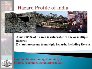
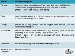
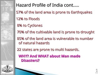
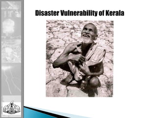
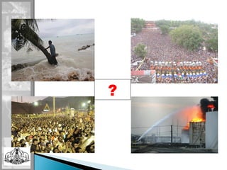
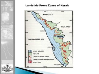
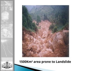
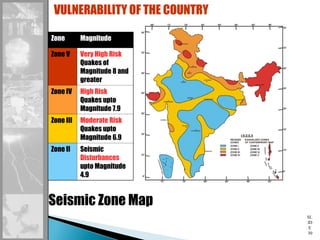
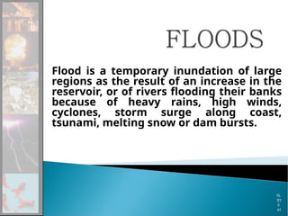
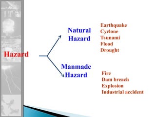
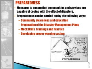
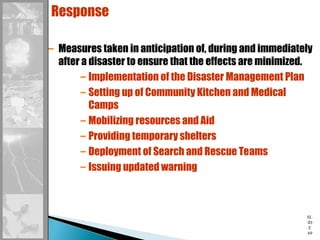
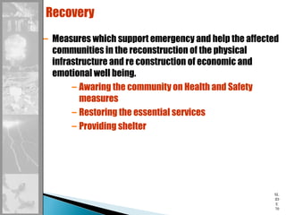
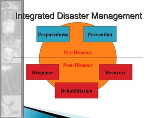
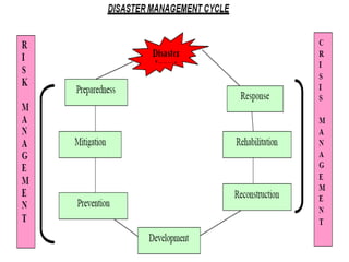
SL
ID
E 1
Almost 85% of its area is vulnerable to one or multiple
hazards
22 states are prone to multiple hazards, including Kerala
1 million houses damaged annually +
human, economic, social, other losses
Hazard Vulnerable regions
Cyclone Coastal areas – particularly the East coast & Gujarat. 8000 km long
coastline with two cyclone seasons (8% of total area in India)
(Kerala – moderate damage risk zone)
Flood Indo- Gangetic plains and 20 river basins across the country (approx.
40 million hectares prone to floods)
Drought Across the country (approx. 68% of cropped area affected) (low and
medium rainfall region)
Earthquake Across the country with moderate – high intensity (over 55%) 59%
according to the Indian Seismic Code 2002 BMTPC)
(Kerala – Zone – III – moderate damage risk zone - Quakes up to
Magnitude 6.9)
Landslide Sub-Himalayan region & western Ghats in particular
Industrial and
Chemical
Across the country
Hazard Profile of India cont…..
57% of the land area is prone to Earthquakes
12% to Floods
12% to Floods
8% to Cyclones
8% to Cyclones
70% of the cultivable land is prone to drought
85% of the land area is vulnerable to number
of natural hazards
of natural hazards
22 states are prone to multi hazards.
WHY? And WHAT about Man made
Disasters?
Disasters?
SL
ID
E 4
Disaster Vulnerability of Kerala
•
Kerala is classified as a multi-hazard prone state
as per the BMPTC map prepared by Government
of India.
• Earthquake vulnerability - Kerala is falling in
zone III, where moderate Intensity Earthquakes
(6.5 M Richter scale) are likely possible. Moderate
intensity earthquakes are as powerful as
Hiroshima atom Bomb.
• 96.9 percentage of the state is falling in the
Cyclone zone, where 140-158 km/hr speed winds
are likely possible.
• 14.8 percentage of total area of the state is
prone to flood during every year monsoon.
•
1600 sq.km area of the state is
vulnerable to landslides, which is
causing us heavy damages year after
year.
Epidemics such as Malaria, Dengu, Covid,
Chickenkuniya, Weil’s disease etc and
Biological Disasters such as pest attacks,
coconut mite, mahali in arecanut, red mite in
tea etc are also causing heavy damages.
SL
ID
E 7
Very high density of population in
the state makes it especially
vulnerable to natural disasters, its
after effects and consequences.
• Among all the disasters that occur in Kerala, river
• floods are the most frequent and devastating.
• Peculiarities of rainfall in the state are the major
• factor responsible for floods. Out of the total annual
• rainfall in the state, 75% is concentrated over the
• short monsoon season of three to four Months.
• As a result, heavy discharge of water from the
• catchments areas raises the water levels of the rivers
• during this period causing widespread floods.
• Earthquakes are considered to be one of the most
• dangerous and destructive natural hazards. The
• impact of this phenomenon is sudden with little or
• no warning, making it just impossible to predict or
• make preparations against damages and collapses
• of buildings and other man-made structures.
SL
ID
E 8
?
Landslide Prone Zones of Kerala
1500Km2
area prone to Landslide
 Earthquake in Pakistan – 2005
 Earthquake and tsunami in the Indian coast - 2004
 Gujarat Earthquake - 2001
 Floods in Mumbai, West Bengal, Orissa
 Cyclone: Rita, Wilma etc…..
 Fire: Kumbakonam, Dabwali
 Terrorist attack:
 Earthquake in Haithy
 Flood in Kerala in 2018
And the list goes on and
on……………
SL
ID
E
12
January 26, 2001, 0845 hours, an earthquake of
magnitude 6.9 on the ritcher scale struck near
Bhuj in the Kachchh region of Gujarat
People killed 18250
Houses destroyed 310657
Villages affected 3825
Total property loss Around 15000 crore rupees
SLIDE 13
A very severe cyclone hit Ganjam district of Orissa on
October 17, 1999 ; another cyclonic storm, much more
fierce one hit a wide area of coastal Orissa on October
29, 1999
SL
ID
E
15
People killed 9885
Houses destroyed/
damaged
16.5 lakh
Population affected 13 million people in 97
blocks and 28 urban areas
Total loss in agriculture
sector
1773 crore rupees
SL
ID
E
17
CASE 3: BHOPAL GAS LEAK DISASTER
During the night of December 2-3, 1984, MIC (Methyl Iso
Cynate) gas leaked from Union Carbide of India Ltd plant
in Bhopal, Madhya Pradesh
People killed 1754
People injured 2,00,000
CASE 4: THE SURAT PLAGUE EPIDEMIC
Plague outbreak in Surat on September 19, 1994
People killed 52
Cases reported 1088
TWO RECENT NATURAL DISASTERS AFFECTING
INDIAN SUBCONTINENT……
• December 26, 2004: A massive earthquake of magnitude
9.0 hit Indonesia generating tsunami waves in the South
East Asia and coastal India. The death toll in Indian
subcontinent was around 10000
• October 8, 2005: Earthquake measuring 7.6 on Ritcher
scale. Death toll in Pak Occupied Kashmir and
Pakisthan is around 78000. On Indian side around 1300
persons perished in the disaster.
SL
ID
E
20
DISASTER
Disruption in the normal pattern of life
Sudden/ severe/ unexpected/ wide spread
Caused by hazards: natural or man made
Human effects: Loss of life, livelihood, property,
adverse effects
on health
Environmental losses
Destruction/ damage of social as well as physical
infrastructure
Community needs such as shelter, food, clothing,
medical assistance and social care
Seeks external aid to cope up with the losses
SL
ID
E
21
A serious disruption of the functioning of the society,
caused by a hazard or otherwise, having widespread
human, material, environmental and other losses, which
exceed the ability of the affected society to cope using its
own resources.
DISASTER
SL
ID
E
22
TYPES OF DISASTER
Based on origin
Natural
Manmade
Geological
Water & Climate related
Biological
Accident Related
Chemical, industrial, nuclear
Based on nature
of onset
Rapid
Rapid/Slow
Slow
Cyclone, fire,
earthquake,
landslides
War, epidemics,
civil unrest
Drought ,
desertification,
pollution
SL
ID
E
23
GEOLOGICAL
– Earthquakes
– Landslides, Mudflows
– Dam Bursts & Dam Failures
– Mine Fires
TYPES OF DISASTER 1
SL
ID
E
24
WATER AND CLIMATE RELATED
– Floods and Drainage Management
– Cyclones
– Tornadoes & Hurricanes
– Hailstorm
– Cloud burst
– Snow Avalanches
– Heat & Cold Waves
– Thunder & Lightning
– Sea Erosion
– Droughts
TYPES OF DISASTER 2
SL
ID
E
25
ACCIDENT RELATED DISASTERS
– Road, Rail and other Transportation
accidents including Waterways
– Mine Flooding
– Major Building Collapse
– Serial Bomb Blasts
– Festival related Disasters
– Urban Fires
– Oil Spill
– Village Fires
– Boat Capsizing
– Forest Fires
– Electrical Disasters & Fires
TYPES OF DISASTER 3
SL
ID
E
26
CHEMICAL, INDUSTRIAL & NUCLEAR RELATED DISASTERS
– Chemical and Industrial Disasters
– Nuclear Disasters
TYPES OF DISASTER 4
SL
ID
E
27
BIOLOGICAL
– Biological Disasters & Epidemics
– Food Poisoning
– Cattle Epidemics
– Pest Attacks
– Covid 19
TYPES OF DISASTER 5
An Earthquake is a series of
underground shock waves and
movements on the earth’s surface
caused by natural processes within the
earths crust.
SL
ID
E
28
SL
ID
E
29
Measuring A Quake
Two measurements that describe the size of an earthquake
are:
Magnitude – estimates the amount of energy released at
the source of the earthquake. The Richter Magnitude Scale
Intensity – a measure of the degree of earthquake shaking
at a given location based on the amount of damage. The
Mercalli Intensity Scale
SL
ID
E
30
Seismic Zone Map
VULNERABILITY OF THE COUNTRY
Zone Magnitude
Zone V Very High Risk
Quakes of
Magnitude 8 and
greater
Zone IV High Risk
Quakes upto
Magnitude 7.9
Zone III Moderate Risk
Quakes upto
Magnitude 6.9
Zone II Seismic
Disturbances
upto Magnitude
4.9
SL
ID
E
31
Source: Are you prepared? Learning from the Great Hanshin-Awaji Earthquake Disaster HANDBOOKfor Disaster Reduction and Volunteer Activities Pg 3
EARTHQUAKES result in ………
SL
ID
E
32
WHAT IS A TSUNAMI…
A tsunami can be generated by ANY disturbance that
displaces a large water mass from its equilibrium position!
The displacement can be caused by an earthquake, a
landslide, a volcanic eruption..
 Tsunami or Harbor Wave
A Japanese word represented by
two characters: tsu & nami
tsu means harbor
&
nami means wave
SL
ID
E
33
• Know your community’s Tsunami hazard,
vulnerability and risk.
• Avoid new Development in Tsunami run-up
areas
• Configure unavoidable new development
• Design & construct new structures to minimise
Tsunami damage
• Protect existing development through
retrofitting
• Special precautions in locating & designing
infrastructure & critical facilities
• Plan for evacuation
SL
ID
E
34
Landslides are slippery masses of
rock, earth or debris which move
by force of their own weight
down mountain slopes or river
banks.
SL
ID
E
35
SL
ID
E
36
Though they occur gradually, sudden failure
can occur without warning
 They may take place in combination with
earthquakes, floods and volcanoes
Difficult to predict the actual occurrence.
Areas with high risk can be determined by use
of information on geology, hydrology,
vegetation cover, past occurrence and
consequences in the region.
SL
ID
E
37
 Cutting and levelling for construction of houses on the
toe region of slopes having more than 25% inclination
and length exceeding 100 m.
 Diversion or blocking of stream channels (up to third
order) in the upper slopes especially above settlement.
 Ponding of water in the sloping sections.
 Soil conservation practises through contour bunding,
terracing etc. in slopes of more than 25%.
 Seasonal cultivation with tilling or pitting activity in the
high sloping areas.
 Any activity in those sections where either ground
cracks or piping has been initiated.
 Encroachment of stream banks in the highland region
for cultivation or settlement.
 Alignment of open irrigation channels on hill flanks with
more than 25% slope.
 Construction of roads with out adequate engineering
design in the unstable slopes especially in those
segments having higher soil thickness. The hollow
portions are to be treated carefully
 Drainage of excess rainwater from steeper
sections of slope.
 Afforestation/ tree crops with no tilling activity in
such areas with more than 33% slopes.
 Maintenance of tree belts at suitable intervals in
those slopes subjected to seasonal cultivation.
 Studies to delineate stable and unstable areas in
the uppermost catchments of drainage basins.
 Settlement / developmental activity in high slopes
only after a proper evaluation of the area.
 Preservation of existing patches of natural forest
cover.
 Permanent grass cover in extremely sloping
sections (> 50% slope).
 Awareness among the local population on the
phenomenon of landslides
Flood is a temporary inundation of large
regions as the result of an increase in the
reservoir, or of rivers flooding their banks
because of heavy rains, high winds,
cyclones, storm surge along coast,
tsunami, melting snow or dam bursts.
SL
ID
E
45
RIVER FLOOD
COASTAL FLOOD
FLASH FLOOD
URBAN FLOODS
SL
ID
E
46
Cyclones are intense low-pressure
systems that develop in the oceanic
areas.
The cyclone blows in a large spiral
around a relatively calm centre or
eye, in clockwise direction in the
Northern hemisphere and in an
anticlockwise direction in the
Southern hemisphere.
SL
ID
E
47
The development of a tropical cyclone can be divided
into three stages
 Formation and Initial development stage
Full maturity
Modification or Decay
Four atmospheric and oceanic conditions are necessary for
the development of a cyclonic storm
Warm sea, temperature > 26O
C
High Relative Humidity
Atmospheric instability
Location of at least 4 to 6 degrees from Equator
SL
ID
E
48
DESTRUCTIVE WINDS
STORM SURGE
EXCEPTIONAL RAINFALL AND FLOODING
SL
ID
E
49
• Between 80 to 100 tropical cyclones occur
around the world every year.
• 8 % of the total land area in India is prone
to cyclones.
• About 2/3 of the cyclones that occur in the
Indian coastline occur in the Bay of Bengal.
• It has two seasons namely
– In the pre monsoon season i.e in the month of
April to early June
– secondly in the post monsoon season i.e in the
month of October to early December
SL
ID
E
50
• Indian Meteorological Department is the
Nodal Agency for wind detection, tracking
and forecasting cyclones.
• Cyclone warning is provided by the IMD
from the Area Cyclone Warning Centers
(ACWCs) at Kolkata, Chennai and Mumbai
• Cyclone Warning Stages
– Pre Cyclone watch
– Cyclone alert – 48 hours before the cyclone strikes
– Cyclone Warning – 24 hours in advance
– Post Landfall Scenario
SL
ID
E
52
All of us are at R I S K
SL
ID
E
54
Risk is a measure of the expected
losses (deaths, injuries, property,
economic activity etc) due to a
hazard of a particular magnitude
occurring in a given area over a
specific time period.
SL
ID
E
55
Risk
Hazard  Vulnerability
=
Capacity
SL
ID
E
57
VULNERABILITY:
The extent to which a community, structure, service, or
geographic area is likely to be damaged or disrupted by
the impact of a particular hazard on account of their
nature, construction, and proximity to a hazardous terrain
or a disaster prone area.
PHYSICAL
VULNERABILITIES
SOCIO ECONOMIC
VULNERABILITIES
LOSSES DUE TO
DISASTERS
SL
ID
E
58
HAZARD:
Phenomena that pose a threat to people, structure or
assets and which may cause a disaster.
•Natural Hazards (Hazards with meteorological,
geological or biological origin)
•Unnatural Hazards (Hazards with human-caused or
technological origin)
Hazard
Natural
Hazard
Earthquake
Cyclone
Tsunami
Flood
Drought
Manmade
Hazard Fire
Dam breach
Explosion
Industrial accident
SL
ID
E
60
RISK:
Risk is a measure of the expected losses due to a hazard
event of a particular magnitude occurring in a given area
over a specific time period.
RISK = HAZARD + VULNERABILITY- CAPACITY
CAPACITY:
Capacity is the resources of individuals, households and
communities to cope with a threat or resist the impact of a
hazard.
1. Preparedness
This protective process embraces
measures which enable governments,
communities and individuals to respond rapidly
to disaster situations to cope with them
effectively.
Preparedness includes the formulation of
viable emergency plans, the development of
warning systems, the maintenance of inventories
and the training of personnel. It may also
embrace search and rescue measures as well as
evacuation plans for areas that may be at risk
from a recurring disaster. SL
ID
E
61
Preparedness therefore encompasses those
measures taken before a disaster event which
are aimed at minimising loss of life, disruption
of critical services, and damage when the
disaster occurs.
All preparedness planning needs to be
supported by appropriate legislation with clear
allocation of responsibilities and budgetary
provisions.
SL
ID
E
62
SL
ID
E
63
Mitigation embraces all measures taken to reduce both the
effect of the hazard itself and the vulnerable conditions to it in
order to reduce the scale of a future disaster.
Examples of mitigation measures which are hazard specific
include modifying the occurrence of the hazard, e.g. Water
management in drought prone areas, avoiding the hazard by
sitting people away from the hazard and by strengthening
structures to reduce damage when a hazard occurs.
Mitigation should also be aimed at reducing the physical,
economic and social vulnerability to threats and the underlying
causes for this vulnerability.
SL
ID
E
64
Mitigation
– It involves long term measures to reduce the effects of
disaster causing phenomena
Mitigation:
Non-
Structural
& Structural
SL
ID
E
65
SL
ID
E
66
DISASTER MANAGEMENT
Disaster Management can be defined as the body of policy
and administrative decisions and operational activities
which pertain to various stages (pre-disaster, disaster
occurrence & post-disaster) of disaster at all levels.
Prevention
Mitigation
Preparedness
Response
Recovery
Rehabilitation
SL
ID
E
67
Prevention
– Measures to eliminate or reduce the incidence of
severity of emergencies/disasters.
– Preventing habitation in risk zones
– Construction of disaster resistant structures
like cyclone shelters, embankments etc.
– Community awareness and education
SL
ID
E
68
– Measures to ensure that communities and services are
capable of coping with the effect of disasters.
– Preparedness can be carried out by the following ways:
– Community awareness and education
– Preparation of the Disaster Management Plans
– Mock Drills, Trainings and Practice
– Developing proper warning system
PREPAREDNESS
SL
ID
E
69
Response
– Measures taken in anticipation of, during and immediately
after a disaster to ensure that the effects are minimized.
– Implementation of the Disaster Management Plan
– Setting up of Community Kitchen and Medical
Camps
– Mobilizing resources and Aid
– Providing temporary shelters
– Deployment of Search and Rescue Teams
– Issuing updated warning
SL
ID
E
70
Recovery
– Measures which support emergency and help the affected
communities in the reconstruction of the physical
infrastructure and re construction of economic and
emotional well being.
– Awaring the community on Health and Safety
measures
– Restoring the essential services
– Providing shelter
Pre-Disaster
Post-Disaster
Preparedness
Recovery
Rehabilitation
Response
Prevention
Integrated Disaster Management
SL
ID
E
73
A process of disaster risk
management in which at risk communities are
actively engaged in the identification, analysis,
treatment, monitoring and evaluation of disaster
risks in order to reduce their vulnerabilities and
enhance their capacities.
The people are at the heart of decision making
and implementation of disaster risk management
activities. The involvement of the most vulnerable
is paramount and the support of the least
vulnerable is necessary. In CBDRM, local and
national governments are involved and
supportive
SL
ID
E
74
Nobody can understand local opportunities and
constraints better than the local communities
themselves.
Nobody is more interested in understanding local
affairs than the community whose survival and
well-being is at stake.
SL
ID
E
75
Mock Drills
Street Plays
State Disaster Management Authority
Chief
Minister
Revenue
Minister
Principal
Secretary (Revenue)
Principal Secretary
(Home)
Chief
Secretary
Three
Experts
Revenue
Minister
Principal Secretary (Revenue)
Institute of Land and Disaster
Management
Disaster Management Department
District Collectors
Institutional Framework
Role of a SWr in DM
•Disaster Prevention
•Awareness creation- IEC
•Strengthening DM Team – Networking
•Evacuation
•Ensuring safety, food, medicines, cloth
•Trauma counseling
• Relief & Rehabilitation
The activist is not the man who
says the river is dirty. The activist
is the man who cleans up the
river.
Ross Perot
SL
ID
E
80
Cherish the past
Adorn the present
And act for the future (zf)

Disaster Management stages , importance, stages

  • 1.
  • 2.
    Almost 85% ofits area is vulnerable to one or multiple hazards 22 states are prone to multiple hazards, including Kerala 1 million houses damaged annually + human, economic, social, other losses
  • 3.
    Hazard Vulnerable regions CycloneCoastal areas – particularly the East coast & Gujarat. 8000 km long coastline with two cyclone seasons (8% of total area in India) (Kerala – moderate damage risk zone) Flood Indo- Gangetic plains and 20 river basins across the country (approx. 40 million hectares prone to floods) Drought Across the country (approx. 68% of cropped area affected) (low and medium rainfall region) Earthquake Across the country with moderate – high intensity (over 55%) 59% according to the Indian Seismic Code 2002 BMTPC) (Kerala – Zone – III – moderate damage risk zone - Quakes up to Magnitude 6.9) Landslide Sub-Himalayan region & western Ghats in particular Industrial and Chemical Across the country
  • 4.
    Hazard Profile ofIndia cont….. Hazard Profile of India cont….. 57% of the land area is prone to Earthquakes 57% of the land area is prone to Earthquakes 12% to Floods 12% to Floods 8% to Cyclones 8% to Cyclones 70% of the cultivable land is prone to drought 70% of the cultivable land is prone to drought 85% of the land area is vulnerable to number 85% of the land area is vulnerable to number of natural hazards of natural hazards 22 states are prone to multi hazards. 22 states are prone to multi hazards. WHY? And WHAT about Man made WHY? And WHAT about Man made Disasters? Disasters? SL ID E 4
  • 5.
  • 6.
    • Kerala is classifiedas a multi-hazard prone state as per the BMPTC map prepared by Government of India. • Earthquake vulnerability - Kerala is falling in zone III, where moderate Intensity Earthquakes (6.5 M Richter scale) are likely possible. Moderate intensity earthquakes are as powerful as Hiroshima atom Bomb. • 96.9 percentage of the state is falling in the Cyclone zone, where 140-158 km/hr speed winds are likely possible. • 14.8 percentage of total area of the state is prone to flood during every year monsoon. •
  • 7.
    1600 sq.km areaof the state is vulnerable to landslides, which is causing us heavy damages year after year. Epidemics such as Malaria, Dengu, Covid, Chickenkuniya, Weil’s disease etc and Biological Disasters such as pest attacks, coconut mite, mahali in arecanut, red mite in tea etc are also causing heavy damages. SL ID E 7 Very high density of population in the state makes it especially vulnerable to natural disasters, its after effects and consequences.
  • 8.
    • Among allthe disasters that occur in Kerala, river • floods are the most frequent and devastating. • Peculiarities of rainfall in the state are the major • factor responsible for floods. Out of the total annual • rainfall in the state, 75% is concentrated over the • short monsoon season of three to four Months. • As a result, heavy discharge of water from the • catchments areas raises the water levels of the rivers • during this period causing widespread floods. • Earthquakes are considered to be one of the most • dangerous and destructive natural hazards. The • impact of this phenomenon is sudden with little or • no warning, making it just impossible to predict or • make preparations against damages and collapses • of buildings and other man-made structures. SL ID E 8
  • 9.
  • 10.
  • 11.
  • 12.
     Earthquake inPakistan – 2005  Earthquake and tsunami in the Indian coast - 2004  Gujarat Earthquake - 2001  Floods in Mumbai, West Bengal, Orissa  Cyclone: Rita, Wilma etc…..  Fire: Kumbakonam, Dabwali  Terrorist attack:  Earthquake in Haithy  Flood in Kerala in 2018 And the list goes on and on…………… SL ID E 12
  • 13.
    January 26, 2001,0845 hours, an earthquake of magnitude 6.9 on the ritcher scale struck near Bhuj in the Kachchh region of Gujarat People killed 18250 Houses destroyed 310657 Villages affected 3825 Total property loss Around 15000 crore rupees SLIDE 13
  • 15.
    A very severecyclone hit Ganjam district of Orissa on October 17, 1999 ; another cyclonic storm, much more fierce one hit a wide area of coastal Orissa on October 29, 1999 SL ID E 15 People killed 9885 Houses destroyed/ damaged 16.5 lakh Population affected 13 million people in 97 blocks and 28 urban areas Total loss in agriculture sector 1773 crore rupees
  • 17.
    SL ID E 17 CASE 3: BHOPALGAS LEAK DISASTER During the night of December 2-3, 1984, MIC (Methyl Iso Cynate) gas leaked from Union Carbide of India Ltd plant in Bhopal, Madhya Pradesh People killed 1754 People injured 2,00,000 CASE 4: THE SURAT PLAGUE EPIDEMIC Plague outbreak in Surat on September 19, 1994 People killed 52 Cases reported 1088
  • 18.
    TWO RECENT NATURALDISASTERS AFFECTING INDIAN SUBCONTINENT…… • December 26, 2004: A massive earthquake of magnitude 9.0 hit Indonesia generating tsunami waves in the South East Asia and coastal India. The death toll in Indian subcontinent was around 10000 • October 8, 2005: Earthquake measuring 7.6 on Ritcher scale. Death toll in Pak Occupied Kashmir and Pakisthan is around 78000. On Indian side around 1300 persons perished in the disaster.
  • 20.
    SL ID E 20 DISASTER Disruption in thenormal pattern of life Sudden/ severe/ unexpected/ wide spread Caused by hazards: natural or man made Human effects: Loss of life, livelihood, property, adverse effects on health Environmental losses Destruction/ damage of social as well as physical infrastructure Community needs such as shelter, food, clothing, medical assistance and social care Seeks external aid to cope up with the losses
  • 21.
    SL ID E 21 A serious disruptionof the functioning of the society, caused by a hazard or otherwise, having widespread human, material, environmental and other losses, which exceed the ability of the affected society to cope using its own resources. DISASTER
  • 22.
    SL ID E 22 TYPES OF DISASTER Basedon origin Natural Manmade Geological Water & Climate related Biological Accident Related Chemical, industrial, nuclear Based on nature of onset Rapid Rapid/Slow Slow Cyclone, fire, earthquake, landslides War, epidemics, civil unrest Drought , desertification, pollution
  • 23.
    SL ID E 23 GEOLOGICAL – Earthquakes – Landslides,Mudflows – Dam Bursts & Dam Failures – Mine Fires TYPES OF DISASTER 1
  • 24.
    SL ID E 24 WATER AND CLIMATERELATED – Floods and Drainage Management – Cyclones – Tornadoes & Hurricanes – Hailstorm – Cloud burst – Snow Avalanches – Heat & Cold Waves – Thunder & Lightning – Sea Erosion – Droughts TYPES OF DISASTER 2
  • 25.
    SL ID E 25 ACCIDENT RELATED DISASTERS –Road, Rail and other Transportation accidents including Waterways – Mine Flooding – Major Building Collapse – Serial Bomb Blasts – Festival related Disasters – Urban Fires – Oil Spill – Village Fires – Boat Capsizing – Forest Fires – Electrical Disasters & Fires TYPES OF DISASTER 3
  • 26.
    SL ID E 26 CHEMICAL, INDUSTRIAL &NUCLEAR RELATED DISASTERS – Chemical and Industrial Disasters – Nuclear Disasters TYPES OF DISASTER 4
  • 27.
    SL ID E 27 BIOLOGICAL – Biological Disasters& Epidemics – Food Poisoning – Cattle Epidemics – Pest Attacks – Covid 19 TYPES OF DISASTER 5
  • 28.
    An Earthquake isa series of underground shock waves and movements on the earth’s surface caused by natural processes within the earths crust. SL ID E 28
  • 29.
    SL ID E 29 Measuring A Quake Twomeasurements that describe the size of an earthquake are: Magnitude – estimates the amount of energy released at the source of the earthquake. The Richter Magnitude Scale Intensity – a measure of the degree of earthquake shaking at a given location based on the amount of damage. The Mercalli Intensity Scale
  • 30.
    SL ID E 30 Seismic Zone Map VULNERABILITYOF THE COUNTRY Zone Magnitude Zone V Very High Risk Quakes of Magnitude 8 and greater Zone IV High Risk Quakes upto Magnitude 7.9 Zone III Moderate Risk Quakes upto Magnitude 6.9 Zone II Seismic Disturbances upto Magnitude 4.9
  • 31.
    SL ID E 31 Source: Are youprepared? Learning from the Great Hanshin-Awaji Earthquake Disaster HANDBOOKfor Disaster Reduction and Volunteer Activities Pg 3 EARTHQUAKES result in ………
  • 32.
    SL ID E 32 WHAT IS ATSUNAMI… A tsunami can be generated by ANY disturbance that displaces a large water mass from its equilibrium position! The displacement can be caused by an earthquake, a landslide, a volcanic eruption..
  • 33.
     Tsunami orHarbor Wave A Japanese word represented by two characters: tsu & nami tsu means harbor & nami means wave SL ID E 33
  • 34.
    • Know yourcommunity’s Tsunami hazard, vulnerability and risk. • Avoid new Development in Tsunami run-up areas • Configure unavoidable new development • Design & construct new structures to minimise Tsunami damage • Protect existing development through retrofitting • Special precautions in locating & designing infrastructure & critical facilities • Plan for evacuation SL ID E 34
  • 35.
    Landslides are slipperymasses of rock, earth or debris which move by force of their own weight down mountain slopes or river banks. SL ID E 35
  • 36.
    SL ID E 36 Though they occurgradually, sudden failure can occur without warning  They may take place in combination with earthquakes, floods and volcanoes Difficult to predict the actual occurrence. Areas with high risk can be determined by use of information on geology, hydrology, vegetation cover, past occurrence and consequences in the region.
  • 37.
  • 38.
     Cutting andlevelling for construction of houses on the toe region of slopes having more than 25% inclination and length exceeding 100 m.  Diversion or blocking of stream channels (up to third order) in the upper slopes especially above settlement.  Ponding of water in the sloping sections.  Soil conservation practises through contour bunding, terracing etc. in slopes of more than 25%.  Seasonal cultivation with tilling or pitting activity in the high sloping areas.  Any activity in those sections where either ground cracks or piping has been initiated.  Encroachment of stream banks in the highland region for cultivation or settlement.  Alignment of open irrigation channels on hill flanks with more than 25% slope.  Construction of roads with out adequate engineering design in the unstable slopes especially in those segments having higher soil thickness. The hollow portions are to be treated carefully
  • 39.
     Drainage ofexcess rainwater from steeper sections of slope.  Afforestation/ tree crops with no tilling activity in such areas with more than 33% slopes.  Maintenance of tree belts at suitable intervals in those slopes subjected to seasonal cultivation.  Studies to delineate stable and unstable areas in the uppermost catchments of drainage basins.  Settlement / developmental activity in high slopes only after a proper evaluation of the area.  Preservation of existing patches of natural forest cover.  Permanent grass cover in extremely sloping sections (> 50% slope).  Awareness among the local population on the phenomenon of landslides
  • 45.
    Flood is atemporary inundation of large regions as the result of an increase in the reservoir, or of rivers flooding their banks because of heavy rains, high winds, cyclones, storm surge along coast, tsunami, melting snow or dam bursts. SL ID E 45
  • 46.
    RIVER FLOOD COASTAL FLOOD FLASHFLOOD URBAN FLOODS SL ID E 46
  • 47.
    Cyclones are intenselow-pressure systems that develop in the oceanic areas. The cyclone blows in a large spiral around a relatively calm centre or eye, in clockwise direction in the Northern hemisphere and in an anticlockwise direction in the Southern hemisphere. SL ID E 47
  • 48.
    The development ofa tropical cyclone can be divided into three stages  Formation and Initial development stage Full maturity Modification or Decay Four atmospheric and oceanic conditions are necessary for the development of a cyclonic storm Warm sea, temperature > 26O C High Relative Humidity Atmospheric instability Location of at least 4 to 6 degrees from Equator SL ID E 48
  • 49.
  • 50.
    • Between 80to 100 tropical cyclones occur around the world every year. • 8 % of the total land area in India is prone to cyclones. • About 2/3 of the cyclones that occur in the Indian coastline occur in the Bay of Bengal. • It has two seasons namely – In the pre monsoon season i.e in the month of April to early June – secondly in the post monsoon season i.e in the month of October to early December SL ID E 50
  • 52.
    • Indian MeteorologicalDepartment is the Nodal Agency for wind detection, tracking and forecasting cyclones. • Cyclone warning is provided by the IMD from the Area Cyclone Warning Centers (ACWCs) at Kolkata, Chennai and Mumbai • Cyclone Warning Stages – Pre Cyclone watch – Cyclone alert – 48 hours before the cyclone strikes – Cyclone Warning – 24 hours in advance – Post Landfall Scenario SL ID E 52
  • 53.
    All of usare at R I S K
  • 54.
    SL ID E 54 Risk is ameasure of the expected losses (deaths, injuries, property, economic activity etc) due to a hazard of a particular magnitude occurring in a given area over a specific time period.
  • 55.
  • 56.
  • 57.
    SL ID E 57 VULNERABILITY: The extent towhich a community, structure, service, or geographic area is likely to be damaged or disrupted by the impact of a particular hazard on account of their nature, construction, and proximity to a hazardous terrain or a disaster prone area. PHYSICAL VULNERABILITIES SOCIO ECONOMIC VULNERABILITIES LOSSES DUE TO DISASTERS
  • 58.
    SL ID E 58 HAZARD: Phenomena that posea threat to people, structure or assets and which may cause a disaster. •Natural Hazards (Hazards with meteorological, geological or biological origin) •Unnatural Hazards (Hazards with human-caused or technological origin)
  • 59.
  • 60.
    SL ID E 60 RISK: Risk is ameasure of the expected losses due to a hazard event of a particular magnitude occurring in a given area over a specific time period. RISK = HAZARD + VULNERABILITY- CAPACITY CAPACITY: Capacity is the resources of individuals, households and communities to cope with a threat or resist the impact of a hazard.
  • 61.
    1. Preparedness This protectiveprocess embraces measures which enable governments, communities and individuals to respond rapidly to disaster situations to cope with them effectively. Preparedness includes the formulation of viable emergency plans, the development of warning systems, the maintenance of inventories and the training of personnel. It may also embrace search and rescue measures as well as evacuation plans for areas that may be at risk from a recurring disaster. SL ID E 61
  • 62.
    Preparedness therefore encompassesthose measures taken before a disaster event which are aimed at minimising loss of life, disruption of critical services, and damage when the disaster occurs. All preparedness planning needs to be supported by appropriate legislation with clear allocation of responsibilities and budgetary provisions. SL ID E 62
  • 63.
    SL ID E 63 Mitigation embraces allmeasures taken to reduce both the effect of the hazard itself and the vulnerable conditions to it in order to reduce the scale of a future disaster. Examples of mitigation measures which are hazard specific include modifying the occurrence of the hazard, e.g. Water management in drought prone areas, avoiding the hazard by sitting people away from the hazard and by strengthening structures to reduce damage when a hazard occurs. Mitigation should also be aimed at reducing the physical, economic and social vulnerability to threats and the underlying causes for this vulnerability.
  • 64.
    SL ID E 64 Mitigation – It involveslong term measures to reduce the effects of disaster causing phenomena Mitigation: Non- Structural & Structural
  • 65.
  • 66.
    SL ID E 66 DISASTER MANAGEMENT Disaster Managementcan be defined as the body of policy and administrative decisions and operational activities which pertain to various stages (pre-disaster, disaster occurrence & post-disaster) of disaster at all levels. Prevention Mitigation Preparedness Response Recovery Rehabilitation
  • 67.
    SL ID E 67 Prevention – Measures toeliminate or reduce the incidence of severity of emergencies/disasters. – Preventing habitation in risk zones – Construction of disaster resistant structures like cyclone shelters, embankments etc. – Community awareness and education
  • 68.
    SL ID E 68 – Measures toensure that communities and services are capable of coping with the effect of disasters. – Preparedness can be carried out by the following ways: – Community awareness and education – Preparation of the Disaster Management Plans – Mock Drills, Trainings and Practice – Developing proper warning system PREPAREDNESS
  • 69.
    SL ID E 69 Response – Measures takenin anticipation of, during and immediately after a disaster to ensure that the effects are minimized. – Implementation of the Disaster Management Plan – Setting up of Community Kitchen and Medical Camps – Mobilizing resources and Aid – Providing temporary shelters – Deployment of Search and Rescue Teams – Issuing updated warning
  • 70.
    SL ID E 70 Recovery – Measures whichsupport emergency and help the affected communities in the reconstruction of the physical infrastructure and re construction of economic and emotional well being. – Awaring the community on Health and Safety measures – Restoring the essential services – Providing shelter
  • 71.
  • 73.
  • 74.
    A process ofdisaster risk management in which at risk communities are actively engaged in the identification, analysis, treatment, monitoring and evaluation of disaster risks in order to reduce their vulnerabilities and enhance their capacities. The people are at the heart of decision making and implementation of disaster risk management activities. The involvement of the most vulnerable is paramount and the support of the least vulnerable is necessary. In CBDRM, local and national governments are involved and supportive SL ID E 74
  • 75.
    Nobody can understandlocal opportunities and constraints better than the local communities themselves. Nobody is more interested in understanding local affairs than the community whose survival and well-being is at stake. SL ID E 75
  • 76.
  • 77.
  • 78.
    State Disaster ManagementAuthority Chief Minister Revenue Minister Principal Secretary (Revenue) Principal Secretary (Home) Chief Secretary Three Experts Revenue Minister Principal Secretary (Revenue) Institute of Land and Disaster Management Disaster Management Department District Collectors Institutional Framework
  • 79.
    Role of aSWr in DM •Disaster Prevention •Awareness creation- IEC •Strengthening DM Team – Networking •Evacuation •Ensuring safety, food, medicines, cloth •Trauma counseling • Relief & Rehabilitation
  • 80.
    The activist isnot the man who says the river is dirty. The activist is the man who cleans up the river. Ross Perot SL ID E 80
  • 81.
    Cherish the past Adornthe present And act for the future (zf)