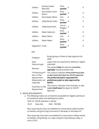
CITY OF GEORGETOWN ORDINANCE NO. 2003-24 
AN ORDINANCE RELATED TO THE AMENDMENT OF THE GEORGETOWN/SCOTT 
COUNTY SUBDIVISION & DEVELOPMENT REGULATIONS REGARDING ARTICLE V & 
VII – SPECIFICATIONS FOR DIGITAL SUBMITTALS FOR SUBDIVISION PLATS AND 
DEVELOPMENT PLANS & REQUIREMENTS FOR CONTENT AND FORMAT 
WHEREAS: The existing Subdivision & Development Regulations requirements are not 
satisfying the community’s needs. The regulation requirements must be updated to 
reflect the current professional thinking, computerized mapping and best 
management practices to address continuous updates of the Geographic Information 
System. The purpose of these specifications is to form a standardized approach to the 
way a digital drawing submittal is collected, retrieved, stored and analyzed, affording 
the Georgetown-Scott County Planning Commission office the ability to share data 
among multiple agencies and to reduce redundancy. This new requirement will allow 
the Geographic Information System (GIS) to be as current as possible, making the 
information more valuable to all the agencies involved. 
WHEREAS: The Georgetown -Scott County Planning Commission (GSCPC) will require 
subdivision plats and development plans to be submitted in digital format upon 
adoption and publication. This requirement will call for delivery of the digital 
submittal at the final recording of the plat and certification of the plan. This 
requirement is in addition to the existing requirements outlined in the Subdivision 
and Development Regulations for Georgetown, Sadieville, Stamping Ground, and 
Scott County, Kentucky . 
The intent of a digital submittal requirement is to enable the required hard copy and 
the digital submission to be produced from the same digital data without any 
modification by the firms submitting the data or the GSCPC staff. The digital submittal 
is not required to have engineering notes or engineering stamp/certification per 201 
KAR 18:102 as it relates to KRS 322.340. 
A basis of structure is required, such as layer elements and the use of the same 
geographic/geodetic base by the firms and GSCPC. However, there are no database 
linkage requirements. The digital submittal structure requirements are subject to 
change. 
The hard copy will continue to be the official document. 
The intent of this proposed ordinance is to provide an appropriate means to maintain 
the integrity and accuracy of the existing computerized database and base mapping 
within the Geographic Information System. 
WHEREAS: This proposed amendment to the Georgetown-Scott County Subdivision & 
Development Regulations has been submitted to the citizens through a properly 
advertised public hearing before the Georgetown-Scott County Planning and Zoning 
Commission conducted at their August 8, 2002, and September 12, 2002, public 
meeting and re-reviewed at the Commission’s July 10, 2003, public meeting. The
Commission voted unanimously to recommend the adoption of this amendment to 
the City Council of Georgetown; 
NOW, THEREFORE, BE IT ORDAINED BY THE COUNCIL FOR THE CITY OF 
GEORGETOWN, KENTUCKY, as follows: 
SECTION ONE: NEW PROVISIONS. 
[New language is bold. Language which is unchanged is not marked. Superseded 
language is shown as stricken.] 
1. A-E: unchanged 
F: unchanged 
1. unchanged 
2. unchanged 
3. unchanged 
4. unchanged 
5. unchanged 
6. Location and type of existing and new monuments and pins, which 
shall be placed at the intersection of property lines, the intersection 
of property lines, the intersection of street center lines, changes in 
street direction, and the intersections and angles of the development 
boundary. 
Note: All survey information shall be to the “Minimum Standards of Practice for Land Surveying In Kentucky ” 
7. Requested Information (not required) 
a. Digital Submittals of Plans and Plats in accordance with 
Article VII – Section 720 
2. THE SUBDIVISION & DEVELOPMENT REGULATIONS, ARTICLE VII, is amended to 
include : 
[New language is bold. Language which is unchanged is not marked. Superseded language is shown as stricken.] 
SECTION 720 
CONTENT & FORMAT REQUIREMENTS FOR SUBDIVISION PLATS AND 
DEVELOPMENT PLANS IN DIGITAL FORM 
1. PURPOSE: 
The purpose is to describe the minimum content and format of digital files 
of subdivision plats and development plans before they are officially filed. 
This requirement does not include minor plats and/or boundary line 
adjustments. 
Submittals of preliminary and construction plans for the subdivision plat or 
development plan are an optional delivery (requested), but not required. 
This document applies to subdivision plats and development plans that are 
being officially filed.
2. SUPPORTED CAD DRAWING FILE FORMATS 
MicroStation® stores its drawing in a design file format with the .DGN 
extension. The GSCPC will accept files generated by MicroStation® up to 
Release MJ. 
AutoCADâ stores its drawing in a proprietary drawing file format with the 
.DWG extension. The GSCPC will accept files generated by AutoCAD® 
Release 14 and higher. 
In addition to .DWG files, AutoCAD® supports DXF (Drawing Interchange 
file) format, an industry standard interchange file format used to transfer 
data between CAD and GIS applications. However, when using this format 
the information put into the drawing may not completely transfer as it was 
drawn. The GSCPC will accept files generated by AutoCAD® DXF. 
The preferred format for digital submissions to the GIS office will be .DWG. 
The GSCPC may waive or adjust this requirement as specified herein. 
File names will be eight or more characters, alpha-numeric, followed by the 
drawing software's extension. 
The GIS softwares, ArcInfo and ArcView, can read the .DGN, .DWG, and 
.DXF file formats. 
3. DATA LAYERING & SUBMISSION REQUIREMENTS 
1. Data Feature/Layer Requirement: 
1. Parcel Line – required to be snapped at common/shared 
feature. 
2. Buildings – required to be “closed” with closed command as 
performed by AutoCAD or similar software. 
2. Annotation Requirement: Annotation submitted digitally will be 
identical to annotation submitted on the hard copy maps. The 
section on Data Layering Requirements defines requirements for 
submission of annotation. 
3. Coordinates Displayed as Text Requirement: When displaying x 
and y (and z) coordinates, the whole number for the coordinate 
will be shown to two (2) decimal positions, i.e., no constants will 
be applied. 
4. The layer names must be identifiable by another person. For 
example, layer names created like the following are acceptable 
mon_pnt, lot_num, drng_area, ex_row, san_lin, swr_txt, wtr_lin. 
5. Each layer must have only its element on it. For example, a water line 
must be on a water line layer versus the stormwater line or right-of-way 
line layers. In addition, with Microstation®, each layer number 
needs to have a layer name associated with it. Or with other CAD 
software, the layer names must be identifiable like mon_pnt, lot_num, 
drng_area, ex_row, san_lin, swr_txt, wtr_lin. 
6. All External reference files (xref) must be "bound" into the .DWG CAD 
file prior to submittal or included with the submittal.
7. Public domain and custom AutoCAD® (.shx) fonts are permitted in 
the drawing files only if the latest copies of each of these fonts are 
provided to the Georgetown-Scott County Planning Commission with 
the submittal of the .DWG file. 
8. Text for any layer will be on its own layer. The layer name is 
requested to end in "txt." 
9. The following table displays the data features, elements and 
requirements needed REQUIRED in a digital submittal. Additional 
layers are encouraged. 
Category Data Feature/Layer Element 
**Preliminary** 
Plan or Plat 
Requirements 
Final Plan or 
Plat 
Requirements 
Basic Address Numbers Text X X 
Basic Bearings Text X X 
Basic Street Names Text X X 
Basic Structure (Buildings) 
Line, 
Polygon 
X X 
Boundary 
City Limits 
(Annexations) 
Line or 
Polygon 
X X 
Monument 
Monument (Control 
and others) 
Point 
symbol 
X X 
Monument 
Monument 
Description (x,y,z) 
Text X X 
Parcel Boundary/Lot Lines Line X X 
Parcel 
Building Set Back 
Line 
Line X X 
Parcel Lot Numbers Text X X 
Parcel 
Starting Point of 
Legal Description 
Text X X 
Street Centerline Line X X 
Street Curb Line Line X X 
Street Right of Way Line X X 
Street 
Street Name 
(proposed to, 
accepted by GSCPC) 
Text X X 
Utilities Drainage Area Polygon X X 
Utilities Drainage Easements 
Line or 
Polygon 
X X 
Utilities 
Drainage Basins 
(retention/detention) 
Polygon X X 
Utilities Existing Easements Line X X 
Utilities Sanitary Easements 
Line or 
Polygon 
X X 
Utilities Sanitary Sewer Main Line X X
Utilities 
Sanitary Sewer 
Manhole 
Point 
symbol 
X X 
Utilities 
Stormwater Catch 
Basins 
Point 
symbol 
X X 
Utilities Stormwater Mains Line X X 
Utilities Utility/Street Poles 
Point 
symbol 
X X 
Utilities Utility Easements 
Line or 
Polygon 
X X 
Utilities Water Hydrants 
Point 
symbol 
X X 
Utilities Water Mains Line X X 
Utilities Water Meter 
Point 
symbol 
X X 
Vegetation Trees 
Point 
symbol 
X X 
Key: 
Category 
Broad groups of data to help organize this 
table 
Data 
Feature/Layer 
Layers that are required for delivery in digital 
submittal 
Element 
The symbol that the element should be 
typically should be drawn with. 
**Preliminary** 
Plan or Plat 
Requirement 
(Requested, not 
required) 
This column indicates if the preliminary plan 
or plat needs this layer for GSCPC approval 
the preferred layers requested for 
preliminary plan or plat approval by 
GSCPC. 
Final Plan or Plat 
Requirement 
This column indicates if the final plan or plat 
needs shall have this layer for GSCPC 
approval. 
4. MEDIA REQUIREMENTS 
a. The following media are considered acceptable for digital submission 
of subdivision plats and development plans. 
DOS 3.5" DSHD diskettes (1.44mb) 
CD-R Data disk (650 - 700 MB) 
Files requiring less than one diskette for transmission will be written 
to diskette using the Copy Command in Windows or Windows NT. 
Files requiring more than one diskette for transmission will be written 
to diskette using WinZip, to a tape using the Tape Backup utility, or 
onto a CD-R.
The software name and version used to create the copied data will 
appear on the diskette or CD label (see item (b) below.) 
No other files will exist on the media. 
No additional information will exist in the file aside from data being 
specifically transmitted to the GSCPC office. 
b. All media will be submitted with labels indicating the following data 
(see example) and will be signed by the firm's authorized agent 
submitting the map. The purpose of the signature is to verify the 
transmittal of the data, not professional responsibility for the data. It 
is understood by GSCPC that the digital data is not a certified, legal 
document (201 KAR 18:102 as it relates to KRS 322.340). It is the 
responsibility of the GSCPC staff to refer to the recorded map for the 
corrected information. 
Example: 
Project or Subdivision Name: Big Tree Acres 
File Name: bigtreacrs.dwg 
Date: July 1, 1998 
Company Name: Jones & Associates, Inc. 
LS / PE: John Doe 
Reg. No.: L.S. 7801 
Format: DWG/DXF/DOS/4 Backup 
Signature: John Doe 
c. The media delivered to GSCPC can be returned upon request. 
d. MEDIA SUBMISSION TIMELINE 
The digital file must be submitted at the time the GSCPC certifies the 
plat/plan for recording in the County Clerk's Office. 
5. CONVENTIONAL HARD COPY SUBMISSION REQUIREMENTS 
The following requirements pertain to hard copy maps that are submitted 
in conjunction with a digital submittal. In order to facilitate the map 
checking process and to enable direct correlation between the hard copy 
map and the digital submission, the following points should be noted. 
Any distance, on or internal to, the boundary of the map must meet 
National Map Accuracy Standards. 
The following convention for symbolization of monumentation is the 
preferred and recommended convention. Three monument symbols 
will be used. 
Control points - represented by a solid triangle 
Found monuments - represented by a solid circle
Set Monuments - represented by a solid square 
A control or set monument description (x, y, and z) will be called out 
separately as required by the Kentucky State Plane Coordinate 
System North Zone NAD 1983 in U.S. survey feet (see also Section 
7.b.) 
6. DATA INTEGRITY REQUIREMENTS 
The following requirements pertain to the mathematical integrity of the 
geometric data. 
REQUIRED STANDARD: The requirement is to follow the 201 KAR 
18.150 "The Standards of Practice for Professional Land Surveyors," 
Section 7, Measurement Specifications, (6) Table of Specifications by 
Class: Classification of Surveys, or current edition (latest). 
RECOMMENDED STANDARDS: 
a. The maximum error allowable between theoretically coincident 
points will be 9 mm (.03 feet). 
b. The maximum error allowable between points on line and the 
line will be 6 mm (.02 feet). 
c. The difference between distances calculated by inverting 
between the coordinates of points in the digital submission and 
the annotated distances shall not exceed 3 mm (.01 feet). 
d. The difference in seconds between bearings calculated by 
inverting between the coordinates of points in the digital 
submission and the annotated bearings shall not exceed the 
maximum of (1031/dist (ft), 1"). 
Examples: 
Distance Allowable Error in Bearing (seconds) 
50 21 
100 11 
200 6 
1200 1 
5000 1 
e. Boundaries will be transmitted as closed figure. For example in 
a DWG file, a boundary would be represented as one polyline 
such as series of lines, rather than arcs and curves, then closed 
using the "close" command. 
f. Annotation submitted digitally will be identical to annotation 
submitted on the hard copy maps. The section on Data Layering 
Requirements defines requirements for submission of 
annotation. 
g. When displaying x and y (and z) coordinates, the whole number 
for the coordinate will be shown to two (2) decimal positions, 
i.e., no constants will be applied.
7. TIES TO HORIZONTAL CONTROL 
GSCPC will provide a DWG file of the control monument locations and 
point identification text. A control monument book of the monuments 
located in Scott County is available for viewing in the GSCPC office. These 
monuments use the horizontal datum NAD83 and vertical datum 1929 
unless otherwise noted. 
a. The surveyor or engineer will be required to reference horizontal 
control monuments in accordance with the Subdivision and 
Development Regulations. Coordinates for these control monuments 
shall be shown on the digital file as required by the Data Layering and 
Submission Requirements section of this document. 
1. In areas where the minimum control monuments are not 
available, the use of two (2) boundary monuments located in 
opposite sides of the plan/plat can be referenced for horizontal 
control and x/y position. 
2. Upon review with the surveyor/engineer, GSCPC may waive this 
requirement. 
b. The boundary of the submitted plan shall be tied into the Kentucky 
State Plane Coordinate System North Zone NAD 1983 in U.S. survey 
feet in at least two (2) locations or on opposite sides of the 
subdivision boundary as agreed upon by GSCPC staff. 
c. The basis of bearings of the plat shall be the Kentucky State Plane 
Coordinate System North Zone NAD 1983 in U.S. survey feet, or latest 
revision of adjustment in at least two locations, preferably on 
opposite sides of the subdivision boundary as mutually agreed upon 
by the GSCPC staff. 
d. If the boundary of the development is a parcel or lot of a plat already 
tied to the Kentucky State Plane Coordinate System North Zone NAD 
1983, the requirements of paragraph (c) shall be waived with the 
stipulation that the surveyor or engineer be required to show existing 
monumentation and coordinates on the plan/plat. 
8. CHECKING OF DIGITAL DATA 
a. The digital data will be checked for the following criteria: 
i. Identifiable layer names 
ii. Closure or the geometry of the boundary features in the 
submittal 
iii. Verification that digital and hard copy maps are consistent 
iv. Correct geographic /geodetic position, i.e. correct coordinate 
system 
b. The developer will be given ten (10) working days from the day of 
notification of errors to correct and resubmit the corrected digital file. 
Once the digital data is corrected, resubmitted, and verified to be in 
accordance with the "Specifications for Digital Submittals and 
Requirements for Content and Format" document through the GSCPC's GIS 
Office, GSCPC staff will be issued a copy of the plat generated by the digital
submittal. GSCPC staff will check it against the hard copy received to verify 
they coincide, and then proceed with the process of ensuring the 
information complies with the Subdivision and Development Regulations for 
Georgetown , Sadieville, Stamping Ground, and Scott County, Kentucky and 
make a recommendation to the Planning Commission 
9. ADJUSTMENTS TO THESE REQUIREMENTS 
a. The Georgetown-Scott County Planning Commission may waive or 
adjust requirements specified herein, upon a finding that the strict 
adherence of the requirements does not apply or is contrary to the 
long-term maintenance of the GIS of Georgetown and Scott County. 
b. The GSCPC staff may upon review of the subdivision or development 
require submittal of the 'as-built' in accordance with these 
regulations based on minor or major amendments. 
c. Nine months from date of adoption, GSCPC staff will perform an 
audit of these requirements to monitor compliance and overall 
effectiveness and make amendments as needed. 
SECTION TWO: EFFECTIVE DATE: 
This Ordinance shall take effect upon passage and publication. 
The original ordinance was introduced and read for the first time at the Council’s 
regular meeting October 1, 2002, and for the second time, adopted and approved, at 
the Council’s regular meeting October 17, 2002 . 
The foregoing Ordinance was introduced and read for the first time at the Council’s 
regular meeting August 7, 2003, and for the second time, adopted and approved, at 
the Council’s regular meeting August 21, 2003. 
APPROVED BY: EVERETTE VARNEY, MAYOR 
ATTESTED BY: SUE LEWIS, CLERK

Digital submittal

  • 1.
    CITY OF GEORGETOWNORDINANCE NO. 2003-24 AN ORDINANCE RELATED TO THE AMENDMENT OF THE GEORGETOWN/SCOTT COUNTY SUBDIVISION & DEVELOPMENT REGULATIONS REGARDING ARTICLE V & VII – SPECIFICATIONS FOR DIGITAL SUBMITTALS FOR SUBDIVISION PLATS AND DEVELOPMENT PLANS & REQUIREMENTS FOR CONTENT AND FORMAT WHEREAS: The existing Subdivision & Development Regulations requirements are not satisfying the community’s needs. The regulation requirements must be updated to reflect the current professional thinking, computerized mapping and best management practices to address continuous updates of the Geographic Information System. The purpose of these specifications is to form a standardized approach to the way a digital drawing submittal is collected, retrieved, stored and analyzed, affording the Georgetown-Scott County Planning Commission office the ability to share data among multiple agencies and to reduce redundancy. This new requirement will allow the Geographic Information System (GIS) to be as current as possible, making the information more valuable to all the agencies involved. WHEREAS: The Georgetown -Scott County Planning Commission (GSCPC) will require subdivision plats and development plans to be submitted in digital format upon adoption and publication. This requirement will call for delivery of the digital submittal at the final recording of the plat and certification of the plan. This requirement is in addition to the existing requirements outlined in the Subdivision and Development Regulations for Georgetown, Sadieville, Stamping Ground, and Scott County, Kentucky . The intent of a digital submittal requirement is to enable the required hard copy and the digital submission to be produced from the same digital data without any modification by the firms submitting the data or the GSCPC staff. The digital submittal is not required to have engineering notes or engineering stamp/certification per 201 KAR 18:102 as it relates to KRS 322.340. A basis of structure is required, such as layer elements and the use of the same geographic/geodetic base by the firms and GSCPC. However, there are no database linkage requirements. The digital submittal structure requirements are subject to change. The hard copy will continue to be the official document. The intent of this proposed ordinance is to provide an appropriate means to maintain the integrity and accuracy of the existing computerized database and base mapping within the Geographic Information System. WHEREAS: This proposed amendment to the Georgetown-Scott County Subdivision & Development Regulations has been submitted to the citizens through a properly advertised public hearing before the Georgetown-Scott County Planning and Zoning Commission conducted at their August 8, 2002, and September 12, 2002, public meeting and re-reviewed at the Commission’s July 10, 2003, public meeting. The
  • 2.
    Commission voted unanimouslyto recommend the adoption of this amendment to the City Council of Georgetown; NOW, THEREFORE, BE IT ORDAINED BY THE COUNCIL FOR THE CITY OF GEORGETOWN, KENTUCKY, as follows: SECTION ONE: NEW PROVISIONS. [New language is bold. Language which is unchanged is not marked. Superseded language is shown as stricken.] 1. A-E: unchanged F: unchanged 1. unchanged 2. unchanged 3. unchanged 4. unchanged 5. unchanged 6. Location and type of existing and new monuments and pins, which shall be placed at the intersection of property lines, the intersection of property lines, the intersection of street center lines, changes in street direction, and the intersections and angles of the development boundary. Note: All survey information shall be to the “Minimum Standards of Practice for Land Surveying In Kentucky ” 7. Requested Information (not required) a. Digital Submittals of Plans and Plats in accordance with Article VII – Section 720 2. THE SUBDIVISION & DEVELOPMENT REGULATIONS, ARTICLE VII, is amended to include : [New language is bold. Language which is unchanged is not marked. Superseded language is shown as stricken.] SECTION 720 CONTENT & FORMAT REQUIREMENTS FOR SUBDIVISION PLATS AND DEVELOPMENT PLANS IN DIGITAL FORM 1. PURPOSE: The purpose is to describe the minimum content and format of digital files of subdivision plats and development plans before they are officially filed. This requirement does not include minor plats and/or boundary line adjustments. Submittals of preliminary and construction plans for the subdivision plat or development plan are an optional delivery (requested), but not required. This document applies to subdivision plats and development plans that are being officially filed.
  • 3.
    2. SUPPORTED CADDRAWING FILE FORMATS MicroStation® stores its drawing in a design file format with the .DGN extension. The GSCPC will accept files generated by MicroStation® up to Release MJ. AutoCADâ stores its drawing in a proprietary drawing file format with the .DWG extension. The GSCPC will accept files generated by AutoCAD® Release 14 and higher. In addition to .DWG files, AutoCAD® supports DXF (Drawing Interchange file) format, an industry standard interchange file format used to transfer data between CAD and GIS applications. However, when using this format the information put into the drawing may not completely transfer as it was drawn. The GSCPC will accept files generated by AutoCAD® DXF. The preferred format for digital submissions to the GIS office will be .DWG. The GSCPC may waive or adjust this requirement as specified herein. File names will be eight or more characters, alpha-numeric, followed by the drawing software's extension. The GIS softwares, ArcInfo and ArcView, can read the .DGN, .DWG, and .DXF file formats. 3. DATA LAYERING & SUBMISSION REQUIREMENTS 1. Data Feature/Layer Requirement: 1. Parcel Line – required to be snapped at common/shared feature. 2. Buildings – required to be “closed” with closed command as performed by AutoCAD or similar software. 2. Annotation Requirement: Annotation submitted digitally will be identical to annotation submitted on the hard copy maps. The section on Data Layering Requirements defines requirements for submission of annotation. 3. Coordinates Displayed as Text Requirement: When displaying x and y (and z) coordinates, the whole number for the coordinate will be shown to two (2) decimal positions, i.e., no constants will be applied. 4. The layer names must be identifiable by another person. For example, layer names created like the following are acceptable mon_pnt, lot_num, drng_area, ex_row, san_lin, swr_txt, wtr_lin. 5. Each layer must have only its element on it. For example, a water line must be on a water line layer versus the stormwater line or right-of-way line layers. In addition, with Microstation®, each layer number needs to have a layer name associated with it. Or with other CAD software, the layer names must be identifiable like mon_pnt, lot_num, drng_area, ex_row, san_lin, swr_txt, wtr_lin. 6. All External reference files (xref) must be "bound" into the .DWG CAD file prior to submittal or included with the submittal.
  • 4.
    7. Public domainand custom AutoCAD® (.shx) fonts are permitted in the drawing files only if the latest copies of each of these fonts are provided to the Georgetown-Scott County Planning Commission with the submittal of the .DWG file. 8. Text for any layer will be on its own layer. The layer name is requested to end in "txt." 9. The following table displays the data features, elements and requirements needed REQUIRED in a digital submittal. Additional layers are encouraged. Category Data Feature/Layer Element **Preliminary** Plan or Plat Requirements Final Plan or Plat Requirements Basic Address Numbers Text X X Basic Bearings Text X X Basic Street Names Text X X Basic Structure (Buildings) Line, Polygon X X Boundary City Limits (Annexations) Line or Polygon X X Monument Monument (Control and others) Point symbol X X Monument Monument Description (x,y,z) Text X X Parcel Boundary/Lot Lines Line X X Parcel Building Set Back Line Line X X Parcel Lot Numbers Text X X Parcel Starting Point of Legal Description Text X X Street Centerline Line X X Street Curb Line Line X X Street Right of Way Line X X Street Street Name (proposed to, accepted by GSCPC) Text X X Utilities Drainage Area Polygon X X Utilities Drainage Easements Line or Polygon X X Utilities Drainage Basins (retention/detention) Polygon X X Utilities Existing Easements Line X X Utilities Sanitary Easements Line or Polygon X X Utilities Sanitary Sewer Main Line X X
  • 5.
    Utilities Sanitary Sewer Manhole Point symbol X X Utilities Stormwater Catch Basins Point symbol X X Utilities Stormwater Mains Line X X Utilities Utility/Street Poles Point symbol X X Utilities Utility Easements Line or Polygon X X Utilities Water Hydrants Point symbol X X Utilities Water Mains Line X X Utilities Water Meter Point symbol X X Vegetation Trees Point symbol X X Key: Category Broad groups of data to help organize this table Data Feature/Layer Layers that are required for delivery in digital submittal Element The symbol that the element should be typically should be drawn with. **Preliminary** Plan or Plat Requirement (Requested, not required) This column indicates if the preliminary plan or plat needs this layer for GSCPC approval the preferred layers requested for preliminary plan or plat approval by GSCPC. Final Plan or Plat Requirement This column indicates if the final plan or plat needs shall have this layer for GSCPC approval. 4. MEDIA REQUIREMENTS a. The following media are considered acceptable for digital submission of subdivision plats and development plans. DOS 3.5" DSHD diskettes (1.44mb) CD-R Data disk (650 - 700 MB) Files requiring less than one diskette for transmission will be written to diskette using the Copy Command in Windows or Windows NT. Files requiring more than one diskette for transmission will be written to diskette using WinZip, to a tape using the Tape Backup utility, or onto a CD-R.
  • 6.
    The software nameand version used to create the copied data will appear on the diskette or CD label (see item (b) below.) No other files will exist on the media. No additional information will exist in the file aside from data being specifically transmitted to the GSCPC office. b. All media will be submitted with labels indicating the following data (see example) and will be signed by the firm's authorized agent submitting the map. The purpose of the signature is to verify the transmittal of the data, not professional responsibility for the data. It is understood by GSCPC that the digital data is not a certified, legal document (201 KAR 18:102 as it relates to KRS 322.340). It is the responsibility of the GSCPC staff to refer to the recorded map for the corrected information. Example: Project or Subdivision Name: Big Tree Acres File Name: bigtreacrs.dwg Date: July 1, 1998 Company Name: Jones & Associates, Inc. LS / PE: John Doe Reg. No.: L.S. 7801 Format: DWG/DXF/DOS/4 Backup Signature: John Doe c. The media delivered to GSCPC can be returned upon request. d. MEDIA SUBMISSION TIMELINE The digital file must be submitted at the time the GSCPC certifies the plat/plan for recording in the County Clerk's Office. 5. CONVENTIONAL HARD COPY SUBMISSION REQUIREMENTS The following requirements pertain to hard copy maps that are submitted in conjunction with a digital submittal. In order to facilitate the map checking process and to enable direct correlation between the hard copy map and the digital submission, the following points should be noted. Any distance, on or internal to, the boundary of the map must meet National Map Accuracy Standards. The following convention for symbolization of monumentation is the preferred and recommended convention. Three monument symbols will be used. Control points - represented by a solid triangle Found monuments - represented by a solid circle
  • 7.
    Set Monuments -represented by a solid square A control or set monument description (x, y, and z) will be called out separately as required by the Kentucky State Plane Coordinate System North Zone NAD 1983 in U.S. survey feet (see also Section 7.b.) 6. DATA INTEGRITY REQUIREMENTS The following requirements pertain to the mathematical integrity of the geometric data. REQUIRED STANDARD: The requirement is to follow the 201 KAR 18.150 "The Standards of Practice for Professional Land Surveyors," Section 7, Measurement Specifications, (6) Table of Specifications by Class: Classification of Surveys, or current edition (latest). RECOMMENDED STANDARDS: a. The maximum error allowable between theoretically coincident points will be 9 mm (.03 feet). b. The maximum error allowable between points on line and the line will be 6 mm (.02 feet). c. The difference between distances calculated by inverting between the coordinates of points in the digital submission and the annotated distances shall not exceed 3 mm (.01 feet). d. The difference in seconds between bearings calculated by inverting between the coordinates of points in the digital submission and the annotated bearings shall not exceed the maximum of (1031/dist (ft), 1"). Examples: Distance Allowable Error in Bearing (seconds) 50 21 100 11 200 6 1200 1 5000 1 e. Boundaries will be transmitted as closed figure. For example in a DWG file, a boundary would be represented as one polyline such as series of lines, rather than arcs and curves, then closed using the "close" command. f. Annotation submitted digitally will be identical to annotation submitted on the hard copy maps. The section on Data Layering Requirements defines requirements for submission of annotation. g. When displaying x and y (and z) coordinates, the whole number for the coordinate will be shown to two (2) decimal positions, i.e., no constants will be applied.
  • 8.
    7. TIES TOHORIZONTAL CONTROL GSCPC will provide a DWG file of the control monument locations and point identification text. A control monument book of the monuments located in Scott County is available for viewing in the GSCPC office. These monuments use the horizontal datum NAD83 and vertical datum 1929 unless otherwise noted. a. The surveyor or engineer will be required to reference horizontal control monuments in accordance with the Subdivision and Development Regulations. Coordinates for these control monuments shall be shown on the digital file as required by the Data Layering and Submission Requirements section of this document. 1. In areas where the minimum control monuments are not available, the use of two (2) boundary monuments located in opposite sides of the plan/plat can be referenced for horizontal control and x/y position. 2. Upon review with the surveyor/engineer, GSCPC may waive this requirement. b. The boundary of the submitted plan shall be tied into the Kentucky State Plane Coordinate System North Zone NAD 1983 in U.S. survey feet in at least two (2) locations or on opposite sides of the subdivision boundary as agreed upon by GSCPC staff. c. The basis of bearings of the plat shall be the Kentucky State Plane Coordinate System North Zone NAD 1983 in U.S. survey feet, or latest revision of adjustment in at least two locations, preferably on opposite sides of the subdivision boundary as mutually agreed upon by the GSCPC staff. d. If the boundary of the development is a parcel or lot of a plat already tied to the Kentucky State Plane Coordinate System North Zone NAD 1983, the requirements of paragraph (c) shall be waived with the stipulation that the surveyor or engineer be required to show existing monumentation and coordinates on the plan/plat. 8. CHECKING OF DIGITAL DATA a. The digital data will be checked for the following criteria: i. Identifiable layer names ii. Closure or the geometry of the boundary features in the submittal iii. Verification that digital and hard copy maps are consistent iv. Correct geographic /geodetic position, i.e. correct coordinate system b. The developer will be given ten (10) working days from the day of notification of errors to correct and resubmit the corrected digital file. Once the digital data is corrected, resubmitted, and verified to be in accordance with the "Specifications for Digital Submittals and Requirements for Content and Format" document through the GSCPC's GIS Office, GSCPC staff will be issued a copy of the plat generated by the digital
  • 9.
    submittal. GSCPC staffwill check it against the hard copy received to verify they coincide, and then proceed with the process of ensuring the information complies with the Subdivision and Development Regulations for Georgetown , Sadieville, Stamping Ground, and Scott County, Kentucky and make a recommendation to the Planning Commission 9. ADJUSTMENTS TO THESE REQUIREMENTS a. The Georgetown-Scott County Planning Commission may waive or adjust requirements specified herein, upon a finding that the strict adherence of the requirements does not apply or is contrary to the long-term maintenance of the GIS of Georgetown and Scott County. b. The GSCPC staff may upon review of the subdivision or development require submittal of the 'as-built' in accordance with these regulations based on minor or major amendments. c. Nine months from date of adoption, GSCPC staff will perform an audit of these requirements to monitor compliance and overall effectiveness and make amendments as needed. SECTION TWO: EFFECTIVE DATE: This Ordinance shall take effect upon passage and publication. The original ordinance was introduced and read for the first time at the Council’s regular meeting October 1, 2002, and for the second time, adopted and approved, at the Council’s regular meeting October 17, 2002 . The foregoing Ordinance was introduced and read for the first time at the Council’s regular meeting August 7, 2003, and for the second time, adopted and approved, at the Council’s regular meeting August 21, 2003. APPROVED BY: EVERETTE VARNEY, MAYOR ATTESTED BY: SUE LEWIS, CLERK