Creating Maps of Wakefield Using Local Studies
•
3 likes•502 views

The document summarizes a lesson where Year 5 students in Wakefield, England created maps of their local area using drawing and symbol tools. Some key points: - Students created maps of places within Wakefield like routes to school, parks, shops and landmarks. The maps ranged in complexity and accuracy. - The activity showed the students' spatial awareness and understanding of their local area. It demonstrated what they had learned previously. - Next steps discussed were completing the maps, adding photos and details, and comparing the student-created maps to printed maps to discuss purposes and conventions.
Report
Share
Report
Share
![Week 5 – Meeting again! ,[object Object],[object Object]](data:image/gif;base64,R0lGODlhAQABAIAAAAAAAP///yH5BAEAAAAALAAAAAABAAEAAAIBRAA7)
Recommended
Student Voice Survey - Feb08
The document summarizes the results of a geography student voice questionnaire collected from Dr Thomlinson Middle School in Rothbury. Students indicated that they enjoyed drawing and labeling maps, going on field trips, and learning about different places. They wanted more map work, field trips, fun games, practical work, posters, internet use, and information about the environment. Students wanted less map work, less time sitting and working from textbooks, and less written work. To improve the geography student voice board, students suggested displaying student work, using more colorful maps, and providing more interesting facts and information about what each year is studying.
Exminster community primary school bronze award ppt
Exminster Community Primary School received a Bronze Award for Primary Geography Quality Mark in 2014. Geography at the school is inspiring, inclusive, global, creative, cross-curricular, and pupil-led. It focuses on developing pupils' knowledge of places, map skills, fieldwork, and appreciation of global issues. Teachers use a variety of teaching methods including projects, discussions, visits, and pupil voice to make learning engaging. The school aims to promote high achievement, skills progression, and positive attitudes in geography for all pupils.
The Primary Geography Quality Mark - Leading the Way
The Primary Geography Quality Mark (PGQM) was developed by the Geographical Association to recognize and improve the quality of primary geography education. The PGQM framework provides a self-assessment tool to help schools evaluate their geography curriculum, identify strengths and weaknesses, and develop areas that need improvement. Schools can apply for one of three levels of the PGQM based on the extent geography is embedded within the school. The PGQM aims to enhance student learning and engagement with geography, as well as support subject leadership.
Travels in the ACT, Australia 2008
1. The document summarizes a nature walk through a reserve near Canberra, Australia where the author spots various wildlife.
2. They observe echidnas and birds like the Crimson Rosella.
3. The walk concludes with the observation that a new housing development is being built near the reserve, raising questions about protecting the wildlife.
Living Geography
The introductory PowerPoint used on the first session of the Young Geographers project in Sheffield, 18th January 2008
Travels In Australia Day 2: We visit the Reptile Park
We spend a day at the Reptile Park which is just outside Gosford on the Central Coast of NSW, Australia
PGQM - Leading the way
The document discusses the Primary Geography Quality Mark (PGQM), which is a framework used by schools in the UK to evaluate and improve their geography curriculum. It provides examples of how schools have used the PGQM to highlight effective geography teaching, raise the profile of geography, and develop their curriculum. The PGQM self-assessment framework guides schools through an auditing process to identify strengths and areas for growth in their geography program.
Leading the way in Primary Geography
This document provides an overview of a seminar focused on supporting subject leadership in primary geography. It introduces the Primary Geography Quality Mark (PGQM) as a tool for developing, evaluating, and gaining recognition for geography curriculum quality. Key areas that underpin effective subject leadership are discussed using examples from PGQM schools. The seminar focuses on developing a vision for geography and recognizing geographical achievement. Effective geography curriculum is described as living geography that enhances students' understanding of their identity, community, and world.
Creating Maps with Local Studies
Mapping our feelings about places using the software programme Local Studies and the internet mapping software Quikmaps.
Mapping Our Worlds
This document outlines an activity to teach students about maps and mapping the world. It begins by defining what maps and globes are, then provides background on the history of maps in America. Students are divided into groups to examine different types of maps and notice their features. They also draw their own "mental maps" of familiar places. Next, students work together to map their classroom. Finally, the activity shows students how their classroom map relates to larger maps by zooming out from a map of their school to city, state, country, and world maps to demonstrate the relationship between different scales of maps.
Chapter 11Exploring Our Geographic World
Chapter 11
Exploring Our Geographic World
*
DistanceTime and distance are very important concepts in the social studies curriculum.Children’s sense of time develops gradually.Maps and globes help children understand distance, direction, and location.
*
MapsMaps show portions of the earth, which is a sphere, on a flat surface.Maps must compromise size, distance, and proportion.Maps are abstract representations of reality.Maps do not show everything, but only what is important to a researcher.Maps are resources used to communicate reality in a selective way.
*
Experiential Approaches to TeachingTraditional textbook approaches are less effective than experiential approaches.Hands on experiences are very important for young children to make connections between the landscape and its graphic representation.Children begin making maps at a very young age when they draw pictures.
*
The Five Themes of GeographyThe five themes of geography can provide points of reference for activities related to geography and include:
Location
Place
Interaction
Movement
Region
*
Location & PlaceTeachers can introduce the concept of location by discussing absolute location.The absolute location is at a particular intersect of longitude and latitude or the address that locates a place within a city or town.Relative location involves how near or far a place is to other places.A place has certain characteristics such as whether it is cold, dry, humid, flat or hilly.
*
Interaction, Movement & RegionThe concept of interaction focuses on the way people change and use their environment.Movement is a concept which explains the way people move from location to location. For example, children go to school each morning and leave in the afternoon.A region describes aspects such as suburban, rural, middle class, and so forth.
*
Helping Students Learn to Make and Read MapsStudents need to observe and record in order to make maps.Teachers can help students develop these skills by including a number of activities.An ideal starting point is the school.
*
Mental MapsA mental map refers to images of places in our heads.All of us have been to many places and can also imagine images of places we have never been to.Mental maps are useful because people like to think about places they have been to and places they’ve never visited.Mental maps are not necessarily accurate.
*
Traverse MapsA traverse map represents a line through an area such as a river, street or boundary.Children can make such a map by walking through a block and observing and recording what is on the two sides of the street.When children do observe and record to gather information, they are doing fieldwork.
*
Visualizing SpaceVisualizing space involves the ability to give directions from familiar places such as how to go home from school.Children also tend to enjoy this process and teachers can take advantage of this by offering students activities that allow the ...
Year 3 Geography: Local & Global
Part2: St Catherine’s Catholic Primary School, Sheffield. Developed by Lynne Biggs as part of the Geography and the Global Dimension Project - a joint project run by DECSY and the Geographical Association
1.2.5
This document outlines an activity to teach students about maps and mapping. It begins with definitions of key map terms like map, globe, and atlas. Students are then shown different types of maps like park, museum, and subway maps and asked to identify map elements. Next, students draw their own "mental maps" of familiar places. They then work in groups to map their classroom. Finally, the activity shows students maps at increasing scales from the classroom to Indiana to the US to demonstrate how smaller areas are part of larger maps. The goal is for students to understand the relationships between different types of maps.
Pgqm silver application may 2016
This document summarizes the effectiveness of geography teaching at Appley Bridge All Saints Primary School. It shows that geography has a comprehensive curriculum with clear progression in students' locational knowledge and skills from EYFS to KS2. Fieldwork is emphasized and used to enhance learning. Teaching demonstrates good subject knowledge and engages students through activities such as creating maps and investigating places. Students show enthusiasm for geography and pride in their work.
25 interesting ways_and_tips_to_use_google_ear
This document provides 25 tips for using Google Earth in the classroom, as shared by various educators. Some of the tips include using Google Earth to look at field trip locations before visiting; embedding videos and media into placemarks; using lines and paths to measure distances; slowing down the zoom speed to allow more time to observe details; and overlaying historic maps to see landscape changes over time. The tips cover uses in various subjects from science to literature to history. The document encourages sharing additional tips on how Google Earth can be utilized as an educational tool.
Pgqm final presentation
The document provides examples of how Furneux Pelham School teaches geography effectively across different age groups and in line with their vision for the subject. Fieldwork, active learning, use of ICT, and making connections to other subjects enhance student engagement. Leadership supports geography through curriculum development, staff training, and initiatives like celebrating student achievements in competitions. The school aims to develop students' understanding of people and places locally and globally.
Mission Space Port Ellen Ps Donated By Jo Clark
The document outlines an interdisciplinary space-themed learning project for a primary 4 and 5 composite class. The project aimed to cover science, maths, and literacy outcomes through activities related to space such as creating fact files on planets, investigating day and night cycles, coding animations, and solving real-life space math problems. Students provided feedback saying they enjoyed learning interesting space facts, the science experiments and challenges, and creating animations through cooperative group work.
Social studies lesson plan #1
This lesson plan teaches 5th grade students about landforms in the United States. Students play a review game using latitude and longitude coordinates. They analyze a poem describing landforms and read textbook passages about different regions. Students then create a map labeling various landforms like coastal plains, mountains, and rivers based on what they learned. The teacher monitors student understanding and provides encouragement, with the goal of students being able to correctly identify and illustrate landforms on a map.
Pgqm gold application south farnham school
The document describes the teaching of geography at South Farnham School. It discusses how the school provides a well-planned geography curriculum that gives pupils a good understanding of places around the world. Fieldwork and the use of ICT are emphasized to support pupils' learning. Teachers differentiate instruction and make real-world connections to engage pupils in geography.
Pgqm gold application south farnham school
Children at South Farnham School have a good understanding of geography due to their well-planned curriculum. All year groups have differentiated lessons to ensure all ability levels can access concepts. Fieldwork, map work, critical thinking and ICT are used to support achievement. Pupils enjoy geography and show positive attitudes, which supports progress in learning.
OSM & K-12 Education SotM US 2012 PDX
Presented to the State of the Map US 2012 in Portland, OR. Liberal credits to Aaron Racicot's (@reprojected) GIS Apprenticeship presentation: https://github.com/reprojected/reprojected.github.com/blob/master/presentations/gis_apprentice_2012/GISApprenticeship_final.pdf?raw=true
Unit 8: Comparing Maps
If people once thought you could fall off the edge of the Earth, what did their maps look like?
Compare a selection of maps from different times and places. Afterwards, students will make their own maps. They'll pick a place, think about the level of detail they should include in their map, and think about the different ways the map will portray the things they know about the places shown.
Register to explore the whole course here: https://school.bighistoryproject.com/bhplive?WT.mc_id=Slideshare12202017
Kindergarten Map and Globes Unit
This Kindergarten social studies unit focuses on teaching students about maps and globes. The unit includes 4 activities to help students understand that maps are drawings of places and globes are models of Earth. Students will learn to differentiate land and water features, understand that maps show a view from above, and recognize that maps and globes show things in a smaller size. Assessment includes students creating their own simple maps and discussing what they have learned.
Children and the arts
This document summarizes several art projects done with children in early childhood classrooms. It discusses how the projects incorporated different areas of learning, allowed children to express themselves, and emerged from the children's interests. The projects included illustrating stories, creating a collaborative bicycle out of junk parts, making landscape drawings of the Canadian North, developing shadow puppet plays of northern animals, and designing individual inuksuit sculptures. The document emphasizes giving children ample opportunities to be creative through art and responding to their ideas and questions.
14 interesting ways_to_use_an_google_maps_in_
This document provides 15 tips for using Google Maps in the classroom. Some of the tips include using place pages to provide summaries of locations, adding to a map of outdoor learning opportunities, using distance measurement tools, creating story maps with locations as inspiration, and using maps for research projects by adding placemarks with images and information. The tips showcase many creative ways Google Maps can enhance learning across subjects.
PGQM Silver Ppt application 2013
This document provides information about geography teaching at Audley Primary School. It includes summaries of sections on achievement in geography, assessment, active learning, creativity, knowledge, and cross-curricular links. It also discusses effectiveness of subject leadership and includes examples of medium term geography plans for Years 2 and 3.
Social studies lesson plan #4
The lesson plan aimed to teach 5th grade students about major bodies of water in the United States. Activities included identifying bodies of water on maps, playing an interactive online game, reading from the textbook, and creating a labeled map of their own. The objectives were for students to be able to locate bodies of water on a map, name and describe them, and identify the Continental Divide. Students seemed engaged in the varied activities and most completed the map assignment, though some struggled with specific landforms like the Mississippi River.
Planning Big Ideas
The document provides guidance and ideas for planning geography curriculum units and lessons focused on key geographical concepts. It includes examples of planning frames, outlines for units on various topics, and suggestions for activities and resources to help bring the lessons to life for students in an engaging way through questions, fieldwork, drama, and using artifacts. The overall goal is to help students make real-world connections and develop their understanding of important geography concepts.
Water, water everywhere
A teacher project developed as part of the DfID funded Geography and Global Dimension project run jointly by the Geographical Association and DfID.
Year 3 Geography: Local & Global
Part 1: St Catherine’s Catholic Primary School, Sheffield. Developed by Lynne Biggs as part of the Geography and the Global Dimension Project - a joint project run by DECSY and the Geographical Association
More Related Content
Similar to Creating Maps of Wakefield Using Local Studies
Creating Maps with Local Studies
Mapping our feelings about places using the software programme Local Studies and the internet mapping software Quikmaps.
Mapping Our Worlds
This document outlines an activity to teach students about maps and mapping the world. It begins by defining what maps and globes are, then provides background on the history of maps in America. Students are divided into groups to examine different types of maps and notice their features. They also draw their own "mental maps" of familiar places. Next, students work together to map their classroom. Finally, the activity shows students how their classroom map relates to larger maps by zooming out from a map of their school to city, state, country, and world maps to demonstrate the relationship between different scales of maps.
Chapter 11Exploring Our Geographic World
Chapter 11
Exploring Our Geographic World
*
DistanceTime and distance are very important concepts in the social studies curriculum.Children’s sense of time develops gradually.Maps and globes help children understand distance, direction, and location.
*
MapsMaps show portions of the earth, which is a sphere, on a flat surface.Maps must compromise size, distance, and proportion.Maps are abstract representations of reality.Maps do not show everything, but only what is important to a researcher.Maps are resources used to communicate reality in a selective way.
*
Experiential Approaches to TeachingTraditional textbook approaches are less effective than experiential approaches.Hands on experiences are very important for young children to make connections between the landscape and its graphic representation.Children begin making maps at a very young age when they draw pictures.
*
The Five Themes of GeographyThe five themes of geography can provide points of reference for activities related to geography and include:
Location
Place
Interaction
Movement
Region
*
Location & PlaceTeachers can introduce the concept of location by discussing absolute location.The absolute location is at a particular intersect of longitude and latitude or the address that locates a place within a city or town.Relative location involves how near or far a place is to other places.A place has certain characteristics such as whether it is cold, dry, humid, flat or hilly.
*
Interaction, Movement & RegionThe concept of interaction focuses on the way people change and use their environment.Movement is a concept which explains the way people move from location to location. For example, children go to school each morning and leave in the afternoon.A region describes aspects such as suburban, rural, middle class, and so forth.
*
Helping Students Learn to Make and Read MapsStudents need to observe and record in order to make maps.Teachers can help students develop these skills by including a number of activities.An ideal starting point is the school.
*
Mental MapsA mental map refers to images of places in our heads.All of us have been to many places and can also imagine images of places we have never been to.Mental maps are useful because people like to think about places they have been to and places they’ve never visited.Mental maps are not necessarily accurate.
*
Traverse MapsA traverse map represents a line through an area such as a river, street or boundary.Children can make such a map by walking through a block and observing and recording what is on the two sides of the street.When children do observe and record to gather information, they are doing fieldwork.
*
Visualizing SpaceVisualizing space involves the ability to give directions from familiar places such as how to go home from school.Children also tend to enjoy this process and teachers can take advantage of this by offering students activities that allow the ...
Year 3 Geography: Local & Global
Part2: St Catherine’s Catholic Primary School, Sheffield. Developed by Lynne Biggs as part of the Geography and the Global Dimension Project - a joint project run by DECSY and the Geographical Association
1.2.5
This document outlines an activity to teach students about maps and mapping. It begins with definitions of key map terms like map, globe, and atlas. Students are then shown different types of maps like park, museum, and subway maps and asked to identify map elements. Next, students draw their own "mental maps" of familiar places. They then work in groups to map their classroom. Finally, the activity shows students maps at increasing scales from the classroom to Indiana to the US to demonstrate how smaller areas are part of larger maps. The goal is for students to understand the relationships between different types of maps.
Pgqm silver application may 2016
This document summarizes the effectiveness of geography teaching at Appley Bridge All Saints Primary School. It shows that geography has a comprehensive curriculum with clear progression in students' locational knowledge and skills from EYFS to KS2. Fieldwork is emphasized and used to enhance learning. Teaching demonstrates good subject knowledge and engages students through activities such as creating maps and investigating places. Students show enthusiasm for geography and pride in their work.
25 interesting ways_and_tips_to_use_google_ear
This document provides 25 tips for using Google Earth in the classroom, as shared by various educators. Some of the tips include using Google Earth to look at field trip locations before visiting; embedding videos and media into placemarks; using lines and paths to measure distances; slowing down the zoom speed to allow more time to observe details; and overlaying historic maps to see landscape changes over time. The tips cover uses in various subjects from science to literature to history. The document encourages sharing additional tips on how Google Earth can be utilized as an educational tool.
Pgqm final presentation
The document provides examples of how Furneux Pelham School teaches geography effectively across different age groups and in line with their vision for the subject. Fieldwork, active learning, use of ICT, and making connections to other subjects enhance student engagement. Leadership supports geography through curriculum development, staff training, and initiatives like celebrating student achievements in competitions. The school aims to develop students' understanding of people and places locally and globally.
Mission Space Port Ellen Ps Donated By Jo Clark
The document outlines an interdisciplinary space-themed learning project for a primary 4 and 5 composite class. The project aimed to cover science, maths, and literacy outcomes through activities related to space such as creating fact files on planets, investigating day and night cycles, coding animations, and solving real-life space math problems. Students provided feedback saying they enjoyed learning interesting space facts, the science experiments and challenges, and creating animations through cooperative group work.
Social studies lesson plan #1
This lesson plan teaches 5th grade students about landforms in the United States. Students play a review game using latitude and longitude coordinates. They analyze a poem describing landforms and read textbook passages about different regions. Students then create a map labeling various landforms like coastal plains, mountains, and rivers based on what they learned. The teacher monitors student understanding and provides encouragement, with the goal of students being able to correctly identify and illustrate landforms on a map.
Pgqm gold application south farnham school
The document describes the teaching of geography at South Farnham School. It discusses how the school provides a well-planned geography curriculum that gives pupils a good understanding of places around the world. Fieldwork and the use of ICT are emphasized to support pupils' learning. Teachers differentiate instruction and make real-world connections to engage pupils in geography.
Pgqm gold application south farnham school
Children at South Farnham School have a good understanding of geography due to their well-planned curriculum. All year groups have differentiated lessons to ensure all ability levels can access concepts. Fieldwork, map work, critical thinking and ICT are used to support achievement. Pupils enjoy geography and show positive attitudes, which supports progress in learning.
OSM & K-12 Education SotM US 2012 PDX
Presented to the State of the Map US 2012 in Portland, OR. Liberal credits to Aaron Racicot's (@reprojected) GIS Apprenticeship presentation: https://github.com/reprojected/reprojected.github.com/blob/master/presentations/gis_apprentice_2012/GISApprenticeship_final.pdf?raw=true
Unit 8: Comparing Maps
If people once thought you could fall off the edge of the Earth, what did their maps look like?
Compare a selection of maps from different times and places. Afterwards, students will make their own maps. They'll pick a place, think about the level of detail they should include in their map, and think about the different ways the map will portray the things they know about the places shown.
Register to explore the whole course here: https://school.bighistoryproject.com/bhplive?WT.mc_id=Slideshare12202017
Kindergarten Map and Globes Unit
This Kindergarten social studies unit focuses on teaching students about maps and globes. The unit includes 4 activities to help students understand that maps are drawings of places and globes are models of Earth. Students will learn to differentiate land and water features, understand that maps show a view from above, and recognize that maps and globes show things in a smaller size. Assessment includes students creating their own simple maps and discussing what they have learned.
Children and the arts
This document summarizes several art projects done with children in early childhood classrooms. It discusses how the projects incorporated different areas of learning, allowed children to express themselves, and emerged from the children's interests. The projects included illustrating stories, creating a collaborative bicycle out of junk parts, making landscape drawings of the Canadian North, developing shadow puppet plays of northern animals, and designing individual inuksuit sculptures. The document emphasizes giving children ample opportunities to be creative through art and responding to their ideas and questions.
14 interesting ways_to_use_an_google_maps_in_
This document provides 15 tips for using Google Maps in the classroom. Some of the tips include using place pages to provide summaries of locations, adding to a map of outdoor learning opportunities, using distance measurement tools, creating story maps with locations as inspiration, and using maps for research projects by adding placemarks with images and information. The tips showcase many creative ways Google Maps can enhance learning across subjects.
PGQM Silver Ppt application 2013
This document provides information about geography teaching at Audley Primary School. It includes summaries of sections on achievement in geography, assessment, active learning, creativity, knowledge, and cross-curricular links. It also discusses effectiveness of subject leadership and includes examples of medium term geography plans for Years 2 and 3.
Social studies lesson plan #4
The lesson plan aimed to teach 5th grade students about major bodies of water in the United States. Activities included identifying bodies of water on maps, playing an interactive online game, reading from the textbook, and creating a labeled map of their own. The objectives were for students to be able to locate bodies of water on a map, name and describe them, and identify the Continental Divide. Students seemed engaged in the varied activities and most completed the map assignment, though some struggled with specific landforms like the Mississippi River.
Planning Big Ideas
The document provides guidance and ideas for planning geography curriculum units and lessons focused on key geographical concepts. It includes examples of planning frames, outlines for units on various topics, and suggestions for activities and resources to help bring the lessons to life for students in an engaging way through questions, fieldwork, drama, and using artifacts. The overall goal is to help students make real-world connections and develop their understanding of important geography concepts.
Similar to Creating Maps of Wakefield Using Local Studies (20)
More from Geoprimary
Water, water everywhere
A teacher project developed as part of the DfID funded Geography and Global Dimension project run jointly by the Geographical Association and DfID.
Year 3 Geography: Local & Global
Part 1: St Catherine’s Catholic Primary School, Sheffield. Developed by Lynne Biggs as part of the Geography and the Global Dimension Project - a joint project run by DECSY and the Geographical Association
Planning for Geography & Global Learning: Chembakolli
This document provides resources for teaching about India, including videos, maps, and websites. It suggests activities like having a guest speaker who has visited India, writing letters to a sponsored child in India, and using maps and images to explore different regions of the country. Questions are posed about what children will learn and do in their project. The resources listed could be used to introduce children to India's varied landscapes, cultures, and ways of life.
Teaching about a Village in India
This document summarizes a project undertaken by Year 4 students at Jump Primary School to investigate the village of Chembakolli in India. The students used maps, globes and the internet to locate Chembakolli. They then imagined the journey they would take to get there, stopping in New Delhi before taking a train, bus and rickshaw to reach the village. Upon learning more about Chembakolli through photographs, the students were inspired to make positive changes to improve their own behavior, attitudes and learning at school.
Geography: Visual literacy
The skills and understanding needed to use images are basically the same as those needed to read texts.
Geography and the Global Dimension
Developed for the Geography & Global Citizenship course, run in conjunction with DECSY with funding from DfID.
Planning for Global Learning
Developed for the Geography & Global Citizenship course, run in conjunction with DECSY with funding from DfID.
What is geography?
A fun way to identify distinctly geographical activity - it works in conjunction with a matrix - checklist - see Leading the Way,
Geography is a key subject
Words written by Professor Simon Catlin in the introduction to `Understanding and Developing Primary Geography', in the Primary Geography Handbook, 2004, The GA, Ed. Stephen Scoffham. They are exemplified here with photographs and examples of work that have , in the main, been submitted by schools that have achieved the Primary Geography Quality Mark.
Geography on display
William Shrewsbury Primary School featured several geography displays and activities for different year levels. The foundation stage held orienteering activities and a display based on the story "Going on a Bear Hunt". Key stage 1 had displays exploring Africa and China. Key stage 2 had a hall display and the year 5 classroom featured topics on rivers, fieldwork, water, and the environment.
Map It Picture It Write It (Part 2)
Part 2 of a PowerPoint presentation that I gave at the TES Conference, London, 2nd October 2010: Discover a range of digital learning resources and internet sites which teacher's can use in innovative ways to develop children's creative writing, their geographical imaginations and personal geographies.
Photographs for geography
Geograph is a photography project that provides high quality images covering every square kilometer of the UK. The images are shared under Creative Commons licenses, allowing their use in classrooms without breaking copyright. Geograph images meet size and quality criteria for display on interactive whiteboards. Other sources of appropriate images include Flickr and Picasa under their Creative Commons options, as well as sites from National Geographic, NASA, and the BBC that may require checking copyright. The Geographical Association also has freely available images to support geography teaching activities.
City of the week
An interactive powerpoint. (If you want the interactive element to work you will need to download this slideshow). Show one image at the start of each am/pm class session (or modify the Powerpoint text to adapt to your own needs). The aim is to see how quickly someone in your class can identify the correct city. There is nothing to stop them doing a bit of their own research using the internet. Have a class suggestions box for children to post their ideas. This is quite a difficult one (shown to adults). Change the pictures and make a much simpler version for your class - depending on their age.
`What If ...' start with a book
This document provides a suggested lesson plan about recycling centered around the book "What If? A book about recycling". The plan incorporates geography, science, art, and citizenship topics. It includes ideas for activities like sculpting with recycled objects, studying coastal erosion, and role playing traveling with recycled materials. The overall goal is to explore recycling and sustainability through the lens of a fictional story.
The PGQM: Supporting Quality Geography
Presentation used at the GA Conference in April 2009 to share ways that the PGQM can support Quality Geography in primary schools.
Mapping images the digital way
A slideshow prepared for an ICT workshop at the UK Geographical Association 2009 Conference. This was a hands-on session and the slideshow was given to each participant to provide them with direct web links and additional `how to ...' guidance so that they could complete a `project'.
Assessment for Learning at St Peter's Primary School Billericay
Some of the steps that the subject leader at St Peter's school has put in place to support assessment.
How the PGQM can support you to develop quality geography
The document discusses how a school's geography program can support students and enhance quality. It provides examples of how hands-on geography activities promote student enjoyment and engagement with the subject. These activities also encourage geographical thinking and make connections across the curriculum. The document advocates for a living, place-based geography curriculum focused on students' lives and futures to develop active, informed citizens.
In the Picture: developing visual literacy through geography and history
The document discusses using images to develop learning in geography and history. It emphasizes that visual literacy skills like observing, predicting, deducing and interpreting images need to be explicitly taught to students. Teachers should use images along with text to help students become better learners and understand different places, time periods and societies. The document provides examples of classroom activities that develop these skills, such as putting students in the perspective of characters in photos and having them describe what they see, hear, smell and feel.
More from Geoprimary (20)
Planning for Geography & Global Learning: Chembakolli
Planning for Geography & Global Learning: Chembakolli
Assessment for Learning at St Peter's Primary School Billericay
Assessment for Learning at St Peter's Primary School Billericay
How the PGQM can support you to develop quality geography
How the PGQM can support you to develop quality geography
In the Picture: developing visual literacy through geography and history
In the Picture: developing visual literacy through geography and history
Recently uploaded
Abraham Laboriel Records ‘The Bass Walk’ at Evergreen Stage
A legendary musician records an intricate song designed to show off his expert bass guitar chops at a historical Los Angeles studio.
Odia New Web Series at your fingerprint.
Stay ahead of the curve with the latest in Odia entertainment! Our Odia new web series promise an exciting blend of fresh narratives, talented performances, and engaging plots. Immerse yourself in the evolving world of Odia storytelling with our curated selection of cutting-edge web content. for more visit: https://aaonxt.com/series
定制(uow毕业证书)卧龙岗大学毕业证文凭学位证书原版一模一样
原版一模一样【微信:741003700 】【(uow毕业证书)卧龙岗大学毕业证文凭学位证书】【微信:741003700 】学位证,留信认证(真实可查,永久存档)offer、雅思、外壳等材料/诚信可靠,可直接看成品样本,帮您解决无法毕业带来的各种难题!外壳,原版制作,诚信可靠,可直接看成品样本。行业标杆!精益求精,诚心合作,真诚制作!多年品质 ,按需精细制作,24小时接单,全套进口原装设备。十五年致力于帮助留学生解决难题,包您满意。
本公司拥有海外各大学样板无数,能完美还原海外各大学 Bachelor Diploma degree, Master Degree Diploma
1:1完美还原海外各大学毕业材料上的工艺:水印,阴影底纹,钢印LOGO烫金烫银,LOGO烫金烫银复合重叠。文字图案浮雕、激光镭射、紫外荧光、温感、复印防伪等防伪工艺。材料咨询办理、认证咨询办理请加学历顾问Q/微741003700
留信网认证的作用:
1:该专业认证可证明留学生真实身份
2:同时对留学生所学专业登记给予评定
3:国家专业人才认证中心颁发入库证书
4:这个认证书并且可以归档倒地方
5:凡事获得留信网入网的信息将会逐步更新到个人身份内,将在公安局网内查询个人身份证信息后,同步读取人才网入库信息
6:个人职称评审加20分
7:个人信誉贷款加10分
8:在国家人才网主办的国家网络招聘大会中纳入资料,供国家高端企业选择人才
The Enigmatic Portrait, In the heart of a sleepy town
In the heart of a sleepy town nestled between rolling hills and whispering pines …
created with AI assistance…
Divertidamente SLIDE muito lindo e criativo, pptx
Slide criativo e muito lindo, apenas editar, muito simples
From Swing Music to Big Band Fame_ 5 Iconic Artists.pptx
Know about the five famous artists who have transitioned to Big Band Music from Swing Music. Here is a glimpse of their work and contributions.
Leonardo DiCaprio Super Bowl: Hollywood Meets America’s Favorite Game
Introduction
Leonardo DiCaprio is synonymous with Hollywood stardom and acclaimed performances. has a unique connection with one of America's most beloved sports events—the Super Bowl. The "Leonardo DiCaprio Super Bowl" phenomenon combines the worlds of cinema and sports. drawing attention from fans of both domains. This article delves into the multifaceted relationship between DiCaprio and the Super Bowl. exploring his appearances at the event, His involvement in Super Bowl advertisements. and his cultural impact that bridges the gap between these two massive entertainment industries.
Follow us on: Pinterest
Leonardo DiCaprio: The Hollywood Icon
Early Life and Career Beginnings
Leonardo Wilhelm DiCaprio was born in Los Angeles, California, on November 11, 1974. His journey to stardom began at a young age with roles in television commercials and educational programs. DiCaprio's breakthrough came with his portrayal of Luke Brower in the sitcom "Growing Pains" and later as Tobias Wolff in "This Boy's Life" (1993). where he starred alongside Robert De Niro.
Rise to Stardom
DiCaprio's career skyrocketed with his performance in "What's Eating Gilbert Grape" (1993). earning him his first Academy Award nomination. He continued to gain acclaim with roles in "Romeo + Juliet" (1996) and "Titanic" (1997). the latter of which cemented his status as a global superstar. Over the years, DiCaprio has showcased his versatility in films like "The Aviator" (2004). "Start" (2010), and "The Revenant" (2015), for which he finally won an Academy Award for Best Actor.
Environmental Activism
Beyond his film career, DiCaprio is also renowned for his environmental activism. He established the Leonardo DiCaprio Foundation in 1998, focusing on global conservation efforts. His commitment to ecological issues often intersects with his public appearances. including those related to the Super Bowl.
The Super Bowl: An American Institution
History and Significance
The Super Bowl is the National Football League (NFL) championship game. is one of the most-watched sporting events in the world. First played in 1967, the Super Bowl has evolved into a cultural phenomenon. featuring high-profile halftime shows, memorable advertisements, and significant media coverage. The event attracts a diverse audience, from avid sports fans to casual viewers. making it a prime platform for celebrities to appear.
Entertainment and Advertisements
The Super Bowl is not only about football but also about entertainment. The halftime show features performances by some of the biggest names in the music industry. while the commercials are often as anticipated as the game itself. Companies invest millions in Super Bowl ads. creating iconic and sometimes controversial commercials that capture public attention.
Leonardo DiCaprio's Super Bowl Appearances
A Celebrity Among the Fans
Leonardo DiCaprio's presence at the Super Bowl has noted several times. As a high-profile celebrity. DiCaprio attracts
原版制作(MUN毕业证书)纽芬兰纪念大学毕业证PDF成绩单一模一样
学校原件一模一样【微信:741003700 】《(MUN毕业证书)纽芬兰纪念大学毕业证》【微信:741003700 】学位证,留信认证(真实可查,永久存档)原件一模一样纸张工艺/offer、雅思、外壳等材料/诚信可靠,可直接看成品样本,帮您解决无法毕业带来的各种难题!外壳,原版制作,诚信可靠,可直接看成品样本。行业标杆!精益求精,诚心合作,真诚制作!多年品质 ,按需精细制作,24小时接单,全套进口原装设备。十五年致力于帮助留学生解决难题,包您满意。
本公司拥有海外各大学样板无数,能完美还原。
1:1完美还原海外各大学毕业材料上的工艺:水印,阴影底纹,钢印LOGO烫金烫银,LOGO烫金烫银复合重叠。文字图案浮雕、激光镭射、紫外荧光、温感、复印防伪等防伪工艺。材料咨询办理、认证咨询办理请加学历顾问Q/微741003700
【主营项目】
一.毕业证【q微741003700】成绩单、使馆认证、教育部认证、雅思托福成绩单、学生卡等!
二.真实使馆公证(即留学回国人员证明,不成功不收费)
三.真实教育部学历学位认证(教育部存档!教育部留服网站永久可查)
四.办理各国各大学文凭(一对一专业服务,可全程监控跟踪进度)
如果您处于以下几种情况:
◇在校期间,因各种原因未能顺利毕业……拿不到官方毕业证【q/微741003700】
◇面对父母的压力,希望尽快拿到;
◇不清楚认证流程以及材料该如何准备;
◇回国时间很长,忘记办理;
◇回国马上就要找工作,办给用人单位看;
◇企事业单位必须要求办理的
◇需要报考公务员、购买免税车、落转户口
◇申请留学生创业基金
留信网认证的作用:
1:该专业认证可证明留学生真实身份
2:同时对留学生所学专业登记给予评定
3:国家专业人才认证中心颁发入库证书
4:这个认证书并且可以归档倒地方
5:凡事获得留信网入网的信息将会逐步更新到个人身份内,将在公安局网内查询个人身份证信息后,同步读取人才网入库信息
6:个人职称评审加20分
7:个人信誉贷款加10分
8:在国家人才网主办的国家网络招聘大会中纳入资料,供国家高端企业选择人才
原版制作(Mercer毕业证书)摩斯大学毕业证在读证明一模一样
学校原件一模一样【微信:741003700 】《(Mercer毕业证书)摩斯大学毕业证》【微信:741003700 】学位证,留信认证(真实可查,永久存档)原件一模一样纸张工艺/offer、雅思、外壳等材料/诚信可靠,可直接看成品样本,帮您解决无法毕业带来的各种难题!外壳,原版制作,诚信可靠,可直接看成品样本。行业标杆!精益求精,诚心合作,真诚制作!多年品质 ,按需精细制作,24小时接单,全套进口原装设备。十五年致力于帮助留学生解决难题,包您满意。
本公司拥有海外各大学样板无数,能完美还原。
1:1完美还原海外各大学毕业材料上的工艺:水印,阴影底纹,钢印LOGO烫金烫银,LOGO烫金烫银复合重叠。文字图案浮雕、激光镭射、紫外荧光、温感、复印防伪等防伪工艺。材料咨询办理、认证咨询办理请加学历顾问Q/微741003700
【主营项目】
一.毕业证【q微741003700】成绩单、使馆认证、教育部认证、雅思托福成绩单、学生卡等!
二.真实使馆公证(即留学回国人员证明,不成功不收费)
三.真实教育部学历学位认证(教育部存档!教育部留服网站永久可查)
四.办理各国各大学文凭(一对一专业服务,可全程监控跟踪进度)
如果您处于以下几种情况:
◇在校期间,因各种原因未能顺利毕业……拿不到官方毕业证【q/微741003700】
◇面对父母的压力,希望尽快拿到;
◇不清楚认证流程以及材料该如何准备;
◇回国时间很长,忘记办理;
◇回国马上就要找工作,办给用人单位看;
◇企事业单位必须要求办理的
◇需要报考公务员、购买免税车、落转户口
◇申请留学生创业基金
留信网认证的作用:
1:该专业认证可证明留学生真实身份
2:同时对留学生所学专业登记给予评定
3:国家专业人才认证中心颁发入库证书
4:这个认证书并且可以归档倒地方
5:凡事获得留信网入网的信息将会逐步更新到个人身份内,将在公安局网内查询个人身份证信息后,同步读取人才网入库信息
6:个人职称评审加20分
7:个人信誉贷款加10分
8:在国家人才网主办的国家网络招聘大会中纳入资料,供国家高端企业选择人才
The Evolution of the Leonardo DiCaprio Haircut: A Journey Through Style and C...
Leonardo DiCaprio, a name synonymous with Hollywood stardom and acting excellence. has captivated audiences for decades with his talent and charisma. But, the Leonardo DiCaprio haircut is one aspect of his public persona that has garnered attention. From his early days as a teenage heartthrob to his current status as a seasoned actor and environmental activist. DiCaprio's hairstyles have evolved. reflecting both his personal growth and the changing trends in fashion. This article delves into the many phases of the Leonardo DiCaprio haircut. exploring its significance and impact on pop culture.
Sara Saffari: Turning Underweight into Fitness Success at 23
Uncover the remarkable journey of Sara Saffari, whose transformation from underweight struggles to being recognized as a fitness icon at 23 underscores the importance of perseverance, discipline, and embracing a healthy lifestyle.
The Unbelievable Tale of Dwayne Johnson Kidnapping: A Riveting Saga
Introduction
The notion of Dwayne Johnson kidnapping seems straight out of a Hollywood thriller. Dwayne "The Rock" Johnson, known for his larger-than-life persona, immense popularity. and action-packed filmography, is the last person anyone would envision being a victim of kidnapping. Yet, the bizarre and riveting tale of such an incident, filled with twists and turns. has captured the imagination of many. In this article, we delve into the intricate details of this astonishing event. exploring every aspect, from the dramatic rescue operation to the aftermath and the lessons learned.
Follow us on: Pinterest
The Origins of the Dwayne Johnson Kidnapping Saga
Dwayne Johnson: A Brief Background
Before discussing the specifics of the kidnapping. it is crucial to understand who Dwayne Johnson is and why his kidnapping would be so significant. Born May 2, 1972, Dwayne Douglas Johnson is an American actor, producer, businessman. and former professional wrestler. Known by his ring name, "The Rock," he gained fame in the World Wrestling Federation (WWF, now WWE) before transitioning to a successful career in Hollywood.
Johnson's filmography includes blockbuster hits such as "The Fast and the Furious" series, "Jumanji," "Moana," and "San Andreas." His charismatic personality, impressive physique. and action-star status have made him a beloved figure worldwide. Thus, the news of his kidnapping would send shockwaves across the globe.
Setting the Scene: The Day of the Kidnapping
The incident of Dwayne Johnson's kidnapping began on an ordinary day. Johnson was filming his latest high-octane action film set to break box office records. The location was a remote yet scenic area. chosen for its rugged terrain and breathtaking vistas. perfect for the film's climactic scenes.
But, beneath the veneer of normalcy, a sinister plot was unfolding. Unbeknownst to Johnson and his team, a group of criminals had planned his abduction. hoping to leverage his celebrity status for a hefty ransom. The stage was set for an event that would soon dominate worldwide headlines and social media feeds.
The Abduction: Unfolding the Dwayne Johnson Kidnapping
The Moment of Capture
On the day of the kidnapping, everything seemed to be proceeding as usual on set. Johnson and his co-stars and crew were engrossed in shooting a particularly demanding scene. As the day wore on, the production team took a short break. providing the kidnappers with the perfect opportunity to strike.
The abduction was executed with military precision. A group of masked men, armed and organized, infiltrated the set. They created chaos, taking advantage of the confusion to isolate Johnson. Johnson was outnumbered and caught off guard despite his formidable strength and fighting skills. The kidnappers overpowered him, bundled him into a waiting vehicle. and sped away, leaving everyone on set in a state of shock and disbelief.
The Immediate Aftermath
The immediate aftermath of the Dwayne Johnson kidnappin
Orpah Winfrey Dwayne Johnson: Titans of Influence and Inspiration
Introduction
In the realm of entertainment, few names resonate as Orpah Winfrey Dwayne Johnson. Both figures have carved unique paths in the industry. achieving unparalleled success and becoming iconic symbols of perseverance, resilience, and inspiration. This article delves into the lives, careers. and enduring legacies of Orpah Winfrey Dwayne Johnson. exploring how their journeys intersect and what we can learn from their remarkable stories.
Follow us on: Pinterest
Early Life and Backgrounds
Orpah Winfrey: From Humble Beginnings to Media Mogul
Orpah Winfrey, often known as Oprah due to a misspelling on her birth certificate. was born on January 29, 1954, in Kosciusko, Mississippi. Raised in poverty by her grandmother, Winfrey's early life was marked by hardship and adversity. Despite these challenges. she demonstrated a keen intellect and an early talent for public speaking.
Winfrey's journey to success began with a scholarship to Tennessee State University. where she studied communication. Her first job in media was as a co-anchor for the local evening news in Nashville. This role paved the way for her eventual transition to talk show hosting. where she found her true calling.
Dwayne Johnson: From Wrestling Royalty to Hollywood Superstar
Dwayne Johnson, also known by his ring name "The Rock," was born on May 2, 1972, in Hayward, California. He comes from a family of professional wrestlers, with both his father, Rocky Johnson. and his grandfather, Peter Maivia, being notable figures in the wrestling world. Johnson's early life was spent moving between New Zealand and the United States. experiencing a variety of cultural influences.
Before entering the world of professional wrestling. Johnson had aspirations of becoming a professional football player. He played college football at the University of Miami. where he was part of a national championship team. But, injuries curtailed his football career, leading him to follow in his family's footsteps and enter the wrestling ring.
Career Milestones
Orpah Winfrey: The Queen of All Media
Winfrey's career breakthrough came in 1986 when she launched "The Oprah Winfrey Show." The show became a cultural phenomenon. drawing millions of viewers daily and earning many awards. Winfrey's empathetic and candid interviewing style resonated with audiences. helping her tackle diverse and often challenging topics.
Beyond her talk show, Winfrey expanded her empire to include the creation of Harpo Productions. a multimedia production company. She also launched "O, The Oprah Magazine" and OWN: Oprah Winfrey Network, further solidifying her status as a media mogul.
Dwayne Johnson: From The Ring to The Big Screen
Dwayne Johnson's wrestling career took off in the late 1990s. when he became one of the most charismatic and popular figures in WWE. His larger-than-life persona and catchphrases endeared him to fans. making him a household name. But, Johnson had ambitions beyond the wrestling ring.
In the early 20
The Future of Independent Filmmaking Trends and Job Opportunities
The landscape of independent filmmaking is evolving at an unprecedented pace. Technological advancements, changing consumer preferences, and new distribution models are reshaping the industry, creating new opportunities and challenges for filmmakers and film industry jobs. This article explores the future of independent filmmaking, highlighting key trends and emerging job opportunities.
Leonardo DiCaprio House: A Journey Through His Extravagant Real Estate Portfolio
Introduction
Leonardo DiCaprio, A name synonymous with Hollywood excellence. is not only known for his stellar acting career but also for his impressive real estate investments. The "Leonardo DiCaprio house" is a topic that piques the interest of many. as the Oscar-winning actor has amassed a diverse portfolio of luxurious properties. DiCaprio's homes reflect his varied tastes and commitment to sustainability. from retreats to historic mansions. This article will delve into the fascinating world of Leonardo DiCaprio's real estate. Exploring the details of his most notable residences. and the unique aspects that make them stand out.
Follow us on: Pinterest
Leonardo DiCaprio House: Malibu Beachfront Retreat
A Prime Location
His Malibu beachfront house is one of the most famous properties in Leonardo DiCaprio's real estate portfolio. Situated in the exclusive Carbon Beach. also known as "Billionaire's Beach," this property boasts stunning ocean views and private beach access. The "Leonardo DiCaprio house" in Malibu is a testament to the actor's love for the sea and his penchant for luxurious living.
Architectural Highlights
The Malibu house features a modern design with clean lines, large windows. and open spaces blending indoor and outdoor living. The expansive deck and patio areas provide ample space for entertaining guests or enjoying a quiet sunset. The house has state-of-the-art amenities. including a gourmet kitchen, a home theatre, and many guest suites.
Sustainable Features
Leonardo DiCaprio is a well-known environmental activist. whose Malibu house reflects his commitment to sustainability. The property incorporates solar panels, energy-efficient appliances, and sustainable building materials. The landscaping around the house is also designed to be water-efficient. featuring drought-resistant plants and intelligent irrigation systems.
Leonardo DiCaprio House: Hollywood Hills Hideaway
Privacy and Seclusion
Another remarkable property in Leonardo DiCaprio's collection is his Hollywood Hills house. This secluded retreat offers privacy and tranquility. making it an ideal escape from the hustle and bustle of Los Angeles. The "Leonardo DiCaprio house" in Hollywood Hills nestled among lush greenery. and offers panoramic views of the city and surrounding landscapes.
Design and Amenities
The Hollywood Hills house is a mid-century modern gem characterized by its sleek design and floor-to-ceiling windows. The open-concept living space is perfect for entertaining. while the cozy bedrooms provide a comfortable retreat. The property also features a swimming pool, and outdoor dining area. and a spacious deck that overlooks the cityscape.
Environmental Initiatives
The Hollywood Hills house incorporates several green features that are in line with DiCaprio's environmental values. The home has solar panels, energy-efficient lighting, and a rainwater harvesting system. Additionally, the landscaping designed to support local wildlife and promote
Top IPTV UK Providers of A Comprehensive Review.pdf
The television landscape in the UK has evolved significantly with the rise of Internet Protocol Television (IPTV). IPTV offers a modern alternative to traditional cable and satellite TV, allowing viewers to stream live TV, on-demand videos, and other multimedia content directly to their devices over the internet. This review provides an in-depth look at the top IPTV UK providers, their features, pricing, and what sets them apart.
The Gallery of Shadows, In the heart of a bustling city
In the heart of a bustling city, hidden away from the modern chaos …
created with AI assistance…
University of Western Sydney degree offer diploma Transcript
澳洲UWS毕业证书制作西悉尼大学假文凭定制Q微168899991做UWS留信网教留服认证海牙认证改UWS成绩单GPA做UWS假学位证假文凭高仿毕业证申请西悉尼大学University of Western Sydney degree offer diploma Transcript
定制(mu毕业证书)美国迈阿密大学牛津分校毕业证学历证书原版一模一样
原版定制【微信:bwp0011】《(mu毕业证书)美国迈阿密大学牛津分校毕业证学历证书》【微信:bwp0011】成绩单 、雅思、外壳、留信学历认证永久存档查询,采用学校原版纸张、特殊工艺完全按照原版一比一制作(包括:隐形水印,阴影底纹,钢印LOGO烫金烫银,LOGO烫金烫银复合重叠,文字图案浮雕,激光镭射,紫外荧光,温感,复印防伪)行业标杆!精益求精,诚心合作,真诚制作!多年品质 ,按需精细制作,24小时接单,全套进口原装设备,十五年致力于帮助留学生解决难题,业务范围有加拿大、英国、澳洲、韩国、美国、新加坡,新西兰等学历材料,包您满意。
【业务选择办理准则】
一、工作未确定,回国需先给父母、亲戚朋友看下文凭的情况,办理一份就读学校的毕业证【微信bwp0011】文凭即可
二、回国进私企、外企、自己做生意的情况,这些单位是不查询毕业证真伪的,而且国内没有渠道去查询国外文凭的真假,也不需要提供真实教育部认证。鉴于此,办理一份毕业证【微信bwp0011】即可
三、进国企,银行,事业单位,考公务员等等,这些单位是必需要提供真实教育部认证的,办理教育部认证所需资料众多且烦琐,所有材料您都必须提供原件,我们凭借丰富的经验,快捷的绿色通道帮您快速整合材料,让您少走弯路。
留信网认证的作用:
1:该专业认证可证明留学生真实身份
2:同时对留学生所学专业登记给予评定
3:国家专业人才认证中心颁发入库证书
4:这个认证书并且可以归档倒地方
5:凡事获得留信网入网的信息将会逐步更新到个人身份内,将在公安局网内查询个人身份证信息后,同步读取人才网入库信息
6:个人职称评审加20分
7:个人信誉贷款加10分
8:在国家人才网主办的国家网络招聘大会中纳入资料,供国家高端企业选择人才
【关于价格问题(保证一手价格)】
我们所定的价格是非常合理的,而且我们现在做得单子大多数都是代理和回头客户介绍的所以一般现在有新的单子 我给客户的都是第一手的代理价格,因为我想坦诚对待大家 不想跟大家在价格方面浪费时间
对于老客户或者被老客户介绍过来的朋友,我们都会适当给一些优惠。
Recently uploaded (20)
Abraham Laboriel Records ‘The Bass Walk’ at Evergreen Stage
Abraham Laboriel Records ‘The Bass Walk’ at Evergreen Stage
The Enigmatic Portrait, In the heart of a sleepy town
The Enigmatic Portrait, In the heart of a sleepy town
From Swing Music to Big Band Fame_ 5 Iconic Artists.pptx
From Swing Music to Big Band Fame_ 5 Iconic Artists.pptx
Leonardo DiCaprio Super Bowl: Hollywood Meets America’s Favorite Game
Leonardo DiCaprio Super Bowl: Hollywood Meets America’s Favorite Game
The Evolution of the Leonardo DiCaprio Haircut: A Journey Through Style and C...
The Evolution of the Leonardo DiCaprio Haircut: A Journey Through Style and C...
Sara Saffari: Turning Underweight into Fitness Success at 23
Sara Saffari: Turning Underweight into Fitness Success at 23
The Unbelievable Tale of Dwayne Johnson Kidnapping: A Riveting Saga
The Unbelievable Tale of Dwayne Johnson Kidnapping: A Riveting Saga
Orpah Winfrey Dwayne Johnson: Titans of Influence and Inspiration
Orpah Winfrey Dwayne Johnson: Titans of Influence and Inspiration
The Future of Independent Filmmaking Trends and Job Opportunities
The Future of Independent Filmmaking Trends and Job Opportunities
Leonardo DiCaprio House: A Journey Through His Extravagant Real Estate Portfolio
Leonardo DiCaprio House: A Journey Through His Extravagant Real Estate Portfolio
Top IPTV UK Providers of A Comprehensive Review.pdf
Top IPTV UK Providers of A Comprehensive Review.pdf
The Gallery of Shadows, In the heart of a bustling city
The Gallery of Shadows, In the heart of a bustling city
University of Western Sydney degree offer diploma Transcript
University of Western Sydney degree offer diploma Transcript
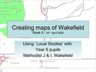
Creating Maps of Wakefield Using Local Studies
- 1. Creating maps of Wakefield Week 5 - 16 th April 2008 Using `Local Studies’ with Year 5 pupils Methodist J & I, Wakefield
- 3. … and re-visited the Methodist Quikmap http://www.quikmaps.com/full/47961
- 8. Katie’s map is one of the most complex and she lists more places than any of the other children. She has not yet grasped the idea that map convention requires North to be at the top of the map. The relative location of some of these places is muddled. This maps shows the route to Ismael’s house and is a fairly accurate route map. The position or shape of the river is not accurately drawn suggesting that children would benefit from looking at OS maps & Google Earth. Route to the Showcase cinema from school and possibly home
- 9. These maps cover an area close to the school. In the top left example only the locality of the school is shown, whereas the other two maps also include Thornes Park. All of these map-makers use the convention of line to depict routeways and solid squares and rectangles to represent larger spaces, e.g fields and parks. The maps all show North at the top of the page. Using line and space
- 10. Nathan and Tobie are the only pair that chose to represent an area to the south of the school. This area basically shows the route to the Asda supermarket. They have not accurately located Pugneys Lake which is to the west of the supermarket. Lines and space are represented on this map. Interestingly the railway line is shown as a pictorial representation, something that is often done by much younger children.
- 11. I find this to be one of the most interesting of the maps drawn. First because it uses a spatial representation to show the buildings, similar to a large scale OS map and second because it is based on a grid. You could find your way easily using this map. North is at the top The map still uses pictograms (the main featured key in Local Studies). We probably need to moving onto exploring map convention next.
- 12. Finally I have selected these two maps because the children have started by representing areas of land (and water) that have a particular meaning for them, i.e. sporting places and leisure places. Neither of these maps are complete and it seems likely that these four children would go on to add routeways when they complete their maps.