Planning starter
•Download as DOC, PDF•
1 like•422 views

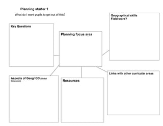
Outline planning framework - useful when gathering ideas
Report
Share
Report
Share
Recommended
Planning for Geography & Global Learning: Chembakolli
This document provides resources for teaching about India, including videos, maps, and websites. It suggests activities like having a guest speaker who has visited India, writing letters to a sponsored child in India, and using maps and images to explore different regions of the country. Questions are posed about what children will learn and do in their project. The resources listed could be used to introduce children to India's varied landscapes, cultures, and ways of life.
Water, water everywhere
A teacher project developed as part of the DfID funded Geography and Global Dimension project run jointly by the Geographical Association and DfID.
Travels in the ACT, Australia 2008
1. The document summarizes a nature walk through a reserve near Canberra, Australia where the author spots various wildlife.
2. They observe echidnas and birds like the Crimson Rosella.
3. The walk concludes with the observation that a new housing development is being built near the reserve, raising questions about protecting the wildlife.
Teaching about a Village in India
This document summarizes a project undertaken by Year 4 students at Jump Primary School to investigate the village of Chembakolli in India. The students used maps, globes and the internet to locate Chembakolli. They then imagined the journey they would take to get there, stopping in New Delhi before taking a train, bus and rickshaw to reach the village. Upon learning more about Chembakolli through photographs, the students were inspired to make positive changes to improve their own behavior, attitudes and learning at school.
Leading the way in Primary Geography
This document provides an overview of a seminar focused on supporting subject leadership in primary geography. It introduces the Primary Geography Quality Mark (PGQM) as a tool for developing, evaluating, and gaining recognition for geography curriculum quality. Key areas that underpin effective subject leadership are discussed using examples from PGQM schools. The seminar focuses on developing a vision for geography and recognizing geographical achievement. Effective geography curriculum is described as living geography that enhances students' understanding of their identity, community, and world.
Year 3 Geography: Local & Global
Part 1: St Catherine’s Catholic Primary School, Sheffield. Developed by Lynne Biggs as part of the Geography and the Global Dimension Project - a joint project run by DECSY and the Geographical Association
Geography: Visual literacy
The skills and understanding needed to use images are basically the same as those needed to read texts.
Year 3 Geography: Local & Global
Part2: St Catherine’s Catholic Primary School, Sheffield. Developed by Lynne Biggs as part of the Geography and the Global Dimension Project - a joint project run by DECSY and the Geographical Association
Geography and the Global Dimension
Developed for the Geography & Global Citizenship course, run in conjunction with DECSY with funding from DfID.
Planning for Global Learning
Developed for the Geography & Global Citizenship course, run in conjunction with DECSY with funding from DfID.
PGQM - Leading the way
The document discusses the Primary Geography Quality Mark (PGQM), which is a framework used by schools in the UK to evaluate and improve their geography curriculum. It provides examples of how schools have used the PGQM to highlight effective geography teaching, raise the profile of geography, and develop their curriculum. The PGQM self-assessment framework guides schools through an auditing process to identify strengths and areas for growth in their geography program.
What is geography?
A fun way to identify distinctly geographical activity - it works in conjunction with a matrix - checklist - see Leading the Way,
Geography is a key subject
Words written by Professor Simon Catlin in the introduction to `Understanding and Developing Primary Geography', in the Primary Geography Handbook, 2004, The GA, Ed. Stephen Scoffham. They are exemplified here with photographs and examples of work that have , in the main, been submitted by schools that have achieved the Primary Geography Quality Mark.
Student Voice Survey - Feb08
The document summarizes the results of a geography student voice questionnaire collected from Dr Thomlinson Middle School in Rothbury. Students indicated that they enjoyed drawing and labeling maps, going on field trips, and learning about different places. They wanted more map work, field trips, fun games, practical work, posters, internet use, and information about the environment. Students wanted less map work, less time sitting and working from textbooks, and less written work. To improve the geography student voice board, students suggested displaying student work, using more colorful maps, and providing more interesting facts and information about what each year is studying.
Geography on display
William Shrewsbury Primary School featured several geography displays and activities for different year levels. The foundation stage held orienteering activities and a display based on the story "Going on a Bear Hunt". Key stage 1 had displays exploring Africa and China. Key stage 2 had a hall display and the year 5 classroom featured topics on rivers, fieldwork, water, and the environment.
Map It Picture It Write It (Part 2)
Part 2 of a PowerPoint presentation that I gave at the TES Conference, London, 2nd October 2010: Discover a range of digital learning resources and internet sites which teacher's can use in innovative ways to develop children's creative writing, their geographical imaginations and personal geographies.
Photographs for geography
Geograph is a photography project that provides high quality images covering every square kilometer of the UK. The images are shared under Creative Commons licenses, allowing their use in classrooms without breaking copyright. Geograph images meet size and quality criteria for display on interactive whiteboards. Other sources of appropriate images include Flickr and Picasa under their Creative Commons options, as well as sites from National Geographic, NASA, and the BBC that may require checking copyright. The Geographical Association also has freely available images to support geography teaching activities.
City of the week
An interactive powerpoint. (If you want the interactive element to work you will need to download this slideshow). Show one image at the start of each am/pm class session (or modify the Powerpoint text to adapt to your own needs). The aim is to see how quickly someone in your class can identify the correct city. There is nothing to stop them doing a bit of their own research using the internet. Have a class suggestions box for children to post their ideas. This is quite a difficult one (shown to adults). Change the pictures and make a much simpler version for your class - depending on their age.
`What If ...' start with a book
This document provides a suggested lesson plan about recycling centered around the book "What If? A book about recycling". The plan incorporates geography, science, art, and citizenship topics. It includes ideas for activities like sculpting with recycled objects, studying coastal erosion, and role playing traveling with recycled materials. The overall goal is to explore recycling and sustainability through the lens of a fictional story.
The PGQM: Supporting Quality Geography
Presentation used at the GA Conference in April 2009 to share ways that the PGQM can support Quality Geography in primary schools.
Mapping images the digital way
A slideshow prepared for an ICT workshop at the UK Geographical Association 2009 Conference. This was a hands-on session and the slideshow was given to each participant to provide them with direct web links and additional `how to ...' guidance so that they could complete a `project'.
Assessment for Learning at St Peter's Primary School Billericay
Some of the steps that the subject leader at St Peter's school has put in place to support assessment.
How the PGQM can support you to develop quality geography
The document discusses how a school's geography program can support students and enhance quality. It provides examples of how hands-on geography activities promote student enjoyment and engagement with the subject. These activities also encourage geographical thinking and make connections across the curriculum. The document advocates for a living, place-based geography curriculum focused on students' lives and futures to develop active, informed citizens.
In the Picture: developing visual literacy through geography and history
The document discusses using images to develop learning in geography and history. It emphasizes that visual literacy skills like observing, predicting, deducing and interpreting images need to be explicitly taught to students. Teachers should use images along with text to help students become better learners and understand different places, time periods and societies. The document provides examples of classroom activities that develop these skills, such as putting students in the perspective of characters in photos and having them describe what they see, hear, smell and feel.
Thinking Geographically
The document discusses various approaches and ideas for teaching geography effectively in primary schools. It emphasizes using real world examples, starting with topics that interest students and are relevant to their lives, and incorporating fieldwork, map skills, images and questions to facilitate inquiry-based learning. Geography lessons should explore students' identities, communities and environment to bring the subject alive and enhance their understanding of the world.
Top Ten Places In Wakefield
Using map data from the OS/BECTA pilot project with the software programme `Local Studies'. The children involved were Y5.
Creating Maps of Wakefield Using Local Studies
The document summarizes a lesson where Year 5 students in Wakefield, England created maps of their local area using drawing and symbol tools. Some key points:
- Students created maps of places within Wakefield like routes to school, parks, shops and landmarks. The maps ranged in complexity and accuracy.
- The activity showed the students' spatial awareness and understanding of their local area. It demonstrated what they had learned previously.
- Next steps discussed were completing the maps, adding photos and details, and comparing the student-created maps to printed maps to discuss purposes and conventions.
Create a map using Google `My Maps'
To create a map using Google My Maps, a user must first log into their Google account. They can then add place markers by clicking on icon symbols and placing them on the map. Additional text and images can be added to markers by selecting the rich text option. Images must be linked from an online gallery by copying the direct URL of the image rather than the page URL. The document provides guidance on using various tools and features within Google My Maps to create and share custom maps.
Bossa N’ Roll Records by Ismael Vazquez.
Bossa N Roll Records presentation by Izzy Vazquez for Music Retail and Distribution class at Full Sail University
More Related Content
More from Geoprimary
Geography and the Global Dimension
Developed for the Geography & Global Citizenship course, run in conjunction with DECSY with funding from DfID.
Planning for Global Learning
Developed for the Geography & Global Citizenship course, run in conjunction with DECSY with funding from DfID.
PGQM - Leading the way
The document discusses the Primary Geography Quality Mark (PGQM), which is a framework used by schools in the UK to evaluate and improve their geography curriculum. It provides examples of how schools have used the PGQM to highlight effective geography teaching, raise the profile of geography, and develop their curriculum. The PGQM self-assessment framework guides schools through an auditing process to identify strengths and areas for growth in their geography program.
What is geography?
A fun way to identify distinctly geographical activity - it works in conjunction with a matrix - checklist - see Leading the Way,
Geography is a key subject
Words written by Professor Simon Catlin in the introduction to `Understanding and Developing Primary Geography', in the Primary Geography Handbook, 2004, The GA, Ed. Stephen Scoffham. They are exemplified here with photographs and examples of work that have , in the main, been submitted by schools that have achieved the Primary Geography Quality Mark.
Student Voice Survey - Feb08
The document summarizes the results of a geography student voice questionnaire collected from Dr Thomlinson Middle School in Rothbury. Students indicated that they enjoyed drawing and labeling maps, going on field trips, and learning about different places. They wanted more map work, field trips, fun games, practical work, posters, internet use, and information about the environment. Students wanted less map work, less time sitting and working from textbooks, and less written work. To improve the geography student voice board, students suggested displaying student work, using more colorful maps, and providing more interesting facts and information about what each year is studying.
Geography on display
William Shrewsbury Primary School featured several geography displays and activities for different year levels. The foundation stage held orienteering activities and a display based on the story "Going on a Bear Hunt". Key stage 1 had displays exploring Africa and China. Key stage 2 had a hall display and the year 5 classroom featured topics on rivers, fieldwork, water, and the environment.
Map It Picture It Write It (Part 2)
Part 2 of a PowerPoint presentation that I gave at the TES Conference, London, 2nd October 2010: Discover a range of digital learning resources and internet sites which teacher's can use in innovative ways to develop children's creative writing, their geographical imaginations and personal geographies.
Photographs for geography
Geograph is a photography project that provides high quality images covering every square kilometer of the UK. The images are shared under Creative Commons licenses, allowing their use in classrooms without breaking copyright. Geograph images meet size and quality criteria for display on interactive whiteboards. Other sources of appropriate images include Flickr and Picasa under their Creative Commons options, as well as sites from National Geographic, NASA, and the BBC that may require checking copyright. The Geographical Association also has freely available images to support geography teaching activities.
City of the week
An interactive powerpoint. (If you want the interactive element to work you will need to download this slideshow). Show one image at the start of each am/pm class session (or modify the Powerpoint text to adapt to your own needs). The aim is to see how quickly someone in your class can identify the correct city. There is nothing to stop them doing a bit of their own research using the internet. Have a class suggestions box for children to post their ideas. This is quite a difficult one (shown to adults). Change the pictures and make a much simpler version for your class - depending on their age.
`What If ...' start with a book
This document provides a suggested lesson plan about recycling centered around the book "What If? A book about recycling". The plan incorporates geography, science, art, and citizenship topics. It includes ideas for activities like sculpting with recycled objects, studying coastal erosion, and role playing traveling with recycled materials. The overall goal is to explore recycling and sustainability through the lens of a fictional story.
The PGQM: Supporting Quality Geography
Presentation used at the GA Conference in April 2009 to share ways that the PGQM can support Quality Geography in primary schools.
Mapping images the digital way
A slideshow prepared for an ICT workshop at the UK Geographical Association 2009 Conference. This was a hands-on session and the slideshow was given to each participant to provide them with direct web links and additional `how to ...' guidance so that they could complete a `project'.
Assessment for Learning at St Peter's Primary School Billericay
Some of the steps that the subject leader at St Peter's school has put in place to support assessment.
How the PGQM can support you to develop quality geography
The document discusses how a school's geography program can support students and enhance quality. It provides examples of how hands-on geography activities promote student enjoyment and engagement with the subject. These activities also encourage geographical thinking and make connections across the curriculum. The document advocates for a living, place-based geography curriculum focused on students' lives and futures to develop active, informed citizens.
In the Picture: developing visual literacy through geography and history
The document discusses using images to develop learning in geography and history. It emphasizes that visual literacy skills like observing, predicting, deducing and interpreting images need to be explicitly taught to students. Teachers should use images along with text to help students become better learners and understand different places, time periods and societies. The document provides examples of classroom activities that develop these skills, such as putting students in the perspective of characters in photos and having them describe what they see, hear, smell and feel.
Thinking Geographically
The document discusses various approaches and ideas for teaching geography effectively in primary schools. It emphasizes using real world examples, starting with topics that interest students and are relevant to their lives, and incorporating fieldwork, map skills, images and questions to facilitate inquiry-based learning. Geography lessons should explore students' identities, communities and environment to bring the subject alive and enhance their understanding of the world.
Top Ten Places In Wakefield
Using map data from the OS/BECTA pilot project with the software programme `Local Studies'. The children involved were Y5.
Creating Maps of Wakefield Using Local Studies
The document summarizes a lesson where Year 5 students in Wakefield, England created maps of their local area using drawing and symbol tools. Some key points:
- Students created maps of places within Wakefield like routes to school, parks, shops and landmarks. The maps ranged in complexity and accuracy.
- The activity showed the students' spatial awareness and understanding of their local area. It demonstrated what they had learned previously.
- Next steps discussed were completing the maps, adding photos and details, and comparing the student-created maps to printed maps to discuss purposes and conventions.
Create a map using Google `My Maps'
To create a map using Google My Maps, a user must first log into their Google account. They can then add place markers by clicking on icon symbols and placing them on the map. Additional text and images can be added to markers by selecting the rich text option. Images must be linked from an online gallery by copying the direct URL of the image rather than the page URL. The document provides guidance on using various tools and features within Google My Maps to create and share custom maps.
More from Geoprimary (20)
Assessment for Learning at St Peter's Primary School Billericay
Assessment for Learning at St Peter's Primary School Billericay
How the PGQM can support you to develop quality geography
How the PGQM can support you to develop quality geography
In the Picture: developing visual literacy through geography and history
In the Picture: developing visual literacy through geography and history
Recently uploaded
Bossa N’ Roll Records by Ismael Vazquez.
Bossa N Roll Records presentation by Izzy Vazquez for Music Retail and Distribution class at Full Sail University
Educational Technology in the Health Sciences
Plenary presentation at the NTTC Inter-university Workshop, 18 June 2024, Manila Prince Hotel.
BÀI TẬP DẠY THÊM TIẾNG ANH LỚP 7 CẢ NĂM FRIENDS PLUS SÁCH CHÂN TRỜI SÁNG TẠO ...
BÀI TẬP DẠY THÊM TIẾNG ANH LỚP 7 CẢ NĂM FRIENDS PLUS SÁCH CHÂN TRỜI SÁNG TẠO ...Nguyen Thanh Tu Collection
https://app.box.com/s/qhtvq32h4ybf9t49ku85x0n3xl4jhr15What is Digital Literacy? A guest blog from Andy McLaughlin, University of Ab...
What is Digital Literacy? A guest blog from Andy McLaughlin, University of Aberdeen
Mule event processing models | MuleSoft Mysore Meetup #47
Mule event processing models | MuleSoft Mysore Meetup #47
Event Link:- https://meetups.mulesoft.com/events/details/mulesoft-mysore-presents-mule-event-processing-models/
Agenda
● What is event processing in MuleSoft?
● Types of event processing models in Mule 4
● Distinction between the reactive, parallel, blocking & non-blocking processing
For Upcoming Meetups Join Mysore Meetup Group - https://meetups.mulesoft.com/mysore/YouTube:- youtube.com/@mulesoftmysore
Mysore WhatsApp group:- https://chat.whatsapp.com/EhqtHtCC75vCAX7gaO842N
Speaker:-
Shivani Yasaswi - https://www.linkedin.com/in/shivaniyasaswi/
Organizers:-
Shubham Chaurasia - https://www.linkedin.com/in/shubhamchaurasia1/
Giridhar Meka - https://www.linkedin.com/in/giridharmeka
Priya Shaw - https://www.linkedin.com/in/priya-shaw
skeleton System.pdf (skeleton system wow)
🔥🔥🔥🔥🔥🔥🔥🔥🔥
إضغ بين إيديكم من أقوى الملازم التي صممتها
ملزمة تشريح الجهاز الهيكلي (نظري 3)
💀💀💀💀💀💀💀💀💀💀
تتميز هذهِ الملزمة بعِدة مُميزات :
1- مُترجمة ترجمة تُناسب جميع المستويات
2- تحتوي على 78 رسم توضيحي لكل كلمة موجودة بالملزمة (لكل كلمة !!!!)
#فهم_ماكو_درخ
3- دقة الكتابة والصور عالية جداً جداً جداً
4- هُنالك بعض المعلومات تم توضيحها بشكل تفصيلي جداً (تُعتبر لدى الطالب أو الطالبة بإنها معلومات مُبهمة ومع ذلك تم توضيح هذهِ المعلومات المُبهمة بشكل تفصيلي جداً
5- الملزمة تشرح نفسها ب نفسها بس تكلك تعال اقراني
6- تحتوي الملزمة في اول سلايد على خارطة تتضمن جميع تفرُعات معلومات الجهاز الهيكلي المذكورة في هذهِ الملزمة
واخيراً هذهِ الملزمة حلالٌ عليكم وإتمنى منكم إن تدعولي بالخير والصحة والعافية فقط
كل التوفيق زملائي وزميلاتي ، زميلكم محمد الذهبي 💊💊
🔥🔥🔥🔥🔥🔥🔥🔥🔥
Gender and Mental Health - Counselling and Family Therapy Applications and In...
A proprietary approach developed by bringing together the best of learning theories from Psychology, design principles from the world of visualization, and pedagogical methods from over a decade of training experience, that enables you to: Learn better, faster!
BÀI TẬP BỔ TRỢ TIẾNG ANH LỚP 9 CẢ NĂM - GLOBAL SUCCESS - NĂM HỌC 2024-2025 - ...
BÀI TẬP BỔ TRỢ TIẾNG ANH LỚP 9 CẢ NĂM - GLOBAL SUCCESS - NĂM HỌC 2024-2025 - ...Nguyen Thanh Tu Collection
https://app.box.com/s/tacvl9ekroe9hqupdnjruiypvm9rdaneJemison, MacLaughlin, and Majumder "Broadening Pathways for Editors and Authors"
Jemison, MacLaughlin, and Majumder "Broadening Pathways for Editors and Authors"National Information Standards Organization (NISO)
This presentation was provided by Racquel Jemison, Ph.D., Christina MacLaughlin, Ph.D., and Paulomi Majumder. Ph.D., all of the American Chemical Society, for the second session of NISO's 2024 Training Series "DEIA in the Scholarly Landscape." Session Two: 'Expanding Pathways to Publishing Careers,' was held June 13, 2024.Chapter wise All Notes of First year Basic Civil Engineering.pptx
Chapter wise All Notes of First year Basic Civil Engineering
Syllabus
Chapter-1
Introduction to objective, scope and outcome the subject
Chapter 2
Introduction: Scope and Specialization of Civil Engineering, Role of civil Engineer in Society, Impact of infrastructural development on economy of country.
Chapter 3
Surveying: Object Principles & Types of Surveying; Site Plans, Plans & Maps; Scales & Unit of different Measurements.
Linear Measurements: Instruments used. Linear Measurement by Tape, Ranging out Survey Lines and overcoming Obstructions; Measurements on sloping ground; Tape corrections, conventional symbols. Angular Measurements: Instruments used; Introduction to Compass Surveying, Bearings and Longitude & Latitude of a Line, Introduction to total station.
Levelling: Instrument used Object of levelling, Methods of levelling in brief, and Contour maps.
Chapter 4
Buildings: Selection of site for Buildings, Layout of Building Plan, Types of buildings, Plinth area, carpet area, floor space index, Introduction to building byelaws, concept of sun light & ventilation. Components of Buildings & their functions, Basic concept of R.C.C., Introduction to types of foundation
Chapter 5
Transportation: Introduction to Transportation Engineering; Traffic and Road Safety: Types and Characteristics of Various Modes of Transportation; Various Road Traffic Signs, Causes of Accidents and Road Safety Measures.
Chapter 6
Environmental Engineering: Environmental Pollution, Environmental Acts and Regulations, Functional Concepts of Ecology, Basics of Species, Biodiversity, Ecosystem, Hydrological Cycle; Chemical Cycles: Carbon, Nitrogen & Phosphorus; Energy Flow in Ecosystems.
Water Pollution: Water Quality standards, Introduction to Treatment & Disposal of Waste Water. Reuse and Saving of Water, Rain Water Harvesting. Solid Waste Management: Classification of Solid Waste, Collection, Transportation and Disposal of Solid. Recycling of Solid Waste: Energy Recovery, Sanitary Landfill, On-Site Sanitation. Air & Noise Pollution: Primary and Secondary air pollutants, Harmful effects of Air Pollution, Control of Air Pollution. . Noise Pollution Harmful Effects of noise pollution, control of noise pollution, Global warming & Climate Change, Ozone depletion, Greenhouse effect
Text Books:
1. Palancharmy, Basic Civil Engineering, McGraw Hill publishers.
2. Satheesh Gopi, Basic Civil Engineering, Pearson Publishers.
3. Ketki Rangwala Dalal, Essentials of Civil Engineering, Charotar Publishing House.
4. BCP, Surveying volume 1
Recently uploaded (20)
BÀI TẬP DẠY THÊM TIẾNG ANH LỚP 7 CẢ NĂM FRIENDS PLUS SÁCH CHÂN TRỜI SÁNG TẠO ...
BÀI TẬP DẠY THÊM TIẾNG ANH LỚP 7 CẢ NĂM FRIENDS PLUS SÁCH CHÂN TRỜI SÁNG TẠO ...
What is Digital Literacy? A guest blog from Andy McLaughlin, University of Ab...
What is Digital Literacy? A guest blog from Andy McLaughlin, University of Ab...
Mule event processing models | MuleSoft Mysore Meetup #47
Mule event processing models | MuleSoft Mysore Meetup #47
Gender and Mental Health - Counselling and Family Therapy Applications and In...
Gender and Mental Health - Counselling and Family Therapy Applications and In...
BÀI TẬP BỔ TRỢ TIẾNG ANH LỚP 9 CẢ NĂM - GLOBAL SUCCESS - NĂM HỌC 2024-2025 - ...
BÀI TẬP BỔ TRỢ TIẾNG ANH LỚP 9 CẢ NĂM - GLOBAL SUCCESS - NĂM HỌC 2024-2025 - ...
Juneteenth Freedom Day 2024 David Douglas School District
Juneteenth Freedom Day 2024 David Douglas School District
Jemison, MacLaughlin, and Majumder "Broadening Pathways for Editors and Authors"
Jemison, MacLaughlin, and Majumder "Broadening Pathways for Editors and Authors"
spot a liar (Haiqa 146).pptx Technical writhing and presentation skills
spot a liar (Haiqa 146).pptx Technical writhing and presentation skills
Chapter wise All Notes of First year Basic Civil Engineering.pptx
Chapter wise All Notes of First year Basic Civil Engineering.pptx