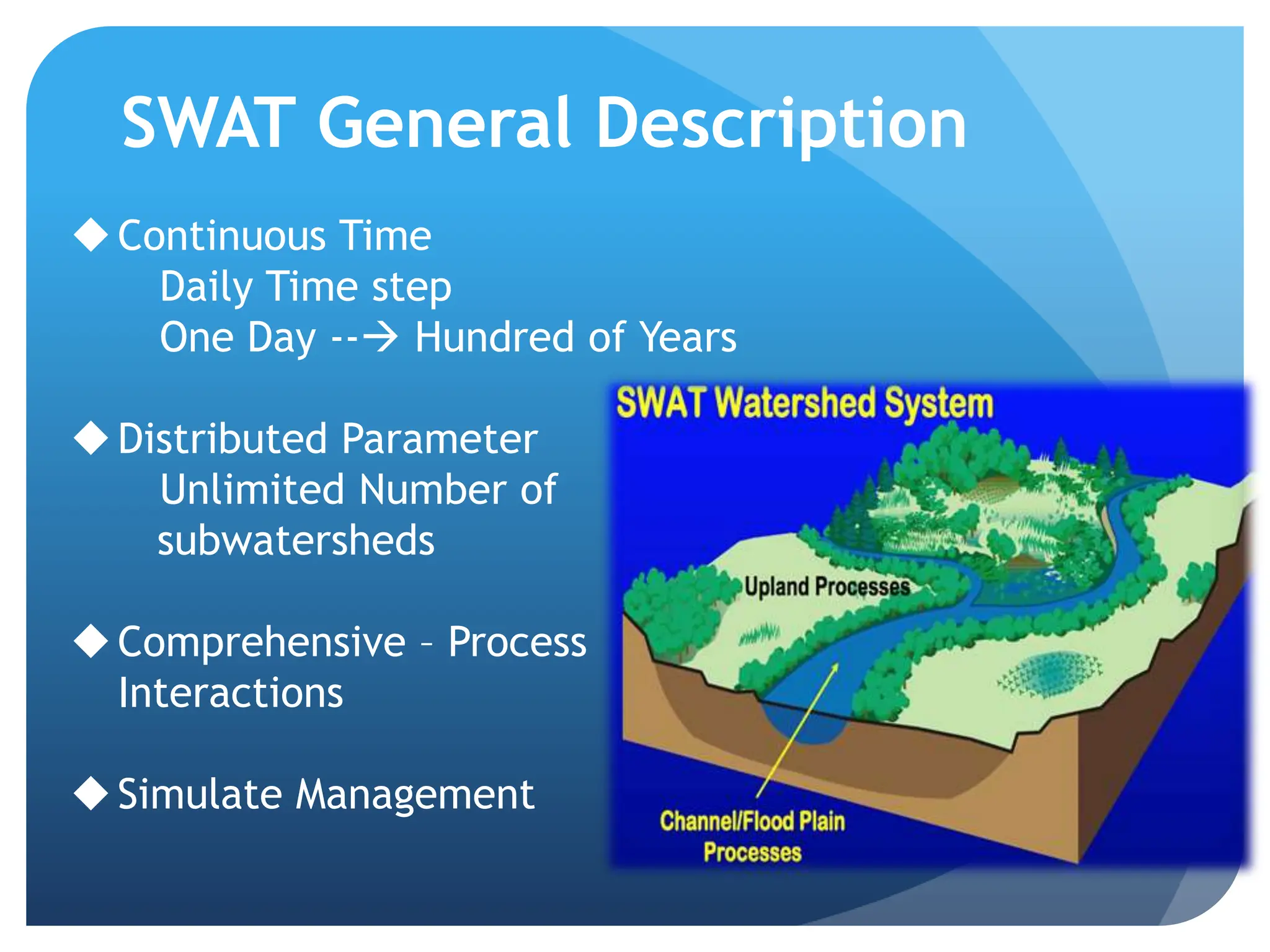
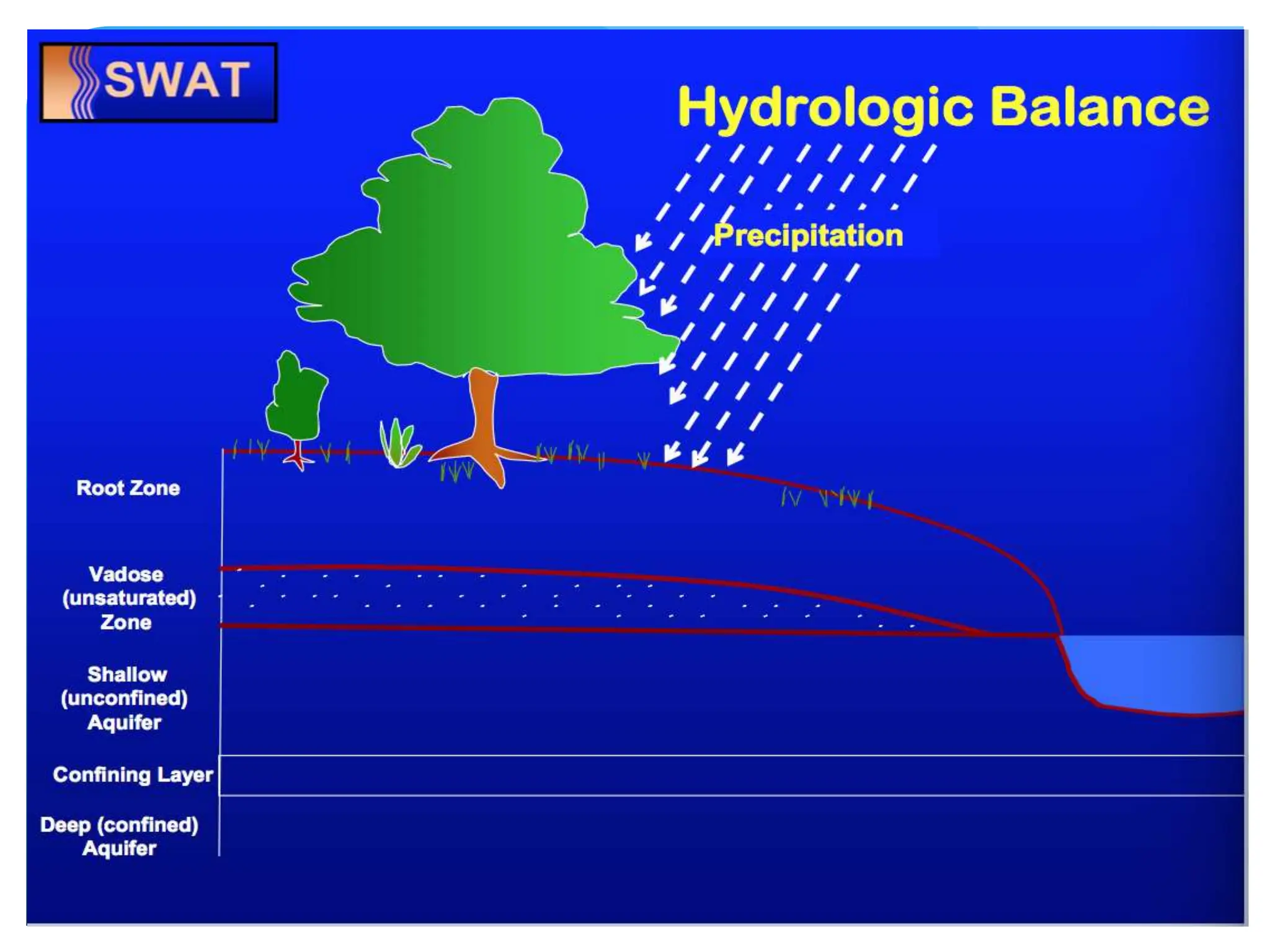
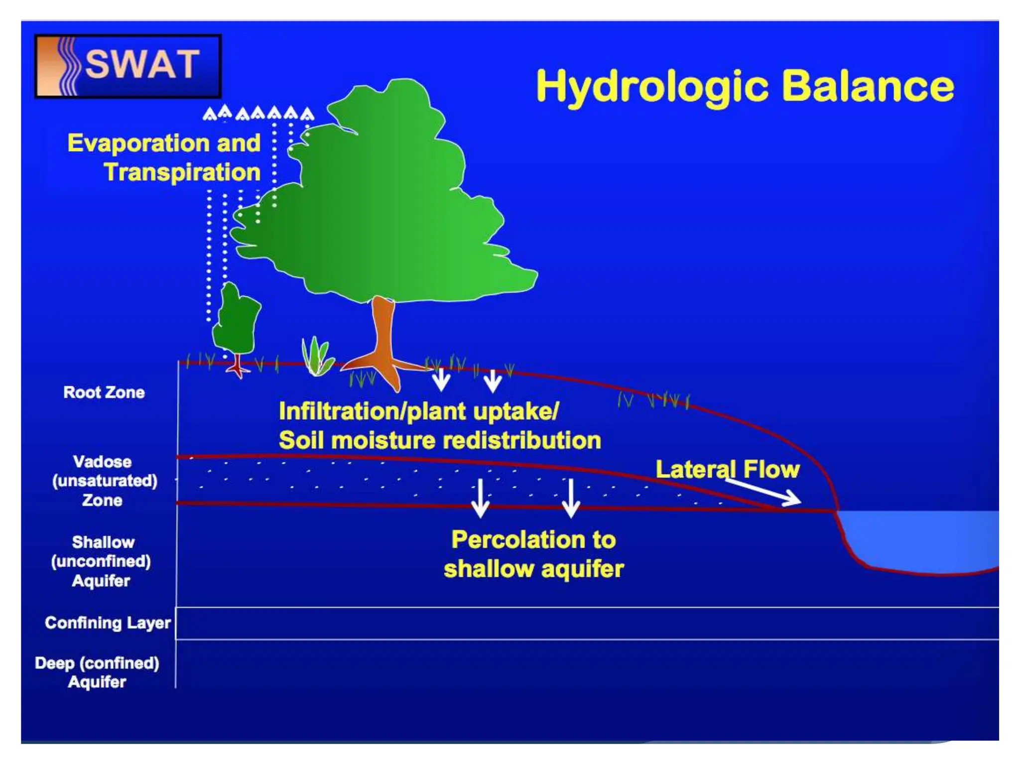
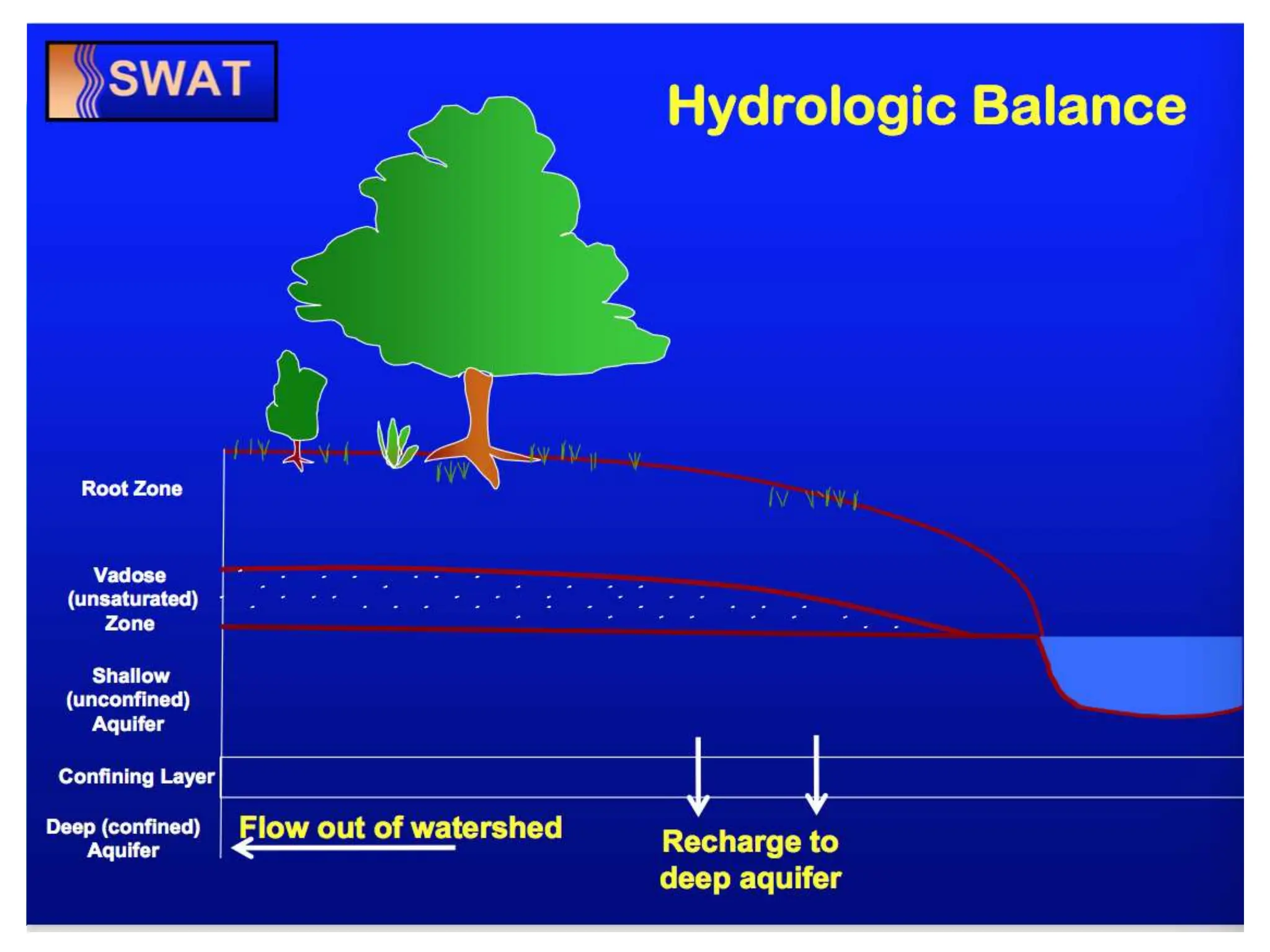
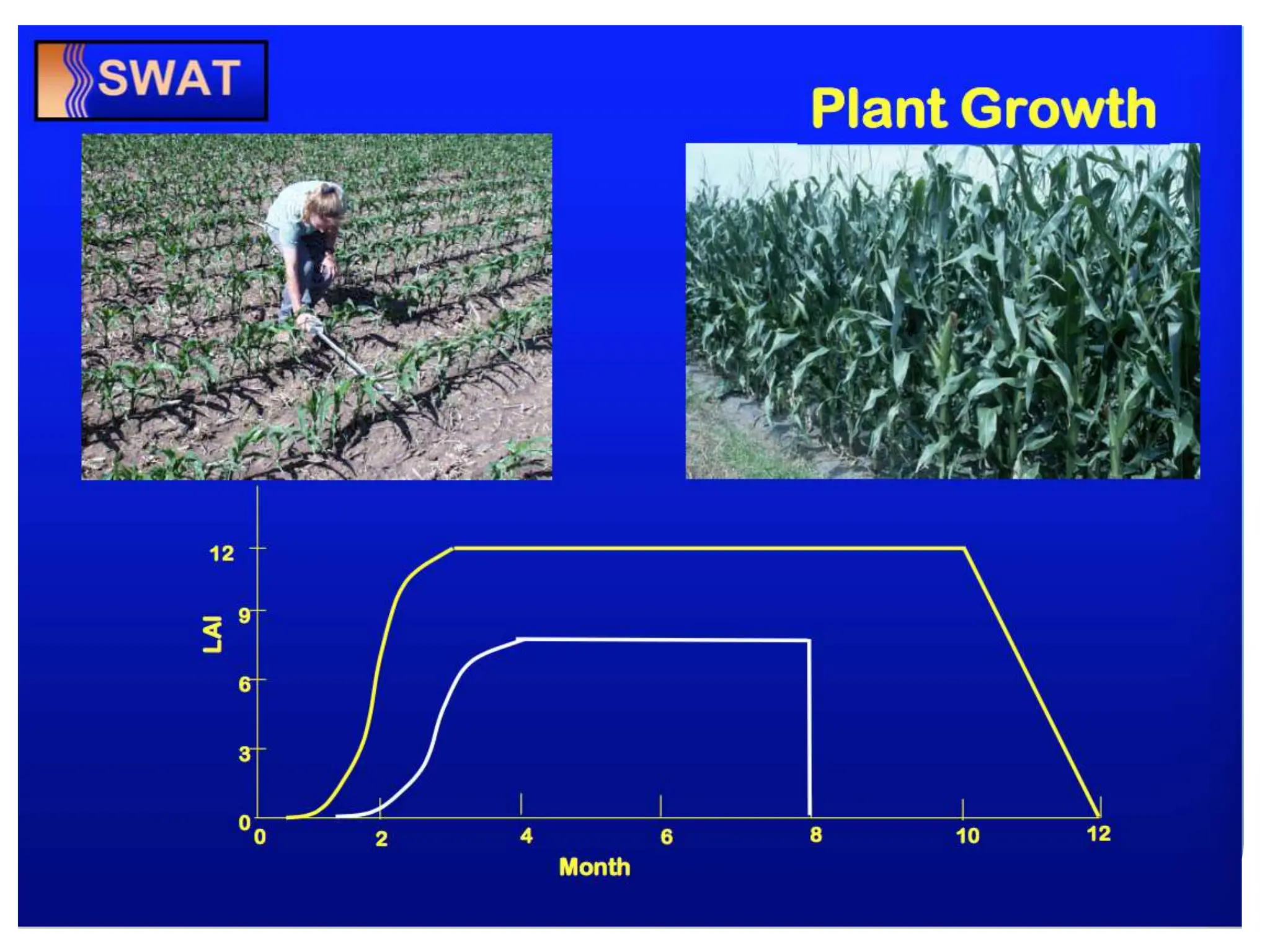
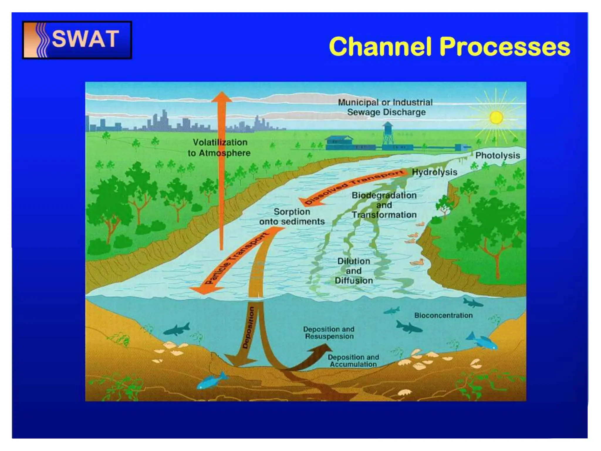
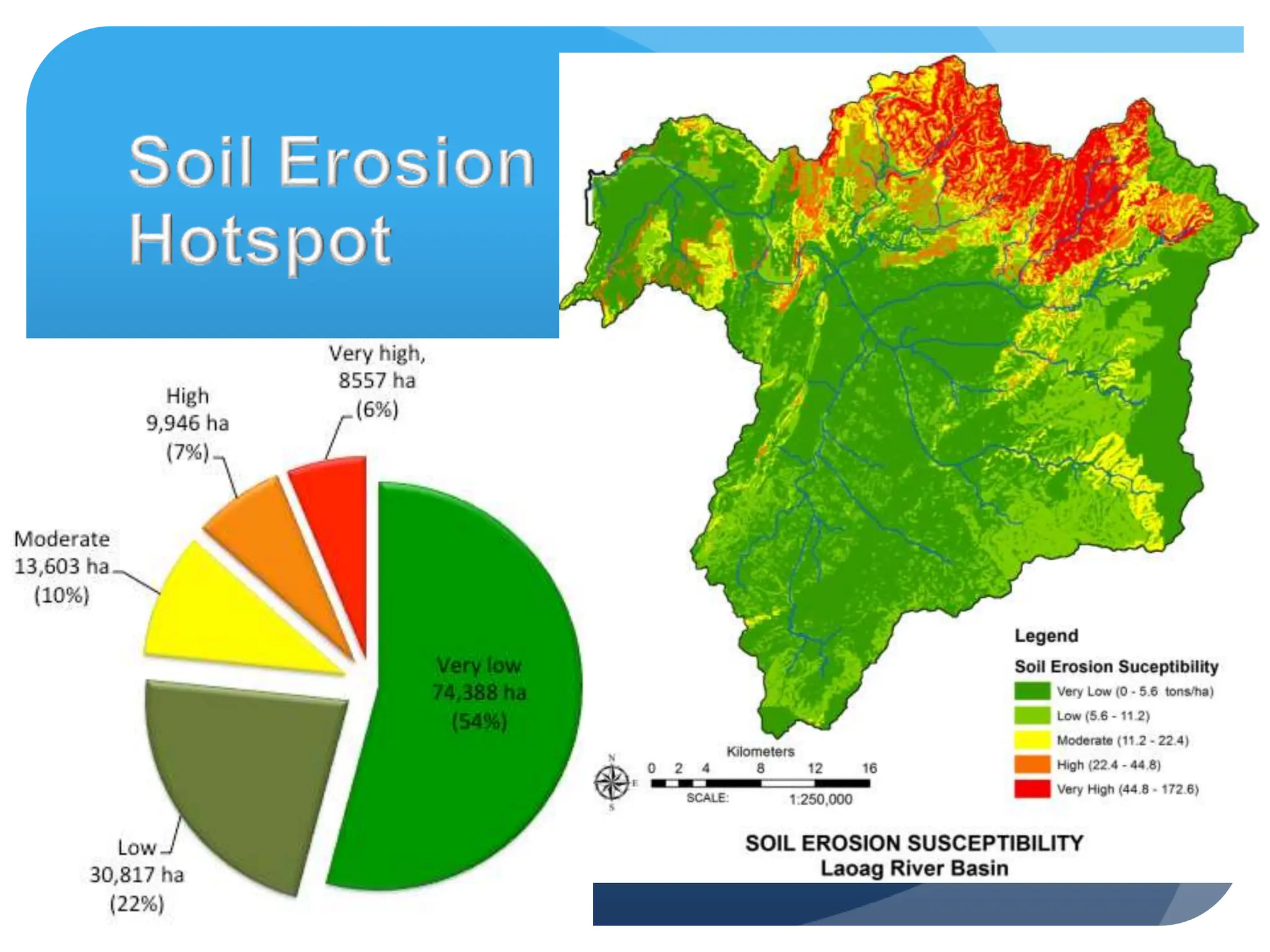
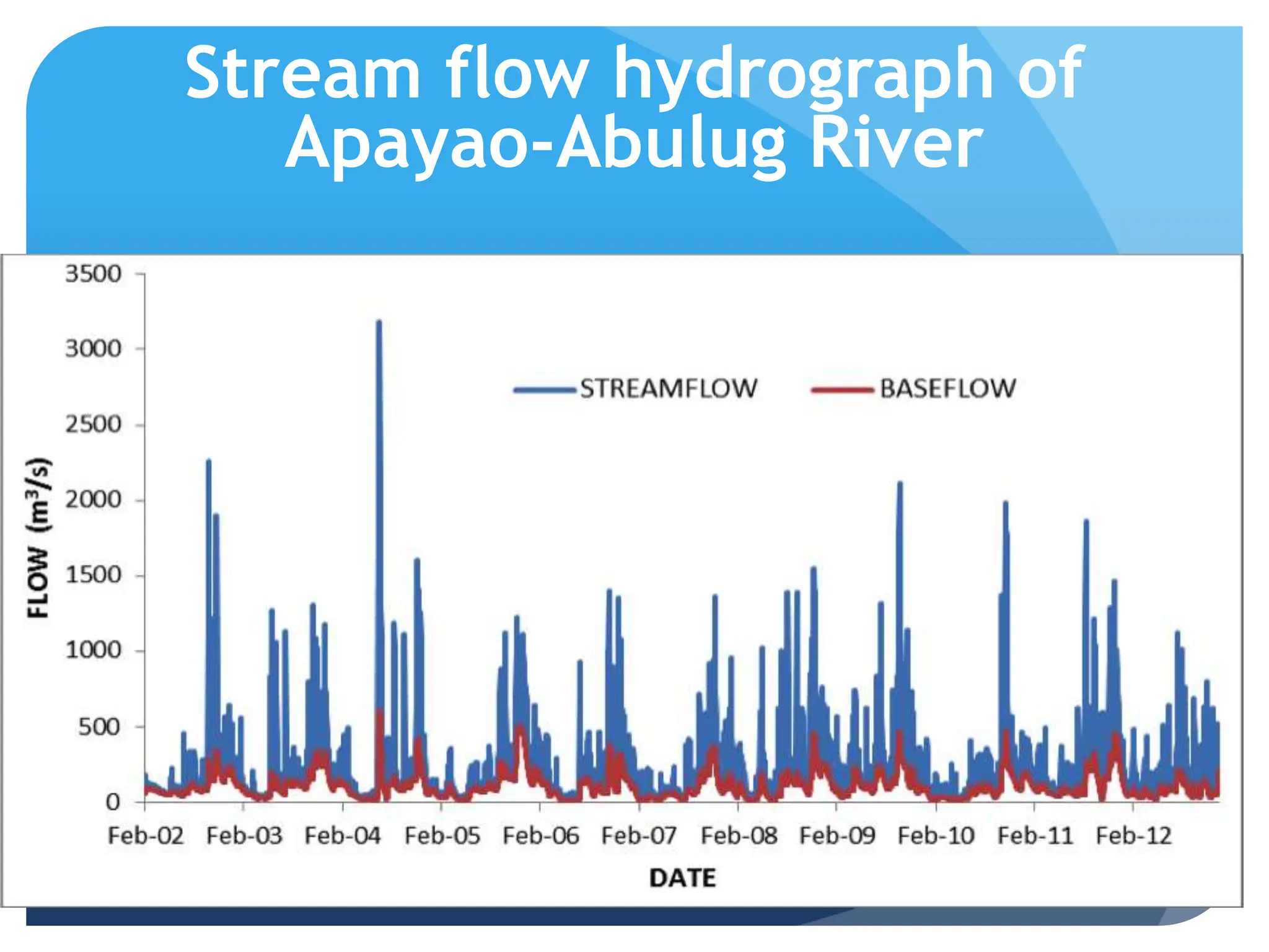
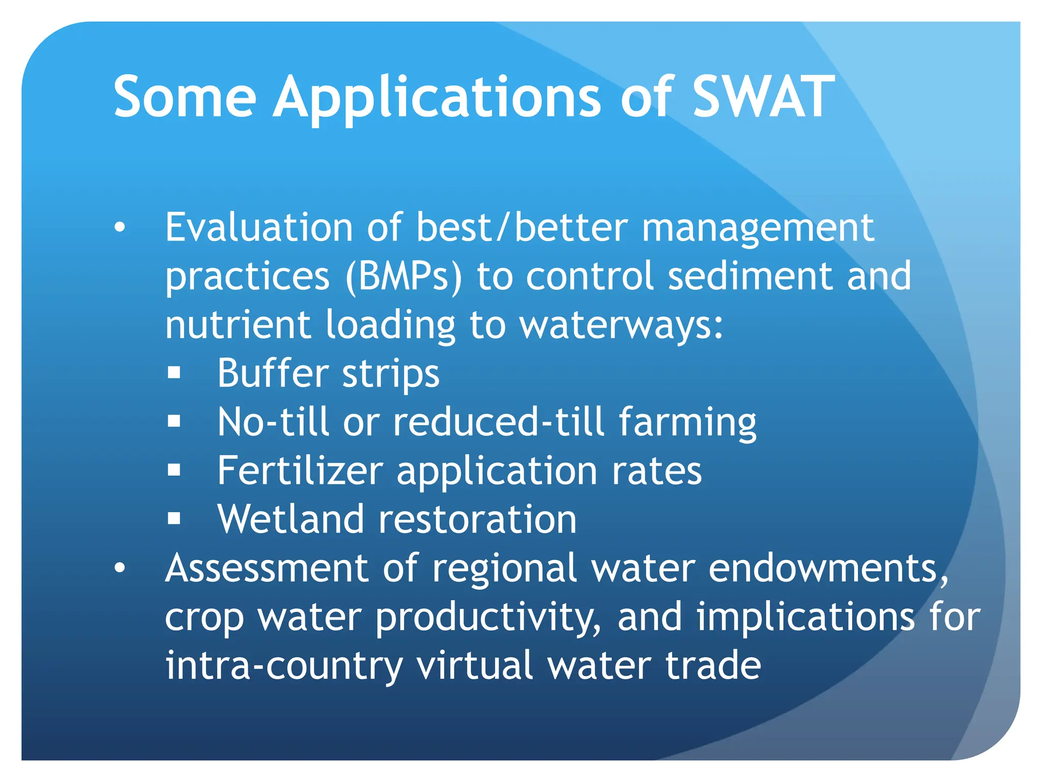
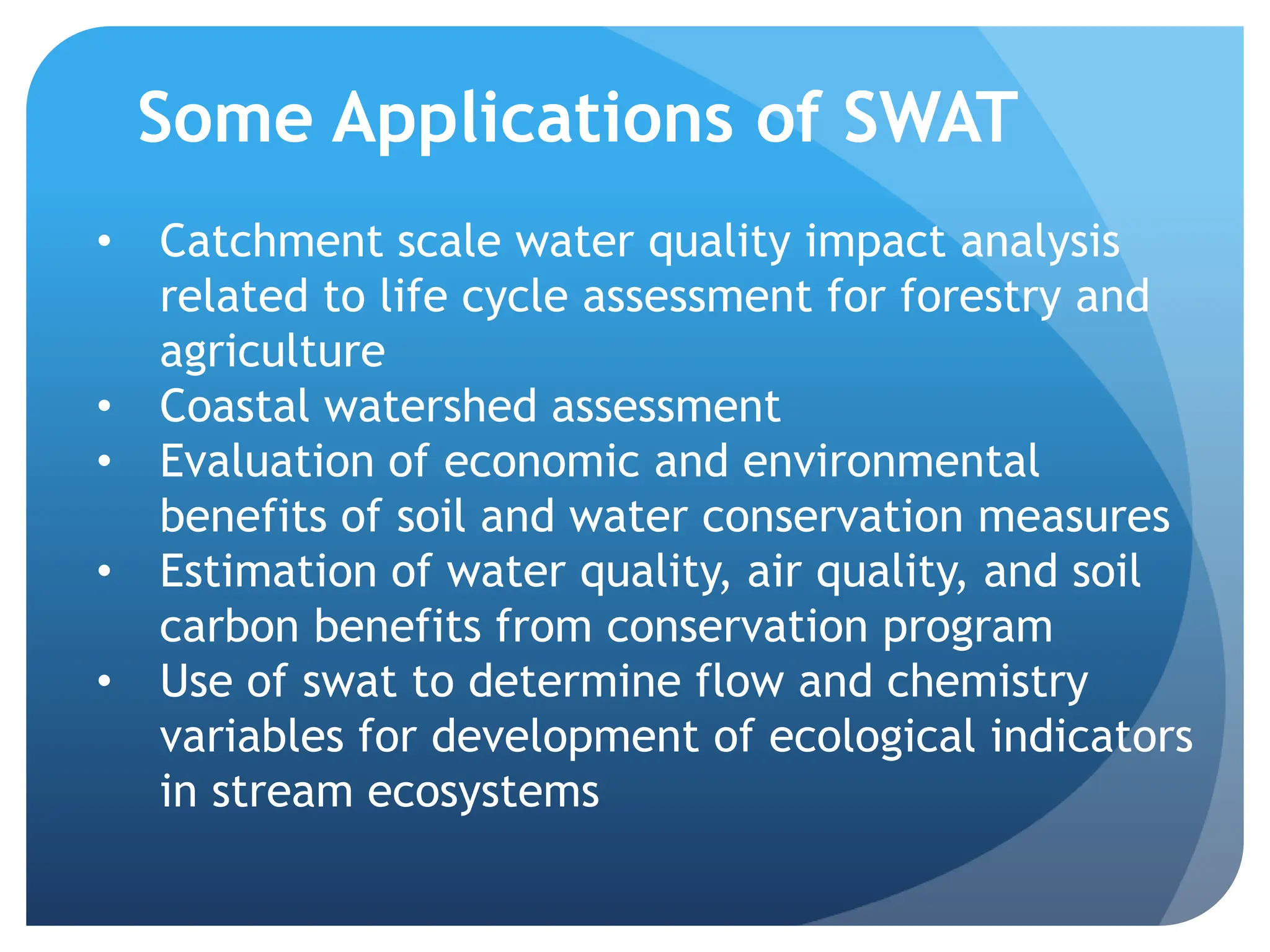
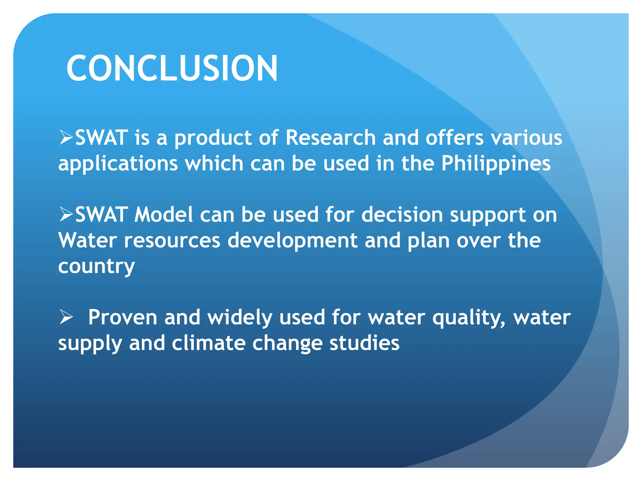
Soil and Water
Assessment Tool
NATHANIEL R. ALIBUYOG
MMSU, Batac, Ilocos Norte
Model Philosophy
 Readily available input –
Physically based
 Computer efficient
 Comprehensive – Process
interaction
 Simulate Management
Modeling History: Time Line
USLE
CREAMS
(Clean Water Act) EPIC SWRRB SWAT
1960’s 1970’s 1980’s 1990’s
GLEAMS WEPP
AGNPS
ANN AGNPS
USLE – plot scale
EPIC – field scale
WEPP – Hillslope scale
APEX – Farm scale
SWAT – watershed scale
APEX
What is SWAT
SWAT is a physically-based, river
basin-scale, continuous event
hydrologic model developed to
quantify the impact of land
management practices on water,
sediment, and agricultural chemical
yields in large, complex watersheds
with varying soils, land use, and
management conditions
Major model components describe
processes associated with water
movement, sediment movement,
soils, temperature, weather, plant
growth, nutrients, pesticides and
land management.
SWAT General Description
Continuous Time
Daily Time step
One Day -- Hundred of Years
Distributed Parameter
Unlimited Number of
subwatersheds
Comprehensive – Process
Interactions
Simulate Management
Upland Processes
o Weather
o Hydrology
o Sedimentation
o Plant Growth
o Nutrient Cycling
o Pesticide Dynamics
o Management
o Bacteria
Some Applications of
SWAT in Water
Resources Planning and
Management
Digital
Elevation
Model
Land use
Map
Soils Map
GIS-
SWAT
Climatic
Database
Landsat
2005
Stream Flow
Erosion Rate
SWAT-
CUP
Stream Flow
Data
Erosion Hotspot
NGP Targeted
Areas
Calibration
Identifying Erosion Hotspot
Predicting the effects of land use and
climate change on watershed hydrology
Impacts of Land use change on watershed
hydrology
Impact of Climate Change on Water
Resources
The four storylines developed by the IPCC which
defines plausible emission scenarios
Comparison of Baseline and Projected Monthly Water
Yield (mm) under Medium-Range Scenario (A1B)
Stream flow hydrograph of
Apayao-Abulug River
Stream flow- Dependable Flow
1960 – 1970
(NWRB)
7.55 MCM/day
1980 – 2010
(Present Study)
5.62 MCM/day
Some Applications of SWAT
SWAT has been extensively used worldwide for various
applications. Among the common applications of SWAT
includes:
o Simulation of watershed hydrologic balance
o Estimation of soil water, recharge, tile flow, and
groundwater level
o Runoff, erosion and sediment studies
o Comprehensive water quality assessments
o Pesticide fate and transport studies
o Assessment of climate change impacts on hydrology
and on pollutant loss
Some Applications of SWAT
• Evaluation of overland or stream/river flow
changes as a result of:
 Retention/detention structures
 Wetland restoration
 BMPs or changes in land use/land cover (such
as no-till farming or conversion of farmland to
grassland)
• Drought planning
• Water supply options
• Regional impacts of climate change on
groundwater recharge and on water supplies
Some Applications of SWAT
• Evaluation of best/better management
practices (BMPs) to control sediment and
nutrient loading to waterways:
 Buffer strips
 No-till or reduced-till farming
 Fertilizer application rates
 Wetland restoration
• Assessment of regional water endowments,
crop water productivity, and implications for
intra-country virtual water trade
Some Applications of SWAT
• Catchment scale water quality impact analysis
related to life cycle assessment for forestry and
agriculture
• Coastal watershed assessment
• Evaluation of economic and environmental
benefits of soil and water conservation measures
• Estimation of water quality, air quality, and soil
carbon benefits from conservation program
• Use of swat to determine flow and chemistry
variables for development of ecological indicators
in stream ecosystems
SWAT is a product of Research and offers various
applications which can be used in the Philippines
SWAT Model can be used for decision support on
Water resources development and plan over the
country
 Proven and widely used for water quality, water
supply and climate change studies
CONCLUSION

Copy of SWAT PPT OverviewCopy of SWAT PPT OverviewCopy of SWAT PPT OverviewCopy of SWAT PPT Overview.pptx

  • 1.
    Soil and Water AssessmentTool NATHANIEL R. ALIBUYOG MMSU, Batac, Ilocos Norte
  • 2.
    Model Philosophy  Readilyavailable input – Physically based  Computer efficient  Comprehensive – Process interaction  Simulate Management
  • 3.
    Modeling History: TimeLine USLE CREAMS (Clean Water Act) EPIC SWRRB SWAT 1960’s 1970’s 1980’s 1990’s GLEAMS WEPP AGNPS ANN AGNPS USLE – plot scale EPIC – field scale WEPP – Hillslope scale APEX – Farm scale SWAT – watershed scale APEX
  • 4.
    What is SWAT SWATis a physically-based, river basin-scale, continuous event hydrologic model developed to quantify the impact of land management practices on water, sediment, and agricultural chemical yields in large, complex watersheds with varying soils, land use, and management conditions Major model components describe processes associated with water movement, sediment movement, soils, temperature, weather, plant growth, nutrients, pesticides and land management.
  • 5.
    SWAT General Description ContinuousTime Daily Time step One Day -- Hundred of Years Distributed Parameter Unlimited Number of subwatersheds Comprehensive – Process Interactions Simulate Management
  • 6.
    Upland Processes o Weather oHydrology o Sedimentation o Plant Growth o Nutrient Cycling o Pesticide Dynamics o Management o Bacteria
  • 34.
    Some Applications of SWATin Water Resources Planning and Management
  • 35.
    Digital Elevation Model Land use Map Soils Map GIS- SWAT Climatic Database Landsat 2005 StreamFlow Erosion Rate SWAT- CUP Stream Flow Data Erosion Hotspot NGP Targeted Areas Calibration Identifying Erosion Hotspot
  • 38.
    Predicting the effectsof land use and climate change on watershed hydrology
  • 39.
    Impacts of Landuse change on watershed hydrology
  • 40.
    Impact of ClimateChange on Water Resources The four storylines developed by the IPCC which defines plausible emission scenarios
  • 41.
    Comparison of Baselineand Projected Monthly Water Yield (mm) under Medium-Range Scenario (A1B)
  • 43.
    Stream flow hydrographof Apayao-Abulug River
  • 44.
    Stream flow- DependableFlow 1960 – 1970 (NWRB) 7.55 MCM/day 1980 – 2010 (Present Study) 5.62 MCM/day
  • 45.
    Some Applications ofSWAT SWAT has been extensively used worldwide for various applications. Among the common applications of SWAT includes: o Simulation of watershed hydrologic balance o Estimation of soil water, recharge, tile flow, and groundwater level o Runoff, erosion and sediment studies o Comprehensive water quality assessments o Pesticide fate and transport studies o Assessment of climate change impacts on hydrology and on pollutant loss
  • 46.
    Some Applications ofSWAT • Evaluation of overland or stream/river flow changes as a result of:  Retention/detention structures  Wetland restoration  BMPs or changes in land use/land cover (such as no-till farming or conversion of farmland to grassland) • Drought planning • Water supply options • Regional impacts of climate change on groundwater recharge and on water supplies
  • 47.
    Some Applications ofSWAT • Evaluation of best/better management practices (BMPs) to control sediment and nutrient loading to waterways:  Buffer strips  No-till or reduced-till farming  Fertilizer application rates  Wetland restoration • Assessment of regional water endowments, crop water productivity, and implications for intra-country virtual water trade
  • 48.
    Some Applications ofSWAT • Catchment scale water quality impact analysis related to life cycle assessment for forestry and agriculture • Coastal watershed assessment • Evaluation of economic and environmental benefits of soil and water conservation measures • Estimation of water quality, air quality, and soil carbon benefits from conservation program • Use of swat to determine flow and chemistry variables for development of ecological indicators in stream ecosystems
  • 49.
    SWAT is aproduct of Research and offers various applications which can be used in the Philippines SWAT Model can be used for decision support on Water resources development and plan over the country  Proven and widely used for water quality, water supply and climate change studies CONCLUSION

Editor's Notes

  • #21 Flood routing using the Variable storage and Muskingum Transmission losses, evaporation Sediment Routing using degradation and deposition which computed simultaneously Nutrient process using the modified QUAL2E and WASP Pesticide using the toxic balance developed at University of Colorado
  • #36 In this exercise, We used GIS together with SWAT (the Soil and Water Assessment Tool) to identify erosion hotspot within the Laoag River Watershed. We used GIS to prepare all spatial data required by the SWAT model. Specifically, GIS was used to delineate watershed boundary, derived river networks and slope maps from DEM. Likewise, we used GIS and RS (ENVI) produce our land use map from LandSat 2005. Spatial variation of soil physical and chemical properties were likewise mapped using GIS. After preparing all these parameters, we used GIS to overlay all the parameters to come up with unique hydrologic response unit that serve as our model unit. These data were then used by the SWAT model to simulate the stream flow and erosion rates in the watershed. From the simulated erosion rates, we then used GIS reclassification tool to identify erosion hotspots.
  • #37 Using GIS, we could easily reclassify and present the simulated erosion rates into soil erosion susceptibility map. The red color erosion hotspot that may be considered priority areas for the National Greening program. The erosion hotspot area account about 6% of the total watershed area or about 8557 ha.
  • #39 As part of the previous modeling exercises, we also use the calibrated model to predict the effects of land use and climate changes on watershed hydrology.
  • #41 Climate change is one of the most fundamental challenges ever to confront humanity. Its adverse impacts are already being seen and may intensify exponentially over time if nothing is done to reduce further emissions of greenhouse gases. Meanwhile, detailed information on plausible future climates, such as changes in temperatures, rainfall and frequency of extreme weather events are important basis for planning for and implementing climate change adaptations. In 2011, PAGASA generated projections of temperature increase and rainfall change in the Philippines using PRECIS (Providing Regional Climates for Impact Studies) model in two time frames; 2020 and 2050. Three of the emission scenarios developed by the Intergovernmental Panel on Climate Change in its Special Report on Emission Scenarios (IPCC-SRES) were used to run the PRECIS model; namely, A2 (high range), A1B (mid-range), and B2 (low-range). These emission scenarios cover a range of demographic, societal, economic and technological storylines. Table 2.4 presents the four different storylines (A1, A2, B1, and B2) as defined in the IPCC-SRES.  
  • #42 Results of the simulation showed there would be likely increase in water yield (Figure 2.12) and surface runoff (Figure 2.13) in 2020 and 2050 time slices as a result of the increase annual rainfall amount in the basin. In spite of the overall increase of annual water yield, water yield during the summer months (MAM), would likely decrease by as much as 34% as consequence of less rainfall during the summer months. It is imperative therefore that water savings of excess rainfall during the rainy season be adopted to be used during the dry months.
  • #43 Similarly, we were able to show that changes in precipitation may affect the watershed hydrology. Increased in precipitation may results to increase runoff, stream flow but may not significantly increase groundwater recharge. This is considering the present land use of the watershed.