SlideShare a Scribd company logo
i
RAINFALL INTENSITY-DURATION-FREQUENCY ANALYSIS
UNDER CHANGING CLIMATE SCENARIO IN SELECTED STATIONS
OF THE CENTRAL HIGHLAND OF ETHIOPIA
MSc THESIS
CHEMEDA NURGI
JANUARY 2014
HARAMAYA UNIVERSITY
RAINFALL INTENSITY-DURATION-FREQUENCY ANALYSIS
UNDER CHANGING CLIMATE SCENARIO IN SELECTED STATIONS
OF THE CENTRAL HIGHLAND OF ETHIOPIA
A Thesis Submitted to School of Graduate Studies Through
School of Natural Resources and Environmental Engineering
HARAMAYA UNIVERSITY
In Partial Fulfilment of the Requirements for the Degree of
MASTER OF SCIENCE IN SOIL AND WATER ENGINEERING
(Soil and Water Conservation Engineering)
By
Chemeda Nurgi
(chemedan@yahoo.com)
January 2014
Haramaya University
i
SCHOOL OF GRADUATE STUDIES
HARAMAYA UNIVERSITY
As the thesis research advisor, I hereby certify that I have read and evaluated this thesis
prepared, under my guidance, by Chemeda Nurgi, entitled ‘Rainfall Intensity-
Duration-Frequency Analysis under Changing Climate Scenario in Selected
Stations of the Central Highland of Ethiopia’. I recommend that it can be
submitted as fulfilling the MSc thesis partial requirement.
Prof. Shoeb Quraishi (Dr. Eng) _______________ _________________
Major Advisor Signature Date
As member of the Board of Examiners of the MSc thesis Open Defense Examination, we
certify that we have read, evaluated the thesis prepared by Chemeda Nurgi and examined the
candidate. We recommended that the thesis can be accepted as fulfilling the thesis
requirement for the Degree of Master of Science in Master of Science in Soil and Water
Engineering (Soil and Water Conservation Engineering stream).
Dr. Asfaw Kebede (PhD.) _________________ ______________
Chair Person Signature Date
Dr. Kibebew Kiberet (PhD.) _________________ ______________
Internal Examiner Signature Date
Dr. Awdenegest Moges (PhD.) _________________ ______________
External Examiner Signature Date
DEDICATION
This thesis manuscript is dedicated to my family for nursing me with love and affection and
for their dedication to support me for the success of my life as well as to my children
(Etsubdink, Minase, Tsinat and Dibora Chemeda) to whom the future Ethiopia belongs.
iii
BIOGRAPHICAL SKETCH
The author was born in west Shewa zone of Oromia region, Gindeberet woreda on April 23,
1971. He attended elementary school and high school in Gindeberet woreda at Kere Dobi
elementary school and Gindeberet Secondary School (Kachisi) respectively. He joined the
then Alemaya University of Agricultural (Haramaya University) in September 1989 and
graduated in July 1994 with BSc degree in Agricultural Engineering.
After the completion of his training, Chemeda has worked in different organizations at
different capacities for about 20 years. From December 1994 to December 2000 he was
employed by International Crop Research Institute for the Semi-Arid Tropics (ICRISAT) in
the capacity of research assistant, from January 2001 to June 2003 in Ethiopian
Environmental NGO (EENGO) as project officer for agricultural development, natural
resource conservation and management and rural potable water supplies development
programs, from June 2003 to April 2005 in Oromia Pastoralist Area Development
Commission as infrastructural development engineer and from May 2005 to July 2006 in
Ministry of Water Resources of Ethiopia in the capacity of drainage engineer and irrigation
project coordinator. Moreover, Chemeda has worked for UNICEF Ethiopia as Water,
Sanitation and Hygiene (WASH) consultant from July 2006 to January 2012 and from
February 2012 to date he is working in UNICEF Ethiopia as WASH Programme officer for
Oromia region.
In July 2010, he joined the School of Graduate Studies of Haramaya University in the summer
programme to pursue his MSc study in Soil and Water Engineering (Soil and Water
Conservation Engineering stream). Chemeda is married to Saba Gebre and have four children
(a son and three daughters).
iv
STATEMENT OF THE AUTHOR
I declare that this thesis is my genuine work and that all sources of materials used for thesis
have been duly acknowledged. This thesis has been submitted in partial fulfillment of the
requirements for an MSc degree at Haramaya University and is deposited at the University
library to be made available to borrowers under rules of the library. I declare that this thesis is
not submitted to any other institution anywhere for the award of any academic degree,
diploma, or certificate.
Brief quotations from this thesis are allowable without special permission provided that
accurate acknowledgement of sources is made. Requests for permission for extended
quotation from or reproduction of this manuscript in whole or in part may be granted by the
Head of the major department or the Dean of the School of Graduate Studies when in his or
her judgment the proposed use of the material is in the interest of scholarship. In all other
instances, however, permission must be obtained from the author.
Chemeda Nurgi Signature:
Haramaya University, Haramaya
January 2014
v
ACKNOWLEDGMENT
The knowledge of God is the beginning of wisdom. First of all, I would like to praise my
GOD, who gave me the courage, health, the resources to continue the study and helped me
changing the adversities to opportunity to complete the course.
My sincere gratitude goes to my major advisor Prof. Shoeb Quraishi (Dr. Eng) for his
encouragement, intellectual stimulation, moral support as well as constructive and helpful
comments from the inception of proposal development to the completion of thesis work.
I would like to extend my grateful thanks to National Meteorological Services Agency staff
members who provided me with numerous valuable meteorological data free of charge and
for their hospitality. I would like to thank also Haramaya University for giving me the chance
to pursue the MSc study in Soil and Water Engineering (Soil and Water Conservation
Engineering stream).
I would like to extend my grateful thanks to my friend Gashaye Chekol, for his
encouragement from scratch and continuous guidance to enroll as a student and for his sweet
advice. I would like to thank also Dr. Teklu Erkossa, Dereje Abdeta, Dr. Daniel Galan,
Elizabeth Girma, Awoke Moges and Gebreegziabeher Lemma for their continuous
encouragement and provision of the necessary materials for my study. The deep loves they
have shown me will be always the constant sources of my strength and hope in every aspect
of my life. I am very grateful to Tesfaye Asgele for his support on the data analysis
(especially use of SDSM and MIDUSS software). Without his support, this document
wouldn’t have been realized at this time. I would like to thank also Abeba Tesfaye, for her
constructive advice and materials support and Tigist Alemu for her support in data entry. In
addition, the generous support and contribution of all my colleagues, friends, families and
relatives through their pray are deeply acknowledged and emphasized in all cases of my
future life.
Last not the least, I would like to thank my spouse Saba Gebre for the support and
encouragement she has provided to me as well as for her proper management and taking care
of the household during my study.
vi
LIST OF ABBREVIATIONS AND ACRONYMS
ACCRA Africa Climate Change Resilience Alliance
AOGCM Atmosphere-Ocean Global Circulation Models
AR4 Fourth Assessment Report
CGCM1 Canadian Centre of Climate Modelling and Analysis
CGD Centre for Global Development
CICS Canadian Institute for Climate Studies
EXACT Executive Action Team
EVI Extreme Value Type I Distribution
GCM Global Circulation Model
GHG Greenhouse Gases
HadCM3 Hadley Centre Coupled Model version 3
HadCM3A2a Hadley Centre Coupled Model, version 3, for the A2a emission scenario
HadCM3B2a Hadley Centre Coupled Model, version 3, for the B2a emission scenario
IDF Intensity Duration Frequency
IPCC Intergovernmental Panel on Climate Change
KT Frequency factor
MIDUSS Microcomputer Interaction Design of Urban Stormwater Systems
MuDRain Multivariate Disaggregation of Rainfall
NCEP National Centre for Environmental Prediction
NMSA National Meteorological Service Agency of Ethiopia
NSE Nash and Sutcliffe coefficient
RCM Regional Circulation Model
SDSM Statistical Downscaling Model
SRES Special Report on Emission Scenarios
TGCIA Task Group on Scenarios for Climate and Impact Assessment
UNESCO United Nations Educational, Scientific and Cultural Organization
UNFCCC United Nation Framework Convention on Climate Change
WMO World Meteorological Organization
vii
TABLE OF CONTENTS
BIOGRAPHICAL SKETCH iii
STATEMENT OF THE AUTHOR iv
ACKNOWLEDGMENT v
LIST OF ABBREVIATIONS AND ACRONYMS vi
LIST OF TABLES ix
LIST OF FIGURES x
LIST OF TABLES IN THE APPENDIX xi
LIST OF FIGURES IN THE APPENDIX xii
ABSTRACT xiii
1. INTRODUCTION 1
2. LITERATURE REVIEW 4
2.1. Climate Change 4
2.2. Climate Models 4
2.3. Defining Climatic Baseline 5
2.4. Methods for Generating Regional Climate Information 6
2.4.1. Statistical downscaling model 7
2.4.2. Dynamical downscaling 7
2.5. Climate Change Scenarios 8
2.5.1. Construction of climate change scenarios 9
2.5.2. Emissions scenarios 9
2.6. Climate Change in Ethiopia 11
2.7. Characteristics of Rainfall Event 12
2.8. Daily Rainfall Disaggregation Methods 12
2.8.1. The hyetos model 12
2.8.2. Rainfall ratio method 14
2.9. Rainfall Intensity Duration Frequency Analysis 14
2.9.1. Normal distribution 16
2.9.2. Log-normal distribution 16
2.9.3. Gumbel extreme value distribution 17
2.9.4. Log-pearson type III distribution 18
2.9.5. Frequency factor 20
2.9.6. Probability plotting position 22
2.10. Intensity Duration Frequency Relationships 23
2.10.1. Mathematical form of IDF 23
2.10.2. Parameter estimation methods 24
2.10.3. Evaluation of model 26
3. MATERIALS AND METHODS 28
3.1. Description of the Study Area 28
3.2. Data Collection and Quality Control 30
viii
TABLE OF CONTENTS Continue …
3.2.1. Filling missing data 30
3.2.2. Consistency of data 30
3.3. Building Climate Change Scenarios for Rainfall 31
3.3.1. Climate Change Scenarios 31
3.3.2 General circulation model (GCM) 31
3.3.3. Statistical downscaling model (SDSM) 32
3.4. Daily Rainfall Disaggregation Model 36
3.5. Rainfall Intensity Duration Frequency Analysis 38
3.5.1. Fitting the probability distribution function 38
3.5.2. Testing the goodness of fit of data 39
3.5.3. Computation of extreme value (XT) 40
3.5.4. Calculation of intensity of rainfall 40
3.5.5. Estimation of intensity duration frequency curve coefficients 41
3.5.6. Parameter performance testing 41
3.6. Comparison of Intensity Duration Frequency Results 42
4. RESULTS AND DISCUSSIONS 43
4.1. Rainfall Variability and Trend 43
4.2. Climate Change Scenarios of Rainfall 44
4.2.1. Predictor variables selected 44
4.2.2. Calibration and validation 45
4.2.3. Performance evaluation of the model 46
4.2.4. Scenarios developed for the future (2010-2099) 49
4.3. Disaggregation of daily rainfall 55
4.4. Selection of the Probability Distribution Functions 55
4.4.1. Extreme rainfall values (XT) 56
4.4.2. Rainfall intensity (I) 58
4.4.3. Estimation of the IDF Parameters 63
4.4.4. Sensitivity of the IDF parameters 65
4.4.5. Comparison of IDF curve under climate change with historic IDF 66
5. SUMMARY, CONCLUSION AND RECOMMENDATIONS 73
5.1. Summary and Conclusions 73
5.2 Recommendations 74
6. REFERENCES 75
7. APPENDICES 84
7.1. Appendix Tables 85
7.2 Appendix Figures 98
ix
LIST OF TABLES
Table Page
2.1. Plotting position formula 22
3. 1. Locations of Meteorological Stations 29
3.2. The rainfall pattern of the study area 29
3.3 Relationship of observed and disaggregated rainfall at Addis Ababa station 37
4.1. Summary of annual rainfall statistics of the meteorological stations 43
4.2.Selected predictor variables for the three stations 45
4.3. Calibration and validation statistics of rainfall for the three stations. 45
4.4.The statistical comparison of observed and generated monthly rainfall values 46
4.5 Seasonal percentage change from the base for Addis Ababa station 51
4.6. Seasonal percentage change from the base for Fiche station 53
4.7. Seasonal percentage change from the base for Kachisi station 55
4.8. Comparisons of R2
values of the selection of probability distributions 55
4.9. Summaries of Chi Square value 56
4.10. Summary of computed XT for Addis Ababa stations under A2a Scenario 57
4.11. Summary of computed XT for Addis Ababa stations under B2a Scenario 57
4.12. Computed rainfall intensities (mm/hr) using XT and IDF parameters at Addis Ababa
station for 2020s (A2a scenario) 60
4.13. Computed rainfall intensities (mm/hr) using XT and IDF parameters at Addis Ababa
station for 2050s (A2a scenario) 60
4.14. Computed rainfall intensities (mm/hr) using XT and IDF parameters at Addis Ababa
station for 2080s (A2a scenario) 61
4.15. Computed rainfall intensities (mm/hr) using XT and IDF parameters at Addis Ababa
station for 2020s (B2a scenario) 61
4.16. Computed rainfall intensities (mm/hr) using XT and IDF parameters at Addis Ababa
station for 2050s (B2a scenario) 62
T4.17. Computed rainfall intensities (mm/hr) using XT and IDF parameters at Addis Ababa
station for 2080s (B2a scenario) 62
4.18. the computed IDF parameters at Addis Ababa station for various frequencies 63
4.19. the computed IDF parameters at Fiche station for various frequencies 64
4.20. the computed IDF parameters at Kachisi station for various frequencies 64
4.21. Percentage change between historic rainfall intensity and climate change
under A2a scenario for Addis Ababa 67
4.22. Percentage change between historic rainfall intensity and climate change
under B2a scenario for Addis Ababa 68
4.23. Percentage change between historic rainfall intensity and climate change
under A2a scenario for Fiche 69
4.24. Percentage change between historic rainfall intensity and climate change
under B2a scenario for Fiche 70
4.25. Percentage change between historic rainfall intensity and climate change
under A2a scenario for Kachisi 71
4.26. Percentage change between historic rainfall intensity and climate change
under B2a scenario for Kachisi 72
x
LIST OF FIGURES
Figure Page
3.1. Location map of the study area 28
3.2 The gird box for downloading predictor variables for the study area 33
3.3. Relationship between observed and disaggregated 12hr rainfall at
Addis Ababa station. 38
4.1. Annual rainfall trend of the stations for the period of 1987-2009. 44
4.2 The daily mean of observed and NCEP output for Fiche station. 46
4.3. Average monthly rainfall pattern for the base period (1970-99) at Addis
Ababa station 47
4.4. Average monthly rainfall pattern for the base period (1986-2001) at Fiche station 48
4.5. Average monthly rainfall pattern for the base period (1987-2001) at Kachisi station 49
4.6. Average monthly rainfall change in the future at Addis Ababa station for A2a
scenario. 50
4.7. Average monthly rainfall change in the future at Addis Ababa station for B2a
scenario. 51
4.8. Average monthly rainfall change in the future at Fiche station for A2a scenario. 52
4.9. Average monthly rainfall change in the future at Fiche station for B2a scenario. 52
4.10. Average monthly rainfall change in the future at Kachisi station for A2a scenario. 54
4.11. Average monthly rainfall change in the future at Kachisi station for B2a scenario. 54
xi
LIST OF TABLES IN THE APPENDIX
Appendix Table Page
1. Annual rainfall of the study area 85
2. Mean Monthly rainfall of the three stations 86
3. The monthly variability of rainfall of the study area 86
4. Calibration and validation results for Addis Ababa Station 87
5. Calibration and validation results for Fiche Station 88
6. Calibration and validation results for Kachisi Station 88
8. Summary of extreme rainfall values ( XT) for Fiche stations under B2a Scenario 89
9. Summary of extreme rainfall values ( XT) for Kachisi stations under A2a Scenario 90
10. Summary of extreme rainfall values ( XT) for Kachisi stations under B2a Scenario 90
11. Computed rainfall intensities (mm/hr) using XT and IDF parameters at Fiche
station for 2020s (A2a scenario) 91
12. Computed rainfall intensities (mm/hr) using XT and IDF parameters at Fiche
station for 2050s (A2a scenario) 91
13. Computed rainfall intensities (mm/hr) using XT and IDF parameters at Fiche
station for 2080s (A2a scenario) 92
14. Computed rainfall intensities (mm/hr) using XT and IDF parameters at Fiche
station for 2020s (B2a scenario) 92
15. Computed rainfall intensities (mm/hr) using XT and IDF parameters at Fiche
station for 2050s (B2a scenario) 93
16. Computed rainfall intensities (mm/hr) using XT and IDF parameters at Fiche
station for 2080s (B2a scenario) 93
17. Computed rainfall intensities (mm/hr) using XT and IDF parameters at Kachisi
station for 2020s (A2a scenario) 94
18. Computed rainfall intensities (mm/hr) using XT and IDF parameters at Kachisi
station for 2050s (A2a scenario) 94
19. Computed rainfall intensities (mm/hr) using XT and IDF parameters at Kachisi
station for 2080s (A2a scenario) 95
20. Computed rainfall intensities (mm/hr) using XT and IDF parameters at Kachisi
station for 2020s (B2a scenario) 95
21. Computed rainfall intensities (mm/hr) using XT and IDF parameters at Kachisi
station for 2050s (B2a scenario) 96
22. Computed rainfall intensities (mm/hr) using XT and IDF parameters at Kachisi
station for 2080s (B2a scenario) 96
23. IDF parameters for historic rainfall at Addis Ababa, Fiche and Kachisi stations) 97
24. Historic rainfall intensities of Addis Ababa, Fiche and Kachisi stations 97
xii
LIST OF FIGURES IN THE APPENDIX
Appendix Figure Page
1. Double mass curve for Addis Ababa station......................................................................98
2. Double mass curve for Fiche station .................................................................................98
3. Double mass curve for Kachisi station ..............................................................................98
4. IDF curves for Fiche Station under climate change A2a Scenario ....................................99
5. IDF curves for Fiche Station under climate change B2a Scenario...................................100
xiii
RAINFALL INTENSITY-DURATION-FREQUENCY ANALYSIS
UNDER CHANGING CLIMATE SCENARIO IN SELECTED STATIONS
OF THE CENTRAL HIGHLAND OF ETHIOPIA
ABSTRACT
The rainfall Intensity-Duration-Frequency (IDF) relationship is one of the most imperative
tools used in water resource systems planning, designing and operation. Annual extreme
historic rainfall is fitted to a theoretical probability distribution from which rainfall
intensities, corresponding to particular durations, are obtained. In the use of this procedure,
an assumption was made that historic hydro meteorological conditions could be used to
characterize the future (i.e., the historic record was assumed to be stationary). However, this
assumption is not valid under changing climatic conditions which may bring shifts in the
magnitude and frequency of extreme rainfall. The objective of this study was to assess the
change in IDF curves for some selected stations (Addis Ababa, Fiche and Kachisi) in central
highland of Ethiopia under changing climatic conditions. The historic daily rainfall data of
the satiations were collected from National Meteorological Service Agency (NMSA) of
Ethiopia, and Statistical Downscaling model (SDSM) Version 4.2, was used to downscale
climate information from coarse resolution of Global Circulation Model (HadCM3 coupled
atmosphere-ocean GCM model for the A2 and B2 emission scenarios) to local or site level to
produce the future rainfall scenario for three future climate periods of 30 years from 2010 to
2099. The future daily rainfalls of the stations were obtained by multiplying the historic
rainfall by the change fields. The results of the future daily rainfall were disaggregated into
hourly value using rainfall ratio method to simulate future IDF relationships. Scenarios were
generated for the base period and for the future times. IDF curves under climate scenarios
were developed for the stations for return periods of 2, 5, 10, 25, 50 and 100 years, and for
durations of 1, 2, 3, 6, 12 and 24 hours and comparisons were made with the historic IDF
curves. The results of Special Report on Emission Scenario (SRES) under A2a indicate that
the magnitude of annual rainfall will decrease at Addis Ababa and Fiche stations while at
Kachisi it will increase in 2020s and 2050s. Under B2a emission scenario the annual rainfall
will decrease at Addis Ababa while it will increase at Fiche and Kachisi stations for all
periods compared to the base period. The comparison between the historic IDF curves and
IDF curve under climate change scenario shows a difference that ranges between: 0.52% -
45.6% with average value of approximately 24% increase of rainfall intensity for Addis
Ababa station, 0.7% - 35.7% with average value of approximately 14% increase of rainfall
intensity for Fiche station and 11.52% - 44% with average value of approximately 29%
increase of rainfall intensity for Kachisi station. The result of the study indicates that climate
change is real; hence, the national climatic change adaptation programme of Ethiopia should
be strengthened. The IDF relationships established in this study could be used for water
resource systems design in the area provided that verification with other GCM model outputs
are made to minimize uncertainty of cost implication.
1
1. INTRODUCTION
Rising fossil fuel burning and land use changes have emitted, and are continuing to emit,
increasing quantities of greenhouse gases (GHG) into the earth’s atmosphere. These GHGs
include carbon dioxide (CO2), methane (CH4) and nitrogen dioxide (N2O), and a rise in these
gases has caused a rise in the amount of heat from the sun withheld in the earth’s atmosphere,
heat that would normally be radiated back into space. This increase in heat has led to the
greenhouse effect, resulting in climate change. The main characteristics of climate change are
increase in average global temperature (global warming); changes in cloud cover and
precipitation particularly over land; melting of ice caps and glaciers and reduced snow cover;
and increases in ocean temperatures and ocean acidity due to seawater absorbing heat and
carbon dioxide from the atmosphere (Rosenzweig et al., 2007).
Climate change has the potential to affect many sectors in which water resource managers
have to play an active role. The major drivers are changing temperature and rainfall regimes,
and increasing global sea level and associated impacts. Rainfall changes are expected to differ
across the country, with some areas receiving more and others receiving less, as suggested by
the model simulations. There may also be changes in seasonal patterns and extremes of
rainfall. Depending on location, these possible changes have led to concerns that droughts and
floods, defined relative to past experiences, will occur more frequently and (or) be more
severe under future climate conditions (IPCC, 2007b).
As a result of global warming, the type, frequency and intensity of extreme events, such as
tropical cyclones (including hurricanes and typhoons), floods, droughts and heavy
precipitation events, are expected to rise even with relatively small average temperature
increases. Changes in some types of extreme events have already been observed, for example,
increases in the frequency and intensity of heat waves and heavy precipitation events (Meehl
et al., 2007).
The growing evidence from the Intergovernmental Panel on Climate Change (IPCC) that
climate will change as greenhouse gases accumulate (IPCC, 2007a) has added urgency to the
need to understand the consequences of warming. Initial studies of climate change, using a
2
variety of methods, identified Africa as one of the most vulnerable locations on the planet to
climate change because it is already hot and dry, a large fraction of the economy is tied to
agriculture, and the farming methods are relatively primitive (Carter et al., 2007).
In Ethiopia, the distribution and occurrence of rainfall is not uniform; rather it has got spatial
as well as temporal variation. Mean annual minimum temperature and annual rainfall
variability and trend observed over the country in the period 1951-2006 reveals that there has
been a warming trend in the annual minimum temperature over the past 56 years. It has been
increasing by about 0.370
C every ten years. The country has also experienced both dry and
wet years over the same period. The trend analysis of annual rainfall shows that rainfall
remained more or less constant when averaged over the whole country (NMSA, 2007).
According to NMSA (1996) analysis, the mean value of annual rainfall varies from about 100
mm in the north-eastern part to 2800 mm over the south-western parts. It is this variation in
the rainfall distribution over space and time that creates serious hydrological extremes, such
as floods and droughts.
The rainfall characteristics (intensity, duration and frequency) relate with each other in many
hydrologic design problems. The intensity-duration-frequency curves (IDF) are used to
estimate peak run-off rates as these are used in the rational formula. The curves are also used
as input to rainfall-runoff models that are used to create large floods for bridge and spillway
designs. Soil-erosion prevention practices and irrigation-management procedures also are
based on reliable predictions of rainfall intensities. The IDF relationship is an important
hydrologic tool which will bridge the gap between the design need and the unavailability of
design information mainly in water resources projects. Due to lack of these IDF relationships,
the planning and design of water resource development, irrigation and drainage schemes, soil
conservation programs and other projects are based on some assumption and empirical data
from other countries (Nhat et al., 2006).
In the highland of Ethiopia (area more than 1500 meter above sea level), which covers 40% of
the land mass of the country but account for 95% of the cultivated land, accommodating 88%
of human population and 70% of livestock population (Constable, 1984), due to limited
availability of IDF curve under climate change, the planning and design of water resource
3
development, irrigation and drainage schemes, soil conservation programs and other similar
projects are based on historic climate information and empirical data from other countries.
Hence, investigating how the climate change impacts on IDF is necessary.
Recently numerous studies have been made: Abeba (2012) developed IDF curves under
changing climate for Chiro and Hurso stations of Oromia region, Tesfaye (2011) developed
IDF curves under changing climate for Eastern Haraghe Zone, Elias (2010) produced IDF
curves and parameters for Ilubabor zone, Shimelis (2008) produced IDF curves and
parameters for Eastern Oromia, and Chali (2008) developed regional IDF curves for the
Oromia Region for some given durations and frequencies, which are now still in use for the
stations. Assefa (2008) also developed IDF curve for southern Nation, Nationalities and
people’s region. However, in central highland of Ethiopia due to limited availability of IDF
curve under climate change scenario, the design standards of most hydraulic structures are
based on historic climate information and required level of protection from natural
phenomena. With changing climate, it is necessary to methodically review the current design
standards for water management infrastructures and present information in order to prevent
the possibility of failure of infrastructure performing below its designed guideline and high
cost implication due to over design.
Therefore, the overall objective of this study was to analyse the rainfall intensity-duration-
frequency under changing climate scenario for design and their modifications of hydraulic
structures in order to take into consideration the likely impact of changing climatic conditions
for Addis Ababa, Fiche and Kachisi stations of central Highland of Ethiopia by assessing the
change in IDF curves for two climate scenarios (A2 and B2). The specific objectives of the
study were:
 To analyze climate change scenarios (rainfall) for some selected stations (Addis
Ababa, Fiche and Kachisi) in central highland of Ethiopia.
 To develop rainfall IDF relationships for some selected stations in central highland of
Ethiopia under changing climate conditions and compare with the existing rainfall
intensity duration frequency relationship.
4
2. LITERATURE REVIEW
2.1. Climate Change
Climate change is one of the hottest topics (literally, if we talk about global warming) of
current literature on climate. The most prominent publication on this topic is by the
Intergovernmental Panel on Climate Change (IPCC), which releases a vast and
comprehensive overview on climate change every 6 years, with the Fourth Assessment Report
(AR4) published in 2007 (IPCC, 2007a).
In the AR4 and other "Climate Change" reports, most attention is focused on the changes in
temperature and rainfall. Climate change in the IPCC usage refers to any change in climate
over time, whether due to natural variability or as a result of human activity. Also in the
United Nation Framework Convention on Climate Change (UNFCCC), climate change refers
to a change of climate that is attributed directly or indirectly to human activity that alters the
composition of the global atmosphere and that is in addition to natural climate variability
observed over comparable time periods (IPCC, 2007b).
Climate change has the potential to affect many sectors in which water resource is a major
one. The major drivers are changing temperature and rainfall regimes, and increasing global
sea level and associated impacts. Rainfall changes are expected to differ across the country,
with some areas receiving more and others receiving less, as suggested by the model
simulations. There may also be changes in seasonal patterns and extremes of rainfall.
Depending on location, these possible changes have led to concerns that droughts and floods,
defined relative to past experiences, will occur more frequently and (or) be more severe under
future climate conditions (IPCC, 2007b).
2.2. Climate Models
Currently, one of the best ways to study the effects of climate change is to use global
circulation models (GCM). These models are the current state of the art in climate science.
The aim is to describe the functioning of the climate system through the use of Physics, Fluid
5
Mechanics, Chemistry, as well as other sciences. All global circulation models discretize the
planet and its atmosphere into a large number of three dimensional cells (Kolbert, 2006) to
which relevant equations are applied.
Climate models relate basic representations of the physical laws leading mass and energy
interactions in the ocean-atmosphere system enabling us to better understand and predict the
outcome of greenhouse gas (GHG) emissions. The mathematical models generally used to
approximate the present climate and project future climate with forcing by GHG and aerosols
are commonly referred to as Global Circulation Model (GCM). The most difficult climate
models, termed coupled atmosphere-ocean universal circulation models (AOGCM), absorb
pairing comprehensive three-dimensional Atmospheric General Circulation Models (AGCMs)
with Ocean General Circulation Models (OGCMs), with sea-ice models, and with models of
land-surface processes. For AOGCMs, in sequence about the state of the atmosphere and the
ocean closest to, or at the sea surface, is used to compute interactions of heat, wetness and
energy between the two equipment (McAvaney et al., 2001).
In majority, GCMs simulate global and continental level processes and give a reasonably
exact symbol of the normal environmental climate. Regional Climate Models (RCMs)
simulate sub-GCM grid-scale climate features dynamically using time-varying atmospheric
conditions supplied by a GCM bounding a specified area. The most recent models may
contain representations of aerosol processes and the carbon cycle. The improvement of these
extremely difficult joined models goes hand in hand with the accessibility of constantly larger
and quicker computers to run the models. Climate simulations involve the largest, most
capable computers available (Baede et al., 2001).
2.3. Defining Climatic Baseline
A baseline period is needed to define the observed climate with which climate change
information is usually combined to create a climate scenario. When using climate model
results for scenario construction, the baseline also serves as the reference period from which
the modeled future change in climate is calculated. Availability of the required climate data
6
governs the choice of baseline period. There may be climatologically reasons to favour earlier
baseline periods over later ones. In this regard, the “ideal” baseline period would be in the 19
century when anthropogenic effects on global climate were negligible. Most impact
assessments; however, seek to determine the effect of climate change with respect to “the
present”, and therefore recent baseline periods such as 1961 to 1990 are usually preferential.
Advantage of using 1961 to 1990 is that observational climate data coverage and availability
are generally better for this period compared to earlier ones (Mearns et al., 2001).
2.4. Methods for Generating Regional Climate Information
Atmosphere-Ocean General Circulation Models (AOGCMs) constitute the primary tool for
capturing the global climate system behaviour. They are used to investigate the processes
responsible for maintaining the general circulation and its natural and forced variability, to
assess the role of various forcing factors in observed climate change and to provide
projections of the response of the system to scenarios of future external forcing. As AOGCMs
seek to represent the whole climate system, clearly they provide information on regional
climate and climate change and relevant processes directly. For example, the skill in
simulating the climate of the last century when accounting for all known forcings
demonstrates the causes of recent climate change and this information can be used to
constrain the likelihood of future regional climate change. Because of their significant
complexity and the need to provide multi-century integrations, horizontal resolutions of the
atmospheric components of the AOGCMs in the Multi-Model Data set (MMD) range from
400 to 125 km. Generating information below the grid scale of AOGCMs is referred to as
downscaling (Christensen et al., 2007a).
Downscaling techniques have emerged as a way of connecting meso-scale atmospheric
variables to grid and sub-grid scale surface variables. There are two main approaches for
deriving information on local or regional scales from the global climate scenarios generated
by GCMs (Wilby and Wigley, 1999). Numerical downscaling (also known as dynamic
downscaling) involving a nested regional climate model (RCM) and statistical downscaling
employing statistical relationship between the large-scale climatic state and local variations
derived from historical data records.
7
2.4.1. Statistical downscaling model
Empirical statistical downscaling methods use cross-scale relationships that have been derived
from observed data, and apply these to climate model data. Statistical downscaling methods
have the advantage of being computationally inexpensive, able to access finer scales than
dynamical methods and applicable to parameters that cannot be directly obtained from the
RCM outputs. They require observational data at the desired scale for a long enough period to
allow the method to be well trained and validated (Christensen et al., 2007a). The main
drawbacks of SD methods are that they assume the statistical relationships identified for the
current climate will remain valid under changes in future conditions (Giorgi et al., 2001).
Moreover, it cannot take account of small-scale processes with strong time-scale
dependencies e.g., land-cover changes (Christensen et al., 2007a).
The statistical downscaling model (SDSM) enables the construction of climate change
scenarios for individual sites at daily time-scales using grid resolution of GCM output, and is
the first tool of this type offered to the broader climate change impacts community. The
statistical relationship between large scale climatic factors (predictors) and local variables
(predictands) is firstly established, then local change information can be simulated and
climate change scenarios in the future can be obtained. According to Wilby and Wigley
(1999), the following assumptions are involved in statistical downscaling: (i) suitable
relationships can be derived between large scale and small scale predictor variables (ii) these
observed empirical relationships are valid under future climate conditions and (iii) the
predictor variables and their change are well characterized by GCMs. A diverse range of
statistical downscaling techniques have been developed over the past few years and each
method generally lies in one of the three categories, namely regression(transfer function)
methods , stochastic weather generators and weather typing schemes.
2.4.2. Dynamical downscaling
Dynamical downscaling uses high-resolution climate models to represent global or regional
sub-domains, and uses either observed or lower-resolution AOGCM data as their boundary
conditions. Dynamical downscaling has the potential for capturing meso scale nonlinear
effects and providing coherent information among multiple climate variables. These models
8
are formulated using physical principles and they can credibly reproduce a broad range of
climates around the world, which increases confidence in their ability to downscale
realistically future climates (Christensen et al., 2007a). Dynamical downscaling involves the
nesting of a higher resolution Regional Climate Model (RCM) within a coarser resolution of
GCM They can resolve smaller–scale atmospheric features such as aerographic rainfall or
low–level jets better than the host GCM. Furthermore, RCMs can be used to explore the
relative significance of different external forcing’s such as terrestrial–ecosystem or
atmospheric chemistry changes (O'Hare et al., 2005). The main drawbacks of dynamical
models are their computational cost and that in future climates the parameterization schemes
they use to represent sub-grid scale processes may be operating outside the range for which
they were designed (Christensen et al., 2007a).
2.5. Climate Change Scenarios
Among the wide range of GCM models HadCM3 (Hadley Centre for Climate Prediction and
Research, England), ECHAM4 (Max Plank Institute, Hamburg, Germany), CGCM2
(Canadian Centre of Climate Modelling and Analysis), GFDL_R30 (Geophysical Fluid
Dynamics Laboratory & NOAA), and CCSR/NIES (Centre for Climate Systems Research &
Japanese National Institute for Environmental Studies) are commonly used. The results of
these models are made available on websites for impact studies by the scientific community.
Each model has a unique approach to modelling these complex systems, differing in their
levels of resolution and degree of specificity. Very recent GCMs are coupled models that
include four principal components: atmosphere, ocean, land surface, and sea ice. The GCMs
also make use the future forcing scenarios to produce the ranges of the climate change. These
scenarios represent a set of assumptions about population growth, economic and technological
development, and socio-political globalization. Special Report on Emission Scenarios (SRES)
recommends choosing among the following six emission scenarios: A1F1, A1T, A1B, A2,
B1, and B2 (details are discussed in section 2.5.2).
Scenarios are neither predictions nor forecasts of future conditions. Rather they describe
alternative possible futures that conform to sets of circumstances or constraints within which
9
they occur (Mearns et al., 2001). There are two types of scenario developments: climatic and
non-climatic (IPCC-TGCIA, 1999). It is a probable and often simplified representation of the
future climate, based on an internally consistent set of climatological relationships that has
been constructed for explicit use in investigating the potential consequences of anthropogenic
climate change, often serving as input to impact models. Climate projections often serve as
the raw material for constructing climate scenarios, but climate scenarios usually require
additional information such as about the observed current climate. A climate change scenario
is the difference between a climate scenario and the current climate (IPCC, 2007a).
2.5.1. Construction of climate change scenarios
The true purpose of scenarios is to illuminate uncertainty and to represent future climate that
has been constructed for explicit use in investigating the potential impacts of anthropogenic
climate change. Such representation should account for both human-induced climate change
and natural climate variability. Climate scenario is distinguishable from a climate projection,
which refers to a description of the response of the climate system to a scenario of greenhouse
gas and aerosol emissions, as simulated by a climate model. Climate projections alone rarely
provide sufficient information to estimate future impacts of climate change; hence they make
use of climate projections by manipulating model outputs and combining them with observed
climate data. The types of climate variables needed for quantitative impacts studies vary
widely. The six main variables commonly required are: maximum and minimum temperature,
rainfall, incident solar radiation, relative humidity, and wind speed (Mearns et al., 2001).
2.5.2. Emissions scenarios
Future emissions of GHG and aerosols into the atmosphere depend very much on factors such
as population and economic growth and energy use. In third assessment report, the IPCC
(2001) commissioned a special report on emissions scenarios (SRES), in which about forty
different emissions scenarios were developed. These could be classified into four families,
depending on whether or not the scenarios had a global or regional development focus or were
driven by environmental rather than economic considerations. The starting point for each
projection was a ‘‘storyline’’, telling the way world population, economies, political structure
10
and lifestyles may evolve over the next few decades. The storylines were grouped into four
scenario families and led in the end to the construction of six SRES marker scenarios (one of
the families has three marker scenarios, the others one each). The four families can be briefly
characterized as follows (Nakicenovic and Swart, 2000):
A1: Very rapid economic growth with increasing globalization, global population that peaks
in mid-century and declines thereafter, an increase in general wealth, with convergence
between regions and reduced differences in regional per capita income. Materialist-
consumerist values predominant with rapid technological change. Three variants within this
family make different assumptions about sources of energy for this rapid growth: fossil
intensive (A1FI), non-fossil fuels (A1T) or a balance across all sources (A1B). Balanced is
defined as not relying too heavily on one particular energy source, on the assumption that
similar improvement rates apply to all energy supply and end use technologies.
B1: Same population growth as A1, but development takes a much more environmentally
sustainable pathway with global-scale cooperation and regulation. Clean and efficient
technologies are introduced. The emphasis is on global solutions to achieving economic,
social and environmental sustainability.
A2: Heterogeneous, market-led world, with less rapid economic growth than A1, but more
rapid population growth due to less convergence of fertility rates. The underlying theme is
self-reliance and preservation of local identities. Economic growth is regionally oriented, and
hence both income growth and technological change are regionally diverse.
B2: Population increases at a lower rate than A2 but at a higher rate than A1 and B1, with
development following environmentally, economically and socially sustainable locally
oriented pathways. In terms of climate forcing, B1 has the least effect, followed by B2. The
greatest forcing is caused by the fossil fuel-intensive A1F1 scenario, followed by A2 (IPCC,
2001).
11
2.6. Climate Change in Ethiopia
Ethiopia is the second most populous country in Africa just next to Nigeria (List of African
countries by population, 2013), 85% of the people depend mainly on agriculture for their
livelihoods. Due to social, economic and environmental factors, Ethiopia is extremely
vulnerable to the impacts of climate change. In particular, high levels of poverty, rapid
population growth, a high level of reliance on rain-fed agriculture, high levels of
environmental degradation, chronic food insecurity and frequent natural drought cycles
increase climate change vulnerability in this country (NMSA, 2007).
In correlation with the global trends, an analysis of Ethiopian metrological data from 1951-
2005 showed a temperature increase of around 0.37o
C every ten years. This trend is set to
increase with predictions indicating a further 1o
C increase by 2020 and between 2-4o
C
increases by the 2080s. Whilst historical variability makes it harder to trace trends on rainfall.
Both climate science projections and community perceptions highlight the likelihood that
rainfall patterns will change (ACCRA, 2011). Similarly, (NMSA, 2007) stated the notable
impact of climate change on Ethiopia’s temperature and precipitation: average annual
temperatures nationwide are expected to rise 3.1° C by 2060, and 5.1°C by 2090. In addition,
precipitation is projected to decrease from an annual average of 2.04 mm/day (1961-1990) to
1.97 mm/day (2070-2099), for a cumulative decline in rainfall by 25.5 mm/year. The
vulnerability of Ethiopia to climate change impact is a function of several biophysical and
socioeconomic factors. Although the name ‘’Water Tower of Africa’’ has been given to
Ethiopia, agriculture is overwhelmingly dependent on the timely onset, amount, duration, and
distribution of rainfall.
According to Centre for Global Development (CGD, 2011) report, Ethiopia is ranked 11th
of
233 countries and other political jurisdictions in terms of its vulnerability to physical climate
impacts, and 9th
in terms of overall vulnerability, which are physical impacts adjusted for
coping ability.
12
2.7. Characteristics of Rainfall Event
The characteristics of rainfall that are important to hydrologic design problems are its
intensity, duration and frequency of occurrence. Intensity is defined as the time rate of rainfall
depth and is commonly given in the units of millimetres per hour. The greater the intensity of
rainfall, the shorter is the duration of the rainfall. In other words, very intense storms occur for
a short duration, and as the duration of a storm increases, its intensity decreases. Further, a
storm of any given duration will have a large intensity if its return period is large. In many
design problems related to watershed management it is necessary to know the rainfall
intensities of different durations and different return periods (Arora, 2002).
All precipitation is measured as the vertical depth of water that would accumulate on a flat
level surface if all the precipitation remained where it fell. A variety of rain gauges have been
devised to measure precipitation. All first-class weather stations utilize gauges that provide
nearly continuous records of accumulated rainfall with time. These data are typically reported
in either tabular form or as automatically recorded rainfall charts. Three rainfall
characteristics are important and interact with each other in many hydrologic design
problems. For use in design, the three characteristics are combined, usually graphically into
the Intensity-Duration-Frequency (IDF) curve. Rainfall intensity is graphed as the ordinate
and duration as the abscissa. One curve of intensity versus duration is given for each
exceedence frequency. It is general characteristics of the rainfall that as the rainfall duration
increases, the intensity decreases and vice versa. On contrast, the rainfall intensity increases
with increase in return period and vice versa (Suresh, 2005).
2.8. Daily Rainfall Disaggregation Methods
2.8.1. The hytos model
The Hyetos model disaggregates daily rainfall data at a single site into hourly data based only
on a temporal stochastic disaggregation scheme. It uses the Bartlett–Lewis rainfall model as a
background stochastic model for rainfall generation. Then it uses a repetition scheme to
derive a synthetic rainfall series, which resembles the given series at the daily time scale, and,
13
subsequently, the proportional adjusting procedure, to make the generated hourly series fully
consistent with given daily series (Santos et al.,1992).
The understanding of hydrological processes that occur in nature is one of the most important
tasks for both hydrologists and civil engineers for the design of almost all hydrological
applications and civil engineering works. Rainfall is the main input to all hydrological
systems, and a wide range of hydrological analyses, for flood alleviation schemes,
management of water catchments, water quality or ecological studies, require quantification
of rainfall inputs at both daily and hourly time scales (Koutsoyiannis, 2001).
The uniform method of daily rainfall distribution involves no stochastic methodology except
dividing the daily rainfall amount into 24 equal hourly values, the univariate (Hyetos) and
Multivariate Disaggregation of Rainfall (MuDRain) models involve procedures that are more
complicated. Disaggregation techniques have the ability to increase the time or spatial
resolution of certain processes, such as rainfall and runoff while simultaneously providing a
multiple scale preservation of the stochastic structure of the hydrologic processes. This
definition of disaggregation distinguishes it from downscaling, which aims at producing
hourly data with the required statistics but that do not necessarily add up to the observed
hourly data (Koutsoyiannis and Onof, 2000).
More recently, Koutsoyiannis (2001) studied the problem of multiple site rainfall
desegregations as a means for simultaneous spatial and temporal disaggregation at a fine time
scale and investigated the possibility of using available hourly information at one rain gage to
generate spatially and temporally consistent hourly rainfall information at several
neighbouring sites with significant cross-correlation coefficients between the rain gages. The
combination of spatial correlation and available single site hourly rainfall information enables
more realistic generation of the synthesized hyetographs that is the synthetic series generated
will resemble the actual one.
14
2.8.2. Rainfall ratio method
Based on studies of a large number of rainfall gauges in East Africa, the Rainfall Ratio
Method (Transport and Road Research Laboratory, Department of Environment, TRRL
Laboratory Report 623); was developed for the prediction of Storm Rainfall in East Africa by
Fiddes et al. (1974). The Rainfall Ratio Method is used to estimate the rainfall depth to be
distributed at required duration based on a 24 hour rainfall (Ethiopian road authority drainage
design manual 2002). For the rainfall ratio method, the following relationship was developed:
n
t
tb
bt
RR 














24
24
24 (2.1)
where: Rt is rainfall in a given duration ‘t’ (hr), R24 Rainfall in 24 hours, t: time (hr), n and b
are constant. Based on studies of a large number of rainfall gauges in East Africa, the average
value of b was found to be 0.3 and n value ranges from 0.78 to 1.09. Assuming that the
diurnal variations of these constants (b and n) are constant, the daily rainfall can be converted
into smaller hours using rainfall ratio method. Rainfall ratio method is widely used in Ethiopia
where there are limitations of rainfall intensity records (Nigatu, 2011).
2.9. Rainfall Intensity Duration Frequency Analysis
An IDF curve is a tool that characterizes an area’s rainfall pattern. By analyzing past rainfall
events, statistics about rainfall re-occurrence can be determined for various standard return
periods. Intensity duration frequency (IDF) analysis is used to capture the essential
characteristics of point rainfall for shorter durations. The IDF relationships are used to
calculate design rainfall required in many practical applications such as in planning, designing
and evaluation of water resource systems, drainage works, etc. In developing these
relationships, the estimates of rainfall intensity for a given duration (expressed in minutes or
hours) and frequency (or return period expressed in years) can be obtained from frequency
analysis employing various probability distributions. Once this basic information is obtained,
the magnitude of various frequencies can be easily estimated. The analysis of rainfall
intensities will be expressed using different methods. These are the IDF mathematical form
equation, and families of IDF curve (Adamowski and Bougadis, 2003).
15
Analysis of gauged data permits an estimate of the peak rainfall in terms of its probability or
frequency of exceedence at a given site. The purpose of frequency of an annual series is to
obtain a relation between the magnitudes of the event and its probability of exceedence. The
probability analysis may be made either by empirical or by analytical methods. The simple
empirical procedures give good results for small extrapolations only, as extrapolation
increases, the error also increases. However, for obtaining better result for larger extrapolation
theoretical probability distributions have to be used. In general, the greater the number of
parameters, the better is the fit that can be obtained to a single data series. But this does not
necessarily mean that the underlying population distribution is better represented. A
probability distribution can also be characterized by its mean (μ), variance (σ2
) and coefficient
of skewness (γ). For some distributions, these statistics are identical to the parameters in the
probability density function.
The study of extreme events involves the selection of largest or smallest value from historical
observations or records. For instance study of IDF curve utilizes, the largest extreme value of
rainstorms observed during the specified duration in each year at a given station out of so
many thousands of observations. Future floods cannot be predicted with certainty. Therefore,
their magnitude and frequency are treated using probability concepts. In a similar way, the
analysis of rainfall data for computation of expected rainfall of a given frequency is
commonly done by utilizing different probability distributions. Thus, for determining extreme
flood events, specific extreme value distributions are assumed, and the required statistical
parameters are determined from the available data from which the flood magnitude for any
specific return period can be determined. The basic statistical equation is given by:
X = X + Kσ (2.2)
where X is any variable, X is means of variate, σ is standard deviation of the variate and K is
frequencies factor (a constant). This equation has been shown by Chow (1992) to be
governing equation for almost all theoretical frequency distribution functions.
The choice of frequency distribution is influenced by many factors, such as methods of
discrimination between distributions, methods of parameters estimation, the availability of
16
data, etc. Generally, there is no general global agreement as to a preferable technique of
model choice and no single one distribution accepted universally. However, the most
commonly employed probability distributions for the predictions of extreme storm values are
(Haan, 1977):
i. Normal distribution
ii. Log-nomal distribution
iii. Gumbelʼs Extreme Value Type I (EVI) distribution and
iv. Log Pearson Type III distribution
2.9.1. Normal distribution
The normal distribution is a classical mathematical distribution commonly used in the
analysis of natural phenomena. The normal distribution has a symmetrical, unbounded, bell-
shaped curve with the maximum value at the central point and extending from - ∞ to + ∞. For
the normal distribution, the coefficient of skewness is zero. The probability density function
(PDF) of this distribution model according to Suresh (2005) is given by:
 
5.0
2
)2(
)(
2
2
S
e
Xf
S
XX 

  X (2.3)
Note that only two parameters are necessary to describe the normal distribution: the mean
value, ( X ) and the standard deviation, (S).
One disadvantage of the normal distribution is that it is unbounded in the negative direction
whereas most hydrologic variables are bounded and can never be less than zero. For this
reason and the fact that many hydrologic variables exhibit a pronounced skew, the normal
distribution usually has limited applications.
2.9.2. Log-normal distribution
The log-normal distribution has the same characteristics as the normal distribution except that
the dependent variable, X, is replaced with its logarithm (Y = log(X)). The characteristics of
17
the log-normal distribution are that it is bounded on the left by zero and it has a pronounced
positive skew. These are both characteristics of many of the frequency distributions that result
from an analysis of hydrologic data. The logarithmic transformation of the normal distribution
is given as:
 
5.0
2
)2(
)(
2
2
Y
S
YY
XS
e
Xf
Y


 0X (2.4)
where Y = log(X), Y and SY are the mean and standard deviation of the sample.
The log-normal distribution has advantage over the normal distribution that it is bounded as x
> 0 and the log transformation tends to reduce the positive skewness.
2.9.3. Gumbel extreme value distribution
The Gumbel extreme value frequency distribution also referred to as the Gumbel extreme
value type I distribution (EVI) is the most widely used probability distribution model for
extreme values in hydrologic and meteorological studies and has received the highest
application for estimating large events in various part of the world. This distribution has been
used for rainfall depth-duration-frequency studies (Garg, 1999).
The Gumbel extreme value type I asymptotic distribution for maximum or minimum events is
the limiting mode for the distribution of the maximum or minimum of ‘n’ independent values
from an initial distribution whose right or left tails is unbounded and is an exponential type.
According to Reddi (2002) theory of maximum events, the probability of occurrence of an
event equal to or larger than a value Xo is:
Y
e
o eXXP


 1)( (2.5)
where )(   XY is called the reduced variate. The mean and standard deviation of the
variable μ and δ are related to its parameters through the following equations (Reddi, 2002):
18


28255.1
 (2.6a)
 45005.0 (2.6b)
where α and β are called the parameters of the distribution. The cumulative distribution
function is given by:
 



XeXF
X
e 
)( (2.7)
Y
e
eXF


)( (2.8)
It may be noted that β is the mode of the distribution point of maximum probability density
and ‘X’ is the variant (historically observed data).
Simplifying and solving equation (2.4) for Y gives:















)(
1
lnln
XF
Y (2.9.a)
Substituting F(X) of equation (2.8) into equation (2.4) yields:
PXF 1)(



























1
lnln
1
1
lnln
T
T
P
YT (2.9.b)
Therefore, for the extreme value distribution, XT is related to YT as follows:
    XY    TT XY (2.10)
Hence,
XTT
T
T SKXX
Y
X 

 (2.11)
2.9.4. Log-pearson type III distribution
Log-Pearson type III distribution is a logarithmic transformation of the Gamma distribution. If
log x follows a Pearson Type III distribution, then x is said to follow a log-Pearson
distribution. It has a special feature that when log x is symmetric about its mean; the log-
19
Pearson distribution will be reduced to normal distribution. This distribution is the standard
distribution for frequency analysis of annual maximum floods and has got also wide
application in the analysis of rainfall intensities. The fit of the distribution to data can be
checked using the chi-square test or by probability plotting. The probability density function
is given by (Apipattanavis et al., 2005):
 


 





x
x
ey
xf
y
log
)(
)(
)(
1
(2.12)
where λ, β, and ε are the scale, shape and location parameters of the distribution and y = log x,
)1()(   ,


yS
 ,
2
)(
2







yCS
 and  ySy  assuming the skewness CS (y) is
positive. The skew coefficient (CS (y)) is determined using the expression:
 
   321
)( 1
3




nnn
yyn
yC
n
i
S (2.13a)
where n is number of observations and the parameters λ, β, and ε are used to compute the
mean μy, standard deviation δy, and coefficient of skew CS of sample estimates of the
population as follows:
μy = ε+ λ β,  y , and 2)( yCS (2.13b)
This is referred to as the three parameter fit. Due to its performance in stochastic hydrology,
Log-Pearson type III distribution has been adopted in a number of countries as a standard
distribution for flood frequency analysis.
From the following general equation for any distribution form which the T-year event
magnitude can be computed:
XT = μ + KδX (2.14)
Where XT is event magnitude of the record, μ and δX are mean and standard deviation of the
series and K is the frequency factor defined by a specific distribution, is a function of the
probability level of X.
20
The log-Pearson type III distribution differs from most of the distributions discussed above in
that three parameters (mean, standard deviation, and coefficient of skew) are necessary to
describe the distribution. By judicious selection of these three parameters, it is possible to fit
just about any shape of distribution.
2.9.5. Frequency factor
For given distribution, a relationship can be determined between the frequency factor (K) and
the return period (T). This relationship can be expressed in mathematical terms or given by
table. The value of XT of a hydrologic event may be represented by the mean (μ) plus
departure of the variate (Δ XT) from the mean (Garg, 1999).
XT = μ + Δ XT (2.15.a)
Assuming the departure to be equal to the product of the standard deviation (δ) and the
frequency factor KT (i.e. Δ XT = δ KT) then, XT becomes:
XT = μ + KT δ (2.15.b)
The value ΔXT and KT are functions of the return period (T) and the type of probability
distribution to be used in the analysis. If the relationship of the data analysis is in the form of
Y = log X, the same style is applied to the statistics for the logarithm of the data using, YT = Y
+ KTSY and the required value of XT is found by taking the antilog of YT.
The relationship between the frequency factor (KT) and the return period (T) is given for
different type of distribution as follows (Suresh, 2005):
For normal distribution


 T
T
X
K (2.16)
where KT is the same as the standard normal value Z.
21
For lognormal distribution, the following formula will be used for determining the
frequency factor (KT) (U.S. Army Corps of Engineers, 1994; Bhakar et al., 2006):









)0013.01893.04328.11(
)0103.08028.0516.2(
32
2
www
ww
wzKT (2.17)
where w is intermediate variable and p is probability of exceedence; w will be calculated
using the following formula:
2
1
2
1
ln 












p
w (0 < p ≤ 0.5) (2.18)
when p > 0.5, 1- p is substituted for p and the value of z is computed by equation (2.17) is
given a negative sign.
For Gumbel Extreme Value type I distribution, the frequency factor (KT) will be
computed by using the following formula (Das, 2004):
(2.19)
where YT, μy, and δy are log transfer of the variable, the mean, and the standard deviation
respectively. The value of the reduced variate YT for a given return period T is given as:
(Reddi, 2002).














1
lnln
T
T
YT (2.20)
For log-Pearson type III distribution: the frequency factor corresponding to the annual
maximum rainfall magnitude as (Suresh, 2005; Adeboye and Alatise, 2007).
(2.21)
(2.22)
where KT is frequency factor used for Log Pearson type III distribution, Cs is the coefficient
of skewness, and z is standard normal variable or frequency factor (when Cs= 0, then KT = z).
y
yT
T
Y
K



5432232
3
1)1()6(
3
1)1( kzkkzkzzkzzKT 
6
Csk 
22
2.9.6. Probability plotting position
Probability plotting position refers to the probability value assigned to each pieces of data to
be plotted. The main purpose of probability frequency analysis is to obtain a relation between
the magnitude of a storm and its probability of occurrence. A number of different formulas
have been proposed for computing plotting position probabilities, with no agreement on the
preferred method. The simplest technique is arranging the event in descending order of
magnitude and assigning the rank number (m) to each event. The severest event will be placed
at the top with its ranking as 1. The lightest event will be placed at the last place and its
ranking will also be n. The one most commonly used formula is the Weibull formula given by
(Cordes and Hotchkiss, 1993):
m
n
T
n
m
XXP m
1
1
)(



 (2.23)
where m is rank number, n number of observation and T is return period.
The lists of plotting position formulas proposed by different hydrologists are presented in
Table 2.1. (Garg, 1999, and UNESCO, 2005).
Table 2.1. Plotting position formula
Method Formula
California m / n
Weibull m / (n+1)
Gringorten (m-0.44) / (n+0.12)
Hazen (m-0.5) / n
Cunnane (m-0.4)/(n+0.2)
Blom (m-3/8) / (n+1/4)
Chegodayev (m-0.3) / (n+0.4)
23
2.10. Intensity Duration Frequency Relationships
Intensity Duration Frequency relationship provides essential information for planning,
designing and evaluation of water resource systems, drainage works etc. The IDF
relationships enable estimation of intensity of rainfall corresponding to any required rainfall
duration and frequency. Once this basic information is obtained the magnitude of various
frequencies can be easily estimated. The intensity of rainfall decreases with the increase in
storm duration. Further a storm of any given duration will have a larger intensity if its return
period is large (Subramanya, 1994). The analysis of rainfall intensities will be expressed using
different methods. These are the IDF mathematical form equation, and families of IDF curves.
2.10.1. Mathematical form of IDF
IDF curves are mathematical equations which express the relation between intensity, duration
and return period of rainfall. The setting up of IDF curves takes place in three stages:
extraction of maxima time series for several rainfall durations, fitting of a distribution in each
maxima time series and finally estimation of the IDF curve parameters. For return period
exceeding the size of the sample, the annual maximum rainfall values can be extrapolated
either from the frequency distribution graph or estimated using either equation 2.11 or 2.15.b.
The IDF relationship can be expressed in the form of empirical equation rather than reading
the rainfall intensities from graphs or maps. From the mathematical relationship, the IDF
parameter can be estimated. The empirical formula is given in the following form (WMO,
1994):
n
r
T
Tba
Pi
)1(
)(log


 (2.24)
where Pi is the maximum mean rainfall intensity for duration of T, Tr is the return period and
a, b and n are parameters that vary from station to station with selected frequency of
occurrence. In addition to this formula, Koutsoyiannis et al., (1998) also provided another
equation of the form:
24
 




d
I (2.25)
Where ω, ν, θ and η are non-negative coefficients with νη ≤ 1 and θ and η are to be estimated
and d is rainfall duration.
Another generalized mathematical relationship of IDF for a given frequency was given by
Desa et al., (2006) as follows:
 ev
bd
a
I

 (2.26)
where a, b, e and v are non-negative coefficients with ν = 1 and e = 1 and a and b are to be
estimated and d is rainfall duration. Simplified form of the above equation was given by
adopting either one or two of the coefficients ν = 1, e = 1 and b = 0. Therefore, taking ν to be
1, the above equation is reduced to the following form (Nhat et al., 2006):
 e
bd
a
I

 (2.27)
Where I is intensity of rainfall (mm/hr), d is the duration (minutes); a, b and e are the constant
parameters depending on return period.
2.10.2. Parameter estimation methods
There are two methods of parameter estimation suggested by Koutsoyiannis et al., (1998).
These are the robust estimation and the one-step least squares methods based on optimization
technique. The second method estimates all parameters (θ, η and ω) in one step, by
minimizing the total square error of the fitted IDF relationship to the data. The minimization
of the total error can be performed using the embedded solver tools of the MS-Excel spread
sheet by a trial and error procedure.
There are also various IDF Curve-Fit software developed to solve the parameters (a, b, and c)
from a set of pairs of data values of an intensity-duration equation of the general form
(EXACT, 2006):
25
 c
d bT
a
I

 (2.28)
where I is rainfall intensity (mm/hr), Td is time duration (minute), a is coefficient with the
same unit as I, b is time constant (minute) and c is an exponent usually less than 1.
Generally, equation (2.28) is identical to equation (2.27) which indicates the parameters d and
e in equation (2.27) are equivalent to Td and c of equation (2.28).
According to Bhakar et al., (2006), Chi-square (X2
) test is a commonly used test for
determining the goodness of fit and is expressed as follows:





 
  )(
))()(( 2
1
2
xip
xipxif
nX s
m
i
c (2.29)
where m is the number of intervals, n fs(xi) is the observed number of occurrences in interval i
and n p (xi) is the corresponding expected numbers of occurrences in interval i.
According to Haan (1997) the number of classes should be 5 – 20 classes and also the class
interval should not exceed one-fourth to one-half of the standard deviation of the data. Hence,
the resulting calculating values of chi-square( cX 2
) can be compared with a probability
distribution statistical (tabulated) values of chi-square( 1
2
,vX ). In the test, the degree of
freedom ν is given by ν = m-p-1 (where ‘m’ is the number of intervals and ‘p’ is the number
of parameters used in fitting the proposed distribution which depending on that of the
distribution fitted. A confidence level is chosen for the test. It is often expressed as 1-α, where
‘α’ is termed as the significant level. A typical value for the confidence level is 95 percent.
The null hypothesis for the test is that the proposed probability fits the data adequately. This
hypothesis is rejected if the value of cX 2
(calculated) is larger than a limiting value, 1
2
,vX
(tabulated) which is determined from the X2
distribution with ν degree of freedom at 5 % level
of significance. Otherwise it is accepted.
26
2.10.3. Evaluation of model
Model simulations can be evaluated by using regression coefficient (R2
). The regression
coefficient (R2
) is the square of the Pearson product–moment correlation coefficient and
describes the proportion of the total variance in the observed data that can be explained by the
model. The closer the value of R2
to 1, the higher is the agreement between the simulated and
the measured values. The coefficient of determination (R2
) is used to check the accuracy of
the model output which is given by Krause (2005):
  
   
2
1
2
1
2
12





















n
i
i
n
i
i
n
i
ii
PPOO
PPOO
R
(2.30)
where n is number of compared values, O is observed data, O is observed mean, P is
simulated data and P is simulated mean.
The range for R2
is from zero to one. The closer R2
is to one, the better the regression
equation “fits” the data. Since 0 ≤ R2
≤ 1, then -1 ≤ R ≤ 1. In fact, R is commonly called the
correlation coefficient which is a measure of the degree of linear association between
observed and predicted observations (Haan, 1977).
Nĕmec (1973) provided the values of coefficient of correlation as:
R = 1 Direct correlation
0.6 < R < 1 Good direct correlation
0 < R < 0.6 Insufficient direct correlation
R = 0 No correlation
-0.6 < R < 0 Insufficient reciprocal correlation
-1 < R < -0.6 Good reciprocal correlation
R = -1 Reciprocal linear correlation
The Nash and Sutcliffe coefficient (NSE) was used to evaluate the measure of efficiency that
relates the goodness-of- fit of the model to the variance of measured data. NSE can range
from - ∞ to 1 and an efficiency of 1 indicates a perfect match between observed and simulated
values (Moriasi et al., 2007). Optional for monthly time steps that NSE values between 0.75
27
and 1 is very good and NSE-value between 0.65 and 0.75 is good. The NSE is defined as one
minus the sum of the absolute squared differences between the predicted and observed values
normalized by the variance of the observed values during the period under investigation (Nash
and Sutcliffe, 1970).




 N
i i
N
i ii
NS
OO
PO
E 2
2
)(
)(
1 (2.31)
where n is number of compared values, O is observed data, O is observed mean, P is
simulated/ predicted data.
The regression coefficient (R2
), and the Nash and Suttcliffe (1970) simulation efficiency (ENS)
can be checked in accordance to (Santhi et al., 2001) recommendation (R² >0.6 and ENS >
0.5).
28
3. MATERIALS AND METHODS
3.1. Description of the Study Area
The study was carried out in Addis Ababa, Fiche and Kachisi Meteorological Stations which
are parts of central highland of Ethiopia. Central highland of Ethiopia is characterized by
undulating topography and mountainous terrain. The highlands of Ethiopia are known as
most intense population density and of greatest livestock density. The area is also known as
the greatest land degradation. The Ethiopian highlands reclamation study (EHRS) concluded
that water erosion (sheet and rill) was the most important process and erosion rates were
estimated at 130 tons/ha/yr for cropland and 35 tons/ha/yr average for all land in the highlands
(FAO, 1986). The current rate of deforestation is estimated at 62,000 ha/yr (World Bank
2001). Forests in general have shrunk from originally covering 65% of the country and 90%
of the highlands to 16% and 20% in 1950s respectively. The forest coverage further reduced
to 2.2% of the country and 5.6% of the highlands in 2000 (Leonard, 2003).
Figure3.1. Location map of the study area
The geographical locations of the meteorological stations are shown in Figure 3.1 and Table
3.1. Addis Ababa Meteorological Station (Tikur Anbesa National Observatory) is located at a
longitude of 38.75o
E, latitude of 9.02o
N and altitude of 2386 masl. Fiche, the capital of north
29
Shewa zone of Oromia region is located at a longitude of 38.73o
E, latitude of 9.77o
N and
altitude of 2784 masl on the main road from Addis Ababa to Bahirdar. Kachis, the capital of
Gindeberet woreda is found in west Shewa zone of Oromia region, located at a longitude of
37.86o
E, latitude of 9.61o
N and altitude of 2557 masl.
Table3. 1. Locations of Meteorological Stations
No.
Station
Name
Longitude
( 0
E )
Latitude
( 0
N )
Altitude
(meters)
Daily rainfall
data Available
Remarks
1
Addis Ababa
(Tikur Anbesa) 38.75 9.02 2386 1970-2009 40 years
2 Fiche 38.73 9.77 2784 1986-2009 24 years
3 Kachisi 37.86 9.61 2557 1987-2009 23 years
Source: National Meteorological Service Agency (NMSA) of Ethiopia.
The rainfall pattern of central highland of Ethiopia experiences three seasons (tri-modal type)
with two rainfall peaks (where one peak is more prominent than the other), a small peak in
April and maximum peak in August (NMSA, 1996). The main rainy season (kremt) lies
during the months of June to September and another rain (belg) during the months of March
to May. The analysis of historical rainfall records (1970-2009 for Addis Ababa, 1986-2009
for Fiche and 1987-2009 for Kachisi) reveals that the mean monthly minimum and maximum
rainfall of 8mm and 290.7mm, 7.6mm and 340.6mm and 15mm and 404.5 mm for Addis
Ababa, Fiche and Kachisi respectively (Appendix Table 2) with annual mean rainfall of 1214,
1141.6 and 1787.7mm. The contributions of the seasonal rainfall for the stations are indicated
in Table 3.2 below. The “kiremt” rain (JJAS) contributes more than 70% of the annual rainfall
followed by “Belg” (MAM) which accounts for about 20%. July and August are the months
with maximum annual rainfall for the study sites. The monthly variability of the rainfall of the
study area is shown in Appendix Table 3.
Table3.2. The rainfall pattern of the study area
Station
Mean Annual
rainfall (mm)
Seasonal Rainfall (mm) Seasonal Percentage (%)
Belg
(MAM)
Kiremt
(JJAS)
Bega
(ONDJF)
Belg
(MAM)
Kiremt
(JJAS)
Bega
(ONDJF)
Addis Ababa 1214.0 239.3 864.1 110.6 20 71 9
Fiche 1141.6 180.6 869.9 91.0 16 76 8
Kachisi 1787.7 276.7 1335.2 175.8 15 75 10
30
3.2. Data Collection and Quality Control
The rainfall data of the three stations (Addis Ababa, Fiche and Kachisi) were collected from
National Meteorological Service Agency (NMSA) of Ethiopia. The stations were selected
based on the assumptions that the stations are first class (automatic recording) with long years
of rainfall data which were required for climate change study and minimum missing records.
Global Circulation Model (GCM) data for the selected models were downloaded from
www.pcmdi.llnl.gov/ipcc/about_ipcc.php website.
3.2.1. Filling missing data
Only Kachisi station has a missing value for which only one neighbouring meteorological
station (Harodoyo station) is available. Hence, normal ratio method (NR) was used to estimate
the missing values. The missing value (P) was computed using the universal formula (Chow
et al., 1988):
(3.1)
where, Wi is the weighted for the rainfall depth Pi, and Pi is rainfall at gauging i (neighbouring
station/ Harodoyo). The weighting factor (wi) is computed by:
(3.2)
where, Ai is the average annual normal catch at gauging station i (neighbouring station), Ax is
the average annual normal catch at station x (where data is missing) and n is the number of
neighbouring stations.
3.2.2. Consistency of data
Double mass curve method was used to carryout data quality analysis and to test the
homogeneity of rainfall data. The mass curves for three of the stations were found to be nearly
∑
Wi
31
straight line (with R2
= 0.998 for Addis Ababa and R2 = 0.999 for Fiche and Kachisi)
indicating the consistency of the data.(Appendix Figures 1-3).
3.3. Building Climate Change Scenarios for Rainfall
3.3.1. Climate Change Scenarios
The climate change scenarios produced for this study were based on the outputs of GCM
results that were established on the SRES emission scenarios. As the objective was to get
indicative future climate ensembles, the scenarios were developed only for precipitation
values. The rest of the climate variables were assumed to be constant. The outputs of
HadCM3 GCM model for the A2 and B2 emission scenarios were used to produce the future
scenarios. The SDSM was adopted to downscale the global scale outputs of the HadCM3
model into the study site scale.
The future time scales from the year 2010 until 2099 were divided into three periods of 30
years and their respective changes were determined as percentages (for precipitation)
difference from the base period values. The details of all the methodologies used are
explained in the following sections.
3.3.2 General circulation model (GCM)
Very recent GCMs are coupled models that include four principal components: atmosphere,
ocean, land surface, and sea ice. The GCMs also make use the future forcing scenarios to
produce the ranges of the climate change. These scenarios represent a set of assumptions
about population growth, economic and technological development, and socio-political
globalization. SRES recommends choosing among the following six emission scenarios:
A1F1, A1T, A1B, A2, B1, and B2 (details were discussed in section 2.5.2).
For this study among the different GCM models, HadCM3 (Hadley Centre for Climate
prediction and Research, England) was used. Although, it is recommended to use the
Ensemble of different GCM model output to minimize the uncertainties, however, in this
study, due to limitations of time the output of only one GCM model (HadCM3) was used. The
32
model was selected because it was broadly functional in many climate change impact studies,
and it provides large scale daily predictor variables which could be used for Statistical
Downscaling Model (Wilby and Dawson, 2007).The model results were available for the A2
(medium-high emissions) and B2 (medium-low emission) emission scenarios and the results
were used to produce the future scenarios. Moreover, the A2 and B2 emission scenarios may
better represent the Ethiopia condition because it is in a medium range. For the two of these
emission scenarios three ensemble members (a, b, and c) are available where each refer to
different initial point of climate perturbation along the control run (Lijalem, 2006).
Currently data for ensemble ‘a’ only were available at the Canadian climate research Centre
therefore only A2a and B2a scenarios were considered in this study.
3.3.3. Statistical downscaling model (SDSM)
Due to their very coarse resolution, GCM model outputs cannot be directly applied for impact
studies at a watershed level. The temporal and spatial resolution disparity between the outputs
of the GCM models and the data needed for such impact studies could be adjusted by using
the so called “downscaling” technique (Palmer et al., 2004).
SDSM Version 4.2, was used to downscale climate information from coarse resolution of
GCMs to local or site level for rainfall scenario generation for the study area. The methods
outlined by Lines and Barrow (2002) and that was described in the SDSM ‘User’s Manual’,
which was downloaded from the SDSM website (http://www.aff.lboro.ac.uk/~cocwd/sdsm.html)
was adopted. SDSM uses linear regression techniques between predictor and predictand to
produce multiple realizations (ensembles) of synthetic daily weather sequences. The predictor
variables provide daily information about large scale atmosphere condition, while the
predictand describes the condition at the site scale. The SDSM software was used for data
quality control, screening of predictor variables, model calibration, weather generation,
statistical analysis, graphing model out puts and scenario generation.
33
3.3.3.1. Statistical downscaling model inputs
The SDSM predictor data files were downloaded from the Canadian Institute for Climate
Studies (CICS) website (http://www.cics.uvic.ca/scenarios/sdsm/select.cgi). Even though,
there was a possibility of selecting predictors from different available GCMs like (HadCM3
and CGCM1), only the HadCM3 GCM data files were downloaded. The predictor variables of
HadCM3 are provided on a grid box by grid box basis of size 2.5°N latitude x 3.75°E
longitude (275km X 412km). For this study, the three meteorological stations completely fall
in between 9.02°N to 9.77°N latitude and 37.86°E to 38.55°E longitude (Table 3.1). Hence,
predictor variables in the nearest grid box whose centre is 10°N latitude and 37.5°E longitude
represented by BOX_11X_31Y was downloaded for the HadCM3 GCM model data files,
which represents the study area.
Figure 3.2 The gird box for downloading predictor variables for the study area
34
3.3.3.2 Setting of the model parameter
Year Length: For the observed and the NCEP data the year length was set to be the default
366 days), which allows 29 days in February in leap years. However, as HadCM3 have model
years that do only consist of 360 days, the default value was changed to 360 days. Moreover,
the default base period of the model (1/1/961 to 31/12/1990) was changed to 1/1/1970-
31/12/1999, 1/1/1986-31/12/2001 and 1/1/1987-31/12/2001 for Addis Ababa, Fiche and
Kachisi stations respectively.
Threshold Value: for daily precipitation calibration the parameter was fixed to 0.1 mm/day
because the rainfall data of the stations were available to one decimal place. That means rainy
days below this threshold value was traced as dry days.
Variance Inflation: For the daily precipitation, the range of variation of the downscaled daily
weather parameters can be controlled by fixing the variance inflation. This parameter changes
the variance by adding/reducing the amount of “white noise” applied to regression model
estimates of the local process. The default value, which is 12 produces approximately normal
variance inflation (prior to any transformation). In calibrating the model the default variance
inflation which is 12 was kept constant to compensate by the change in the bias correction.
Bias Correction: Compensates for any tendency to over or under estimate the mean of
conditional processes by the downscaling model (e.g., mean daily rainfall totals). The default
value is 1.0, indicating no bias correction. The model was calibrated by varying the bias
correction from zero to two. The process stops when the graph of the statistical parameters of
the observed and the generated data have of the same pattern.
3.3.3.3. Predictor variables selection
The first step in the downscaling procedure using SDSM is to set up the empirical
relationships between the predictand variables (rainfall collected from stations) and the
predictor variables obtained from the National Centre for Environmental Prediction (NCEP)
re-analysis data for the current climate. Predictor variables selection involves the
identification of appropriate predictor variables that have strong correlation with the
predictand variable. This is the most challenging part of the work due to the temporal and
35
spatial variation of the explanatory power of each predictor (Wilby and Dawson 2007). The
selection was done at most care as the behaviour of the climate scenario completely depends
on the type of the predictors selected.
Annual analysis period was used which provided the predictor-predictand relationship all
along the months of the year. The parameter which tests the significance of the predictor
predictand relationship, significance level, was set to be equal to the default value (p<0.05).
Moreover, the process type that identifies the presence of an intermediate process in the
predictor-predictand relationship was defined. For daily precipitation, because of its
dependence on other intermediate process like on the occurrences of humidity, cloud cover,
and/or wet-days; the conditional process was selected.
Accordingly, identification of gridded predictors and single site predictands (observed data)
was done using seasonal correlation analysis, partial correlation analysis, and scatterplots.
Based on the criterion set for screening of appropriate predictors for the given site, of the
twenty-six predictor variables derived from the NCEP reanalysis data sets, predictor variables
that gave better correlation results at p<0.05 were chosen. As the strength of individual
predictors often varies markedly on a month by month basis, personal judgment was also
added in selecting the appropriate combination(s) of predictor(s) for a given season and
predictand.
3.3.3.4. GCM model calibration, validation and weather generator
The calibration process was carried out based on the outputs of the selection of the predictor
variables that used the NCEP data base of the selected grid box. The mathematical relation
between a specific predictand and the selected predictor variables was estimated and the
parameters of a multiple linear regression equation were determined. The temporal resolution
of the downscaling model was selected by choosing the model type (monthly, seasonal, or
yearly). In Monthly models, model parameters were estimated for each month of the year.
Hence, for this study, the calibration was done for the period of 20 years (1970-1989), 10
years (1986-95) and 10 years (1987-96) for Addis Ababa, Fiche and Kachisi respectively at a
monthly model type in order to see the monthly temporal variations. The result of the weather
36
generator was used to validate the calibrated model using independent observed data not used
during the calibration procedure. Accordingly the validation was done with the data from
1990-1999 (10 years), 1996-2001 (6 years) and 1997-2001 (5 years) for Addis Ababa, Fiche
and Kachisi respectively.
3.3.3.5. Scenario generation
SDSM has scenario generator which was used to downscale GCM (HadCM3) predictors in
grid box containing the study area for the A2 and B2 SRES emission scenarios to the stations.
Hence for this study, the HadCM3A2a and HadCM3B2a were the two GCM output files used
for the scenario generation. Finally scenario was generated for rainfall predictand variables,
both for base and future periods, using HadCM3 GCM model output for the two emission
scenarios (A2 and B2 SRES emission scenarios) for the stations. The future scenarios was
developed by dividing the future time series into three periods of 30 years the 2020s (2010-
2039), the 2050s (2040-2069), and the 2080s (2070-2099). The period from 1970-1999, 1986-
2001 and 1987-2001 were taken as a base period for Addis Ababa, Fiche and Kachisi stations
respectively with which the comparison was made.
Climate change scenarios were developed using SDSM to formulate the historic daily record
at the three stations under study. The change fields for the climate change scenarios were
computed using the SDSM outputs as the percent difference from the baseline case of
monthly rainfall averaged for all years of output. The historic daily rainfalls at the three
stations were modified by multiplying rainfall data with the monthly percentage change
values previously obtained. This means that if the change field for the month of June is +10%,
then all June values in the historic record are multiplied by 1.10; similarly, if the change field
is -5% for the same month, all historic data is multiplied by 0.95 (Prodanovic and Simonovic,
2009).
3.4. Daily Rainfall Disaggregation Model
The future climate will continue to change as the greenhouse gas concentrations is being
altered in the atmosphere, ignoring any future change in greenhouse gas emissions. To
37
maintain seasonality in rainfall distribution, the downscaled daily rainfall outputs were
proposed to be disaggregated into hourly values using the method of Hyetos Temporal
Rainfall Disaggregation model. The Hyetos model require long time (at least 10 years)
continuous record of rainfall intensity data of the sites for the estimation of parameters which
would be used for disaggregating the daily rainfall into hours. However, for the study sites,
the rainfall intensity data collected from National Meteorological Agency (NMA) had a lot of
monthly and yearly missing values. Moreover, some of the existing rainfall intensity data
were not the same with daily rainfall data both in amount and date. Hence, the Hyetos model
could not be used. Consequently, the Rainfall Ratio Method (Equation 2.1) was adopted to
convert 24hrs rainfalls into rainfall depths of different small durations’ required in
constructing IDF curves. During calibration of the model, the value of n for the stations was
found to be 0.87 which was used for the disaggregation of the daily rainfall into smaller
hours. Hence value of n as 0.87 was used in this study. Figure 3.3 shows that there had been
good relationship between the observed and disaggregated for 12hrs rainfall with correlation
coefficient of 0.995. During calibration, the relationship obtained between observed and
disaggregated rainfall at Addis Ababa station was indicated below (Table 3.3 and Figure 3.3).
Table3.3 Relationship of observed and disaggregated rainfall at Addis Ababa station
No
Observed Disaggregated
6hr 12hr 24hr 6hrs 12hrs 24hrs
1 66.6 73.6 74.0 59.9 66.9 74.0
2 15.0 16.1 16.1 13.0 14.6 16.1
3 28.6 28.6 30.7 24.8 27.8 30.7
4 19.2 20.9 20.9 16.9 18.9 20.9
5 20.4 21.5 24.5 19.8 22.1 24.5
6 24.0 29.5 30.7 24.8 27.7 30.7
7 29.6 30.8 33.0 26.7 29.8 33.0
8 29.3 29.3 29.3 23.7 26.5 29.3
9 23.9 26.6 26.6 21.5 24.1 26.6
The disaggregated hourly rainfall data were next used to generate intensity duration frequency
curves for the generated scenarios to create different realizations of future climate using
different GCM responses. Finally, the annual maximum rainfalls for 1, 2, 3, 6, 12 and 24 hour
durations was selected to fit to probability distribution function for calculating return periods.
38
Figure 3.3. Relationship between observed and disaggregated 12hr rainfall at Addis Ababa
station.
3.5. Rainfall Intensity Duration Frequency Analysis
The annual maximum rainfall data formulated by climate change scenario at the three stations
were analysed using the method of frequency analysis and applying mathematical
relationships. Data analysis and fitting the theoretical probability distribution to the observed
data as well as numerical computation of the extreme rainfall magnitude (XT) were made for
the required durations and frequencies based on the selected probability distribution function.
The procedures and methods followed are outlined in the following subsections.
3.5.1. Fitting the probability distribution function
The extracted annual maximum rainfall data were arranged in descending order to fit to the
probability distribution functions. The maximum rainfall depths at the durations of 1, 2, 3, 6,
12 and 24 hours were fitted to Gumbel Extreme Value type I (EVI), lognormal and Log
Pearson type III using frequency analysis techniques to select the best fitting model. The
reason for selecting these distributions for analysis was due to the fact that they were being
commonly used in rainfall and flood studies (Chowdhury et al., 1991; Vogel and McMartin,
1991 and Takara and Stedinger, 1994).
0
10
20
30
40
50
60
70
80
1 2 3 4 5 6 7 8 9
Rainfall(mm)
Rainfall Records
12 hr Observed 12 hr Disaggregated
39
In fitting the data to the probability distributions, the most commonly used plotting position
formula, the Weibull formula (Takara and Stedinger, 1994), was used to identify the best
fitting probability distributions. The method of fitting the annual maximum rainfall data to the
EVI, lognormal and Log Pearson Type III probability distributions are presented below.
A. Fitting the data to Gumbel Extreme Value Type I (EVI) distribution function:
This was achieved by plotting the rainfall data to the probability distribution function
and YT (reduced variate) as abscissa. YT was calculated from the relationship given in
Equation 2.9b. Weibull plotting positions was used in the computation.
B. Fitting the data to lognormal distribution function: The standard normal variable,
z, corresponding to the return periods of the ranked annual maximum rainfall was
determined using equation 2.17 (Suresh, 2005; Bhakar et al., 2006; Adeboye and
Alatise, 2007). Weibull plotting positions was used in the computation.
C. Fitting the data to Log Pearson type III distribution function: To fit the data to
Log Pearson type III distribution, the frequency factors, KT, corresponding to the
annual maximum rainfall magnitude was determined using equation 2.21 (Adeboye
and Alatise, 2007). Weibull plotting positions was used in the computation.
3.5.2. Testing the goodness of fit of data
For each probability distribution (EVI, lognormal and log Pearson III) the chi-square
goodness of fit test (equation 2.29) was used to see whether the data are fitting the theoretical
frequency distributions for annual maximum rainfall values of all durations and stations under
consideration.
40
3.5.3. Computation of extreme value (XT)
For the computation of extreme values (XT) comparisons were made among the most
common probability distributions for hydrological analysis (Gumbel’s extreme value type I,
log normal and Log Pearson type III distributions) to select the best fitting one. Then once
the probability distribution of the observed data was known, the extreme rainfall events (XT)
for the selected return periods were estimated numerically. For instance, in the Log Pearson
type III and Log normal distribution, the natural values of variate was converted into
logarithmic form and the computations were performed (Haan, 1977; Suresh, 2005). The
expected extreme rainfall (XT) exceeding the observed values were calculated by using
Equation:
XT = X + KTSy, (3.1)
where XT is the reduced variate, X and Sy are the mean and standard deviation of data series,
respectively, and KT is frequency factor. The selection of the return period for the design was
based on the relative importance of the facility to be designed, cost (economics), desired level
of protection, and damages resulting from a failure. The commonly used return periods as 2,
5, 10, 25, 50 and 100 years were considered in this study as suggested by Bhakar et al.,
(2006).
3.5.4. Calculation of intensity of rainfall
The calculation of rainfall intensity was made by dividing the computed extreme rainfall
value based on return period by the individual durations. Hence, intensity was calculated
using the following expression:
ιD
ΤX
(hr)durationΤime
(mm)depthRainfall
Ι  (3.2)
where XT is extreme rainfall depth (mm) and Di duration (hr)
41
3.5.5. Estimation of intensity duration frequency curve coefficients
Finally, using either extreme rainfall values (XT) or the intensity values (I) as inputs for the
IDF Curve Fit Software (MIDUSS version 2.25) the IDF parameters (a, b and c) were
estimated using Equation (3.3) as:
C
b)(d
a
Ι

 (3.3)
where I is rainfall intensity (mm/hr), d is rainfall duration (minute), a is coefficient with the
same unit as I, b is time constant (minute) and c is an exponent usually less than 1.
The IDF Curve Fit Software (MIDUSS version 2.25) manipulates data describing an
Intensity-Duration-Frequency relation for a particular geographical location and used:
i. To compute the ‘a’, ‘b’, and ‘c’ parameters that most closely approximates a set of
observed rainfall data.
ii. To compute the IDF curve for user-supplied values of the three coefficients and
compare this with observed data.
The value of the ‘a’ coefficient depends on the return interval in years of the storm and the
system of units being used.
The constant ‘b’ in minutes was used to make the log-log correlation as linear as possible. A
value of zero for b parameter represents a special case of the IDF equation where poor
agreement between observed values of intensity and duration are represented.
The ‘c’ exponent is usually less than 1.0 and is obtained in the process of fitting the data to
the power expression. Its values are usually in the range of 0.75 to 1.0.
3.5.6. Parameter performance testing
The coefficient of determinations R2
and Nash and Sutcliffe simulation efficiency ENS were
used for performance testing between the computed and observed intensities were calculated
using equations (2.30 and 2.31).
Chemeda's thesis Feb 2014 Final

More Related Content

What's hot

Infiltration equations and index
Infiltration equations and indexInfiltration equations and index
Infiltration equations and indexTharun Reddy
 
Lecture 07 permeability and seepage (11-dec-2021)
Lecture 07 permeability and seepage (11-dec-2021)Lecture 07 permeability and seepage (11-dec-2021)
Lecture 07 permeability and seepage (11-dec-2021)HusiShah
 
review of soil mechanics
review of soil mechanicsreview of soil mechanics
review of soil mechanicsfayaz jatoi
 
Principles of groundwater flow
Principles of groundwater flowPrinciples of groundwater flow
Principles of groundwater flowFritz Lejarso
 
Stream flow measurement
Stream flow measurementStream flow measurement
Stream flow measurementMOHIT MAYOOR
 
Darcy´s law
Darcy´s lawDarcy´s law
Darcy´s lawNatalia
 
Geotechnical Engineering-I [Lec #8: Hydrometer Analysis]
Geotechnical Engineering-I [Lec #8: Hydrometer Analysis]Geotechnical Engineering-I [Lec #8: Hydrometer Analysis]
Geotechnical Engineering-I [Lec #8: Hydrometer Analysis]Muhammad Irfan
 
Irrigation engineering module 1
Irrigation engineering module 1Irrigation engineering module 1
Irrigation engineering module 1lalit thakur
 
L6 infiltrationr rate calculation
L6 infiltrationr rate calculationL6 infiltrationr rate calculation
L6 infiltrationr rate calculationMEHEDIMASUM2
 
Class lecture on Hydrology by Rabindra Ranjan saha Lecture 13
Class lecture on Hydrology by Rabindra Ranjan saha Lecture 13Class lecture on Hydrology by Rabindra Ranjan saha Lecture 13
Class lecture on Hydrology by Rabindra Ranjan saha Lecture 13World University of Bangladesh
 
Prospects and challenges in development of ground water resources of bangladesh
Prospects and challenges in development of ground water resources of bangladesh Prospects and challenges in development of ground water resources of bangladesh
Prospects and challenges in development of ground water resources of bangladesh Jahangir Alam
 

What's hot (20)

Infiltration equations and index
Infiltration equations and indexInfiltration equations and index
Infiltration equations and index
 
Rainfall-Runoff Modelling
Rainfall-Runoff ModellingRainfall-Runoff Modelling
Rainfall-Runoff Modelling
 
Ground Water Hydrology
Ground Water HydrologyGround Water Hydrology
Ground Water Hydrology
 
Lecture 07 permeability and seepage (11-dec-2021)
Lecture 07 permeability and seepage (11-dec-2021)Lecture 07 permeability and seepage (11-dec-2021)
Lecture 07 permeability and seepage (11-dec-2021)
 
review of soil mechanics
review of soil mechanicsreview of soil mechanics
review of soil mechanics
 
Principles of groundwater flow
Principles of groundwater flowPrinciples of groundwater flow
Principles of groundwater flow
 
Hydrological modelling i5
Hydrological modelling i5Hydrological modelling i5
Hydrological modelling i5
 
Swat & modflow
Swat & modflowSwat & modflow
Swat & modflow
 
Stream flow measurement
Stream flow measurementStream flow measurement
Stream flow measurement
 
Darcy´s law
Darcy´s lawDarcy´s law
Darcy´s law
 
Geotechnical Engineering-I [Lec #8: Hydrometer Analysis]
Geotechnical Engineering-I [Lec #8: Hydrometer Analysis]Geotechnical Engineering-I [Lec #8: Hydrometer Analysis]
Geotechnical Engineering-I [Lec #8: Hydrometer Analysis]
 
Pumping test
Pumping testPumping test
Pumping test
 
Hydrological modelling
Hydrological modellingHydrological modelling
Hydrological modelling
 
Irrigation engineering module 1
Irrigation engineering module 1Irrigation engineering module 1
Irrigation engineering module 1
 
Chapter 4 embankment dams
Chapter 4 embankment damsChapter 4 embankment dams
Chapter 4 embankment dams
 
Phase relations
Phase relationsPhase relations
Phase relations
 
L6 infiltrationr rate calculation
L6 infiltrationr rate calculationL6 infiltrationr rate calculation
L6 infiltrationr rate calculation
 
INFILTRATION PPT
INFILTRATION PPTINFILTRATION PPT
INFILTRATION PPT
 
Class lecture on Hydrology by Rabindra Ranjan saha Lecture 13
Class lecture on Hydrology by Rabindra Ranjan saha Lecture 13Class lecture on Hydrology by Rabindra Ranjan saha Lecture 13
Class lecture on Hydrology by Rabindra Ranjan saha Lecture 13
 
Prospects and challenges in development of ground water resources of bangladesh
Prospects and challenges in development of ground water resources of bangladesh Prospects and challenges in development of ground water resources of bangladesh
Prospects and challenges in development of ground water resources of bangladesh
 

Similar to Chemeda's thesis Feb 2014 Final

The role of_indigenous_land_management_practices_to_improve_crop_land_product...
The role of_indigenous_land_management_practices_to_improve_crop_land_product...The role of_indigenous_land_management_practices_to_improve_crop_land_product...
The role of_indigenous_land_management_practices_to_improve_crop_land_product...LataJimma
 
Full_Thesis_23-06-2016_mc_biyela_uwc
Full_Thesis_23-06-2016_mc_biyela_uwcFull_Thesis_23-06-2016_mc_biyela_uwc
Full_Thesis_23-06-2016_mc_biyela_uwcMfundi Biyela
 
Thesis kubayo analysis
Thesis kubayo analysisThesis kubayo analysis
Thesis kubayo analysiservikas87
 
ADOPTION OF IMPROVED COOKING STOVE AND THEIR IMPLICATION IN MITIGATION OF GRE...
ADOPTION OF IMPROVED COOKING STOVE AND THEIR IMPLICATION IN MITIGATION OF GRE...ADOPTION OF IMPROVED COOKING STOVE AND THEIR IMPLICATION IN MITIGATION OF GRE...
ADOPTION OF IMPROVED COOKING STOVE AND THEIR IMPLICATION IN MITIGATION OF GRE...Suzanne Simmons
 
Artificial aquifer recharge system
Artificial aquifer recharge systemArtificial aquifer recharge system
Artificial aquifer recharge systemGODFREY OYUKI
 
CV_KhinNiNiThein_10Jun2015update
CV_KhinNiNiThein_10Jun2015updateCV_KhinNiNiThein_10Jun2015update
CV_KhinNiNiThein_10Jun2015updateKhin-Ni-Ni Thein
 
DR. IRENE-TARIMO CV.pdf
DR. IRENE-TARIMO CV.pdfDR. IRENE-TARIMO CV.pdf
DR. IRENE-TARIMO CV.pdfAureliaKaroli
 
Final thesis anteneh_girma
Final thesis anteneh_girmaFinal thesis anteneh_girma
Final thesis anteneh_girmaEndalew Terefe
 
A brief description of overall Sylhet Geological Formation
A brief description of overall Sylhet Geological FormationA brief description of overall Sylhet Geological Formation
A brief description of overall Sylhet Geological Formationiffatshammee
 
Enjoh_Eunice_FOMBAD_17422_NRM_MSC_Thesis
Enjoh_Eunice_FOMBAD_17422_NRM_MSC_ThesisEnjoh_Eunice_FOMBAD_17422_NRM_MSC_Thesis
Enjoh_Eunice_FOMBAD_17422_NRM_MSC_ThesisENJOH Eunice FOMBAD
 

Similar to Chemeda's thesis Feb 2014 Final (20)

The role of_indigenous_land_management_practices_to_improve_crop_land_product...
The role of_indigenous_land_management_practices_to_improve_crop_land_product...The role of_indigenous_land_management_practices_to_improve_crop_land_product...
The role of_indigenous_land_management_practices_to_improve_crop_land_product...
 
The role of_indigenous_land_management_practices_to_improve_crop_land_product...
The role of_indigenous_land_management_practices_to_improve_crop_land_product...The role of_indigenous_land_management_practices_to_improve_crop_land_product...
The role of_indigenous_land_management_practices_to_improve_crop_land_product...
 
Conf-Sessions
Conf-SessionsConf-Sessions
Conf-Sessions
 
Full_Thesis_23-06-2016_mc_biyela_uwc
Full_Thesis_23-06-2016_mc_biyela_uwcFull_Thesis_23-06-2016_mc_biyela_uwc
Full_Thesis_23-06-2016_mc_biyela_uwc
 
Ait.newsletter.march.2014
Ait.newsletter.march.2014Ait.newsletter.march.2014
Ait.newsletter.march.2014
 
sawa fellow
sawa fellowsawa fellow
sawa fellow
 
CV_Dr_Samuel Ochola_2016
CV_Dr_Samuel Ochola_2016CV_Dr_Samuel Ochola_2016
CV_Dr_Samuel Ochola_2016
 
Atta CV_F_1
Atta CV_F_1Atta CV_F_1
Atta CV_F_1
 
Thesis kubayo analysis
Thesis kubayo analysisThesis kubayo analysis
Thesis kubayo analysis
 
ADOPTION OF IMPROVED COOKING STOVE AND THEIR IMPLICATION IN MITIGATION OF GRE...
ADOPTION OF IMPROVED COOKING STOVE AND THEIR IMPLICATION IN MITIGATION OF GRE...ADOPTION OF IMPROVED COOKING STOVE AND THEIR IMPLICATION IN MITIGATION OF GRE...
ADOPTION OF IMPROVED COOKING STOVE AND THEIR IMPLICATION IN MITIGATION OF GRE...
 
Artificial aquifer recharge system
Artificial aquifer recharge systemArtificial aquifer recharge system
Artificial aquifer recharge system
 
Mudumbi_Updated_CV
Mudumbi_Updated_CVMudumbi_Updated_CV
Mudumbi_Updated_CV
 
CV_KhinNiNiThein_10Jun2015update
CV_KhinNiNiThein_10Jun2015updateCV_KhinNiNiThein_10Jun2015update
CV_KhinNiNiThein_10Jun2015update
 
spring2011NRESnewsletter
spring2011NRESnewsletterspring2011NRESnewsletter
spring2011NRESnewsletter
 
DR. IRENE-TARIMO CV.pdf
DR. IRENE-TARIMO CV.pdfDR. IRENE-TARIMO CV.pdf
DR. IRENE-TARIMO CV.pdf
 
Final thesis anteneh_girma
Final thesis anteneh_girmaFinal thesis anteneh_girma
Final thesis anteneh_girma
 
7TH GEO.pdf
7TH GEO.pdf7TH GEO.pdf
7TH GEO.pdf
 
A brief description of overall Sylhet Geological Formation
A brief description of overall Sylhet Geological FormationA brief description of overall Sylhet Geological Formation
A brief description of overall Sylhet Geological Formation
 
Enjoh_Eunice_FOMBAD_17422_NRM_MSC_Thesis
Enjoh_Eunice_FOMBAD_17422_NRM_MSC_ThesisEnjoh_Eunice_FOMBAD_17422_NRM_MSC_Thesis
Enjoh_Eunice_FOMBAD_17422_NRM_MSC_Thesis
 
Report water conference 2017 - Cameroon- cecosda- iucn- unesco- minee- padoue...
Report water conference 2017 - Cameroon- cecosda- iucn- unesco- minee- padoue...Report water conference 2017 - Cameroon- cecosda- iucn- unesco- minee- padoue...
Report water conference 2017 - Cameroon- cecosda- iucn- unesco- minee- padoue...
 

Chemeda's thesis Feb 2014 Final

  • 1. i RAINFALL INTENSITY-DURATION-FREQUENCY ANALYSIS UNDER CHANGING CLIMATE SCENARIO IN SELECTED STATIONS OF THE CENTRAL HIGHLAND OF ETHIOPIA MSc THESIS CHEMEDA NURGI JANUARY 2014 HARAMAYA UNIVERSITY
  • 2. RAINFALL INTENSITY-DURATION-FREQUENCY ANALYSIS UNDER CHANGING CLIMATE SCENARIO IN SELECTED STATIONS OF THE CENTRAL HIGHLAND OF ETHIOPIA A Thesis Submitted to School of Graduate Studies Through School of Natural Resources and Environmental Engineering HARAMAYA UNIVERSITY In Partial Fulfilment of the Requirements for the Degree of MASTER OF SCIENCE IN SOIL AND WATER ENGINEERING (Soil and Water Conservation Engineering) By Chemeda Nurgi (chemedan@yahoo.com) January 2014 Haramaya University
  • 3. i SCHOOL OF GRADUATE STUDIES HARAMAYA UNIVERSITY As the thesis research advisor, I hereby certify that I have read and evaluated this thesis prepared, under my guidance, by Chemeda Nurgi, entitled ‘Rainfall Intensity- Duration-Frequency Analysis under Changing Climate Scenario in Selected Stations of the Central Highland of Ethiopia’. I recommend that it can be submitted as fulfilling the MSc thesis partial requirement. Prof. Shoeb Quraishi (Dr. Eng) _______________ _________________ Major Advisor Signature Date As member of the Board of Examiners of the MSc thesis Open Defense Examination, we certify that we have read, evaluated the thesis prepared by Chemeda Nurgi and examined the candidate. We recommended that the thesis can be accepted as fulfilling the thesis requirement for the Degree of Master of Science in Master of Science in Soil and Water Engineering (Soil and Water Conservation Engineering stream). Dr. Asfaw Kebede (PhD.) _________________ ______________ Chair Person Signature Date Dr. Kibebew Kiberet (PhD.) _________________ ______________ Internal Examiner Signature Date Dr. Awdenegest Moges (PhD.) _________________ ______________ External Examiner Signature Date
  • 4. DEDICATION This thesis manuscript is dedicated to my family for nursing me with love and affection and for their dedication to support me for the success of my life as well as to my children (Etsubdink, Minase, Tsinat and Dibora Chemeda) to whom the future Ethiopia belongs.
  • 5. iii BIOGRAPHICAL SKETCH The author was born in west Shewa zone of Oromia region, Gindeberet woreda on April 23, 1971. He attended elementary school and high school in Gindeberet woreda at Kere Dobi elementary school and Gindeberet Secondary School (Kachisi) respectively. He joined the then Alemaya University of Agricultural (Haramaya University) in September 1989 and graduated in July 1994 with BSc degree in Agricultural Engineering. After the completion of his training, Chemeda has worked in different organizations at different capacities for about 20 years. From December 1994 to December 2000 he was employed by International Crop Research Institute for the Semi-Arid Tropics (ICRISAT) in the capacity of research assistant, from January 2001 to June 2003 in Ethiopian Environmental NGO (EENGO) as project officer for agricultural development, natural resource conservation and management and rural potable water supplies development programs, from June 2003 to April 2005 in Oromia Pastoralist Area Development Commission as infrastructural development engineer and from May 2005 to July 2006 in Ministry of Water Resources of Ethiopia in the capacity of drainage engineer and irrigation project coordinator. Moreover, Chemeda has worked for UNICEF Ethiopia as Water, Sanitation and Hygiene (WASH) consultant from July 2006 to January 2012 and from February 2012 to date he is working in UNICEF Ethiopia as WASH Programme officer for Oromia region. In July 2010, he joined the School of Graduate Studies of Haramaya University in the summer programme to pursue his MSc study in Soil and Water Engineering (Soil and Water Conservation Engineering stream). Chemeda is married to Saba Gebre and have four children (a son and three daughters).
  • 6. iv STATEMENT OF THE AUTHOR I declare that this thesis is my genuine work and that all sources of materials used for thesis have been duly acknowledged. This thesis has been submitted in partial fulfillment of the requirements for an MSc degree at Haramaya University and is deposited at the University library to be made available to borrowers under rules of the library. I declare that this thesis is not submitted to any other institution anywhere for the award of any academic degree, diploma, or certificate. Brief quotations from this thesis are allowable without special permission provided that accurate acknowledgement of sources is made. Requests for permission for extended quotation from or reproduction of this manuscript in whole or in part may be granted by the Head of the major department or the Dean of the School of Graduate Studies when in his or her judgment the proposed use of the material is in the interest of scholarship. In all other instances, however, permission must be obtained from the author. Chemeda Nurgi Signature: Haramaya University, Haramaya January 2014
  • 7. v ACKNOWLEDGMENT The knowledge of God is the beginning of wisdom. First of all, I would like to praise my GOD, who gave me the courage, health, the resources to continue the study and helped me changing the adversities to opportunity to complete the course. My sincere gratitude goes to my major advisor Prof. Shoeb Quraishi (Dr. Eng) for his encouragement, intellectual stimulation, moral support as well as constructive and helpful comments from the inception of proposal development to the completion of thesis work. I would like to extend my grateful thanks to National Meteorological Services Agency staff members who provided me with numerous valuable meteorological data free of charge and for their hospitality. I would like to thank also Haramaya University for giving me the chance to pursue the MSc study in Soil and Water Engineering (Soil and Water Conservation Engineering stream). I would like to extend my grateful thanks to my friend Gashaye Chekol, for his encouragement from scratch and continuous guidance to enroll as a student and for his sweet advice. I would like to thank also Dr. Teklu Erkossa, Dereje Abdeta, Dr. Daniel Galan, Elizabeth Girma, Awoke Moges and Gebreegziabeher Lemma for their continuous encouragement and provision of the necessary materials for my study. The deep loves they have shown me will be always the constant sources of my strength and hope in every aspect of my life. I am very grateful to Tesfaye Asgele for his support on the data analysis (especially use of SDSM and MIDUSS software). Without his support, this document wouldn’t have been realized at this time. I would like to thank also Abeba Tesfaye, for her constructive advice and materials support and Tigist Alemu for her support in data entry. In addition, the generous support and contribution of all my colleagues, friends, families and relatives through their pray are deeply acknowledged and emphasized in all cases of my future life. Last not the least, I would like to thank my spouse Saba Gebre for the support and encouragement she has provided to me as well as for her proper management and taking care of the household during my study.
  • 8. vi LIST OF ABBREVIATIONS AND ACRONYMS ACCRA Africa Climate Change Resilience Alliance AOGCM Atmosphere-Ocean Global Circulation Models AR4 Fourth Assessment Report CGCM1 Canadian Centre of Climate Modelling and Analysis CGD Centre for Global Development CICS Canadian Institute for Climate Studies EXACT Executive Action Team EVI Extreme Value Type I Distribution GCM Global Circulation Model GHG Greenhouse Gases HadCM3 Hadley Centre Coupled Model version 3 HadCM3A2a Hadley Centre Coupled Model, version 3, for the A2a emission scenario HadCM3B2a Hadley Centre Coupled Model, version 3, for the B2a emission scenario IDF Intensity Duration Frequency IPCC Intergovernmental Panel on Climate Change KT Frequency factor MIDUSS Microcomputer Interaction Design of Urban Stormwater Systems MuDRain Multivariate Disaggregation of Rainfall NCEP National Centre for Environmental Prediction NMSA National Meteorological Service Agency of Ethiopia NSE Nash and Sutcliffe coefficient RCM Regional Circulation Model SDSM Statistical Downscaling Model SRES Special Report on Emission Scenarios TGCIA Task Group on Scenarios for Climate and Impact Assessment UNESCO United Nations Educational, Scientific and Cultural Organization UNFCCC United Nation Framework Convention on Climate Change WMO World Meteorological Organization
  • 9. vii TABLE OF CONTENTS BIOGRAPHICAL SKETCH iii STATEMENT OF THE AUTHOR iv ACKNOWLEDGMENT v LIST OF ABBREVIATIONS AND ACRONYMS vi LIST OF TABLES ix LIST OF FIGURES x LIST OF TABLES IN THE APPENDIX xi LIST OF FIGURES IN THE APPENDIX xii ABSTRACT xiii 1. INTRODUCTION 1 2. LITERATURE REVIEW 4 2.1. Climate Change 4 2.2. Climate Models 4 2.3. Defining Climatic Baseline 5 2.4. Methods for Generating Regional Climate Information 6 2.4.1. Statistical downscaling model 7 2.4.2. Dynamical downscaling 7 2.5. Climate Change Scenarios 8 2.5.1. Construction of climate change scenarios 9 2.5.2. Emissions scenarios 9 2.6. Climate Change in Ethiopia 11 2.7. Characteristics of Rainfall Event 12 2.8. Daily Rainfall Disaggregation Methods 12 2.8.1. The hyetos model 12 2.8.2. Rainfall ratio method 14 2.9. Rainfall Intensity Duration Frequency Analysis 14 2.9.1. Normal distribution 16 2.9.2. Log-normal distribution 16 2.9.3. Gumbel extreme value distribution 17 2.9.4. Log-pearson type III distribution 18 2.9.5. Frequency factor 20 2.9.6. Probability plotting position 22 2.10. Intensity Duration Frequency Relationships 23 2.10.1. Mathematical form of IDF 23 2.10.2. Parameter estimation methods 24 2.10.3. Evaluation of model 26 3. MATERIALS AND METHODS 28 3.1. Description of the Study Area 28 3.2. Data Collection and Quality Control 30
  • 10. viii TABLE OF CONTENTS Continue … 3.2.1. Filling missing data 30 3.2.2. Consistency of data 30 3.3. Building Climate Change Scenarios for Rainfall 31 3.3.1. Climate Change Scenarios 31 3.3.2 General circulation model (GCM) 31 3.3.3. Statistical downscaling model (SDSM) 32 3.4. Daily Rainfall Disaggregation Model 36 3.5. Rainfall Intensity Duration Frequency Analysis 38 3.5.1. Fitting the probability distribution function 38 3.5.2. Testing the goodness of fit of data 39 3.5.3. Computation of extreme value (XT) 40 3.5.4. Calculation of intensity of rainfall 40 3.5.5. Estimation of intensity duration frequency curve coefficients 41 3.5.6. Parameter performance testing 41 3.6. Comparison of Intensity Duration Frequency Results 42 4. RESULTS AND DISCUSSIONS 43 4.1. Rainfall Variability and Trend 43 4.2. Climate Change Scenarios of Rainfall 44 4.2.1. Predictor variables selected 44 4.2.2. Calibration and validation 45 4.2.3. Performance evaluation of the model 46 4.2.4. Scenarios developed for the future (2010-2099) 49 4.3. Disaggregation of daily rainfall 55 4.4. Selection of the Probability Distribution Functions 55 4.4.1. Extreme rainfall values (XT) 56 4.4.2. Rainfall intensity (I) 58 4.4.3. Estimation of the IDF Parameters 63 4.4.4. Sensitivity of the IDF parameters 65 4.4.5. Comparison of IDF curve under climate change with historic IDF 66 5. SUMMARY, CONCLUSION AND RECOMMENDATIONS 73 5.1. Summary and Conclusions 73 5.2 Recommendations 74 6. REFERENCES 75 7. APPENDICES 84 7.1. Appendix Tables 85 7.2 Appendix Figures 98
  • 11. ix LIST OF TABLES Table Page 2.1. Plotting position formula 22 3. 1. Locations of Meteorological Stations 29 3.2. The rainfall pattern of the study area 29 3.3 Relationship of observed and disaggregated rainfall at Addis Ababa station 37 4.1. Summary of annual rainfall statistics of the meteorological stations 43 4.2.Selected predictor variables for the three stations 45 4.3. Calibration and validation statistics of rainfall for the three stations. 45 4.4.The statistical comparison of observed and generated monthly rainfall values 46 4.5 Seasonal percentage change from the base for Addis Ababa station 51 4.6. Seasonal percentage change from the base for Fiche station 53 4.7. Seasonal percentage change from the base for Kachisi station 55 4.8. Comparisons of R2 values of the selection of probability distributions 55 4.9. Summaries of Chi Square value 56 4.10. Summary of computed XT for Addis Ababa stations under A2a Scenario 57 4.11. Summary of computed XT for Addis Ababa stations under B2a Scenario 57 4.12. Computed rainfall intensities (mm/hr) using XT and IDF parameters at Addis Ababa station for 2020s (A2a scenario) 60 4.13. Computed rainfall intensities (mm/hr) using XT and IDF parameters at Addis Ababa station for 2050s (A2a scenario) 60 4.14. Computed rainfall intensities (mm/hr) using XT and IDF parameters at Addis Ababa station for 2080s (A2a scenario) 61 4.15. Computed rainfall intensities (mm/hr) using XT and IDF parameters at Addis Ababa station for 2020s (B2a scenario) 61 4.16. Computed rainfall intensities (mm/hr) using XT and IDF parameters at Addis Ababa station for 2050s (B2a scenario) 62 T4.17. Computed rainfall intensities (mm/hr) using XT and IDF parameters at Addis Ababa station for 2080s (B2a scenario) 62 4.18. the computed IDF parameters at Addis Ababa station for various frequencies 63 4.19. the computed IDF parameters at Fiche station for various frequencies 64 4.20. the computed IDF parameters at Kachisi station for various frequencies 64 4.21. Percentage change between historic rainfall intensity and climate change under A2a scenario for Addis Ababa 67 4.22. Percentage change between historic rainfall intensity and climate change under B2a scenario for Addis Ababa 68 4.23. Percentage change between historic rainfall intensity and climate change under A2a scenario for Fiche 69 4.24. Percentage change between historic rainfall intensity and climate change under B2a scenario for Fiche 70 4.25. Percentage change between historic rainfall intensity and climate change under A2a scenario for Kachisi 71 4.26. Percentage change between historic rainfall intensity and climate change under B2a scenario for Kachisi 72
  • 12. x LIST OF FIGURES Figure Page 3.1. Location map of the study area 28 3.2 The gird box for downloading predictor variables for the study area 33 3.3. Relationship between observed and disaggregated 12hr rainfall at Addis Ababa station. 38 4.1. Annual rainfall trend of the stations for the period of 1987-2009. 44 4.2 The daily mean of observed and NCEP output for Fiche station. 46 4.3. Average monthly rainfall pattern for the base period (1970-99) at Addis Ababa station 47 4.4. Average monthly rainfall pattern for the base period (1986-2001) at Fiche station 48 4.5. Average monthly rainfall pattern for the base period (1987-2001) at Kachisi station 49 4.6. Average monthly rainfall change in the future at Addis Ababa station for A2a scenario. 50 4.7. Average monthly rainfall change in the future at Addis Ababa station for B2a scenario. 51 4.8. Average monthly rainfall change in the future at Fiche station for A2a scenario. 52 4.9. Average monthly rainfall change in the future at Fiche station for B2a scenario. 52 4.10. Average monthly rainfall change in the future at Kachisi station for A2a scenario. 54 4.11. Average monthly rainfall change in the future at Kachisi station for B2a scenario. 54
  • 13. xi LIST OF TABLES IN THE APPENDIX Appendix Table Page 1. Annual rainfall of the study area 85 2. Mean Monthly rainfall of the three stations 86 3. The monthly variability of rainfall of the study area 86 4. Calibration and validation results for Addis Ababa Station 87 5. Calibration and validation results for Fiche Station 88 6. Calibration and validation results for Kachisi Station 88 8. Summary of extreme rainfall values ( XT) for Fiche stations under B2a Scenario 89 9. Summary of extreme rainfall values ( XT) for Kachisi stations under A2a Scenario 90 10. Summary of extreme rainfall values ( XT) for Kachisi stations under B2a Scenario 90 11. Computed rainfall intensities (mm/hr) using XT and IDF parameters at Fiche station for 2020s (A2a scenario) 91 12. Computed rainfall intensities (mm/hr) using XT and IDF parameters at Fiche station for 2050s (A2a scenario) 91 13. Computed rainfall intensities (mm/hr) using XT and IDF parameters at Fiche station for 2080s (A2a scenario) 92 14. Computed rainfall intensities (mm/hr) using XT and IDF parameters at Fiche station for 2020s (B2a scenario) 92 15. Computed rainfall intensities (mm/hr) using XT and IDF parameters at Fiche station for 2050s (B2a scenario) 93 16. Computed rainfall intensities (mm/hr) using XT and IDF parameters at Fiche station for 2080s (B2a scenario) 93 17. Computed rainfall intensities (mm/hr) using XT and IDF parameters at Kachisi station for 2020s (A2a scenario) 94 18. Computed rainfall intensities (mm/hr) using XT and IDF parameters at Kachisi station for 2050s (A2a scenario) 94 19. Computed rainfall intensities (mm/hr) using XT and IDF parameters at Kachisi station for 2080s (A2a scenario) 95 20. Computed rainfall intensities (mm/hr) using XT and IDF parameters at Kachisi station for 2020s (B2a scenario) 95 21. Computed rainfall intensities (mm/hr) using XT and IDF parameters at Kachisi station for 2050s (B2a scenario) 96 22. Computed rainfall intensities (mm/hr) using XT and IDF parameters at Kachisi station for 2080s (B2a scenario) 96 23. IDF parameters for historic rainfall at Addis Ababa, Fiche and Kachisi stations) 97 24. Historic rainfall intensities of Addis Ababa, Fiche and Kachisi stations 97
  • 14. xii LIST OF FIGURES IN THE APPENDIX Appendix Figure Page 1. Double mass curve for Addis Ababa station......................................................................98 2. Double mass curve for Fiche station .................................................................................98 3. Double mass curve for Kachisi station ..............................................................................98 4. IDF curves for Fiche Station under climate change A2a Scenario ....................................99 5. IDF curves for Fiche Station under climate change B2a Scenario...................................100
  • 15. xiii RAINFALL INTENSITY-DURATION-FREQUENCY ANALYSIS UNDER CHANGING CLIMATE SCENARIO IN SELECTED STATIONS OF THE CENTRAL HIGHLAND OF ETHIOPIA ABSTRACT The rainfall Intensity-Duration-Frequency (IDF) relationship is one of the most imperative tools used in water resource systems planning, designing and operation. Annual extreme historic rainfall is fitted to a theoretical probability distribution from which rainfall intensities, corresponding to particular durations, are obtained. In the use of this procedure, an assumption was made that historic hydro meteorological conditions could be used to characterize the future (i.e., the historic record was assumed to be stationary). However, this assumption is not valid under changing climatic conditions which may bring shifts in the magnitude and frequency of extreme rainfall. The objective of this study was to assess the change in IDF curves for some selected stations (Addis Ababa, Fiche and Kachisi) in central highland of Ethiopia under changing climatic conditions. The historic daily rainfall data of the satiations were collected from National Meteorological Service Agency (NMSA) of Ethiopia, and Statistical Downscaling model (SDSM) Version 4.2, was used to downscale climate information from coarse resolution of Global Circulation Model (HadCM3 coupled atmosphere-ocean GCM model for the A2 and B2 emission scenarios) to local or site level to produce the future rainfall scenario for three future climate periods of 30 years from 2010 to 2099. The future daily rainfalls of the stations were obtained by multiplying the historic rainfall by the change fields. The results of the future daily rainfall were disaggregated into hourly value using rainfall ratio method to simulate future IDF relationships. Scenarios were generated for the base period and for the future times. IDF curves under climate scenarios were developed for the stations for return periods of 2, 5, 10, 25, 50 and 100 years, and for durations of 1, 2, 3, 6, 12 and 24 hours and comparisons were made with the historic IDF curves. The results of Special Report on Emission Scenario (SRES) under A2a indicate that the magnitude of annual rainfall will decrease at Addis Ababa and Fiche stations while at Kachisi it will increase in 2020s and 2050s. Under B2a emission scenario the annual rainfall will decrease at Addis Ababa while it will increase at Fiche and Kachisi stations for all periods compared to the base period. The comparison between the historic IDF curves and IDF curve under climate change scenario shows a difference that ranges between: 0.52% - 45.6% with average value of approximately 24% increase of rainfall intensity for Addis Ababa station, 0.7% - 35.7% with average value of approximately 14% increase of rainfall intensity for Fiche station and 11.52% - 44% with average value of approximately 29% increase of rainfall intensity for Kachisi station. The result of the study indicates that climate change is real; hence, the national climatic change adaptation programme of Ethiopia should be strengthened. The IDF relationships established in this study could be used for water resource systems design in the area provided that verification with other GCM model outputs are made to minimize uncertainty of cost implication.
  • 16. 1 1. INTRODUCTION Rising fossil fuel burning and land use changes have emitted, and are continuing to emit, increasing quantities of greenhouse gases (GHG) into the earth’s atmosphere. These GHGs include carbon dioxide (CO2), methane (CH4) and nitrogen dioxide (N2O), and a rise in these gases has caused a rise in the amount of heat from the sun withheld in the earth’s atmosphere, heat that would normally be radiated back into space. This increase in heat has led to the greenhouse effect, resulting in climate change. The main characteristics of climate change are increase in average global temperature (global warming); changes in cloud cover and precipitation particularly over land; melting of ice caps and glaciers and reduced snow cover; and increases in ocean temperatures and ocean acidity due to seawater absorbing heat and carbon dioxide from the atmosphere (Rosenzweig et al., 2007). Climate change has the potential to affect many sectors in which water resource managers have to play an active role. The major drivers are changing temperature and rainfall regimes, and increasing global sea level and associated impacts. Rainfall changes are expected to differ across the country, with some areas receiving more and others receiving less, as suggested by the model simulations. There may also be changes in seasonal patterns and extremes of rainfall. Depending on location, these possible changes have led to concerns that droughts and floods, defined relative to past experiences, will occur more frequently and (or) be more severe under future climate conditions (IPCC, 2007b). As a result of global warming, the type, frequency and intensity of extreme events, such as tropical cyclones (including hurricanes and typhoons), floods, droughts and heavy precipitation events, are expected to rise even with relatively small average temperature increases. Changes in some types of extreme events have already been observed, for example, increases in the frequency and intensity of heat waves and heavy precipitation events (Meehl et al., 2007). The growing evidence from the Intergovernmental Panel on Climate Change (IPCC) that climate will change as greenhouse gases accumulate (IPCC, 2007a) has added urgency to the need to understand the consequences of warming. Initial studies of climate change, using a
  • 17. 2 variety of methods, identified Africa as one of the most vulnerable locations on the planet to climate change because it is already hot and dry, a large fraction of the economy is tied to agriculture, and the farming methods are relatively primitive (Carter et al., 2007). In Ethiopia, the distribution and occurrence of rainfall is not uniform; rather it has got spatial as well as temporal variation. Mean annual minimum temperature and annual rainfall variability and trend observed over the country in the period 1951-2006 reveals that there has been a warming trend in the annual minimum temperature over the past 56 years. It has been increasing by about 0.370 C every ten years. The country has also experienced both dry and wet years over the same period. The trend analysis of annual rainfall shows that rainfall remained more or less constant when averaged over the whole country (NMSA, 2007). According to NMSA (1996) analysis, the mean value of annual rainfall varies from about 100 mm in the north-eastern part to 2800 mm over the south-western parts. It is this variation in the rainfall distribution over space and time that creates serious hydrological extremes, such as floods and droughts. The rainfall characteristics (intensity, duration and frequency) relate with each other in many hydrologic design problems. The intensity-duration-frequency curves (IDF) are used to estimate peak run-off rates as these are used in the rational formula. The curves are also used as input to rainfall-runoff models that are used to create large floods for bridge and spillway designs. Soil-erosion prevention practices and irrigation-management procedures also are based on reliable predictions of rainfall intensities. The IDF relationship is an important hydrologic tool which will bridge the gap between the design need and the unavailability of design information mainly in water resources projects. Due to lack of these IDF relationships, the planning and design of water resource development, irrigation and drainage schemes, soil conservation programs and other projects are based on some assumption and empirical data from other countries (Nhat et al., 2006). In the highland of Ethiopia (area more than 1500 meter above sea level), which covers 40% of the land mass of the country but account for 95% of the cultivated land, accommodating 88% of human population and 70% of livestock population (Constable, 1984), due to limited availability of IDF curve under climate change, the planning and design of water resource
  • 18. 3 development, irrigation and drainage schemes, soil conservation programs and other similar projects are based on historic climate information and empirical data from other countries. Hence, investigating how the climate change impacts on IDF is necessary. Recently numerous studies have been made: Abeba (2012) developed IDF curves under changing climate for Chiro and Hurso stations of Oromia region, Tesfaye (2011) developed IDF curves under changing climate for Eastern Haraghe Zone, Elias (2010) produced IDF curves and parameters for Ilubabor zone, Shimelis (2008) produced IDF curves and parameters for Eastern Oromia, and Chali (2008) developed regional IDF curves for the Oromia Region for some given durations and frequencies, which are now still in use for the stations. Assefa (2008) also developed IDF curve for southern Nation, Nationalities and people’s region. However, in central highland of Ethiopia due to limited availability of IDF curve under climate change scenario, the design standards of most hydraulic structures are based on historic climate information and required level of protection from natural phenomena. With changing climate, it is necessary to methodically review the current design standards for water management infrastructures and present information in order to prevent the possibility of failure of infrastructure performing below its designed guideline and high cost implication due to over design. Therefore, the overall objective of this study was to analyse the rainfall intensity-duration- frequency under changing climate scenario for design and their modifications of hydraulic structures in order to take into consideration the likely impact of changing climatic conditions for Addis Ababa, Fiche and Kachisi stations of central Highland of Ethiopia by assessing the change in IDF curves for two climate scenarios (A2 and B2). The specific objectives of the study were:  To analyze climate change scenarios (rainfall) for some selected stations (Addis Ababa, Fiche and Kachisi) in central highland of Ethiopia.  To develop rainfall IDF relationships for some selected stations in central highland of Ethiopia under changing climate conditions and compare with the existing rainfall intensity duration frequency relationship.
  • 19. 4 2. LITERATURE REVIEW 2.1. Climate Change Climate change is one of the hottest topics (literally, if we talk about global warming) of current literature on climate. The most prominent publication on this topic is by the Intergovernmental Panel on Climate Change (IPCC), which releases a vast and comprehensive overview on climate change every 6 years, with the Fourth Assessment Report (AR4) published in 2007 (IPCC, 2007a). In the AR4 and other "Climate Change" reports, most attention is focused on the changes in temperature and rainfall. Climate change in the IPCC usage refers to any change in climate over time, whether due to natural variability or as a result of human activity. Also in the United Nation Framework Convention on Climate Change (UNFCCC), climate change refers to a change of climate that is attributed directly or indirectly to human activity that alters the composition of the global atmosphere and that is in addition to natural climate variability observed over comparable time periods (IPCC, 2007b). Climate change has the potential to affect many sectors in which water resource is a major one. The major drivers are changing temperature and rainfall regimes, and increasing global sea level and associated impacts. Rainfall changes are expected to differ across the country, with some areas receiving more and others receiving less, as suggested by the model simulations. There may also be changes in seasonal patterns and extremes of rainfall. Depending on location, these possible changes have led to concerns that droughts and floods, defined relative to past experiences, will occur more frequently and (or) be more severe under future climate conditions (IPCC, 2007b). 2.2. Climate Models Currently, one of the best ways to study the effects of climate change is to use global circulation models (GCM). These models are the current state of the art in climate science. The aim is to describe the functioning of the climate system through the use of Physics, Fluid
  • 20. 5 Mechanics, Chemistry, as well as other sciences. All global circulation models discretize the planet and its atmosphere into a large number of three dimensional cells (Kolbert, 2006) to which relevant equations are applied. Climate models relate basic representations of the physical laws leading mass and energy interactions in the ocean-atmosphere system enabling us to better understand and predict the outcome of greenhouse gas (GHG) emissions. The mathematical models generally used to approximate the present climate and project future climate with forcing by GHG and aerosols are commonly referred to as Global Circulation Model (GCM). The most difficult climate models, termed coupled atmosphere-ocean universal circulation models (AOGCM), absorb pairing comprehensive three-dimensional Atmospheric General Circulation Models (AGCMs) with Ocean General Circulation Models (OGCMs), with sea-ice models, and with models of land-surface processes. For AOGCMs, in sequence about the state of the atmosphere and the ocean closest to, or at the sea surface, is used to compute interactions of heat, wetness and energy between the two equipment (McAvaney et al., 2001). In majority, GCMs simulate global and continental level processes and give a reasonably exact symbol of the normal environmental climate. Regional Climate Models (RCMs) simulate sub-GCM grid-scale climate features dynamically using time-varying atmospheric conditions supplied by a GCM bounding a specified area. The most recent models may contain representations of aerosol processes and the carbon cycle. The improvement of these extremely difficult joined models goes hand in hand with the accessibility of constantly larger and quicker computers to run the models. Climate simulations involve the largest, most capable computers available (Baede et al., 2001). 2.3. Defining Climatic Baseline A baseline period is needed to define the observed climate with which climate change information is usually combined to create a climate scenario. When using climate model results for scenario construction, the baseline also serves as the reference period from which the modeled future change in climate is calculated. Availability of the required climate data
  • 21. 6 governs the choice of baseline period. There may be climatologically reasons to favour earlier baseline periods over later ones. In this regard, the “ideal” baseline period would be in the 19 century when anthropogenic effects on global climate were negligible. Most impact assessments; however, seek to determine the effect of climate change with respect to “the present”, and therefore recent baseline periods such as 1961 to 1990 are usually preferential. Advantage of using 1961 to 1990 is that observational climate data coverage and availability are generally better for this period compared to earlier ones (Mearns et al., 2001). 2.4. Methods for Generating Regional Climate Information Atmosphere-Ocean General Circulation Models (AOGCMs) constitute the primary tool for capturing the global climate system behaviour. They are used to investigate the processes responsible for maintaining the general circulation and its natural and forced variability, to assess the role of various forcing factors in observed climate change and to provide projections of the response of the system to scenarios of future external forcing. As AOGCMs seek to represent the whole climate system, clearly they provide information on regional climate and climate change and relevant processes directly. For example, the skill in simulating the climate of the last century when accounting for all known forcings demonstrates the causes of recent climate change and this information can be used to constrain the likelihood of future regional climate change. Because of their significant complexity and the need to provide multi-century integrations, horizontal resolutions of the atmospheric components of the AOGCMs in the Multi-Model Data set (MMD) range from 400 to 125 km. Generating information below the grid scale of AOGCMs is referred to as downscaling (Christensen et al., 2007a). Downscaling techniques have emerged as a way of connecting meso-scale atmospheric variables to grid and sub-grid scale surface variables. There are two main approaches for deriving information on local or regional scales from the global climate scenarios generated by GCMs (Wilby and Wigley, 1999). Numerical downscaling (also known as dynamic downscaling) involving a nested regional climate model (RCM) and statistical downscaling employing statistical relationship between the large-scale climatic state and local variations derived from historical data records.
  • 22. 7 2.4.1. Statistical downscaling model Empirical statistical downscaling methods use cross-scale relationships that have been derived from observed data, and apply these to climate model data. Statistical downscaling methods have the advantage of being computationally inexpensive, able to access finer scales than dynamical methods and applicable to parameters that cannot be directly obtained from the RCM outputs. They require observational data at the desired scale for a long enough period to allow the method to be well trained and validated (Christensen et al., 2007a). The main drawbacks of SD methods are that they assume the statistical relationships identified for the current climate will remain valid under changes in future conditions (Giorgi et al., 2001). Moreover, it cannot take account of small-scale processes with strong time-scale dependencies e.g., land-cover changes (Christensen et al., 2007a). The statistical downscaling model (SDSM) enables the construction of climate change scenarios for individual sites at daily time-scales using grid resolution of GCM output, and is the first tool of this type offered to the broader climate change impacts community. The statistical relationship between large scale climatic factors (predictors) and local variables (predictands) is firstly established, then local change information can be simulated and climate change scenarios in the future can be obtained. According to Wilby and Wigley (1999), the following assumptions are involved in statistical downscaling: (i) suitable relationships can be derived between large scale and small scale predictor variables (ii) these observed empirical relationships are valid under future climate conditions and (iii) the predictor variables and their change are well characterized by GCMs. A diverse range of statistical downscaling techniques have been developed over the past few years and each method generally lies in one of the three categories, namely regression(transfer function) methods , stochastic weather generators and weather typing schemes. 2.4.2. Dynamical downscaling Dynamical downscaling uses high-resolution climate models to represent global or regional sub-domains, and uses either observed or lower-resolution AOGCM data as their boundary conditions. Dynamical downscaling has the potential for capturing meso scale nonlinear effects and providing coherent information among multiple climate variables. These models
  • 23. 8 are formulated using physical principles and they can credibly reproduce a broad range of climates around the world, which increases confidence in their ability to downscale realistically future climates (Christensen et al., 2007a). Dynamical downscaling involves the nesting of a higher resolution Regional Climate Model (RCM) within a coarser resolution of GCM They can resolve smaller–scale atmospheric features such as aerographic rainfall or low–level jets better than the host GCM. Furthermore, RCMs can be used to explore the relative significance of different external forcing’s such as terrestrial–ecosystem or atmospheric chemistry changes (O'Hare et al., 2005). The main drawbacks of dynamical models are their computational cost and that in future climates the parameterization schemes they use to represent sub-grid scale processes may be operating outside the range for which they were designed (Christensen et al., 2007a). 2.5. Climate Change Scenarios Among the wide range of GCM models HadCM3 (Hadley Centre for Climate Prediction and Research, England), ECHAM4 (Max Plank Institute, Hamburg, Germany), CGCM2 (Canadian Centre of Climate Modelling and Analysis), GFDL_R30 (Geophysical Fluid Dynamics Laboratory & NOAA), and CCSR/NIES (Centre for Climate Systems Research & Japanese National Institute for Environmental Studies) are commonly used. The results of these models are made available on websites for impact studies by the scientific community. Each model has a unique approach to modelling these complex systems, differing in their levels of resolution and degree of specificity. Very recent GCMs are coupled models that include four principal components: atmosphere, ocean, land surface, and sea ice. The GCMs also make use the future forcing scenarios to produce the ranges of the climate change. These scenarios represent a set of assumptions about population growth, economic and technological development, and socio-political globalization. Special Report on Emission Scenarios (SRES) recommends choosing among the following six emission scenarios: A1F1, A1T, A1B, A2, B1, and B2 (details are discussed in section 2.5.2). Scenarios are neither predictions nor forecasts of future conditions. Rather they describe alternative possible futures that conform to sets of circumstances or constraints within which
  • 24. 9 they occur (Mearns et al., 2001). There are two types of scenario developments: climatic and non-climatic (IPCC-TGCIA, 1999). It is a probable and often simplified representation of the future climate, based on an internally consistent set of climatological relationships that has been constructed for explicit use in investigating the potential consequences of anthropogenic climate change, often serving as input to impact models. Climate projections often serve as the raw material for constructing climate scenarios, but climate scenarios usually require additional information such as about the observed current climate. A climate change scenario is the difference between a climate scenario and the current climate (IPCC, 2007a). 2.5.1. Construction of climate change scenarios The true purpose of scenarios is to illuminate uncertainty and to represent future climate that has been constructed for explicit use in investigating the potential impacts of anthropogenic climate change. Such representation should account for both human-induced climate change and natural climate variability. Climate scenario is distinguishable from a climate projection, which refers to a description of the response of the climate system to a scenario of greenhouse gas and aerosol emissions, as simulated by a climate model. Climate projections alone rarely provide sufficient information to estimate future impacts of climate change; hence they make use of climate projections by manipulating model outputs and combining them with observed climate data. The types of climate variables needed for quantitative impacts studies vary widely. The six main variables commonly required are: maximum and minimum temperature, rainfall, incident solar radiation, relative humidity, and wind speed (Mearns et al., 2001). 2.5.2. Emissions scenarios Future emissions of GHG and aerosols into the atmosphere depend very much on factors such as population and economic growth and energy use. In third assessment report, the IPCC (2001) commissioned a special report on emissions scenarios (SRES), in which about forty different emissions scenarios were developed. These could be classified into four families, depending on whether or not the scenarios had a global or regional development focus or were driven by environmental rather than economic considerations. The starting point for each projection was a ‘‘storyline’’, telling the way world population, economies, political structure
  • 25. 10 and lifestyles may evolve over the next few decades. The storylines were grouped into four scenario families and led in the end to the construction of six SRES marker scenarios (one of the families has three marker scenarios, the others one each). The four families can be briefly characterized as follows (Nakicenovic and Swart, 2000): A1: Very rapid economic growth with increasing globalization, global population that peaks in mid-century and declines thereafter, an increase in general wealth, with convergence between regions and reduced differences in regional per capita income. Materialist- consumerist values predominant with rapid technological change. Three variants within this family make different assumptions about sources of energy for this rapid growth: fossil intensive (A1FI), non-fossil fuels (A1T) or a balance across all sources (A1B). Balanced is defined as not relying too heavily on one particular energy source, on the assumption that similar improvement rates apply to all energy supply and end use technologies. B1: Same population growth as A1, but development takes a much more environmentally sustainable pathway with global-scale cooperation and regulation. Clean and efficient technologies are introduced. The emphasis is on global solutions to achieving economic, social and environmental sustainability. A2: Heterogeneous, market-led world, with less rapid economic growth than A1, but more rapid population growth due to less convergence of fertility rates. The underlying theme is self-reliance and preservation of local identities. Economic growth is regionally oriented, and hence both income growth and technological change are regionally diverse. B2: Population increases at a lower rate than A2 but at a higher rate than A1 and B1, with development following environmentally, economically and socially sustainable locally oriented pathways. In terms of climate forcing, B1 has the least effect, followed by B2. The greatest forcing is caused by the fossil fuel-intensive A1F1 scenario, followed by A2 (IPCC, 2001).
  • 26. 11 2.6. Climate Change in Ethiopia Ethiopia is the second most populous country in Africa just next to Nigeria (List of African countries by population, 2013), 85% of the people depend mainly on agriculture for their livelihoods. Due to social, economic and environmental factors, Ethiopia is extremely vulnerable to the impacts of climate change. In particular, high levels of poverty, rapid population growth, a high level of reliance on rain-fed agriculture, high levels of environmental degradation, chronic food insecurity and frequent natural drought cycles increase climate change vulnerability in this country (NMSA, 2007). In correlation with the global trends, an analysis of Ethiopian metrological data from 1951- 2005 showed a temperature increase of around 0.37o C every ten years. This trend is set to increase with predictions indicating a further 1o C increase by 2020 and between 2-4o C increases by the 2080s. Whilst historical variability makes it harder to trace trends on rainfall. Both climate science projections and community perceptions highlight the likelihood that rainfall patterns will change (ACCRA, 2011). Similarly, (NMSA, 2007) stated the notable impact of climate change on Ethiopia’s temperature and precipitation: average annual temperatures nationwide are expected to rise 3.1° C by 2060, and 5.1°C by 2090. In addition, precipitation is projected to decrease from an annual average of 2.04 mm/day (1961-1990) to 1.97 mm/day (2070-2099), for a cumulative decline in rainfall by 25.5 mm/year. The vulnerability of Ethiopia to climate change impact is a function of several biophysical and socioeconomic factors. Although the name ‘’Water Tower of Africa’’ has been given to Ethiopia, agriculture is overwhelmingly dependent on the timely onset, amount, duration, and distribution of rainfall. According to Centre for Global Development (CGD, 2011) report, Ethiopia is ranked 11th of 233 countries and other political jurisdictions in terms of its vulnerability to physical climate impacts, and 9th in terms of overall vulnerability, which are physical impacts adjusted for coping ability.
  • 27. 12 2.7. Characteristics of Rainfall Event The characteristics of rainfall that are important to hydrologic design problems are its intensity, duration and frequency of occurrence. Intensity is defined as the time rate of rainfall depth and is commonly given in the units of millimetres per hour. The greater the intensity of rainfall, the shorter is the duration of the rainfall. In other words, very intense storms occur for a short duration, and as the duration of a storm increases, its intensity decreases. Further, a storm of any given duration will have a large intensity if its return period is large. In many design problems related to watershed management it is necessary to know the rainfall intensities of different durations and different return periods (Arora, 2002). All precipitation is measured as the vertical depth of water that would accumulate on a flat level surface if all the precipitation remained where it fell. A variety of rain gauges have been devised to measure precipitation. All first-class weather stations utilize gauges that provide nearly continuous records of accumulated rainfall with time. These data are typically reported in either tabular form or as automatically recorded rainfall charts. Three rainfall characteristics are important and interact with each other in many hydrologic design problems. For use in design, the three characteristics are combined, usually graphically into the Intensity-Duration-Frequency (IDF) curve. Rainfall intensity is graphed as the ordinate and duration as the abscissa. One curve of intensity versus duration is given for each exceedence frequency. It is general characteristics of the rainfall that as the rainfall duration increases, the intensity decreases and vice versa. On contrast, the rainfall intensity increases with increase in return period and vice versa (Suresh, 2005). 2.8. Daily Rainfall Disaggregation Methods 2.8.1. The hytos model The Hyetos model disaggregates daily rainfall data at a single site into hourly data based only on a temporal stochastic disaggregation scheme. It uses the Bartlett–Lewis rainfall model as a background stochastic model for rainfall generation. Then it uses a repetition scheme to derive a synthetic rainfall series, which resembles the given series at the daily time scale, and,
  • 28. 13 subsequently, the proportional adjusting procedure, to make the generated hourly series fully consistent with given daily series (Santos et al.,1992). The understanding of hydrological processes that occur in nature is one of the most important tasks for both hydrologists and civil engineers for the design of almost all hydrological applications and civil engineering works. Rainfall is the main input to all hydrological systems, and a wide range of hydrological analyses, for flood alleviation schemes, management of water catchments, water quality or ecological studies, require quantification of rainfall inputs at both daily and hourly time scales (Koutsoyiannis, 2001). The uniform method of daily rainfall distribution involves no stochastic methodology except dividing the daily rainfall amount into 24 equal hourly values, the univariate (Hyetos) and Multivariate Disaggregation of Rainfall (MuDRain) models involve procedures that are more complicated. Disaggregation techniques have the ability to increase the time or spatial resolution of certain processes, such as rainfall and runoff while simultaneously providing a multiple scale preservation of the stochastic structure of the hydrologic processes. This definition of disaggregation distinguishes it from downscaling, which aims at producing hourly data with the required statistics but that do not necessarily add up to the observed hourly data (Koutsoyiannis and Onof, 2000). More recently, Koutsoyiannis (2001) studied the problem of multiple site rainfall desegregations as a means for simultaneous spatial and temporal disaggregation at a fine time scale and investigated the possibility of using available hourly information at one rain gage to generate spatially and temporally consistent hourly rainfall information at several neighbouring sites with significant cross-correlation coefficients between the rain gages. The combination of spatial correlation and available single site hourly rainfall information enables more realistic generation of the synthesized hyetographs that is the synthetic series generated will resemble the actual one.
  • 29. 14 2.8.2. Rainfall ratio method Based on studies of a large number of rainfall gauges in East Africa, the Rainfall Ratio Method (Transport and Road Research Laboratory, Department of Environment, TRRL Laboratory Report 623); was developed for the prediction of Storm Rainfall in East Africa by Fiddes et al. (1974). The Rainfall Ratio Method is used to estimate the rainfall depth to be distributed at required duration based on a 24 hour rainfall (Ethiopian road authority drainage design manual 2002). For the rainfall ratio method, the following relationship was developed: n t tb bt RR                24 24 24 (2.1) where: Rt is rainfall in a given duration ‘t’ (hr), R24 Rainfall in 24 hours, t: time (hr), n and b are constant. Based on studies of a large number of rainfall gauges in East Africa, the average value of b was found to be 0.3 and n value ranges from 0.78 to 1.09. Assuming that the diurnal variations of these constants (b and n) are constant, the daily rainfall can be converted into smaller hours using rainfall ratio method. Rainfall ratio method is widely used in Ethiopia where there are limitations of rainfall intensity records (Nigatu, 2011). 2.9. Rainfall Intensity Duration Frequency Analysis An IDF curve is a tool that characterizes an area’s rainfall pattern. By analyzing past rainfall events, statistics about rainfall re-occurrence can be determined for various standard return periods. Intensity duration frequency (IDF) analysis is used to capture the essential characteristics of point rainfall for shorter durations. The IDF relationships are used to calculate design rainfall required in many practical applications such as in planning, designing and evaluation of water resource systems, drainage works, etc. In developing these relationships, the estimates of rainfall intensity for a given duration (expressed in minutes or hours) and frequency (or return period expressed in years) can be obtained from frequency analysis employing various probability distributions. Once this basic information is obtained, the magnitude of various frequencies can be easily estimated. The analysis of rainfall intensities will be expressed using different methods. These are the IDF mathematical form equation, and families of IDF curve (Adamowski and Bougadis, 2003).
  • 30. 15 Analysis of gauged data permits an estimate of the peak rainfall in terms of its probability or frequency of exceedence at a given site. The purpose of frequency of an annual series is to obtain a relation between the magnitudes of the event and its probability of exceedence. The probability analysis may be made either by empirical or by analytical methods. The simple empirical procedures give good results for small extrapolations only, as extrapolation increases, the error also increases. However, for obtaining better result for larger extrapolation theoretical probability distributions have to be used. In general, the greater the number of parameters, the better is the fit that can be obtained to a single data series. But this does not necessarily mean that the underlying population distribution is better represented. A probability distribution can also be characterized by its mean (μ), variance (σ2 ) and coefficient of skewness (γ). For some distributions, these statistics are identical to the parameters in the probability density function. The study of extreme events involves the selection of largest or smallest value from historical observations or records. For instance study of IDF curve utilizes, the largest extreme value of rainstorms observed during the specified duration in each year at a given station out of so many thousands of observations. Future floods cannot be predicted with certainty. Therefore, their magnitude and frequency are treated using probability concepts. In a similar way, the analysis of rainfall data for computation of expected rainfall of a given frequency is commonly done by utilizing different probability distributions. Thus, for determining extreme flood events, specific extreme value distributions are assumed, and the required statistical parameters are determined from the available data from which the flood magnitude for any specific return period can be determined. The basic statistical equation is given by: X = X + Kσ (2.2) where X is any variable, X is means of variate, σ is standard deviation of the variate and K is frequencies factor (a constant). This equation has been shown by Chow (1992) to be governing equation for almost all theoretical frequency distribution functions. The choice of frequency distribution is influenced by many factors, such as methods of discrimination between distributions, methods of parameters estimation, the availability of
  • 31. 16 data, etc. Generally, there is no general global agreement as to a preferable technique of model choice and no single one distribution accepted universally. However, the most commonly employed probability distributions for the predictions of extreme storm values are (Haan, 1977): i. Normal distribution ii. Log-nomal distribution iii. Gumbelʼs Extreme Value Type I (EVI) distribution and iv. Log Pearson Type III distribution 2.9.1. Normal distribution The normal distribution is a classical mathematical distribution commonly used in the analysis of natural phenomena. The normal distribution has a symmetrical, unbounded, bell- shaped curve with the maximum value at the central point and extending from - ∞ to + ∞. For the normal distribution, the coefficient of skewness is zero. The probability density function (PDF) of this distribution model according to Suresh (2005) is given by:   5.0 2 )2( )( 2 2 S e Xf S XX     X (2.3) Note that only two parameters are necessary to describe the normal distribution: the mean value, ( X ) and the standard deviation, (S). One disadvantage of the normal distribution is that it is unbounded in the negative direction whereas most hydrologic variables are bounded and can never be less than zero. For this reason and the fact that many hydrologic variables exhibit a pronounced skew, the normal distribution usually has limited applications. 2.9.2. Log-normal distribution The log-normal distribution has the same characteristics as the normal distribution except that the dependent variable, X, is replaced with its logarithm (Y = log(X)). The characteristics of
  • 32. 17 the log-normal distribution are that it is bounded on the left by zero and it has a pronounced positive skew. These are both characteristics of many of the frequency distributions that result from an analysis of hydrologic data. The logarithmic transformation of the normal distribution is given as:   5.0 2 )2( )( 2 2 Y S YY XS e Xf Y    0X (2.4) where Y = log(X), Y and SY are the mean and standard deviation of the sample. The log-normal distribution has advantage over the normal distribution that it is bounded as x > 0 and the log transformation tends to reduce the positive skewness. 2.9.3. Gumbel extreme value distribution The Gumbel extreme value frequency distribution also referred to as the Gumbel extreme value type I distribution (EVI) is the most widely used probability distribution model for extreme values in hydrologic and meteorological studies and has received the highest application for estimating large events in various part of the world. This distribution has been used for rainfall depth-duration-frequency studies (Garg, 1999). The Gumbel extreme value type I asymptotic distribution for maximum or minimum events is the limiting mode for the distribution of the maximum or minimum of ‘n’ independent values from an initial distribution whose right or left tails is unbounded and is an exponential type. According to Reddi (2002) theory of maximum events, the probability of occurrence of an event equal to or larger than a value Xo is: Y e o eXXP    1)( (2.5) where )(   XY is called the reduced variate. The mean and standard deviation of the variable μ and δ are related to its parameters through the following equations (Reddi, 2002):
  • 33. 18   28255.1  (2.6a)  45005.0 (2.6b) where α and β are called the parameters of the distribution. The cumulative distribution function is given by:      XeXF X e  )( (2.7) Y e eXF   )( (2.8) It may be noted that β is the mode of the distribution point of maximum probability density and ‘X’ is the variant (historically observed data). Simplifying and solving equation (2.4) for Y gives:                )( 1 lnln XF Y (2.9.a) Substituting F(X) of equation (2.8) into equation (2.4) yields: PXF 1)(                            1 lnln 1 1 lnln T T P YT (2.9.b) Therefore, for the extreme value distribution, XT is related to YT as follows:     XY    TT XY (2.10) Hence, XTT T T SKXX Y X    (2.11) 2.9.4. Log-pearson type III distribution Log-Pearson type III distribution is a logarithmic transformation of the Gamma distribution. If log x follows a Pearson Type III distribution, then x is said to follow a log-Pearson distribution. It has a special feature that when log x is symmetric about its mean; the log-
  • 34. 19 Pearson distribution will be reduced to normal distribution. This distribution is the standard distribution for frequency analysis of annual maximum floods and has got also wide application in the analysis of rainfall intensities. The fit of the distribution to data can be checked using the chi-square test or by probability plotting. The probability density function is given by (Apipattanavis et al., 2005):            x x ey xf y log )( )( )( 1 (2.12) where λ, β, and ε are the scale, shape and location parameters of the distribution and y = log x, )1()(   ,   yS  , 2 )( 2        yCS  and  ySy  assuming the skewness CS (y) is positive. The skew coefficient (CS (y)) is determined using the expression:      321 )( 1 3     nnn yyn yC n i S (2.13a) where n is number of observations and the parameters λ, β, and ε are used to compute the mean μy, standard deviation δy, and coefficient of skew CS of sample estimates of the population as follows: μy = ε+ λ β,  y , and 2)( yCS (2.13b) This is referred to as the three parameter fit. Due to its performance in stochastic hydrology, Log-Pearson type III distribution has been adopted in a number of countries as a standard distribution for flood frequency analysis. From the following general equation for any distribution form which the T-year event magnitude can be computed: XT = μ + KδX (2.14) Where XT is event magnitude of the record, μ and δX are mean and standard deviation of the series and K is the frequency factor defined by a specific distribution, is a function of the probability level of X.
  • 35. 20 The log-Pearson type III distribution differs from most of the distributions discussed above in that three parameters (mean, standard deviation, and coefficient of skew) are necessary to describe the distribution. By judicious selection of these three parameters, it is possible to fit just about any shape of distribution. 2.9.5. Frequency factor For given distribution, a relationship can be determined between the frequency factor (K) and the return period (T). This relationship can be expressed in mathematical terms or given by table. The value of XT of a hydrologic event may be represented by the mean (μ) plus departure of the variate (Δ XT) from the mean (Garg, 1999). XT = μ + Δ XT (2.15.a) Assuming the departure to be equal to the product of the standard deviation (δ) and the frequency factor KT (i.e. Δ XT = δ KT) then, XT becomes: XT = μ + KT δ (2.15.b) The value ΔXT and KT are functions of the return period (T) and the type of probability distribution to be used in the analysis. If the relationship of the data analysis is in the form of Y = log X, the same style is applied to the statistics for the logarithm of the data using, YT = Y + KTSY and the required value of XT is found by taking the antilog of YT. The relationship between the frequency factor (KT) and the return period (T) is given for different type of distribution as follows (Suresh, 2005): For normal distribution    T T X K (2.16) where KT is the same as the standard normal value Z.
  • 36. 21 For lognormal distribution, the following formula will be used for determining the frequency factor (KT) (U.S. Army Corps of Engineers, 1994; Bhakar et al., 2006):          )0013.01893.04328.11( )0103.08028.0516.2( 32 2 www ww wzKT (2.17) where w is intermediate variable and p is probability of exceedence; w will be calculated using the following formula: 2 1 2 1 ln              p w (0 < p ≤ 0.5) (2.18) when p > 0.5, 1- p is substituted for p and the value of z is computed by equation (2.17) is given a negative sign. For Gumbel Extreme Value type I distribution, the frequency factor (KT) will be computed by using the following formula (Das, 2004): (2.19) where YT, μy, and δy are log transfer of the variable, the mean, and the standard deviation respectively. The value of the reduced variate YT for a given return period T is given as: (Reddi, 2002).               1 lnln T T YT (2.20) For log-Pearson type III distribution: the frequency factor corresponding to the annual maximum rainfall magnitude as (Suresh, 2005; Adeboye and Alatise, 2007). (2.21) (2.22) where KT is frequency factor used for Log Pearson type III distribution, Cs is the coefficient of skewness, and z is standard normal variable or frequency factor (when Cs= 0, then KT = z). y yT T Y K    5432232 3 1)1()6( 3 1)1( kzkkzkzzkzzKT  6 Csk 
  • 37. 22 2.9.6. Probability plotting position Probability plotting position refers to the probability value assigned to each pieces of data to be plotted. The main purpose of probability frequency analysis is to obtain a relation between the magnitude of a storm and its probability of occurrence. A number of different formulas have been proposed for computing plotting position probabilities, with no agreement on the preferred method. The simplest technique is arranging the event in descending order of magnitude and assigning the rank number (m) to each event. The severest event will be placed at the top with its ranking as 1. The lightest event will be placed at the last place and its ranking will also be n. The one most commonly used formula is the Weibull formula given by (Cordes and Hotchkiss, 1993): m n T n m XXP m 1 1 )(     (2.23) where m is rank number, n number of observation and T is return period. The lists of plotting position formulas proposed by different hydrologists are presented in Table 2.1. (Garg, 1999, and UNESCO, 2005). Table 2.1. Plotting position formula Method Formula California m / n Weibull m / (n+1) Gringorten (m-0.44) / (n+0.12) Hazen (m-0.5) / n Cunnane (m-0.4)/(n+0.2) Blom (m-3/8) / (n+1/4) Chegodayev (m-0.3) / (n+0.4)
  • 38. 23 2.10. Intensity Duration Frequency Relationships Intensity Duration Frequency relationship provides essential information for planning, designing and evaluation of water resource systems, drainage works etc. The IDF relationships enable estimation of intensity of rainfall corresponding to any required rainfall duration and frequency. Once this basic information is obtained the magnitude of various frequencies can be easily estimated. The intensity of rainfall decreases with the increase in storm duration. Further a storm of any given duration will have a larger intensity if its return period is large (Subramanya, 1994). The analysis of rainfall intensities will be expressed using different methods. These are the IDF mathematical form equation, and families of IDF curves. 2.10.1. Mathematical form of IDF IDF curves are mathematical equations which express the relation between intensity, duration and return period of rainfall. The setting up of IDF curves takes place in three stages: extraction of maxima time series for several rainfall durations, fitting of a distribution in each maxima time series and finally estimation of the IDF curve parameters. For return period exceeding the size of the sample, the annual maximum rainfall values can be extrapolated either from the frequency distribution graph or estimated using either equation 2.11 or 2.15.b. The IDF relationship can be expressed in the form of empirical equation rather than reading the rainfall intensities from graphs or maps. From the mathematical relationship, the IDF parameter can be estimated. The empirical formula is given in the following form (WMO, 1994): n r T Tba Pi )1( )(log    (2.24) where Pi is the maximum mean rainfall intensity for duration of T, Tr is the return period and a, b and n are parameters that vary from station to station with selected frequency of occurrence. In addition to this formula, Koutsoyiannis et al., (1998) also provided another equation of the form:
  • 39. 24       d I (2.25) Where ω, ν, θ and η are non-negative coefficients with νη ≤ 1 and θ and η are to be estimated and d is rainfall duration. Another generalized mathematical relationship of IDF for a given frequency was given by Desa et al., (2006) as follows:  ev bd a I   (2.26) where a, b, e and v are non-negative coefficients with ν = 1 and e = 1 and a and b are to be estimated and d is rainfall duration. Simplified form of the above equation was given by adopting either one or two of the coefficients ν = 1, e = 1 and b = 0. Therefore, taking ν to be 1, the above equation is reduced to the following form (Nhat et al., 2006):  e bd a I   (2.27) Where I is intensity of rainfall (mm/hr), d is the duration (minutes); a, b and e are the constant parameters depending on return period. 2.10.2. Parameter estimation methods There are two methods of parameter estimation suggested by Koutsoyiannis et al., (1998). These are the robust estimation and the one-step least squares methods based on optimization technique. The second method estimates all parameters (θ, η and ω) in one step, by minimizing the total square error of the fitted IDF relationship to the data. The minimization of the total error can be performed using the embedded solver tools of the MS-Excel spread sheet by a trial and error procedure. There are also various IDF Curve-Fit software developed to solve the parameters (a, b, and c) from a set of pairs of data values of an intensity-duration equation of the general form (EXACT, 2006):
  • 40. 25  c d bT a I   (2.28) where I is rainfall intensity (mm/hr), Td is time duration (minute), a is coefficient with the same unit as I, b is time constant (minute) and c is an exponent usually less than 1. Generally, equation (2.28) is identical to equation (2.27) which indicates the parameters d and e in equation (2.27) are equivalent to Td and c of equation (2.28). According to Bhakar et al., (2006), Chi-square (X2 ) test is a commonly used test for determining the goodness of fit and is expressed as follows:          )( ))()(( 2 1 2 xip xipxif nX s m i c (2.29) where m is the number of intervals, n fs(xi) is the observed number of occurrences in interval i and n p (xi) is the corresponding expected numbers of occurrences in interval i. According to Haan (1997) the number of classes should be 5 – 20 classes and also the class interval should not exceed one-fourth to one-half of the standard deviation of the data. Hence, the resulting calculating values of chi-square( cX 2 ) can be compared with a probability distribution statistical (tabulated) values of chi-square( 1 2 ,vX ). In the test, the degree of freedom ν is given by ν = m-p-1 (where ‘m’ is the number of intervals and ‘p’ is the number of parameters used in fitting the proposed distribution which depending on that of the distribution fitted. A confidence level is chosen for the test. It is often expressed as 1-α, where ‘α’ is termed as the significant level. A typical value for the confidence level is 95 percent. The null hypothesis for the test is that the proposed probability fits the data adequately. This hypothesis is rejected if the value of cX 2 (calculated) is larger than a limiting value, 1 2 ,vX (tabulated) which is determined from the X2 distribution with ν degree of freedom at 5 % level of significance. Otherwise it is accepted.
  • 41. 26 2.10.3. Evaluation of model Model simulations can be evaluated by using regression coefficient (R2 ). The regression coefficient (R2 ) is the square of the Pearson product–moment correlation coefficient and describes the proportion of the total variance in the observed data that can be explained by the model. The closer the value of R2 to 1, the higher is the agreement between the simulated and the measured values. The coefficient of determination (R2 ) is used to check the accuracy of the model output which is given by Krause (2005):        2 1 2 1 2 12                      n i i n i i n i ii PPOO PPOO R (2.30) where n is number of compared values, O is observed data, O is observed mean, P is simulated data and P is simulated mean. The range for R2 is from zero to one. The closer R2 is to one, the better the regression equation “fits” the data. Since 0 ≤ R2 ≤ 1, then -1 ≤ R ≤ 1. In fact, R is commonly called the correlation coefficient which is a measure of the degree of linear association between observed and predicted observations (Haan, 1977). Nĕmec (1973) provided the values of coefficient of correlation as: R = 1 Direct correlation 0.6 < R < 1 Good direct correlation 0 < R < 0.6 Insufficient direct correlation R = 0 No correlation -0.6 < R < 0 Insufficient reciprocal correlation -1 < R < -0.6 Good reciprocal correlation R = -1 Reciprocal linear correlation The Nash and Sutcliffe coefficient (NSE) was used to evaluate the measure of efficiency that relates the goodness-of- fit of the model to the variance of measured data. NSE can range from - ∞ to 1 and an efficiency of 1 indicates a perfect match between observed and simulated values (Moriasi et al., 2007). Optional for monthly time steps that NSE values between 0.75
  • 42. 27 and 1 is very good and NSE-value between 0.65 and 0.75 is good. The NSE is defined as one minus the sum of the absolute squared differences between the predicted and observed values normalized by the variance of the observed values during the period under investigation (Nash and Sutcliffe, 1970).      N i i N i ii NS OO PO E 2 2 )( )( 1 (2.31) where n is number of compared values, O is observed data, O is observed mean, P is simulated/ predicted data. The regression coefficient (R2 ), and the Nash and Suttcliffe (1970) simulation efficiency (ENS) can be checked in accordance to (Santhi et al., 2001) recommendation (R² >0.6 and ENS > 0.5).
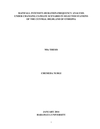
  • 43. 28 3. MATERIALS AND METHODS 3.1. Description of the Study Area The study was carried out in Addis Ababa, Fiche and Kachisi Meteorological Stations which are parts of central highland of Ethiopia. Central highland of Ethiopia is characterized by undulating topography and mountainous terrain. The highlands of Ethiopia are known as most intense population density and of greatest livestock density. The area is also known as the greatest land degradation. The Ethiopian highlands reclamation study (EHRS) concluded that water erosion (sheet and rill) was the most important process and erosion rates were estimated at 130 tons/ha/yr for cropland and 35 tons/ha/yr average for all land in the highlands (FAO, 1986). The current rate of deforestation is estimated at 62,000 ha/yr (World Bank 2001). Forests in general have shrunk from originally covering 65% of the country and 90% of the highlands to 16% and 20% in 1950s respectively. The forest coverage further reduced to 2.2% of the country and 5.6% of the highlands in 2000 (Leonard, 2003). Figure3.1. Location map of the study area The geographical locations of the meteorological stations are shown in Figure 3.1 and Table 3.1. Addis Ababa Meteorological Station (Tikur Anbesa National Observatory) is located at a longitude of 38.75o E, latitude of 9.02o N and altitude of 2386 masl. Fiche, the capital of north
  • 44. 29 Shewa zone of Oromia region is located at a longitude of 38.73o E, latitude of 9.77o N and altitude of 2784 masl on the main road from Addis Ababa to Bahirdar. Kachis, the capital of Gindeberet woreda is found in west Shewa zone of Oromia region, located at a longitude of 37.86o E, latitude of 9.61o N and altitude of 2557 masl. Table3. 1. Locations of Meteorological Stations No. Station Name Longitude ( 0 E ) Latitude ( 0 N ) Altitude (meters) Daily rainfall data Available Remarks 1 Addis Ababa (Tikur Anbesa) 38.75 9.02 2386 1970-2009 40 years 2 Fiche 38.73 9.77 2784 1986-2009 24 years 3 Kachisi 37.86 9.61 2557 1987-2009 23 years Source: National Meteorological Service Agency (NMSA) of Ethiopia. The rainfall pattern of central highland of Ethiopia experiences three seasons (tri-modal type) with two rainfall peaks (where one peak is more prominent than the other), a small peak in April and maximum peak in August (NMSA, 1996). The main rainy season (kremt) lies during the months of June to September and another rain (belg) during the months of March to May. The analysis of historical rainfall records (1970-2009 for Addis Ababa, 1986-2009 for Fiche and 1987-2009 for Kachisi) reveals that the mean monthly minimum and maximum rainfall of 8mm and 290.7mm, 7.6mm and 340.6mm and 15mm and 404.5 mm for Addis Ababa, Fiche and Kachisi respectively (Appendix Table 2) with annual mean rainfall of 1214, 1141.6 and 1787.7mm. The contributions of the seasonal rainfall for the stations are indicated in Table 3.2 below. The “kiremt” rain (JJAS) contributes more than 70% of the annual rainfall followed by “Belg” (MAM) which accounts for about 20%. July and August are the months with maximum annual rainfall for the study sites. The monthly variability of the rainfall of the study area is shown in Appendix Table 3. Table3.2. The rainfall pattern of the study area Station Mean Annual rainfall (mm) Seasonal Rainfall (mm) Seasonal Percentage (%) Belg (MAM) Kiremt (JJAS) Bega (ONDJF) Belg (MAM) Kiremt (JJAS) Bega (ONDJF) Addis Ababa 1214.0 239.3 864.1 110.6 20 71 9 Fiche 1141.6 180.6 869.9 91.0 16 76 8 Kachisi 1787.7 276.7 1335.2 175.8 15 75 10
  • 45. 30 3.2. Data Collection and Quality Control The rainfall data of the three stations (Addis Ababa, Fiche and Kachisi) were collected from National Meteorological Service Agency (NMSA) of Ethiopia. The stations were selected based on the assumptions that the stations are first class (automatic recording) with long years of rainfall data which were required for climate change study and minimum missing records. Global Circulation Model (GCM) data for the selected models were downloaded from www.pcmdi.llnl.gov/ipcc/about_ipcc.php website. 3.2.1. Filling missing data Only Kachisi station has a missing value for which only one neighbouring meteorological station (Harodoyo station) is available. Hence, normal ratio method (NR) was used to estimate the missing values. The missing value (P) was computed using the universal formula (Chow et al., 1988): (3.1) where, Wi is the weighted for the rainfall depth Pi, and Pi is rainfall at gauging i (neighbouring station/ Harodoyo). The weighting factor (wi) is computed by: (3.2) where, Ai is the average annual normal catch at gauging station i (neighbouring station), Ax is the average annual normal catch at station x (where data is missing) and n is the number of neighbouring stations. 3.2.2. Consistency of data Double mass curve method was used to carryout data quality analysis and to test the homogeneity of rainfall data. The mass curves for three of the stations were found to be nearly ∑ Wi
  • 46. 31 straight line (with R2 = 0.998 for Addis Ababa and R2 = 0.999 for Fiche and Kachisi) indicating the consistency of the data.(Appendix Figures 1-3). 3.3. Building Climate Change Scenarios for Rainfall 3.3.1. Climate Change Scenarios The climate change scenarios produced for this study were based on the outputs of GCM results that were established on the SRES emission scenarios. As the objective was to get indicative future climate ensembles, the scenarios were developed only for precipitation values. The rest of the climate variables were assumed to be constant. The outputs of HadCM3 GCM model for the A2 and B2 emission scenarios were used to produce the future scenarios. The SDSM was adopted to downscale the global scale outputs of the HadCM3 model into the study site scale. The future time scales from the year 2010 until 2099 were divided into three periods of 30 years and their respective changes were determined as percentages (for precipitation) difference from the base period values. The details of all the methodologies used are explained in the following sections. 3.3.2 General circulation model (GCM) Very recent GCMs are coupled models that include four principal components: atmosphere, ocean, land surface, and sea ice. The GCMs also make use the future forcing scenarios to produce the ranges of the climate change. These scenarios represent a set of assumptions about population growth, economic and technological development, and socio-political globalization. SRES recommends choosing among the following six emission scenarios: A1F1, A1T, A1B, A2, B1, and B2 (details were discussed in section 2.5.2). For this study among the different GCM models, HadCM3 (Hadley Centre for Climate prediction and Research, England) was used. Although, it is recommended to use the Ensemble of different GCM model output to minimize the uncertainties, however, in this study, due to limitations of time the output of only one GCM model (HadCM3) was used. The
  • 47. 32 model was selected because it was broadly functional in many climate change impact studies, and it provides large scale daily predictor variables which could be used for Statistical Downscaling Model (Wilby and Dawson, 2007).The model results were available for the A2 (medium-high emissions) and B2 (medium-low emission) emission scenarios and the results were used to produce the future scenarios. Moreover, the A2 and B2 emission scenarios may better represent the Ethiopia condition because it is in a medium range. For the two of these emission scenarios three ensemble members (a, b, and c) are available where each refer to different initial point of climate perturbation along the control run (Lijalem, 2006). Currently data for ensemble ‘a’ only were available at the Canadian climate research Centre therefore only A2a and B2a scenarios were considered in this study. 3.3.3. Statistical downscaling model (SDSM) Due to their very coarse resolution, GCM model outputs cannot be directly applied for impact studies at a watershed level. The temporal and spatial resolution disparity between the outputs of the GCM models and the data needed for such impact studies could be adjusted by using the so called “downscaling” technique (Palmer et al., 2004). SDSM Version 4.2, was used to downscale climate information from coarse resolution of GCMs to local or site level for rainfall scenario generation for the study area. The methods outlined by Lines and Barrow (2002) and that was described in the SDSM ‘User’s Manual’, which was downloaded from the SDSM website (http://www.aff.lboro.ac.uk/~cocwd/sdsm.html) was adopted. SDSM uses linear regression techniques between predictor and predictand to produce multiple realizations (ensembles) of synthetic daily weather sequences. The predictor variables provide daily information about large scale atmosphere condition, while the predictand describes the condition at the site scale. The SDSM software was used for data quality control, screening of predictor variables, model calibration, weather generation, statistical analysis, graphing model out puts and scenario generation.
  • 48. 33 3.3.3.1. Statistical downscaling model inputs The SDSM predictor data files were downloaded from the Canadian Institute for Climate Studies (CICS) website (http://www.cics.uvic.ca/scenarios/sdsm/select.cgi). Even though, there was a possibility of selecting predictors from different available GCMs like (HadCM3 and CGCM1), only the HadCM3 GCM data files were downloaded. The predictor variables of HadCM3 are provided on a grid box by grid box basis of size 2.5°N latitude x 3.75°E longitude (275km X 412km). For this study, the three meteorological stations completely fall in between 9.02°N to 9.77°N latitude and 37.86°E to 38.55°E longitude (Table 3.1). Hence, predictor variables in the nearest grid box whose centre is 10°N latitude and 37.5°E longitude represented by BOX_11X_31Y was downloaded for the HadCM3 GCM model data files, which represents the study area. Figure 3.2 The gird box for downloading predictor variables for the study area
  • 49. 34 3.3.3.2 Setting of the model parameter Year Length: For the observed and the NCEP data the year length was set to be the default 366 days), which allows 29 days in February in leap years. However, as HadCM3 have model years that do only consist of 360 days, the default value was changed to 360 days. Moreover, the default base period of the model (1/1/961 to 31/12/1990) was changed to 1/1/1970- 31/12/1999, 1/1/1986-31/12/2001 and 1/1/1987-31/12/2001 for Addis Ababa, Fiche and Kachisi stations respectively. Threshold Value: for daily precipitation calibration the parameter was fixed to 0.1 mm/day because the rainfall data of the stations were available to one decimal place. That means rainy days below this threshold value was traced as dry days. Variance Inflation: For the daily precipitation, the range of variation of the downscaled daily weather parameters can be controlled by fixing the variance inflation. This parameter changes the variance by adding/reducing the amount of “white noise” applied to regression model estimates of the local process. The default value, which is 12 produces approximately normal variance inflation (prior to any transformation). In calibrating the model the default variance inflation which is 12 was kept constant to compensate by the change in the bias correction. Bias Correction: Compensates for any tendency to over or under estimate the mean of conditional processes by the downscaling model (e.g., mean daily rainfall totals). The default value is 1.0, indicating no bias correction. The model was calibrated by varying the bias correction from zero to two. The process stops when the graph of the statistical parameters of the observed and the generated data have of the same pattern. 3.3.3.3. Predictor variables selection The first step in the downscaling procedure using SDSM is to set up the empirical relationships between the predictand variables (rainfall collected from stations) and the predictor variables obtained from the National Centre for Environmental Prediction (NCEP) re-analysis data for the current climate. Predictor variables selection involves the identification of appropriate predictor variables that have strong correlation with the predictand variable. This is the most challenging part of the work due to the temporal and
  • 50. 35 spatial variation of the explanatory power of each predictor (Wilby and Dawson 2007). The selection was done at most care as the behaviour of the climate scenario completely depends on the type of the predictors selected. Annual analysis period was used which provided the predictor-predictand relationship all along the months of the year. The parameter which tests the significance of the predictor predictand relationship, significance level, was set to be equal to the default value (p<0.05). Moreover, the process type that identifies the presence of an intermediate process in the predictor-predictand relationship was defined. For daily precipitation, because of its dependence on other intermediate process like on the occurrences of humidity, cloud cover, and/or wet-days; the conditional process was selected. Accordingly, identification of gridded predictors and single site predictands (observed data) was done using seasonal correlation analysis, partial correlation analysis, and scatterplots. Based on the criterion set for screening of appropriate predictors for the given site, of the twenty-six predictor variables derived from the NCEP reanalysis data sets, predictor variables that gave better correlation results at p<0.05 were chosen. As the strength of individual predictors often varies markedly on a month by month basis, personal judgment was also added in selecting the appropriate combination(s) of predictor(s) for a given season and predictand. 3.3.3.4. GCM model calibration, validation and weather generator The calibration process was carried out based on the outputs of the selection of the predictor variables that used the NCEP data base of the selected grid box. The mathematical relation between a specific predictand and the selected predictor variables was estimated and the parameters of a multiple linear regression equation were determined. The temporal resolution of the downscaling model was selected by choosing the model type (monthly, seasonal, or yearly). In Monthly models, model parameters were estimated for each month of the year. Hence, for this study, the calibration was done for the period of 20 years (1970-1989), 10 years (1986-95) and 10 years (1987-96) for Addis Ababa, Fiche and Kachisi respectively at a monthly model type in order to see the monthly temporal variations. The result of the weather
  • 51. 36 generator was used to validate the calibrated model using independent observed data not used during the calibration procedure. Accordingly the validation was done with the data from 1990-1999 (10 years), 1996-2001 (6 years) and 1997-2001 (5 years) for Addis Ababa, Fiche and Kachisi respectively. 3.3.3.5. Scenario generation SDSM has scenario generator which was used to downscale GCM (HadCM3) predictors in grid box containing the study area for the A2 and B2 SRES emission scenarios to the stations. Hence for this study, the HadCM3A2a and HadCM3B2a were the two GCM output files used for the scenario generation. Finally scenario was generated for rainfall predictand variables, both for base and future periods, using HadCM3 GCM model output for the two emission scenarios (A2 and B2 SRES emission scenarios) for the stations. The future scenarios was developed by dividing the future time series into three periods of 30 years the 2020s (2010- 2039), the 2050s (2040-2069), and the 2080s (2070-2099). The period from 1970-1999, 1986- 2001 and 1987-2001 were taken as a base period for Addis Ababa, Fiche and Kachisi stations respectively with which the comparison was made. Climate change scenarios were developed using SDSM to formulate the historic daily record at the three stations under study. The change fields for the climate change scenarios were computed using the SDSM outputs as the percent difference from the baseline case of monthly rainfall averaged for all years of output. The historic daily rainfalls at the three stations were modified by multiplying rainfall data with the monthly percentage change values previously obtained. This means that if the change field for the month of June is +10%, then all June values in the historic record are multiplied by 1.10; similarly, if the change field is -5% for the same month, all historic data is multiplied by 0.95 (Prodanovic and Simonovic, 2009). 3.4. Daily Rainfall Disaggregation Model The future climate will continue to change as the greenhouse gas concentrations is being altered in the atmosphere, ignoring any future change in greenhouse gas emissions. To
  • 52. 37 maintain seasonality in rainfall distribution, the downscaled daily rainfall outputs were proposed to be disaggregated into hourly values using the method of Hyetos Temporal Rainfall Disaggregation model. The Hyetos model require long time (at least 10 years) continuous record of rainfall intensity data of the sites for the estimation of parameters which would be used for disaggregating the daily rainfall into hours. However, for the study sites, the rainfall intensity data collected from National Meteorological Agency (NMA) had a lot of monthly and yearly missing values. Moreover, some of the existing rainfall intensity data were not the same with daily rainfall data both in amount and date. Hence, the Hyetos model could not be used. Consequently, the Rainfall Ratio Method (Equation 2.1) was adopted to convert 24hrs rainfalls into rainfall depths of different small durations’ required in constructing IDF curves. During calibration of the model, the value of n for the stations was found to be 0.87 which was used for the disaggregation of the daily rainfall into smaller hours. Hence value of n as 0.87 was used in this study. Figure 3.3 shows that there had been good relationship between the observed and disaggregated for 12hrs rainfall with correlation coefficient of 0.995. During calibration, the relationship obtained between observed and disaggregated rainfall at Addis Ababa station was indicated below (Table 3.3 and Figure 3.3). Table3.3 Relationship of observed and disaggregated rainfall at Addis Ababa station No Observed Disaggregated 6hr 12hr 24hr 6hrs 12hrs 24hrs 1 66.6 73.6 74.0 59.9 66.9 74.0 2 15.0 16.1 16.1 13.0 14.6 16.1 3 28.6 28.6 30.7 24.8 27.8 30.7 4 19.2 20.9 20.9 16.9 18.9 20.9 5 20.4 21.5 24.5 19.8 22.1 24.5 6 24.0 29.5 30.7 24.8 27.7 30.7 7 29.6 30.8 33.0 26.7 29.8 33.0 8 29.3 29.3 29.3 23.7 26.5 29.3 9 23.9 26.6 26.6 21.5 24.1 26.6 The disaggregated hourly rainfall data were next used to generate intensity duration frequency curves for the generated scenarios to create different realizations of future climate using different GCM responses. Finally, the annual maximum rainfalls for 1, 2, 3, 6, 12 and 24 hour durations was selected to fit to probability distribution function for calculating return periods.
  • 53. 38 Figure 3.3. Relationship between observed and disaggregated 12hr rainfall at Addis Ababa station. 3.5. Rainfall Intensity Duration Frequency Analysis The annual maximum rainfall data formulated by climate change scenario at the three stations were analysed using the method of frequency analysis and applying mathematical relationships. Data analysis and fitting the theoretical probability distribution to the observed data as well as numerical computation of the extreme rainfall magnitude (XT) were made for the required durations and frequencies based on the selected probability distribution function. The procedures and methods followed are outlined in the following subsections. 3.5.1. Fitting the probability distribution function The extracted annual maximum rainfall data were arranged in descending order to fit to the probability distribution functions. The maximum rainfall depths at the durations of 1, 2, 3, 6, 12 and 24 hours were fitted to Gumbel Extreme Value type I (EVI), lognormal and Log Pearson type III using frequency analysis techniques to select the best fitting model. The reason for selecting these distributions for analysis was due to the fact that they were being commonly used in rainfall and flood studies (Chowdhury et al., 1991; Vogel and McMartin, 1991 and Takara and Stedinger, 1994). 0 10 20 30 40 50 60 70 80 1 2 3 4 5 6 7 8 9 Rainfall(mm) Rainfall Records 12 hr Observed 12 hr Disaggregated
  • 54. 39 In fitting the data to the probability distributions, the most commonly used plotting position formula, the Weibull formula (Takara and Stedinger, 1994), was used to identify the best fitting probability distributions. The method of fitting the annual maximum rainfall data to the EVI, lognormal and Log Pearson Type III probability distributions are presented below. A. Fitting the data to Gumbel Extreme Value Type I (EVI) distribution function: This was achieved by plotting the rainfall data to the probability distribution function and YT (reduced variate) as abscissa. YT was calculated from the relationship given in Equation 2.9b. Weibull plotting positions was used in the computation. B. Fitting the data to lognormal distribution function: The standard normal variable, z, corresponding to the return periods of the ranked annual maximum rainfall was determined using equation 2.17 (Suresh, 2005; Bhakar et al., 2006; Adeboye and Alatise, 2007). Weibull plotting positions was used in the computation. C. Fitting the data to Log Pearson type III distribution function: To fit the data to Log Pearson type III distribution, the frequency factors, KT, corresponding to the annual maximum rainfall magnitude was determined using equation 2.21 (Adeboye and Alatise, 2007). Weibull plotting positions was used in the computation. 3.5.2. Testing the goodness of fit of data For each probability distribution (EVI, lognormal and log Pearson III) the chi-square goodness of fit test (equation 2.29) was used to see whether the data are fitting the theoretical frequency distributions for annual maximum rainfall values of all durations and stations under consideration.
  • 55. 40 3.5.3. Computation of extreme value (XT) For the computation of extreme values (XT) comparisons were made among the most common probability distributions for hydrological analysis (Gumbel’s extreme value type I, log normal and Log Pearson type III distributions) to select the best fitting one. Then once the probability distribution of the observed data was known, the extreme rainfall events (XT) for the selected return periods were estimated numerically. For instance, in the Log Pearson type III and Log normal distribution, the natural values of variate was converted into logarithmic form and the computations were performed (Haan, 1977; Suresh, 2005). The expected extreme rainfall (XT) exceeding the observed values were calculated by using Equation: XT = X + KTSy, (3.1) where XT is the reduced variate, X and Sy are the mean and standard deviation of data series, respectively, and KT is frequency factor. The selection of the return period for the design was based on the relative importance of the facility to be designed, cost (economics), desired level of protection, and damages resulting from a failure. The commonly used return periods as 2, 5, 10, 25, 50 and 100 years were considered in this study as suggested by Bhakar et al., (2006). 3.5.4. Calculation of intensity of rainfall The calculation of rainfall intensity was made by dividing the computed extreme rainfall value based on return period by the individual durations. Hence, intensity was calculated using the following expression: ιD ΤX (hr)durationΤime (mm)depthRainfall Ι  (3.2) where XT is extreme rainfall depth (mm) and Di duration (hr)
  • 56. 41 3.5.5. Estimation of intensity duration frequency curve coefficients Finally, using either extreme rainfall values (XT) or the intensity values (I) as inputs for the IDF Curve Fit Software (MIDUSS version 2.25) the IDF parameters (a, b and c) were estimated using Equation (3.3) as: C b)(d a Ι   (3.3) where I is rainfall intensity (mm/hr), d is rainfall duration (minute), a is coefficient with the same unit as I, b is time constant (minute) and c is an exponent usually less than 1. The IDF Curve Fit Software (MIDUSS version 2.25) manipulates data describing an Intensity-Duration-Frequency relation for a particular geographical location and used: i. To compute the ‘a’, ‘b’, and ‘c’ parameters that most closely approximates a set of observed rainfall data. ii. To compute the IDF curve for user-supplied values of the three coefficients and compare this with observed data. The value of the ‘a’ coefficient depends on the return interval in years of the storm and the system of units being used. The constant ‘b’ in minutes was used to make the log-log correlation as linear as possible. A value of zero for b parameter represents a special case of the IDF equation where poor agreement between observed values of intensity and duration are represented. The ‘c’ exponent is usually less than 1.0 and is obtained in the process of fitting the data to the power expression. Its values are usually in the range of 0.75 to 1.0. 3.5.6. Parameter performance testing The coefficient of determinations R2 and Nash and Sutcliffe simulation efficiency ENS were used for performance testing between the computed and observed intensities were calculated using equations (2.30 and 2.31).