1. Chapter 2. STUDY AREAS, SAMPLING AND STATISTICAL
METHODS
2.1 STUDY AREA - GENERAL DESCRIPTION
This section is based on working plans for the Rhenosterhoek forest area and
Mauchsberg forest area of "MONDI"-Forests (L.t.d) and S.A.F.I (L.t.d.). The
Rhenosterhoek area comprising the Blyfstaanhoogte and Rhenosterhoek plantations,
and the Mauchsberg area comprising the In Die Diepte and Grootfontein plantations.
Climatic data were obtained form the provincial statistics database (CSS, 1995).
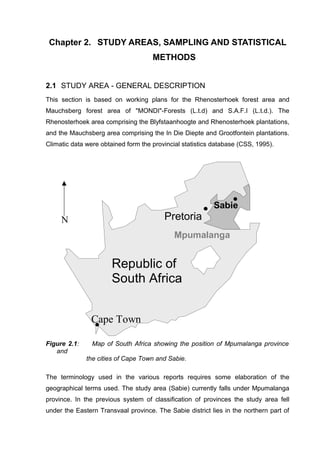
Figure 2.1: Map of South Africa showing the position of Mpumalanga province
and
the cities of Cape Town and Sabie.
The terminology used in the various reports requires some elaboration of the
geographical terms used. The study area (Sabie) currently falls under Mpumalanga
province. In the previous system of classification of provinces the study area fell
under the Eastern Transvaal province. The Sabie district lies in the northern part of
Sabie
Pretoria
Cape Town
Mpumalanga
Republic of
South Africa
N
2. the Mpumalanga province and the city of Sabie is the district capital (Figure 2.1).
Detailed descriptions of the sampling sites are presented in Appendix A.
2.1.1 Climate
The study area falls within the semi-humid subtropical summer rainfall zone (October
to April). The average number of rainy days is 90 (C.S.S., 1995). The rain ranges
from heavy downpours to light penetrating showers. An appreciable amount of rain
falls in the form of gentle drizzle and mist, which is typical of the area, hence the
name “the mist belt” given to the area. The Grootfontein area is described (S.A.F.I.,
1973) as not being typically “mist belt”. In the rainy season (summer), the soil is
permanently well supplied with moisture, which, under summer conditions, seldom
rises by capillary forces to the surface. Moreover, during the rainy season
precipitation exceeds evaporation. In winter (dry season), there is little rain and the
drying-out of the soil is accelerated by strong dry winds.
The data presented in Table 2.1 refer to the years 1961-1990. Indicated are the
annual mean rainfall and the maximum and minimum temperatures recorded in the
Eastern Transvaal-Mpumalanga region (C.S.S., 1995).
Table 2.1 : Temperatures and rainfall for the period of 1961-1990 ( C.S.S., 1995).
Annual January July Annual January July
Rainfall (mm) Temperature (°C)
Mean
Nelspruit 767 127 10 19.9 24 14.8
Witrivier 687 102 14 21.1 24.8 16.7
Mpumalanga
Minimum 516 80 1 13.7 17.3 8
Maximum 1480 264 21 22.2 25.7 17.2
Table 2.1 shows the considerable rainfall variation over Mpumalanga province. The
average rainfall ranges from 500mm/a to almost 1500mm/a. Rabie et al. (1994) cite a
h lower precipitation limit of 750 mm/acre for commercial forestry. Mondi-Forests
(1997) cite a lower precipitation limit for softwood commercial plantation of >900
mm/a. Also important in this context are the maximum rainfall figures. These are for
the Graskop area which includes the Mauchsberg plantations. The Mauchsberg area
is distinguished by its higher rainfalll in comparison with the surrounding terrain in
3. Mpumalanga. Optimum growth temperatures are reported to be between 15 and
30°C (Rundel et al., 1998). The vegetation is typical of dolomite and shale ground
(S.A.F.I., 1957), mainly grasslands (short and long grass) on hilly terrain. Trees are
found along the valleys and mountain tops.
2.1.2 General geological and mineralogical background
The geological description of the area under study is based on the South African
Geological Survey - S.A.C.S. (1980), and of reports produced by S.A.F.I (1957,
1973, 1979) regarding specific plantations. Where discrepancies occur between the
SACS survey (1980) and SAFI reports (1957, 1973, 1979), the SACS description
was preferred.
The area studied falls under the lithostratigraphic subdivision of the Transvaal
sequence and the Pretoria group (SACS, 1980). The Pretoria group consists
predominantly of quartzite and shale with a dominant volcanic unit, the Hekpoort
andesitic formation. Minor conglomerates, chemical and volcanic members are also
found.
Nowicki (1997) gives the clay content of the shales in forest soils of the Eastern
Escarpment as being between 20 and 30%. The mineralogy of the clay was
described by Nowicki (1997) as consisting mainly of kaolinite. Chlorite, gibbsite and
goethite were also reported.
2.2 RHENOSTERHOEK FOREST AREA
The Rhenosterhoek forest area consists of the following plantations: Rhenosterhoek,
Doornhoek and Blyfstaanhoogte. Afforestation at the Rhenosterhoek plantation was
commenced in 1944, at k in 1949 and at Blyfstaanhoogte in 1957. The
Rhenosterhoek plantation is 2127 hectares in extent and the Blyfstaanhoogte
plantation 3075 hectares. The plantations from which the samples were taken are
described below.
2.2.1 Topography
Situated 30°35’E and 25°13’S, the forest area lies at the foothills of the Drakensberg
4. range in the Eastern Transvaal escarpment area. The elevation is between 1400 to
2200m above sea level. The area comprises of two main drainage basins - the
Nelspruit river and the Blyfstaanspruit river, both of which are part of the Crocodile
river catchment area. On the northern and the western part of the Rhenosterhoek
forest area, the topography is one of steep slopes levelling off towards the south-
east. The topographical features of the area are typical of the Eastern Transvaal.
The terrain consists of irregular undulating gentle slopes, but becomes steep towards
the northern, eastern and western boundaries, which run along the summits of the
ridges.
2.2.2 Geology and soils
The underlying bedrocks are predominantly dolomite, shale, and occasional quartzite
of the Transvaal sequence with intrusions of diabasic dykes and sills in all three
bedrocks (Figure 2.2). The stratigraphic sequence dips to the west with the dolomite
overlying quartzite of the Black Reef formation. The dolomitic terrain is deeply
dissected with underground aquifers (S.A.F.I., 1957).
Shales of the basal Pretoria Group overly the dolomites. The soils derived from the
shale are predominantly clay loam. On the plateau, the soils are shallow to moderate
in depth. The depth to the unweathered bedrock of the shale zone is reported to be
10-15 m (S.A.F.I., 1957), in the Rhenosterhoek-Doorenhoek area, and 600-700m in
the Blyfstaanhoogte area (S.A.F.I., 1979). The shale in the Blyfstaanhoogte area is
described as thinly bedded brown shale, very fissile in parts. The colour is slightly
darker in the lower portions. Bands of micaceous, shaley sandstones are common
throughout the area. The shale is generally highly jointed, and in some places highly
ferruginous (S.A.C.S, 1980).
The soils of the area studied are typical of the “Mistbelt” and are derived from
shale and quartzite of the Pretoria Group. The soils in the Rhenosterhoek plantation
were described (S.A.F.I., 1957) as comprising mainly a sandy loam and sandy clay.
The soil texture of the Blyfstaanhoogte plantation was described as being a sandy
loam- clay loam. Both plantations were reported (S.A.F.I., 1957) to be of low pH (4.4
-
5. Figure 2.2: Sampling sites and the Basic geology of the Sabie area.
4.9, in water suspension), adequate levels of nitrogen in the A and B mineral
horizons as well as low P and K (Appendix A). The soil is acidic (esp. in the upper
horizons) with a tendency towards nutrient depletion (N,P,K) as the profile deepens
(S.A.F.I., 1957).
Blyfstaanhoogte
ANDESITE
SHALE
DOLOMITE
GRANITE
Sabie
Graskop
Rhenosterhoek
In Die Diepte
Blyfstaanhoogte
- Sampling site
Grootfontein
km100
Klipkraal
6. 2.2.3 Sampling sites
Eleven compartments were sampled. Six samples were taken from the
Rhenosterhoek plantation (Appendix A) and five from the Blyfstaanhoogte plantation
(Appendix A). The samples were labelled in a sequence specific for this study. The
conversion of the official compartment identification to that used in this study is
presented in Table 2.2.
2.3 GROOTFONTEIN FOREST AREA
The Grootfontein forest area is part of the Mauchsberg forest plantation area, and
consists of the Grootfontein and Die Diepte plantations (Appendix A). The
terminology used in characterising the area in the various reports and maps is not
very consistent. This is attributable to changes in forest management and reporting
policies over the years. The terminology needs to be tidied up.. Prior to 1978, the
Grootfontein forest area comprised a single plantation: Grootfontein. From 1978
onwards, the references are to Grootfontein as including the Grootfontein plantation
and In Die Diepte plantation. In this study the forest area will be referred to as
Mauchsberg area and the two plantations will be referred to by their name i.e.
Grootfontein and In Die Diepte. As regards for the history of afforestation in this
area, commercial planting commenced in Grootfontein in 1948 and in In Die Diepte in
1959.
2.3.1 Topography
The Mauchsberg forest area is situated behind the first range of hills west of the
Drakensberg mountain range, and incorporates a portion of the Blyde river canyon.
The approximate geographical location is 30°45’E and 24°25’S. The topography of
the plantation is rugged with steep, broken slopes, deep gorges and very little flat
land. The plantation is bisected, roughly from South to North by the Blyde river with
minor tributaries emerging from cliffs and running in all directions. The altitude varies
from 1830 m above sea level in the South east corner, to 1280 m at the Blyde river in
the north of the forest area. The mountain slopes face predominantly east and west.
7. Table 2.2 : Site description - Rhenosterhoek forest area.
Plantation Compar-
tment
No.
Sample
labelling
Year
established
Comp-
artment
age (y)
Present
rotation
No.
Pinus
species
Rhenosterhoek R-13 R-1 1946 52 2 pat+ell
R-15a R-2 1946 52 2 pat+ell
R-22 R-3 1947 51 3 Elliottii
R-23c R-4 1945 53 3 Elliottii
R-23d R-5 1945 53 2 Patula
R-24 R-6 1945 53 2 Patula
Blyfstaanhoogte M-27a B-1 1958 40 2 Patula
M-47a B-2 1976 22 1 pat+ell
M-48b B-3 1976 22 1 Patula
N-3b B-4 1960 38 2 Patula
M-35a B-5 1959 29 2 Patula
pat -patula ; ell - elliottii
2.3.2 Geology and soils
The geological nature of this area is similar to that of the Rhenosterhoek area.
Sediments of the Transvaal Group underlie most of the area of the study. The soils
derived from these rock types vary in depth. In the lower slopes, they are deep, rich
and of dolomitic origin while on the higher areas the soils are shallow and poorer in
respect to nutrients and are predominantly after shale.
2.3.3 Sampling sites
Ten compartments were sampled. Seven samples were taken from the In Die Diepte
plantation and three from the Grootfontein plantation (Appendix A). The site
description is presented in Table 2.3.
Table 2.3: Site description - Mauchsberg forest area.
Plantation Compar-
tment
Sample
labelling
Year
established
Compart
-ment
Present
rotation
Pinus
species
8. No. age (y) No.
Grootfontein A-3a G-1 1949 49 2 pat+ell
A-3b G-2 1950 48 2 pat+ell
E-3a G-3 1955 43 2 taeda
In Die Diepte L-1 I-1 1966 32 2 taeda
M-20 I-2 1970 28 2 pat+ell
M-22 I-3 1969 29 2 patula
N-15 I-4 1972 26 1 elliottii
N-16 I-5 1972 26 2 elliottii
J-20 I-6 1964 34 2 patula
P-4b I-7 1973 25 1 patula
pat -patula ; ell - elliottii
2.4 KLIPKRAAL FOREST
The oldest site available for sampling was near MONDI's dam in the Klipkraal
plantation (10km north east to Sabie). The plantation was established in 1931. The
sampled compartment (R-15b) was never harvested, and the trees on this site are
still of the first rotation (67 years of age). The geology of the site is predominantly
granitic. It is of a western aspect and is some 400m lower than the average sampled
site in the Rhenosterhoek and Mauchsberg forest area.
2.5 SAMPLING METHODS
Soil sampling was carried out at suitable sites where the pine plantations were:
• Facing a North-West to North-East aspect.
• Similar parent material (shale).
• Varied slopes.
• High altitude (1500-2000m).
• Maximum available spread of plantation age.
Twenty-two sites were selected to represent similar geological and geographical
properties, with plantation age ranging between 22 to 67 years. One exception is a
pine plantation chosen for its progressive age (67 years) in view of its slightly
different characteristics (granitic parent material, western slope, lower altitude). All
9. sites were sampled within a time span of 48 hrs. No substantial change in climate
liable to affect soil properties was noted during the sampling period. The data and
records of the various plantations and compartments were collected from “Mondi”
regional offices in Sabie. The records were used to decide which of the
compartments were to be sampled, and to obtain data regarding the history of each
of the compartments.
Only topsoils were sampled for this study (0-20 cm). Any overlying organic material
was removed. The reasoning for this was the assumption that most of the root mass
(and root surface) responsible for water and nutrient uptake are in the topsoil (de
Vries, 1991). In addition, it is the topsoil that is most sensitive to acid deposition, and
thus most likely to reflect any change in the chemistry of the solid and aqueous
phases in forest soils. Given the silvicultural and different littering manners in the
various pine species, the organic horizon was not sampled and was excluded from
the samples. A composite soil sample was created according to the following
method:
A sampling site, with an average size of 200*200m was selected. Four individual soil
samples were obtained by removal of the upper organic horizon. A hole, 20-25cm
deep and 25cm wide was dug. The soil was mixed in the hole and excavated. The
four individual samples were consolidated, thoroughly mixed and a composite
sample was taken (3-4 kg).
The samples were air-dried, sieved (2mm) and stored for further analysis. The soil
samples were analysed by common methods of soil analysis. The main objective
was characterising the chemistry of the exchangeable phase and the soil solution. All
of the analytical work reported in this study was carried out on these 22 samples.
2.6 STATISTICAL TREATMENT
The relationship between the soil chemical properties of pine plantations and age of
these soils under commercial forestry is statistically evaluated by using a non-
parametric, one way anova test (Kruskal- Wallace). The reasoning behind the use of
this statistical treatment is the number of samples (22) and the ability to evaluate the
10. data while disregarding the distribution of the parent population. In this study, for
most variables, the data is not normally distributed. The assessment of a statistical
treatment is done by obtaining the p-values which provides an indication as to
whether the result is statistically significant or not (commonly a 95% confidence limit
is used, i.e. p≤0.05).
Precision of the various methods used for the chemical analysis of the soil samples is
evaluated by using mean, variance and standard deviation based on descriptive
statistics. Relationship between various parameters (such as Ca/Al ratio and Age of
afforestation) is obtained by using non-parametric treatments such as Shapiro-Wilks
test for determining the distribution and obtaining trend lines (using Spearman r2
criterion). All the statistical calculations are carried out using the STATISTICA
software program (StatSoft Inc., 1995).