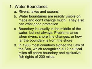
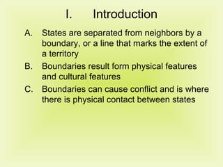
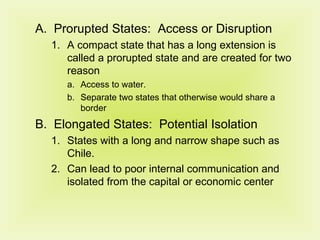
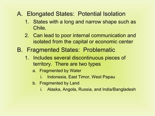
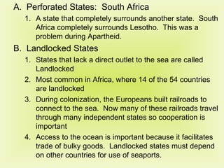
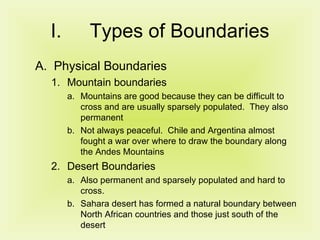
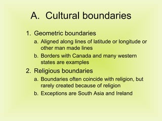
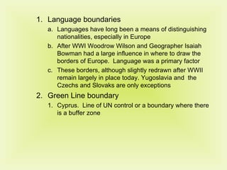
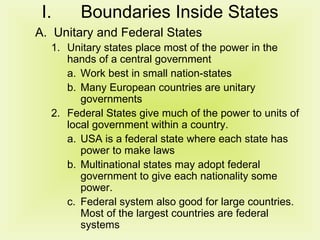
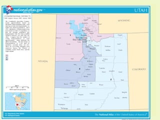
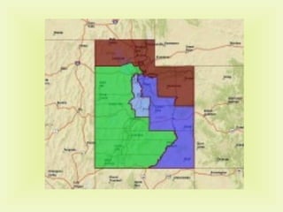
Chapter 8, Key 2 Why Boundaries Cause Problems
Introduction States are separated from neighbors by a boundary, or a line that marks the extent of a territory Boundaries result form physical features and cultural features Boundaries can cause conflict and is where there is physical contact between states
Shapes of States Compact States:  Efficient where the distance from the center of the state to any boundary does not vary much Good for smaller states for communication. Burundi, Rwanda, Uganda are examples Does not guarantee peace.  Can still have ethnic conflicts and civil wars
Prorupted States:  Access or Disruption A compact state that has a long extension is called a prorupted state and are created for two reason Access to water.  Separate two states that otherwise would share a border Elongated States:  Potential Isolation States with a long and narrow shape such as Chile. Can lead to poor internal communication and isolated from the capital or economic center
Elongated States:  Potential Isolation States with a long and narrow shape such as Chile. Can lead to poor internal communication and isolated from the capital or economic center Fragmented States:  Problematic Includes several discontinuous pieces of territory.  There are two types Fragmented by Water Indonesia, East Timor, West Papau Fragmented by Land Alaska, Angola, Russia, and India/Bangladesh
Perforated States:  South Africa A state that completely surrounds another state.  South Africa completely surrounds Lesotho.  This was a problem during Apartheid. Landlocked States States that lack a direct outlet to the sea are called Landlocked Most common in Africa, where 14 of the 54 countries are landlocked During colonization, the Europeans built railroads to connect to the sea.  Now many of these railroads travel through many independent states so cooperation is important Access to the ocean is important because it facilitates trade of bulky goods.  Landlocked states must depend on other countries for use of seaports.
Types of Boundaries Physical Boundaries Mountain boundaries  Mountains are good because they can be difficult to cross and are usually sparsely populated.  They also permanent Not always peaceful.  Chile and Argentina almost fought a war over where to draw the boundary along the Andes Mountains Desert Boundaries Also permanent and sparsely populated and hard to cross. Sahara desert has formed a natural boundary between North African countries and those just south of the desert
Water Boundaries Rivers, lakes and oceans Water boundaries are readily visible on maps and don’t change much.  They also can offer good protection. Boundary is usually in the middle of the water, but not always. Problems arise when rivers, shore line changes, or how far the boundary is from the shore In 1983 most countries signed the Law of the Sea, which recognized a 12 nautical miles off shore boundary and exclusive fish rights of 200 miles.
Cultural boundaries Geometric boundaries Aligned along lines of latitude or longitude or other man made lines Borders with Canada and many western states are examples Religious boundaries Boundaries often coincide with religion, but rarely created because of religion Exceptions are South Asia and Ireland
Language boundaries Languages have long been a means of distinguishing nationalities, especially in Europe After WWI Woodrow Wilson and Geographer Isaiah Bowman had a large influence in where to draw the borders of Europe.  Language was a primary factor These borders, although slightly redrawn after WWII remain largely in place today. Yugoslavia and  the Czechs and Slovaks are only exceptions  Green Line boundary Cyprus.  Line of UN control or a boundary where there is a buffer zone
Boundaries Inside States Unitary and Federal States Unitary states place most of the power in the hands of a central government Work best in small nation-states Many European countries are unitary governments Federal States give much of the power to units of local government within a country. USA is a federal state where each state has power to make laws Multinational states may adopt federal government to give each nationality some power. Federal system also good for large countries.  Most of the largest countries are federal systems
Trend Toward Federal government There is a current trend of states moving from unitary to federal governments France: Curbing a unitary government A Nation-State with a tradition of Unitary  Government Divided into Departments and further into communes In recent years the national government has given more and more power to the departments and the communes
Poland: A new Federal government Poland switched to a federal government after communism fell in order to do away with the communist legal structure. They created new local governments and held elections, but faced problems because new leaders lacked experience and people rejected old leaders because of their communist ties
Electoral Geography Gerrymandering Boundaries of electoral regions in the United States and other countries are redrawn from time to time In Europe they are redrawn by independent commissions, in the United States they are redrawn by state legislatures. The political power in charge will redraw the boundaries for the purpose of benefiting their party.  This is called Gerrymandering
Types of Gerrymandering Wasted vote spreads opposition votes across many districts Excess votes concentrates opposition supporters into a few districts Stacked Votes links distant areas of like-minded voters through oddly shaped boundaries. “ Stacked Vote” Gerrymandering Recently most gerrymandering in the USA has been stacked vote Has been used to create districts inclined to elect ethnic minorities and separate them from other voters Gerrymandering has made most of the US congressional seats non-competitive so shift in power doesn’t happen often.


Ch 8 key 2

  • 1.
    Chapter 8, Key2 Why Boundaries Cause Problems
  • 2.
    Introduction States areseparated from neighbors by a boundary, or a line that marks the extent of a territory Boundaries result form physical features and cultural features Boundaries can cause conflict and is where there is physical contact between states
  • 3.
    Shapes of StatesCompact States: Efficient where the distance from the center of the state to any boundary does not vary much Good for smaller states for communication. Burundi, Rwanda, Uganda are examples Does not guarantee peace. Can still have ethnic conflicts and civil wars
  • 4.
    Prorupted States: Access or Disruption A compact state that has a long extension is called a prorupted state and are created for two reason Access to water. Separate two states that otherwise would share a border Elongated States: Potential Isolation States with a long and narrow shape such as Chile. Can lead to poor internal communication and isolated from the capital or economic center
  • 5.
    Elongated States: Potential Isolation States with a long and narrow shape such as Chile. Can lead to poor internal communication and isolated from the capital or economic center Fragmented States: Problematic Includes several discontinuous pieces of territory. There are two types Fragmented by Water Indonesia, East Timor, West Papau Fragmented by Land Alaska, Angola, Russia, and India/Bangladesh
  • 6.
    Perforated States: South Africa A state that completely surrounds another state. South Africa completely surrounds Lesotho. This was a problem during Apartheid. Landlocked States States that lack a direct outlet to the sea are called Landlocked Most common in Africa, where 14 of the 54 countries are landlocked During colonization, the Europeans built railroads to connect to the sea. Now many of these railroads travel through many independent states so cooperation is important Access to the ocean is important because it facilitates trade of bulky goods. Landlocked states must depend on other countries for use of seaports.
  • 7.
    Types of BoundariesPhysical Boundaries Mountain boundaries Mountains are good because they can be difficult to cross and are usually sparsely populated. They also permanent Not always peaceful. Chile and Argentina almost fought a war over where to draw the boundary along the Andes Mountains Desert Boundaries Also permanent and sparsely populated and hard to cross. Sahara desert has formed a natural boundary between North African countries and those just south of the desert
  • 8.
    Water Boundaries Rivers,lakes and oceans Water boundaries are readily visible on maps and don’t change much. They also can offer good protection. Boundary is usually in the middle of the water, but not always. Problems arise when rivers, shore line changes, or how far the boundary is from the shore In 1983 most countries signed the Law of the Sea, which recognized a 12 nautical miles off shore boundary and exclusive fish rights of 200 miles.
  • 9.
    Cultural boundaries Geometricboundaries Aligned along lines of latitude or longitude or other man made lines Borders with Canada and many western states are examples Religious boundaries Boundaries often coincide with religion, but rarely created because of religion Exceptions are South Asia and Ireland
  • 10.
    Language boundaries Languageshave long been a means of distinguishing nationalities, especially in Europe After WWI Woodrow Wilson and Geographer Isaiah Bowman had a large influence in where to draw the borders of Europe. Language was a primary factor These borders, although slightly redrawn after WWII remain largely in place today. Yugoslavia and the Czechs and Slovaks are only exceptions Green Line boundary Cyprus. Line of UN control or a boundary where there is a buffer zone
  • 11.
    Boundaries Inside StatesUnitary and Federal States Unitary states place most of the power in the hands of a central government Work best in small nation-states Many European countries are unitary governments Federal States give much of the power to units of local government within a country. USA is a federal state where each state has power to make laws Multinational states may adopt federal government to give each nationality some power. Federal system also good for large countries. Most of the largest countries are federal systems
  • 12.
    Trend Toward Federalgovernment There is a current trend of states moving from unitary to federal governments France: Curbing a unitary government A Nation-State with a tradition of Unitary Government Divided into Departments and further into communes In recent years the national government has given more and more power to the departments and the communes
  • 13.
    Poland: A newFederal government Poland switched to a federal government after communism fell in order to do away with the communist legal structure. They created new local governments and held elections, but faced problems because new leaders lacked experience and people rejected old leaders because of their communist ties
  • 14.
    Electoral Geography GerrymanderingBoundaries of electoral regions in the United States and other countries are redrawn from time to time In Europe they are redrawn by independent commissions, in the United States they are redrawn by state legislatures. The political power in charge will redraw the boundaries for the purpose of benefiting their party. This is called Gerrymandering
  • 15.
    Types of GerrymanderingWasted vote spreads opposition votes across many districts Excess votes concentrates opposition supporters into a few districts Stacked Votes links distant areas of like-minded voters through oddly shaped boundaries. “ Stacked Vote” Gerrymandering Recently most gerrymandering in the USA has been stacked vote Has been used to create districts inclined to elect ethnic minorities and separate them from other voters Gerrymandering has made most of the US congressional seats non-competitive so shift in power doesn’t happen often.
  • 16.
  • 17.