This document provides a summary of the history of Brooklyn Centre from 1812 to 2012. It describes how Brooklyn was first settled in 1812 along an American Indian trail and how the Township of Brooklyn was established in 1818. By the mid-1800s, Brooklyn had become a self-sufficient village. In 1894, it was annexed by Cleveland and developed rapidly with new infrastructure improvements. The document highlights some of the early settlers and families, architectural styles of historic homes, and transportation routes that shaped the development of Brooklyn Centre over the past 200 years.
The document summarizes important African American historical sites in Brooklyn, New York. It describes locations such as the first property purchased by an African American in Brooklyn (41 Hicks St), several Colored Schools established in the 1800s, churches like Bridge Street African Wesleyan Methodist Episcopal Church that were stops on the Underground Railroad, and community organizations like the Weeksville Society that works to preserve the historic Weeksville neighborhood.
2011 Parma Heights Walking Tour Update With Maps 6 And Do Not Copy Watermark ...kennethlavelle
The document summarizes a walking tour of Parma Heights, Ohio that highlights several historical sites and structures along the route, including:
1) The Tollgate House replica, which commemorates the original tollgate along the Brooklyn & Parma Plank Toll Road.
2) A bust of George Washington in front of the library and a time capsule placed there in 1976.
3) Several other stops highlighting the Eternal Flame monument, the route of an abandoned railroad, and the Ohio Historical Marker designating the first rural brick road in the U.S.
4) Local churches, schools, and other structures that show the area's history of settlement and development.
The document provides an 18-day itinerary for a summer tour around Lake Michigan from July 25 to August 11, 2002. The tour included visits to museums, historic sites, and campgrounds in Pennsylvania, West Virginia, Ohio, Indiana, Illinois, Wisconsin, and Michigan. Highlights included touring Oglebay Park and museums in Wheeling, WV, visiting historic villages and canal boats in Ohio, and museums relating to presidents and railroads in various Midwestern cities along the route.
Parma Heights Centennial Master Slides For Short Small 20 Minute Version Man...kennethlavelle
The document provides a presentation on the history of Parma Heights, Ohio from 1810 to 2011, covering topics such as local political authorities, mayors, roads, landmarks, and population figures. It discusses the transition from Parma Township to the villages of Parma and Parma Heights and highlights important historical sites along Wooster Pike, including houses, barns, churches, and schools from the early 1800s.
The document summarizes the presentation made by the Historic Preservation Committee to the City of College Station about awarding local historic markers. It discusses the mission to preserve local history, provides an overview of the marker program awarding 93 residential and 9 business markers to date, and highlights specific residential markers being awarded for the Whitley House, Merchant House, Searcy House, and Baker-Wilson House, as well as business markers for St. Matthew Baptist Church and Pleasant Grove Baptist Church.
The work of three historians — Mary MacKenzie, Lee Manchester and Janet Null — has been combined in this survey of the historic architecture of Main Street, Lake Placid, in the heart of New York's Adirondacks. Rich in both current and archival photographs, the book includes a section of comparative streetscape images, placing full-page archival shots side-by-side with current views of the Olympic Village. TO PURCHASE A BOUND, PRINTED EDITION, GO TO http://stores.lulu.com/marymackenzie
The Burton Street Community in Asheville, NC was founded in 1912 by civic leader E.W. Pearson as one of the first African-American neighborhoods in the city. It was initially seen as a rural area with farms and livestock. Pearson had a profound impact through his civil rights work and establishing the annual Buncombe County agricultural fair. The neighborhood school was a focal point of the community until closing in the 1970s, after which the neighborhood began to decline due to abandoned homes and drug issues. In recent years funding has supported revitalization efforts including renovating the community center and implementing traffic calming measures.
This document provides a historical overview of the Minooka and Channahon areas from their earliest inhabitants to the early 20th century. It notes that the areas were originally home to Native American tribes like the Illiniwek, Potawatomi, and Mound Builders. French explorers first visited in 1673. White settlers arrived in the late 1820s and the villages of Minooka, Channahon, and Dresden were established. The coming of the railroad in 1852 and the Illinois & Michigan Canal in the 1840s boosted development and trade of local agriculture. Early buildings, churches, and infrastructure are described from the mid-19th century founding of the towns.
The document provides a timeline of notable events and developments in Lincoln Park located in College Heights, Rock Island, Illinois from 1821 to 1960. It outlines the founding and early additions to the park in the early 20th century. It then discusses two major turning points - the establishment of Alleman High School in 1949 which provided a Catholic alternative to public schools, and individuals like F.C. Denkmann and Naomi Davenport who made significant donations to further develop the park and neighborhood. Paired images show the developments and changes over time to the park, surrounding areas, and Alleman High School building.
Since becoming a state in 1789, North Carolina has seen many changes in transportation, population, land use, and technology:
(1) Advances in transportation like steamboats, railroads, automobiles, and airplanes transformed how people and goods moved around the state and connected NC to the rest of the country;
(2) These transportation changes, along with improvements in health and sanitation, led to rapid population growth and the rise of cities and mill towns;
(3) As more people moved to cities, farm land decreased and was replaced by urban and industrial development;
(4) Revolutionary technologies like the telegraph, telephone, radio, and television revolutionized communication and increased global awareness, while
The document provides details of a 21-day, 4,174 mile road trip through the Heartland region of the United States from May 27 to June 16, 1996. It includes an itinerary with stops in 13 states, highlighting attractions visited and overnight camping locations. Journal entries describe sights seen in cities like Cumberland, MD, Charleston, WV, Louisville and Frankfort, KY, Dodge City, KS, Colorado Springs and Denver, CO, as well as state capitol buildings toured along the way.
Arlington, Texas has a long history as an entertainment destination, beginning with horse racing at Arlington Downs Racetrack in the 1930s. Today, it is home to major attractions like Six Flags Over Texas, The Ballpark in Arlington, and Cowboys Stadium. Traces of Arlington's entertainment past can still be seen, such as the decorative water trough that is all that remains of the old racetrack, located near Six Flags Drive. Arlington continues to build on its identity as a top spot for fun and leisure activities in the state.
The work of three historians — Mary MacKenzie, Lee Manchester and Janet Null — has been combined in this survey of the historic architecture of Main Street, Lake Placid, in the heart of New York's Adirondacks. Rich in both current and archival photographs, the book includes a section of comparative streetscape images, placing full-page archival shots side-by-side with current views of the Olympic Village. TO PURCHASE A BOUND, PRINTED EDITION, GO TO http://stores.lulu.com/marymackenzie
This document provides a summary of a 31-day, 7,693 mile summer tour through the Northwest United States and Canada in 1998. It describes visits to various historic sites, museums, and national parks along the route, including locations related to Abraham Lincoln in Illinois, Native American and frontier history sites in the Dakotas and Montana, and cultural attractions in Minnesota, Manitoba, and Ontario.
Burk Run/St Clair Terrace. A unique nature-culture weave in Euclid, Ohio. At the Euclid-Wickliffe line, Burk Run cuts north through the Painesville Moraine to cross Euclid Ave. The stream then flows north on the St. Clair Terrace.
In 1797, Joseph Burk opened an inn on the Euclid side of the run. Girdled Rd (1800) & the Bishop Mill (1809) attracted settlers. Inns opened in Wickliffe.
In 1881, the Nickel Plate Railroad set the stage for area vineyards and a brickyard. Wickliffe’s brick downtown grew quickly, as did Noble in Euclid.
Post WWII growth killed local industry & railroading. In 1961, I-90 buried Burk Run and sucked manufacturing and settlement from the area.
The Burk Run tour explores the stream's cut through the St Clair Terrace and asks, “Can we restore this stream?”
For 2016, Cleveland Heights Rocks and Waters walks Quilliams Creek, a major tributary of Nine Mile Creek within the city.
On sidewalks and forest paths, we follow Quilliams on its course to join Nine Mile.
Walk through the local geology, ecology and history of this important bluestone landscape.
Nine Mile Creek is a new member of the Cuyahoga River Area of Concern for watershed restoration. We’ll also discuss stream restoration issues.
Make a Mobile Website Quickly and Easily with WinkSiteJohn Allan
This document provides instructions for creating a mobile website about Niagara Falls using WinkSite. It describes the steps to set up categories or channels for nature, history and tourism and add pages with information about Canadian Falls, American Falls and the future of Niagara Falls. The instructions guide the user to organize content before starting, then outline 55 steps to build the site including adding images, channels, pages and apps.
The document summarizes the histories of several churches in and around Westhoughton, Lancashire, England. It discusses when the churches were established, rebuilt, or expanded. Several highlights include:
- St Bartholomew's Church in Westhoughton dates back to at least 1200 AD and was rebuilt in 1731 and 1869. It burned down in 1990 but was replaced in 1995.
- St John's Church in Wingates dates to 1859 and the hymn "Angel Voices Ever Singing" was composed for its first pipe organ dedication in 1861.
- St James' Church in Daisy Hill was built in 1881 and donated by local residents. It is considered an architectural gem designed by famous architects P
Burk Run/Hillandale. A unique nature-culture weave in Euclid, Ohio. At the Euclid-Wickliffe line, Burk Run cuts north through the Painesville Moraine to cross Euclid Ave.
In 1847, the Isaac E. Brush family built a substantial Greek Revival house. Charles Franklin Brush was born here.
In 1898, J.R. Outhwaite built Hillandale in Euclid. J.E.French built Nutwood in Wickliffe.
In 1910, Nela Park developer, Burton Tremaine, bought Hillandale. He quickly built the log house and, later, the Hillandale bridge.
Current owners of ~80 acres of ecologically significant land include the Providence Missionary Baptist Church and the City of Euclid.
The Burk Run Hillandale tour explores the stream's cut through the Painesville Moraine and possibilities for conserving the area a Euclid Escarpment Ravine Preserve.
Bucktown dates back to the 1800s before Chicago was established. It was originally settled by Polish goat herders in the 1830s and later German immigrants in the 1840s. After the Chicago Fire of 1871, residents moved from the city to Bucktown. The population is currently around 13,000 with a median age of 32 and median household income of $80,974. There are several public transportation options to access Bucktown from Loyola including the CTA Red and Blue lines or various bus routes. Popular attractions in the area include music venues, art galleries, theaters, and the annual Wicker Park Fest.
Mission Hall - Lenswood & Forest Range history displaylfrlh
The document summarizes the history of the Mission Hall in Forest Range, South Australia from 1909-1934. It describes how in 1910, local residents led by the Anglican minister Rev Everett decided to build a community hall for Anglican worship, social events, and entertainment. Mr JB Fry donated land for the building. The hall was constructed from 1913-1914 with contributions from the community. It was opened in 1914 by Lady Bosanquet and served the community for religious, social, and entertainment purposes for many years.
In Cleveland Heights, Ohio, follow Dugway Brook West Branch as it cuts through the Berea Sandstone and Euclid bluestone layers of the Portage Escarpment. Trace a glacial meltwater channel from Edgehill Rd, northward through Coventry to Lake View Cemetery. At seven stops, see how early settlers established mills and quarries and, later, cemeteries and schools. Learn the natural base for suburban development. Comprehend the issues for stream conservation around the NEORSD flood control dam at Lake View Cemetery.
The Redstone Run Highland Reserve comprises 8 acres at 25309 Highland Rd, Richmond Heights. Here, the stream cuts through the hard Euclid bluestone to create a small gorge in the softer shale below. The reserve conserves local nature and history. With it, the Friends of Euclid Creek can foster education and research on important watershed issues. Join us, Tuesday, May 6, 6:30 pm for a tour of the reserve with presentations by Roy Larick, Al Klonowski and Claire Posius.
to explore and plan.
Doan Brook Parks explores park landscape in the hand of natural and human forces. Find evidence for the rise of local bedrock, for bulldozing glacial ice and for Doan Brook’s cutting of a beloved ravine.Review the impacts of park development, including the outstanding Cleveland Cultural Gardens. See the recently completed Doan Brook Enhancement Project in terms of stormwater mediation and the restoration of local natural habitats.
Emmer Green is a suburb of Reading located north of Caversham. It has a history of rural mansions that have been converted for other uses. Housing development increased rapidly after World War II, though some efforts have been made to preserve open spaces. There are two primary schools and one secondary school that serve Emmer Green. Other landmarks include St. Barnabas Church and an extensive abandoned chalk mine.
For 2016, Cleveland Heights Rocks and Waters walks Quilliams Creek, a major tributary of Nine Mile Creek within the city.
On sidewalks and forest paths, we follow Quilliams on its course to join Nine Mile.
Walk through the local geology, ecology and history of this important bluestone landscape.
Nine Mile Creek is a new member of the Cuyahoga River Area of Concern for watershed restoration. We’ll also discuss stream restoration issues.
The Lenswood Memorial Park was established in 1946 when local residents raised funds to purchase land to create a community park. It was officially opened in 1949 and facilities like tennis courts and an oval were developed. Over subsequent decades more amenities were added through fundraising and grants, including a hall, playground, and pavilion. By the 1990s a new toilet block had been built and the hall upgraded, celebrating the park's role in bringing the community together for over 50 years.
The Trowbridge Civic Centre redevelopment project was completed on time and on budget. It provided 4,500 square meters of new flexible space for offices, performance areas, meeting rooms, and other community spaces. Materials for the building included local chestnut, stone, steel, and brick. The redevelopment replaced an outdated 1970s building and improved energy efficiency through high insulation, low energy lighting, underfloor heating, and natural ventilation.
The document discusses city squares and compares Nathan Phillips Square in Toronto to the Mississauga Civic Centre square. It notes that city squares typically include features like walkways, benches, fountains, sculptures, and are surrounded by buildings. They are places for people to gather, relax, eat, watch people and events. While Nathan Phillips Square attracts many people, the Mississauga Civic Centre square seems empty and unused. The document suggests opportunities to activate underused public spaces.
The document discusses proposals for civic centers in different locations. It summarizes the key elements and purposes of civic centers. Civic centers are intended to serve as the administrative and cultural hub for a community, containing government offices, convention spaces, recreational facilities, and open spaces. The proposals aim to make these centers accessible, sustainable, and iconic landmarks that bring people together and support the community.
This document discusses the justification for designing a recreation club in Thane, India. It outlines several benefits of recreational sports such as improved physical and mental health, reduced crime rates, and positive social and educational outcomes. Regular physical activity is important for preventing diseases and lowering healthcare costs. Recreation allows people to reduce stress and interact with others, while children benefit from teamwork and developing skills through sports. The document argues that investing in recreation facilities supports public health and development in communities.
The document proposes establishing a Sharda Recreational Activity Center (SRC) at Sharda University. The 50,000 square foot SRC would include facilities like a gymnasium, fitness areas, swimming pool, jogging track, and sports clubs. It is estimated to cost 10 million rupees. Establishing the SRC would benefit students by lowering stress, attracting more students to the university, and generating membership fee revenue.
FINAL B.ARCH THESIS PRESENTATION IIT ROORKEE:
City Centre ,Rohini ,Delhi ,Thesis project (2013)
A Mixed use development project comprises of diverse activities and functions located at the
sprawling District centre in Rohini with site area of 16 acres.With a AIM to explore the symbiotic
character of COMMERCE and CULTURE and to evolve a contemporary model of conventional
Indian market.
Quaker burial ground cork street; a resource listkieran rose
The document provides an extensive resource list on the history of the Quaker Burial Ground on Cork Street in Dublin, Ireland. It details the burial ground's current neglected state and ownership issues. It then outlines the Quakers' historical role in the Liberties area from the 17th century, including merchant Anthony Sharp who established the burial ground. Finally, it lists numerous related sources that discuss the Quakers' urban planning contributions and links between properties around the burial ground.
This document provides an update on Larry Roeder's history project documenting the area of Conklin and Prosperity Baptist Church in Loudoun County, Virginia. It summarizes the early settlement of Conklin by both white and African American pioneers in the 18th century. It details Roeder's efforts to collect oral histories, photos, artifacts and records to preserve the history of prominent African American families like the Allens who lived in the area. The document outlines the boundaries of traditional Conklin and calls for help from community members to share their stories and knowledge to aid the project.
The Friends of Lincoln Village organization was formed in 2007 to preserve historic sites around Lincoln University, the first historically black college in the US founded in 1854. The organization has been working to get Lincoln University and Lincoln Village designated as a historic district on the National Register of Historic Places. This would recognize their significance in African American history and education. Goals include hiring a preservation planner, updating the National Register nomination, and stabilizing historic buildings. Over 65 people attended an initial historic tour of the campus organized by the group. The Friends of Lincoln Village will continue working to secure the needed resources to have the historic designation completed.
This document provides a summary of off-the-beaten path locations in Brooklyn and Manhattan. It discusses notable facts about Brooklyn, including its status as one of the largest cities if separate. It then highlights various neighborhoods, parks, and sites worth visiting, such as Prospect Park, Green-Wood Cemetery, Brooklyn Botanic Garden, and the Lower East Side Tenement Museum. The document aims to showcase interesting and historic areas beyond the typical tourist destinations.
This document provides a summary of 5 postcards from a US-36 roadtrip from Ohio to Colorado. It describes points of interest along the route such as clay workings in Uhrichsville, Ohio and Zane Shawnee Caverns in Ohio. It also discusses places related to US presidents like Rutherford B. Hayes' birthplace in Delaware, Ohio and sites involving Abraham Lincoln in Illinois. Further locations mentioned include Hannibal, Missouri known for its connection to Mark Twain, and landmarks in Denver, Colorado at the route's end.
The document provides information about Bannack, Montana as a potential filming location to represent Inverness in a film adaptation of Macbeth. Bannack is an old, abandoned gold mining town that resembles the descriptions of the depleted village of Inverness in the Macbeth script. The document describes the layout and buildings of Bannack, including the wooden chapel and central pavilion, and notes that crosses mark the graves on the outskirts of the village, matching details from the Inverness descriptions. Overall, the document argues that Bannack's eerie atmosphere as a forgotten town makes it a suitable stand-in for the setting of Inverness in the script.
QUAKER BURIAL GROUND CORK STREET HOW TO RESTORE, COMMEMORATE, AND CELEBRATE ...kieran rose
QUAKER BURIAL GROUND CORK STREET Dublin 8
HOW TO RESTORE, COMMEMORATE, AND CELEBRATE A HISTORIC PLACE, A PART OF OUR CULTURAL HERITAGE: SUMMARY
“It is a peaceable place to visit”
My Great Great Grandmother Maria Christina, Great Great Grandfather George Conrad and their 'Baby Butz' are buried at Block 8, Lot 85. Their daughter and my Great Grandmother Susanna Katharina and Great Grandfather Johann Balthasar are buried at Block 13, Lot 262. Because I have family at this historic cemetery, we plan to participate in the Friends Society. Visit: http://friendsofriversidecemetery.org/
Brooklyn Heights is a historic neighborhood in Brooklyn that was selected as one of America's most beautiful neighborhoods. It has maintained a small town feel despite its proximity to Manhattan. The neighborhood is known for its architectural beauty, parks along the East River with views of Manhattan, and historic sites like Plymouth Church. Brooklyn Heights has convenient subway access and remains a popular residential area of Brooklyn.
The document summarizes a group's trip to the Ukrainian Village neighborhood in Chicago. It provides background on the history and demographics of the area, which began as a farming community settled by Ukrainian immigrants in the late 19th century. It then details the group's journey to the neighborhood by public transit, including stops at the Holy Trinity Orthodox Cathedral and Ukrainian National Museum. Finally, it discusses some of the local cuisine, including restaurants and Black Dog Gelato.
Walk the Doan Brook gorge from MLK to Ambler Park. Here, we learn the natural base for Cleveland's early suburban development, 1890s-1910s. Comprehend the issues for stream conservation. Supported with a grant from Cuyahoga Arts & Culture, 2014.
This PowerPoint presentation was developed for Elkhart Community Schools. The target audience is third grade, but it can be used by a wide range of ages, including adults.
The Ukrainian Village neighborhood in Chicago has a population of 35,726 residents within an area of 2.133 square miles. The median household income is $66,485 and 20.4% of residents are foreign born. Four mass immigrations from Ukraine between 1870-1990s established the cultural presence of Ukrainians in the area. Churches and organizations were built to preserve Ukrainian culture and religion. Popular locations today include Shokolad Pastry and Café and Sts. Volodymyr and Olha Ukrainian Catholic Church, a center of the community.
This document summarizes a group's trip to the Ukrainian Village neighborhood in Chicago. It first provides some background on the history and demographics of the area, noting that it was originally a farming area settled by Ukrainian immigrants in the late 1800s/early 1900s. It then describes the group's journey there by public transit, including some struggles they encountered. Finally, it outlines some of the architectural and cultural sights they saw, such as historic housing styles, churches, a Ukrainian museum, and restaurants serving both Ukrainian and other cuisines.
The Ukrainian Village neighborhood is located on the west and near west sides of Chicago. It has a population of over 52,000 people, with over 15,000 Ukrainian immigrants. The area was originally settled in the late 19th century by Ukrainian immigrants and became a center of the Ukrainian community in Chicago. It remains a middle-class area with many Ukrainian churches, shops, and the Ukrainian National Museum of History that celebrate the area's cultural history.
Great neighborhoods are often anchored by great places. These are distinctive places that add identity and character to a neighborhood or district. This report, created by the Cleveland City Planning Commission, (http://planning.city.cleveland.oh.us), seeks to identify and celebrate some of the great places, large and small, in Cleveland and its neighborhoods.
The document provides a detailed history of two horse racing tracks that existed in Brooklyn, Ohio from the 1840s through the 1920s:
1) The first Brooklyn Driving Park was established in 1849 and was privately owned, hosting early harness racing. Very little documentation remains about its early existence. A second track was established in 1923 at the same location.
2) In 1926, the closed Brooklyn Driving Park re-opened for an 18-day thoroughbred horse racing event after the Cuyahoga County Sheriff allowed racetracks to operate, despite betting being illegal in Ohio. Hundreds of horses were transported between tracks for the event.
3) Questions remain about the ownership and operations of the
The Ukrainian Village neighborhood has a population of 52,131 people with a median age of 30.76. It is located on the west side of downtown Chicago. Beginning in the 1870s, many Ukrainians immigrated to the area, settling near existing Polish communities. Today, the neighborhood retains an Eastern European character and contains numerous sites of historic and cultural significance, including the Holy Trinity Orthodox Cathedral built in 1906. The median household income of $65,393 is 11% lower than the city of Chicago overall.
The Ukrainian Village neighborhood is located on the west and near west sides of Chicago. It has a population of 52,131 people with a median household income of $61,375. Originally settled by Ukrainian immigrants in the late 19th century, it remains an ethnically Ukrainian area with many attractions related to Ukrainian culture, such as Sts. Volodymyr and Olha Ukrainian Catholic Church, the Ukrainian National Museum of History, and several Ukrainian-owned businesses.
KALYAN MATKA | MATKA RESULT | KALYAN MATKA TIPS | SATTA MATKA | MATKA.COM | MATKA PANA JODI TODAY | BATTA SATKA | MATKA PATTI JODI NUMBER | MATKA RESULTS | MATKA CHART | MATKA JODI | SATTA COM | FULL RATE GAME | MATKA GAME | MATKA WAPKA | ALL MATKA RESULT LIVE ONLINE | MATKA RESULT | KALYAN MATKA RESULT | DPBOSS MATKA 143 | MAIN MATKA
The cherry: beauty, softness, its heart-shaped plastic has inspired artists since Antiquity. Cherries and strawberries were considered the fruits of paradise and thus represented the souls of men.
❼❷⓿❺❻❷❽❷❼❽ Dpboss Matka ! Fix Satta Matka ! Matka Result ! Matka Guessing ! Final Matka ! Matka Result ! Dpboss Matka ! Matka Guessing ! Satta Matta Matka 143 ! Kalyan Matka ! Satta Matka Fast Result ! Kalyan Matka Guessing ! Dpboss Matka Guessing ! Satta 143 ! Kalyan Chart ! Kalyan final ! Satta guessing ! Matka tips ! Matka 143 ! India Matka ! Matka 420 ! matka Mumbai ! Satta chart ! Indian Satta ! Satta King ! Satta 143 ! Satta batta ! Satta मटका ! Satta chart ! Matka 143 ! Matka Satta ! India Matka ! Indian Satta Matka ! Final ank
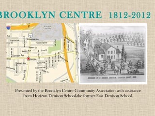
1. BROOKLYN CENTRE 1812-2012
Presented by the Brooklyn Centre Community Association with assistance
from Horizon Denison School-the former East Denison School.
2. Early Settlement
• Brooklyn was settled in 1812 along an American
Indian trail that broke off of the Lake Trail and followed
the current alignment of Pearl Road until reaching the
ridge edge of the prehistoric Lake Whittelsey.
• The Township of Brooklyn was established in
1818. By 1830, Brooklyn Centre was a small trading post
for the largely rural township and by a generation later, it
had grown into a hamlet with merchandising,
manufacturing, trade and a residential area for Cleveland
business people and industrialists.
• By the time the Civil War ended in 1865,
Brooklyn had become a self sufficient village with its own
school system, fire department and constable.
• In 1894, the village was annexed by the City of
Cleveland, after which the neighborhood developed
rapidly, spurred by new civic improvements such as paved
streets with utility lines, and the extension of police and
fire protection into Brooklyn Centre.
SEE: http://
www.nps.gov/nr/travel/ohioeriecanal/bro.htm
3. Resources
Many of the images and content for this slide presentation have been compiled
using collections found at Cleveland Public Library, the
Cleveland Memory Collection, the Brooklyn Centre Wiki, and the
National Park Service.
4. Brooklyn Centre Photos at Cleveland Public Library
The George Ketteringham Collection consists of materials that Ruth
Ketteringham collected over the many years that she researched Brooklyn-
Centre and other areas of Cleveland, Ohio.
Ruth Ketteringham (1906-2006), daughter of George
Ketteringham, was devoted to preserving the history of the area. Her
research was extensive and allowed her the ability to lecture on various
aspects of Brooklyn-Centre.
Ruth was the recipient of the Herrick Memorial Award in 1990.
An honor awarded by the Early Settler's Association to individuals who have
promoted and brought honor to Cleveland.
Upon Ruth's death at the age of 99 in 2006, her books were donated to
the Cleveland Public Library's History Department; four or five file cabinet's
worth of papers were donated to the Western Reserve Historical Society and
two boxes of material were saved from the trash by the Brooklyn Centre
Community Association.
5. Brooklyn Centre Historic District
The neighborhood achieved the status of Historic District on May 7, 1984,
with a formal dedication ceremony held on May 20, 1984 at Archwood
United Church of Christ.
The Brooklyn Centre neighborhood is home to many landmarks of historic
note including cemeteries, fire station, medical buildings, residences,
commercial buildings and churches.
The above photo shows Italianate Mallo House (1904), which is now the office
of the Donahue Foot Clinic on West 25th St.
It includes one of the oldest structures in the neighborhood with the back
portion of the house dating to 1857.
6. Masonic Hall - 3800 West 25th St., Cleveland, Ohio
(while under construction in 1932 Architect Daniel Farnum-EXTANT)
Fraternal Orders like the Free Masons and
Grand Army of the Republic were important to the early
settlement
7. Grand Army of the Republic (GAR) Hall – community meeting
place and, for a time, the location of the public library.
3797-99 West 25th St., Cleveland Ohio - Brooklyn Post #368-demolished
8. Grand Army of the Republic Hall - 3797-99 West 25th St., Cleveland, Ohio
(appears in the background of this Masonic Hall dedication photo)
9. Lake at Riverside Cemetery —
Drained before 1918. The cemetery was founded in 1876 from land that was settled as a farmstead
by Titus Brainard.
(Source: http://csudigitalhumanities.org/exhibits/items/show/2502)
10. The two tributaries to the Cuyahoga River still flow under the cemetery buried
in culvert
12. Water and Transportation
--Lake Erie
Cuyahoga
River and tributaries
--Historic Indian
Trails
/Crossroads
/Pearl &
Denison
--Horse and
Buggy
/Railroad
/Canal
/Streetcars
--Auto/Bus
Highway
Note: this map shows neighborhood as Brooklyn Centre /Bikes
of Brooklyn Township
13. Farming and Homesteads
The first families to settle Brooklyn Township relied on neighbors and community for
food, wood and necessities-first families include the names FISH, FOSTER, and
BRAINARD.
Brooklyn Township, the land west of the Cuyahoga River,
was known as the Lord and Barber allotment.
– All settlers would have purchased their land from Samuel P. Lord and Josiah
Barber.
The first permanent white settler of Brooklyn was James Fish.
Brooklyn Centre consists of two of the main lots
, #65 and #74, as surveyed and marked
out for the Western Reserve.
Early settlers of Brooklyn Centre were brothers,
Ebenezer and Moses Fish
on lot #65
and Ozias Brainard on lot #74.
Stearns Farm in Parma Township (later City of Parma) provides a great present day window into the world o
14. First Families in Brooklyn Centre
Text from brass historic marker archived at
Cleveland Public Library-formerly on cornerstone
of Brooklyn Branch Library 3706 Pearl Rd.
Cleveland OH 44109:
Brooklyn Centre
James Fish arrived in this area with his
family from Connecticut in 1811, making
them Cleveland’s first white settlers west
of the Cuyahoga River. Fish built his
first home on this site, a log cabin of
hand-hewn logs in 1812. On May 9,
1814, his fifth child, Isaiah, was born
here. He was the first non-Indian child
to be born on the west side of the river.
The fish family’s first permanent frame
home was built just west of the log cabin.
It housed the first schoolroom in the
area.
15. Burial Grounds—Scranton, Riverside
and Denison Cemetery
As part of the Connecticut New Western Reserve, James Fish was the first
permanent white settler in the territory that became Brooklyn …William
Gannon Rose stated in the 1812 section of his book that the Fish Family
burial lot became the first public cemetery west of the Cuyahoga River.
James deeded it to the trustees of a school district. (This should have been
School District No. 2, and the deed was not found, but there is a deed from
Ebenezer Fish to the school district No. 9 which would be the old Brooklyn
Burial Ground, now Denison Cemetery, in 1835.) p.1
The plot in the rear of the vault was donated in the year 1819, by James Fish, to
the North Brooklyn Township, for the burial of indigent people of School
District #2.
Source: Scranton Road Cemetery, Cleveland, Ohio Introduction, Inscriptions
and Interments by Cynthia Turk (2004.)
16. Early Architectural Styles
Many of the first homes built in Brooklyn Centre can still be found on A
Annexed to Cleveland near the end of the 19th century, Brooklyn Centre underwent rapid
growth that continued through 1915. The Brooklyn Centre Historic District, which was
designated in 1984 includes many homes from the turn-of-the-century with most homes
constructed between 1910-1920.
17. Brooklyn Centre Historic District
Above walking tour was compiled by Historian Craig Bobby in 2004—see Brooklyn Centre Wiki and
Brooklyn Centre Community Association for more information on current streets and homes.
19. There are a number of reminders of the past in
Brooklyn Centre—carriage house garages for
horse-drawn carriages. The Fire Station on
West 25th has a hayloft that can be seen on the
back side of the building. There are walk-up
churches like the above Good News Church
which started out as Ammaus Evangelical
Lutheran, and served German immigrants who
made up the neighborhood in 1912-when the
church was built.
20. Glazed brick house 3400 Mapledale
above was built by Snow family next
to location of their first house shown
at upper right (bric-brac is gone
today). Bliss-Fish family house also
on Mapledale was relocated from
original location at corner of Pearl
Rd. to accommodate construction of
the Third Church of Christ.
21. Origin of Brooklyn Center/Centre Neighborhood
designation?
This early Cleveland planning document shows entry to Brooklyn Township
settlement at intersection of Pearl and Broadview—which never materialized.
1874 Township maps show all centers of townships as “Centre”-see Dover Centre
etc.
22. Highway Construction
Construction of Interstate-71 and
I-176, the Jennings Freeway,
destroyed a number of historic
structures on the historically
German north side of
Brooklyn Centre and in the
Polish Catholic St. Barbara
parish neighborhood of
Brooklyn Centre, known as
Barbarowa. Photo left shows
Kohl house- which still exists
and has been restored on
Library Ave.
23. Brooklyn Centre-2012
Brooklyn Centre grew from a sleepy rural township to a bustling commercial crossroads with
the streetcar era. In the fifties, as highways accelerated the move to the suburbs, the
neighborhood declined and was rediscovered again in the nineties. Population shifts have
always made this a neighborhood of immigrants. After American Indians lost this
territory, immigrants from Connecticut and the Western Reserve settled here, followed by
waves of German immigrants during the Industrial Revolution and later Poles and other
Eastern European immigrants working in the steel mills and other industries along the
Cuyahoga River.
Today, you are more likely to hear Spanish or an African language as new residents
settle from Central America and African countries. But, Brooklyn Centre will
continue to welcome New Americans and will always be a neighborhood built
on memories that celebrate our blended cultural heritage.