1. J.Kartheeswari / International Journal of Engineering Research and Applications
(IJERA) ISSN: 2248-9622 www.ijera.com
Vol. 2, Issue 4, July-August 2012, pp.385-389
Implementation Of Location Monitoring Services Based On
Anonymization Algorithm
J.Kartheeswari
Centre For Information Technology And Engineering, M S University, Tirunelveli
ABSTRACT
Anonymization algorithm is mainly sensors and counting sensors. In identity sensor
used to monitor the location . In this paper location monitoring system, the sensor nodes report
propose an implementation of location the exact location information of the monitored
monitoring services based on resource and persons to the server. While counting sensor
quality aware algorithm. In resource aware monitoring system, each sensor node reports the
algorithm to minimize time and communication number of objects in its sensing area to the server.
cost. In existing system to find the minimum We propose two anonymization algorithm namely
bounding rectangle using monitor area. In our Resource-aware and Quality-aware algorithm. In
paper another way to find the minimum Resource aware algorithm to minimize
bounding rectangle using monitor object. While communication cost. In quality aware algorithm to
finding the minimum founding rectangle with provide accurate location.
monitor object and monitor area we find that
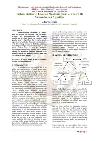
the time to process is equal. II. SYSTEM ARCHITECTURE
Keywords – Wireless sensor networks, Location Server admin
privacy, Aggregate location
Aggregate
I. INTRODUCTION Set anonymity
location info
In wireless sensor network (WSN) is an value
ad-hoc network composed of small sensor nodes
deployed in large numbers to sense the physical
Sensor Node Sensor Node
world. Wireless sensor networks have very broad
application prospects including both military and
civilian usage. In mobile sensor network Query Location
development of algorithms and prototype vehicles update
for wide-area surveillance and reconnaissance
using mobile sensor networks (MWSN). User User User User
Monitoring on land, water and air using large
numbers of mobile sensor nodes is demonstrated at
our Distributed Intelligence and Autonomy Lab Sensor Nodes: Each sensor node is responsible for
(DIAL). Mobile sensor networks are sensor determining the number of objects in its sensing
networks in which nodes can move under their own area. Sensor nodes blurs its sensing area into a
control or under the control of the environment. cloaked area, which includes at least k objects, and
Mobile networked systems combine the most reports with the number of objects located in
advanced concepts in perception, communication, particular region as an aggregate location
and control to create computational systems information to the server. Each sensor node is also
capable of interacting in meaningful ways with the aware of its location and sensing area.
physical environment, thus extending the individual
capabilities of each network component and Server: Server collects the aggregate locations
network user to encompass a much wider area and reported from the sensor nodes, using a spatial
range of data. A key difference between a mobile histogram to estimate the distribution of the
sensor network and a static sensor network is how monitored objects. Also server answers range
information is distributed over the network. Under queries raised by users, based on the estimated
static nodes, a new task or data can be flooded object distribution. Administrator can change the
across the network in a very predictable way. anonymized level k of the system at anytime by
Under mobility this kind of flooding is more disseminating a message with a new value of k to
complex. Under natural mobility this depends on all the sensor nodes.
the mobility model of the nodes in the system. For
the location monitoring system using identity Users: Each and every user updates their location
information to the sensor node. Users can issue
385 | P a g e
2. J.Kartheeswari / International Journal of Engineering Research and Applications
(IJERA) ISSN: 2248-9622 www.ijera.com
Vol. 2, Issue 4, July-August 2012, pp.385-389
range queries to the system through the sensor of objects located in its sensing area m.count, to its
nodes. They can get reply for query like, what is neighbors. When m receives a message from a peer
the number of persons in a certain area? The server p, m stores the message in its PeerList. Whenever
uses the spatial histogram to answer their queries. m finds an adequate number of objects, m sends a
notification message to its neighbors. If m has not
Privacy model: Sensor nodes constitute a trusted received the notification message, some neighbors
zone, communicate with each other through a has not found an adequate number of objects,
secure network channel to avoid internal network therefore m forwards the received message to its
attacks, for example, eavesdropping, traffic neighbors.
analysis, and malicious nodes. The system provides
anonymous communication between the sensor 3.2 Cloaked Area Step
nodes and the server by employing existing Cloaked area step is that each sensor node
anonymous communication techniques. Thus given blurs its sensing area into a cloaked area that
an aggregate location R, the server only knows that includes alteast k objects to satisfy the k-anonymity
the sender of R is one of the sensor nodes within R. privacy requirement. To minimize computational
Authenticated administrators can change the k- cost, this step uses a greedy approach to find a
anonymity level. Administrators can set the k- cloaked area based on the information stored in
anonymity level to a small value to get more PeerList.
accurate aggregate locations from the sensor nodes, 3.2.1 Score
or even set it to zero to disable the algorithm to get The score is defined as a ratio of the
the original readings from the sensor nodes, in object count of the peer to the euclidean distance
order to get the best services from the system. This between the peer and m. The idea behind the score
is a nice privacy-preserving feature, because the is to select a set of peers from PeerList to S to form
object count of a small area is more likely to reveal a cloaked area that includes at least k objects and
personal location information. The definition of a has an area as small as possible. Then, we
small area is relative to the required anonymity repeatedly select the peer with the highest score
level, because our system provides lower quality from the PeerList to S until S contains at least k
services for the same area if the anonymized level objects
gets stricter.
Aggregate Location: Each sensor node blurs its
sensing area into a cloaked area, in which at least k
persons are residing. Each sensor node reports only
aggregate location information, which is in a form
of a cloaked area A, along with the number of
persons, N, located in A, where N ≥ k, to the
server. A smaller k indicates less privacy
protection, because a smaller cloaked area will be
reported from the sensor node; hence better
monitoring services. A larger k results in a larger
cloaked area, which will reduce the quality of
monitoring services, but it provides better privacy
protection.
III. RESOURCE AWARE ALGORITHM Figure 2. Resource aware cloaked area of
Resource aware algorithm indicates that sensor A
the sensor nodes can communicate directly with
each other. This algorithm consists of three steps. Figure 2. illustrates the cloaked area step.
The PeerList of sensor node A contains the
3.1 Broadcast Step information of three peers, B, D, and E. The object
Broadcast step is to guarantee that each count of sensor nodes B, D, and E is 3, 1, and 2,
sensor node knows an adequate number of objects respectively. We assume that the distance from
to compute a cloaked area. To reduce sensor node A to sensor nodes B, D, and E is 17,
communication cost, this step relies on a heuristic 18, and 16, respectively. The score of B, D, and E
that a sensor node only forwards its received is 3/17 = 0:18,1/18 =0:06, and 2/16 = 0:13,
messages to its neighbors when some of them have respectively. Since B has the highest score, we
not yet found an adequate number of objects. select B. The sum of the object counts of A and B
In this step, after each sensor node m is six which is larger than the required anonymity
initializes an empty list PeerList, m sends a with its level k = 5, so we return the MBR of the sensing
identity m.ID, sensing area m.Area, and the number area of the sensor nodes in S, i.e., A and B, as the
386 | P a g e
3. J.Kartheeswari / International Journal of Engineering Research and Applications
(IJERA) ISSN: 2248-9622 www.ijera.com
Vol. 2, Issue 4, July-August 2012, pp.385-389
resource-aware cloaked area of A, which is rectangle. In existing system to find the minimum
represented by a dotted rectangle. bounding rectangle using monitor area. In our
3.2.2 Minimum Bounding Rectangle paper another way to find the minimum bounding
For each sensor node initializes in its rectangle using monitor object.
PeerList. It includes atleast k-objects and has an
area as small as possible. Finally, m determines the
cloaked area that is a minimum bounding
rectangle(MBR) that covers the sensing area of the
nodes, and the total number of objects. An MBR is
a rectangle with the minimum area that completely
contains all desired regions.
3.3 Validation Step
In validation step is to avoid reporting
aggregate locations with a relationship to server
Each sensor node maintains a list to store the
aggregate locations sent by other peers. AS this
step ensures that no aggregate location with the
containment relationship is reported to the server, Figure 3. Quality aware cloaked area of
the adversary cannot obtain any deterministic sensor A
information from the aggregate locations. Since the Figure 3 illustrate the area of MBR
server receives an aggregate location from each
sensor node for every reporting period, it cannot A, E is less than current minimal cloaked area
tell whether any containment relationship takes and the total number of monitored objects in MBR
place among the actual aggregate locations of the A, E is k= 5, we set A, Eto the current
sensor nodes. minimal cloaked area
4.2.1 Monotonicity property
IV QUALITY AWARE ALGORITHM This property propose two pruning
The Quality-aware algorithm initializes a conditions in the lattice structure. 1. If the
variable current minimal cloaked area. When the combination gives the current minimal cloaked
algorithm terminates, the current minimal cloaked area, other combinations that contains at the higher
area contains the set of sensor nodes. This levels of the lattice structureshould be pruned. 2. If
algorithm consists of three steps. a combination constitutes a cloaked area that is the
same or larger than the current minimal cloaked
4.1 Search Space Step area, other combinations that contain at the higher
The search space step is too costly for levels of the lattice structure should be pruned.
node m to gather the information of all the sensor
nodes to compute its minimal cloaked area. To 4.3 Validation Step
reduce communication and computational cost, m This step is exactly the same as in the
determines a search space based on the input initial resource-aware algorithm.
solution. It is to compute the minimal cloaked area.
V IMPLEMENTATION
4.2 Minimal Cloaked Area Step In this application, we try to implement
Minimal cloaked area takes a set of peers location monitoring system. We use MS access as
in search space, computes the minimal cloaked area database for this application. We are going to
for the sensor node. It propose two optimization develop a location monitoring system, where user
techniques to reduce computational cost. The first updates their location to server through sensor
optimization technique is that need not to examine node. Sensor node cloaks the exact location of
all the combinations of the peers. This optimization client to region coverage range, thus the privacy of
mainly reduces computational cost by reducing the the user can be preserved. Also more privacy can
number of computations among the peers. The be achieved by using k-anonymity value, which can
second optimization technique has two properties be set by admin. More the value of k-anonymity
1. Lattice Structure means more privacy for users. The users in
2. Monotonicity Property particular region can rise query to server about the
4.2.1 Lattice structure: number of users in that particular region. In our
Lattice structure is used to generate the system, the sensor nodes constitute a trusted zone,
combinations of the sensor nodes. It generates the and communicate with each other through a secure
lattice structure from the lowest level based on a network channel to avoid internal network attacks,
simple generation rule. In lattice structure concept for example, eavesdropping, traffic analysis, and
used for to finding the minimum bounding malicious nodes.
387 | P a g e
4. J.Kartheeswari / International Journal of Engineering Research and Applications
(IJERA) ISSN: 2248-9622 www.ijera.com
Vol. 2, Issue 4, July-August 2012, pp.385-389
The aggregate location using k-anonymity REFERENCES
value can arrived in the coming phase. Also the [1] D. Culler and M.S. Deborah Estrin,
coming phase work includes, the given aggregate “Overview of Sensor Networks,” Computer,
location R, the server only knows that the sender of vol. 37, no. 8, pp. 41-49, Aug. 2004.
R is one of the sensor nodes within R. Furthermore,
only authenticated administrators can change the k- [2] Kido, H.;Yanagisawa,Y.; Satoh, T. “ An
anonymity level and the spatial histogram size. In anonymous communication technique using
emergency cases, the administrators can set the k- dummies for location-based services
anonymity level to a small value to get more Pervasive Services” ICPS '05. Proceedings.
accurate aggregate locations from the sensor nodes. International Conference on Publication ,pp:
Since the server and the system user are outside the 88 – 97,2005
trusted zone, they are untrusted. We now discuss
the privacy threat in existing location monitoring [3] P. Kalnis, G. Ghinita, K. Mouratidis, and D.
systems. In an identity-sensor location monitoring Papadias, “Preventing Location-Based
system, since each sensor node reports the exact Identity Inference in Anonymous Spatial
location information of each monitored object to Queries,” IEEE Trans. Knowledge and Data
the server, the adversary can pinpoint each object’s Eng., vol. 19, no. 12, pp. 1719-1733, Dec.
exact location. On the other hand, in a counting- 2007.
sensor location monitoring system, each sensor
node reports the number of objects in its sensing [4] C.-Y. Chow, M.F. Mokbel, and X. Liu, “A
area to the server. The adversary can map the Peer-to-Peer Spatial Cloaking Algorithm for
monitored areas of the sensor nodes to the system Anonymous Location-Based Services,”
layout. If the object count of a monitored area is Proc. 14th Ann. ACM Int’l Symp. Advances
very small or equal to one, the adversary can infer in Geographic Information Systems (GIS),
the identity of the monitored objects based on the 2006.
mapped monitored area.
[5] Jiejun Kong , Xiaoyan Hong, ANODR:
We Well established k-anonymity privacy, anonymous on demand routing with
that is, a person is indistinguishable among k untraceable routes for mobile ad-hoc
persons. Enables trusted sensor nodes and provides networks,2005
the aggregate location information of monitored
persons .Each aggregate location is in a form of a [6] C. Bettini, S. Mascetti, X.S. Wang, and S.
monitored area A along with the number of Jajodia, “Anonymity in Location-Based
monitored persons residing in A, where A contains Services: Towards a General Framework,”
at least k persons. The resource-aware algorithm Proc. Int’l Conf. Mobile Data Management
aims to minimize communication and (MDM), 2007.
computational cost .Quality-aware algorithm aims
to maximize the accuracy of the aggregate [7] B. Gedik and L. Liu, “Protecting Location
locations by minimizing their monitored areas. Privacy with Personalized K-Anonymity:
While finding the minimum bounding rectangle Architecture and Algorithms,” IEEE Trans.
with monitor object and monitor area we find that Mobile Computing, vol. 7, no. 1, pp. 1-18,
the time to process is equal. Jan. 2008.
CONCLUSION [8] T. Xu and Y. Cai, “Exploring Historical
In this paper we propose implementation Location Data for Anonymity Preservation
of location monitoring services based on in Location-Based Services,” Proc. IEEE
anonymization algorithm. In our system, sensor INFOCOM, 2008.
nodes execute our location anonymization
algorithms to provide k-anonymous aggregate [9] G. Ghinita, P. Kalnis, A. Khoshgozaran, C.
locations, in which each aggregate location is a Shahabi, and K.-L. Tan, “Private Queries in
cloaked area A with the number of monitored Location Based Services: Anonymizers Are
objects, N, located in A, where N k, for the Not Necessary,” Proc. ACM SIGMOD,
system. The resource-aware algorithm aims to 2008.
minimize communication and computational cost,
while the quality-aware algorithm aims to minimize [10] S. Guo, T. He, M.F. Mokbel, J.A. Stankovic,
the size of cloaked areas in order to generate more and T.F. Abdelzaher, “On Accurate and
accurate aggregate locations. While finding the Efficient Statistical Counting in Sensor-
minimum bounding rectangle with monitor object Based Surveillance Systems,” Proc. Fifth
and monitor area we find that time to process is IEEE Int’l Conf. Mobile Ad Hoc and Sensor
equal. Systems (MASS), 2008.
388 | P a g e
5. J.Kartheeswari / International Journal of Engineering Research and Applications
(IJERA) ISSN: 2248-9622 www.ijera.com
Vol. 2, Issue 4, July-August 2012, pp.385-389
[11] K. Bohrer, S. Levy, X. Liu, and E.
Schonberg, “Individualized Privacy Policy
Based Access Control,” Proc. Sixth Int’l
Conf. Electronic Commerce Research
(ICECR), 2003.
[12] E. Snekkenes, “Concepts for Personal
Location Privacy Policies,” Proc. Third
ACM Conf. Electronic Commerce (EC),
2001.
[13] L. Sweeney, “Achieving k-Anonymity
Privacy Protection Using Generalization and
Suppression,” Int’l J. Uncertainty, Fuzziness
and Knowledge-Based Systems, vol. 10, no.
5, pp. 571-588, 2002.
[14] H. Kido, Y. Yanagisawa, and T. Satoh, “An
Anonymous Communication Technique
Using Dummies for Location-Based
Services,” Proc. Int’l Conf. Pervasive
Services (ICPS), 2005.
[15] B. Bamba, L. Liu, P. Pesti, and T. Wang,
“Supporting Anonymous Location Queries
in Mobile Environments with Privacygrid,”
Proc. Int’l Conf. World Wide Web (WWW),
2008.
389 | P a g e