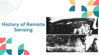
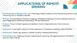
Basic Concept of Remote Sensing
By NETRA Foundation
“From the original watchtower through the anchored balloons to the reconnaissance
aircraft and remote sensing satellite, one and the same function has been indefinitely
repeated, the eye’s function being the function of the weapon”
Paul Virilio
Remote sensing is a technological that
enables the acquisition of information
about an object or phenomenon without
physical contact. It involves the use of
various sensors to gather the data, such
as electromagnetic radiation, from a
distance.
WHAT IS REMOTE
SENSING?
DEFINITION & SCOPE OF
REMOTE SENSING
Remote sensing can be defined as the science
of capturing and interpreting data about the
Earth’s surface and atmosphere using sensors.
Its scope extends to a wide range of fields,
including environmental monitoring,
agriculture, land use planning, and weather
forecasting.
History of Remote
Sensing
1858 - Gasper Felix Tournachon “Nadar” takes the first aerial photograph
from a captive balloon from an altitude of 1,200 feet over Paris
1903 - The Bavarian Pigeon Corps uses pigeons to transmit messages and
take aerial photos
1914 - WW1 provided a boost in the use of aerial photography, but after the
war, enthusiasm waned
1946 - First space photographs from V-2 rockets.
1954 - U-2 takes first flight
1959 - EXPLORER-7 launched, carried Suomi radiometer measuring solar &
terrestrial radiation (ERB Study)
1960 - TIROS-1 launched, Carried just an ordinary TV camera. It was the
beginning of Satellite Meteorology
Electromagnetic Radiation
Remote sensing relies on the principle
that all objects emit or reflect
electromagnetic radiation.
PRINCIPLES OF
REMOTE
SENSING Sensor System
Sensors play a vital role in remote
sensing by capturing and recording
electromagnetic radiation.
DATA ACQUISITION IN REMOTE
SENSING
The acquired data undergoes processing and analysis to extract meaningful insights, such as identifying
land use patterns or monitoring natural disasters. The accuracy and reliability of the acquired data are
vital for informed decision-making in sectors like agriculture, urban planning, and disaster management.
Efficient data acquisition ensures the availability of up-to-date and pertinent information for diverse
application.
Satellite: Satellite gather data by capturing
images of the Earth’s surface.
Aerial Platform: Drones or Aircrafts provide high
resolution imagery for detailed analysis.
Ground-based Platform: Ground-based
sensors are employed for specific applications,
such as weather monitoring and environmental
studies.
STAGES OF REMOTE
SENSING
Source of energy or Illumination
Radiation and the Atmosphere
Interaction with the Target
Recording of the Energy by the Sensors
Transmission, Reception and Processing
Interpretation and Analysis
Application
Lorna Alvarado
Satellite Remote
Sensing
vs.
Aerial Photography
Aerial Photography
Speed: very high, high temporal
resolution
Level of details: 50 cm in Geo
Eye-1
Weather condition: cloud is big
hinderance in optical data
Type of data: less, as each new
data type needs new satellite
launching
Location: cross boarder images
and large swath images can be
easily taken
Post processing: easy because
of single image covering large
area
Speed: slow, needs more time to
cover an area, not regular
Level of details: may go upto 2.5
cm
Weather condition: may work in
high and thin cloud
Type of data: high, as new data
type needs new sensors to be
mounted in aircraft
Location: cross boarder images
cannot be taken without
permission
Post processing: tough due to
large number of images covering
a small area
Satellite Remote Sensing
TYPES OF REMOTE SENSING
Active Remote Sensing: Sensors emit
energy in order to scan the object and
area, then the sensor detects and
measures the radiation reflected by the
object.
LIDAR(CALIPSO, LITE), RADAR(SAR, PR, CPR),
SONAR
Passive Remote Sensing: Sensors detect
natural radiation emitted or reflected by
the object or surrounding area.
ASTER, LANSDSAT, AVHRR, MODIS
APPLICATIONS OF REMOTE
SENSING
Natural Resource Management: LULC, Hydrology, Habitat analysis, Environmental assessment, Lake
monitoring, Pest or disease outbreak.
Geology: Surficial deposit / bedrock mapping, Lithological mapping, Structural mapping, Sand and
gravel (aggregate) exploration/exploitation, Mineral exploration.
Forestry: Forest mineral mapping and updation, Forest change detection, Forest resource
inventory.
Agriculture: Crop health analysis, Precision agriculture, Compliance mapping, Yield estimation.
Urbanization: Road map updation, Asphalt condition, Wetland Delineation.
National Security: Targeting, Disaster mapping and monitoring, Damage assessment, Homeland
security, Policy making.
THANK YOU

Basic Understanding of Remote Sensing.pdf

  • 1.
    Basic Concept ofRemote Sensing By NETRA Foundation
  • 2.
    “From the originalwatchtower through the anchored balloons to the reconnaissance aircraft and remote sensing satellite, one and the same function has been indefinitely repeated, the eye’s function being the function of the weapon” Paul Virilio
  • 3.
    Remote sensing isa technological that enables the acquisition of information about an object or phenomenon without physical contact. It involves the use of various sensors to gather the data, such as electromagnetic radiation, from a distance. WHAT IS REMOTE SENSING?
  • 4.
    DEFINITION & SCOPEOF REMOTE SENSING Remote sensing can be defined as the science of capturing and interpreting data about the Earth’s surface and atmosphere using sensors. Its scope extends to a wide range of fields, including environmental monitoring, agriculture, land use planning, and weather forecasting.
  • 5.
  • 6.
    1858 - GasperFelix Tournachon “Nadar” takes the first aerial photograph from a captive balloon from an altitude of 1,200 feet over Paris 1903 - The Bavarian Pigeon Corps uses pigeons to transmit messages and take aerial photos 1914 - WW1 provided a boost in the use of aerial photography, but after the war, enthusiasm waned 1946 - First space photographs from V-2 rockets. 1954 - U-2 takes first flight 1959 - EXPLORER-7 launched, carried Suomi radiometer measuring solar & terrestrial radiation (ERB Study) 1960 - TIROS-1 launched, Carried just an ordinary TV camera. It was the beginning of Satellite Meteorology
  • 7.
    Electromagnetic Radiation Remote sensingrelies on the principle that all objects emit or reflect electromagnetic radiation. PRINCIPLES OF REMOTE SENSING Sensor System Sensors play a vital role in remote sensing by capturing and recording electromagnetic radiation.
  • 8.
    DATA ACQUISITION INREMOTE SENSING The acquired data undergoes processing and analysis to extract meaningful insights, such as identifying land use patterns or monitoring natural disasters. The accuracy and reliability of the acquired data are vital for informed decision-making in sectors like agriculture, urban planning, and disaster management. Efficient data acquisition ensures the availability of up-to-date and pertinent information for diverse application. Satellite: Satellite gather data by capturing images of the Earth’s surface. Aerial Platform: Drones or Aircrafts provide high resolution imagery for detailed analysis. Ground-based Platform: Ground-based sensors are employed for specific applications, such as weather monitoring and environmental studies.
  • 9.
    STAGES OF REMOTE SENSING Sourceof energy or Illumination Radiation and the Atmosphere Interaction with the Target Recording of the Energy by the Sensors Transmission, Reception and Processing Interpretation and Analysis Application
  • 10.
  • 11.
    Aerial Photography Speed: veryhigh, high temporal resolution Level of details: 50 cm in Geo Eye-1 Weather condition: cloud is big hinderance in optical data Type of data: less, as each new data type needs new satellite launching Location: cross boarder images and large swath images can be easily taken Post processing: easy because of single image covering large area Speed: slow, needs more time to cover an area, not regular Level of details: may go upto 2.5 cm Weather condition: may work in high and thin cloud Type of data: high, as new data type needs new sensors to be mounted in aircraft Location: cross boarder images cannot be taken without permission Post processing: tough due to large number of images covering a small area Satellite Remote Sensing
  • 12.
    TYPES OF REMOTESENSING Active Remote Sensing: Sensors emit energy in order to scan the object and area, then the sensor detects and measures the radiation reflected by the object. LIDAR(CALIPSO, LITE), RADAR(SAR, PR, CPR), SONAR Passive Remote Sensing: Sensors detect natural radiation emitted or reflected by the object or surrounding area. ASTER, LANSDSAT, AVHRR, MODIS
  • 13.
    APPLICATIONS OF REMOTE SENSING NaturalResource Management: LULC, Hydrology, Habitat analysis, Environmental assessment, Lake monitoring, Pest or disease outbreak. Geology: Surficial deposit / bedrock mapping, Lithological mapping, Structural mapping, Sand and gravel (aggregate) exploration/exploitation, Mineral exploration. Forestry: Forest mineral mapping and updation, Forest change detection, Forest resource inventory. Agriculture: Crop health analysis, Precision agriculture, Compliance mapping, Yield estimation. Urbanization: Road map updation, Asphalt condition, Wetland Delineation. National Security: Targeting, Disaster mapping and monitoring, Damage assessment, Homeland security, Policy making.
  • 14.