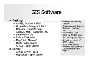
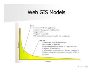
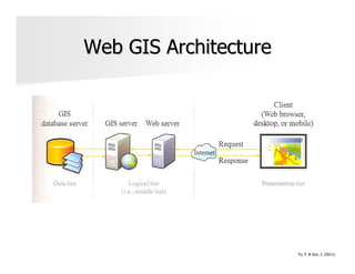
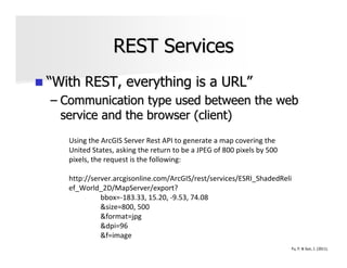
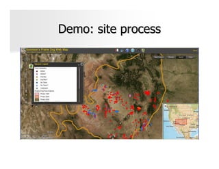
SlideShare a Scribd company logo
Web Mapping & The
 Power of Where


           Lisa Arnold
           lisaarn@gmail.com
           Twitter @lisaarn
About Me
GIS Analyst – Natural Heritage New Mexico,
Museum of Southwestern Biology, University of
New Mexico
Adjunct Instructor – Department of Geography,
University of New Mexico

 Geographic information   Spatial modeling
 science                  Web mapping
 Conservation GIS         GPS
Have a little bite


             http://ndnforum.com/blogs//index.php/2009/07/03/freedom-pass-it-on?blog=6
Geographic Information System
GIS is a computer-
based technology to
collect, integrate,
analyze, query, model
and visualize
geographic-oriented
data (like a visual
database)


  Technology, Methodology, Profession, Business
                                                  Bolstad, P. (2008).
Answer Global and Local Questions
 Location
  –   What is at …?
  –   What exists at a particular location?
 Condition
  –   Where is it?
  –   Find location where certain conditions
      are satisfied.
 Trends
  –   What has changed since?
  –   Differences in an area over time.
 Patterns
  –   What spatial patterns exist?
  –   Spatial relationships between
      geographic data.
 Modeling
  –   What if …?
  –   Predict cause and effects of new
      scenarios.


                        Great examples of GIS in action here!
GIS Software
Desktop                           Professional Industry
–   ArcGIS, ArcView – ESRI         Leader
–   Geomedia – Intergraph Corp.   •Environmental Systems
–   MapInfo – MapInfo Corp.        Research Institute,
                                   Inc.
–   AutoCAD Map – AutoDesk Inc.   •Founded in 1969
–   Smallworld - GE               •Used by 24,000 state
–   Idrisi – Clark Labs            and local governments
–   MapPoint - Microsoft          •Annual revenues of
–   QGIS – open source             $794 million
                                  •20% of revenues
–   GRASS – open source            invested in Research &
Server                             Development each
                                   year
– ArcGIS Server - ESRI
– MapServer – open source
Geospatial Revolution
http://geospatialrevolution.psu.edu/episod
e2/chapter3


      Don’t miss these videos!
Web GIS Models


                 Fu, P. & Sun, J. (2011).
Web GIS Architecture


                       Fu, P. & Sun, J. (2011).
Application Components
Basemap
– Often cached services pre-created by server
      Road map
      Aerial imagery
Operational layers
– Dynamic data rendered by the browser
      Real time weather
      Disease locations
Tools
–   Find an address
–   Get directions
–   Query or search
Geospatial Web Services
Application components are driven by
geospatial web services
– Web service is a method of communication
– Programming interface that can be accessed
  by other applications
Fu, P. & Sun, J. (2011).
Service Functions
Map services
– Most basic: display, query, identify
Data services
– Edit, serve imagery, synchronize
Analytical services
– Geocode, route, proximity, buffer,
– Geoprocessing – custom analysis models
Service Standards
Open Geospatial Consortium
– WMS (Web Map Service)
– WFS (Web Feature Service)
– WCS (Web Coverage Service )
Other related standards
– KML (Keyhole Markup Language)
– GEORSS
– GML (Geography Markup Language)
REST Services
“With REST, everything is a URL”
– Communication type used between the web
  service and the browser (client)
   Using the ArcGIS Server Rest API to generate a map covering the
   United States, asking the return to be a JPEG of 800 pixels by 500
   pixels, the request is the following:

   http://server.arcgisonline.com/ArcGIS/rest/services/ESRI_ShadedReli
   ef_World_2D/MapServer/export?
             bbox=-183.33, 15.20, -9.53, 74.08
             &size=800, 500
             &format=jpg
             &dpi=96
             &f=image
                                                                        Fu, P. & Sun, J. (2011).
The Mashup
Bringing it all together
– Integrate diverse resources to create an
  application
Use browser side API to represent web
services and handle user interaction
– API for JavaScript
– API for Flex
– API for Silverlight
ArcGIS Viewer for Flex
Demo: site process
Start right now!
ArcGIS.com
– Search for geospatial web services
– Create and share a mashup without
  programming
ESRI’s Mapping for Everyone Site
– Create and share maps
– http://www.esri.com/mapping-for-
  everyone/index.html
Book Recommendations


Fu, P. & Sun, J. (2011). Web   Duvander, A. (2010). Map
GIS: Principles and            Scripting 101. San Francisco,
Applications. Redlands, CA:    CA: No Starch Press, Inc.
ESRI Press.
References
Bolstad, P. (2008). GIS Fundamentals: A first text on
geographic information systems. White Bear Lake, MN:
Eider Press.
Fu, P. & Sun, J. (2011). Web GIS: Principles and
Applications. Redlands, CA: ESRI Press.
http://www.gis.com/
http://www.esri.com/
http://www.arcgis.com/home/
http://help.arcgis.com/en/webapps/flexviewer/
http://help.arcgis.com/en/webapi/flex/index.html
http://www.esri.com/news/publications/index.html
http://www.esri.com/mapping-for-everyone/index.html
http://geospatialrevolution.psu.edu/
Thanks!
Tell me what you think
– http://spkr8.com/t/5549
– http://speakerrate.com/series/181-
  webuquerque-2011


                            Lisa Arnold
                            lisaarn@gmail.com
                            Twitter @lisaarn

More Related Content

What's hot

Google map
Google mapGoogle map
Google map
SANDHYA ANILKUMAR
 
Maximizing Benefits from Municipal GIS Operations The GIS Management Institu...
Maximizing Benefits from Municipal GIS Operations  The GIS Management Institu...Maximizing Benefits from Municipal GIS Operations  The GIS Management Institu...
Maximizing Benefits from Municipal GIS Operations The GIS Management Institu...
Greg Babinski
 
Web tools for redd monitoring and planning
Web tools for redd monitoring and planning  Web tools for redd monitoring and planning
Web tools for redd monitoring and planning
Decision and Policy Analysis Program
 
What is GIS
What is GISWhat is GIS
What is GIS
Esri
 
GIS for Urban Planning and Design
GIS for Urban Planning and DesignGIS for Urban Planning and Design
GIS for Urban Planning and Design
Anthony Smith
 
MODERN trends of GIS
MODERN trends of GISMODERN trends of GIS
MODERN trends of GIS
VAISHALI JAIN
 
Geograpic Information Systems
Geograpic Information SystemsGeograpic Information Systems
Geograpic Information Systems
Christina Sookdeo
 
Gis application in civil engineering
Gis application in civil engineeringGis application in civil engineering
Gis application in civil engineering
Amal C Varghese
 
civil engineer
civil engineercivil engineer
civil engineer
AHMED NADIM JILANI
 
GIS Use in Map, Chart, and Data Production
GIS Use in Map, Chart, and Data ProductionGIS Use in Map, Chart, and Data Production
GIS Use in Map, Chart, and Data Production
Esri
 
Gis in transportation
Gis in transportationGis in transportation
Gis in transportation
Ashan Senarathne
 
Smart city and gis
Smart city and gisSmart city and gis
Smart city and gis
Ravi Shrestha
 
GIS and GPS - applications in civil engg
GIS and GPS - applications  in civil enggGIS and GPS - applications  in civil engg
GIS and GPS - applications in civil enggPundlik Rathod
 
Gis training ppt
Gis training pptGis training ppt
Gis training ppt
globalp7
 
Stuart Miller - GIS Output and the Role of Cartography
Stuart Miller - GIS Output and the Role of CartographyStuart Miller - GIS Output and the Role of Cartography
Stuart Miller - GIS Output and the Role of Cartography
British Cartographic Society
 
Geospatial Applications in Civil Engineering
Geospatial Applications in Civil EngineeringGeospatial Applications in Civil Engineering
Geospatial Applications in Civil Engineering
Sriharsha Rangineni
 
Gis applications in tourism a tool for sustainable tourism
Gis applications in tourism  a tool for sustainable tourismGis applications in tourism  a tool for sustainable tourism
Gis applications in tourism a tool for sustainable tourism
pankaj kumar
 
Future of GIS, Moving to the Enterprise Platform
Future of GIS, Moving to the Enterprise PlatformFuture of GIS, Moving to the Enterprise Platform
Future of GIS, Moving to the Enterprise Platform
SSP Innovations
 
Gis in urban
Gis in urbanGis in urban
Gis in urban
Dilhan Bandara
 
Gis technology Application in Urban Planning in Kenya - Mathenge Mwehe
Gis technology Application in Urban Planning in Kenya - Mathenge MweheGis technology Application in Urban Planning in Kenya - Mathenge Mwehe
Gis technology Application in Urban Planning in Kenya - Mathenge Mwehe
Mathenge Mwehe
 

What's hot (20)

Google map
Google mapGoogle map
Google map
 
Maximizing Benefits from Municipal GIS Operations The GIS Management Institu...
Maximizing Benefits from Municipal GIS Operations  The GIS Management Institu...Maximizing Benefits from Municipal GIS Operations  The GIS Management Institu...
Maximizing Benefits from Municipal GIS Operations The GIS Management Institu...
 
Web tools for redd monitoring and planning
Web tools for redd monitoring and planning  Web tools for redd monitoring and planning
Web tools for redd monitoring and planning
 
What is GIS
What is GISWhat is GIS
What is GIS
 
GIS for Urban Planning and Design
GIS for Urban Planning and DesignGIS for Urban Planning and Design
GIS for Urban Planning and Design
 
MODERN trends of GIS
MODERN trends of GISMODERN trends of GIS
MODERN trends of GIS
 
Geograpic Information Systems
Geograpic Information SystemsGeograpic Information Systems
Geograpic Information Systems
 
Gis application in civil engineering
Gis application in civil engineeringGis application in civil engineering
Gis application in civil engineering
 
civil engineer
civil engineercivil engineer
civil engineer
 
GIS Use in Map, Chart, and Data Production
GIS Use in Map, Chart, and Data ProductionGIS Use in Map, Chart, and Data Production
GIS Use in Map, Chart, and Data Production
 
Gis in transportation
Gis in transportationGis in transportation
Gis in transportation
 
Smart city and gis
Smart city and gisSmart city and gis
Smart city and gis
 
GIS and GPS - applications in civil engg
GIS and GPS - applications  in civil enggGIS and GPS - applications  in civil engg
GIS and GPS - applications in civil engg
 
Gis training ppt
Gis training pptGis training ppt
Gis training ppt
 
Stuart Miller - GIS Output and the Role of Cartography
Stuart Miller - GIS Output and the Role of CartographyStuart Miller - GIS Output and the Role of Cartography
Stuart Miller - GIS Output and the Role of Cartography
 
Geospatial Applications in Civil Engineering
Geospatial Applications in Civil EngineeringGeospatial Applications in Civil Engineering
Geospatial Applications in Civil Engineering
 
Gis applications in tourism a tool for sustainable tourism
Gis applications in tourism  a tool for sustainable tourismGis applications in tourism  a tool for sustainable tourism
Gis applications in tourism a tool for sustainable tourism
 
Future of GIS, Moving to the Enterprise Platform
Future of GIS, Moving to the Enterprise PlatformFuture of GIS, Moving to the Enterprise Platform
Future of GIS, Moving to the Enterprise Platform
 
Gis in urban
Gis in urbanGis in urban
Gis in urban
 
Gis technology Application in Urban Planning in Kenya - Mathenge Mwehe
Gis technology Application in Urban Planning in Kenya - Mathenge MweheGis technology Application in Urban Planning in Kenya - Mathenge Mwehe
Gis technology Application in Urban Planning in Kenya - Mathenge Mwehe
 

Viewers also liked

Ria与Geo Web连横共进
Ria与Geo Web连横共进Ria与Geo Web连横共进
Ria与Geo Web连横共进George Ang
 
Aag 09 F1 Good Good
Aag 09 F1 Good GoodAag 09 F1 Good Good
Aag 09 F1 Good Good
seagor
 
Esri Uc Fgdc
Esri Uc FgdcEsri Uc Fgdc
Esri Uc Fgdcseagor
 
Context is King - by Felix Petersen
Context is King - by Felix PetersenContext is King - by Felix Petersen
Context is King - by Felix Petersen
guest14533f
 
A present history of critical GIS
A present history of critical GISA present history of critical GIS
A present history of critical GIS
Matthew Wilson
 
Iste 2011 googlespatial kolvoord
Iste 2011 googlespatial kolvoordIste 2011 googlespatial kolvoord
Iste 2011 googlespatial kolvoord
papersh21
 

Viewers also liked (7)

Cs7 p20 johnson using the geoweb
Cs7 p20 johnson using the geowebCs7 p20 johnson using the geoweb
Cs7 p20 johnson using the geoweb
 
Ria与Geo Web连横共进
Ria与Geo Web连横共进Ria与Geo Web连横共进
Ria与Geo Web连横共进
 
Aag 09 F1 Good Good
Aag 09 F1 Good GoodAag 09 F1 Good Good
Aag 09 F1 Good Good
 
Esri Uc Fgdc
Esri Uc FgdcEsri Uc Fgdc
Esri Uc Fgdc
 
Context is King - by Felix Petersen
Context is King - by Felix PetersenContext is King - by Felix Petersen
Context is King - by Felix Petersen
 
A present history of critical GIS
A present history of critical GISA present history of critical GIS
A present history of critical GIS
 
Iste 2011 googlespatial kolvoord
Iste 2011 googlespatial kolvoordIste 2011 googlespatial kolvoord
Iste 2011 googlespatial kolvoord
 

Similar to Arnold webuquerque20110302

IGIS Workshop - Introduction to ArcGIS Pro - Apr 2022 - Presentation.pdf
IGIS Workshop - Introduction to ArcGIS Pro - Apr 2022 - Presentation.pdfIGIS Workshop - Introduction to ArcGIS Pro - Apr 2022 - Presentation.pdf
IGIS Workshop - Introduction to ArcGIS Pro - Apr 2022 - Presentation.pdf
noureddinebassa1
 
Geocart workshop
Geocart workshopGeocart workshop
Geocart workshop
Aileen Buckley
 
Gisruk2013 addy edit2
Gisruk2013 addy edit2Gisruk2013 addy edit2
Gisruk2013 addy edit2Addy Pope
 
The User-participated Geospatial Web as Open Platform
The User-participated Geospatial Web as Open PlatformThe User-participated Geospatial Web as Open Platform
The User-participated Geospatial Web as Open Platform
Channy Yun
 
GIS 2.0 and Neogeography
GIS 2.0 and NeogeographyGIS 2.0 and Neogeography
GIS 2.0 and Neogeography
Joshua Campbell
 
Live on everest
Live on everestLive on everest
Live on everest
Allan Laframboise
 
Working with arcgis online
Working with arcgis onlineWorking with arcgis online
Working with arcgis onlinezmmin383
 
Esri user conference highlights v0.2 15072020_hah
Esri user conference highlights v0.2 15072020_hahEsri user conference highlights v0.2 15072020_hah
Esri user conference highlights v0.2 15072020_hah
Haitham A.Hamdan
 
Geo services, social media and gis applications - Live on Everest
Geo services, social media and gis applications - Live on EverestGeo services, social media and gis applications - Live on Everest
Geo services, social media and gis applications - Live on EverestAllan Laframboise
 
Intro GIS.pptx
Intro GIS.pptxIntro GIS.pptx
Intro GIS.pptx
SamiDan2
 
Overview of MassGIS Web Mapping Services
Overview of MassGIS Web Mapping ServicesOverview of MassGIS Web Mapping Services
Overview of MassGIS Web Mapping Services
aleda_freeman
 
ArcGIS and Multi-D: Tools & Roadmap
ArcGIS and Multi-D: Tools & RoadmapArcGIS and Multi-D: Tools & Roadmap
ArcGIS and Multi-D: Tools & Roadmap
The HDF-EOS Tools and Information Center
 
An Overview of Web GIS and Location Based Services
An Overview of Web GIS and Location Based ServicesAn Overview of Web GIS and Location Based Services
An Overview of Web GIS and Location Based Services
webmapsolutions
 
My ppt on gis
My ppt on gisMy ppt on gis
My ppt on gis
gargsonakshi1
 
How to empower community by using GIS lecture 1
How to empower community by using GIS lecture 1How to empower community by using GIS lecture 1
How to empower community by using GIS lecture 1wang yaohui
 
UCT GIS Labs
UCT GIS LabsUCT GIS Labs
UCT GIS Labs
pvhead123
 
gis.pdf
gis.pdfgis.pdf
gis.pdf
RaduPopa30
 
gis.pdf
gis.pdfgis.pdf
gis.pdf
RaduPopa30
 
GIS Presentation.pptx
GIS Presentation.pptxGIS Presentation.pptx
GIS Presentation.pptx
AbdilbasitHamid
 
My GIS Timeline
My GIS TimelineMy GIS Timeline
My GIS Timeline
jeffhobbs
 

Similar to Arnold webuquerque20110302 (20)

IGIS Workshop - Introduction to ArcGIS Pro - Apr 2022 - Presentation.pdf
IGIS Workshop - Introduction to ArcGIS Pro - Apr 2022 - Presentation.pdfIGIS Workshop - Introduction to ArcGIS Pro - Apr 2022 - Presentation.pdf
IGIS Workshop - Introduction to ArcGIS Pro - Apr 2022 - Presentation.pdf
 
Geocart workshop
Geocart workshopGeocart workshop
Geocart workshop
 
Gisruk2013 addy edit2
Gisruk2013 addy edit2Gisruk2013 addy edit2
Gisruk2013 addy edit2
 
The User-participated Geospatial Web as Open Platform
The User-participated Geospatial Web as Open PlatformThe User-participated Geospatial Web as Open Platform
The User-participated Geospatial Web as Open Platform
 
GIS 2.0 and Neogeography
GIS 2.0 and NeogeographyGIS 2.0 and Neogeography
GIS 2.0 and Neogeography
 
Live on everest
Live on everestLive on everest
Live on everest
 
Working with arcgis online
Working with arcgis onlineWorking with arcgis online
Working with arcgis online
 
Esri user conference highlights v0.2 15072020_hah
Esri user conference highlights v0.2 15072020_hahEsri user conference highlights v0.2 15072020_hah
Esri user conference highlights v0.2 15072020_hah
 
Geo services, social media and gis applications - Live on Everest
Geo services, social media and gis applications - Live on EverestGeo services, social media and gis applications - Live on Everest
Geo services, social media and gis applications - Live on Everest
 
Intro GIS.pptx
Intro GIS.pptxIntro GIS.pptx
Intro GIS.pptx
 
Overview of MassGIS Web Mapping Services
Overview of MassGIS Web Mapping ServicesOverview of MassGIS Web Mapping Services
Overview of MassGIS Web Mapping Services
 
ArcGIS and Multi-D: Tools & Roadmap
ArcGIS and Multi-D: Tools & RoadmapArcGIS and Multi-D: Tools & Roadmap
ArcGIS and Multi-D: Tools & Roadmap
 
An Overview of Web GIS and Location Based Services
An Overview of Web GIS and Location Based ServicesAn Overview of Web GIS and Location Based Services
An Overview of Web GIS and Location Based Services
 
My ppt on gis
My ppt on gisMy ppt on gis
My ppt on gis
 
How to empower community by using GIS lecture 1
How to empower community by using GIS lecture 1How to empower community by using GIS lecture 1
How to empower community by using GIS lecture 1
 
UCT GIS Labs
UCT GIS LabsUCT GIS Labs
UCT GIS Labs
 
gis.pdf
gis.pdfgis.pdf
gis.pdf
 
gis.pdf
gis.pdfgis.pdf
gis.pdf
 
GIS Presentation.pptx
GIS Presentation.pptxGIS Presentation.pptx
GIS Presentation.pptx
 
My GIS Timeline
My GIS TimelineMy GIS Timeline
My GIS Timeline
 

Recently uploaded

When stars align: studies in data quality, knowledge graphs, and machine lear...
When stars align: studies in data quality, knowledge graphs, and machine lear...When stars align: studies in data quality, knowledge graphs, and machine lear...
When stars align: studies in data quality, knowledge graphs, and machine lear...
Elena Simperl
 
LF Energy Webinar: Electrical Grid Modelling and Simulation Through PowSyBl -...
LF Energy Webinar: Electrical Grid Modelling and Simulation Through PowSyBl -...LF Energy Webinar: Electrical Grid Modelling and Simulation Through PowSyBl -...
LF Energy Webinar: Electrical Grid Modelling and Simulation Through PowSyBl -...
DanBrown980551
 
Encryption in Microsoft 365 - ExpertsLive Netherlands 2024
Encryption in Microsoft 365 - ExpertsLive Netherlands 2024Encryption in Microsoft 365 - ExpertsLive Netherlands 2024
Encryption in Microsoft 365 - ExpertsLive Netherlands 2024
Albert Hoitingh
 
Le nuove frontiere dell'AI nell'RPA con UiPath Autopilot™
Le nuove frontiere dell'AI nell'RPA con UiPath Autopilot™Le nuove frontiere dell'AI nell'RPA con UiPath Autopilot™
Le nuove frontiere dell'AI nell'RPA con UiPath Autopilot™
UiPathCommunity
 
The Art of the Pitch: WordPress Relationships and Sales
The Art of the Pitch: WordPress Relationships and SalesThe Art of the Pitch: WordPress Relationships and Sales
The Art of the Pitch: WordPress Relationships and Sales
Laura Byrne
 
Secstrike : Reverse Engineering & Pwnable tools for CTF.pptx
Secstrike : Reverse Engineering & Pwnable tools for CTF.pptxSecstrike : Reverse Engineering & Pwnable tools for CTF.pptx
Secstrike : Reverse Engineering & Pwnable tools for CTF.pptx
nkrafacyberclub
 
Dev Dives: Train smarter, not harder – active learning and UiPath LLMs for do...
Dev Dives: Train smarter, not harder – active learning and UiPath LLMs for do...Dev Dives: Train smarter, not harder – active learning and UiPath LLMs for do...
Dev Dives: Train smarter, not harder – active learning and UiPath LLMs for do...
UiPathCommunity
 
How world-class product teams are winning in the AI era by CEO and Founder, P...
How world-class product teams are winning in the AI era by CEO and Founder, P...How world-class product teams are winning in the AI era by CEO and Founder, P...
How world-class product teams are winning in the AI era by CEO and Founder, P...
Product School
 
GenAISummit 2024 May 28 Sri Ambati Keynote: AGI Belongs to The Community in O...
GenAISummit 2024 May 28 Sri Ambati Keynote: AGI Belongs to The Community in O...GenAISummit 2024 May 28 Sri Ambati Keynote: AGI Belongs to The Community in O...
GenAISummit 2024 May 28 Sri Ambati Keynote: AGI Belongs to The Community in O...
Sri Ambati
 
Elizabeth Buie - Older adults: Are we really designing for our future selves?
Elizabeth Buie - Older adults: Are we really designing for our future selves?Elizabeth Buie - Older adults: Are we really designing for our future selves?
Elizabeth Buie - Older adults: Are we really designing for our future selves?
Nexer Digital
 
GDG Cloud Southlake #33: Boule & Rebala: Effective AppSec in SDLC using Deplo...
GDG Cloud Southlake #33: Boule & Rebala: Effective AppSec in SDLC using Deplo...GDG Cloud Southlake #33: Boule & Rebala: Effective AppSec in SDLC using Deplo...
GDG Cloud Southlake #33: Boule & Rebala: Effective AppSec in SDLC using Deplo...
James Anderson
 
The Future of Platform Engineering
The Future of Platform EngineeringThe Future of Platform Engineering
The Future of Platform Engineering
Jemma Hussein Allen
 
Welocme to ViralQR, your best QR code generator.
Welocme to ViralQR, your best QR code generator.Welocme to ViralQR, your best QR code generator.
Welocme to ViralQR, your best QR code generator.
ViralQR
 
A tale of scale & speed: How the US Navy is enabling software delivery from l...
A tale of scale & speed: How the US Navy is enabling software delivery from l...A tale of scale & speed: How the US Navy is enabling software delivery from l...
A tale of scale & speed: How the US Navy is enabling software delivery from l...
sonjaschweigert1
 
Elevating Tactical DDD Patterns Through Object Calisthenics
Elevating Tactical DDD Patterns Through Object CalisthenicsElevating Tactical DDD Patterns Through Object Calisthenics
Elevating Tactical DDD Patterns Through Object Calisthenics
Dorra BARTAGUIZ
 
State of ICS and IoT Cyber Threat Landscape Report 2024 preview
State of ICS and IoT Cyber Threat Landscape Report 2024 previewState of ICS and IoT Cyber Threat Landscape Report 2024 preview
State of ICS and IoT Cyber Threat Landscape Report 2024 preview
Prayukth K V
 
FIDO Alliance Osaka Seminar: Passkeys at Amazon.pdf
FIDO Alliance Osaka Seminar: Passkeys at Amazon.pdfFIDO Alliance Osaka Seminar: Passkeys at Amazon.pdf
FIDO Alliance Osaka Seminar: Passkeys at Amazon.pdf
FIDO Alliance
 
Bits & Pixels using AI for Good.........
Bits & Pixels using AI for Good.........Bits & Pixels using AI for Good.........
Bits & Pixels using AI for Good.........
Alison B. Lowndes
 
De-mystifying Zero to One: Design Informed Techniques for Greenfield Innovati...
De-mystifying Zero to One: Design Informed Techniques for Greenfield Innovati...De-mystifying Zero to One: Design Informed Techniques for Greenfield Innovati...
De-mystifying Zero to One: Design Informed Techniques for Greenfield Innovati...
Product School
 
Leading Change strategies and insights for effective change management pdf 1.pdf
Leading Change strategies and insights for effective change management pdf 1.pdfLeading Change strategies and insights for effective change management pdf 1.pdf
Leading Change strategies and insights for effective change management pdf 1.pdf
OnBoard
 

Recently uploaded (20)

When stars align: studies in data quality, knowledge graphs, and machine lear...
When stars align: studies in data quality, knowledge graphs, and machine lear...When stars align: studies in data quality, knowledge graphs, and machine lear...
When stars align: studies in data quality, knowledge graphs, and machine lear...
 
LF Energy Webinar: Electrical Grid Modelling and Simulation Through PowSyBl -...
LF Energy Webinar: Electrical Grid Modelling and Simulation Through PowSyBl -...LF Energy Webinar: Electrical Grid Modelling and Simulation Through PowSyBl -...
LF Energy Webinar: Electrical Grid Modelling and Simulation Through PowSyBl -...
 
Encryption in Microsoft 365 - ExpertsLive Netherlands 2024
Encryption in Microsoft 365 - ExpertsLive Netherlands 2024Encryption in Microsoft 365 - ExpertsLive Netherlands 2024
Encryption in Microsoft 365 - ExpertsLive Netherlands 2024
 
Le nuove frontiere dell'AI nell'RPA con UiPath Autopilot™
Le nuove frontiere dell'AI nell'RPA con UiPath Autopilot™Le nuove frontiere dell'AI nell'RPA con UiPath Autopilot™
Le nuove frontiere dell'AI nell'RPA con UiPath Autopilot™
 
The Art of the Pitch: WordPress Relationships and Sales
The Art of the Pitch: WordPress Relationships and SalesThe Art of the Pitch: WordPress Relationships and Sales
The Art of the Pitch: WordPress Relationships and Sales
 
Secstrike : Reverse Engineering & Pwnable tools for CTF.pptx
Secstrike : Reverse Engineering & Pwnable tools for CTF.pptxSecstrike : Reverse Engineering & Pwnable tools for CTF.pptx
Secstrike : Reverse Engineering & Pwnable tools for CTF.pptx
 
Dev Dives: Train smarter, not harder – active learning and UiPath LLMs for do...
Dev Dives: Train smarter, not harder – active learning and UiPath LLMs for do...Dev Dives: Train smarter, not harder – active learning and UiPath LLMs for do...
Dev Dives: Train smarter, not harder – active learning and UiPath LLMs for do...
 
How world-class product teams are winning in the AI era by CEO and Founder, P...
How world-class product teams are winning in the AI era by CEO and Founder, P...How world-class product teams are winning in the AI era by CEO and Founder, P...
How world-class product teams are winning in the AI era by CEO and Founder, P...
 
GenAISummit 2024 May 28 Sri Ambati Keynote: AGI Belongs to The Community in O...
GenAISummit 2024 May 28 Sri Ambati Keynote: AGI Belongs to The Community in O...GenAISummit 2024 May 28 Sri Ambati Keynote: AGI Belongs to The Community in O...
GenAISummit 2024 May 28 Sri Ambati Keynote: AGI Belongs to The Community in O...
 
Elizabeth Buie - Older adults: Are we really designing for our future selves?
Elizabeth Buie - Older adults: Are we really designing for our future selves?Elizabeth Buie - Older adults: Are we really designing for our future selves?
Elizabeth Buie - Older adults: Are we really designing for our future selves?
 
GDG Cloud Southlake #33: Boule & Rebala: Effective AppSec in SDLC using Deplo...
GDG Cloud Southlake #33: Boule & Rebala: Effective AppSec in SDLC using Deplo...GDG Cloud Southlake #33: Boule & Rebala: Effective AppSec in SDLC using Deplo...
GDG Cloud Southlake #33: Boule & Rebala: Effective AppSec in SDLC using Deplo...
 
The Future of Platform Engineering
The Future of Platform EngineeringThe Future of Platform Engineering
The Future of Platform Engineering
 
Welocme to ViralQR, your best QR code generator.
Welocme to ViralQR, your best QR code generator.Welocme to ViralQR, your best QR code generator.
Welocme to ViralQR, your best QR code generator.
 
A tale of scale & speed: How the US Navy is enabling software delivery from l...
A tale of scale & speed: How the US Navy is enabling software delivery from l...A tale of scale & speed: How the US Navy is enabling software delivery from l...
A tale of scale & speed: How the US Navy is enabling software delivery from l...
 
Elevating Tactical DDD Patterns Through Object Calisthenics
Elevating Tactical DDD Patterns Through Object CalisthenicsElevating Tactical DDD Patterns Through Object Calisthenics
Elevating Tactical DDD Patterns Through Object Calisthenics
 
State of ICS and IoT Cyber Threat Landscape Report 2024 preview
State of ICS and IoT Cyber Threat Landscape Report 2024 previewState of ICS and IoT Cyber Threat Landscape Report 2024 preview
State of ICS and IoT Cyber Threat Landscape Report 2024 preview
 
FIDO Alliance Osaka Seminar: Passkeys at Amazon.pdf
FIDO Alliance Osaka Seminar: Passkeys at Amazon.pdfFIDO Alliance Osaka Seminar: Passkeys at Amazon.pdf
FIDO Alliance Osaka Seminar: Passkeys at Amazon.pdf
 
Bits & Pixels using AI for Good.........
Bits & Pixels using AI for Good.........Bits & Pixels using AI for Good.........
Bits & Pixels using AI for Good.........
 
De-mystifying Zero to One: Design Informed Techniques for Greenfield Innovati...
De-mystifying Zero to One: Design Informed Techniques for Greenfield Innovati...De-mystifying Zero to One: Design Informed Techniques for Greenfield Innovati...
De-mystifying Zero to One: Design Informed Techniques for Greenfield Innovati...
 
Leading Change strategies and insights for effective change management pdf 1.pdf
Leading Change strategies and insights for effective change management pdf 1.pdfLeading Change strategies and insights for effective change management pdf 1.pdf
Leading Change strategies and insights for effective change management pdf 1.pdf
 

Arnold webuquerque20110302

  • 1. Web Mapping & The Power of Where Lisa Arnold lisaarn@gmail.com Twitter @lisaarn
  • 2. About Me GIS Analyst – Natural Heritage New Mexico, Museum of Southwestern Biology, University of New Mexico Adjunct Instructor – Department of Geography, University of New Mexico Geographic information Spatial modeling science Web mapping Conservation GIS GPS
  • 3. Have a little bite http://ndnforum.com/blogs//index.php/2009/07/03/freedom-pass-it-on?blog=6
  • 4. Geographic Information System GIS is a computer- based technology to collect, integrate, analyze, query, model and visualize geographic-oriented data (like a visual database) Technology, Methodology, Profession, Business Bolstad, P. (2008).
  • 5. Answer Global and Local Questions Location – What is at …? – What exists at a particular location? Condition – Where is it? – Find location where certain conditions are satisfied. Trends – What has changed since? – Differences in an area over time. Patterns – What spatial patterns exist? – Spatial relationships between geographic data. Modeling – What if …? – Predict cause and effects of new scenarios. Great examples of GIS in action here!
  • 6. GIS Software Desktop Professional Industry – ArcGIS, ArcView – ESRI Leader – Geomedia – Intergraph Corp. •Environmental Systems – MapInfo – MapInfo Corp. Research Institute, Inc. – AutoCAD Map – AutoDesk Inc. •Founded in 1969 – Smallworld - GE •Used by 24,000 state – Idrisi – Clark Labs and local governments – MapPoint - Microsoft •Annual revenues of – QGIS – open source $794 million •20% of revenues – GRASS – open source invested in Research & Server Development each year – ArcGIS Server - ESRI – MapServer – open source
  • 8. Web GIS Models Fu, P. & Sun, J. (2011).
  • 9. Web GIS Architecture Fu, P. & Sun, J. (2011).
  • 10. Application Components Basemap – Often cached services pre-created by server Road map Aerial imagery Operational layers – Dynamic data rendered by the browser Real time weather Disease locations Tools – Find an address – Get directions – Query or search
  • 11. Geospatial Web Services Application components are driven by geospatial web services – Web service is a method of communication – Programming interface that can be accessed by other applications
  • 12. Fu, P. & Sun, J. (2011).
  • 13. Service Functions Map services – Most basic: display, query, identify Data services – Edit, serve imagery, synchronize Analytical services – Geocode, route, proximity, buffer, – Geoprocessing – custom analysis models
  • 14. Service Standards Open Geospatial Consortium – WMS (Web Map Service) – WFS (Web Feature Service) – WCS (Web Coverage Service ) Other related standards – KML (Keyhole Markup Language) – GEORSS – GML (Geography Markup Language)
  • 15. REST Services “With REST, everything is a URL” – Communication type used between the web service and the browser (client) Using the ArcGIS Server Rest API to generate a map covering the United States, asking the return to be a JPEG of 800 pixels by 500 pixels, the request is the following: http://server.arcgisonline.com/ArcGIS/rest/services/ESRI_ShadedReli ef_World_2D/MapServer/export? bbox=-183.33, 15.20, -9.53, 74.08 &size=800, 500 &format=jpg &dpi=96 &f=image Fu, P. & Sun, J. (2011).
  • 16. The Mashup Bringing it all together – Integrate diverse resources to create an application Use browser side API to represent web services and handle user interaction – API for JavaScript – API for Flex – API for Silverlight
  • 18.
  • 19.
  • 21. Start right now! ArcGIS.com – Search for geospatial web services – Create and share a mashup without programming ESRI’s Mapping for Everyone Site – Create and share maps – http://www.esri.com/mapping-for- everyone/index.html
  • 22. Book Recommendations Fu, P. & Sun, J. (2011). Web Duvander, A. (2010). Map GIS: Principles and Scripting 101. San Francisco, Applications. Redlands, CA: CA: No Starch Press, Inc. ESRI Press.
  • 23. References Bolstad, P. (2008). GIS Fundamentals: A first text on geographic information systems. White Bear Lake, MN: Eider Press. Fu, P. & Sun, J. (2011). Web GIS: Principles and Applications. Redlands, CA: ESRI Press. http://www.gis.com/ http://www.esri.com/ http://www.arcgis.com/home/ http://help.arcgis.com/en/webapps/flexviewer/ http://help.arcgis.com/en/webapi/flex/index.html http://www.esri.com/news/publications/index.html http://www.esri.com/mapping-for-everyone/index.html http://geospatialrevolution.psu.edu/
  • 24. Thanks! Tell me what you think – http://spkr8.com/t/5549 – http://speakerrate.com/series/181- webuquerque-2011 Lisa Arnold lisaarn@gmail.com Twitter @lisaarn