
Recommended
Recommended
More Related Content
Similar to ANALYSIS & PROPOSALS - TRANSPORTATION.pdf
Similar to ANALYSIS & PROPOSALS - TRANSPORTATION.pdf (20)
Recently uploaded
Recently uploaded (20)
ANALYSIS & PROPOSALS - TRANSPORTATION.pdf
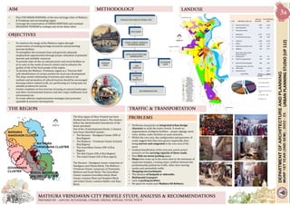
- 1. URBAN PLANNING STUDIO (UP 112) • Plan FOR URBAN RENEWAL of the twin heritage cities of Mathura & Vrindavan and surrounding region • Leverage the conservation of URBAN HERITAGE and resultant RELIGIOUS TOURISM to reshape and revive these cities FINALISE THE AREA OF WORK/ SITE SITE SURVEY VISUAL SURVEY THROUGH SECONDARY MEANS DATA COLLECTION AND ASSIMILATION PRIMARY DATA SECONDARY DATA GAP ANALYSIS PROBLEMS & PROSPECTS RECOMMENDATIONS • To reinforce the image of the Mathura region through conservation of existing heritage structures and promoting tourism facilities • To strengthen the economic base and generate adequate employment opportunities through proper utilization of potential tourism and available resources • To provide state-of-the-art infrastructure and social facilities so as to cater to the needs of tourist visitors and to enhance the quality of life of the local people of the region. • To develop the Mathura -Vrindavan region as a ‘Tourism Hub’ with identification of certain pockets for local area development • The deep rooted relationship of tourism and culture to be realised, and promotion of cultural tourism should be encouraged focusing culture related (craft, art, performing art, living style as) saleable products for tourist. • Greater emphasis on Eco‐tourism, focusing on natural landscapes and other environmental features and also virgin traditional rural environment etc. • To create effective implementation strategies that promotes equitable & inclusive development The Braj region of Uttar Pradesh has been divided into five sacred clusters. The clusters follow the administrative boundaries of the block and tehsil. Out of the 10 development blocks, 5 clusters have been identified namely – • The Barsana – Nandgaon Cluster (NW of Braj Region) • The Mathura – Vrindavan Cluster (Central Braj Region) • The Goverdhan Cluster (SW of Braj Region) • The Mat Cluster (NE of Braj Region) • The Gokul Cluster (SE of Braj region) The Barsana - Nandgaon cluster comprises of Nandgaon and Chhata Block; The Mathura – Vrindavan Cluster comprises of Chaumuha, Mathura and Farah Block; The Goverdhan Cluster contains Goverdhan block; Mant Cluster contains Mant and Naujheel Block and Gokul Cluster contains Baldev and Raya Block. S. NO. PROPOSED LAND USE AREA (IN HECTARE) % OF PROPOSED AREA I-1 Present builtup Area 1,463 14.46 2 Rural Population 416 4.11 II Proposed Landuse 1 Residential 2,775 27.44 2 Commercial & business 200 1.98 3 Industrial 1,440 14.24 4 Offices 115 1.14 5 Public & semi public area 348 3.44 6 Religious 432 4.27 7 Parks, open areas, green belt & riverfront development 263 2.6 8 Traffic & transportation 565 5.59 9 Reserved forest & garden 286 2.83 10 Flood prone area, river and water body 1,804 17.83 11 Restricted area 7 0.07 SUM TOTAL 10,114 Hectare 100% I-1 Present builtup Area 1,463 2 Rural Population 416 II Proposed Landuse 1 Residential 2,775 2 Commercial & business 200 3 Industrial 1,440 4 Offices 115 • Parikrama marg lacks an integrated urban design character to unify the entire stretch. It needs an augmentation of pilgrim facilities – proper signage, more trees, shelter, water facilities at some stretches. • Within the core area, the configuration and geometry of roads suggest that they have grown organically, thus being narrow and congested in the core area of the town. • Gradual densification of the area now exerts severe pressure on the carrying capacity of these roads. • Very little on-street parking space. • Shops have come up in the areas close to the entrances of important temples, creating major conflicts between the predominantly pedestrian traffic, other slow-moving modes and automobile traffic. • Shopping encroachments • The absence of footpath or sidewalks • Multimodal transport • Lack of parking facilities • No space for trucks near Mathura Oil Refinery
- 2. High Value zone: The core zone of heritage, religious or of tourism value is the high value zone. • Ethnic value of the zone is of the highest level and is meant for preservation. • The carrying capacity of this value zone is the key to the tourism potential of the city. • Strengthening the regional level mobility networks • Establishment of Intermediate Public Transport (IPT) facility for Last Mile Connectivity within the destinations E-rickshaw boarding points and lanes Strategic identification of boarding points as per their close proximity to the various major pilgrimage landmarks that are sprinkled across the different destinations Solar Charging stations for E-rickshaws • Redevelopment of potential corridors for optimum utilization and enhancing mobility experience Redesigning of their road sections which will include appropriate segregation of lanes for vehicles and pedestrians Induction of suitable streetscape elements such as lighting, plantation, street furniture, bollards, etc. wherever necessary Development of the corridors in accordance to their proposed road sections • Development of mobility-allied infrastructure to facilitate smoother tourist mobility / adequate parking spaces Source: URDPFI Guidelines Vol 1 Native’s Zone: This can be called as the residential zone of the locals or the settlement. • This zone usually overlaps with the high value zone, due to social interactions and economic relationships. • The economic benefits of tourism are measurable in the native zone and improvement in the quality of life of the local population can be achieved through planned development. New infrastructure zone: The city periphery or outer zone is the new development zone. • This outer zone is for the new development to come‐up to meet the tourism requirements for the promotion of tourism and for city growth. Networks: The integration of the zones is to be strong with networks. • Networks to connect zones for accessibility between the two outer zones i.e. new infrastructure zone and native’s zone shall have strong linkages, while from eco‐sensitive approach; the High Value zone shall have limited access. • For improving external connectivity up to the city/ nodes in the tourist circuit, alternative modes of transportation should be promoted. • Width of the state and national highway passing through Mathura Vrindavan needs to increase to make carrying capacity higher to cater to more traffic. • It is needed because the traffic volume is very high specially during festival time URBAN PLANNING STUDIO (UP 112) GAP IN LANDUSE- As per URDPFI guidelines, transportation & communications should be 12-14% of total landuse, while it is 5.59% here. TOWARDS RAYA TOWARDS CHHATA TOWARDS GOVARDHAN TOWARDS GOKUL
- 3. URBAN PLANNING STUDIO (UP 112) ESTABLISHMENT OF MOBILITY CORRIDOR – Core areas of both the cities, Mathura & Vrindavan needs to be connected seamlessly for uninterrupted and quick movement as they have the most important temples situated there revered by Hindus, which are Shri Krishna Janm Bhoomi in Mathura and temples around Banke Bihari temple in Vrindavan. 1. Presently, a meter gauge railway track is there connecting the two cities. • It can be developed into a MRTS corridor using the existing route. (12 kms) • Metro can also be connected with Delhi/ Noida metro for smoother regional connectivity. • A heritage train can also be proposed on the track on the lines of ‘Palace on Wheels’ • Boarding points to be made at regular intervals to ensure last mile connectivity. • E rickshaw parking facility with charging points 2. Mathura Road connects both cities and carries maximum traffic. • It varies from 30 m in outer areas to 12 m in the old areas near Deeng gate. • It needs to be broadened and integrated with the proposed MRTS/train route. VRINDAVAN MATHURA MOBILITY CORRIDOR LEGEND 1. PROPOSED BOARDING POINTS 2. PROPOSED PARKING LEGEND 1. PROPOSED NON MOTORISED ZONES 2. PROPOSED MOTORABLE ZONES
- 4. Source: URDPFI Guidelines Vol 1 URBAN PLANNING STUDIO (UP 112) VRINDAVAN STREET PATTERN MATHURA CORE AREA STREET PATTERN PEDESTRIAN FRIENDLY STREETS • To improve the streetscape along with maintaining its original character • The core area is to be made completely free of motorised traffic. • To be made fully pedestrian and for cyclists SEGREGATED CYCLE PATHS • Cycle path needs to be segregated from pedestrian path • Segregation can be done by the change in material or grade • Soft barriers can also be provided STREETSCAPING • Comfort to pedestrians is provided by dedicated facilities and amenities • Good quality Signage is provided where needed • Benches/ seats are provided at regular intervals • Proper street lighting is done • Shade is provided by trees, planned landscaping • Zebra crossing and cycle lanes are marked prominently Source: Adapted from Town Centre Master Plan, Bhubaneswar prepared for BDA by IBI Group EXISTING The core area of twin cities is dotted with numerous places of rich heritage in various forms- temples, monuments, kunds, vans, ghats, etc. which need to be showcased to the visitors for elevating their appreciation and knowledge and appreciation of the region. For this purpose, focus needs to be on core area traffic management and interventions on road
- 5. GHAT REDEVELOPMENT – • Rani Ghat and Swami Ghat to be connected by a new walkway • Re-Strengthening of Old Bridge for pedestrians, two-wheelers and E-rickshaws. • Parking near ghats • Tourist amenities to be added • Roads leading to ghats to be redesigned with focus on non motorised vehicles CROSS-SECTION GHAT REDEVELOPMENT URBAN PLANNING STUDIO (UP 112) VRINDAVAN GHATS MATHURA CORE AREA STREET PATTERN • Heritage walk is an effective tool to explore the unexplored and neglected richness of a locale. • Heritage walks to be conducted on demarcated trails that link and highlight the various forms of heritage. • These guided tours will be carried out in the depths of inner lanes of the cities, offering the visitors an opportunity to explore the unexplored and obscure richness of the Braj region. PARIKRAMA MARG REVAMP • New Bicycle Paths and walking trails with TRELLIS /PANELS • Rejuvenation of Traffic Nodes • Tourist Amenities at regular intervals • Street façade development in tune with existing architectural heritage • Proper lighting on road • Correct and theme based signages CROSS-SECTION LEGEND PROPOSED HERITAGE WALK GHATS PARIKRAMA MARG PILGRIMAGE ROUTE PILGRIMAGE ROUTE PROPOSED DESIGN INTERVENTIONS HERITAGE WALKS
- 6. PROPOSED BRT ON MATHURA ROAD WITH NMT ZONE URBAN PLANNING STUDIO (UP 112) NON MOTORISED TRANSPORT (NMT) • Non-Motorised Transport (NMT), also known as active transport, refers to modes of transport which are powered by human power rather than other forms of energy like fossil fuels. • NMT includes walking, cycling, cycle rickshaws (both passenger and goods), 4 wheel vendor carts, handcarts (for transporting goods), and even the tricycles used by persons with disabilities. • Most of the roads in Mathura and Vrindavan can be made into NMT roads by simple interventions, explained in sketches Specific vendor zone demarcated to reduce encroachment on road UNIVERSAL ACCESSIBILITY • Barrier free built environment to facilitate the specially abled and elderly • Space allowance for wheel chair • Continuous sidewalks with guiding blocks • Subways and overhead bridges to be made accessible to all PROPOSED HERITAGE TRAIN - ELEVATED Complete street design
- 7. PROPOSED WATER WAY LINK BETWEEN MATHURA AND VRINDAVAN URBAN PLANNING STUDIO (UP 112) PARKING FOR VEHICLES • Reserve short-term parking for the cars and tourist buses near the entry point • Provide long-term parking for cars and tourist buses at the inside location • Provide short term parking for cars, rickshaws, tangas near ghats, colleges, schools • Provide long-term parking for the rickshaws and tangas near Ranganathji temple and Banke Bihari temple,and Kans Kila • Very nominal, one time daily, Parking fees charged to the rickshaw, Tanga and tourist car / bus operators for short-term / long-term parking • One additional transport nagar is being proposed near the Mathura Oil Refinery as the movement of trucks is very huge there. VRINDAVAN BUS & RICKSHAW STANDS MATHURABUS & RICKSHAW STANDS LEGEND BUS STANDS (6 NOS, 10 ACRE EACH) E RICKSHAW STANDS (11 NOS. 2000 SQ. MT. EACH) CAR PARKING (6 NOS, 5000 SQ MT EACH) TRANSPORT NAGAR (1 NEW , 40 ACRE)
- 8. • To ease the congestion, many peri urban areas are planned around Mathura Vrindavan. • To ensure smooth connectivity between those areas, a six – lane ring road is proposed connecting all the newly proposed areas. • It will have interchanges at the intersections between national highways and bridge at Yamuna also. • Noida International Airport will get the country’s first personalised rapid transport system. The new pod taxi transit system will connect the airport to the Film City. As per The Uttar Pradesh Index, Yamuna Authority has shown a green signal to the project that Uttar Pradesh will cater to the country’s first-ever Pod Taxi service. • The autonomous pod taxi will run between the Jewar Airport and Film City (Sector 21). The track will be around 14 kilometres long, and it will cover places like the Handicraft Park, Apparel Park, Sector 33, Toy Park, Sector 32, MSME Park, and Sector 29. • We propose to extend the Pod taxis to Vrindavan as part of heritage city development. • They will be used exclusively on pilgrimage circuit as part of no carbon footprint transportation plan ROPEWAY PLANNED ACROSS THE YAMUNA RIVER URBAN PLANNING STUDIO (UP 112) • Braj has always been a religious pilgrimage where people come in search of peace and spirituality. • Being the birthplace of Shri Krishna and many other religious beliefs, Braj attracts millions of tourist throughout the year. • The tourist fall includes domestic as well as international tourist. • Also falling within the Golden Triangle of NewDelhi- Jaipur-Agra, the tourist visit in the region has increased. • Yamuna Expressway has also played a vital role in increasing the tourist inflow as it reduces the travel time between Delhi and Agra via Mathura. • The entire BRAJ area has good connectivity within the region as well as with other parts of the country. However, the absence of an airport in Mathura regresses the connectivity up to some extent. • To cater to such increase in footfall, many interventions are required which have been discussed here. • These interventions hope to ease the traffic congestion inside and also improve the overall experience of the tourist coming there.