The document presents a final project report for a wearable wristband called "Chain-Aid" designed to help victims communicate and evacuate in disaster situations when cellular networks are down. The wristband uses electronic paper, geolocation, peer-to-peer networking, and color-coded messages to guide users to shelters. It provides alerts, evacuation directions, SOS calls, and updates. The design was informed by research on existing disaster communication projects and new technologies like electronic paper and portable peer-to-peer networks.
Chain-Aid: Domus Master in Interaction Design Final ProjectJulie Blitzer
This presentation was the product of my Final Project (thesis) for the Domus Academy Master in Interaction Design. For more information, see http://uxblitz.com/tagged/final-project
Chain-Aid is a low-cost energy efficient wearable device that can be distributed to victims immediately following a disaster. This device will help victims to evacuate, communicate with recovery teams in the absence of cellular service and power outages.
OEM Presentation - IA and Emergency ResponseNoreen Whysel
An introduction to Information Architecture and Emergency Response technologies presented at the NYC Office of Emergency Management for the Women's History Month Breakfast. This presentation is a companion to my IA Summit presentation Information Architecture and Emergency Response, which goes into more detail on the kinds of technologies used in Emergency Response.
Lessons from Material Design on cross-channel digital experiences - DroidCon ...Julie Blitzer
This document summarizes a presentation on cross-channel digital experiences and lessons learned from Material Design. It discusses defining user actions and priorities across channels, using real-world metaphors to help users understand digital experiences, employing meaningful visual design related to user actions, and using motion and animation for user feedback. The presentation concludes by recommending that for future Android projects, designers read Material Design documentation, create a personal pattern library, define priorities and activities upfront, and support cross-channel experiences.
This document summarizes Eilidh Dickson's experience in the 150-day CIID pilot program from September 2008 to February 2009. It includes reflections on courses in computational media design, physical computing, design theory, user research, and other topics. Key lessons included challenging herself technically, appreciating different approaches to design problems, and the value of prototyping and user testing. She also expressed interest in personal informatics, elderly users, work-life balance, education, and maintaining CIID's ethos in her thesis work.
The document discusses a project exploring how personal informatics can help people achieve a more balanced life. The student, Eilidh Dickson, is investigating whether tracking intangible information about daily actions using tools like those in the emerging field of personal informatics could trigger behavior changes to help people feel more balanced. Dickson conducted initial research, mapping out existing personal informatics tools and interviewing people from different life stages to understand their values and strategies for achieving balance.
Interaction design IS NOT ABOUT computing technologyfrog
There is universal acceptance of a holistic approach to human centered design within this community – generally referred to as 'experience design' (not my preferred term). This approach considers all of the contexts surrounding use and then tries to build a unified interaction model to support user needs over time, across these contexts. It focuses not just on expressed needs but on those that are unexpressed: the emotions, motivations, and desires that shape user engagement over time.
This document discusses common UX myths and provides evidence to debunk them. It addresses myths such as people not scrolling down pages, UX being only about usability, and UX being a new concept. Specific myths debunked with evidence include that 66% of user attention is below the page fold, 90% of mobile users scroll within 14 seconds, icons do not necessarily help users find menu items compared to text, and UX practices like storyboards, personas, and user testing have been used for many years. The document encourages sharing to spread more accurate understandings of UX design concepts.
This document describes a mobile disaster management system called MyDisasterDroid that was implemented as an Android application. It uses a genetic algorithm to determine the optimal route for volunteers and rescuers to take to provide aid to the most people in the shortest time. Location data is input to the app, which then uses the traveling salesman problem and genetic algorithms to calculate the best route between locations. The app displays this route on a map and updates it dynamically as new locations are added.
QuakeUp : a Smartphone App for empowering earthquake victimsSmartsystem
This document summarizes a smartphone app called QuakeUp that aims to save lives during earthquakes by empowering victims. It was created by disaster relief experts to recognize seismic waves and enable data sharing between smartphones. The app uses existing GPS systems and satellite networks to quickly register earthquake waves and send alerts to smartphones. This provides critical seconds of warning before subsequent waves arrive and allows victims to take protective action. After the shaking stops, the app facilitates communication and coordinates rescue efforts by collecting geolocated information from users. The goal is to launch a prototype and conduct field testing with rescue organizations.
IRJET- An Innovative Method for Communication Among Differently Abled Peo...IRJET Journal
This document describes a proposed system to help improve communication between disabled individuals, including those who are deaf, blind, or mute. The system uses a glove fitted with flex sensors that can detect hand gestures. When a gesture is made, the flex sensors trigger an Arduino microcontroller to play a pre-recorded audio message or display a message on an LCD screen. The system is designed so that deaf individuals can receive messages through visual display, blind individuals can receive messages through Braille or vibration, and mute individuals can communicate through gestures. The goal is to help overcome barriers to communication between disabled people and enable them to interact with others.
This document discusses a proposed cemetery mapping and information system mobile application. The application would provide cemetery location data and link burial records, photos, and other information to maps. This would make it easier for people to locate gravesites of loved ones. The application aims to help solve problems of overcrowding and disorganization in cemeteries by providing a convenient digital alternative to physical maps. It could inform users about interment capacity and whether graves have been removed.
[Challenge:Future] Cross border health care responseChallenge:Future
This document proposes enhancing cross-border coordination of disaster response in Europe to save more lives. It suggests developing agreements between countries on sharing hospital resources and emergency response. Regular simulations testing the coordination plans could provide feedback to improve the system. The goal is that if a disaster overwhelms local capabilities, patients can quickly access care across borders, and response efforts are coordinated rather than duplicated.
Using Citizen Power in a National Disaster Alert SystemJane Uymatiao
This is my final project for the "Citizen Engagement" Coursera course offered by the World Bank (April 2015). It seeks to propose steps that would allow greater citizen participation during disasters that would complement the Philippine government's National Disaster Response Plan.
A SOS BASED APPLICATION FOR TRAVELERS TO TRAVEL ALONEvivatechijri
A traveler is a person who is traveling different places and enjoy the personal growth that occurs within the experience and people they meet. Now a days travelling in historical places and wild nature is more trending for travelers specially the solo traveler is attracted the most towards it. To interact with people, know and learn the cultures of different places, making friends solo travelling is something interesting to do, meeting People, nature, weather, etc. But at a same time, it is really dangerous to travel alone in unknown places and being a stranger all around, it is like doing something out of comfort zone which is dangerous and also expensive. There are no certain applications built for solo travelers with multiple functionalities like exploring places due to help rating security and cab sharing which can reduce their expenses. To overcome the problem’s, we are building an application name ‘Smart Travel’ application where all these functionalities will be implemented.
Slándáil | Empowering Emergency Services through Social Media
Slándáil is a European project that is investigating the use of digital media in times of natural disaster and is equipping disaster management personnel with software services for harnessing social media for better disaster response.
We are in four countries, namely: Ireland, Northern Ireland (UK), Germany, and Italy. The aim is for the project to help increase the security of citizens and groups living in areas affected by natural disasters through increasing the effectiveness and response time of disaster management teams.
http://slandail.eu/
info@slandail.eu
https://www.facebook.com/slandail
https://twitter.com/slandailfp7
Slándáil is a three-year project, funded by the European Union Seventh Framework Programme under grant agreement No. 607691 (“Slandail”)
AN INTELLIGENT SYSTEM FOR THE ENHANCEMENT OF VISUALLY IMPAIRED NAVIGATION AND...ijgca
Technological advancement has brought the masses unprecedented convenience, but unnoticed by many, a
population neglected through the age of technology has been the visually impaired population. The visually
impaired population has grown through ages with as much desire as everyone else to adventure but lack
the confidence and support to do so. Time has transported society to a new phase condensed in big data,
but to the visually impaired population, this quick-pace living lifestyle, along with the unpredictable nature
of natural disaster and COVID-19 pandemic, has dropped them deeper into a feeling of disconnection from
the society. Our application uses the global positioning system to support the visually impaired in
independent navigation, alerts them in face of natural disasters, and reminds them to sanitize their devices
during the COVID-19 pandemic
AN INTELLIGENT SYSTEM FOR THE ENHANCEMENT OF VISUALLY IMPAIRED NAVIGATION AND...ijgca
The document describes an intelligent system that uses geo-based positioning and machine learning to enhance navigation and provide disaster assistance for visually impaired users. It aims to 1) collect obstruction data during walks to predict frequencies at locations, 2) determine indoor/outdoor locations to send alerts during disasters, and 3) remind users to sanitize their device after a certain frequency. The system provides navigation assistance, disaster alerts, and COVID-19 reminders to promote independence for visually impaired users. It experiments with support vector machines and regression models to determine the best machine learning approach.
This document proposes using wearable devices and Bluetooth beacons to track the location of dementia patients within senior living facilities. By creating a handshake between the wearable devices and strategically placed beacons, caregivers could monitor patients' real-time locations and receive alerts if a patient leaves a restricted area or removes their device. This system could reduce costly search operations when patients wander by 55-65%, saving an estimated $48 million for the company over three years. In addition to financial benefits, the system would provide peace of mind to caregivers and patients' families by allowing constant monitoring and faster emergency response.
1. The document discusses a study that mapped the information needs of decision makers during flood response in Bangladesh to available data sets, in order to identify information gaps. Interviews and focus groups identified timely and location-based information as the most important need not well covered.
2. The study recommends identifying information requirements and available data sources during preparedness to help address gaps in initial response. Future research aims to close gaps by linking disparate data sets and collecting community-level data with mobile apps.
3. The study was conducted in partnership with organizations implementing early warning systems on riverine islands in Bangladesh, to better support communities before, during and after floods.
Crying Wolf in the Global Village: Managing Disaster Early Warnings in the Ag...Nalaka Gunawardene
The challenge in disaster early warnings is to make the best possible decisions quickly using imperfect information. With lives and livelihoods at stake, there is much pressure to get it right. But one can’t be timely and perfectly accurate at the same time.
We have come a long way since the devastating Boxing Day tsunami of December 2004 caught Indian Ocean countries by surprise. Many of the over 230,000 people killed that day could have been saved by timely coastal evacuations.
The good news is that advances in science and communications technology, greater international cooperation, and revamped national systems have vastly improved tsunami early warnings during the past decade. However, some critical gaps and challenges remain.
The Indian Ocean Tsunami Warning and Mitigation System (IOTWS) was set up in 2005 under UNESCO’s Intergovernmental Oceanographic Commission. Over USD 400 million has been invested in state of the art equipment for rapid detection and assessment. However, the system’s overall effectiveness is limited by poor local infrastructure and lack of preparedness. Some countries also lack efficient decision-making for issuing national level warnings based on regionally provided rapid assessments.
Warnings must reach communities at risk early enough for action. False warnings can cause major economic losses and reduce compliance with future evacuation orders. Only governments can balance these factors. It is important that there be clearer protocols within governments to consider the best available information and make the necessary decisions quickly.
Now, the proliferation of information and communication technologies (ICTs) is making this delicate balance even more difficult. To remain effective in the always-connected and chattering Global Village, disaster managers have to rethink their engagement strategies.
Controlled release of information is no longer an option for governments. In the age of 24/7 news channels and social media, many people will learn of breaking disasters independently of official sources. Some social media users will also express their views instantly – and not always accurately.
How can this multiplicity of information sources and peddlers be harnessed in the best public interest? What are the policy options for governments, and responsibilities for technical experts? How to nurture public trust, the ‘lubricant’ that helps move the wheels of law and order - as well as public safety - in the right direction?
Memo for the Danish Emergency Management Agency by student Anna Boye Koldaas, Master of Science (MSc)-student in Security Risk Management at Copenhagen University.
Redefining Community Based Disaster Risk Management through Enhanced Early Wa...Mavic Pineda
This presentation was first delivered in ICKET 2014 held in Jeju, South Korea in July 2014. In the same month, the said presentation was echoed in Ateneo de Manila University.
Concept for Windows phone application to maintain information flow and connectedness during the first 24-48 hours of a disaster. This was in response to the ask: “Design a system to facilitate effective communication during National Emergencies, focusing on providing the necessary information and tools to stay safe, alive and connected for the first 24-48 hours following the disaster."
This project was done in collaboration with Microsoft, and was given honorable mention among 13 projects submitted.
My teammates for this project was Wenyang Dong. This is one of the projects for Marty Siegel's Rapid Design for Slow Change course at Indiana University Bloomington.
Whether a crisis or disaster is natural or man-made, effective commu.docxjolleybendicty
Whether a crisis or disaster is natural or man-made, effective communication strategies are needed no matter where it occurs. A great deal was learned about communication issues in the aftermath of Hurricane Katrina. After this disaster, thousands of residents in Alabama, Mississippi, and Louisiana were without roads, electricity, or cell phone towers. Because of this, creative means of communication, both inside and outside the region, were needed. Agencies with satellite phones had no difficulty, but for most survivors this was not a possibility—it was difficult to make phone calls both outside and inside the region. One means of communicating, however, was successful for many—text messaging. But, of course, this required a digital phone with texting capability, which not all had access to. In order to reach survivors who did not have this capability, four-wheel drive vehicles or trucks were necessary because roads and bridges were destroyed. Transportation became a significant element for communication.
Other less intense crises present communication issues as well. All crises involve an organizational plan that outlines how to communicate decisions and how to respond to the crisis. Media is almost always present, and they require communication that is rapid and accurate. Coombs (Crandall, Parnell, and Spillan, 2010) identifies uses of communication strategies for the various stages and types of disasters.
Note
: Hurricane Katrina is referenced many times in this course because so much was learned from mistakes made during and after that crisis. Crisis responders and those in charge of planning for crises learn from each and every incidence. For example, being sure to look out for vulnerable populations, such as the elderly, is now a priority because 13,000 died during an extreme heat wave in France in August 2003. Every crisis and/or disaster offers an opportunity to reevaluate what worked and what needs improvement for the next incidence.
To prepare for this assignment:
Review Chapters 7 and 8 in your course text,
Crisis Management in the New Strategy Landscape,
paying particular attention to the different considerations that should be taken during the beginning, middle, and end of a crisis. Also focus on the methods of establishing communications with various populations during a crisis.
Review Chapter 6 in your course text,
Crisis Intervention Strategies
, and focus on how the telephone and the internet can be utilized as alternative forms of communication during a crisis.
Review the article, "The Northridge Earthquake: Community-Based Approaches to Unmet Recovery Needs." Focus on populations whose needs were not met and think about how various communication strategies and community organizations might have resolved those unmet needs.
Review the article, "Natural Disasters that Reveal Cracks in Our Social Foundation," and pay particular attention to suggestions and considerations for crisis planning.
Review the article, "Cr.
A MOBILE DISASTER MANAGEMENT SYSTEM USING THE ANDROID TECHNOLOGYAM Publications
The numbers countries in the world vulnerable to natural hazards because of its geographic location. It
also lacks an efficient disaster management system that will help in times of need. One common scenario during
disasters is that the activity of rescue and relief is not well-coordinated. For this reason, there is a need for a system
that will help in the efficient provision of rescue and relief to disaster-affected areas. Since the use of smart phones is
gaining interest in people, the disaster management system was implemented as a smart phone application using
Google’s Android operating system. The disaster management system Android application known as MyDisasterDroid
determines the optimum route along different geographical locations that the volunteers and rescuers need to take in
order to serve the most number of people and provide maximum coverage of the area in the shortest possible time.
Genetic algorithm was applied for optimization and different parameters were varied to determine the most optimum
route.
ALBAY EMERGENCY RESPONSE AND REPORT TOOL (ALERRT)csandit
Resilient public alert and warning tools are essential to save lives and protect property during times of national, regional, and local emergencies. Nowadays, immediate emergency alerts became one of the priority in both national and local government. The Provincial Government of Albay is geared towards becoming the most liveable province of the Philippines, which means that it would be known for good education, good healthcare and good environment where people are healthy, happy, employed and lives to their full potential. To achieve this goal, disaster risk reduction and climate change adaptation must be anchored well so as to move to its destination of shared socioeconomic advancement. Supporting this vision, this study focuses on the design and development of a mobile based Albay Emergency Reporting and Response Tool (ALERRT). It is a mobile based resilient form of emergency alert notification that aids the concerned citizens of any emergencies, accidents and concerns that require immediate response from the government sector concerned.
[Challenge:Future] ICTs for Efficient Aid DistributionChallenge:Future
This document proposes an innovative use of information and communication technologies (ICTs) to improve disaster relief efforts for flooding and earthquakes. It suggests creating an online platform where affected communities can post their urgent needs via mobile devices. Donor communities would then be matched and take responsibility for providing aid to specific affected communities. If implemented, this idea could make aid collection and distribution faster, more equal, personalized to needs, and focus support on the most devastated areas.
Dwf k4 drr mapping presentation for unisavoie workshop v3know4drr
This document maps the flow of information and knowledge between stakeholder groups in disaster risk reduction and climate change adaptation as part of the KNOW4DRR project. It summarizes the mapping process conducted in Year 1 of the project across 11 case studies of different disasters. The mapping examined information transfer over time stages of the disaster management cycle and between public sector, scientists, private sector, and civil society stakeholders. It aimed to identify strengths and weaknesses in how information is communicated and whether it reaches its intended targets and influences decision making.
Fonts play a crucial role in both User Interface (UI) and User Experience (UX) design. They affect readability, accessibility, aesthetics, and overall user perception.
More Related Content
Similar to Report on Chain-Aid: Domus Master in Interaction Design Final Project
QuakeUp : a Smartphone App for empowering earthquake victimsSmartsystem
This document summarizes a smartphone app called QuakeUp that aims to save lives during earthquakes by empowering victims. It was created by disaster relief experts to recognize seismic waves and enable data sharing between smartphones. The app uses existing GPS systems and satellite networks to quickly register earthquake waves and send alerts to smartphones. This provides critical seconds of warning before subsequent waves arrive and allows victims to take protective action. After the shaking stops, the app facilitates communication and coordinates rescue efforts by collecting geolocated information from users. The goal is to launch a prototype and conduct field testing with rescue organizations.
IRJET- An Innovative Method for Communication Among Differently Abled Peo...IRJET Journal
This document describes a proposed system to help improve communication between disabled individuals, including those who are deaf, blind, or mute. The system uses a glove fitted with flex sensors that can detect hand gestures. When a gesture is made, the flex sensors trigger an Arduino microcontroller to play a pre-recorded audio message or display a message on an LCD screen. The system is designed so that deaf individuals can receive messages through visual display, blind individuals can receive messages through Braille or vibration, and mute individuals can communicate through gestures. The goal is to help overcome barriers to communication between disabled people and enable them to interact with others.
This document discusses a proposed cemetery mapping and information system mobile application. The application would provide cemetery location data and link burial records, photos, and other information to maps. This would make it easier for people to locate gravesites of loved ones. The application aims to help solve problems of overcrowding and disorganization in cemeteries by providing a convenient digital alternative to physical maps. It could inform users about interment capacity and whether graves have been removed.
[Challenge:Future] Cross border health care responseChallenge:Future
This document proposes enhancing cross-border coordination of disaster response in Europe to save more lives. It suggests developing agreements between countries on sharing hospital resources and emergency response. Regular simulations testing the coordination plans could provide feedback to improve the system. The goal is that if a disaster overwhelms local capabilities, patients can quickly access care across borders, and response efforts are coordinated rather than duplicated.
Using Citizen Power in a National Disaster Alert SystemJane Uymatiao
This is my final project for the "Citizen Engagement" Coursera course offered by the World Bank (April 2015). It seeks to propose steps that would allow greater citizen participation during disasters that would complement the Philippine government's National Disaster Response Plan.
A SOS BASED APPLICATION FOR TRAVELERS TO TRAVEL ALONEvivatechijri
A traveler is a person who is traveling different places and enjoy the personal growth that occurs within the experience and people they meet. Now a days travelling in historical places and wild nature is more trending for travelers specially the solo traveler is attracted the most towards it. To interact with people, know and learn the cultures of different places, making friends solo travelling is something interesting to do, meeting People, nature, weather, etc. But at a same time, it is really dangerous to travel alone in unknown places and being a stranger all around, it is like doing something out of comfort zone which is dangerous and also expensive. There are no certain applications built for solo travelers with multiple functionalities like exploring places due to help rating security and cab sharing which can reduce their expenses. To overcome the problem’s, we are building an application name ‘Smart Travel’ application where all these functionalities will be implemented.
Slándáil | Empowering Emergency Services through Social Media
Slándáil is a European project that is investigating the use of digital media in times of natural disaster and is equipping disaster management personnel with software services for harnessing social media for better disaster response.
We are in four countries, namely: Ireland, Northern Ireland (UK), Germany, and Italy. The aim is for the project to help increase the security of citizens and groups living in areas affected by natural disasters through increasing the effectiveness and response time of disaster management teams.
http://slandail.eu/
info@slandail.eu
https://www.facebook.com/slandail
https://twitter.com/slandailfp7
Slándáil is a three-year project, funded by the European Union Seventh Framework Programme under grant agreement No. 607691 (“Slandail”)
AN INTELLIGENT SYSTEM FOR THE ENHANCEMENT OF VISUALLY IMPAIRED NAVIGATION AND...ijgca
Technological advancement has brought the masses unprecedented convenience, but unnoticed by many, a
population neglected through the age of technology has been the visually impaired population. The visually
impaired population has grown through ages with as much desire as everyone else to adventure but lack
the confidence and support to do so. Time has transported society to a new phase condensed in big data,
but to the visually impaired population, this quick-pace living lifestyle, along with the unpredictable nature
of natural disaster and COVID-19 pandemic, has dropped them deeper into a feeling of disconnection from
the society. Our application uses the global positioning system to support the visually impaired in
independent navigation, alerts them in face of natural disasters, and reminds them to sanitize their devices
during the COVID-19 pandemic
AN INTELLIGENT SYSTEM FOR THE ENHANCEMENT OF VISUALLY IMPAIRED NAVIGATION AND...ijgca
The document describes an intelligent system that uses geo-based positioning and machine learning to enhance navigation and provide disaster assistance for visually impaired users. It aims to 1) collect obstruction data during walks to predict frequencies at locations, 2) determine indoor/outdoor locations to send alerts during disasters, and 3) remind users to sanitize their device after a certain frequency. The system provides navigation assistance, disaster alerts, and COVID-19 reminders to promote independence for visually impaired users. It experiments with support vector machines and regression models to determine the best machine learning approach.
This document proposes using wearable devices and Bluetooth beacons to track the location of dementia patients within senior living facilities. By creating a handshake between the wearable devices and strategically placed beacons, caregivers could monitor patients' real-time locations and receive alerts if a patient leaves a restricted area or removes their device. This system could reduce costly search operations when patients wander by 55-65%, saving an estimated $48 million for the company over three years. In addition to financial benefits, the system would provide peace of mind to caregivers and patients' families by allowing constant monitoring and faster emergency response.
1. The document discusses a study that mapped the information needs of decision makers during flood response in Bangladesh to available data sets, in order to identify information gaps. Interviews and focus groups identified timely and location-based information as the most important need not well covered.
2. The study recommends identifying information requirements and available data sources during preparedness to help address gaps in initial response. Future research aims to close gaps by linking disparate data sets and collecting community-level data with mobile apps.
3. The study was conducted in partnership with organizations implementing early warning systems on riverine islands in Bangladesh, to better support communities before, during and after floods.
Crying Wolf in the Global Village: Managing Disaster Early Warnings in the Ag...Nalaka Gunawardene
The challenge in disaster early warnings is to make the best possible decisions quickly using imperfect information. With lives and livelihoods at stake, there is much pressure to get it right. But one can’t be timely and perfectly accurate at the same time.
We have come a long way since the devastating Boxing Day tsunami of December 2004 caught Indian Ocean countries by surprise. Many of the over 230,000 people killed that day could have been saved by timely coastal evacuations.
The good news is that advances in science and communications technology, greater international cooperation, and revamped national systems have vastly improved tsunami early warnings during the past decade. However, some critical gaps and challenges remain.
The Indian Ocean Tsunami Warning and Mitigation System (IOTWS) was set up in 2005 under UNESCO’s Intergovernmental Oceanographic Commission. Over USD 400 million has been invested in state of the art equipment for rapid detection and assessment. However, the system’s overall effectiveness is limited by poor local infrastructure and lack of preparedness. Some countries also lack efficient decision-making for issuing national level warnings based on regionally provided rapid assessments.
Warnings must reach communities at risk early enough for action. False warnings can cause major economic losses and reduce compliance with future evacuation orders. Only governments can balance these factors. It is important that there be clearer protocols within governments to consider the best available information and make the necessary decisions quickly.
Now, the proliferation of information and communication technologies (ICTs) is making this delicate balance even more difficult. To remain effective in the always-connected and chattering Global Village, disaster managers have to rethink their engagement strategies.
Controlled release of information is no longer an option for governments. In the age of 24/7 news channels and social media, many people will learn of breaking disasters independently of official sources. Some social media users will also express their views instantly – and not always accurately.
How can this multiplicity of information sources and peddlers be harnessed in the best public interest? What are the policy options for governments, and responsibilities for technical experts? How to nurture public trust, the ‘lubricant’ that helps move the wheels of law and order - as well as public safety - in the right direction?
Memo for the Danish Emergency Management Agency by student Anna Boye Koldaas, Master of Science (MSc)-student in Security Risk Management at Copenhagen University.
Redefining Community Based Disaster Risk Management through Enhanced Early Wa...Mavic Pineda
This presentation was first delivered in ICKET 2014 held in Jeju, South Korea in July 2014. In the same month, the said presentation was echoed in Ateneo de Manila University.
Concept for Windows phone application to maintain information flow and connectedness during the first 24-48 hours of a disaster. This was in response to the ask: “Design a system to facilitate effective communication during National Emergencies, focusing on providing the necessary information and tools to stay safe, alive and connected for the first 24-48 hours following the disaster."
This project was done in collaboration with Microsoft, and was given honorable mention among 13 projects submitted.
My teammates for this project was Wenyang Dong. This is one of the projects for Marty Siegel's Rapid Design for Slow Change course at Indiana University Bloomington.
Whether a crisis or disaster is natural or man-made, effective commu.docxjolleybendicty
Whether a crisis or disaster is natural or man-made, effective communication strategies are needed no matter where it occurs. A great deal was learned about communication issues in the aftermath of Hurricane Katrina. After this disaster, thousands of residents in Alabama, Mississippi, and Louisiana were without roads, electricity, or cell phone towers. Because of this, creative means of communication, both inside and outside the region, were needed. Agencies with satellite phones had no difficulty, but for most survivors this was not a possibility—it was difficult to make phone calls both outside and inside the region. One means of communicating, however, was successful for many—text messaging. But, of course, this required a digital phone with texting capability, which not all had access to. In order to reach survivors who did not have this capability, four-wheel drive vehicles or trucks were necessary because roads and bridges were destroyed. Transportation became a significant element for communication.
Other less intense crises present communication issues as well. All crises involve an organizational plan that outlines how to communicate decisions and how to respond to the crisis. Media is almost always present, and they require communication that is rapid and accurate. Coombs (Crandall, Parnell, and Spillan, 2010) identifies uses of communication strategies for the various stages and types of disasters.
Note
: Hurricane Katrina is referenced many times in this course because so much was learned from mistakes made during and after that crisis. Crisis responders and those in charge of planning for crises learn from each and every incidence. For example, being sure to look out for vulnerable populations, such as the elderly, is now a priority because 13,000 died during an extreme heat wave in France in August 2003. Every crisis and/or disaster offers an opportunity to reevaluate what worked and what needs improvement for the next incidence.
To prepare for this assignment:
Review Chapters 7 and 8 in your course text,
Crisis Management in the New Strategy Landscape,
paying particular attention to the different considerations that should be taken during the beginning, middle, and end of a crisis. Also focus on the methods of establishing communications with various populations during a crisis.
Review Chapter 6 in your course text,
Crisis Intervention Strategies
, and focus on how the telephone and the internet can be utilized as alternative forms of communication during a crisis.
Review the article, "The Northridge Earthquake: Community-Based Approaches to Unmet Recovery Needs." Focus on populations whose needs were not met and think about how various communication strategies and community organizations might have resolved those unmet needs.
Review the article, "Natural Disasters that Reveal Cracks in Our Social Foundation," and pay particular attention to suggestions and considerations for crisis planning.
Review the article, "Cr.
A MOBILE DISASTER MANAGEMENT SYSTEM USING THE ANDROID TECHNOLOGYAM Publications
The numbers countries in the world vulnerable to natural hazards because of its geographic location. It
also lacks an efficient disaster management system that will help in times of need. One common scenario during
disasters is that the activity of rescue and relief is not well-coordinated. For this reason, there is a need for a system
that will help in the efficient provision of rescue and relief to disaster-affected areas. Since the use of smart phones is
gaining interest in people, the disaster management system was implemented as a smart phone application using
Google’s Android operating system. The disaster management system Android application known as MyDisasterDroid
determines the optimum route along different geographical locations that the volunteers and rescuers need to take in
order to serve the most number of people and provide maximum coverage of the area in the shortest possible time.
Genetic algorithm was applied for optimization and different parameters were varied to determine the most optimum
route.
ALBAY EMERGENCY RESPONSE AND REPORT TOOL (ALERRT)csandit
Resilient public alert and warning tools are essential to save lives and protect property during times of national, regional, and local emergencies. Nowadays, immediate emergency alerts became one of the priority in both national and local government. The Provincial Government of Albay is geared towards becoming the most liveable province of the Philippines, which means that it would be known for good education, good healthcare and good environment where people are healthy, happy, employed and lives to their full potential. To achieve this goal, disaster risk reduction and climate change adaptation must be anchored well so as to move to its destination of shared socioeconomic advancement. Supporting this vision, this study focuses on the design and development of a mobile based Albay Emergency Reporting and Response Tool (ALERRT). It is a mobile based resilient form of emergency alert notification that aids the concerned citizens of any emergencies, accidents and concerns that require immediate response from the government sector concerned.
[Challenge:Future] ICTs for Efficient Aid DistributionChallenge:Future
This document proposes an innovative use of information and communication technologies (ICTs) to improve disaster relief efforts for flooding and earthquakes. It suggests creating an online platform where affected communities can post their urgent needs via mobile devices. Donor communities would then be matched and take responsibility for providing aid to specific affected communities. If implemented, this idea could make aid collection and distribution faster, more equal, personalized to needs, and focus support on the most devastated areas.
Dwf k4 drr mapping presentation for unisavoie workshop v3know4drr
This document maps the flow of information and knowledge between stakeholder groups in disaster risk reduction and climate change adaptation as part of the KNOW4DRR project. It summarizes the mapping process conducted in Year 1 of the project across 11 case studies of different disasters. The mapping examined information transfer over time stages of the disaster management cycle and between public sector, scientists, private sector, and civil society stakeholders. It aimed to identify strengths and weaknesses in how information is communicated and whether it reaches its intended targets and influences decision making.
Similar to Report on Chain-Aid: Domus Master in Interaction Design Final Project (20)
Fonts play a crucial role in both User Interface (UI) and User Experience (UX) design. They affect readability, accessibility, aesthetics, and overall user perception.
ARENA - Young adults in the workplace (Knight Moves).pdfKnight Moves
Presentations of Bavo Raeymaekers (Project lead youth unemployment at the City of Antwerp), Suzan Martens (Service designer at Knight Moves) and Adriaan De Keersmaeker (Community manager at Talk to C)
during the 'Arena • Young adults in the workplace' conference hosted by Knight Moves.
Explore the essential graphic design tools and software that can elevate your creative projects. Discover industry favorites and innovative solutions for stunning design results.
Discovering the Best Indian Architects A Spotlight on Design Forum Internatio...Designforuminternational
India’s architectural landscape is a vibrant tapestry that weaves together the country's rich cultural heritage and its modern aspirations. From majestic historical structures to cutting-edge contemporary designs, the work of Indian architects is celebrated worldwide. Among the many firms shaping this dynamic field, Design Forum International stands out as a leader in innovative and sustainable architecture. This blog explores some of the best Indian architects, highlighting their contributions and showcasing the most famous architects in India.
Manual ISH (International Society of Hypertension)
Report on Chain-Aid: Domus Master in Interaction Design Final Project
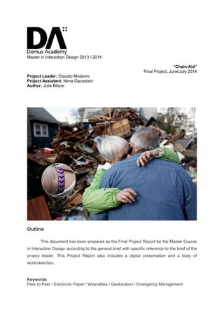
1. Master in Interaction Design 2013 / 2014
“Chain-Aid”
Final Project, June/July 2014
Project Leader: Claudio Moderini
Project Assistant: Nima Gazestani
Author: Julie Blitzer
Outline
This document has been prepared as the Final Project Report for the Master Course
in Interaction Design according to the general brief with specific reference to the brief of the
project leader. This Project Report also includes a digital presentation and a body of
work/sketches.
Keywords
Peer to Peer / Electronic Paper / Wearables / Geolocation / Emergency Management
2. Abstract/Rationale
Chain-Aid is a low-cost energy efficient wearable wristband device that can be
distributed to victims immediately following a disaster. This device will help victims to
evacuate and communicate with recovery teams in the absence of cellular service and
power outages. Chain-Aid is a forward-looking concept that explores using new and
upcoming technologies to create a peer-to-peer network for communication.
Introduction
Framework
Planning for what to do in a disaster situation is a depressing, sometimes even
fatalistic exercise, but the harsh reality of the modern world, arguably due to the effects of
global warming, is that many of us worldwide will experience a natural disaster, or several, in
our lifetime. I was in New York for both Hurricanes Irene and Sandy, but the apartments I
called home were mostly spared in both instances. Unfortunately, many family and friends
were not so lucky. In the wake of a disaster, many people live without the cellular
connectivity we’ve grown to rely on, and even without running water or power.
In disaster relief situations, helping people is about much more than communication,
but also managing and directing crowds. Victims need to know to where they can evacuate
and how. The normal signage, landmarks and infrastructure may be damaged, making
normal navigation challenging at best. Even if victims do know where shelters are located
and manage to arrive there, shelters may lack resources or sufficient space. Any design
solution to this challenge must not only tell victims where the shelter is, but assist in dividing
the crowds amongst available beds, with updated data about capacity.
As the people managing disaster relief and their respective organizations vary widely
depending on the nature and location of the disaster, I chose to focus on designing
something as a resource for victims. The design solution needs to be easy to learn for
almost anyone and not discriminate against victims who have limited experience with new
technologies.
As a by-product, I hoped to address problems I witnessed firsthand as a volunteer in
Long Beach, NY in the weeks following Hurricane Sandy, as well as reading reports and
analysis from the United Nations and various NGOs. In Long Beach, 15,000, or nearly half,
of the local residents refused to evacuate during Hurricane Sandy. Following the storm, local
officials, as well as governmental organizations and volunteers, needed to communicate with
and distribute information to all of these victims in their homes most of whom did not have
cellular connectivity, power or even running water. The city government asked volunteers
3. such as myself to hand out paper flyers to every house in the area. There has to be a more
efficient way to reach people in similar situations, given the technology available now and
anticipated in the next few years. Because of this experience, I originally was interested in
designing a volunteer management service that could be quickly installed on smartphones of
volunteers and updated with information from local governments, but seeing similar solutions
already exist and it didn’t address the core need-the victims-I changed my focus.
Objectives
The objective of this project was to use the existing and upcoming technologies, such as
personal area networks (WPAN), ambient networks, Bluetooth, and more, to explore how we
can support victims immediately after disasters. If possible, this design solution should also
be applicable to other contexts in which large crowds collect with limited connectivity, a
subject that I researched extensively for the first workshop of this master course.
Project Description
After exploring various types of forms and even using available technology on smart
phones, I chose to create a wearable wristband device. A wristband is not invasive, easily
viewed by both the person wearing it and others who may need to see signals from the
device. While smart phones are already in the hands of many victims, battery life and
compatibility are both challenges too difficult to overcome. The wristband, with an interface
powered by multi-colored electronic paper, connects to other wristbands in range via a peer-
to-peer network. The Chain-Aid band is supported by a “master” device, which can be given
to local community leaders who are likely to know their neighbors and can assist with
guidance and be in contact with the recovery and rescue teams. The wristband has four
primary features:
1. Alerts: Contact victims with emergency alert notices,
such as evacuate, find shelter, or avoid drinking
contaminated water. The wristband animates with
alert icons and when the user pinches the sides or
presses the primary surface, the alert message opens
and animates around the band until the user presses the band again. The master
device will be alerted when nearby victims do not open the alert messages.
2. Evacuation: Guide victims to meeting points and shelters. If necessary, divide
evacuees into groups to direct them to separate locations. The evacuation message
4. will first reach the master device, and that user can
specify a meeting point for evacuation. There are
three choices for meeting points: current location of
master device, a known nearby landmark, or
manually entering an address. Due to the rapidly
changing nature of environments post-disaster, the
victim with the master device is in the best position
to specify meeting points and will likely be most
aware of routes that are impassable. After the
master device user picks the meeting point,
wristbands of victims convert to a compass-like tool
that animates and helps guide them to the meeting
point. Black arrows animate around the wristband
showing the proper direction of movement and a line
above the black arrows is used to show the user if
he or she is walking in the right direction. The
spaces between the black arrows can be used for
groupings. This way, victims can look for other people with the same colors and
follow them to safety. The color groups are used to divide victims among shelters
and reduce over-crowding. The master device will provide its user a list of known
nearby victims who have not yet arrived to the meeting point.
3. SOS/Rescue: Connect with emergency rescue help through the local service similar
to 911 (USA) or 118 (Italy). The SOS function can be activated by a squeeze and
hold on the perimeter of the wristband. The wristband contains a two-way radio and
will connect the victim to the local rescue service. It will attempt to send the rescue
service the victim’s location, as well alert the master device of a nearby victim in
crisis.
4. Message: Receive non-emergency updates from local recovery headquarters. The
wristband can also receive messages that do not have the same urgency as alerts
do. The communication and interaction is the same as for alerts, but read receipts
are not sent to the master device.
The use of color throughout the design of the device is consistent and deliberate. For
alerts, the wristband changes to yellow. Red can mean both warning and stop, so it is not
used. Blue and purple are neutral colors and thus used for grouping. In compass/evacuation
5. mode, the indicator line for the color path is green when the victim is moving in the correct
direction. Vibration is used as an additional method of notification in case the user does not
see the color of the wristband changing or is sleeping and should wake up. The device will
vibrate until acknowledged for emergency alerts, but only once for non-emergency
messages.
Before deciding on the appropriate form factor or type of solution, I researched
extensively other digital projects and experiments that attempt to address disaster situations
and communication. The most immediately relevant project, was a service design concept
from frog design in collaboration with FEMA, the US’ Federal Emergency Management
Agency. This project suggested having all the tools necessary to set up disaster relief
centers immediately following a crisis.1
This project was fascinating, but did not fully address
the needs of the victims, but rather how to get relief workers to the sites as quickly as
possible. Ping, developed by Ushahidi, proposed an SMS-based system for people to get in
touch with their loved ones in times of crisis.2
In the Philippines, the Province of Albay
created an iOS app for communication in disasters for its citizens, acknowledging high risk in
the area.3
There are also some new safety-oriented wearables for everyday use and
tracking, in addition to the many existing products on the market that target elderly people at
risk. The most interesting new project is this market segment is V.ALRT from VSN Mobile,
which links to Android and iOS, as well as having one year of battery life.4
The most significant work to date in the technology for disaster relief space is among
data collection and hacking. In several instances following major disasters like the
earthquake in Haiti in 2010, Hurricanes Katrina, Irene and Sandy in the United States and
the Tsunami in Japan, new groups formed to organize and assist with data collection,
mapping, analysis and distribution. The largest of these groups are CrisisMappers, Random
Hacks of Kindness and CrisisCommons.
I then explored several new kinds of technologies that offer connectivity without the
use of cellular or Wi-Fi networks, both of which I expect to be unavailable in the chosen
design context. The revolutionary project in this space is Piratebox, a small device that
creates an anonymous peer-to-peer network for file sharing and is completely portable.5
Piratebox demonstrates the potential for peer-to-peer networking in short range that could
be used to distribute information in a chain-like structure. The UN’s Office for the
Coordination of Humanitarian Affairs (OCHA) recently began a project to formalize this kind
of data management and sharing called the Humanitarian Data Exchange (HXL), in
partnership with ReliefWeb Labs. Still in development, HXL will provide data standards,
common open sourced data sets and a large repository for quick and structured data sharing
in times of crisis.6
6. In addition to beginning with the aforementioned research and benchmarking, I went
through several steps in a design process to arrive at a synthesis and design solution. This
process is documented extensively on my blog: http://uxblitz.com/tagged/final-project. I then
developed a set of personas to assist with focusing my design thinking and analysis. The
three personas represent a connected de facto community leader, a local resident new the
area and an elderly person less familiar with technology.
With the personas and background research, I created a list of functional
requirements for the solution, which I used to arrive at the idea of making a wearable device:
1. Low-cost: Easy to mass produce with readily available materials. This project may
assume a somewhat futuristic context and use currently expensive technologies that
will be more widely available in five or ten years.
2. Energy efficient: Longer battery life that can last as long as a week or more. Can
store battery life and be activated only when needed following a disaster. This
challenge could be solved through sustainable recharging methods, like the crank-up
radios and flashlights used today. Should alert the user if battery life is very low.
3. Wearable or portable: Following a disaster, people may move to new locations, so
the device should be easy to wear or carry along.
4. Location enabled (GPS): Be able to send the victim’s location to an emergency
services station and further, display simple directions to a safer place or shelter.
5. Peer-to-peer: Connect to nearby (range TBD based on technology of choice)
devices on other victims in the community without using cellular towers that may be
out of service.
6. Online and offline connectivity: Any device may be periodically disconnected from
the network, depending on which technology is controlling the networking among the
devices. This device should store messages and send them when reconnected to the
network, as basic SMS platforms have for years.
7. Low or no infrastructure required: As infrastructure is usually damaged following a
storm, this system and service must operate without support from physical
community infrastructure such as antennae, power lines or phone lines.
7. 8. Send and receive messages: Send and receive messages both to longer range
emergency services and to locals in the area.
9. Feedback visible both to user and other people in short range: If a user sends
an “SOS” message in a crisis moment, the device should also active audio or visual
indicators that can be seen or heard by others in the immediate area who might be
able to help.
10. Coordinate efficient and fast evacuations: The messaging and communication
service should be able to direct people to quickly evacuate to a shelter, possibly
following a community leader who has a more advanced device.
11. Simple interface with no learning curve: The device should feel so simple that
anyone, even the least technology-aware locals like Ethel, can use without detailed
instructions. Must be intuitive without directions or assistance.
12. Bonus - Monitor vitals: Following an incident, victims could activate (or accept a
request to activate) monitoring of vital signs of life, likely through pulse, so that the
emergency services can know that the victims are alive and monitor communities.
13. Bonus - Simpler version that works for smartphones and mass-market
wearables: If time permits, this project will also suggest a standard for emergency
assistance and communication tools that could be pre-loaded with all consumer
mobile devices, such as smartphones and wearables.
After creating the above list of requirements, I moved on to figuring out the scenarios
and the design language for the device, then sketching on paper and even cutting the paper
as prototypes to better envision the interactions, notifications and animations. The biggest
challenge was designing a system for navigation and guidance during the evacuation
scenario. I went through several iterations and design ideas until I arrived at the modified
compass-like guide shown above. For the final presentation, I also created two animations to
show how notifications will appear on the band.
Conclusion
Chain-Aid is a somewhat futuristic concept that is based on a number of assumptions
and may not be the best solution for resources available today, but more likely for three to
five years from now. Electronic paper is a technology that has been around for years, but
8. multi-color versions that quickly animate are only in the concepting and prototype stages.
Peer-to-peer technology, which can be portable in ways similar to that of Piratebox, is also
still in development. In order to succeed, Chain-aid will need these technologies to reach a
more mature state such that costs to produce the wearable device would be low enough to
justify mass production and distribution to as many as tens of thousands of people in a
disaster relief zone. Futuristic limitations aside, Chain-aid is a hopeful approach and vision
for how technology really can “improve the human condition,” a definition of interaction
design suggested by the Interaction Design Association.7
References
1
“Bringing Disaster Relief Home.” Web. 6 February 2014.
http://designmind.frogdesign.com/blog/bringing-disaster-relief-home.html
2
“Ping.” Web. Accessed 4 June 2014. http://www.ushahidi.com/product/ping/
3
“PINDOT.” Web. Accessed 4 June 2014.
https://itunes.apple.com/us/app/pindot/id719320028?mt=8
4
“V.ALRT by VSN Mobil.” Web. Accessed 4 June 2014.
http://www.vsnmobil.com/wearables/v-alrt/
5
“Piratebox 1.0: anonymous, go-anywhere wireless file sharing.” Web. 2 June 2014.
Boingboing.net. http://boingboing.net/2014/06/02/piratebox-1-0-anonymous-go-a.html
6
“Humanitarian Data Exchange.” Web. Accessed 5 June 2014. http://docs.hdx.rwlabs.org/
7
“IxDA Mission.” Web. Accessed 28 June 2014. Interaction Design Association.
http://www.ixda.org/about/ixda-mission
Personal Blog posts
http://uxblitz.com/tagged/final-project
Pinterest board
http://www.pinterest.com/blitzer/domus-final-project-disaster-relief/