1) A wall was constructed around the British Residency in Hyderabad during the time of General Fraser from 1838 to 1852. Additional buildings like stables, wells, and gardens were also constructed within the walled complex.
2) After attacks on the Residency in 1858, the walls and bastions were strengthened with stone and concrete. Many more buildings like bungalows were added over time.
3) By the early 20th century, the area around the Residency had grown substantially and consisted of shops, houses, and infrastructure that was overseen by the Resident. It became a distinct cultural area within Hyderabad city.
This document provides information on the planning of Islamic cities, specifically Islamabad, Pakistan and Shahjahanabad, India. It discusses how Islamabad was planned on a grid iron pattern with sectors divided by wide principal roads for different land uses. Shahjahanabad was planned according to Hindu principles with the Red Fort at the most auspicious junction, major mosques including the Jama Masjid, and markets around the Friday Mosque. Both cities featured hierarchical systems of streets and mosques to serve communities.
1. The Mattanchery Palace area is impacted by multiple development regulations from various authorities due to its cultural heritage designation.
2. The AMSAR Act prohibits new construction within 100m of the palace and limits development within 300m.
3. This conflicts with plans to promote tourism and development in the area.
4. A unified development plan is needed to balance heritage conservation with equitable development rights.
The document summarizes the evolution and planning of Shahjahanabad (Old Delhi) under Mughal emperor Shah Jahan in the 17th century. Some key points:
- Shah Jahan established Shahjahanabad as the new Mughal capital in 1648, relocating from Agra due to issues with space and heat. The city was laid out based on principles of Hindu architecture and Islamic geometry.
- The city plan centered around the Red Fort, with major streets and markets radiating outward. Open spaces, gardens, and the Jami Masjid mosque were also incorporated into the design.
- Over time, the British took control of the city and imposed changes. However, the
Under colonial rule in the late 18th century, Calcutta, Bombay, and Madras rose as Presidency cities and centers of British power, while many smaller cities and trading centers declined as trade shifted. Old regional powers also collapsed when local rulers were defeated. This led to the de-urbanization of cities like Machlipatnam, Surat, and Seringapatnam in the 19th century. After the 1857 rebellion, the British demolished parts of Shahjahanabad and filled canals to erase Delhi's Mughal past. They began constructing a new capital, New Delhi, as a contrast to the old city with broad streets and planned neighborhoods. Partition in 1947 led to massive population exchanges, as
The Mughal Empire ruled northern India from 1526 to 1707. Some key developments during this period included the construction of monumental architecture and cities like Agra and Delhi. Fatehpur Sikri was entirely planned by Akbar, and many gardens were developed, including Kabul Bagh and Shalimar Bagh. The Indus Valley civilization spanned from 3000 BC to 1300 BC in modern-day Pakistan and northwest India. Major cities like Mohenjo-Daro had advanced systems of town planning, with streets in a grid pattern and houses built around central courtyards. They developed new techniques in crafts and metallurgy. The Indus Valley culture collapsed due to an unknown catastrophe.
The document discusses the history of town planning in ancient India, beginning with the Indus Valley Civilization around 3000 BCE. It describes how the cities of Mohenjo-Daro and Harappa exhibited advanced systems of town planning, with organized layouts of streets, drainage, and buildings. Subsequent periods, including Vedic, Buddhist, medieval, Mughal, and British rule, all continued developing principles and practices of town planning across various cities and settlements in India.
The document discusses Islamic principles of city planning and the design of Shahjahanabad, a historic city in India. Some key points:
- Islamic city planning is guided by principles from the Quran and hadith, including not causing harm, respecting privacy, sharing water, and locating sources of smell/noise away from mosques.
- A typical Islamic city layout centers around a grand mosque, with souqs (markets), residential quarters, and a citadel. Narrow streets separate public and private spaces.
- Shahjahanabad was planned according to Hindu texts, with the Red Fort at the junction of its two main axes along the Yamuna River. It had an elaborate infrastructure including the fort
1. Delhi has a long history as a settlement dating back to the 2nd millennium BC. It has been ruled by many empires and dynasties over the past millennium who have developed it as their capital. 2. Over time, seven main cities have been developed in Delhi - Qila Rai Pithora, Mehrauli, Siri, Tughlakabad, Ferozabad, Shergarh, and Shahjahanabad. 3. Shahjahanabad, built in the 1600s, was the seventh major planned city and it included key features like the Red Fort, Jama Masjid, Chandni Chowk and a walled city.
The document provides an overview of the evolution of town planning in India from ancient to modern times. It describes the major periods of development:
- Ancient period saw the rise of the Indus Valley civilization and planned cities like Harappa and Mohenjo-Daro. Vedic and Buddhist texts also discussed early town planning principles.
- Medieval towns were dominated by churches and castles and tended to be irregular in layout for defensive purposes.
- Mughal cities like Agra, Delhi, and Shahjahanabad were redesigned with gardens and parks incorporated.
- The British established colonial cantonments and hill stations outside existing Indian towns during the pre-independence period. New Delhi was
The document discusses the town planning of Delhi, including its geography, history of urbanization, population growth trends, and master plans implemented over time to accommodate increasing population. It provides details on the planning and development of Shahjahanabad during Mughal rule in the 17th century, including the layout of key areas like the Red Fort, Jama Masjid mosque, streets, neighborhoods, gardens and city walls. It also briefly outlines the subsequent development of Lutyens' Delhi after Delhi became the capital under British rule in the early 20th century.
Kochi, also known as Cochin, is a major port city located in Kerala, India. It formed in 1341 due to flooding of the Periyar River. Kochi was an important spice trading center from the 14th century onwards, trading with Arab merchants. The city has a diverse, multicultural population and was historically influenced by Portuguese, Dutch, and British colonizers. It has a hot, humid climate with high rainfall and temperatures ranging from 22 to 34 degrees Celsius.
George Town is the historic core area of Chennai that has experienced traffic congestion, poor infrastructure, and lack of land due to commercial activities and narrow streets. The Chennai Metropolitan Development Authority has undertaken several redevelopment strategies for George Town, including removing encroachments, shifting wholesale markets to Koyambedu to reduce congestion, and road widening projects while protecting heritage buildings. Lessons for redeveloping other congested areas include promoting mixed land use and improving infrastructure.
Growth of cities and towns during medieval indiaPrabhleen Arora
This document discusses the growth of cities and towns in medieval India. It explains that towns first developed around religious sites, seats of government, and as commercial centers along trade routes. Cities grew substantially during the Sultanate period and further in the 16th-17th centuries. Larger towns had markets, manufacturing of goods, and a hierarchy with smaller towns and villages. However, the establishment of the East India Company in the late 17th century negatively impacted urban industries and economic development.
This document provides an overview of the evolution of town planning in India from ancient to modern times. It describes the key features of towns during different historical periods, including the Indus Valley civilization, Vedic period, Buddhist period, medieval period under the Mughals, pre-independence period under British rule, and post-independence period. Important towns that emerged during each period are highlighted, along with the influences of rulers and planning approaches during that time.
Jodhpur, located in the state of Rajasthan, India, was founded in 1459 by Rao Jodha, chief of the Rathore clan. The city served as the capital of the kingdom of Marwar and was ruled by the Rathore clan of Rajputs until it merged with India in 1947. Some of Jodhpur's notable attractions include the 15th century Mehrangarh Fort, Umaid Bhawan Palace, Jaswant Thada memorial, and the Clock Tower. The climate is hot and dry for most of the year, and the city is known as the "Blue City" due to the traditional practice of painting houses blue.
Settlement pattern of town (Varanasi) brief history of city evolve , settlement of institution and residents, concepts of the main ghats , master plan of Varanasi
The document provides details about the urban planning and architecture of Fatehpur Sikri, the capital city of the Mughal Empire built in the late 16th century. It was carefully planned with buildings oriented on a north-south axis and organized based on terrain. Key complexes included the Mosque Complex, Imperial Complex, and public areas. The Imperial Complex featured buildings like the Diwan-i-Khas and Panch Mahal with intricate designs, demonstrating Akbar's vision and the skilled craftsmanship of the time.
Filling in the gaps historic percents of 20th centuryShilpa Jain
This document provides an overview of the historic neighborhood of Daryaganj in Delhi, India. It discusses how Daryaganj served as an important market area and residential precinct during Mughal rule. While it lost prominence over time, it remained an important urban area. In the 20th century, it became a center for schools, hospitals, and residences of wealthy families. The document argues for recognizing and conserving Daryaganj's cultural heritage as development pressures grow and its role in Delhi's history is at risk of being lost.
Kolkata was originally three villages that were developed by the British East India Company into a colonial city and capital of British India until 1911. It grew rapidly in the 19th century as a center of both British imperial rule and Indian cultural awakening known as the Bengal Renaissance. Problems from rapid urbanization began affecting Kolkata in the 1930s and it remains an example of the challenges faced by developing world cities.
Kolkata past and present -Rajorshi Chatterjee_SPA_Delhi_Urban planningRAJORSHI CHATTERJEE
A brief discussion on Calcutta and its city growth. The city extended manifold after the Colonial rule, which defines the urban character and built fabric of the city. At the same point of time we need proper planning insights to this city for its future growth and development.
Ancient Indian cities had sophisticated town planning systems based on Vedic texts. Towns were classified by size, from small villages to large capital cities, and by shape, including rectangular, square, circular and mystic symbolic designs. Larger cities had defined areas for temples, tanks, palaces, markets and residential zones for different castes. Streets were arranged in a grid pattern with widths specified in ancient units of measurement. Overall town planning principles focused on providing resources, security and social organization according to religious scripts.
Varanasi is an ancient city located in Uttar Pradesh on the banks of the Ganges River. It has a humid subtropical climate with hot summers and cool winters. The city has experienced significant growth over time, from its traditional core established by the 2nd century BC to expansion during the British colonial period and contemporary development. Varanasi is renowned for its religious importance to Hindus and 84 ghats along the Ganges where religious ceremonies are performed. The city also has a rich cultural heritage seen in its arts, crafts, architecture and educational institutions like Banaras Hindu University.
New Delhi was designed in the early 20th century to serve as the capital of British-controlled India. It was designed by British architects Edwin Lutyens and Herbert Baker in a grandiose colonial style inspired by Mughal architecture. Construction began in the 1920s on a symmetrical grid layout with wide boulevards, bisected by a central axis containing government buildings. Some of the most prominent architectural buildings included Rashtrapati Bhavan, the residence of the President of India, and the circular Parliament House, as well as Connaught Place, a commercial hub, and memorial structures like India Gate.
Colonial cities in India developed under European colonial rule between the 16th and 20th centuries. Chennai, originally known as Madras, is highlighted as a case study. It began as a small trading settlement established by the British East India Company in 1639. Over centuries, the British expanded control of the area and merged surrounding villages to form the modern city of Chennai. Colonial development transformed Chennai into an important political and economic center, establishing institutions and infrastructure that supported its growth into a major city.
1. The document discusses repairs and additions made to the Truss roof and Durbar Hall of a building in 1882, including the addition of a mezzanine floor and new toilet blocks.
2. It describes how the building was adapted after becoming a university, with ad-hoc additions made to accommodate new functions like departments, laboratories, and administrative areas. Some old recreational spaces were also converted.
3. The document analyzes the current state of the building, noting neglected areas, abandoned spaces lacking light and ventilation, and the need for electrical system upgrades.
1. The document discusses the lower ground floor of a former British residency that is now used as a college. It notes that some enclosed access ways have resulted in redundant and abandoned spaces.
2. It describes how one well-maintained part of the western wing has retained original circulation corridors, but that the collapse of the roof in other parts has made them abandoned.
3. The planning of living spaces in the wings needs review as several large halls are enclosed by partitions for more classrooms, but the use assigned to spaces is sometimes inappropriate given the historic nature of the building.
The document discusses functional assessments of the upper ground floor of a building. It notes that 1) the durbar hall is currently redundant after being used for classrooms and offices, 2) the eastern rooms house staff but need furniture and service upgrades, and 3) the larger western wing halls have been used as classrooms but have insensitive additions like nailed blackboards and graffiti. It also discusses 4) the need to replan sensitive wooden jali panel and partition wall additions dividing spaces, and 5) how added toilet blocks, water tanks, and past repairs have damaged the roof slabs rendering western parts unusable.
The document summarizes alterations that have occurred at the Osmania University College for Women site, which was formerly the British Residency in Hyderabad. It notes that [1] the original entrance gateway and site access were altered, changing the relationship with the immediate context. [2] Several historic structures like gateways, burial grounds, and fortification walls remain neglected without a maintenance plan. [3] New structures have been built in an ad hoc manner incongruous to the historic surroundings due to a lack of holistic planning. The document then examines specific additions and alterations to the site and its buildings over time.
This document lists primary and secondary resources for understanding the former British Residency in Hyderabad, now the site of Osmania University College for Women. The primary sources include correspondence, reports, and records from the British Residency in Hyderabad and other archives. The secondary sources include unpublished reports, theses, publications, and books on the history of the British Residency in Hyderabad.
9 12 Historical Evolution Last Layer Of Womens Collegesarath2008
The Women's College traces its origins to the Nampally Girls School in 1924. It was initially housed in the school before relocating to temporary locations due to increasing student numbers. In 1949, the college was granted permission to move to the vacant British Residency building, providing spacious grounds that delighted students. Over the following decades, the college adapted well to its new campus, using the Residency's original features of privacy and security. It became a pioneer in women's education in Hyderabad through expanding its course offerings.
5 8 Historical Background And Description About The Buildingsarath2008
1) The construction of the building started in 1803 and was still incomplete in 1806 according to a report, though it was occupied later.
2) The principal front features a large Corinthian portico with statues and the company's arms in the center pediment.
3) The building consists of a basement storey and two floors above, connected by wings, with the south front having a double height Doric colonnade balcony.
1 4 Introduction And Historical Back Groundsarath2008
The document provides background information on the conservation management plan for the former British Residency site in Hyderabad, now occupied by the Osmania University College for Women. It discusses the site location and ownership. The historical background section outlines that the site was home to the British Resident from 1805 to 1949 and was transferred to Osmania University in 1949. It describes the early establishment of the British Residency in Hyderabad in the early 19th century, including the construction of the original residency buildings. The document also lists the members involved in developing the conservation management plan.
The document summarizes additions and alterations made to the Osmania University College for Women site, formerly the British Residency in Hyderabad. Key points include:
1) The original entrance gateway and drainage system of the site have been altered or fallen into neglect.
2) New structures and additions like toilets, stairs, and a canteen block have been built within the site in an ad-hoc manner, incongruous with the historic surroundings.
3) Modifications were made to the building post-1949 to accommodate the university, including demolishing colonnades, enclosing corridors, and adding services - affecting the integrity of the site.
The document discusses functional assessments of the upper ground floor of a building. It notes that 1) the durbar hall is currently redundant after being used for classrooms and offices, 2) the eastern rooms house staff but need furniture and service upgrades, and 3) the larger western wing halls have been used as classrooms but have insensitive additions like nailed blackboards and graffiti. It also discusses 4) the need to replan sensitive wooden jali panel and partition wall additions dividing spaces, and 5) how added toilet blocks, water tanks, and repairs have damaged the roof slabs in parts of the main block.
The document outlines a conservation management plan for the Osmania University College for Women located in the former British Residency in Hyderabad. It was created by a project team consisting of B. Sarath Chandra, Tapan Mittal-Deshpande, Niket Deshpande, Syed Zahid Ali Akhtar, and B. Venkat Rao. The plan has multiple chapters that will assess and maintain the historic building.
You can easily change/correct a name on your flight ticket under the American Airlines name change policy. The airline provides multiple online and offline modes to place a name change request. To learn more about how to change a name on American Airlines ticket, you can directly approach the airline’s customer support. Moreover, you can connect with a flight expert at +1-866-738-0741 for quick assistance.
Discovering Egypt A Step-by-Step Guide to Planning Your Trip.pptImperial Egypt
Travelling to Egypt is like stepping into a time capsule where the past and present coexist, offering a unique blend of history, culture, and stunning landscapes.
See more: https://imperialegypt.com/tour-packages/
Un viaje a Buenos Aires y sus alrededoresJudy Hochberg
A travelogue of my recent trip to Argentina, most to Buenos Aires, but including excursion to Iguazú waterfalls, Tigre, and Colonia del Sacramento in Uruguay
What Outdoor Adventures Await Young Adults in Montreal's Surrounding NatureSpade & Palacio Tours
Experience Montreal's vibrant culture and thrilling outdoor adventures. From hiking scenic trails at Mont-Saint-Bruno to kayaking the Saint Lawrence River, there's something for every adventurous young adult. Explore street art, camp under the stars, and immerse yourself in nature's beauty just beyond the city's bustling streets.
Ibiza, situated in the Balearic Islands, stands out as a destination that encompasses everything: stunning landscapes, hidden gems to explore, a vibrant social scene, rich cultural life, and exceptional gastronomy. Opting for ‘Ibiza Rent A Boat’ to experience an unforgettable vacation on the White Island is certainly worthwhile, prompting a deeper exploration of the unique and fascinating aspects of Ibiza.
What Challenges Await Beginners in SnowshoeingSnowshoe Tahoe
Discover the exhilarating world of snowshoeing through our presentation, highlighting the challenges faced by beginners. From physical exertion to technical finesse and braving harsh winter conditions, each step in the snow brings new obstacles and unforgettable adventures. Embrace the challenge and conquer the winter wonderland with confidence!
How do I plan a Kilimanjaro Climb?
Planning to climb Mount Kilimanjaro is an exciting yet detailed process. Here’s a step-by-step guide to help you prepare for this incredible adventure.
Prepare for cold weather rafting with proper gear: layering for warmth, insulated headgear, gloves, waterproof footwear, and essential accessories like sunglasses and sunscreen. Prioritize safety with a life jacket and maintain gear for optimal performance. Stay warm, dry, and ready for adventure on the rapids!
Nature of the task 1. write a paragraph about your trip to dubai and what ar...solutionaia
1. write a paragraph about your trip to dubai and what are the facts responsible for the heavy rainfall in dubai that caused havec ?
2. mention any five major tourist attaction of dubai
Mathematics: a student a visit her family her father converted Rs. 1,15,000 inr currency for dubai airport theexpedite in the trip is given below
1. Curreny name of India and dubai
2. Conversions amount
3. Total Converted amount
4. cost of food
5. cost of sightseeing
6. cost of shoping
7. cost of saving
The Ultimate Travel Guide to Hawaii Island Hopping in 2024adventuressabifn
island hopping in Hawaii. This magical place offers a number of experiences, as each island has its own charm. Do you love adventure? Then, hike through volcanoes or kayak along an amazing coastline. If you want relaxation, then Hawaii is perfect because it has the most amazing beaches. In this blog, I will help you make an itinerary for your Hawaii Island Hopping. Every island offers something special. The Big Island offers some of the most perfect volcanoes as well as stargazing. Maui will pamper you with beaches and luxury. Kauai has some of the most lush rainforests with dramatic cliffs, and Oahu can offer a taste of city life and historical significance.
Golden Gate Bridge: Magnificent Architecture in San Francisco | CIO Women Mag...CIOWomenMagazine
The famous suspension bridge connects the city of San Francisco to Marin County in California. Golden Gate Bridge carries both U.S. Route 101 and California State Route 1 across the strait and is about one mile wide. In this article, we will explore the history and significance that have shaped the iconic monument it is known as today.
Our excursions in tahiti offer stunning lagoon tours, vibrant marine life encounters, and cultural experiences. We ensure unforgettable adventures amidst breathtaking landscapes and serene waters. For more information, mail us at tracey@uniquetahiti.com.
Beyond the mountains, a tour in Nepal reveals a vibrant tapestry of cultural heritage. The Kathmandu Valley, a UNESCO World Heritage Site, boasts an array of ancient temples, stupas, and palaces. Durbar Squares in Kathmandu, Bhaktapur, and Patan are treasure troves of medieval art and architecture.
Explore Architectural Wonders and Vibrant Culture With Naples ToursNaples Tours
Discover the historical gems and vivid culture of Naples with our guided tours. From the vivid narrow streets of Spaccanapoli to the ancient ruins of Pompeii, the city offers a mixed bag of adventurous experiences. Book your tickets today https://www.naples.tours/ and experience the best of Naples!
Explore Architectural Wonders and Vibrant Culture With Naples Tours
13 16 Historical Layers Evolution Maps 1803 1949
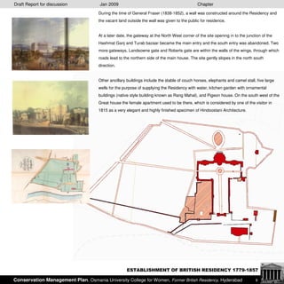
1. Draft Report for discussion Jan 2009 Chapter
During the time of General Fraser (1838-1852), a wall was constructed around the Residency and
the vacant land outside the wall was given to the public for residence.
At a later date, the gateway at the North West corner of the site opening in to the junction of the
Hashmat Ganj and Turab bazaar became the main entry and the south entry was abandoned. Two
more gateways, Landsowne gate and Roberts gate are within the walls of the wings, through which
roads lead to the northern side of the main house. The site gently slopes in the north south
direction.
Other ancillary buildings include the stable of couch horses, elephants and camel stall, five large
wells for the purpose of supplying the Residency with water, kitchen garden with ornamental
buildings (native style building known as Rang Mahal), and Pigeon house. On the south west of the
Great house the female apartment used to be there, which is considered by one of the visitor in
1815 as a very elegant and highly finished specimen of Hindoostani Architecture.
ESTABLISHMENT OF BRITISH RESIDENCY 1779-1857
Conservation Management Plan, Osmania University College for Women, Former British Residency, Hyderabad 9
2. Draft Report for discussion Jan 2009 Chapter
The wall was further strengthened with bastions and stone walls after the attack on the Residency in
1858 (See pic no..) and was made concrete in 1891.
Many buildings were added through the course of time as per the requirements such as the First
assistant bungalow, second assistant bungalow, the military secretary bungalow, the Residency
Surgeons bungalow, the escort officer’s bungalow etc.
Extensive repairs were done to the roof of the building in 1888. Events such as the attack on the
Residency in 1858, fire accident in the wings (printing press) and the natural calamities such as 1908
floods in the river Musi led to the extensive transformations.
STRENGTHENING OF THE BRITISH RESIDENCY 1857 - 1900
Conservation Management Plan, Osmania University College for Women, Former British Residency, Hyderabad 10
3. Draft Report for discussion Jan 2009 Chapter
THE RESIDENCY AND ITS CONTEXT: 1915
The construction of the British Residency on the North banks of the
River Musi, was a very important event for the city of Hyderabad.
Following the construction of this residency, there came into
existence around it a cluster of shops and dwelling houses of the
bonafide subjects of the Ruler of the State. Over this area[1] the
Resident was accorded by the Nizam’s government “unreserved
power, jurisdiction in civil and criminal matters”. This new
settlement went on gaining popularity and a considerable
population started settling here.
It became the chief suburb of the city of Hyderabad covering a large
tract of ground to the North and North-East of the city outside
Afzalgunj was known as Chaderghat. This suburb of Chaderghat
consisted of “the Residency, the Bank of Bengal, the Clubs, the
post office, St Georges church, the old and new cemeteries, the
Roman Cathedral, the public works office, and the majority of
dwelling houses belonging to the Christian employees of His
Highness the Nizam’s government. The suburb was new and
increasing[2] in size yearly. It had a municipality of its own, which
looked after the public conveniences like roads, etc, very well.
The Residency area covered three bazaars Isa Miah, Hashmat Ganj
and Kasim Gunj. A big portion of Turab bazaar was also included
in it. Hashmat Gunj contained many bungalows of the business
community, and Turab Bazar has the Bank of Bengal located in it.
The Residency is a mile away from the main city towards the
North east. The area is not less than 4 miles and according to the
census of 1901, it population was 16,904.
1] In all the places under the control of the Resident are the stations of the Hyderabad
Contingent the bazaars lying round the Hyderabad Residency, the G.I.P railway posts of
Gulbargah and Raichur; and indeed the whole railway itself whether constructed or under
construction, where it traverses the Hyderabad Country and the Military Cantonment of
Secunderabad
[2] The growth of the areas around Residency is due to the following reasons:
The administration of the new settlement was more efficient and hence enjoyed comparative
peace and security. In contrast to the civil administration which was chaotic in Hyderabad
and especially in its suburbs who therefore migrated from Karwan to the Residency Area,
because of the security it offered.
Secondly, the composition of those new settlements had of course, a prominent element of
Europeans and Eurasians with overtones of Christian cultural strains. The development of
the Residency area as a distinct cultural pocket was symbolic of British political
ascendancy.
Conservation Management Plan, Osmania University College for Women, Former British Residency, Hyderabad 11
4. Draft Report for discussion Jan 2009 Chapter
In 1925, Public Works Department constructed an annex (Kitchen and dining) which completely
ruined the grand views while approaching from the Empress gateway. The architectural quality of
the space in between the main house, wings and the Empress gate was lost.
The main house is the principal building in what is called the Residency, and is occupied by the
Resident himself, with the guest that he may have putting up with him.
On the grounds are quartered a detachment of cavalry who make the body guard of the resident
on state occasions, and a large number of native soldiers of the line, who furnish the details for
day and night guards at all points of Residency.
BRITISH RESIDENCY 1900 - 1949
Conservation Management Plan, Osmania University College for Women, Former British Residency, Hyderabad 12