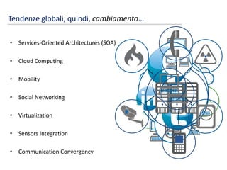
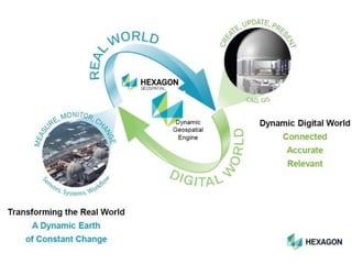
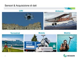
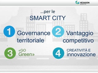
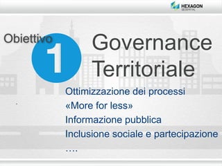
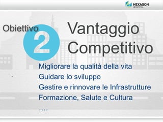
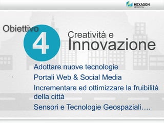
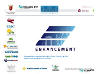
Smart City Conference
Smart Cities-Metodo RINASCIMENTO 2.0
e soluzioni geospaziali
Claudio Mingrino
Executive Director
Europe, Middle East & Africa
Hexagon Geospatial
Roma, 24 Giugno 2014
2
Agenda
1. Il mercato “Geospatial”: situazione ed evoluzione
2. Trend tecnologici ed applicativi
3. Hexagon
4. Importanza della tecnologia “Geospatial” per le Smart Cities
5. Ruolo di Hexagon in RINASCIMENTO 2.0
3
Il mercato “Geospatial” 2012 - 2017
Notes:
 Market Research based on 2012 ARC Advisory Group Report
 Software, maintenance and services
4
Crescita per segmento industriale
77%CAGR in
IT spending(in Africa e Medio Oriente)
1/3di tutte le apparecchiature
mobile in
EMEA
SMART
PHONES
> 1
tablet in uso
nel 2017
MILIARDO
(40% in EMEA)
nel 2020
di SENSORI CONNESSI
MILIARDI
ogni giorno
,500,000,000,000,000,00
0
bytes
che produrranno
2.5 EXABYTES
2o
THOUSANDQUINTILLION QUADRILLION MILLIONTRILLION BILLION
nel 2020
83%
PIU’ DELLA META’
Delle proprie transazioni IT sarà
effettuato in “cloud computing”
degli IT Managers in EMEA ha
dichiarato che
75%
MANUTENZIONE
è relativa a
DELLA SPESA GLOBALE IN IT
UPGRADE&(West Europe)
Tendenze globali, quindi, cambiamento…
• Services-Oriented Architectures (SOA)
• Cloud Computing
• Mobility
• Social Networking
• Virtualization
• Sensors Integration
• Communication Convergency
SOA
Enterprise
Technology
Governance
13
I cambiamenti regolano il mondo
14
Noi stessi siamo sensori e risolutori di problemi
15
I nostri sensori: Vista
16
I nostri sensori: Tatto
17
I nostri sensori: Olfatto
18
I nostri sensori: Gusto
19
I nostri sensori: Udito
20
Noi Identifichiamo, Organizziamo, Analizziamo e Decidiamo
24
REAL
World
Events
DIGITAL
World
Models
Un Flusso continuo
di Informazioni
fuses the Real World
(as is/as built)
with the Digital World
(as planned/
as designed)
SENSOR
Fusing the Real and Digital World
SOFTWARE
L’Ecosistema Hexagon:
per connettere il mondo Reale e quello Digitale
25
Per proteggere gli investimenti degli Utenti
Sensor and
Video Integration
Social MediaCloud Computing
3-Dimensional
Modeling
Mobile Computing
26
Driving the Spatial Revolution
From Data Collection to Dynamic Geospatial Content
27
Sensori & Acquisizione di dati
Terrestrial Mobile
AirborneUAV
Mobile
Verso le soluzioni SOFTWARE
29
…di ogni tipo
30
In conclusione, permettere di fondere tutti i componenti
tecnologici…
31
… sfruttando il cambiamento e trasformandolo in
Azione
32
L’ecosistema
…per le
SMART CITY
Governance
territoriale
Vantaggio
competitivo
«GO
Green»
CREATIVITÀ E
innovazione
Obiettivo
Governance
Territoriale
Ottimizzazione dei processi
«More for less»
Informazione pubblica
Inclusione sociale e partecipazione
….
Vantaggio
Competitivo
Obiettivo
Migliorare la qualità della vita
Guidare lo sviluppo
Gestire e rinnovare le Infrastrutture
Formazione, Salute e Cultura
….
«GO
Green»
Obiettivo
Sostenibilità ambientale
Ridurre gli sprechi energetici
Gestire il ciclo delle acque e dei rifiuti
Verso una città «ecologica»
….
Creatività e
Innovazione
Obiettivo
Adottare nuove tecnologie
Portali Web & Social Media
Incrementare ed ottimizzare la fruibilità
della città
Sensori e Tecnologie Geospaziali….
39
Empower Natural HAbitat with Non Carbon Emitting Mobility
for Electronically Networked Tourism
per
«GEOSPATIAL
Advantage»
CREATIVITÀ E
innovazione
«GOING
Smarter»
Tecnologia per
integrare
I fattori chiave per il successo
Conclusioni
Grazie
claudio.mingrino@hexagongeospatial.com

GWT 2014: Smart City Conference - 02 Introduction to Smart City Conference

Editor's Notes

  • #13 Amazon E2C, NASA Nebula
  • #14 And when things change, as they always do we our senses or our ‘sensors’, that immediately take snapshots of the environment around us so that we can process what’s happening and respond and take action accordingly.
  • #16 We Can See
  • #17 We Can Touch
  • #18 We Can Smell
  • #19 We Can Taste
  • #20 We can Hear
  • #21 And our senses provide that ‘data’…and a lot of Data for our perception. And it’s our perception that does the organization, identification and interpretation of all this sensory information. And using our perception, we construct representations using the information available. Then we decide!
  • #25 Fusing the Real and Digital Worlds Ie the world we live in and its digital reflection We need to close the productivity gap in order to increase efficiency and productivity The world is not build of single customers but of ecosystems that integrate technology between sectors and so gain synergies. Hexagon offers the possibility to use smart data to make smart decisions.
  • #26 Intergraph is determined to stay ahead and become an industry innovator. We will protect your investment in Intergraph technology by continuing our legacy of innovation in applications that improve your service delivery capabilities. We will promote the fusion of sensor, ground, and mobile technologies with geospatial software applications – especially in emergency response and surveillance. We will continue to seek ways to integrate emerging technologies – such as cloud computing, Web services, sensor integration, mobile computing, and social media – … to name a few, to fuel new uses of data that help you gain real knowledge for mission-critical decision-making.
  • #28 Field Mapping Leica Zeno – Hand held Mobile OS Leica CS25 – Full Windows 7 Ultimate Rugged Mobile Device Terrestrial Sensors – Laser based ranging. Total Stations (TS30) - .5 seconds 2mm accuracy HDS (Scan Station p20) – 1 million points per second, a range of about 120 meters
  • #32 So that we can ultimately act and experience and continue to participate in the changing world around us. We Process, Interpet and then We Act!