SlideShare a Scribd company logo
1 of 18
Download to read offline
GEOGRAPHY CAPSULE
1 www.bankersadda.com | www.sscadda.com | www.careerpower.in | ADDA247.COM | defence.adda247.com
GA POWER CAPSULE FOR GEOGRAPHY FOR DEFENCE EXAMS 2018-19
Earth Solar System
Earth solar system consists of :
• The Sun • The Planets
• Dwarf Planets & countless fragments of left – overs called
asteroids, meteors, comets & satellites of the planets (Called
small solar system Bodies).
Solar System Some Facts
• Biggest Planet : Jupiter
• Smallest Planet : Mercury
• Nearest Planet to Sun : Mercury
• Farthest Planet from Sun : Neptune
• Nearest Planet to Earth : Venus
• Brightest Planet : Venus
• Brightest star after Sun : Sirius
• Planet with maximum satellites: Jupiter
• Coldest Planet : Neptune
• Hottest Planet : Venus
• Heaviest Planet : Jupiter
• Red Planet : Mars
• Biggest Satellite : Ganymede
• Smallest Satellite : Deimos
• Blue Planet : Earth
• Morning/Evening Star : Venus
• Earth's Twin : Venus
• Green Planet : Neptune
• Planet with a big red spot : Jupiter
• Lord of the Heavens : Jupiter
• Greatest Diurnal Temperature : Mercury
Earth Latitude & Longitude
Earth Latitude
• Imaginary lines drawn parallel to the equator. Measured as
an angle whose apex is at the centre of the earth.
• The equator represents 0° latitude, while the North Pole is
90° N & the South Pole 90° S
• 23½° N represents Tropic of Cancer while 23½° S
represents Tropic of Capricorn.
• 66½° N represents Arctic Circle while 66½° S represents
Antarctic Circle.
• There are total 181 latitudes including the equator. Each
parallel of latitude is a circle, but they are not equal.
• The circle becomes smaller toward`s the poles. Equator is
the ‘Greatest Circle’ that can be drawn on the earth’s surface.
• The distance between any two parallels of latitude is always
equal.
• 1 degree lat. = 111km.
Earth Longitude
• It is the angular distance measured from die centre of the
earth. On the globe the lines of longitude are drawn as a
series of semicircles that extend from the North Pole to the
South Pole through the equator. They are also called
meridians.
• The distance between any two meridians is not equal.
• At the equator, 1 degree = 111 km. At 30°N or S, it is 96.5
km. It goes on decreasing this way until it is zero at the
poles.
• There are 360 meridians of longitude. The prime meridian is
a longitude of 00, passing through the Royal Observatory at
Greenwich near London.
• This meridian is taken by geographers to divide the earth
into the eastern & the western hemispheres.
• Each meridian of longitude is a semi-circle. 180° meridian
(International Date Line) lies exactly opposite to 0°
meridian. Such points are called Antipodal Points.
• The earth is divided into 24 longitudinal zones, each being
15° or 1 hour apart in time (4 minutes / degree).
Longitude & Time
• Places that are on the same meridian have the same local
(sun) time. Since the earth makes one complete revolution of
360° in 24 hours, it passes through 15° in one hour or 1° in 4
minutes.
• The earth rotates from west to east, hence places east of
Greenwich see the sun earlier & gain time whereas places
west of Greenwich see the sun later & lose time.
• India, whose longitudinal extent is approx. 30°, has adopted
only one time zone, selecting the 82.5°E for the standard
time which is 5 hours & 30 minutes ahead of GMT
(Greenwich Mean Time).
International Date Line
• It is the 180° meridian running over the Pacific Ocean,
deviating at Aleutian Islands, Fiji, Samoa & Gilbert Islands. It
is a zig-zag line
• Travelers crossing the Date Line from west to east (i.e., from
Japan to USA) repeat a day & travelers crossing it from east
to west (i.e., from USA to Japan) lose a day.
Important Parallels of Latitude
1. The Tropic of Cancer: It is in the northern hemisphere at an
angular distance of 23 1/2° (23°30’N) from the equator.
2. The Tropic of Capricorn: It is in the southern hemisphere at
an angular distance of 23 1/2° (23°30’S) from the equator.
3. The Arctic Circle: It lies at a distance of 66 1/2° (66°30’N)
north of the equator.
4. The Antarctic Circle: It lies at a distance of 66 1/2° (66°30’S)
south of the equator. There are two solstices each year, called
the Summer Solstice & the Winter Solstice.
Summer Solstice: The day of 21st June when the sun is
vertically overhead at the Tropic of Cancer (23°30’N). Longest
day in Northern Hemisphere.
Winter Solstice: The day of 22nd December when the sun is
vertically overhead at the Tropic of Capricorn (23°30’S).
Shortest Day in Northern Hemisphere.
Meridians of Longitude
The semi-circles running from pole to pole or from north to
south are known as meridians of longitude & distance between
them is measured in degrees of longitude. Greenwich Meridian
or Prime Meridian with a value of 0° longitude serves as a
common base for numbering meridians of longitude lying on
either side of it — east as well as west. There are 360 meridians
including Prime Meridian. Each degree of a longitude is divided
into sixty equal parts, each part is called a minute. Each
minute is again divided into sixty equal parts, each part being
called a second.
GEOGRAPHY CAPSULE
2 www.bankersadda.com | www.sscadda.com | www.careerpower.in | ADDA247.COM | defence.adda247.com
Local Time : Local time of any place is 12 noon when the sun is
exactly overhead. It will vary from the Greenwich time at the
rate of four minutes for each degree of longitude.
Greenwich Mean Time : The time at 0° longitude is called
Greenwich Mean Time. It is based on local time of the meridian
passing through Greenwich near London.
Indian Standard Time : It is fixed on the mean of 82 1/2°E
Meridian, a place near Allahabad. It is 5 1/2hours ahead of
Greenwich Mean Time.
Facts about earth
• The Earth also called Blue Planet. It is the densest of all
planets.
• Earth Circumference: 40,232 Kilometers.
• Earth Area: 510 million Square Kilometers
• Average distance from sun: 149 million Kilometers.
• Earth Perihelion: Nearest position of earth to sun. The earth
reaches its perihelion on January 3 every year at a distance of
about 147 million-Kilometers.
• Aphelion: Farthest position of earth from sun. The earth
reaches its aphelion on July 4, when the earth is at a distance of
152 million Kilometers.
• The shape of the earth is oblate spheroid or oblate ellipsoid
(i.e. almost spherical, flattened a little at the poles with a slight
bulge at the centre).
Types of Earth Movements:
1. Rotation or daily movement.
2. Revolution or annual movement.
Earth Rotation
• Spins on its imaginary axis from west to east in 23 hrs, 56 min
& 40.91 sec.
• Rotational velocity at equator is 1667 Kilometers/h & it
decreases towards the poles, where it is zero.
Earth’s rotation results in
i. Causation of days & nights;
ii. A difference of one hour between two meridians which are
15° apart;
iii. Change in the direction of wind & ocean currents; Rise & fall
of tides everyday.
iv. The longest day in North Hemisphere is June 21, while
shortest day is on 22 Dec (Vice-versa in S.Hemisphere).
• Days & nights are almost equal at the equator.
Earth Revolution
• It is earth’s motion in elliptical orbit around the sun. Earth’s
average orbital velocity is 29.79 Kilometers/s.
• Takes 365 days, 5 hrs, 48 min & 45.51 sec. It results in one
extra day every fourth year.
• Revolution of the earth results in
i. Change of seasons
ii. Variation in the lengths of days & nights at different times of
the year
iii. Shifting of wind belts
iv. Determination of latitudes.
Earth Eclipses
Earth Lunar Eclipse
 When earth comes between sun & moon.
 Occurs only on a full moon day. However, it does not occur
on every full moon day because the moon is so small & the
plane of its orbit is tilted about 5° with respect to the plane
of the earth’s orbit. It is for this reason that eclipses do not
occur every month.
 This light is red because the atmosphere scatters the other
colors present in sunlight in greater amounts than it does
red.
Earth Solar Eclipse
A solar eclipse is a type of eclipse that occurs when the
Moon passes between the Sun & Earth, & the Moon fully or
partially blocks ("occults") the Sun. This can happen only at new
moon
INTERIOR STRUCTURE OF THE EARTH
The layering of Earth is categorized as Lithosphere,
Asthenosphere, Upper mantle, Lower mantle, Outer core, & the
Inner core.
The earth's interior has three different layers; they are
(i) the crust (ii) mantle & (iii) the core.
a) Earth's Crust:
All of the Earth's landforms (mountains, plains, & plateaus) are
contained within it, along with the oceans, seas, lakes & rivers.
 There are two different types of crust: thin oceanic crust
that underlies the ocean basins & thicker continental crust
that underlies the continents.
 The boundary between the crust & the mantle is
Mohorovicic Discontinuity.
b) Earth's Mantle: It is the thick, dense rocky matter that
surrounds the core with a radius of about 2885 km.
 The mantle covers the majority of the Earth's volume. This
is basically composed of silicate rock rich in iron &
magnesium.
 This layer is separated from the core by Gutenberg-
Wiechert Discontinuity.
 The outer & the inner mantle are separated by another
discontinuity named Repetti discontinuity.
c) Earth's Core: Earth's Core is thought to be composed mainly
of an iron & nickel alloy.
 The core is earth's source of internal heat because it
contains radioactive materials which release heat as they
break down into more stable substances.
 The core is divided into two different zones.
 The outer core is a liquid because the temperatures there
are adequate to melt the iron-nickel alloy.
 However, the inner core is a solid even though its
temperature is higher than the outer core. Here,
tremendous pressure, produced by the weight of the
overlying rocks is strong enough to crowd the atoms tightly
together & prevents changing it to the liquid state.
EARTHQUAKES
a) An earthquake is the sudden release of strain energy in the
Earth's crust resulting in waves of shaking that radiate
outwards from the earthquake source.
b) The point at the surface directly above the focus is called the
earthquake epicentre.
GEOGRAPHY CAPSULE
3 www.bankersadda.com | www.sscadda.com | www.careerpower.in | ADDA247.COM | defence.adda247.com
c) When the earth moves in an earthquake, it can cause waves
in the ocean, & if a wave grows large enough, it's called a
"tsunami". Underwater earthquakes sometimes produce
largetical waves called Tsunami.
e) Earthquakes are measured with a seismometer.
The magnitude of an earthquake, & the intensity of shaking,
is measured on a numerical scale. On the scale, 3 or less is
scarcely noticeable, & magnitude 7 (or more) causes damage
over a wide area. The point of origin of earthquake is called
Seismic focus. The point on the earth’s surface vertically
above the earth’s surface is called Epicentre.
f) The passage of earthquake waves is recorded by
Seismograph. The magnitude of waves is measured on
Richter’s scale. For measurement of the intensity of the
earthquake (damage caused), the Modified Mercalli Intensity
Scale is used.
Distribution of Earthquakes
a) Around the Pacific Ocean along a belt of volcanoes known as
the Ring of Fire. 68 per cent of the volcanoes are experienced
in this region.
b) From the middle of Asia (Himalayas, Caspian Sea) through
the Mediterranean Sea to West Indies. 21 per cent
earthquakes are experienced in the region.
c) Mid-Atlantic ridge belt which accounts for 11 percent of the
earthquakes.
TYPES OF SEISMIC WAVES
There are two types of seismic waves, body wave & surface
waves.
• Body waves travel through the interior of the Earth. They
follow ray paths refracted by the varying density & stiffness of
the Earth's interior which in turn, vary according to
temperature, composition, & phase.
Body waves are divided as
P-WAVES (Primary Waves) are compression waves that are
longitudinal in nature. These waves can travel through any type
of material, & can travel at nearly twice the speed of S waves.
S-WAVES (Secondary Waves) are shear waves that are
transverse in nature. These waves typically follow P waves
during an earthquake & displace the ground perpendicular to
the direction of propagation. S waves can travel only through
solids, as fluids (liquids & gases) do not support shear stresses.
S waves are slower than P waves, & speeds are typically around
60% of that of P waves in any given material.
• Surface waves are analogous to water waves & travel along the
Earth's surface. They travel slower than body waves.
There are two types of surface waves:
Rayleigh waves, also called ground roll, are surface waves that
travel as ripples with motions that are similar to those of waves
on the surface of water.
Love waves are surface waves that cause circular shearing of
the ground. They are named after A.E.H. Love, a British
mathematician who created a mathematical model of the waves
in 1911. They usually travel slightly faster than Rayleigh waves,
about 90% of the S wave velocity, & have the largest amplitude.
The asthenosphere separates the strong, solid rock of the
uppermost mantle & crust above from the remainder of the
strong, solid mantle below. The combination of uppermost
mantle & crust above the asthenosphere is called the
lithosphere. The lithosphere is free to move (glide) over the
weak asthenosphere. The tectonic plates are, in fact,
lithospheric plates.
VOLCANOES
A volcano is generally a conical shaped hill or mountain built by
accumulations of lava flows, & volcanic ash.
 About 95% of active volcanoes occur at the plate
subduction zones & at the mid-oceanic ridges.
 Subduction is the process that takes place at convergent
boundaries by which one tectonic plate moves under
another tectonic plate & sinks into the mantle as the plates
converge. Regions where this process occurs are known as
sub-duction zones.
 The other 5% occur in areas associated with lithospheric
hot spots. It is believed that hot spots are caused by plumes
of rising magma that have their origin within the
asthenosphere.
Types of Volcanoes
Geologists have classified five different types of volcanoes. This
classification is based on the geomorphic form, magma
chemistry, & the explosiveness of the eruption.
Shield Volcano- Slightly sloping volcanoes, 6 to 12°, that have
gently flowing magmas called shield volcanoes Shield
volcanoes can be up to 9000 meters tall. The volcanoes of the
Hawaiian Islands are typical of this type.
Cinder Cone volcano is a small volcano, between 100 & 400
meters tall, made up of exploded rock blasted out of a central
vent at a high velocity. These volcanoes develop from magma of
basaltic to intermediate composition. They form when large
amounts of gas accumulate within rising magma. Examples of
cinder cones include Little Lake Volcano in California & Paricuti
Volcano in Mexico.
Composite volcanoes are made from alternate layers of lava
flows & exploded rock. Their height ranges from 100 to 3500
meters tall. The chemistry of the magma of these volcanoes is
quite variable ranging from basalt to granite.
Classification on the basis of Periodicity of Eruptions
 Active Volcano: Volcanoes which erupt periodically. E.g.
Maona Loa in Hawaii, Etna in Sicily, Vesuvius in Italy,
Stromboli in Mediterranean Sea, etc.
 Dormant Volcano: Volcanoes which has been quiet for a
long time but in which there is a possibility of eruption. E.g.
Fujiyama in Japan, Krakatoa in Indonesia, Barren island
Volcano in Andamans, etc.
 Extinct Volcano: An extinct volcano has not had an
eruption for at least 10,000 years and is not expected to
erupt again in a comparable time scale of the future.
Distribution of Volcanoes in the World
About 15% of world’s active volcanoes are found along the
‘constructive or divergent’ plate margins, whereas 80%
volcanoes are associated with the ‘destructive or convergent’
plate boundaries.
Earth Mountains
Types of Mountains
 Fold Mountains: They are formed when the rocks of the
crust of the earth folded under stress, mainly by forces of
compression (as a result of series of earthquakes). E.g. – All
GEOGRAPHY CAPSULE
4 www.bankersadda.com | www.sscadda.com | www.careerpower.in | ADDA247.COM | defence.adda247.com
big Mountain Systems: Himalayas, Alps, Andes, Rockies,
Atlas, etc.
 Block Mountains: When large areas are broken and
displaced vertically, Block Mountains are formed. In this
case, the uplifted blocks are called horsts. On the other
hand, the lowered blocks are called graben.
 Relict Mountains: Sometimes, the mountains are carved
out as a result of erosion of plateaus & high planes by
various agents of erosion. E.g., Highlands of Scotland,
Sierras of Spain, Catskill mountains of New York & Nilgiri,
Parasnath, Girnar, Rajmahal of India.
 Volcanic Mountain: A mountain formed due to volcanic
activity is called Volcanic Mountain. Examples of Volcanic
Mountains are; Mt. Kilimanjaro and Mt. Fujiyama.
ROCKS & MINERALS
About 98 per cent of the total crust of the earth is composed of
eight elements like oxygen, silicon, aluminium, iron, calcium,
sodium, potassium & magnesium & the rest is constituted by
titanium, hydrogen, phosphorous, manganese, sulphur, carbon,
nickel & other.
1) The three types of rocks are
i)Igneous Rocks
1) Igneous rocks solidify from a liquid magma as it cools. When
magma cools rapidly, mineral crystals do not have time to grow
very large. On the other hand when magma cools slowly crystals
grow to several millimeters or more in size.
Granite & basalt are the examples of IR. Igneous rocks are
classified as
a) Extrusive Rocks
Extrusive igneous rocks solidify from molten material that flows
over the earth’s surface (lava).
Common extrusive rocks are
i) basalt,
ii) andesite, &
iii) rhyolite.
b) Intrusive Rocks
Intrusive rocks form from molten material (magma) that flows
& solidifies underground.
Common rock types within the intrusive category are granite &
diorite.
ii. Sedimentary Rocks
These are types of rocks created from deposition of layers upon
layers of sediments over time. These types of rocks are formed
on the Earth's surface, as well as underwater.
Examples – Sandstone, limestone, stromatolites , oil shale & coal
shale, gypsum, shale, & conglomerate.
iii. Metamorphic Rocks
Metamorphic rocks are any rock type that has been altered by
heat, pressure, and/or the chemical action of fluids & gases.
When igneous rocks, or sedimentary rocks, or even
metamorphic rocks get buried very deep under the earth's
surface, a process that takes millions of years, they get changed
into something else by the enormous pressure & heat inside the
earth.
Some examples of metamorphic rocks are:
• Limestone being changed into marble
• Shale turning into slate
• Granite being changed into gneiss
• Sandstone turning into quartzite
ATMOSPHERE
Atmosphere is a thick gaseous envelope that surrounds the
earth & extends thousands of kilometers above the earth's
surface. Much of the life on the earth exists because of the
atmosphere otherwise the earth would have been barren.
Nitrogen & Oxygen comprise 99% of the total volume of the
atmosphere.
Structure of the Atmosphere
The atmosphere consists of almost concentric layers of air with
varying density & temperature.
a) Troposphere:
• Lowest layer of the atmosphere.
• The height of troposphere is 16 km thick over the equator &
10 km thick at the poles.
• All weather phenomena are confined to troposphere (e.g.
fog, cloud, frost, rainfall, storms, etc.)
• Temperature decreases with height in this layer roughly at
the rate of 6.5° per 1000 metres, which is called normal
lapse rate.
• Upper limit of the troposphere is called tropopause which
is about 1.5 km.
• b) Stratosphere:
• The stratosphere is more or less devoid of major weather
phenomenon but there is circulation of feeble winds &
cirrus cloud in the lower stratosphere.
• Jet aircrafts fly through the lower stratosphere because it
provides perfect flying conditions.
• Ozone layer lies within the stratosphere mostly at the
altitude of 15 to 35 km above earth's surface.
• Ozone layer acts as a protective cover as it absorbs ultra-
voilet rays of solar radiation.
• Depletion of ozone may result in rise of temperature of
ground surface & lower atmosphere.
• Temperature rises from -60°C at the base of the
stratosphere to its upper boundary as it absorbs ultra-
voilet rays.
• Upper limit of the Stratosphere is called stratopause.
c) Mesosphere
• Mesosphere extends to the height of 50-90 km.
• Temperature decreases with height. It reaches a minimum
of -80°C at an altitude of 80-90 km
• The upper limit is called mesopause.
d) Thermosphere
• It lies at 80 km to 640 km above the earth's surface.
• It is also known as ionosphere.
• Temperature increases rapidly with increasing height.
• It is an electrically charged layer. This layer is produced due
to interaction of solar radiation & the chemicals present,
thus disappears with the sunset.
• There are a number of layers in thermosphere e.g. D-layer,
E-layer, F-layer & G-layer.
• Radio waves transmitted from earth are reflected back to
the earth by these layers.
e) Exosphere
• This is the uppermost layer of the atmosphere extending
beyond the ionosphere.
• The density is very low & temperature becomes 5568°C.
• This layer merges with the outer space.
GEOGRAPHY CAPSULE
5 www.bankersadda.com | www.sscadda.com | www.careerpower.in | ADDA247.COM | defence.adda247.com
About Ionosphere
At heights of 80 km (50 miles), the gas is so thin that free
electrons can exist for short periods of time before they are
captured by a nearby positive ion. This portion of the
atmosphere is ionized & contains plasma which is referred to as
the ionosphere. The Ultraviolet (UV), X-Ray & shorter
wavelengths of solar radiation ionizes the atmosphere. The
ionosphere is broken down into the D, E & F regions.
PRESSURE & WIND BELTS
Air pressure is thus defined as total weight of a mass of column
of air above per unit area at sea level. The amount of pressure
exerted by air at a particular point is determined by
temperature & density which is measured as a force per unit
area.
• Aneroid Barometer-It is the most common type barometer
used in homes.
Pressure Belts of the World
a) Equatorial Low Pressure Belt:
 At the Equator heated air rises leaving a low-pressure area
at the surface. This low pressure area is known as
equatorial low pressure.
 The zone shifts along with the northward or southward
movement of sun during summer solstice & winter solstice
respectively.
 The pressure belt is thermally induced because the ground
surface gets heated during the day. Thus warm air expands,
rises up & creates low pressure. They are also called
Doldrums.
 Extend 5° N & S to the equator.
b) Sub-tropical High Pressure Belt:
 The warm air risen up at the equator due to heating reaches
the troposphere & bend towards the pole.
 Due to coriollis force the air descends at 30-35º N & S
latitude thus creates the belt of sub-tropical high pressure.
 The pressure belt is dynamically induced as it owes its origin
to the rotation of the earth & sinking & settling of winds. This
zone is characterized by anticyclonic conditions which cause
atmospheric stability & aridity. Called as Horse latitudes
c) Sub-Polar Low Pressure Belt:
 This belt is located between 60-65 degrees N & S latitudes in
both the hemisphere.
 This pressure belt is also dynamically induced. The belt is
more developed & regular in the southern hemisphere than
the northern due to over dominance of water in the former.
d) Polar High Pressure Belt:
High pressure persists at the pole due to low temperature. Thus
the Polar High Pressure Belt is thermally induced as well as
dynamically induced as the rotation of earth also plays a minor
role.
Coriolis Force
The rotation of the Earth creates force, termed Coriolis force,
which acts upon wind. Instead of wind blowing directly from
high to low pressure, the rotation of the Earth causes wind to be
deflected off course.
 In the Northern Hemisphere, wind is deflected to the right of
its path, while in the Southern Hemisphere it is deflected to
the left.
 Coriolis force is absent at the equator, & its strength
increases as one approaches either pole. Furthermore, an
increase in wind speed also results in a stronger Coriolis
force, & thus in greater deflection of the wind.
Winds
 When the movement of the air in the atmosphere is in a
horizontal direction over the surface of the earth, it is known
as the wind.
 Movement of the wind is directly controlled by pressure.
 Horizontally, at the Earth's surface wind always blows from
areas of high pressure to areas of low pressure usually at
speeds determined by the rate of air pressure change
between pressure centres.
I. Planetary winds:
Planetary winds are major component of the general global
circulation of air. These are known as planetary winds because
of their prevalence in the global scale throughout the year.
Planetary winds occur due to temperature & pressure variance
throughout the world.
The planetary winds are discussed below:
(a) Trade wind
Winds blowing from the Subtropical High Pressure Belt or horse
latitudes towards the Equatorial Low Pressure Belt or the ITCZ
are the trade winds.
 In the Northern Hemisphere, the trade winds blow from the
northeast & are known as the Northeast Trade Winds
 In the Southern Hemisphere, the winds blow from the
southeast & are called the Southeast Trade Winds.
(b) Westerly Wind
The Westerlies are the prevailing winds in the middle latitudes
between 35º & 65º latitude, blowing from the high pressure
area in the Sub Tropical High Pressure Belt i.e. horse latitudes
towards the sub polar low pressure belt.
 The winds are predominantly from the south-west to north-
east in the Northern Hemisphere & from the north-west to
south-east in the Southern Hemisphere.
 The Westerlies are strongest in the winter season & times
when the pressure is lower over the poles, while they are
weakest in the summer season & when pressures are
higher over the poles.
GEOGRAPHY CAPSULE
6 www.bankersadda.com | www.sscadda.com | www.careerpower.in | ADDA247.COM | defence.adda247.com
 The Westerlies are particularly strong, especially in the
Southern Hemisphere, as there is less land in the middle
latitudes to obstruct the flow.
(c) Polar Wind
The winds blowing in the Arctic & the Antarctic latitudes are
known as the Polar Winds.
 They have been termed the 'Polar Easterlies', as they blow
from the Polar High Pressure belt towards the Sub-Polar
Low-Pressure Belts.
 In the Northern Hemisphere, they blow in general from the
north-east, & are called the North-East Polar Winds; & in
the Southern Hemisphere, they blow from the south-east &
are called the South- East Polar Winds.
 As these winds blow from the ice-capped landmass, they
are extremely cold.
They are more regular in the Southern Hemisphere than in the
Northern Hemisphere.
II. Periodic Winds: They change their direction periodically
with change in season.
 Land & sea breezes & monsoon winds are winds of a
periodic type.
 Land & sea breezes occur daily, whereas the occurrence of
monsoon winds is seasonal.
 Following are periodic winds:
(a) Monsoon winds
(b) Land & Sea Breeze
(c) Mountain & Valley Breeze
(a) Monsoon Winds
Monsoons are regional scale wind systems that periodically
change direction with the passing of the seasons. Like land & sea
breezes, these wind systems are created by the temperature
contrasts that exist between the surfaces of land & ocean.
(b) Land & Sea Breezes:
 A land breeze is created when the land is cooler than the
water such as at night & the surface winds have to be very
light. When this happens the air over the water slowly
begins to rise, as the air begins to rise, the air over the
surface of the ocean has to be replaced, this is done by
drawing the air from the land over the water, thus creating
a sea breeze.
 A sea breeze is created when the surface of the land is
heated sufficiently to start rising of the air. As air rises, it is
replaced by air from the sea; created a sea breeze. Sea
breezes tend to be much stronger & can produce gusty
winds as the sun can heat the land to very warm
temperatures, thereby creating a significant temperature
contrast to the water.
(c) Mountain & Valley winds: Mountain-valley breezes are
formed by the daily difference of the thermo effects between
peaks & valleys. In daytime, the mountainside is directly heated
by the sun, the temperature is higher, air expands, air pressure
reduces, & therefore air will rise up the mountainside from the
valley & generate a valley breeze.
Anabatic & Katabatic winds: Katabatic is a local wind caused
(often at night) by the flow of air, cooled by radiation, down
mountain slopes and valleys. Anabatic is an upslope wind
formed when air on hill sides is heated by insolation conduction
to a greater extent than air at the same horizontallevel but
vertically above the valley floor.
III. Local Winds
These local winds blow in the various region of the world.
Hot Winds
Sirocco - Sahara Desert
Leveche - Spain
Khamsin - Egypt
Harmattan - Sahara Desert
Santa Ana - USA
Zonda - Argentina
Brick fielder – Australia
Loo – India
Cold Winds
Mistral - Spain & France
Bora - Adriatic coast
Pampero - Argentina
Buran - Siberia
JET-STREAMS
The JET STREAMS located in the upper troposphere (9 - 14 km)
are bands of high speed winds (95-190 km/hr). The term was
introduced in 1947 by Carl Gustaf Rossby. Average speed is very
high with a lower limit of about 120 Kms in
winter & 50 km per hours in summer. The two most important
types of jet streams are the Polar Jet Streams & the
Subtropical Jet Streams.
EL NINO & LA NINA – El Nino and La Nina events are a natural
part of the global climate system. El Nino events are associated
with a warming of the central and eastern tropical Pacific, while
La Nina events are the reverse, with a sustained cooling of these
same areas.
CYCLONES
Cyclones are well developed low-pressure systems surrounded
by closed isobars having increasing pressure outside & closed
air circulation towards the centre such that the air blows
inward in anticlockwise direction in the northern hemisphere &
clockwise in the southern hemisphere.
A. Tropical cyclones
Tropical cyclones are intense cyclonic storms that develop over
the warm oceans of the tropics. Surface atmospheric pressure in
the centre of tropical cyclones tends to be extremely low.
The main characteristics of tropical cyclones are:-
• Have winds that exceed 34 knots (39 miles/hr)
• Blow clockwise in the Southern Hemisphere and
• Counter-clockwise about their centres in the Northern
Hemisphere
This is one of the most devastating natural calamities.
They are known as Cyclones in the Indian Ocean
Hurricanes in the Atlantic
Typhoons in the Western Pacific & South China Sea
Willy-Willies in the Western Australia.
GEOGRAPHY CAPSULE
7 www.bankersadda.com | www.sscadda.com | www.careerpower.in | ADDA247.COM | defence.adda247.com
B. Temperate cyclones
The systems developing in the mid & high latitude, beyond the
tropics are called the middle latitude or temperate cyclones.
Extra tropical cyclones form along the polar front. Two air
masses of contrasting physical properties:
One air mass is polar in character & is cold, denser & north-
easterly in direction while the other air mass is tropical in origin
& is warm, moist, lighter & south westerly in direction.
An anticyclone is a region of high atmospheric pressure related
to the surrounding air, generally thousands of kilometres in
diameter & also known as a high or high-pressure system.
Winds in an anticyclone form a clockwise out-spiral in the
Northern Hemisphere; whereas they form an anti-clockwise
out-spiral in the Southern Hemisphere.
OCEANOGRAPHY
The study of sea floor by echo method of sound waves reveals
that the sea floor is not a flat area. It consists of mountains,
plateaus, plains & trenches etc. Some major submarine features
are described below.
a) Continental Shelf
1) The portion of the land which is submerged under sea
water is continental shelf.
2) The continental shelf is shallow & its depth is not more than
200 metres.
3) In all about 7.5 percent of total area of the oceans is covered
by the continental shelves.
The shelves are of great use to man because:
1. Marine food comes almost entirely from them.
2. About 20 percent of oil & gas of the world is extracted from
them.
3. They are the sites of productive fishing grounds.
b) Continental Slope
It is an area of steep slope extending just after the continental
shelf up to a considerable depth from where a gentle sea plain
takes its form. The extent of the slope area is usually between
200-2000 m. But sometimes it may extend to 3660 metres from
the mean sea level. The continental slope along many coasts of
the world is followed by deep canyon like trenches terminating
as fan shaped deposits at the base. Continental slope covers 8.5
percent of the total ocean area.
c) Continental Rise
1) The gently sloping surface at the base of the continental slope
is called continental rise.
2) It may extend to hundreds of km into the deep ocean basin.
d) Deep Ocean Basins
It is the portion of sea floor that lies between the continental
margin & the oceanic ridge system. It contains deep-ocean
trenches, abyssal plains, & broad volcanic peaks called
seamounts.
I. Deep-Ocean Trenches:
a) These are long, narrow features that form the deepest parts
of the ocean.
b) Most trenches are located in the Pacific Ocean.
c) They may reach 10,000 m deep
d) Mariana trench is about 11,000 m below sea level in PO.
II. Abyssal Plains:
These are the most level places on Earth. The abyssal plains
may have less than 3 m of relief over a distance that may exceed
1300 km. Scientists determined that abyssal plains low relief is
due to the fact that thick accumulations of sediment,
transported by turbidity currents, have buried rugged ocean
floor.
III. Seamounts:
It is an isolated volcanic peak that rises at least 1000 m (3300
ft) above the deep-ocean floor.
They are more extensive in the Pacific Ocean, where subduction
zones are common. These undersea volcanoes form near
oceanic ridges (regions of seafloor spreading). Some of these
volcanoes may emerge as an island.
e) Submarine Canyons
These are depressions with walls of steep slopes & have a V
shape. They exist on the continental slopes & the shelves. They
are found to have a length of 16 km at the maximum.
OCEAN CURRENTS
Ocean currents are large masses of surface water that circulate
in regular patterns around the oceans. Those that flow from
equatorial regions polewards have a higher surface temperature
& are warm currents. Those that flow from polar regions
equatorwards have a lower surface temperature & are cold
currents.
Factors lead to OCEAN CURRENT
1. The planetary winds.
2. Temperatures.
3. Salinity.
4. The earth’s rotation.
5. Land.
THE CIRCULATION (THE ATLANTIC OCEAN)
 At the ‘shoulder’ of north-east Brazil, the protruding lands
mass splits the South Equatorial Current into the Cayenne
Current which flows along the Guiana coast, & the
Brazilian Current which flows southwards along the east
coast of Brazil.
 Part of the current enters the Gulf of Mexico & emerges
from the Florida Strait between Florida & Cuba as the
Florida Current.
 The rest of the equatorial water flows northwards east of
the Antilles to join the Gulf Stream off the south-eastern
U.S.A.
 The Gulf Stream Drift is one of the strongest ocean currents
& hugs the coast of America as far as Cape Hatteras
(latitude 350N), where it is deflected eastwards under the
combined influence of the Westerlies & the rotation of the
earth. It reaches Europe as the North Atlantic Drift.
 The cold Labrador Current drift southeastwards between
West Greenland & Baffin Island to meet the warm Gulf
Stream off Newfoundland.
 On reaching the west coast of Africa the current is diverted
northwards as the cold Benguela Current (the
counterpart of the Canaries Current).
GEOGRAPHY CAPSULE
8 www.bankersadda.com | www.sscadda.com | www.careerpower.in | ADDA247.COM | defence.adda247.com
THE CIRUCLATION (PACIFIC OCEAN)
 The North- East Trade Winds blow the North Equatorial
Current off the coasts of the Philippines & Formosa into the
East China Sea as the Kuroshio or Japan current.
 The cold Bering Current or Alaskan Current creeps
southwards from the narrow Bering Strait & is joined by
Okhotsk Current to meet the warm Japan Current as the
Oyashio, off Hokkaido.
 The South Equatorial Current, driven by the South-East
Trade winds, flows southwards along the coast of
Queensland as the East Australian Current. Obstructed by
the tip of southern Chile, the current turns northwards
along the western coast of South America as the cold
Humboldt or Peruvian Current.
THE INDIAN OCEAN CIRCULATION
 The currents of South Indian Ocean form a circuit.
 The Equatorial Current, turning southwards past
Madagascar as the Agulhas or Mozambique Current merges
with the West Wind Drift, flowing eastwards & turns
equator-wards as the West Australian Current.
 In the North Indian Ocean, there is a complete reversal of
the direction of currents between summer & winter, due to
the changes of monsoon winds.
 In summer from June to October, when the dominant wind
is the South-West Monsoon, the currents are blown from a
south-westerly direction as the South- West Monsoon Drift.
This is reversed in winter; Monsoon blows the currents
from the north-east as the North-East Monsoon Drift. The
currents of the North Indian Ocean, demonstrate most
convincingly the dominant effects of winds on the
circulation of ocean currents.
OCEANS
Arctic Ocean-- The Arctic Ocean is the smallest of the world's
five oceans. The Northwest Passage (US & Canada) & Northern
Sea Route (Norway & Russia) are two important seasonal
waterways.
It is a body of water between Europe, Asia, & North America,
mostly north of the Arctic Circle.
Lowest point: Fram Basin (Now known as Nansen Basin)
Atlantic Ocean-- The Atlantic Ocean is the second largest of the
world's five oceans. The Kiel Canal (Germany), Oresund
(Denmark-Sweden), Bosporus (Turkey), Strait of Gibraltar
(Morocco-Spain), & the Saint Lawrence Seaway (Canada-US) are
important strategic access waterways.
It is a body of water between Africa, Europe, the Southern
Ocean, & the Western Hemisphere. It includes includes Baltic
Sea, Black Sea, Caribbean Sea, part of the Drake Passage, Gulf of
Mexico, Mediterranean Sea, & other tributary water
bodies.Panama Canal connects the Atlantic and Pacific oceans
Lowest point: Milwaukee Deep in the Puerto Rico Trench
Indian Ocean- The Indian Ocean is the third largest of the
world's five oceans. Four critically important access waterways
are the Suez Canal (Egypt), Bab-el Mandeb (Djibouti-Yemen),
Strait of Hormuz (Iran-Oman), & Strait of Malacca (Indonesia-
Malaysia).
It is a body of water between Africa, the Southern Ocean, Asia, &
Australia. It includes Andaman Sea, Arabian Sea, Bay of Bengal,
Flores Sea, Gulf of Aden, Gulf of Oman, Java Sea, Red Sea, Strait
of Malacca, Timor Sea, & other tributary water bodies.
Lowest point: Java Trench
Pacific Ocean
The Pacific Ocean is the largest of the world's five oceans.
Strategically important access waterways include the La
Perouse, Tsugaru, Tsushima, Taiwan, Singapore, & Torres
Straits.
It is body of water between the Southern Ocean, Asia, Australia,
& the Western Hemisphere. It includes Bali Sea, Bering Sea,
Coral Sea, East China Sea, Gulf of Alaska, Philippine Sea, Sea of
Japan, Sea of Okhotsk, Tasman Sea, & other tributary water
bodies.
Lowest point: Challenger Deep in the Mariana Trench.
Southern Ocean -The Southern Ocean, also known as the
Antarctic Ocean or the Austral Ocean, comprises the
southernmost waters of the World Ocean, generally taken to be
south of 60° S latitude and encircling Antarctica.
TIDES
The tide is the periodic rise & fall of the sea levels caused by the
combined effects of the gravitational forces exerted by the Moon
& Sun & rotation of the earth.
 Most places in the ocean usually experience two high tides
& two low tides each day (semidiurnal tide), but some
locations experience only one high & one low tide each day
(diurnal tide).
 The times & amplitude of the tides at the coast are
influenced by the alignment of the Sun & Moon, by the
depth of the ocean, & by the shape of the coastline & near-
shore bathymetry.
When the moon exerts gravitational force on the earth the tidal
bulge moves out & causes high tide. Simultaneously on the side
opposite to that place on the earth i.e. just at 180° to it, also
experiences the tidal bulge due to reactionary force
(centrifugal) of the gravitational (centripetal) force. Thus two
tides are experienced twice at every place on the earth's water
surface within 24 hours.
Due to the cyclic rotation of the earth & moon, the tidal cycle is
24 hours & 52 minutes long.
Causes of Tides
• Gravitational attraction between moon & the earth.
• Gravitational attraction between sun & the earth.
• Attraction force of the earth towards earth centre.
• Moon is mainly responsible for the tides.
Types of Tides
• Semi diurnal tides - Recur at the intervals of 12½ hours.
• Diurnal Tides - Recur at the intervals of 24½ hours.
• Spring Tides - once a fortnight, due to the revolution of the
moon & its declination.
• Neap tides - Once a fortnight due to the revolution &
declination of moon.
• Monthly tides - Due to the revolution of the moon & its
position at Perigee & Apogee.
GEOGRAPHY CAPSULE
9 www.bankersadda.com | www.sscadda.com | www.careerpower.in | ADDA247.COM | defence.adda247.com
SPRING TIDES
Spring tides are especially strong tides or high tides. They occur
when the Earth, the Sun, & the Moon are in a line. The
gravitational forces of the Moon & the Sun both contribute to
the tides. Spring tides occur during the full moon & the new
moon.
NEAP TIDES
Neap tides are especially weak tides. They occur when the
gravitational forces of the Moon & the Sun are perpendicular to
one another (with respect to the Earth). Neap tides occur during
quarter moons.
The Bay of Fundy between Nova Scotia & New Brunswick in
Canada experiences the world's greatest tidal range of 50 feet
(15.25 meters)
MOUNTAINS OF INDIA
The Himalayas
Means ‘Abode of Snow’. They are one of the youngest fold
mountain ranges in the world & comprise mainly sedimentary
rocks.
 They stretch from the Indus River in the west to the
Brahmaputra River in the east.
 The Eastern Himalayas-made up of Patkai Hills, Naga Hills,
Mizo Hills & the Garo, Khasi & Jaintia Hills-are also known
as Purvanchal.
 The Pamir, popularly known as the Roof of the World, is the
connecting link between the Himalayas & the high ranges of
Central Asia.
Can be divided into 3 parallel or longitudinal zones, each with
separate features.
THE GREAT HIMALAYAS OR THE HIMADRI
 There are few passes & almost all of them have a height
above 4,500 m.
 They include Shipki La & Bara Lapcha La in Himachal
Pradesh, Burzil & Zozi La in Kashmir, Niti, Lipulekh & Thang
La in Uttarankhand, & Jelep La & Nathu La in Sikkim.
 Average elevation extends upto 6000m
Some of the world’s highest peaks are:
Mt Everest (or Sagarmatha or
Chomo Langma)
8848 m (in Nepal)
Mt Kanchenjunqa 8598 m (in India)
Mt Makalu 8481 m (in Nepal)
Mt Dhaulaqiri 81 72 m (in Nepal)
Mt Cho Oyu 8153m (in Nepal)
Mt Nanga Parbat 8126m (in India)
Mt Annapurna 8078 m (in Nepal)
Mt Nando Devi 7817 m (in India)
LESSER HIMALAYAS OR THE HIMACHAL
 Average height of mountains is 3700 – 4500 m.
 Mountains & valleys are disposed in all direction
(mountains rising to 5000 m & the valleys touching
1000 m).
Its important ranges are: Dhauladhar, Pir Panjal, Nag Tibba,
Mussoorie.
Outer Himalayas or The Shiwaliks
 Lowest range (average elevation is 900-1200 m).
 Forms the foothills & lies between the Lesser Himalayas &
the plains. It is the newest range.
TRANS – HIMALAYAN ZONE
This range lies to the north of the Great Himalayas.
 It has some important ranges like Karakoram, Ladakh,
Zanskar, etc.
 The highest peak in this region is K2 or Godwin Austin
(8611m, in Pak occupied Kashmir). Other high peaks are
Hidden Peak (8068 m), Broad Peak (8047 m) &
Gasherbrum II (8035 m).
 The longest glacier is Siachin in the Nubra valley, which is
more than 72 km long (biggest glacier in the world). Biafo,
Baltaro, Batura, Hispar are the other important glaciers in
this region.
This area is the largest snow-field outside the Polar Regions.
IMPORTANT FACTS
⇒ Uttar Pradesh borders the maximum number of States-8
(Uttarakhand, HP, Haryana, Rajasthan, MP, Chhattisgarh,
Jharkhand,Bihar).
⇒ After UP is Assam, which touches the border of 7 States.
⇒ Tropic of Cancer passes through 8 States: Gujarat,
Rajasthan, Madhya Pradesh, Chhattisgarh, Jharkhand, West
Bengal, Tripura, Mizoram.
⇒ Indian Standard Meridian passes through 5 States: UP,
MP, Chhattisgarh, Orissa, Andhra Pradesh.
⇒ 10 States form the coast of India. They are: Gujarat,
Maharashtra, Goa, Karnataka, Kerala, Tamil Nadu, Andhra
Pradesh, Telangana, Odisha & West Bengal.
⇒ 2 Union Territories, viz. Daman & Diu & Pondicherry are also
on the coast.
⇒ The Union Territories of Andaman & Nicobar Islands &
Lakshadweep are made up of islands only.
THE PLAINS OF INDIA
To the south of the Himalayas & to the north of the Peninsula
lies the great plains of North India. They are formed by the
depositional works of three major river systems, Indus, Ganga &
Brahmaputra. The vast plains of north India are alluvial in
nature & the westernmost portion is occupied by the Thar
Desert.
The thickness of the alluvium is maximum in the Ganga plains &
minimum in the Western Plains.
The plains consist of four divisions: Physiographic
Bhabar : Along the foothills of Shiwaliks. Highly porous –
(Smaller Streams disappear)
Tarai : Re-emergence of streams. Zone of excessive dampness –
South of Bhabar
Bhangar : Older alluvial plains, contain calcareous formations
called ‘kankar’
Khadar : New alluvium & forms the flood plains along the river
banks.
Delta : A river delta is a landform that forms from deposition of
sediment carried by a river as the flow leaves its mouth and
enters slower-moving or stagnant water.
PENINSULAR PLATEAU OF INDIA
Spreads south of the Indo-Gangetic plains flanked by sea on
three sides. This plateau is shaped like a triangle with its base in
the north. The Eastern Ghats & the Western Ghats constitute its
eastern & western boundaries, respectively.
GEOGRAPHY CAPSULE
10 www.bankersadda.com | www.sscadda.com | www.careerpower.in | ADDA247.COM | defence.adda247.com
⇒ Narmada, which flows through a rift valley, divides the region
into two parts: The Malwa Plateau in the north & the Deccan
Plateau in the south.
⇒ Vindhya Plateau is situated south of Malwa plateau.
⇒ Chhota Nagpur Plateau lies to the west of Bengal basin, the
largest & most typical part of which is the Ranchi plateau.
⇒ The Deccan Plateau is the largest plateau in India. It is made
up of lava flows in the Cretaceous-Eocene era through the
fissure eruptions.
ISLANDS OF INDIA
Total coastline of India: 7516 km. Longest coastline: Gujarat
(Second longest is of Andhra Pradesh).
Indian territorial limits include 248 islands:
The Andaman & Nicobar Group
Andamans is a group of 204 islands of which the largest is
Middle Andaman. The Andamans are believed to be extensions
of mountains system in the N.E. part of the country.
Saddle Peak (737 m) in N.Andaman is the highest peak.
The Nicobars is a group of 19 islands of which the largest is
Great Nicobar. Most of them are volcanic in nature. Great
Nicobar is the southernmost island & is only 147 km away from
Sumatra island of Indonesia.
Volcanic Islands: Barren & Narcodam Islands. Barren is in the
process of eruption these days after lying dormant for 200
years.
The Arabian Sea Group
All the islands in the Arabian Sea (Total 25) are coral islands &
are surrounded by Fringing Reefs (North : Lakshadweep, South:
Minicoy).
DO YOU KNOW?
Ten Degree Channel separates Andamans from Nicobars
(Little Andaman from Car Nicobar)
Duncan Passage lies between South Andaman & Little
Andaman.
Nine Degree Channel separates Kavaratti from Minicoy Island.
Eight Degree Channel separates Minicoy Island (India) from
Maldives.
RIVERS OF INDIA
In India, the rivers can be divided into two main groups:
Himalayan Rivers--1) Indus 2) Ganga 3) Bhramputra
Peninsular Rivers--1) East flowing 2) West flowing
HIMALAYAN RIVERS OF INDIA
THE INDUS SYSTEM
It has a total length of 2880 km (709 km in India). Rises in Tibet
(China) near Mansarovar Lake. In Jammu & Kashmir, its
Himalayan tributaries are: Zanskar, Dras, Gartang, Shyok,
Shigar, Nubra, Gilgit, etc. Its most important tributaries, which
join Indus at various places, are: Jhelum, Chenab (1800 km),
Ravi, Beas & Satluj.
Sources: Jhelum from Verinag (SE Kashmir), Ravi from Kullu
Hills near Rohtang Pass in Himachal Pradesh, Beas from a place
near Rohtang Pass in Himachal Pradesh & Satluj from
Mansarovar – Rakas lakes in W. Tibet, Chenab-near Bara Lacha
Pass, Hemachal Pradesh
THE GANGA SYSTEM
It is 2525 km long of which 1450 km is in Uttarakhand & UP,
445 km in Bihar & 520 km in West Bengal. The Ganga, the head
stream is constituted of two main rivers – Bhagirthi &
Alaknanda, which combine at Devprayag to form Ganga.
Sources: Bhagirthi from Gaumukh, Alaknanda from Badrinath,
Mandakini from Kedarnath (all from Uttarakhand).
Yamuna (1375 km) is its most important tributary (on right
bank). It rises at the Yamunotri glacier in Uttarakhand. It runs
parallel to Ganga for 800km & joins it at Allahabad. Important
tributaries of Yamuna are Chambal, Betwa (480 km) & Ken (all
from south).
Apart from Yamuna, other tributaries of Ganga are Ghaghra
(1080 km), Son (780 km), Gandak (425 km), Kosi (730 km),
Gomti (805 km), Damodar (541 km). Kosi is infamous as
‘Sorrow of Bihar’, while Damodar gets the name ‘Sorrow of
Bengal’ as these cause floods in these regions. Hooghli is a
distributory of Ganga flowing through Kolkata.
THE BRAHMAPUTRA SYSTEM
It has a total length of 2900 km. It rises in Tibet (from
Chemayungdung glacier), where it is called Tsangpo, & enters
the Indian territory (in Arunachal Pradesh) under the name
Dihang. Important Tributaries: Subansiri, Kameng, Dhansiri,
Manas, Teesta. In Bangladesh, Brahmaputra is known by the
name of Jamuna while Ganga gets the name Padma. Their
combined stream is known as Padma only. Meghna is the most
important distributory before it enters the Bay of Bengal.
The combined stream of Ganga & Brahmaputra forms the
biggest delta in the world, the Sundarbans, covering an area of
58,752 sq. km. Its major part is in Bangladesh.
On Brahmaputra is the river island, Majuli on Brahamaputra in
Assam, is the biggest river island in the world.
Brahmaputra, or the Red River, is navigable for a distance of
1384 km up to Dibrugarh & serves as an excellent inland water
transport route.
RIVERS OF THE PENINSULA IN INDIA
A. EAST FLOWING RIVERS OF INDIA (OR DELTA FORMING
RIVERS)
Mahanadi River (858 km) : Rises in Raipur distt. in
Chhatisgarh. Godavari River (1465 km) : Also called Vriddha
Ganga or Dakshina Ganga. It is the longest peninsular river.
Rises in Nasik. Main tributaries: Manjra, Penganga, Wardha,
Indravati, Wainganga, etc.
Krishna River (1327 km): Rises in Western Ghats near
Mahabaleshwar. Main tributaries: Koyna, Dudhganga,
Panchganga, Malprabha, Bhima, Tungabhadra, etc.
Cauvery River (805 km): It is the largest peninsular river
(maximum amount of water). Infact, it is the only peninsular
river which flows almost throughout the year. Known as the
‘Ganga of the South’. It rises from the Brahmagir range of
Western Ghats. Main tributaries: Hemavati, Lokpawni, Shimsa.
GEOGRAPHY CAPSULE
11 www.bankersadda.com | www.sscadda.com | www.careerpower.in | ADDA247.COM | defence.adda247.com
Swarnarekha River (395 km) & Brahmani (705 km) : Rises
from Ranchi Plateau.
B. WEST FLOWING RIVERS IN INDIA
Narmada River (1312 km) : Rises in Amarkantak Plateau &
flows into Gulf of Khambat. It forms the famous Dhuan Dhar
Falls near Jabalpur. Main tributaries: Hiran, Burhner, Banjar,
Shar, Shakkar, Tawa, etc.
Tapti River (724 km) : Rises from Betul distt in Maharashtra.
Also known as twin or handmaid of Narmada. Main tributaries:
Purna, Betul, Arunavati, Ganjal, etc.
Sabarmati River (416 km) : Rises from Aravallis in Rajasthan.
Mahi River (560 km) : Rises from Vindhyas in Maharashtra.
Luni River (450 km) : Rises from Aravallis. Also called Salt
River. It is finally lost in the marshy grounds at the head of the
Rann of Kuchchh.
Sharavati is a west flowing river of the Sahyadris. It forms the
famous Jog or Gersoppa or Mahatma Gandhi Falls (289 m),
which is the one of the highest waterfall in India.
Note:
⇒ (The largest man-made lake in India is Indira Sagar Lake,
which is the reservoir on Indira Sagar Dam on Narmada Sardar
Sarovar Project, Onkareshwar Project & Maheshwar Project in
Gujarat-MP.)
⇒ Chilka Lake (Orissa) is the largest brackish water lake of
India. Otherwise also, it is the largest lake of India.
⇒ Wular Lake (J & K) is the largest fresh water lake of India.
⇒ Dul Lake is also there in J & K. From Sambhar & Didwana
Lake (Rajasthan), salt is produced. Other important lakes are
Vembanad in Kerala & Kolleru & Pulicat in Andhra Pradesh.
The three important Gulfs in the Indian Territory are:
Gulf of Kuchch (west of Gujarat) : Region with highest
potential of tidal energy generation
Gulf of Cambay or Gulf of Khambat (Gujarat) : Narmada,
Tapti, Mahi & Sabarmati drain into it.
Gulf of Mannar (south east of Tamil Nadu) : Asia’s first
marine biosphere reserve.
IMPORTANT RIVER VALLEY PROJECTS IN INDIA
• Bhakhra Nangal Project: On Satluj in Punjab. Highest in
India. Ht 226 m. Reservoir is called Gobind Sagar Lake
• Mandi Project: On Beas in H.P
• Chambal Valley Project: On Chambal in M.P & Rajasthan.
3 dams are there: Gandhi Sagar Dam, Rana Pratap sagar
Dam & Jawahar Sagar dam
• Damodar Valley Project: On Damodar in Bihar.
• Hirakud: On Mahanadi in Orissa. World's longest dam:
4801 m
• Rihand : On Son(river) in Mirzapur. Reservoir is called
Govind Vallabh Pant reservoir
• Mayurkashi Project : On Mayurkashi in W.B
• Kakrapara Project : On Tapi in Gujarat
• Nizamsagar Project: On Manjra in A.P
• Nagarjuna Sagar Project : On Krishna in A.P
• Shivasamudram Project: On Cauvery in Karnataka
• Tata Hydel Scheme : On Bhima in Maharashtra
• Sharavathi Hydel Project On Jog Falls in Karnataka
• Kundah & Periyar Project In TN
• Farakka Project: On Ganga in W.B. Apart from power &
irrigation it helps to remove silt for easy navigation
• Ukai Project : On Tapti in Gujarat
• Salal Project : On Chenab in J & K
• Mata Tila Multipurpose Project-On Betwa in U.P & M.P
• Thein Project : On Ravi, Punjab
• Pong Dam : On Beas, Punjab
Climate of INDIA
India has tropical monsoon type of climate.
CLIMATE SEASONS IN INDIA
In India, the year can be divided into four seasons, resulting
from the monsoons which occur mainly due to the differential
heating of land & movement of the sun’s vertical rays.
The highest temperature experienced in South is in April while
in North it is in May & June. NORWESTERS ‘Cherry Blossoms’
are there in Karnataka, beneficial to coffee plantation & ‘Mango
showers’ in elsewhere South India, which are beneficial to
mango crops.
The south – west monsoon enters the country in two currents,
one blowing over the Bay of Bengal & the other over the Arabian
Sea. This monsoon causes rainfall over most of the country
(except Tamil Nadu & Thar Desert area).
The Bay of Bengal branch after crossing the deltaic region
enters the Khasi valley in Meghalaya & gets entrapped in it due
to funnel shape of the region. It strikes Cherrapunji in a
perpendicular direction causing heavies rainfall in Mausryam
(Approx. 1400 cm). From mid-Sept to mid-Dec, the monsoon
retreats. As the sun’s vertical rays start shifting towards the
Tropic of Capricorn, the low pressure area starts moving south
& winds finally start blowing from land to sea. This is called
north-east monsoon. The withdrawal of monsoon is a much
more gradual process than its onset. It causes rainfall in Tamil
Nadu as the winds pick some moisture from Bay of Bengal. This
explains the phenomenon why Tamil Nadu remains dry when
the entire country receives rain & why it gets rain when
practically the entire country is dry.
CLIMATIC REGIONS OF INDIA
India can be divided into a number of climatic regions.
Tropical Rain Forests in India: Found in the west coastal
plains, the Western Ghats & parts of Assam. Characterised by
high temperatures throughout the year. Rainfall, though
seasonal, is heavy- about 200 cm annually during May-
November.
Tropical Savanna Climate : In most of the peninsula region
except the semi-arid zone in the leeward side of the Western
Ghats. It is characterized by long dry weather throughout winter
& early summer & high temperature (above 18.2 Deg.c); annual
rainfall varies from 76 cm in the west to 150 cm in the east.
Tropical Semi-Arid Steppe Climate : It prevails in the rain-
shadow belt running southward from Central Maharashtra to
Tamil Nadu in the leeward side of the Western Ghats & the
Cardamom Hills. It is characterized by low rainfall which varies
from 38 cm to 80 cm, high temperature between 20 & 30.
Tropical & Subtropical Steppes : Large areas in Punjab,
Haryana & Kutch region. Temperature varies from 12-35 Deg. c.
GEOGRAPHY CAPSULE
12 www.bankersadda.com | www.sscadda.com | www.careerpower.in | ADDA247.COM | defence.adda247.com
The maximum temperature reaches up to 49 Deg.c. The annual
rainfall, varying from 30.5-63.5 cm, is also highly erratic.
Tropical desert : This climate extends over the western parts
of Banner, Jaisalmer & Bikaner districts of Rajasthan & parts of
Kutch. It is characterized by scanty rainfall (30.5 cm), which is
highly erratic. Rains are mostly in the form of cloud-burst. Mean
monthly temperature is uniformly high (about 35c).
Humid Subtropical Climate with Dry Winters : This area
includes south of the Himalayas, east of the tropical &
subtropical steppes & north of tropical savannah. Winters are
mild to severe while summers are extremely hot. The annual
rainfall varies from 63.5 cm to more than 254 cm, most of it
received during the south west monsoon season.
Mountain Climate : Such type of climate is seen in mountainous
regions which rise above 6,000 m or more such as the
Himalayas & the Karakoram Range.
Factors Affecting India’s Climate
Latitude: The Indian landmass is equally divided by The Tropic
of Cancer. Hence, half of India has tropical climate & another
half has subtropical climate.
Altitude: While the average elevation in the coastal areas is
about 30 metre, the average elevation in the north is about
6,000 metre. The Himalayas prevent the cold winds from
Central Asia from entering the Indian subcontinent. Due to this,
the subcontinent gets comparatively milder winters as
compared to Central Asia.
Pressure & Winds: The Indian subcontinent lies in the region
of north-easterly winds. These winds originate from the
subtropical high-pressure belt of the northern hemisphere.
After that, these winds blow towards south. They get deflected
to the right due to the Coriolis force & then move towards the
low pressure area near the equator.
Soils
1. Alluvial Soil:
In India it covers about 40 per cent of the total land area. It is
very fertile & contributes the largest share of agricultural
wealth. Found mostly in the Northern Plains, starting from
Punjab in the west to West Bengal & Assam in the east.
The northern parts & the coastal areas of Gujarat also have
some deposits of alluvial soil.
The fine particles of sand, silt & clay are called alluvium.
The alluvial soil can be divided into
a. Old alluvium, called bangar
b. New alluvium, called khadar.
Alluvial soil is most suited to irrigation & can produce bumper
crops of rice, wheat, maize, sugarcane, tobacco, cotton, jute,
oilseeds, etc.
2. Black Soil:
The black soil is locally called regur, a word derived from
Telugu word ‘reguda’.
It is also called the Black Cotton Soil, as cotton is the most
important crop grown in this soil.
The black soil is mostly found in the Deccan Trap, covering large
areas of Maharashtra, Gujarat & western Madhya Pradesh.
The black soil is well-known for its capacity to hold moisture.
Black soil is widely used for producing cotton, wheat, linseed,
millets, tobacco & oilseeds.
3. Red Soil:
The red soil occupies about 10 per cent area of India, mostly in
the south-eastern part of the Peninsular India.
The red soil is found in Tamil Nadu, parts of Karnataka,
southeast Maharashtra, eastern parts of Andhra Pradesh,
Madhya Pradesh, Orissa & Jhark hand.
The red colour is due to the high percentage of iron contents.
This soil is rich in potash, but poor in lime, phosphate, nitrogen
& humus.
Red soils can give excellent yields of cotton, wheat, rice, pulses,
millets, tobacco, oilseeds, etc.
4. Laterite Soil:
The word ‘laterite’ has been derived from a Latin word meaning
‘brick’.
It is mainly found on the summits of the Western Ghats, Eastern
Ghats, Rajmahal Hills, Vindhyas, Satpuras & Malwa plateau.
It is well- developed in southern Maharashtra, & parts of Orissa,
West Bengal, Karnataka, Andhra Pradesh, Kerala, Bihar, Assam
& Meghalaya.
Such climatic conditions promote leaching of soil. Leaching is a
process in which heavy rains wash away the fertile part of the
soil.
The laterite soil is red in colour & composed of little clay &
much gravel of red sandstones.
Due to intensive leaching, the laterite soil generally lacks
fertility & is of low value for crop production.
But when manured & timely irrigated, the soil is suitable for
producing plantation crops like tea, coffee, rubber, coconut,
arecanut, etc.
5. Mountain Soil:
The mountain soil is generally found on the hill slopes covered
with forests.
This soil is also found in the Western & Eastern Ghats & in some
parts of the Peninsular India.
This soil is rich in humus, but poor in potash, phosphorus &
lime.
In the Himalayan region wheat, maize, barley & temperate fruits
are grown on this soil.
This soil is especially suitable for producing plantation crops,
such as tea, coffee, spices & tropical fruits in Karnataka, Tamil
Nadu & Kerala.
6. Desert Soil:
The desert soil is found mostly in the arid & semi-arid regions,
receiving less than 50 cm of annual rainfall.
Such regions are mostly found in Rajasthan & the adjoining
areas of Haryana & Punjab.
The Rann of Kachchh in Gujarat is an extension of this region.
The desert soil has sand (90 to 95 per cent) & clay (5 to 10 per
cent). Desert soil can produce a variety of crops, such as wheat,
millets, barley, maize, pulses, cotton, etc.
NATURAL VEGETATION IN INDIA
Tropical Wet Evergreen Forests-In areas over 250 cm rainfall.
In Western Ghats, hilly areas in N.E. India & Andaman & Nicobar
Islands. Trees are rosewood, shisham, ebony, ironwood, etc.
Tropical Moist Deciduous Forests--In areas having rainfall
between 100 – 200 cm. In peninsular region & along the
foothills of Himalayas in Shivaliks, Bhabhar & Tarai. The trees of
GEOGRAPHY CAPSULE
13 www.bankersadda.com | www.sscadda.com | www.careerpower.in | ADDA247.COM | defence.adda247.com
these forests drop their leaves for about 6-8 weeks during the
spring & early summer when sufficient moisture isn’t available.
Trees are teak, sal, bamboo, sandalwood, rosewood, etc.
Thorn Forests
In areas having rainfall between 25 & 80 cm. In arid regions of
Rajasthan, Punjab, Haryana & Gujarat. Trees are palm, acacia,
etc.
HILL FORESTS---In hills of Southern India & the Himalayas.
The type of trees depends upon the height of the mountain :
Sal & bamboo below 1000 m; oaks, chestnuts & other fruit trees,
& chir forests between 1000 & 2000 m; pine, deodar, silver fern
& spruce between 1600 & 3300 m; above 3600 m alpine forests
with trees like silver firs, pines, birches, etc. Alpine forests give
way to Alpine grasslands & scrubs as we move up further.
Tidal or Mangrove Forests
Also known as Littoral or Swamp Forests. Occur along the sea
coast & in the estuaries of rivers, especially in Sunderbans & the
Andamans. Most important tree is Sundari. It provides hard &
durable timber which is used for construction & building
purposes as well as for making boats.
IMPORTANT POINTS
Madhya Pradesh has the largest area under forests. As per
percentage of forest area to total area, first is Andaman &
Nicobar Islands, followed by Mizoram. In Mangrove forests,
West Bengal holds the first position, followed by Gujarat &
Andaman & Nicobar Islands.
The lowest forest percentage is in Haryana & Punjab, because of
the extensive agriculture.
BIOSPHERE RESERVES IN INDIA
In India, the first biosphere reserve – Nilgiri biosphere reserve –
came into being in 1986. So far, 18 biosphere reserves have
been set up in the country.
NATIONAL PARKS & WILD LIFE SANCTUARIES
There are 103 National Parks & 543 Wildlife Sanctuaries in
India.
Madhya Pradesh & Andaman & Nicobar Islands have the
maximum number of National Parks (9 each) while Andaman &
Nicobar Islands has 96 & Maharashtra has 42 Wildlife
Sanctuaries (maximum in India).
CROPPING SEASONS IN INDIA
Kharif Crops of India
Sown in summers between May & July, & harvested after the
rains, in September & October.
Eg: Rice, Jowar, Bajra, Maize, Cotton, Jute, Sugarcane, Tobacco,
Groundnut, Pulses, etc.
Rabi Crops of India
Sown at the beginning of winter & harvested before the onset of
the summer season, between Feb & April.
Eg: Wheat, barley, oilseeds, gram, potatoes, etc.
Zaid Crops
They are raised between April & June.
E.g. : Melon, watermelon, cucumber, toris, leafy & other
vegetables.
Cash Crops of India (Commercial Crops)
Grown mainly for the market, only a small portion of the
product is consumed by the farmers themselves (cotton,
sugarcane etc.)
CASH CROPS
Sugarcane In UP, Maharashtra, Karnataka
Cotton In Maharashtra, Gujarat, Andhra Pradesh
Jute & Mesta In WB, Bihar, Asom
Tea In Asom, West Bengal, Himachal Pradesh
Coffee In Kamalaka, Kerala, Tamil Nadu
Rubber In Kerala, Tamil Nadu, Karnataka
Silk In Karnataka, Jammu & Kashmir, Andhra
Pradesh. In India all 4 varieties of silk are
available: Mulberry, tussar, eri & muga.
Mulberry is the main variety, while tussar
is mainly found in Bihar.
Tobacco In Gujaral, Andhra Pradesh, Karnataka
Jhum
Shifting type of cultivation practiced in the hill slopes of Asom,
Arunachal Pradesh, Mizoram & Nagaland. In this, the trees are
felled & set on fire. The ash of the burnt trees & the other
vegetation adds to the fertility of soil. This land is used for 2-3
years till the soil gets exhausted & the jhum is abandoned.
RAILWAYS IN INDIA
Indian railway system is the largest in Asia & the fourth largest
in the world.
 It is the biggest departmental public undertaking in the
country.
 The first train ran in India between Bombay & Thane, a
stretch of 34 km. on April 16th 1853.
 The second train ran between Howrah & Hooghly in 1854.
 The headquarters of Indian Railway is in New Delhi.
 The first electric train in India was ‘Deccan Queen’.
 It was introduced in 1929 between Bombay & Poona.
 Indian Railways has the second biggest electrified system in
the world after Russia.
 The fastest train in India is the Shatabadi Express whose
maximum speed is 140 km/hr.
 The total route covered is approx 63,000 km.
 The total number of railway stations in India is 7,100.
 The longest railway platforms are: Gorakhpur railway
station, Uttar Pradesh, India: 1,366.33 m (4,483 ft)
(longest in the world).
 Mumbai is the destination where maximum number of
trains in India head for.
 The first Metro Rail was introduced in Kolkata (West
Bengal) on October 24, 1984. The two stations connected
were Dumdum & Belgachhia.
Konkan Railways India: It is a project to shorten the distance
between Maharashtra, Goa & Karnataka. The total route length
is 786 km between Apta (Maharashtra) & Mangalore
(Karnataka).
GEOGRAPHY CAPSULE
14 www.bankersadda.com | www.sscadda.com | www.careerpower.in | ADDA247.COM | defence.adda247.com
Water Transport in India
The total length of navigable waterways in Indian comprising
rivers, canals, backwaters, etc, is 14,500 km out of which 3700
km is navigable by mechanised boats.
The government has recognised the following National
Waterways of India:
 NW 1: Allahabad to Haldia – 1,629 kms
 NW 2: Sadia to Dhubari (on Brahmaputra river) – 819
kms
 NW 3: Kollam to Kottapuram – 186 kms
 NW 4: Kakinada to Marakkanam (Along Godawari &
Krishna river) – 1,100 kms
Ports in India
The Waterways Authority in India divides Indian ports into
three categories, major, minor & intermediate. India has about
190 ports in all, with 12 major & the rest intermediate & minor.
The 12 Major Ports are:
Port State
Kolkata (including Haldia) West Bengal
Paradip Orissa
Vishakhapatnam Andhra Pradesh
Chennai Tamil Nadu
Ennore Tamil Nadu
Tuticorin Tamil Nadu
Cochin Kerala
New Mangalore Karnataka
Mormugao Goa
Jawaharlal Nehru Maharashtra
Mumbai Maharashtra
Kandla Gujarat
BOUNDRY LINES
LINES
Durand Line Pakistan & Afghanistan
MacMohan Line India & China
Radcliffe Line India & Pakistan
Maginot Line France & Germany
Oder Niesse Line Germany & Poland
Hindenberg Line Poland & Germany (at the time of First
World War)
38th Parallel North & South Korea
49th Parallel USA & Canada
MINERALS IN INDIA
1. IRON :
India has huge deposits of iron-ore in Bihar, Orissa, Madhya
Pradesh, Karnataka & Maharashtra. Iron-ore is found in the
mines at Singhbhum in Bihar & Mayurbhanj in Orissa. Big steel
plants at Jamshedpur, Bhilai, Bokaro, Durgapur, Rourkela &
Bhadravati.
2.COAL :
It is known as ‘black diamond‘. Products like nylon, chemicals,
dyes, drugs & perfumes are obtained from the distillation of
coal. Coal is found in Bihar, West Bengal, Damodar Valley,
Orissa, Andhra Pradesh & Madhya Pradesh. Jharia in Bihar &
Raniganj in West Bengal are the largest coal mines in India.
Other coal mines are located at Suhagpur (Madhya Pradesh)
Dhanbad (Bihar) Neyveli (Tamil Nadu) & Singarani (Andhra
Pradesh).
3. PETROLEUM :
Petroleum is known as ‘black gold’. Petroleum is found at
Digboi in Assam, Ankaieshwar & Kalol in Gujarat & Bombay
High off the shore of Bombay.
4. MANGANESE :
Manganese is used in the manufacture of steel. India is one of
the largest producers of manganese in the world. It is found in
Orissa, Karnataka, Madhya Pradesh & Maharashtra.
5. MICA :
India is the largest producer of mica in the world. Its huge
deposits are found in Gaya, Monghyr & Hazaribagh districts of
Bihar.
Mica is also found in large quantities in Andhra Pradesh &
Rajasthan. A large quantity of mica is exported to other
countries.
6. ALUMINIUM :
It is a light but hard metal. The ore from which aluminum is
produced is known as bauxite. Huge deposits of bauxite are
found in Bihar, Orissa, Madhya Pradesh, Andhra Pradesh,
Karnataka, Tamil Nadu & Maharashtra.
7. COPPER :
It is a good conductor of electricity. It alloys with zinc to form
brass & with tin to form bronze. It occurs in small quantities in
India.
It is found at Khetri in Rajasthan. Some copper has been found
in Andhra Pradesh, Uttar Pradesh & Tamil Nadu.
8. GOLD :
Gold is produced from the mines at Kolor & Hutti in Karnataka
& Anantopuram in Andhra Pradesh.
9. DIAMOND :
Diamonds are found in the mines at Panno in Madhya Pradesh
Area Geography & Boundaries OF INDIA
1. Geography Area of India: 32,87,263 sq. km. Accounts for
2.4% of the total world area & roughly 16% of the world
population.
2. Mainland India has a coastline of 6,100 km. Including the
Lakshadweep & Andaman & Nicobar Islands, the coastline
measures about 7516.6 km.
3. In India, of the total land mass:
a. Plains Geography: 43.3%
b. Plateaus: 27.7% • Hills: 18.6%
c. Mountains Geography: 10.7%
4. In the South, on the eastern side, the Gulf of Mannar & the
Palk Strait separate India from Sri Lanka.
5. Total land neighbours: 7 (Pakistan, Afghanistan, China,
Nepal, Bhutan, Bangladesh & Myanmar).
6. India’s Islands include the Andaman & Nicobar Islands in
Bay of Bengal & Lakshadweep, Minicoy & Amindive Islands
in the Arabian Sea.
GEOGRAPHY CAPSULE
15 www.bankersadda.com | www.sscadda.com | www.careerpower.in | ADDA247.COM | defence.adda247.com
INDIA FACTS
• Highest Award-Bharat Ratna
• Highest Gallantry Award-Param Vir Chakra
• Longest Tributary river of India-Yamuna
• Largest Lake-Wular Lake, Kashmir (Fresh Water)
• Largest Lake (Saline Water)-Chilka Lake, Orrisa
• Largest Man-Made Lake-Govind Vallabh Pant Sagar (Rihand
Dam)
• Highest Lake-Devtal Lake, Gadhwal (Uttarakhand)
• Highest Peak-Karkoram-2 of K-2(8,611 meters) (India)
• Largest Populated City-Mumbai
• Largest State(Area)-Rajasthan
• Largest State(Population)-Uttar Pradesh
• Highest rainfall-Cherrapunji (426 inches per annum)
Mawsynrane
• State wise largest area under forest-Madhya Pradesh
• Largest Delta-Sunderbans Delta
• Longest River Bridge-Mahatma Gandhi Setu, Patna
• Biggest Cave temple-Ellora
• Longest Road-Grand Trunk Road
• Longest Canal-Indira Gandhi Canal or Rajasthan Canal
(Rajasthan)
• Largest Museum-India Museum at Kolkata
• Longest Dam-Hirakud Dam (Orrisa)
• Highest Dam-Tehri Dam ( 260 meters , 850 ft )
• Largest District-Kutch district (Area wise)
• Longest Highway NH-44 (NH-7) which turns from Varanasi
to Kanyakumari
• Smallest State (Population)-Sikkim
• Smallest State (Area)-Goa
• Largest State (Area)-Rajasthan
• Largest State (Population)-Uttar Pradesh
• Largest Cave Temple-Kailash Temple, Ellora (Maharastra)
• Largest Port-Mumbai
• Largest Church-Saint Cathedral (Goa)
• Longest Beach-Marina Beach, Chennai
• Highest Airport-Leh (Laddakh)
• Largest River Island-Majuli (Brahmaputra River, Asom)
Tectonic Plate Theory
The theory describes the large scale motion of the earth’s
lithosphere. This theory is based on continental drift which
explains the formation of various continents over millions of
years; as we see them today.
Plate Boundaries:- Based on the relative movement between
two tectonic plates, there are three types of plate boundaries.
They are as follows:
Convergent Boundary: In this case, the two adjacent tectonic
plates move towards each other.
Divergent Boundary: In this case, the two adjacent plates move
away from each other.
Transform Boundary: In this case, the two adjacent plates
move along their borders.
Formation of India
The Indian Peninsula drifted towards the north & finally
collided with the much larger Eurasian Plate. As a result of this
collision, the sedimentary rocks which were accumulated in the
geosynclines (known as Tethys) got folded & formed the
mountain systems of the West Asia & Himalaya. Due to the uplift
of the Himalayas in the Tethys Sea, the northern flank of the
Indian Peninsula got subsided & formed a large basin. That
basin was filled with sediments from the rivers which came
from the mountains in the north & from the peninsula in the
south. Thus, an extensive flat land of alluvial soil was formed
which is known as the northern plains of India.
Major Mountain Ranges of the World
 Andes -South America
 Himalayas-Karakoram-Hindukush -South Central Asia
 Rockies -North America
 Great Dividing Range-East Australia
 Western Ghats-Western India-
 Caucasus Europe-Asia
 Alaska -USA
 Alps -Europe
 Apennines -Europe
 Ural -Asia
 Pennines -Europe
 Pyrenees-Europe-
 Appalachian -North America
HIMALAYAS
• Punjab Himalaya-Between Indus & Satluj
• Kumaon Himalaya-Between Satluj & Kali
• Nepal Himalaya-Between Kali & Tista
• Assam Himalaya-Between Tista & Dihang (Brahmaputra)
IMPORTANT LAGOONS & LAKES
 VEMBNAD LAKE-Kerala -Large sized lagoons
 KAYALS-Kerala-Popularly called back water in Kerala. Peaty
soils of backwaters are called Kari in Kerala.
 CHILKA LAKE-Orissa--south west of the Mahanadi Delta.
 WULAR LAKE:Jammu & Kashmir-Largest fresh water lake of
India
 KOLLERU LAKE: Andhra Pradesh
 PULICAT LAKE: Andhra Pradesh
 JAISAMAND LAKE: Rajasthan-Largest fresh water lake of
Rajasthan
 NAKKI LAKE:Rajasthan-small natural lake near Mt. Abu
surrounded by hills important as tourist place.
 LOKTAK LAKE: Manipur
SALINE WATER LAKES:
SAMBHAR LAKE-Rajasthan-Largest Lake of Rajasthan lies on
the border of Jaipur & Nagaur District.
DEEDWANA LAKE: Rajasthan
Green Revolution
To increase yield per hectare government of India
introduced a programme called Green Revolution.
The Green Revolution (first) was launched in 1967-68.
Father of Green Revolution - Dr. Norman Borlaug
Father of Green Revolution in India - Dr. M.S. Swaminathan
Green Revolution focused the development of high-yielding
varieties of cereal grains, expansion of irrigation
infrastructure, & distribution of hybridized seeds, synthetic
fertilizers, & pesticides to farmers.
White Revolution
The White Revolution in the country has been achieved by
means of Operation Flood. It was carried out in three
phases.
GEOGRAPHY CAPSULE
16 www.bankersadda.com | www.sscadda.com | www.careerpower.in | ADDA247.COM | defence.adda247.com
Operation Flood I .... 1970 - 1981
Operation Flood II ... 1981 - 1985
Operation Flood III ... 1985 - 1996.
White revolution launched to increase the quality & quanity
of milk & dairy products.
The Father of the White Revolution in India is Dr. Varghese
Kurien. He is also known as Milkman of India.
REMEMBER
 National animal-Royal Bengal Tiger
 National aquatic animal-Gangetic Dolphin
 National bird-Indian Peacock
 National tree-Banyan tree
Continents of the World
World Continents
• Asia, Africa, North America, South America, Europe,
Australia & Antarctica are the seven continents of the
world.
• These seven continents were believed to be part of Pangaea
which was a single landmass around 250 million years ago.
• Due to the tectonic movement, the landmass broke up & the
component continents separated & moved away to its
present position. All these took around 1 million years to
complete.
ASIA
1) Area: 44,485,900 sq Kms
2) Straits Strait of Malacca, Bering Strait.
3) Mountains
Pamir Knot, Himalayas, Karakoram, Kunlun, Tien Shan, Altai,
Hindu Kush, Elburz, Pontic, Sulaiman, Zagros, Taurus,
Urals,Yablonovoi, Stanovoi.
4) Highest Point – Mt. Everest (8,848 m)
5) Lowest Point Dead Sea (396.8 m)
6) Islands---Kurile, Sakhalin, Honshu, Hokkaido, Taiwan,
Borneo,Sumatra, Java, Celebes, New Guinea, Philippines, Sri
Lanka, Bahrain, Cyprus.
7) Rivers-Eupharates, Tigris, Indus, Ganga, Brahmaputra,
Hwang-Ho, Yang-tse, Si-kiang, Amur, Lena-Yenisei, Ob,
Irrawady, Salween, Mekong.
8) Plateaus--Anatolia Plateau, Plateau of Iran, Plateau of Arabia,
Plateau Of Tibet, Tarim Basin, Plateau of Mongolia, Plateau of
Yunnan, Deccan Plateau.
9) Peninsulas—Kamchatka Peninsula, Peninsula of Korea,
Peninsula of Indo-China, Malay Peninsula. Indian Peninsula,
Arabian Peninsula.
10) Deserts-Arab, Thar, Ladakh
Africa
1 Area 30,259,680 sq Kms
2 Straits--Strait of Bab-el-Mandeb, Straits of Gibraltar
3 Mountains-- Atlas, Drakensberg, Kilimanjaro
4 Highest Point- Kilimanjaro (5,894 m)
5 Lowest Point-Lake Assai (-156.1 m.)
6 Islands--Madagascar, Cape Verde Islands, The Comoros,
Mauritius, Seychelles
7 Plateaus--The whole continent is a plateau
8 Deserts-- Kalahari, Sahara Namib
North America
1 Area-- 24,235,280 sq Kms
2 Straits-- Bering Strait
3 Mountains-- Rockies, Appalachain, Brooks, Kuskolkwim,
Alaska Range, Cascade Range, Coastal Range, Sierra Nevada,
Sierra Madre
4 Highest Point-- Mckinley (6,194 m.)
5 Lowest Point--Death Valley(-85.9 m)
6 Islands--Greenland, Baffin, Victoria,
Newfoundland, Cuba, Jamaica, Haiti
7 Rivers--Mississippi, Missourie, St. Lawrence, Mackenzie,
Colorado, Hudson, Potomac, Ohio
8 Plateaus-- Columbia Plateau, Colorado Plateau, Mexican
Plateau, Canadian Shield.
9 Deserts--Chihuahuan, Colorado, Mujave, Sonoran
South America
1 Area-- 17,820,770 sq Kms
2 Straits-- Straits of Magellan
3 Mountains-- Andes
4 Highest Point- Aconcagua (6,960 m)
5 Lowest-Point Valdes Penin (-39.9 m)
6 Islands-Galapagos, Falkland, Tierra del Fuego.
7 Rivers--Amazon, Orinoco, Paraguay, Parana, Uruguay
8 Plateaus-- Plateau of Bolivia, Plateau of Equador
9 Deserts-- Atacama, Pantagonia
Europe
1 Area -- 10,530,750 sq Kms
2 Straits-- Straits of Gibraltar
3 Mountains-- Alps, Pyrenes, Appenines, Dinaric Alps,
Carpathians, Transylvanian Mountains, Balkans, Caucasus, Urals
4 Highest Point-- Elbrus (5,663 M.)
5 Lowest Point--Caspian Sea (-28.0 m)
6 Islands--British Isles, Iceland, Sardinia, Sicily,Crete.
7 Rivers--Volga, Danube, Rhine, Po, Dnieper, Don, Vistula, Elbe,
Oder, Seine, Loire, Garrone, Douro, Tagus, Ural
8 Plateaus--Plateau of Bohemia, Plateau of Spain, Central Massif
Australia
1 Area-- 7,830,682 sq Kms
2 Straits-- Bass Strait
3 Mountains-- Great Dividing Range
4 Highest Point-- Kosclusko (2,228 m.)
5 Lowest Point-- Lake Eyre (-15.8 m.)
6 Islands-- Tasmania
7 Plateaus-- Western Plateau
8 Deserts-- Gibson Desert, Great Sandy Desert, Great Victoria
Desert, Simpson Desert.
EUROPE CONTINENT
1) Europe ranks sixth. Its boundaries are the Arctic Ocean in the
west & the Mediterranean Sea in the South. In the east, it is
separated from Asia by the Ural Mountains, the Caucasus
mountains & the Caspian Sea.
 Reykjavik is also known as The Smoking Bay.
 Denmark is the smallest country of Scandinavia.
 Greenland the world’s largest island & the Faroe islands also
belong to Denmark.
 Copenhagen the capital of Denmark is known as the key to
the Baltic.
 Finland is known as the Land of Forests & Lakes.
 The capital & the largest city of Finland, Helsinki is known as
the White city of the North.
GEOGRAPHY CAPSULE
17 www.bankersadda.com | www.sscadda.com | www.careerpower.in | ADDA247.COM | defence.adda247.com
 Stockholm, the capital of Sweden is known as Beauty on the
Sea.
 Milan (Italy) is known as the Manchester of Italy.
 Rome is known as City of Seven Hills
 Vatican city is the smallest Sovereign & an independent state
of the world, which is completely surrounded by Italy.
Highest point - Mt. Elbrus, Russia
Most Southerly point - Gavdos, Greece
Largest Lake - L. Ladoga, Russia
Largest river – Volga
 Russia touches fourteen other countries & crosses eight time
zones.
 Moscow is a part of five seas the Baltic Sea, Lake Ladoga, the
Arctic Ocean, the Black sea & the Caspian Sea.
 Mt. Blanc is the highest peak of Alps (in France)
 Important mountain ranges of Europe include Alps,
Pyrenees, the Carpathian & the Caucasus.
 The highest mountain peak of Europe, Mt. Elbrus is the
Caucasus.
 In the South - East part of Europe, there is an extensive
grassland called the Steppes.
 Rhine is the busiest inland waterway of Europe.
 British Isles is separated from the mainland of Europe by the
English Channel.
 The Pyrenees mountains separate France from Spain.
 The Ruhr (Germany) is the biggest & the richest coal
producing area of Europe.
NORTH AMERICA
 Central American countries are known as the Banana
Republic.
 Hamilton is known as the Pittsburgh of Canada.
 Halifax, the capital of Nova Scotia is an important ice free
port in Canada.
 Vancouver, the largest city of British Columbia, Canada
situated near the mouth of Fraser river.
 ‘Birmingham of Canada “ - Hamilton.
 Worlds largest oil refinery located on Sarnia, Canada
 Smallest state of USA : Rhode Island
 Largest state of USA : Alaska
 Largest port in Pacific, also known as City of Golden Gate:
San Francisco, USA
Highest point - North America
Mt. Mc Kinley, Alaska, USA
Lowest Point
Death valley, California
Largest lake
L. Superior, Canada/ USA
 Largest port in USA, situated on the bank of Hudson river -
New York City.
 Most populated city of USA also known as city of sky
scrapers- New York City.
 Mauna Kea, the highest peak in Hawai is active as a volcano.
 Capital of Hawai, Honolulu is known as the cross roads of
Pacific.
 St. Lawrence is the busiest inland waterway in North
America.
 The Grand Canyon of Colorado river is the largest of its kind
in the world.
 The Grasslands found in the interior plains of North America
are known as the Prairies.
 Lake Superior : World’s second largest lake after Caspian
Sea.
 Lake Michigan : Only Great lake that is entirely within the
United States.
 World’s leading coffee producer : Brazil
 Largest city of South America : Sao Paulo, Brazil
 Driest place in the world : Arica, Chile
 World’s largest copper town : Chiquicamata, Chile
 Pearl of the Pacific: Guayaquil, Ecuador
 World’s highest water fall : Angel falls, Venezuela
 Strait between South America & Antarctica : Drake Passage.
 Highest active volcano in the world : Mt. Ojas del Salado,
Argentina
 Second highest mountain systems in the world next to the
Himalayas : Andes
 Amazon basin is the home of the rubber tree.
AUSTRALIA
 Australia is the smallest continent.
 It lies entirely in the Southern Hemisphere.
 Australia is the only country in the world that covers the
entire continent.
 It is also known as the Island Continent.
 Tropic of Capricon passes almost through the middle of the
continent.
 Australia was discovered by captain James Cook, an English
Seaman, in 1770.
 It is surrounded by Timor Sea in the northwest, Arafura sea
& Gulf of Carpentaria in the north, Great Barrier Reef in the
north east & Great Australian Bight in the South.
Highest point
Mt. Kosciusko, Australia
Lowest point : Lake Eyre, Australia
Largest Lake : Lake Eyre
 The Murray & the Darling are the major rivers of Australia.
 Tropical grasslands are called Savannas & the temperate
grasslands found in the
 Murray Darling basin are called Downs.
 Sydney is the largest city & important sea port of Australia.
 Tasman sea separates Australia from New Zealand.
New Zealand is divided into two islands: The Northern Island
& the Southern Island. Cook strait seperates the two islands.
Wellington the Capital lies in the Northern Island.
ANTARCTICA
 Antarctica is Earth’s southernmost continent, underlying the
South Pole.
 It is situated in the Antarctica region of the southern
hemisphere, almost entirely south of the Antarctic Circle, &
is surrounded by the Southern Ocean.
Highest point : Vinson Massif, 4,897 m
Lowest point : Bentley Subglacial Trench, -2,555 m
Longest river : Onyx River, 25 km
FACTS
Largest total area ... Russia, 17,098,242 km²
Largest land area... Russia, 17,075,200 km²
Largest water area... Canada, 891,163 km²
GEOGRAPHY CAPSULE
18 www.bankersadda.com | www.sscadda.com | www.careerpower.in | ADDA247.COM | defence.adda247.com
Longest coastline ... Canada, 243,792 km
Highest coastline to area ratio ...Micronesia, 8,706.553 m/km²
Most countries bordered: ...Russia & China
Largest forest area ... Russia, 8,087,900 km²
Hottest, Coldest, Driest,Wettest
Hottest Place Dalol, Denakil Depression, Ethiopia, annual
average temperature (93.2°F, 34°C)
Coldest Place Plateau Station, Antarctica, annual average
temperature (-56.7°C)
Wettest Place Mawsynram, Assam, India, annual average
rainfall (11,873 mm, 467.4")
Driest Place Atacama Desert, Chile, imperceptible rainfall on a
yearly basis.
Important mountain ranges
Andes -- South America
Rockies -- North America
Atlas --- Africa
Kilimancharo --- Africa
Appalechian--- America
Ural ---Europe
Alps ---Europe
Karpathyan ---Europe
Mount Eribus --- Antartica
Himalayam --- Asia
VOLCANOES
Important volcanoes
Vezuvias --- Italy
Etna --- Italy
Stromboli ---Italy
Barren--- India (Andaman Nicobar)
Kilimancharo --- Tanzania
Krakathove--- Indonesia
Pina thubo --- Philippense
• Most of the volcanoes found near Pacific Ocean
• Ring of fire - Pacific
• Lighthouse of the Pacific - Ezalko
• Lighthouse of the Mediteranian - Stromboli
DESERTS
Fozil desert--- Kalahari
Little Sahara --- Australia
Death desert--- Thakkala Makkan
Painted desert --- North America
Coldest desert --- Gobi
Warmest desert --- Sahara
Driest desert--- Atacama
Great Indian desert --- Thar
Important Deserts
Roob Asavali -- Asia
Atacama -- South America
Sahara -- Africa
Kalahari -- Africa
Nameeb --Namibia
Great Sandy --Australia
Great Victoria -- Australia
Takla Makan --China
Sahel --China
Thar -- India
ISLANDS
Island of the volcanoes -- Iceland
Island of the tortoise -- Galapagos
Island of the Sailors -- Samova
Island of the inspiration -- Tasmania
Pearl of the Antilles -- Cuba
Friendly island ---- Tonga
Spring island ----Jamaica
Birthplace of Napolean -- Corica Island
Biggest island --Greenland
Smallest island nation -- Navru
Folkland islands, Canari islands, Kozhzikka, St. Helena, Bahamas
Burmuda islands situated in Atlantic Ocean.

More Related Content

Similar to QUICK GEOGRAPHY (1).pdf

Chapter 15 earth in space
Chapter 15   earth in spaceChapter 15   earth in space
Chapter 15 earth in spaceBelle Victorino
 
Introduction to geography
Introduction to geographyIntroduction to geography
Introduction to geographyABDUL QADIR
 
6 latitude an longitude ..pptx
6 latitude an longitude   ..pptx6 latitude an longitude   ..pptx
6 latitude an longitude ..pptxSwatiMaheshwari34
 
Generalknowledge
GeneralknowledgeGeneralknowledge
GeneralknowledgeKiran Lanka
 
Earth - Sun - Moon Relationships: Annual Motions/Seasons
Earth - Sun - Moon Relationships: Annual Motions/SeasonsEarth - Sun - Moon Relationships: Annual Motions/Seasons
Earth - Sun - Moon Relationships: Annual Motions/SeasonsBantay's Earth Science!
 
FINAL globe latitudes and longitudes (1).pptx
FINAL globe  latitudes and longitudes (1).pptxFINAL globe  latitudes and longitudes (1).pptx
FINAL globe latitudes and longitudes (1).pptxChhayaRajeev
 
Chapter 11, section 1 notes
Chapter 11, section 1 notesChapter 11, section 1 notes
Chapter 11, section 1 notesjbrown9010
 
Role of Geography in Tourism
Role of Geography in TourismRole of Geography in Tourism
Role of Geography in TourismRaviSheoran7
 
_L-14 The Globe- Latitudes and Longitudes new.pptx
_L-14 The Globe- Latitudes and Longitudes new.pptx_L-14 The Globe- Latitudes and Longitudes new.pptx
_L-14 The Globe- Latitudes and Longitudes new.pptxpadminijyothi
 
Travel Agency and Tour Operation Management -Geography of Tourism
Travel Agency and Tour Operation Management -Geography of TourismTravel Agency and Tour Operation Management -Geography of Tourism
Travel Agency and Tour Operation Management -Geography of TourismNataraja T.C
 
Ppt of Class 6 ,ch 2, globe , Geography pdf
Ppt of Class 6 ,ch 2, globe , Geography  pdfPpt of Class 6 ,ch 2, globe , Geography  pdf
Ppt of Class 6 ,ch 2, globe , Geography pdfPoonamMudaliar
 
218087672 mokgopa.sun&earth presentation
218087672 mokgopa.sun&earth presentation218087672 mokgopa.sun&earth presentation
218087672 mokgopa.sun&earth presentationTsiamo Mokgopa
 
Geographic Coordinate System.pdf
Geographic Coordinate System.pdfGeographic Coordinate System.pdf
Geographic Coordinate System.pdfTrippinsunshine
 
1. The Earth. The movements of the Earth.
1. The Earth. The movements of the Earth.1. The Earth. The movements of the Earth.
1. The Earth. The movements of the Earth.alnugar
 
Sun, moon, and earth
Sun, moon, and earthSun, moon, and earth
Sun, moon, and earthharvey09
 

Similar to QUICK GEOGRAPHY (1).pdf (20)

Jupiter
JupiterJupiter
Jupiter
 
Chapter 15 earth in space
Chapter 15   earth in spaceChapter 15   earth in space
Chapter 15 earth in space
 
Astronomy
AstronomyAstronomy
Astronomy
 
Introduction to geography
Introduction to geographyIntroduction to geography
Introduction to geography
 
6 latitude an longitude ..pptx
6 latitude an longitude   ..pptx6 latitude an longitude   ..pptx
6 latitude an longitude ..pptx
 
Generalknowledge
GeneralknowledgeGeneralknowledge
Generalknowledge
 
Earth - Sun - Moon Relationships: Annual Motions/Seasons
Earth - Sun - Moon Relationships: Annual Motions/SeasonsEarth - Sun - Moon Relationships: Annual Motions/Seasons
Earth - Sun - Moon Relationships: Annual Motions/Seasons
 
FINAL globe latitudes and longitudes (1).pptx
FINAL globe  latitudes and longitudes (1).pptxFINAL globe  latitudes and longitudes (1).pptx
FINAL globe latitudes and longitudes (1).pptx
 
Chapter 11, section 1 notes
Chapter 11, section 1 notesChapter 11, section 1 notes
Chapter 11, section 1 notes
 
Role of Geography in Tourism
Role of Geography in TourismRole of Geography in Tourism
Role of Geography in Tourism
 
_L-14 The Globe- Latitudes and Longitudes new.pptx
_L-14 The Globe- Latitudes and Longitudes new.pptx_L-14 The Globe- Latitudes and Longitudes new.pptx
_L-14 The Globe- Latitudes and Longitudes new.pptx
 
Travel Agency and Tour Operation Management -Geography of Tourism
Travel Agency and Tour Operation Management -Geography of TourismTravel Agency and Tour Operation Management -Geography of Tourism
Travel Agency and Tour Operation Management -Geography of Tourism
 
Ppt of Class 6 ,ch 2, globe , Geography pdf
Ppt of Class 6 ,ch 2, globe , Geography  pdfPpt of Class 6 ,ch 2, globe , Geography  pdf
Ppt of Class 6 ,ch 2, globe , Geography pdf
 
218087672 mokgopa.sun&earth presentation
218087672 mokgopa.sun&earth presentation218087672 mokgopa.sun&earth presentation
218087672 mokgopa.sun&earth presentation
 
Geographic Coordinate System.pdf
Geographic Coordinate System.pdfGeographic Coordinate System.pdf
Geographic Coordinate System.pdf
 
tamia williams
tamia williamstamia williams
tamia williams
 
Earth in space
Earth in spaceEarth in space
Earth in space
 
The Earth, Rotation and Revolution
The Earth, Rotation and RevolutionThe Earth, Rotation and Revolution
The Earth, Rotation and Revolution
 
1. The Earth. The movements of the Earth.
1. The Earth. The movements of the Earth.1. The Earth. The movements of the Earth.
1. The Earth. The movements of the Earth.
 
Sun, moon, and earth
Sun, moon, and earthSun, moon, and earth
Sun, moon, and earth
 

Recently uploaded

Topic 9- General Principles of International Law.pptx
Topic 9- General Principles of International Law.pptxTopic 9- General Principles of International Law.pptx
Topic 9- General Principles of International Law.pptxJorenAcuavera1
 
Pests of castor_Binomics_Identification_Dr.UPR.pdf
Pests of castor_Binomics_Identification_Dr.UPR.pdfPests of castor_Binomics_Identification_Dr.UPR.pdf
Pests of castor_Binomics_Identification_Dr.UPR.pdfPirithiRaju
 
Davis plaque method.pptx recombinant DNA technology
Davis plaque method.pptx recombinant DNA technologyDavis plaque method.pptx recombinant DNA technology
Davis plaque method.pptx recombinant DNA technologycaarthichand2003
 
User Guide: Pulsar™ Weather Station (Columbia Weather Systems)
User Guide: Pulsar™ Weather Station (Columbia Weather Systems)User Guide: Pulsar™ Weather Station (Columbia Weather Systems)
User Guide: Pulsar™ Weather Station (Columbia Weather Systems)Columbia Weather Systems
 
Sulphur & Phosphrus Cycle PowerPoint Presentation (2) [Autosaved]-3-1.pptx
Sulphur & Phosphrus Cycle PowerPoint Presentation (2) [Autosaved]-3-1.pptxSulphur & Phosphrus Cycle PowerPoint Presentation (2) [Autosaved]-3-1.pptx
Sulphur & Phosphrus Cycle PowerPoint Presentation (2) [Autosaved]-3-1.pptxnoordubaliya2003
 
preservation, maintanence and improvement of industrial organism.pptx
preservation, maintanence and improvement of industrial organism.pptxpreservation, maintanence and improvement of industrial organism.pptx
preservation, maintanence and improvement of industrial organism.pptxnoordubaliya2003
 
LIGHT-PHENOMENA-BY-CABUALDIONALDOPANOGANCADIENTE-CONDEZA (1).pptx
LIGHT-PHENOMENA-BY-CABUALDIONALDOPANOGANCADIENTE-CONDEZA (1).pptxLIGHT-PHENOMENA-BY-CABUALDIONALDOPANOGANCADIENTE-CONDEZA (1).pptx
LIGHT-PHENOMENA-BY-CABUALDIONALDOPANOGANCADIENTE-CONDEZA (1).pptxmalonesandreagweneth
 
Base editing, prime editing, Cas13 & RNA editing and organelle base editing
Base editing, prime editing, Cas13 & RNA editing and organelle base editingBase editing, prime editing, Cas13 & RNA editing and organelle base editing
Base editing, prime editing, Cas13 & RNA editing and organelle base editingNetHelix
 
Vision and reflection on Mining Software Repositories research in 2024
Vision and reflection on Mining Software Repositories research in 2024Vision and reflection on Mining Software Repositories research in 2024
Vision and reflection on Mining Software Repositories research in 2024AyushiRastogi48
 
Neurodevelopmental disorders according to the dsm 5 tr
Neurodevelopmental disorders according to the dsm 5 trNeurodevelopmental disorders according to the dsm 5 tr
Neurodevelopmental disorders according to the dsm 5 trssuser06f238
 
Best Call Girls In Sector 29 Gurgaon❤️8860477959 EscorTs Service In 24/7 Delh...
Best Call Girls In Sector 29 Gurgaon❤️8860477959 EscorTs Service In 24/7 Delh...Best Call Girls In Sector 29 Gurgaon❤️8860477959 EscorTs Service In 24/7 Delh...
Best Call Girls In Sector 29 Gurgaon❤️8860477959 EscorTs Service In 24/7 Delh...lizamodels9
 
Environmental Biotechnology Topic:- Microbial Biosensor
Environmental Biotechnology Topic:- Microbial BiosensorEnvironmental Biotechnology Topic:- Microbial Biosensor
Environmental Biotechnology Topic:- Microbial Biosensorsonawaneprad
 
Microteaching on terms used in filtration .Pharmaceutical Engineering
Microteaching on terms used in filtration .Pharmaceutical EngineeringMicroteaching on terms used in filtration .Pharmaceutical Engineering
Microteaching on terms used in filtration .Pharmaceutical EngineeringPrajakta Shinde
 
RESPIRATORY ADAPTATIONS TO HYPOXIA IN HUMNAS.pptx
RESPIRATORY ADAPTATIONS TO HYPOXIA IN HUMNAS.pptxRESPIRATORY ADAPTATIONS TO HYPOXIA IN HUMNAS.pptx
RESPIRATORY ADAPTATIONS TO HYPOXIA IN HUMNAS.pptxFarihaAbdulRasheed
 
Analytical Profile of Coleus Forskohlii | Forskolin .pptx
Analytical Profile of Coleus Forskohlii | Forskolin .pptxAnalytical Profile of Coleus Forskohlii | Forskolin .pptx
Analytical Profile of Coleus Forskohlii | Forskolin .pptxSwapnil Therkar
 
Pests of soyabean_Binomics_IdentificationDr.UPR.pdf
Pests of soyabean_Binomics_IdentificationDr.UPR.pdfPests of soyabean_Binomics_IdentificationDr.UPR.pdf
Pests of soyabean_Binomics_IdentificationDr.UPR.pdfPirithiRaju
 
Speech, hearing, noise, intelligibility.pptx
Speech, hearing, noise, intelligibility.pptxSpeech, hearing, noise, intelligibility.pptx
Speech, hearing, noise, intelligibility.pptxpriyankatabhane
 
Solution chemistry, Moral and Normal solutions
Solution chemistry, Moral and Normal solutionsSolution chemistry, Moral and Normal solutions
Solution chemistry, Moral and Normal solutionsHajira Mahmood
 

Recently uploaded (20)

Topic 9- General Principles of International Law.pptx
Topic 9- General Principles of International Law.pptxTopic 9- General Principles of International Law.pptx
Topic 9- General Principles of International Law.pptx
 
Volatile Oils Pharmacognosy And Phytochemistry -I
Volatile Oils Pharmacognosy And Phytochemistry -IVolatile Oils Pharmacognosy And Phytochemistry -I
Volatile Oils Pharmacognosy And Phytochemistry -I
 
Pests of castor_Binomics_Identification_Dr.UPR.pdf
Pests of castor_Binomics_Identification_Dr.UPR.pdfPests of castor_Binomics_Identification_Dr.UPR.pdf
Pests of castor_Binomics_Identification_Dr.UPR.pdf
 
Davis plaque method.pptx recombinant DNA technology
Davis plaque method.pptx recombinant DNA technologyDavis plaque method.pptx recombinant DNA technology
Davis plaque method.pptx recombinant DNA technology
 
User Guide: Pulsar™ Weather Station (Columbia Weather Systems)
User Guide: Pulsar™ Weather Station (Columbia Weather Systems)User Guide: Pulsar™ Weather Station (Columbia Weather Systems)
User Guide: Pulsar™ Weather Station (Columbia Weather Systems)
 
Sulphur & Phosphrus Cycle PowerPoint Presentation (2) [Autosaved]-3-1.pptx
Sulphur & Phosphrus Cycle PowerPoint Presentation (2) [Autosaved]-3-1.pptxSulphur & Phosphrus Cycle PowerPoint Presentation (2) [Autosaved]-3-1.pptx
Sulphur & Phosphrus Cycle PowerPoint Presentation (2) [Autosaved]-3-1.pptx
 
preservation, maintanence and improvement of industrial organism.pptx
preservation, maintanence and improvement of industrial organism.pptxpreservation, maintanence and improvement of industrial organism.pptx
preservation, maintanence and improvement of industrial organism.pptx
 
LIGHT-PHENOMENA-BY-CABUALDIONALDOPANOGANCADIENTE-CONDEZA (1).pptx
LIGHT-PHENOMENA-BY-CABUALDIONALDOPANOGANCADIENTE-CONDEZA (1).pptxLIGHT-PHENOMENA-BY-CABUALDIONALDOPANOGANCADIENTE-CONDEZA (1).pptx
LIGHT-PHENOMENA-BY-CABUALDIONALDOPANOGANCADIENTE-CONDEZA (1).pptx
 
Base editing, prime editing, Cas13 & RNA editing and organelle base editing
Base editing, prime editing, Cas13 & RNA editing and organelle base editingBase editing, prime editing, Cas13 & RNA editing and organelle base editing
Base editing, prime editing, Cas13 & RNA editing and organelle base editing
 
Vision and reflection on Mining Software Repositories research in 2024
Vision and reflection on Mining Software Repositories research in 2024Vision and reflection on Mining Software Repositories research in 2024
Vision and reflection on Mining Software Repositories research in 2024
 
Hot Sexy call girls in Moti Nagar,🔝 9953056974 🔝 escort Service
Hot Sexy call girls in  Moti Nagar,🔝 9953056974 🔝 escort ServiceHot Sexy call girls in  Moti Nagar,🔝 9953056974 🔝 escort Service
Hot Sexy call girls in Moti Nagar,🔝 9953056974 🔝 escort Service
 
Neurodevelopmental disorders according to the dsm 5 tr
Neurodevelopmental disorders according to the dsm 5 trNeurodevelopmental disorders according to the dsm 5 tr
Neurodevelopmental disorders according to the dsm 5 tr
 
Best Call Girls In Sector 29 Gurgaon❤️8860477959 EscorTs Service In 24/7 Delh...
Best Call Girls In Sector 29 Gurgaon❤️8860477959 EscorTs Service In 24/7 Delh...Best Call Girls In Sector 29 Gurgaon❤️8860477959 EscorTs Service In 24/7 Delh...
Best Call Girls In Sector 29 Gurgaon❤️8860477959 EscorTs Service In 24/7 Delh...
 
Environmental Biotechnology Topic:- Microbial Biosensor
Environmental Biotechnology Topic:- Microbial BiosensorEnvironmental Biotechnology Topic:- Microbial Biosensor
Environmental Biotechnology Topic:- Microbial Biosensor
 
Microteaching on terms used in filtration .Pharmaceutical Engineering
Microteaching on terms used in filtration .Pharmaceutical EngineeringMicroteaching on terms used in filtration .Pharmaceutical Engineering
Microteaching on terms used in filtration .Pharmaceutical Engineering
 
RESPIRATORY ADAPTATIONS TO HYPOXIA IN HUMNAS.pptx
RESPIRATORY ADAPTATIONS TO HYPOXIA IN HUMNAS.pptxRESPIRATORY ADAPTATIONS TO HYPOXIA IN HUMNAS.pptx
RESPIRATORY ADAPTATIONS TO HYPOXIA IN HUMNAS.pptx
 
Analytical Profile of Coleus Forskohlii | Forskolin .pptx
Analytical Profile of Coleus Forskohlii | Forskolin .pptxAnalytical Profile of Coleus Forskohlii | Forskolin .pptx
Analytical Profile of Coleus Forskohlii | Forskolin .pptx
 
Pests of soyabean_Binomics_IdentificationDr.UPR.pdf
Pests of soyabean_Binomics_IdentificationDr.UPR.pdfPests of soyabean_Binomics_IdentificationDr.UPR.pdf
Pests of soyabean_Binomics_IdentificationDr.UPR.pdf
 
Speech, hearing, noise, intelligibility.pptx
Speech, hearing, noise, intelligibility.pptxSpeech, hearing, noise, intelligibility.pptx
Speech, hearing, noise, intelligibility.pptx
 
Solution chemistry, Moral and Normal solutions
Solution chemistry, Moral and Normal solutionsSolution chemistry, Moral and Normal solutions
Solution chemistry, Moral and Normal solutions
 

QUICK GEOGRAPHY (1).pdf

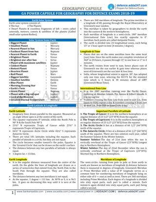
  • 1. GEOGRAPHY CAPSULE 1 www.bankersadda.com | www.sscadda.com | www.careerpower.in | ADDA247.COM | defence.adda247.com GA POWER CAPSULE FOR GEOGRAPHY FOR DEFENCE EXAMS 2018-19 Earth Solar System Earth solar system consists of : • The Sun • The Planets • Dwarf Planets & countless fragments of left – overs called asteroids, meteors, comets & satellites of the planets (Called small solar system Bodies). Solar System Some Facts • Biggest Planet : Jupiter • Smallest Planet : Mercury • Nearest Planet to Sun : Mercury • Farthest Planet from Sun : Neptune • Nearest Planet to Earth : Venus • Brightest Planet : Venus • Brightest star after Sun : Sirius • Planet with maximum satellites: Jupiter • Coldest Planet : Neptune • Hottest Planet : Venus • Heaviest Planet : Jupiter • Red Planet : Mars • Biggest Satellite : Ganymede • Smallest Satellite : Deimos • Blue Planet : Earth • Morning/Evening Star : Venus • Earth's Twin : Venus • Green Planet : Neptune • Planet with a big red spot : Jupiter • Lord of the Heavens : Jupiter • Greatest Diurnal Temperature : Mercury Earth Latitude & Longitude Earth Latitude • Imaginary lines drawn parallel to the equator. Measured as an angle whose apex is at the centre of the earth. • The equator represents 0° latitude, while the North Pole is 90° N & the South Pole 90° S • 23½° N represents Tropic of Cancer while 23½° S represents Tropic of Capricorn. • 66½° N represents Arctic Circle while 66½° S represents Antarctic Circle. • There are total 181 latitudes including the equator. Each parallel of latitude is a circle, but they are not equal. • The circle becomes smaller toward`s the poles. Equator is the ‘Greatest Circle’ that can be drawn on the earth’s surface. • The distance between any two parallels of latitude is always equal. • 1 degree lat. = 111km. Earth Longitude • It is the angular distance measured from die centre of the earth. On the globe the lines of longitude are drawn as a series of semicircles that extend from the North Pole to the South Pole through the equator. They are also called meridians. • The distance between any two meridians is not equal. • At the equator, 1 degree = 111 km. At 30°N or S, it is 96.5 km. It goes on decreasing this way until it is zero at the poles. • There are 360 meridians of longitude. The prime meridian is a longitude of 00, passing through the Royal Observatory at Greenwich near London. • This meridian is taken by geographers to divide the earth into the eastern & the western hemispheres. • Each meridian of longitude is a semi-circle. 180° meridian (International Date Line) lies exactly opposite to 0° meridian. Such points are called Antipodal Points. • The earth is divided into 24 longitudinal zones, each being 15° or 1 hour apart in time (4 minutes / degree). Longitude & Time • Places that are on the same meridian have the same local (sun) time. Since the earth makes one complete revolution of 360° in 24 hours, it passes through 15° in one hour or 1° in 4 minutes. • The earth rotates from west to east, hence places east of Greenwich see the sun earlier & gain time whereas places west of Greenwich see the sun later & lose time. • India, whose longitudinal extent is approx. 30°, has adopted only one time zone, selecting the 82.5°E for the standard time which is 5 hours & 30 minutes ahead of GMT (Greenwich Mean Time). International Date Line • It is the 180° meridian running over the Pacific Ocean, deviating at Aleutian Islands, Fiji, Samoa & Gilbert Islands. It is a zig-zag line • Travelers crossing the Date Line from west to east (i.e., from Japan to USA) repeat a day & travelers crossing it from east to west (i.e., from USA to Japan) lose a day. Important Parallels of Latitude 1. The Tropic of Cancer: It is in the northern hemisphere at an angular distance of 23 1/2° (23°30’N) from the equator. 2. The Tropic of Capricorn: It is in the southern hemisphere at an angular distance of 23 1/2° (23°30’S) from the equator. 3. The Arctic Circle: It lies at a distance of 66 1/2° (66°30’N) north of the equator. 4. The Antarctic Circle: It lies at a distance of 66 1/2° (66°30’S) south of the equator. There are two solstices each year, called the Summer Solstice & the Winter Solstice. Summer Solstice: The day of 21st June when the sun is vertically overhead at the Tropic of Cancer (23°30’N). Longest day in Northern Hemisphere. Winter Solstice: The day of 22nd December when the sun is vertically overhead at the Tropic of Capricorn (23°30’S). Shortest Day in Northern Hemisphere. Meridians of Longitude The semi-circles running from pole to pole or from north to south are known as meridians of longitude & distance between them is measured in degrees of longitude. Greenwich Meridian or Prime Meridian with a value of 0° longitude serves as a common base for numbering meridians of longitude lying on either side of it — east as well as west. There are 360 meridians including Prime Meridian. Each degree of a longitude is divided into sixty equal parts, each part is called a minute. Each minute is again divided into sixty equal parts, each part being called a second.
  • 2. GEOGRAPHY CAPSULE 2 www.bankersadda.com | www.sscadda.com | www.careerpower.in | ADDA247.COM | defence.adda247.com Local Time : Local time of any place is 12 noon when the sun is exactly overhead. It will vary from the Greenwich time at the rate of four minutes for each degree of longitude. Greenwich Mean Time : The time at 0° longitude is called Greenwich Mean Time. It is based on local time of the meridian passing through Greenwich near London. Indian Standard Time : It is fixed on the mean of 82 1/2°E Meridian, a place near Allahabad. It is 5 1/2hours ahead of Greenwich Mean Time. Facts about earth • The Earth also called Blue Planet. It is the densest of all planets. • Earth Circumference: 40,232 Kilometers. • Earth Area: 510 million Square Kilometers • Average distance from sun: 149 million Kilometers. • Earth Perihelion: Nearest position of earth to sun. The earth reaches its perihelion on January 3 every year at a distance of about 147 million-Kilometers. • Aphelion: Farthest position of earth from sun. The earth reaches its aphelion on July 4, when the earth is at a distance of 152 million Kilometers. • The shape of the earth is oblate spheroid or oblate ellipsoid (i.e. almost spherical, flattened a little at the poles with a slight bulge at the centre). Types of Earth Movements: 1. Rotation or daily movement. 2. Revolution or annual movement. Earth Rotation • Spins on its imaginary axis from west to east in 23 hrs, 56 min & 40.91 sec. • Rotational velocity at equator is 1667 Kilometers/h & it decreases towards the poles, where it is zero. Earth’s rotation results in i. Causation of days & nights; ii. A difference of one hour between two meridians which are 15° apart; iii. Change in the direction of wind & ocean currents; Rise & fall of tides everyday. iv. The longest day in North Hemisphere is June 21, while shortest day is on 22 Dec (Vice-versa in S.Hemisphere). • Days & nights are almost equal at the equator. Earth Revolution • It is earth’s motion in elliptical orbit around the sun. Earth’s average orbital velocity is 29.79 Kilometers/s. • Takes 365 days, 5 hrs, 48 min & 45.51 sec. It results in one extra day every fourth year. • Revolution of the earth results in i. Change of seasons ii. Variation in the lengths of days & nights at different times of the year iii. Shifting of wind belts iv. Determination of latitudes. Earth Eclipses Earth Lunar Eclipse  When earth comes between sun & moon.  Occurs only on a full moon day. However, it does not occur on every full moon day because the moon is so small & the plane of its orbit is tilted about 5° with respect to the plane of the earth’s orbit. It is for this reason that eclipses do not occur every month.  This light is red because the atmosphere scatters the other colors present in sunlight in greater amounts than it does red. Earth Solar Eclipse A solar eclipse is a type of eclipse that occurs when the Moon passes between the Sun & Earth, & the Moon fully or partially blocks ("occults") the Sun. This can happen only at new moon INTERIOR STRUCTURE OF THE EARTH The layering of Earth is categorized as Lithosphere, Asthenosphere, Upper mantle, Lower mantle, Outer core, & the Inner core. The earth's interior has three different layers; they are (i) the crust (ii) mantle & (iii) the core. a) Earth's Crust: All of the Earth's landforms (mountains, plains, & plateaus) are contained within it, along with the oceans, seas, lakes & rivers.  There are two different types of crust: thin oceanic crust that underlies the ocean basins & thicker continental crust that underlies the continents.  The boundary between the crust & the mantle is Mohorovicic Discontinuity. b) Earth's Mantle: It is the thick, dense rocky matter that surrounds the core with a radius of about 2885 km.  The mantle covers the majority of the Earth's volume. This is basically composed of silicate rock rich in iron & magnesium.  This layer is separated from the core by Gutenberg- Wiechert Discontinuity.  The outer & the inner mantle are separated by another discontinuity named Repetti discontinuity. c) Earth's Core: Earth's Core is thought to be composed mainly of an iron & nickel alloy.  The core is earth's source of internal heat because it contains radioactive materials which release heat as they break down into more stable substances.  The core is divided into two different zones.  The outer core is a liquid because the temperatures there are adequate to melt the iron-nickel alloy.  However, the inner core is a solid even though its temperature is higher than the outer core. Here, tremendous pressure, produced by the weight of the overlying rocks is strong enough to crowd the atoms tightly together & prevents changing it to the liquid state. EARTHQUAKES a) An earthquake is the sudden release of strain energy in the Earth's crust resulting in waves of shaking that radiate outwards from the earthquake source. b) The point at the surface directly above the focus is called the earthquake epicentre.
  • 3. GEOGRAPHY CAPSULE 3 www.bankersadda.com | www.sscadda.com | www.careerpower.in | ADDA247.COM | defence.adda247.com c) When the earth moves in an earthquake, it can cause waves in the ocean, & if a wave grows large enough, it's called a "tsunami". Underwater earthquakes sometimes produce largetical waves called Tsunami. e) Earthquakes are measured with a seismometer. The magnitude of an earthquake, & the intensity of shaking, is measured on a numerical scale. On the scale, 3 or less is scarcely noticeable, & magnitude 7 (or more) causes damage over a wide area. The point of origin of earthquake is called Seismic focus. The point on the earth’s surface vertically above the earth’s surface is called Epicentre. f) The passage of earthquake waves is recorded by Seismograph. The magnitude of waves is measured on Richter’s scale. For measurement of the intensity of the earthquake (damage caused), the Modified Mercalli Intensity Scale is used. Distribution of Earthquakes a) Around the Pacific Ocean along a belt of volcanoes known as the Ring of Fire. 68 per cent of the volcanoes are experienced in this region. b) From the middle of Asia (Himalayas, Caspian Sea) through the Mediterranean Sea to West Indies. 21 per cent earthquakes are experienced in the region. c) Mid-Atlantic ridge belt which accounts for 11 percent of the earthquakes. TYPES OF SEISMIC WAVES There are two types of seismic waves, body wave & surface waves. • Body waves travel through the interior of the Earth. They follow ray paths refracted by the varying density & stiffness of the Earth's interior which in turn, vary according to temperature, composition, & phase. Body waves are divided as P-WAVES (Primary Waves) are compression waves that are longitudinal in nature. These waves can travel through any type of material, & can travel at nearly twice the speed of S waves. S-WAVES (Secondary Waves) are shear waves that are transverse in nature. These waves typically follow P waves during an earthquake & displace the ground perpendicular to the direction of propagation. S waves can travel only through solids, as fluids (liquids & gases) do not support shear stresses. S waves are slower than P waves, & speeds are typically around 60% of that of P waves in any given material. • Surface waves are analogous to water waves & travel along the Earth's surface. They travel slower than body waves. There are two types of surface waves: Rayleigh waves, also called ground roll, are surface waves that travel as ripples with motions that are similar to those of waves on the surface of water. Love waves are surface waves that cause circular shearing of the ground. They are named after A.E.H. Love, a British mathematician who created a mathematical model of the waves in 1911. They usually travel slightly faster than Rayleigh waves, about 90% of the S wave velocity, & have the largest amplitude. The asthenosphere separates the strong, solid rock of the uppermost mantle & crust above from the remainder of the strong, solid mantle below. The combination of uppermost mantle & crust above the asthenosphere is called the lithosphere. The lithosphere is free to move (glide) over the weak asthenosphere. The tectonic plates are, in fact, lithospheric plates. VOLCANOES A volcano is generally a conical shaped hill or mountain built by accumulations of lava flows, & volcanic ash.  About 95% of active volcanoes occur at the plate subduction zones & at the mid-oceanic ridges.  Subduction is the process that takes place at convergent boundaries by which one tectonic plate moves under another tectonic plate & sinks into the mantle as the plates converge. Regions where this process occurs are known as sub-duction zones.  The other 5% occur in areas associated with lithospheric hot spots. It is believed that hot spots are caused by plumes of rising magma that have their origin within the asthenosphere. Types of Volcanoes Geologists have classified five different types of volcanoes. This classification is based on the geomorphic form, magma chemistry, & the explosiveness of the eruption. Shield Volcano- Slightly sloping volcanoes, 6 to 12°, that have gently flowing magmas called shield volcanoes Shield volcanoes can be up to 9000 meters tall. The volcanoes of the Hawaiian Islands are typical of this type. Cinder Cone volcano is a small volcano, between 100 & 400 meters tall, made up of exploded rock blasted out of a central vent at a high velocity. These volcanoes develop from magma of basaltic to intermediate composition. They form when large amounts of gas accumulate within rising magma. Examples of cinder cones include Little Lake Volcano in California & Paricuti Volcano in Mexico. Composite volcanoes are made from alternate layers of lava flows & exploded rock. Their height ranges from 100 to 3500 meters tall. The chemistry of the magma of these volcanoes is quite variable ranging from basalt to granite. Classification on the basis of Periodicity of Eruptions  Active Volcano: Volcanoes which erupt periodically. E.g. Maona Loa in Hawaii, Etna in Sicily, Vesuvius in Italy, Stromboli in Mediterranean Sea, etc.  Dormant Volcano: Volcanoes which has been quiet for a long time but in which there is a possibility of eruption. E.g. Fujiyama in Japan, Krakatoa in Indonesia, Barren island Volcano in Andamans, etc.  Extinct Volcano: An extinct volcano has not had an eruption for at least 10,000 years and is not expected to erupt again in a comparable time scale of the future. Distribution of Volcanoes in the World About 15% of world’s active volcanoes are found along the ‘constructive or divergent’ plate margins, whereas 80% volcanoes are associated with the ‘destructive or convergent’ plate boundaries. Earth Mountains Types of Mountains  Fold Mountains: They are formed when the rocks of the crust of the earth folded under stress, mainly by forces of compression (as a result of series of earthquakes). E.g. – All
  • 4. GEOGRAPHY CAPSULE 4 www.bankersadda.com | www.sscadda.com | www.careerpower.in | ADDA247.COM | defence.adda247.com big Mountain Systems: Himalayas, Alps, Andes, Rockies, Atlas, etc.  Block Mountains: When large areas are broken and displaced vertically, Block Mountains are formed. In this case, the uplifted blocks are called horsts. On the other hand, the lowered blocks are called graben.  Relict Mountains: Sometimes, the mountains are carved out as a result of erosion of plateaus & high planes by various agents of erosion. E.g., Highlands of Scotland, Sierras of Spain, Catskill mountains of New York & Nilgiri, Parasnath, Girnar, Rajmahal of India.  Volcanic Mountain: A mountain formed due to volcanic activity is called Volcanic Mountain. Examples of Volcanic Mountains are; Mt. Kilimanjaro and Mt. Fujiyama. ROCKS & MINERALS About 98 per cent of the total crust of the earth is composed of eight elements like oxygen, silicon, aluminium, iron, calcium, sodium, potassium & magnesium & the rest is constituted by titanium, hydrogen, phosphorous, manganese, sulphur, carbon, nickel & other. 1) The three types of rocks are i)Igneous Rocks 1) Igneous rocks solidify from a liquid magma as it cools. When magma cools rapidly, mineral crystals do not have time to grow very large. On the other hand when magma cools slowly crystals grow to several millimeters or more in size. Granite & basalt are the examples of IR. Igneous rocks are classified as a) Extrusive Rocks Extrusive igneous rocks solidify from molten material that flows over the earth’s surface (lava). Common extrusive rocks are i) basalt, ii) andesite, & iii) rhyolite. b) Intrusive Rocks Intrusive rocks form from molten material (magma) that flows & solidifies underground. Common rock types within the intrusive category are granite & diorite. ii. Sedimentary Rocks These are types of rocks created from deposition of layers upon layers of sediments over time. These types of rocks are formed on the Earth's surface, as well as underwater. Examples – Sandstone, limestone, stromatolites , oil shale & coal shale, gypsum, shale, & conglomerate. iii. Metamorphic Rocks Metamorphic rocks are any rock type that has been altered by heat, pressure, and/or the chemical action of fluids & gases. When igneous rocks, or sedimentary rocks, or even metamorphic rocks get buried very deep under the earth's surface, a process that takes millions of years, they get changed into something else by the enormous pressure & heat inside the earth. Some examples of metamorphic rocks are: • Limestone being changed into marble • Shale turning into slate • Granite being changed into gneiss • Sandstone turning into quartzite ATMOSPHERE Atmosphere is a thick gaseous envelope that surrounds the earth & extends thousands of kilometers above the earth's surface. Much of the life on the earth exists because of the atmosphere otherwise the earth would have been barren. Nitrogen & Oxygen comprise 99% of the total volume of the atmosphere. Structure of the Atmosphere The atmosphere consists of almost concentric layers of air with varying density & temperature. a) Troposphere: • Lowest layer of the atmosphere. • The height of troposphere is 16 km thick over the equator & 10 km thick at the poles. • All weather phenomena are confined to troposphere (e.g. fog, cloud, frost, rainfall, storms, etc.) • Temperature decreases with height in this layer roughly at the rate of 6.5° per 1000 metres, which is called normal lapse rate. • Upper limit of the troposphere is called tropopause which is about 1.5 km. • b) Stratosphere: • The stratosphere is more or less devoid of major weather phenomenon but there is circulation of feeble winds & cirrus cloud in the lower stratosphere. • Jet aircrafts fly through the lower stratosphere because it provides perfect flying conditions. • Ozone layer lies within the stratosphere mostly at the altitude of 15 to 35 km above earth's surface. • Ozone layer acts as a protective cover as it absorbs ultra- voilet rays of solar radiation. • Depletion of ozone may result in rise of temperature of ground surface & lower atmosphere. • Temperature rises from -60°C at the base of the stratosphere to its upper boundary as it absorbs ultra- voilet rays. • Upper limit of the Stratosphere is called stratopause. c) Mesosphere • Mesosphere extends to the height of 50-90 km. • Temperature decreases with height. It reaches a minimum of -80°C at an altitude of 80-90 km • The upper limit is called mesopause. d) Thermosphere • It lies at 80 km to 640 km above the earth's surface. • It is also known as ionosphere. • Temperature increases rapidly with increasing height. • It is an electrically charged layer. This layer is produced due to interaction of solar radiation & the chemicals present, thus disappears with the sunset. • There are a number of layers in thermosphere e.g. D-layer, E-layer, F-layer & G-layer. • Radio waves transmitted from earth are reflected back to the earth by these layers. e) Exosphere • This is the uppermost layer of the atmosphere extending beyond the ionosphere. • The density is very low & temperature becomes 5568°C. • This layer merges with the outer space.
  • 5. GEOGRAPHY CAPSULE 5 www.bankersadda.com | www.sscadda.com | www.careerpower.in | ADDA247.COM | defence.adda247.com About Ionosphere At heights of 80 km (50 miles), the gas is so thin that free electrons can exist for short periods of time before they are captured by a nearby positive ion. This portion of the atmosphere is ionized & contains plasma which is referred to as the ionosphere. The Ultraviolet (UV), X-Ray & shorter wavelengths of solar radiation ionizes the atmosphere. The ionosphere is broken down into the D, E & F regions. PRESSURE & WIND BELTS Air pressure is thus defined as total weight of a mass of column of air above per unit area at sea level. The amount of pressure exerted by air at a particular point is determined by temperature & density which is measured as a force per unit area. • Aneroid Barometer-It is the most common type barometer used in homes. Pressure Belts of the World a) Equatorial Low Pressure Belt:  At the Equator heated air rises leaving a low-pressure area at the surface. This low pressure area is known as equatorial low pressure.  The zone shifts along with the northward or southward movement of sun during summer solstice & winter solstice respectively.  The pressure belt is thermally induced because the ground surface gets heated during the day. Thus warm air expands, rises up & creates low pressure. They are also called Doldrums.  Extend 5° N & S to the equator. b) Sub-tropical High Pressure Belt:  The warm air risen up at the equator due to heating reaches the troposphere & bend towards the pole.  Due to coriollis force the air descends at 30-35º N & S latitude thus creates the belt of sub-tropical high pressure.  The pressure belt is dynamically induced as it owes its origin to the rotation of the earth & sinking & settling of winds. This zone is characterized by anticyclonic conditions which cause atmospheric stability & aridity. Called as Horse latitudes c) Sub-Polar Low Pressure Belt:  This belt is located between 60-65 degrees N & S latitudes in both the hemisphere.  This pressure belt is also dynamically induced. The belt is more developed & regular in the southern hemisphere than the northern due to over dominance of water in the former. d) Polar High Pressure Belt: High pressure persists at the pole due to low temperature. Thus the Polar High Pressure Belt is thermally induced as well as dynamically induced as the rotation of earth also plays a minor role. Coriolis Force The rotation of the Earth creates force, termed Coriolis force, which acts upon wind. Instead of wind blowing directly from high to low pressure, the rotation of the Earth causes wind to be deflected off course.  In the Northern Hemisphere, wind is deflected to the right of its path, while in the Southern Hemisphere it is deflected to the left.  Coriolis force is absent at the equator, & its strength increases as one approaches either pole. Furthermore, an increase in wind speed also results in a stronger Coriolis force, & thus in greater deflection of the wind. Winds  When the movement of the air in the atmosphere is in a horizontal direction over the surface of the earth, it is known as the wind.  Movement of the wind is directly controlled by pressure.  Horizontally, at the Earth's surface wind always blows from areas of high pressure to areas of low pressure usually at speeds determined by the rate of air pressure change between pressure centres. I. Planetary winds: Planetary winds are major component of the general global circulation of air. These are known as planetary winds because of their prevalence in the global scale throughout the year. Planetary winds occur due to temperature & pressure variance throughout the world. The planetary winds are discussed below: (a) Trade wind Winds blowing from the Subtropical High Pressure Belt or horse latitudes towards the Equatorial Low Pressure Belt or the ITCZ are the trade winds.  In the Northern Hemisphere, the trade winds blow from the northeast & are known as the Northeast Trade Winds  In the Southern Hemisphere, the winds blow from the southeast & are called the Southeast Trade Winds. (b) Westerly Wind The Westerlies are the prevailing winds in the middle latitudes between 35º & 65º latitude, blowing from the high pressure area in the Sub Tropical High Pressure Belt i.e. horse latitudes towards the sub polar low pressure belt.  The winds are predominantly from the south-west to north- east in the Northern Hemisphere & from the north-west to south-east in the Southern Hemisphere.  The Westerlies are strongest in the winter season & times when the pressure is lower over the poles, while they are weakest in the summer season & when pressures are higher over the poles.
  • 6. GEOGRAPHY CAPSULE 6 www.bankersadda.com | www.sscadda.com | www.careerpower.in | ADDA247.COM | defence.adda247.com  The Westerlies are particularly strong, especially in the Southern Hemisphere, as there is less land in the middle latitudes to obstruct the flow. (c) Polar Wind The winds blowing in the Arctic & the Antarctic latitudes are known as the Polar Winds.  They have been termed the 'Polar Easterlies', as they blow from the Polar High Pressure belt towards the Sub-Polar Low-Pressure Belts.  In the Northern Hemisphere, they blow in general from the north-east, & are called the North-East Polar Winds; & in the Southern Hemisphere, they blow from the south-east & are called the South- East Polar Winds.  As these winds blow from the ice-capped landmass, they are extremely cold. They are more regular in the Southern Hemisphere than in the Northern Hemisphere. II. Periodic Winds: They change their direction periodically with change in season.  Land & sea breezes & monsoon winds are winds of a periodic type.  Land & sea breezes occur daily, whereas the occurrence of monsoon winds is seasonal.  Following are periodic winds: (a) Monsoon winds (b) Land & Sea Breeze (c) Mountain & Valley Breeze (a) Monsoon Winds Monsoons are regional scale wind systems that periodically change direction with the passing of the seasons. Like land & sea breezes, these wind systems are created by the temperature contrasts that exist between the surfaces of land & ocean. (b) Land & Sea Breezes:  A land breeze is created when the land is cooler than the water such as at night & the surface winds have to be very light. When this happens the air over the water slowly begins to rise, as the air begins to rise, the air over the surface of the ocean has to be replaced, this is done by drawing the air from the land over the water, thus creating a sea breeze.  A sea breeze is created when the surface of the land is heated sufficiently to start rising of the air. As air rises, it is replaced by air from the sea; created a sea breeze. Sea breezes tend to be much stronger & can produce gusty winds as the sun can heat the land to very warm temperatures, thereby creating a significant temperature contrast to the water. (c) Mountain & Valley winds: Mountain-valley breezes are formed by the daily difference of the thermo effects between peaks & valleys. In daytime, the mountainside is directly heated by the sun, the temperature is higher, air expands, air pressure reduces, & therefore air will rise up the mountainside from the valley & generate a valley breeze. Anabatic & Katabatic winds: Katabatic is a local wind caused (often at night) by the flow of air, cooled by radiation, down mountain slopes and valleys. Anabatic is an upslope wind formed when air on hill sides is heated by insolation conduction to a greater extent than air at the same horizontallevel but vertically above the valley floor. III. Local Winds These local winds blow in the various region of the world. Hot Winds Sirocco - Sahara Desert Leveche - Spain Khamsin - Egypt Harmattan - Sahara Desert Santa Ana - USA Zonda - Argentina Brick fielder – Australia Loo – India Cold Winds Mistral - Spain & France Bora - Adriatic coast Pampero - Argentina Buran - Siberia JET-STREAMS The JET STREAMS located in the upper troposphere (9 - 14 km) are bands of high speed winds (95-190 km/hr). The term was introduced in 1947 by Carl Gustaf Rossby. Average speed is very high with a lower limit of about 120 Kms in winter & 50 km per hours in summer. The two most important types of jet streams are the Polar Jet Streams & the Subtropical Jet Streams. EL NINO & LA NINA – El Nino and La Nina events are a natural part of the global climate system. El Nino events are associated with a warming of the central and eastern tropical Pacific, while La Nina events are the reverse, with a sustained cooling of these same areas. CYCLONES Cyclones are well developed low-pressure systems surrounded by closed isobars having increasing pressure outside & closed air circulation towards the centre such that the air blows inward in anticlockwise direction in the northern hemisphere & clockwise in the southern hemisphere. A. Tropical cyclones Tropical cyclones are intense cyclonic storms that develop over the warm oceans of the tropics. Surface atmospheric pressure in the centre of tropical cyclones tends to be extremely low. The main characteristics of tropical cyclones are:- • Have winds that exceed 34 knots (39 miles/hr) • Blow clockwise in the Southern Hemisphere and • Counter-clockwise about their centres in the Northern Hemisphere This is one of the most devastating natural calamities. They are known as Cyclones in the Indian Ocean Hurricanes in the Atlantic Typhoons in the Western Pacific & South China Sea Willy-Willies in the Western Australia.
  • 7. GEOGRAPHY CAPSULE 7 www.bankersadda.com | www.sscadda.com | www.careerpower.in | ADDA247.COM | defence.adda247.com B. Temperate cyclones The systems developing in the mid & high latitude, beyond the tropics are called the middle latitude or temperate cyclones. Extra tropical cyclones form along the polar front. Two air masses of contrasting physical properties: One air mass is polar in character & is cold, denser & north- easterly in direction while the other air mass is tropical in origin & is warm, moist, lighter & south westerly in direction. An anticyclone is a region of high atmospheric pressure related to the surrounding air, generally thousands of kilometres in diameter & also known as a high or high-pressure system. Winds in an anticyclone form a clockwise out-spiral in the Northern Hemisphere; whereas they form an anti-clockwise out-spiral in the Southern Hemisphere. OCEANOGRAPHY The study of sea floor by echo method of sound waves reveals that the sea floor is not a flat area. It consists of mountains, plateaus, plains & trenches etc. Some major submarine features are described below. a) Continental Shelf 1) The portion of the land which is submerged under sea water is continental shelf. 2) The continental shelf is shallow & its depth is not more than 200 metres. 3) In all about 7.5 percent of total area of the oceans is covered by the continental shelves. The shelves are of great use to man because: 1. Marine food comes almost entirely from them. 2. About 20 percent of oil & gas of the world is extracted from them. 3. They are the sites of productive fishing grounds. b) Continental Slope It is an area of steep slope extending just after the continental shelf up to a considerable depth from where a gentle sea plain takes its form. The extent of the slope area is usually between 200-2000 m. But sometimes it may extend to 3660 metres from the mean sea level. The continental slope along many coasts of the world is followed by deep canyon like trenches terminating as fan shaped deposits at the base. Continental slope covers 8.5 percent of the total ocean area. c) Continental Rise 1) The gently sloping surface at the base of the continental slope is called continental rise. 2) It may extend to hundreds of km into the deep ocean basin. d) Deep Ocean Basins It is the portion of sea floor that lies between the continental margin & the oceanic ridge system. It contains deep-ocean trenches, abyssal plains, & broad volcanic peaks called seamounts. I. Deep-Ocean Trenches: a) These are long, narrow features that form the deepest parts of the ocean. b) Most trenches are located in the Pacific Ocean. c) They may reach 10,000 m deep d) Mariana trench is about 11,000 m below sea level in PO. II. Abyssal Plains: These are the most level places on Earth. The abyssal plains may have less than 3 m of relief over a distance that may exceed 1300 km. Scientists determined that abyssal plains low relief is due to the fact that thick accumulations of sediment, transported by turbidity currents, have buried rugged ocean floor. III. Seamounts: It is an isolated volcanic peak that rises at least 1000 m (3300 ft) above the deep-ocean floor. They are more extensive in the Pacific Ocean, where subduction zones are common. These undersea volcanoes form near oceanic ridges (regions of seafloor spreading). Some of these volcanoes may emerge as an island. e) Submarine Canyons These are depressions with walls of steep slopes & have a V shape. They exist on the continental slopes & the shelves. They are found to have a length of 16 km at the maximum. OCEAN CURRENTS Ocean currents are large masses of surface water that circulate in regular patterns around the oceans. Those that flow from equatorial regions polewards have a higher surface temperature & are warm currents. Those that flow from polar regions equatorwards have a lower surface temperature & are cold currents. Factors lead to OCEAN CURRENT 1. The planetary winds. 2. Temperatures. 3. Salinity. 4. The earth’s rotation. 5. Land. THE CIRCULATION (THE ATLANTIC OCEAN)  At the ‘shoulder’ of north-east Brazil, the protruding lands mass splits the South Equatorial Current into the Cayenne Current which flows along the Guiana coast, & the Brazilian Current which flows southwards along the east coast of Brazil.  Part of the current enters the Gulf of Mexico & emerges from the Florida Strait between Florida & Cuba as the Florida Current.  The rest of the equatorial water flows northwards east of the Antilles to join the Gulf Stream off the south-eastern U.S.A.  The Gulf Stream Drift is one of the strongest ocean currents & hugs the coast of America as far as Cape Hatteras (latitude 350N), where it is deflected eastwards under the combined influence of the Westerlies & the rotation of the earth. It reaches Europe as the North Atlantic Drift.  The cold Labrador Current drift southeastwards between West Greenland & Baffin Island to meet the warm Gulf Stream off Newfoundland.  On reaching the west coast of Africa the current is diverted northwards as the cold Benguela Current (the counterpart of the Canaries Current).
  • 8. GEOGRAPHY CAPSULE 8 www.bankersadda.com | www.sscadda.com | www.careerpower.in | ADDA247.COM | defence.adda247.com THE CIRUCLATION (PACIFIC OCEAN)  The North- East Trade Winds blow the North Equatorial Current off the coasts of the Philippines & Formosa into the East China Sea as the Kuroshio or Japan current.  The cold Bering Current or Alaskan Current creeps southwards from the narrow Bering Strait & is joined by Okhotsk Current to meet the warm Japan Current as the Oyashio, off Hokkaido.  The South Equatorial Current, driven by the South-East Trade winds, flows southwards along the coast of Queensland as the East Australian Current. Obstructed by the tip of southern Chile, the current turns northwards along the western coast of South America as the cold Humboldt or Peruvian Current. THE INDIAN OCEAN CIRCULATION  The currents of South Indian Ocean form a circuit.  The Equatorial Current, turning southwards past Madagascar as the Agulhas or Mozambique Current merges with the West Wind Drift, flowing eastwards & turns equator-wards as the West Australian Current.  In the North Indian Ocean, there is a complete reversal of the direction of currents between summer & winter, due to the changes of monsoon winds.  In summer from June to October, when the dominant wind is the South-West Monsoon, the currents are blown from a south-westerly direction as the South- West Monsoon Drift. This is reversed in winter; Monsoon blows the currents from the north-east as the North-East Monsoon Drift. The currents of the North Indian Ocean, demonstrate most convincingly the dominant effects of winds on the circulation of ocean currents. OCEANS Arctic Ocean-- The Arctic Ocean is the smallest of the world's five oceans. The Northwest Passage (US & Canada) & Northern Sea Route (Norway & Russia) are two important seasonal waterways. It is a body of water between Europe, Asia, & North America, mostly north of the Arctic Circle. Lowest point: Fram Basin (Now known as Nansen Basin) Atlantic Ocean-- The Atlantic Ocean is the second largest of the world's five oceans. The Kiel Canal (Germany), Oresund (Denmark-Sweden), Bosporus (Turkey), Strait of Gibraltar (Morocco-Spain), & the Saint Lawrence Seaway (Canada-US) are important strategic access waterways. It is a body of water between Africa, Europe, the Southern Ocean, & the Western Hemisphere. It includes includes Baltic Sea, Black Sea, Caribbean Sea, part of the Drake Passage, Gulf of Mexico, Mediterranean Sea, & other tributary water bodies.Panama Canal connects the Atlantic and Pacific oceans Lowest point: Milwaukee Deep in the Puerto Rico Trench Indian Ocean- The Indian Ocean is the third largest of the world's five oceans. Four critically important access waterways are the Suez Canal (Egypt), Bab-el Mandeb (Djibouti-Yemen), Strait of Hormuz (Iran-Oman), & Strait of Malacca (Indonesia- Malaysia). It is a body of water between Africa, the Southern Ocean, Asia, & Australia. It includes Andaman Sea, Arabian Sea, Bay of Bengal, Flores Sea, Gulf of Aden, Gulf of Oman, Java Sea, Red Sea, Strait of Malacca, Timor Sea, & other tributary water bodies. Lowest point: Java Trench Pacific Ocean The Pacific Ocean is the largest of the world's five oceans. Strategically important access waterways include the La Perouse, Tsugaru, Tsushima, Taiwan, Singapore, & Torres Straits. It is body of water between the Southern Ocean, Asia, Australia, & the Western Hemisphere. It includes Bali Sea, Bering Sea, Coral Sea, East China Sea, Gulf of Alaska, Philippine Sea, Sea of Japan, Sea of Okhotsk, Tasman Sea, & other tributary water bodies. Lowest point: Challenger Deep in the Mariana Trench. Southern Ocean -The Southern Ocean, also known as the Antarctic Ocean or the Austral Ocean, comprises the southernmost waters of the World Ocean, generally taken to be south of 60° S latitude and encircling Antarctica. TIDES The tide is the periodic rise & fall of the sea levels caused by the combined effects of the gravitational forces exerted by the Moon & Sun & rotation of the earth.  Most places in the ocean usually experience two high tides & two low tides each day (semidiurnal tide), but some locations experience only one high & one low tide each day (diurnal tide).  The times & amplitude of the tides at the coast are influenced by the alignment of the Sun & Moon, by the depth of the ocean, & by the shape of the coastline & near- shore bathymetry. When the moon exerts gravitational force on the earth the tidal bulge moves out & causes high tide. Simultaneously on the side opposite to that place on the earth i.e. just at 180° to it, also experiences the tidal bulge due to reactionary force (centrifugal) of the gravitational (centripetal) force. Thus two tides are experienced twice at every place on the earth's water surface within 24 hours. Due to the cyclic rotation of the earth & moon, the tidal cycle is 24 hours & 52 minutes long. Causes of Tides • Gravitational attraction between moon & the earth. • Gravitational attraction between sun & the earth. • Attraction force of the earth towards earth centre. • Moon is mainly responsible for the tides. Types of Tides • Semi diurnal tides - Recur at the intervals of 12½ hours. • Diurnal Tides - Recur at the intervals of 24½ hours. • Spring Tides - once a fortnight, due to the revolution of the moon & its declination. • Neap tides - Once a fortnight due to the revolution & declination of moon. • Monthly tides - Due to the revolution of the moon & its position at Perigee & Apogee.
  • 9. GEOGRAPHY CAPSULE 9 www.bankersadda.com | www.sscadda.com | www.careerpower.in | ADDA247.COM | defence.adda247.com SPRING TIDES Spring tides are especially strong tides or high tides. They occur when the Earth, the Sun, & the Moon are in a line. The gravitational forces of the Moon & the Sun both contribute to the tides. Spring tides occur during the full moon & the new moon. NEAP TIDES Neap tides are especially weak tides. They occur when the gravitational forces of the Moon & the Sun are perpendicular to one another (with respect to the Earth). Neap tides occur during quarter moons. The Bay of Fundy between Nova Scotia & New Brunswick in Canada experiences the world's greatest tidal range of 50 feet (15.25 meters) MOUNTAINS OF INDIA The Himalayas Means ‘Abode of Snow’. They are one of the youngest fold mountain ranges in the world & comprise mainly sedimentary rocks.  They stretch from the Indus River in the west to the Brahmaputra River in the east.  The Eastern Himalayas-made up of Patkai Hills, Naga Hills, Mizo Hills & the Garo, Khasi & Jaintia Hills-are also known as Purvanchal.  The Pamir, popularly known as the Roof of the World, is the connecting link between the Himalayas & the high ranges of Central Asia. Can be divided into 3 parallel or longitudinal zones, each with separate features. THE GREAT HIMALAYAS OR THE HIMADRI  There are few passes & almost all of them have a height above 4,500 m.  They include Shipki La & Bara Lapcha La in Himachal Pradesh, Burzil & Zozi La in Kashmir, Niti, Lipulekh & Thang La in Uttarankhand, & Jelep La & Nathu La in Sikkim.  Average elevation extends upto 6000m Some of the world’s highest peaks are: Mt Everest (or Sagarmatha or Chomo Langma) 8848 m (in Nepal) Mt Kanchenjunqa 8598 m (in India) Mt Makalu 8481 m (in Nepal) Mt Dhaulaqiri 81 72 m (in Nepal) Mt Cho Oyu 8153m (in Nepal) Mt Nanga Parbat 8126m (in India) Mt Annapurna 8078 m (in Nepal) Mt Nando Devi 7817 m (in India) LESSER HIMALAYAS OR THE HIMACHAL  Average height of mountains is 3700 – 4500 m.  Mountains & valleys are disposed in all direction (mountains rising to 5000 m & the valleys touching 1000 m). Its important ranges are: Dhauladhar, Pir Panjal, Nag Tibba, Mussoorie. Outer Himalayas or The Shiwaliks  Lowest range (average elevation is 900-1200 m).  Forms the foothills & lies between the Lesser Himalayas & the plains. It is the newest range. TRANS – HIMALAYAN ZONE This range lies to the north of the Great Himalayas.  It has some important ranges like Karakoram, Ladakh, Zanskar, etc.  The highest peak in this region is K2 or Godwin Austin (8611m, in Pak occupied Kashmir). Other high peaks are Hidden Peak (8068 m), Broad Peak (8047 m) & Gasherbrum II (8035 m).  The longest glacier is Siachin in the Nubra valley, which is more than 72 km long (biggest glacier in the world). Biafo, Baltaro, Batura, Hispar are the other important glaciers in this region. This area is the largest snow-field outside the Polar Regions. IMPORTANT FACTS ⇒ Uttar Pradesh borders the maximum number of States-8 (Uttarakhand, HP, Haryana, Rajasthan, MP, Chhattisgarh, Jharkhand,Bihar). ⇒ After UP is Assam, which touches the border of 7 States. ⇒ Tropic of Cancer passes through 8 States: Gujarat, Rajasthan, Madhya Pradesh, Chhattisgarh, Jharkhand, West Bengal, Tripura, Mizoram. ⇒ Indian Standard Meridian passes through 5 States: UP, MP, Chhattisgarh, Orissa, Andhra Pradesh. ⇒ 10 States form the coast of India. They are: Gujarat, Maharashtra, Goa, Karnataka, Kerala, Tamil Nadu, Andhra Pradesh, Telangana, Odisha & West Bengal. ⇒ 2 Union Territories, viz. Daman & Diu & Pondicherry are also on the coast. ⇒ The Union Territories of Andaman & Nicobar Islands & Lakshadweep are made up of islands only. THE PLAINS OF INDIA To the south of the Himalayas & to the north of the Peninsula lies the great plains of North India. They are formed by the depositional works of three major river systems, Indus, Ganga & Brahmaputra. The vast plains of north India are alluvial in nature & the westernmost portion is occupied by the Thar Desert. The thickness of the alluvium is maximum in the Ganga plains & minimum in the Western Plains. The plains consist of four divisions: Physiographic Bhabar : Along the foothills of Shiwaliks. Highly porous – (Smaller Streams disappear) Tarai : Re-emergence of streams. Zone of excessive dampness – South of Bhabar Bhangar : Older alluvial plains, contain calcareous formations called ‘kankar’ Khadar : New alluvium & forms the flood plains along the river banks. Delta : A river delta is a landform that forms from deposition of sediment carried by a river as the flow leaves its mouth and enters slower-moving or stagnant water. PENINSULAR PLATEAU OF INDIA Spreads south of the Indo-Gangetic plains flanked by sea on three sides. This plateau is shaped like a triangle with its base in the north. The Eastern Ghats & the Western Ghats constitute its eastern & western boundaries, respectively.
  • 10. GEOGRAPHY CAPSULE 10 www.bankersadda.com | www.sscadda.com | www.careerpower.in | ADDA247.COM | defence.adda247.com ⇒ Narmada, which flows through a rift valley, divides the region into two parts: The Malwa Plateau in the north & the Deccan Plateau in the south. ⇒ Vindhya Plateau is situated south of Malwa plateau. ⇒ Chhota Nagpur Plateau lies to the west of Bengal basin, the largest & most typical part of which is the Ranchi plateau. ⇒ The Deccan Plateau is the largest plateau in India. It is made up of lava flows in the Cretaceous-Eocene era through the fissure eruptions. ISLANDS OF INDIA Total coastline of India: 7516 km. Longest coastline: Gujarat (Second longest is of Andhra Pradesh). Indian territorial limits include 248 islands: The Andaman & Nicobar Group Andamans is a group of 204 islands of which the largest is Middle Andaman. The Andamans are believed to be extensions of mountains system in the N.E. part of the country. Saddle Peak (737 m) in N.Andaman is the highest peak. The Nicobars is a group of 19 islands of which the largest is Great Nicobar. Most of them are volcanic in nature. Great Nicobar is the southernmost island & is only 147 km away from Sumatra island of Indonesia. Volcanic Islands: Barren & Narcodam Islands. Barren is in the process of eruption these days after lying dormant for 200 years. The Arabian Sea Group All the islands in the Arabian Sea (Total 25) are coral islands & are surrounded by Fringing Reefs (North : Lakshadweep, South: Minicoy). DO YOU KNOW? Ten Degree Channel separates Andamans from Nicobars (Little Andaman from Car Nicobar) Duncan Passage lies between South Andaman & Little Andaman. Nine Degree Channel separates Kavaratti from Minicoy Island. Eight Degree Channel separates Minicoy Island (India) from Maldives. RIVERS OF INDIA In India, the rivers can be divided into two main groups: Himalayan Rivers--1) Indus 2) Ganga 3) Bhramputra Peninsular Rivers--1) East flowing 2) West flowing HIMALAYAN RIVERS OF INDIA THE INDUS SYSTEM It has a total length of 2880 km (709 km in India). Rises in Tibet (China) near Mansarovar Lake. In Jammu & Kashmir, its Himalayan tributaries are: Zanskar, Dras, Gartang, Shyok, Shigar, Nubra, Gilgit, etc. Its most important tributaries, which join Indus at various places, are: Jhelum, Chenab (1800 km), Ravi, Beas & Satluj. Sources: Jhelum from Verinag (SE Kashmir), Ravi from Kullu Hills near Rohtang Pass in Himachal Pradesh, Beas from a place near Rohtang Pass in Himachal Pradesh & Satluj from Mansarovar – Rakas lakes in W. Tibet, Chenab-near Bara Lacha Pass, Hemachal Pradesh THE GANGA SYSTEM It is 2525 km long of which 1450 km is in Uttarakhand & UP, 445 km in Bihar & 520 km in West Bengal. The Ganga, the head stream is constituted of two main rivers – Bhagirthi & Alaknanda, which combine at Devprayag to form Ganga. Sources: Bhagirthi from Gaumukh, Alaknanda from Badrinath, Mandakini from Kedarnath (all from Uttarakhand). Yamuna (1375 km) is its most important tributary (on right bank). It rises at the Yamunotri glacier in Uttarakhand. It runs parallel to Ganga for 800km & joins it at Allahabad. Important tributaries of Yamuna are Chambal, Betwa (480 km) & Ken (all from south). Apart from Yamuna, other tributaries of Ganga are Ghaghra (1080 km), Son (780 km), Gandak (425 km), Kosi (730 km), Gomti (805 km), Damodar (541 km). Kosi is infamous as ‘Sorrow of Bihar’, while Damodar gets the name ‘Sorrow of Bengal’ as these cause floods in these regions. Hooghli is a distributory of Ganga flowing through Kolkata. THE BRAHMAPUTRA SYSTEM It has a total length of 2900 km. It rises in Tibet (from Chemayungdung glacier), where it is called Tsangpo, & enters the Indian territory (in Arunachal Pradesh) under the name Dihang. Important Tributaries: Subansiri, Kameng, Dhansiri, Manas, Teesta. In Bangladesh, Brahmaputra is known by the name of Jamuna while Ganga gets the name Padma. Their combined stream is known as Padma only. Meghna is the most important distributory before it enters the Bay of Bengal. The combined stream of Ganga & Brahmaputra forms the biggest delta in the world, the Sundarbans, covering an area of 58,752 sq. km. Its major part is in Bangladesh. On Brahmaputra is the river island, Majuli on Brahamaputra in Assam, is the biggest river island in the world. Brahmaputra, or the Red River, is navigable for a distance of 1384 km up to Dibrugarh & serves as an excellent inland water transport route. RIVERS OF THE PENINSULA IN INDIA A. EAST FLOWING RIVERS OF INDIA (OR DELTA FORMING RIVERS) Mahanadi River (858 km) : Rises in Raipur distt. in Chhatisgarh. Godavari River (1465 km) : Also called Vriddha Ganga or Dakshina Ganga. It is the longest peninsular river. Rises in Nasik. Main tributaries: Manjra, Penganga, Wardha, Indravati, Wainganga, etc. Krishna River (1327 km): Rises in Western Ghats near Mahabaleshwar. Main tributaries: Koyna, Dudhganga, Panchganga, Malprabha, Bhima, Tungabhadra, etc. Cauvery River (805 km): It is the largest peninsular river (maximum amount of water). Infact, it is the only peninsular river which flows almost throughout the year. Known as the ‘Ganga of the South’. It rises from the Brahmagir range of Western Ghats. Main tributaries: Hemavati, Lokpawni, Shimsa.
  • 11. GEOGRAPHY CAPSULE 11 www.bankersadda.com | www.sscadda.com | www.careerpower.in | ADDA247.COM | defence.adda247.com Swarnarekha River (395 km) & Brahmani (705 km) : Rises from Ranchi Plateau. B. WEST FLOWING RIVERS IN INDIA Narmada River (1312 km) : Rises in Amarkantak Plateau & flows into Gulf of Khambat. It forms the famous Dhuan Dhar Falls near Jabalpur. Main tributaries: Hiran, Burhner, Banjar, Shar, Shakkar, Tawa, etc. Tapti River (724 km) : Rises from Betul distt in Maharashtra. Also known as twin or handmaid of Narmada. Main tributaries: Purna, Betul, Arunavati, Ganjal, etc. Sabarmati River (416 km) : Rises from Aravallis in Rajasthan. Mahi River (560 km) : Rises from Vindhyas in Maharashtra. Luni River (450 km) : Rises from Aravallis. Also called Salt River. It is finally lost in the marshy grounds at the head of the Rann of Kuchchh. Sharavati is a west flowing river of the Sahyadris. It forms the famous Jog or Gersoppa or Mahatma Gandhi Falls (289 m), which is the one of the highest waterfall in India. Note: ⇒ (The largest man-made lake in India is Indira Sagar Lake, which is the reservoir on Indira Sagar Dam on Narmada Sardar Sarovar Project, Onkareshwar Project & Maheshwar Project in Gujarat-MP.) ⇒ Chilka Lake (Orissa) is the largest brackish water lake of India. Otherwise also, it is the largest lake of India. ⇒ Wular Lake (J & K) is the largest fresh water lake of India. ⇒ Dul Lake is also there in J & K. From Sambhar & Didwana Lake (Rajasthan), salt is produced. Other important lakes are Vembanad in Kerala & Kolleru & Pulicat in Andhra Pradesh. The three important Gulfs in the Indian Territory are: Gulf of Kuchch (west of Gujarat) : Region with highest potential of tidal energy generation Gulf of Cambay or Gulf of Khambat (Gujarat) : Narmada, Tapti, Mahi & Sabarmati drain into it. Gulf of Mannar (south east of Tamil Nadu) : Asia’s first marine biosphere reserve. IMPORTANT RIVER VALLEY PROJECTS IN INDIA • Bhakhra Nangal Project: On Satluj in Punjab. Highest in India. Ht 226 m. Reservoir is called Gobind Sagar Lake • Mandi Project: On Beas in H.P • Chambal Valley Project: On Chambal in M.P & Rajasthan. 3 dams are there: Gandhi Sagar Dam, Rana Pratap sagar Dam & Jawahar Sagar dam • Damodar Valley Project: On Damodar in Bihar. • Hirakud: On Mahanadi in Orissa. World's longest dam: 4801 m • Rihand : On Son(river) in Mirzapur. Reservoir is called Govind Vallabh Pant reservoir • Mayurkashi Project : On Mayurkashi in W.B • Kakrapara Project : On Tapi in Gujarat • Nizamsagar Project: On Manjra in A.P • Nagarjuna Sagar Project : On Krishna in A.P • Shivasamudram Project: On Cauvery in Karnataka • Tata Hydel Scheme : On Bhima in Maharashtra • Sharavathi Hydel Project On Jog Falls in Karnataka • Kundah & Periyar Project In TN • Farakka Project: On Ganga in W.B. Apart from power & irrigation it helps to remove silt for easy navigation • Ukai Project : On Tapti in Gujarat • Salal Project : On Chenab in J & K • Mata Tila Multipurpose Project-On Betwa in U.P & M.P • Thein Project : On Ravi, Punjab • Pong Dam : On Beas, Punjab Climate of INDIA India has tropical monsoon type of climate. CLIMATE SEASONS IN INDIA In India, the year can be divided into four seasons, resulting from the monsoons which occur mainly due to the differential heating of land & movement of the sun’s vertical rays. The highest temperature experienced in South is in April while in North it is in May & June. NORWESTERS ‘Cherry Blossoms’ are there in Karnataka, beneficial to coffee plantation & ‘Mango showers’ in elsewhere South India, which are beneficial to mango crops. The south – west monsoon enters the country in two currents, one blowing over the Bay of Bengal & the other over the Arabian Sea. This monsoon causes rainfall over most of the country (except Tamil Nadu & Thar Desert area). The Bay of Bengal branch after crossing the deltaic region enters the Khasi valley in Meghalaya & gets entrapped in it due to funnel shape of the region. It strikes Cherrapunji in a perpendicular direction causing heavies rainfall in Mausryam (Approx. 1400 cm). From mid-Sept to mid-Dec, the monsoon retreats. As the sun’s vertical rays start shifting towards the Tropic of Capricorn, the low pressure area starts moving south & winds finally start blowing from land to sea. This is called north-east monsoon. The withdrawal of monsoon is a much more gradual process than its onset. It causes rainfall in Tamil Nadu as the winds pick some moisture from Bay of Bengal. This explains the phenomenon why Tamil Nadu remains dry when the entire country receives rain & why it gets rain when practically the entire country is dry. CLIMATIC REGIONS OF INDIA India can be divided into a number of climatic regions. Tropical Rain Forests in India: Found in the west coastal plains, the Western Ghats & parts of Assam. Characterised by high temperatures throughout the year. Rainfall, though seasonal, is heavy- about 200 cm annually during May- November. Tropical Savanna Climate : In most of the peninsula region except the semi-arid zone in the leeward side of the Western Ghats. It is characterized by long dry weather throughout winter & early summer & high temperature (above 18.2 Deg.c); annual rainfall varies from 76 cm in the west to 150 cm in the east. Tropical Semi-Arid Steppe Climate : It prevails in the rain- shadow belt running southward from Central Maharashtra to Tamil Nadu in the leeward side of the Western Ghats & the Cardamom Hills. It is characterized by low rainfall which varies from 38 cm to 80 cm, high temperature between 20 & 30. Tropical & Subtropical Steppes : Large areas in Punjab, Haryana & Kutch region. Temperature varies from 12-35 Deg. c.
  • 12. GEOGRAPHY CAPSULE 12 www.bankersadda.com | www.sscadda.com | www.careerpower.in | ADDA247.COM | defence.adda247.com The maximum temperature reaches up to 49 Deg.c. The annual rainfall, varying from 30.5-63.5 cm, is also highly erratic. Tropical desert : This climate extends over the western parts of Banner, Jaisalmer & Bikaner districts of Rajasthan & parts of Kutch. It is characterized by scanty rainfall (30.5 cm), which is highly erratic. Rains are mostly in the form of cloud-burst. Mean monthly temperature is uniformly high (about 35c). Humid Subtropical Climate with Dry Winters : This area includes south of the Himalayas, east of the tropical & subtropical steppes & north of tropical savannah. Winters are mild to severe while summers are extremely hot. The annual rainfall varies from 63.5 cm to more than 254 cm, most of it received during the south west monsoon season. Mountain Climate : Such type of climate is seen in mountainous regions which rise above 6,000 m or more such as the Himalayas & the Karakoram Range. Factors Affecting India’s Climate Latitude: The Indian landmass is equally divided by The Tropic of Cancer. Hence, half of India has tropical climate & another half has subtropical climate. Altitude: While the average elevation in the coastal areas is about 30 metre, the average elevation in the north is about 6,000 metre. The Himalayas prevent the cold winds from Central Asia from entering the Indian subcontinent. Due to this, the subcontinent gets comparatively milder winters as compared to Central Asia. Pressure & Winds: The Indian subcontinent lies in the region of north-easterly winds. These winds originate from the subtropical high-pressure belt of the northern hemisphere. After that, these winds blow towards south. They get deflected to the right due to the Coriolis force & then move towards the low pressure area near the equator. Soils 1. Alluvial Soil: In India it covers about 40 per cent of the total land area. It is very fertile & contributes the largest share of agricultural wealth. Found mostly in the Northern Plains, starting from Punjab in the west to West Bengal & Assam in the east. The northern parts & the coastal areas of Gujarat also have some deposits of alluvial soil. The fine particles of sand, silt & clay are called alluvium. The alluvial soil can be divided into a. Old alluvium, called bangar b. New alluvium, called khadar. Alluvial soil is most suited to irrigation & can produce bumper crops of rice, wheat, maize, sugarcane, tobacco, cotton, jute, oilseeds, etc. 2. Black Soil: The black soil is locally called regur, a word derived from Telugu word ‘reguda’. It is also called the Black Cotton Soil, as cotton is the most important crop grown in this soil. The black soil is mostly found in the Deccan Trap, covering large areas of Maharashtra, Gujarat & western Madhya Pradesh. The black soil is well-known for its capacity to hold moisture. Black soil is widely used for producing cotton, wheat, linseed, millets, tobacco & oilseeds. 3. Red Soil: The red soil occupies about 10 per cent area of India, mostly in the south-eastern part of the Peninsular India. The red soil is found in Tamil Nadu, parts of Karnataka, southeast Maharashtra, eastern parts of Andhra Pradesh, Madhya Pradesh, Orissa & Jhark hand. The red colour is due to the high percentage of iron contents. This soil is rich in potash, but poor in lime, phosphate, nitrogen & humus. Red soils can give excellent yields of cotton, wheat, rice, pulses, millets, tobacco, oilseeds, etc. 4. Laterite Soil: The word ‘laterite’ has been derived from a Latin word meaning ‘brick’. It is mainly found on the summits of the Western Ghats, Eastern Ghats, Rajmahal Hills, Vindhyas, Satpuras & Malwa plateau. It is well- developed in southern Maharashtra, & parts of Orissa, West Bengal, Karnataka, Andhra Pradesh, Kerala, Bihar, Assam & Meghalaya. Such climatic conditions promote leaching of soil. Leaching is a process in which heavy rains wash away the fertile part of the soil. The laterite soil is red in colour & composed of little clay & much gravel of red sandstones. Due to intensive leaching, the laterite soil generally lacks fertility & is of low value for crop production. But when manured & timely irrigated, the soil is suitable for producing plantation crops like tea, coffee, rubber, coconut, arecanut, etc. 5. Mountain Soil: The mountain soil is generally found on the hill slopes covered with forests. This soil is also found in the Western & Eastern Ghats & in some parts of the Peninsular India. This soil is rich in humus, but poor in potash, phosphorus & lime. In the Himalayan region wheat, maize, barley & temperate fruits are grown on this soil. This soil is especially suitable for producing plantation crops, such as tea, coffee, spices & tropical fruits in Karnataka, Tamil Nadu & Kerala. 6. Desert Soil: The desert soil is found mostly in the arid & semi-arid regions, receiving less than 50 cm of annual rainfall. Such regions are mostly found in Rajasthan & the adjoining areas of Haryana & Punjab. The Rann of Kachchh in Gujarat is an extension of this region. The desert soil has sand (90 to 95 per cent) & clay (5 to 10 per cent). Desert soil can produce a variety of crops, such as wheat, millets, barley, maize, pulses, cotton, etc. NATURAL VEGETATION IN INDIA Tropical Wet Evergreen Forests-In areas over 250 cm rainfall. In Western Ghats, hilly areas in N.E. India & Andaman & Nicobar Islands. Trees are rosewood, shisham, ebony, ironwood, etc. Tropical Moist Deciduous Forests--In areas having rainfall between 100 – 200 cm. In peninsular region & along the foothills of Himalayas in Shivaliks, Bhabhar & Tarai. The trees of
  • 13. GEOGRAPHY CAPSULE 13 www.bankersadda.com | www.sscadda.com | www.careerpower.in | ADDA247.COM | defence.adda247.com these forests drop their leaves for about 6-8 weeks during the spring & early summer when sufficient moisture isn’t available. Trees are teak, sal, bamboo, sandalwood, rosewood, etc. Thorn Forests In areas having rainfall between 25 & 80 cm. In arid regions of Rajasthan, Punjab, Haryana & Gujarat. Trees are palm, acacia, etc. HILL FORESTS---In hills of Southern India & the Himalayas. The type of trees depends upon the height of the mountain : Sal & bamboo below 1000 m; oaks, chestnuts & other fruit trees, & chir forests between 1000 & 2000 m; pine, deodar, silver fern & spruce between 1600 & 3300 m; above 3600 m alpine forests with trees like silver firs, pines, birches, etc. Alpine forests give way to Alpine grasslands & scrubs as we move up further. Tidal or Mangrove Forests Also known as Littoral or Swamp Forests. Occur along the sea coast & in the estuaries of rivers, especially in Sunderbans & the Andamans. Most important tree is Sundari. It provides hard & durable timber which is used for construction & building purposes as well as for making boats. IMPORTANT POINTS Madhya Pradesh has the largest area under forests. As per percentage of forest area to total area, first is Andaman & Nicobar Islands, followed by Mizoram. In Mangrove forests, West Bengal holds the first position, followed by Gujarat & Andaman & Nicobar Islands. The lowest forest percentage is in Haryana & Punjab, because of the extensive agriculture. BIOSPHERE RESERVES IN INDIA In India, the first biosphere reserve – Nilgiri biosphere reserve – came into being in 1986. So far, 18 biosphere reserves have been set up in the country. NATIONAL PARKS & WILD LIFE SANCTUARIES There are 103 National Parks & 543 Wildlife Sanctuaries in India. Madhya Pradesh & Andaman & Nicobar Islands have the maximum number of National Parks (9 each) while Andaman & Nicobar Islands has 96 & Maharashtra has 42 Wildlife Sanctuaries (maximum in India). CROPPING SEASONS IN INDIA Kharif Crops of India Sown in summers between May & July, & harvested after the rains, in September & October. Eg: Rice, Jowar, Bajra, Maize, Cotton, Jute, Sugarcane, Tobacco, Groundnut, Pulses, etc. Rabi Crops of India Sown at the beginning of winter & harvested before the onset of the summer season, between Feb & April. Eg: Wheat, barley, oilseeds, gram, potatoes, etc. Zaid Crops They are raised between April & June. E.g. : Melon, watermelon, cucumber, toris, leafy & other vegetables. Cash Crops of India (Commercial Crops) Grown mainly for the market, only a small portion of the product is consumed by the farmers themselves (cotton, sugarcane etc.) CASH CROPS Sugarcane In UP, Maharashtra, Karnataka Cotton In Maharashtra, Gujarat, Andhra Pradesh Jute & Mesta In WB, Bihar, Asom Tea In Asom, West Bengal, Himachal Pradesh Coffee In Kamalaka, Kerala, Tamil Nadu Rubber In Kerala, Tamil Nadu, Karnataka Silk In Karnataka, Jammu & Kashmir, Andhra Pradesh. In India all 4 varieties of silk are available: Mulberry, tussar, eri & muga. Mulberry is the main variety, while tussar is mainly found in Bihar. Tobacco In Gujaral, Andhra Pradesh, Karnataka Jhum Shifting type of cultivation practiced in the hill slopes of Asom, Arunachal Pradesh, Mizoram & Nagaland. In this, the trees are felled & set on fire. The ash of the burnt trees & the other vegetation adds to the fertility of soil. This land is used for 2-3 years till the soil gets exhausted & the jhum is abandoned. RAILWAYS IN INDIA Indian railway system is the largest in Asia & the fourth largest in the world.  It is the biggest departmental public undertaking in the country.  The first train ran in India between Bombay & Thane, a stretch of 34 km. on April 16th 1853.  The second train ran between Howrah & Hooghly in 1854.  The headquarters of Indian Railway is in New Delhi.  The first electric train in India was ‘Deccan Queen’.  It was introduced in 1929 between Bombay & Poona.  Indian Railways has the second biggest electrified system in the world after Russia.  The fastest train in India is the Shatabadi Express whose maximum speed is 140 km/hr.  The total route covered is approx 63,000 km.  The total number of railway stations in India is 7,100.  The longest railway platforms are: Gorakhpur railway station, Uttar Pradesh, India: 1,366.33 m (4,483 ft) (longest in the world).  Mumbai is the destination where maximum number of trains in India head for.  The first Metro Rail was introduced in Kolkata (West Bengal) on October 24, 1984. The two stations connected were Dumdum & Belgachhia. Konkan Railways India: It is a project to shorten the distance between Maharashtra, Goa & Karnataka. The total route length is 786 km between Apta (Maharashtra) & Mangalore (Karnataka).
  • 14. GEOGRAPHY CAPSULE 14 www.bankersadda.com | www.sscadda.com | www.careerpower.in | ADDA247.COM | defence.adda247.com Water Transport in India The total length of navigable waterways in Indian comprising rivers, canals, backwaters, etc, is 14,500 km out of which 3700 km is navigable by mechanised boats. The government has recognised the following National Waterways of India:  NW 1: Allahabad to Haldia – 1,629 kms  NW 2: Sadia to Dhubari (on Brahmaputra river) – 819 kms  NW 3: Kollam to Kottapuram – 186 kms  NW 4: Kakinada to Marakkanam (Along Godawari & Krishna river) – 1,100 kms Ports in India The Waterways Authority in India divides Indian ports into three categories, major, minor & intermediate. India has about 190 ports in all, with 12 major & the rest intermediate & minor. The 12 Major Ports are: Port State Kolkata (including Haldia) West Bengal Paradip Orissa Vishakhapatnam Andhra Pradesh Chennai Tamil Nadu Ennore Tamil Nadu Tuticorin Tamil Nadu Cochin Kerala New Mangalore Karnataka Mormugao Goa Jawaharlal Nehru Maharashtra Mumbai Maharashtra Kandla Gujarat BOUNDRY LINES LINES Durand Line Pakistan & Afghanistan MacMohan Line India & China Radcliffe Line India & Pakistan Maginot Line France & Germany Oder Niesse Line Germany & Poland Hindenberg Line Poland & Germany (at the time of First World War) 38th Parallel North & South Korea 49th Parallel USA & Canada MINERALS IN INDIA 1. IRON : India has huge deposits of iron-ore in Bihar, Orissa, Madhya Pradesh, Karnataka & Maharashtra. Iron-ore is found in the mines at Singhbhum in Bihar & Mayurbhanj in Orissa. Big steel plants at Jamshedpur, Bhilai, Bokaro, Durgapur, Rourkela & Bhadravati. 2.COAL : It is known as ‘black diamond‘. Products like nylon, chemicals, dyes, drugs & perfumes are obtained from the distillation of coal. Coal is found in Bihar, West Bengal, Damodar Valley, Orissa, Andhra Pradesh & Madhya Pradesh. Jharia in Bihar & Raniganj in West Bengal are the largest coal mines in India. Other coal mines are located at Suhagpur (Madhya Pradesh) Dhanbad (Bihar) Neyveli (Tamil Nadu) & Singarani (Andhra Pradesh). 3. PETROLEUM : Petroleum is known as ‘black gold’. Petroleum is found at Digboi in Assam, Ankaieshwar & Kalol in Gujarat & Bombay High off the shore of Bombay. 4. MANGANESE : Manganese is used in the manufacture of steel. India is one of the largest producers of manganese in the world. It is found in Orissa, Karnataka, Madhya Pradesh & Maharashtra. 5. MICA : India is the largest producer of mica in the world. Its huge deposits are found in Gaya, Monghyr & Hazaribagh districts of Bihar. Mica is also found in large quantities in Andhra Pradesh & Rajasthan. A large quantity of mica is exported to other countries. 6. ALUMINIUM : It is a light but hard metal. The ore from which aluminum is produced is known as bauxite. Huge deposits of bauxite are found in Bihar, Orissa, Madhya Pradesh, Andhra Pradesh, Karnataka, Tamil Nadu & Maharashtra. 7. COPPER : It is a good conductor of electricity. It alloys with zinc to form brass & with tin to form bronze. It occurs in small quantities in India. It is found at Khetri in Rajasthan. Some copper has been found in Andhra Pradesh, Uttar Pradesh & Tamil Nadu. 8. GOLD : Gold is produced from the mines at Kolor & Hutti in Karnataka & Anantopuram in Andhra Pradesh. 9. DIAMOND : Diamonds are found in the mines at Panno in Madhya Pradesh Area Geography & Boundaries OF INDIA 1. Geography Area of India: 32,87,263 sq. km. Accounts for 2.4% of the total world area & roughly 16% of the world population. 2. Mainland India has a coastline of 6,100 km. Including the Lakshadweep & Andaman & Nicobar Islands, the coastline measures about 7516.6 km. 3. In India, of the total land mass: a. Plains Geography: 43.3% b. Plateaus: 27.7% • Hills: 18.6% c. Mountains Geography: 10.7% 4. In the South, on the eastern side, the Gulf of Mannar & the Palk Strait separate India from Sri Lanka. 5. Total land neighbours: 7 (Pakistan, Afghanistan, China, Nepal, Bhutan, Bangladesh & Myanmar). 6. India’s Islands include the Andaman & Nicobar Islands in Bay of Bengal & Lakshadweep, Minicoy & Amindive Islands in the Arabian Sea.
  • 15. GEOGRAPHY CAPSULE 15 www.bankersadda.com | www.sscadda.com | www.careerpower.in | ADDA247.COM | defence.adda247.com INDIA FACTS • Highest Award-Bharat Ratna • Highest Gallantry Award-Param Vir Chakra • Longest Tributary river of India-Yamuna • Largest Lake-Wular Lake, Kashmir (Fresh Water) • Largest Lake (Saline Water)-Chilka Lake, Orrisa • Largest Man-Made Lake-Govind Vallabh Pant Sagar (Rihand Dam) • Highest Lake-Devtal Lake, Gadhwal (Uttarakhand) • Highest Peak-Karkoram-2 of K-2(8,611 meters) (India) • Largest Populated City-Mumbai • Largest State(Area)-Rajasthan • Largest State(Population)-Uttar Pradesh • Highest rainfall-Cherrapunji (426 inches per annum) Mawsynrane • State wise largest area under forest-Madhya Pradesh • Largest Delta-Sunderbans Delta • Longest River Bridge-Mahatma Gandhi Setu, Patna • Biggest Cave temple-Ellora • Longest Road-Grand Trunk Road • Longest Canal-Indira Gandhi Canal or Rajasthan Canal (Rajasthan) • Largest Museum-India Museum at Kolkata • Longest Dam-Hirakud Dam (Orrisa) • Highest Dam-Tehri Dam ( 260 meters , 850 ft ) • Largest District-Kutch district (Area wise) • Longest Highway NH-44 (NH-7) which turns from Varanasi to Kanyakumari • Smallest State (Population)-Sikkim • Smallest State (Area)-Goa • Largest State (Area)-Rajasthan • Largest State (Population)-Uttar Pradesh • Largest Cave Temple-Kailash Temple, Ellora (Maharastra) • Largest Port-Mumbai • Largest Church-Saint Cathedral (Goa) • Longest Beach-Marina Beach, Chennai • Highest Airport-Leh (Laddakh) • Largest River Island-Majuli (Brahmaputra River, Asom) Tectonic Plate Theory The theory describes the large scale motion of the earth’s lithosphere. This theory is based on continental drift which explains the formation of various continents over millions of years; as we see them today. Plate Boundaries:- Based on the relative movement between two tectonic plates, there are three types of plate boundaries. They are as follows: Convergent Boundary: In this case, the two adjacent tectonic plates move towards each other. Divergent Boundary: In this case, the two adjacent plates move away from each other. Transform Boundary: In this case, the two adjacent plates move along their borders. Formation of India The Indian Peninsula drifted towards the north & finally collided with the much larger Eurasian Plate. As a result of this collision, the sedimentary rocks which were accumulated in the geosynclines (known as Tethys) got folded & formed the mountain systems of the West Asia & Himalaya. Due to the uplift of the Himalayas in the Tethys Sea, the northern flank of the Indian Peninsula got subsided & formed a large basin. That basin was filled with sediments from the rivers which came from the mountains in the north & from the peninsula in the south. Thus, an extensive flat land of alluvial soil was formed which is known as the northern plains of India. Major Mountain Ranges of the World  Andes -South America  Himalayas-Karakoram-Hindukush -South Central Asia  Rockies -North America  Great Dividing Range-East Australia  Western Ghats-Western India-  Caucasus Europe-Asia  Alaska -USA  Alps -Europe  Apennines -Europe  Ural -Asia  Pennines -Europe  Pyrenees-Europe-  Appalachian -North America HIMALAYAS • Punjab Himalaya-Between Indus & Satluj • Kumaon Himalaya-Between Satluj & Kali • Nepal Himalaya-Between Kali & Tista • Assam Himalaya-Between Tista & Dihang (Brahmaputra) IMPORTANT LAGOONS & LAKES  VEMBNAD LAKE-Kerala -Large sized lagoons  KAYALS-Kerala-Popularly called back water in Kerala. Peaty soils of backwaters are called Kari in Kerala.  CHILKA LAKE-Orissa--south west of the Mahanadi Delta.  WULAR LAKE:Jammu & Kashmir-Largest fresh water lake of India  KOLLERU LAKE: Andhra Pradesh  PULICAT LAKE: Andhra Pradesh  JAISAMAND LAKE: Rajasthan-Largest fresh water lake of Rajasthan  NAKKI LAKE:Rajasthan-small natural lake near Mt. Abu surrounded by hills important as tourist place.  LOKTAK LAKE: Manipur SALINE WATER LAKES: SAMBHAR LAKE-Rajasthan-Largest Lake of Rajasthan lies on the border of Jaipur & Nagaur District. DEEDWANA LAKE: Rajasthan Green Revolution To increase yield per hectare government of India introduced a programme called Green Revolution. The Green Revolution (first) was launched in 1967-68. Father of Green Revolution - Dr. Norman Borlaug Father of Green Revolution in India - Dr. M.S. Swaminathan Green Revolution focused the development of high-yielding varieties of cereal grains, expansion of irrigation infrastructure, & distribution of hybridized seeds, synthetic fertilizers, & pesticides to farmers. White Revolution The White Revolution in the country has been achieved by means of Operation Flood. It was carried out in three phases.
  • 16. GEOGRAPHY CAPSULE 16 www.bankersadda.com | www.sscadda.com | www.careerpower.in | ADDA247.COM | defence.adda247.com Operation Flood I .... 1970 - 1981 Operation Flood II ... 1981 - 1985 Operation Flood III ... 1985 - 1996. White revolution launched to increase the quality & quanity of milk & dairy products. The Father of the White Revolution in India is Dr. Varghese Kurien. He is also known as Milkman of India. REMEMBER  National animal-Royal Bengal Tiger  National aquatic animal-Gangetic Dolphin  National bird-Indian Peacock  National tree-Banyan tree Continents of the World World Continents • Asia, Africa, North America, South America, Europe, Australia & Antarctica are the seven continents of the world. • These seven continents were believed to be part of Pangaea which was a single landmass around 250 million years ago. • Due to the tectonic movement, the landmass broke up & the component continents separated & moved away to its present position. All these took around 1 million years to complete. ASIA 1) Area: 44,485,900 sq Kms 2) Straits Strait of Malacca, Bering Strait. 3) Mountains Pamir Knot, Himalayas, Karakoram, Kunlun, Tien Shan, Altai, Hindu Kush, Elburz, Pontic, Sulaiman, Zagros, Taurus, Urals,Yablonovoi, Stanovoi. 4) Highest Point – Mt. Everest (8,848 m) 5) Lowest Point Dead Sea (396.8 m) 6) Islands---Kurile, Sakhalin, Honshu, Hokkaido, Taiwan, Borneo,Sumatra, Java, Celebes, New Guinea, Philippines, Sri Lanka, Bahrain, Cyprus. 7) Rivers-Eupharates, Tigris, Indus, Ganga, Brahmaputra, Hwang-Ho, Yang-tse, Si-kiang, Amur, Lena-Yenisei, Ob, Irrawady, Salween, Mekong. 8) Plateaus--Anatolia Plateau, Plateau of Iran, Plateau of Arabia, Plateau Of Tibet, Tarim Basin, Plateau of Mongolia, Plateau of Yunnan, Deccan Plateau. 9) Peninsulas—Kamchatka Peninsula, Peninsula of Korea, Peninsula of Indo-China, Malay Peninsula. Indian Peninsula, Arabian Peninsula. 10) Deserts-Arab, Thar, Ladakh Africa 1 Area 30,259,680 sq Kms 2 Straits--Strait of Bab-el-Mandeb, Straits of Gibraltar 3 Mountains-- Atlas, Drakensberg, Kilimanjaro 4 Highest Point- Kilimanjaro (5,894 m) 5 Lowest Point-Lake Assai (-156.1 m.) 6 Islands--Madagascar, Cape Verde Islands, The Comoros, Mauritius, Seychelles 7 Plateaus--The whole continent is a plateau 8 Deserts-- Kalahari, Sahara Namib North America 1 Area-- 24,235,280 sq Kms 2 Straits-- Bering Strait 3 Mountains-- Rockies, Appalachain, Brooks, Kuskolkwim, Alaska Range, Cascade Range, Coastal Range, Sierra Nevada, Sierra Madre 4 Highest Point-- Mckinley (6,194 m.) 5 Lowest Point--Death Valley(-85.9 m) 6 Islands--Greenland, Baffin, Victoria, Newfoundland, Cuba, Jamaica, Haiti 7 Rivers--Mississippi, Missourie, St. Lawrence, Mackenzie, Colorado, Hudson, Potomac, Ohio 8 Plateaus-- Columbia Plateau, Colorado Plateau, Mexican Plateau, Canadian Shield. 9 Deserts--Chihuahuan, Colorado, Mujave, Sonoran South America 1 Area-- 17,820,770 sq Kms 2 Straits-- Straits of Magellan 3 Mountains-- Andes 4 Highest Point- Aconcagua (6,960 m) 5 Lowest-Point Valdes Penin (-39.9 m) 6 Islands-Galapagos, Falkland, Tierra del Fuego. 7 Rivers--Amazon, Orinoco, Paraguay, Parana, Uruguay 8 Plateaus-- Plateau of Bolivia, Plateau of Equador 9 Deserts-- Atacama, Pantagonia Europe 1 Area -- 10,530,750 sq Kms 2 Straits-- Straits of Gibraltar 3 Mountains-- Alps, Pyrenes, Appenines, Dinaric Alps, Carpathians, Transylvanian Mountains, Balkans, Caucasus, Urals 4 Highest Point-- Elbrus (5,663 M.) 5 Lowest Point--Caspian Sea (-28.0 m) 6 Islands--British Isles, Iceland, Sardinia, Sicily,Crete. 7 Rivers--Volga, Danube, Rhine, Po, Dnieper, Don, Vistula, Elbe, Oder, Seine, Loire, Garrone, Douro, Tagus, Ural 8 Plateaus--Plateau of Bohemia, Plateau of Spain, Central Massif Australia 1 Area-- 7,830,682 sq Kms 2 Straits-- Bass Strait 3 Mountains-- Great Dividing Range 4 Highest Point-- Kosclusko (2,228 m.) 5 Lowest Point-- Lake Eyre (-15.8 m.) 6 Islands-- Tasmania 7 Plateaus-- Western Plateau 8 Deserts-- Gibson Desert, Great Sandy Desert, Great Victoria Desert, Simpson Desert. EUROPE CONTINENT 1) Europe ranks sixth. Its boundaries are the Arctic Ocean in the west & the Mediterranean Sea in the South. In the east, it is separated from Asia by the Ural Mountains, the Caucasus mountains & the Caspian Sea.  Reykjavik is also known as The Smoking Bay.  Denmark is the smallest country of Scandinavia.  Greenland the world’s largest island & the Faroe islands also belong to Denmark.  Copenhagen the capital of Denmark is known as the key to the Baltic.  Finland is known as the Land of Forests & Lakes.  The capital & the largest city of Finland, Helsinki is known as the White city of the North.
  • 17. GEOGRAPHY CAPSULE 17 www.bankersadda.com | www.sscadda.com | www.careerpower.in | ADDA247.COM | defence.adda247.com  Stockholm, the capital of Sweden is known as Beauty on the Sea.  Milan (Italy) is known as the Manchester of Italy.  Rome is known as City of Seven Hills  Vatican city is the smallest Sovereign & an independent state of the world, which is completely surrounded by Italy. Highest point - Mt. Elbrus, Russia Most Southerly point - Gavdos, Greece Largest Lake - L. Ladoga, Russia Largest river – Volga  Russia touches fourteen other countries & crosses eight time zones.  Moscow is a part of five seas the Baltic Sea, Lake Ladoga, the Arctic Ocean, the Black sea & the Caspian Sea.  Mt. Blanc is the highest peak of Alps (in France)  Important mountain ranges of Europe include Alps, Pyrenees, the Carpathian & the Caucasus.  The highest mountain peak of Europe, Mt. Elbrus is the Caucasus.  In the South - East part of Europe, there is an extensive grassland called the Steppes.  Rhine is the busiest inland waterway of Europe.  British Isles is separated from the mainland of Europe by the English Channel.  The Pyrenees mountains separate France from Spain.  The Ruhr (Germany) is the biggest & the richest coal producing area of Europe. NORTH AMERICA  Central American countries are known as the Banana Republic.  Hamilton is known as the Pittsburgh of Canada.  Halifax, the capital of Nova Scotia is an important ice free port in Canada.  Vancouver, the largest city of British Columbia, Canada situated near the mouth of Fraser river.  ‘Birmingham of Canada “ - Hamilton.  Worlds largest oil refinery located on Sarnia, Canada  Smallest state of USA : Rhode Island  Largest state of USA : Alaska  Largest port in Pacific, also known as City of Golden Gate: San Francisco, USA Highest point - North America Mt. Mc Kinley, Alaska, USA Lowest Point Death valley, California Largest lake L. Superior, Canada/ USA  Largest port in USA, situated on the bank of Hudson river - New York City.  Most populated city of USA also known as city of sky scrapers- New York City.  Mauna Kea, the highest peak in Hawai is active as a volcano.  Capital of Hawai, Honolulu is known as the cross roads of Pacific.  St. Lawrence is the busiest inland waterway in North America.  The Grand Canyon of Colorado river is the largest of its kind in the world.  The Grasslands found in the interior plains of North America are known as the Prairies.  Lake Superior : World’s second largest lake after Caspian Sea.  Lake Michigan : Only Great lake that is entirely within the United States.  World’s leading coffee producer : Brazil  Largest city of South America : Sao Paulo, Brazil  Driest place in the world : Arica, Chile  World’s largest copper town : Chiquicamata, Chile  Pearl of the Pacific: Guayaquil, Ecuador  World’s highest water fall : Angel falls, Venezuela  Strait between South America & Antarctica : Drake Passage.  Highest active volcano in the world : Mt. Ojas del Salado, Argentina  Second highest mountain systems in the world next to the Himalayas : Andes  Amazon basin is the home of the rubber tree. AUSTRALIA  Australia is the smallest continent.  It lies entirely in the Southern Hemisphere.  Australia is the only country in the world that covers the entire continent.  It is also known as the Island Continent.  Tropic of Capricon passes almost through the middle of the continent.  Australia was discovered by captain James Cook, an English Seaman, in 1770.  It is surrounded by Timor Sea in the northwest, Arafura sea & Gulf of Carpentaria in the north, Great Barrier Reef in the north east & Great Australian Bight in the South. Highest point Mt. Kosciusko, Australia Lowest point : Lake Eyre, Australia Largest Lake : Lake Eyre  The Murray & the Darling are the major rivers of Australia.  Tropical grasslands are called Savannas & the temperate grasslands found in the  Murray Darling basin are called Downs.  Sydney is the largest city & important sea port of Australia.  Tasman sea separates Australia from New Zealand. New Zealand is divided into two islands: The Northern Island & the Southern Island. Cook strait seperates the two islands. Wellington the Capital lies in the Northern Island. ANTARCTICA  Antarctica is Earth’s southernmost continent, underlying the South Pole.  It is situated in the Antarctica region of the southern hemisphere, almost entirely south of the Antarctic Circle, & is surrounded by the Southern Ocean. Highest point : Vinson Massif, 4,897 m Lowest point : Bentley Subglacial Trench, -2,555 m Longest river : Onyx River, 25 km FACTS Largest total area ... Russia, 17,098,242 km² Largest land area... Russia, 17,075,200 km² Largest water area... Canada, 891,163 km²
  • 18. GEOGRAPHY CAPSULE 18 www.bankersadda.com | www.sscadda.com | www.careerpower.in | ADDA247.COM | defence.adda247.com Longest coastline ... Canada, 243,792 km Highest coastline to area ratio ...Micronesia, 8,706.553 m/km² Most countries bordered: ...Russia & China Largest forest area ... Russia, 8,087,900 km² Hottest, Coldest, Driest,Wettest Hottest Place Dalol, Denakil Depression, Ethiopia, annual average temperature (93.2°F, 34°C) Coldest Place Plateau Station, Antarctica, annual average temperature (-56.7°C) Wettest Place Mawsynram, Assam, India, annual average rainfall (11,873 mm, 467.4") Driest Place Atacama Desert, Chile, imperceptible rainfall on a yearly basis. Important mountain ranges Andes -- South America Rockies -- North America Atlas --- Africa Kilimancharo --- Africa Appalechian--- America Ural ---Europe Alps ---Europe Karpathyan ---Europe Mount Eribus --- Antartica Himalayam --- Asia VOLCANOES Important volcanoes Vezuvias --- Italy Etna --- Italy Stromboli ---Italy Barren--- India (Andaman Nicobar) Kilimancharo --- Tanzania Krakathove--- Indonesia Pina thubo --- Philippense • Most of the volcanoes found near Pacific Ocean • Ring of fire - Pacific • Lighthouse of the Pacific - Ezalko • Lighthouse of the Mediteranian - Stromboli DESERTS Fozil desert--- Kalahari Little Sahara --- Australia Death desert--- Thakkala Makkan Painted desert --- North America Coldest desert --- Gobi Warmest desert --- Sahara Driest desert--- Atacama Great Indian desert --- Thar Important Deserts Roob Asavali -- Asia Atacama -- South America Sahara -- Africa Kalahari -- Africa Nameeb --Namibia Great Sandy --Australia Great Victoria -- Australia Takla Makan --China Sahel --China Thar -- India ISLANDS Island of the volcanoes -- Iceland Island of the tortoise -- Galapagos Island of the Sailors -- Samova Island of the inspiration -- Tasmania Pearl of the Antilles -- Cuba Friendly island ---- Tonga Spring island ----Jamaica Birthplace of Napolean -- Corica Island Biggest island --Greenland Smallest island nation -- Navru Folkland islands, Canari islands, Kozhzikka, St. Helena, Bahamas Burmuda islands situated in Atlantic Ocean.