Japan a floating world
•Download as PPTX, PDF•
4 likes•37 views

translation of le Dessous des cartes at SP

Recommended
More Related Content
What's hot
What's hot (15)
Similar to Japan a floating world
Similar to Japan a floating world (20)
More from Cyril Stahl
More from Cyril Stahl (20)
Recently uploaded
Recently uploaded (20)
Japan a floating world
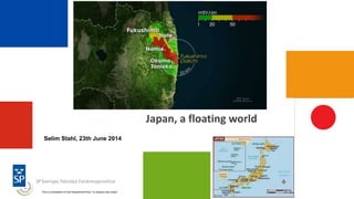
- 1. Japan, a floating world Selim Stahl, 23th June 2014 This is a translation of Arte Geopolitical Show ”Le dessous des cartes”
- 2. Three years after the tsunami in March 2011, how is Japan? What are today's challenges of this island state? These maps discuss the consequences of Fukushima and examines the fragility of the world’s third largest economy.
- 3. Japan is located in North-East Asia, facing the Pacific Ocean and the sun rising. This is why it is nicknamed the "Land of the Rising Sun". This is also the symbol of the Sun that can be found on the national flag. As "lying" in the far east of Eurasia, Japan is almost 378,000 km ². JAPAN GEOGRAPHY
- 4. If we look at the maritime territory claimed by Japan, its area is multiplied by twelve, or 4.5 million km ², because of the exclusive economic zones generated by the 6,852 islands of the archipelago. This huge EEZ is an essential asset for a country where the sea plays such a major role, both in history and in culture or economy. And it's finally more the sea than the land that gives Japan its outer limits. THE EXCLUSIVE ECONOMIC ZONE (EEZ) OF JAPAN
- 5. But these limits are challenged by its three main neighbors. First the north by Russia, around the South Kuril Islands. Annexed by Stalin in 1945, Moscow has never returned them but they are seen as an integral part of Japanese territory. Moreover, no peace treaty was signed between the two countries after the Second World War. THE CONFLICT AROUND SOUTH Kuril Islands
- 6. Then in the west with Korea, around the rocks you see here. In Korea it is Korean islands, the Dokdo islands. For Japan, these are Japanese islands, called Takeshima. CONFLICT AROUND DOKDO / Takeshima ISLANDS
- 7. Finally in the south with China and Taiwan, around the Senkaku islands, called Diaoyu in Chinese and Tiaoyutai in Taiwan. This is undoubtedly the most serious issue for two reasons. On the one hand, there are oil resources offshore… CONFLICT AROUND Senkaku / Diaoyu Islands
- 8. …on the other hand, if we change the map scale we find that the shipping routes, starting from the Oil&Gas fields of the Middle East, pass through the East China Sea near the Senkaku to supply Japan. And these routes are very important since Japan do not have its own energy resources. The country is 92.5% dependent on fossil energy imports. MARITIME ROUTES BETWEEN THE MIDDLE EAST AND JAPAN
- 9. Since the Fukushima nuclear accident in 2011, Japan's energy policy is weakened. Before the disaster, in 2010, Japan was the third largest producer of nuclear power after the United States and France. Nuclear then provided 30% of the country's electricity, and Tokyo planned to increase this to 50% by 2030. But the Fukushima accident, due to the tsunami of March 11, 2011, led to the shut-down of the 54 reactors in the country. The Japanese government made a commitment to put an end to Japan's dependence vis-à-vis nuclear and develop renewable energy. A NEW ENERGY POLICY?
- 10. Japanese authorities want to make Fukushima Prefecture a center for green energy. First, in Koriyama, 60 km from the power plant, was opened in spring 2014 the Fukushima Renewable Energy Institute, dedicated to research on green technologies. Its goal is that by 2040 renewable energies provide all the energy needs of Fukushima prefecture, for about 2 million inhabitants. Fukushima Prefecture, NEW GREEN ENERGY CENTRE?
- 11. What is the human toll three years after this catastrophe? You can see from this map different areas. The red areas are the most severely contaminated and will remain closed to residents as long as the Cesium 137 (which is a radioactive element) eventually disintegrate naturally. Yellow areas where radioactivity is still too high: people can return pick-up things in their homes for a few hours every three months. The government promises that the yellow areas will reopen in less than ten years. Finally the green areas where the exposure dose is between 1 and 20 millisieverts/year border the forced evacuation zone and include the 20 km exclusion area around the powerplant. It is open only during the day and should be reopened to the public in 2014 or 2015. HUMAN TOLL THREE YEARS AFTER THE FUKUSHIMA DISASTER
- 12. This curve shows the evolution of Japan's public debt since 1984. It exceeds 200% of GDP in 2011, more than two years the country's GDP, and it reaches 233% of GDP in 2014. Japan, the third world power behind the United States and China, is also the most indebted of industrialized countries. This public debt is held almost entirely by the Japanese. So for the Japanese government, the cost of debt financing is very stable at a very low level. EVOLUTION OF THE JAPANESE DEBT
- 13. The Japanese population is not renewed. You can see from this curve that the Japanese population not only does not increase, but actually decreases. According to the Statistical Office of Japan, the country had 128.1 million inhabitants in the last census in 2010 and 127.3 million people in 2013. In addition, the Japanese population ages. People over 65 form today more than 20% of the population and they will be 40% of the Japanese population in 2060. And an aging population means a reduction of the workforce, which will weigh on the economic activity in the country. EVOLUTION OF THE JAPANESE POPULATION
- 14. Natural Gas in Japan is growing. Here are some SP Gas Services: Metering of LNG Analysis of natural gas & biogas composition Life Cycle Assessment and Environmental Impact Assessment of alternative fuels like shale gas, biogas, synthetic natural gas etc Life Cycle Cost analysis of new designs Fire Safety Analysis of LNG refueling systems Research into the durability of natural gas pipelines (emphasis on optimisation of materials, designs and methods of laying, in order to minimise investment costs)