Digital Survey Kerala SOP - Standards Operational procedures - Uploaded by James Adhikaram land problem Solvers Kottayam 9447464502. Please like the presentation before download .

Digital Survey Kerala SOP - Standards Operational procedures - Uploaded by James Adhikaram land problem Solvers Kottayam 9447464502. Please like the presentation before download .The massive digital survey as part of the ‘Ente Bhoomi’ programme will begin in the state on November 1. The first phase will cover 200 revenue villages across all 14 districts. Ahead of the survey, people of these villages have been asked to cross-check details of their land available on the Ente Bhoomi portal www.entebhoomi.kerala.gov.in. The 200 villages have been listed on the portal. Owners can register with the website and enter their survey number and sub-division number to view details. If details of one’s land are not available on the portal or in case of mistakes, a complaint can be raised through the portal itself. Copies of supporting documents should also be uploaded. “The government is making a comprehensive database integrating the land-related data with the revenue, registration and survey departments. Before the new survey, people should ensure that their land details on the portal are error-free. They should also cooperate with the surveying officers. When finalised, the new survey map will become the authentic record of one’s land parcel,” said an officer in the survey department. The survey will be launched by Chief Minister Pinarayi Vijayan on November 1. Survey Sabhas or ward-level meetings to educate people on the new survey are being conducted in the selected villages. The time of the survey will be intimated through various channels, local-level public meetings and notification through different media. Owners have to be present at the spot with the registration deed and Aadhaar card. NRKs or others who cannot be present can assign proxies. Bushes and shrubs on the land borders should be cleared before the survey officers’ visit. Boundaries should be marked. It will be better to settle petty border disputes before the survey. Or else, the land holdings under dispute will be shown as a single unit on the new map until the issue is settled. The officers will show the draft map on their tab in case of doubts. The draft will later be made available on the Ente Bhoomi portal for corrections. Public buildings to be marked The government land will also be surveyed and public buildings will be marked. Topographical details like roads, canals, streams, ponds and backwaters will also be mapped. The final product will be a GIS database which will help in the total digitisation of land transfers and records maintained by survey, registration and revenue departments. It will also help in disaster management activities. The new survey will cover 1,550 of the total 1,666 villages in Kerala in four years. Excluded are 95 villages where the digital resurvey was completed earlier and 21 where it is going on.

Recommended
Recommended
More Related Content
What's hot
What's hot (20)
Similar to Digital Survey Kerala SOP - Standards Operational procedures - Uploaded by James Adhikaram land problem Solvers Kottayam 9447464502. Please like the presentation before download .
Similar to Digital Survey Kerala SOP - Standards Operational procedures - Uploaded by James Adhikaram land problem Solvers Kottayam 9447464502. Please like the presentation before download . (20)
More from Jamesadhikaram land matter consultancy 9447464502
More from Jamesadhikaram land matter consultancy 9447464502 (20)
Recently uploaded
Recently uploaded (20)
Digital Survey Kerala SOP - Standards Operational procedures - Uploaded by James Adhikaram land problem Solvers Kottayam 9447464502. Please like the presentation before download .
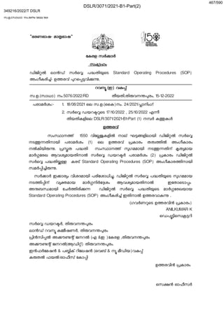
- 1. "ഭരണഭാഷ- മാ ഭാഷ" േകരള സർ ാർ സം ഹം ഡിജി ൽ ലാൻഡ് സർെ പ തി െട Standard Operating Procedures (SOP) അംഗീകരി ്- ഉ രവ് റെ വി . റവന (ഇ) വ ് സ.ഉ.(സാധാ) നം.5076/2022/RD തീയതി,തി വന രം, 15-12-2022 പരാമർശം:- 1. 18/08/2021 െല സ.ഉ.(ൈക)നം. 24/2021/ ാനിംഗ് 2. സർെ ഡയറ െട 17/10/2022 , 25/10/2022 എ ീ തിയതികളിെല DSLR/3071/2021-B1-Part (1) ന ർ ക കൾ ഉ രവ് സം ാന ് 1550 വിേ കളിൽ നാല് ഘ ളിലായി ഡിജി ൽ സർെ നട തിനായി പരാമർശം (1) െല ഉ രവ് കാരം തത ിൽ അംഗീകാരം നൽകിയി . ത പ തി സം ാന ് ഗമമായി നട തിന് ത മായ മാർ േരഖ ആവശ മായതിനാൽ സർെ ഡയറ ർ പരാമർശം (2) കാരം ഡിജി ൽ സർെ പ തി കരട് Standard Operating Procedures (SOP) അംഗീകാര ിനായി സമർ ി ി . സർ ാർ ഇ ാര ം വിശദമായി പരിേശാധി . ഡിജി ൽ സർെ പ തി െട ഗമമായ നട ി ിന് വ മായ മാർ നിർേ ശം ആവശ മായതിനാൽ ഇേതാെടാ ം അ ബ മായി േചർ ിരി ഡിജി ൽ സർെ പ തി െട മാർ േരഖയായ Standard Operating Procedures (SOP) അംഗീകരി ് ഇതിനാൽ ഉ രവാ . (ഗവർണ െട ഉ രവിൻ കാരം) ANILKUMAR K െഡപ ിെസ റി സർെ ഡയറ ർ, തി വന രം ലാൻഡ് റവന ക ീഷണർ, തി വന രം ിൻസി ൽ അ ൗ ് ജനറൽ (എ &ഇ )േകരള ,തി വന രം അ ൗ ് ജനറൽ(ആഡി ്) തി വന രം. ഇൻഫർേമഷൻ & പ ിക് റിേലഷൻ (െവബ് & ന മീഡിയ)വ ് ക തൽ ഫയൽ/ഓഫീസ് േകാ ി ഉ രവിൻ കാരം െസ ൻ ഓഫീസർ സ.ഉ.(സാധാ) നം.5076/2022/RD DSLR/3071/2021-B1-Part(2) 349216/2022/T DSLR 467/590
- 3. KERALA SURVEY AND LAND RECORDS DIGITAL LAND SURVEY STANDARD OPERATING PROCEDURE - Version. 1 DSLR/3071/2021-B1-Part(2) 349216/2022/T DSLR 469/590
- 6. 3 CONTENTS 1. INTRODUCTION 5 2. PRELIMINARIES 6 3. OBJECTIVES 7 4. METHODOLOGY 7 5. AWARENESS PROGRAM 9 6. COLLECTION OF RECORDS 10 7. VILLAGE BOUNDARY DEMARCATION AND SURVEY 12 8. DIGITAL SURVEY OF GOVERNMENT/GOVERNMENT INTERESTED LANDS 18 9.DEMARCATION AND SURVEY IN REGISTERED LANDS 26 10. PREPARATION OF LAND REGISTER 29 11. INSPECTIONS 33 12. ORIGINAL LAND COMPLAINT (OLC) AND SETTLEMENT 38 13. APPEAL LAND COMPLAINTS (ALC) AND SETTLEMENT 41 14. SETTLEMENT ISSUES 44 15. PREPARATION OF FINAL RECORDS 45 16. PUBLICATION OF FINAL RECORDS 48 17. Explanation 49 18. Important Forms 50 Form No.4 50 Form No.5 51 Form No. 16 52 Form-16A 54 Form No. 17 56 FORM No. 18 57 Form No. 29 58 Form -29 (a) 59 Form No. 30 60 Form No. 50 61 FORM - 61 63 DSLR/3071/2021-B1-Part(2) 349216/2022/T DSLR 472/590
- 7. 4 FORM -64 65 FORM NO.66 69 FORM NO.67 71 FORM NO.68 73 FORM NO.69 75 FORM No. 70 77 FORM No. 71 78 FORM No. 72 79 FORM No. 73 80 Form No. 74 84 Form No. 75 85 FORM- 168 87 FORM -169 89 FORM No - 170 90 FORM No - 171 92 Topo Details 93 DSLR/3071/2021-B1-Part(2) 349216/2022/T DSLR 473/590
- 8. 5 1. INTRODUCTION 1. The Department of Survey and Land Records is one of the oldest departments under the Government of Kerala. The main responsibility of the department is to prepare the land records for the Revenue Department to facilitate Land Administration. Out of the 1,666 villages in the State, the resurvey of only 913 villages has been completed till date. In 25 villages, digital survey is in progress and 728 villages are still remaining to be resurveyed . All the villages except 91 villages were surveyed by using conventional methods (Chain, Cross staff, Theodolite etc.) and the records were prepared as paper maps in the local coordinate system. Since the records are hardcopy in nature and do not have a universal coordinate system, digitising and bringing them into WGS84 standard seems impractical, the sole resolution for this is a fresh digital survey of the entire state. 2. An integrated land information system will be introduced to overcome all the existing problems. The new system will facilitate creation, administration, organization and management of all aspects of land (information, management, control, usage) in a unified manner which is the need of the hour. It facilitates quick and secure land based marketing as well as speedy and secure land transactions. It provides reliable and real-time land information to the government and the public. DSLR/3071/2021-B1-Part(2) 349216/2022/T DSLR 474/590
- 9. 6 2. PRELIMINARIES 1. Before the digital survey can be undertaken it should be sanctioned by the Government or any officer or authority authorised by the Government on this behalf and a notification published in the Kerala Gazette under section 4 of the Kerala Survey and Boundaries Act (Act 37of 1961). 2. The Director, Survey and Land Records should communicate the probable date of commencement of Digital survey operations in each Taluk / Village to the respective District Collectors. 3. Before the commencement of the Digital survey, the collector should obtain sanction of the Government for any proposal to subdivide any of the existing villages or to alter the boundaries of the existing villages or Taluks which may be necessary for any reason and furnish to the officer- in- charge of the survey party a detailed statement of changes sanctioned. 4. When the Digital survey is ordered under Kerala Survey and Boundaries Act section 4 or section 5, the Survey Officer concerned (generally the Assistant Director) will publish a notification in Form No.16 under section 6 of the Act in the e-Gazette and also in printed media, inviting all persons having any interest in the land or in the boundaries of which the survey has been ordered, to attend either in person or by representative at a specified place and time and from time to time thereafter when called upon for the purpose of pointing out boundaries and supply information in connection therewith. 5. Where however, the survey has been ordered to be conducted under section 7 defraying the cost of survey operations in the first instance by Government, the notification under 6 of the Act should be published in the Kerala Gazette in Form No. 17. 6. The officer in charge of the survey party will prepare an estimate of the total number of survey marks required for each village boundary and Government lands. DSLR/3071/2021-B1-Part(2) 349216/2022/T DSLR 475/590
- 10. 7 3. OBJECTIVES 1. Establishment of a CORS (Continuously Operating Reference Stations) Network across the state. 2. To provide land record access for each beneficiary. 3. To provide digital land survey records in an online platform. 4. To achieve the above mentioned targets, the digital survey of the entire State should be completed within a fixed time frame. The successful completion of the project will have a far reaching positive impact on overall economic prosperity and harmony. 5. Following are the specific objectives set out for building a strong and resilient Kerala in the Land Sector and they are, ● To bring accuracy and precision to the land survey process. ● To provide digital delivery of a topographical 3D map. ● Generate multipurpose cadastral data base for the use of various departments of the Government. ● To provide integrated spatial data of stakeholder departments like Revenue, Survey and Registration. ● To complete the digital survey of all villages by using the latest survey technology. ● To integrate the land record service delivery of three main stakeholder departments (Survey, Revenue, and Registration) ● To impart training and capacity building of departments concerned. ● To improve technology and IT infrastructure to build a strong framework of digitally enabled cadastral systems. DSLR/3071/2021-B1-Part(2) 349216/2022/T DSLR 476/590
- 11. 8 4. METHODOLOGY 1. The project intends to use a combination of modern technologies such as CORS (Continuously Operating Reference Station) & RTK (Real Time Kinematic), Drone and RTS(Robotic Total Station) for the survey according to the topography. It is expected that out of the 1550 villages (36,543 sq. km) about 20% of the area can be surveyed by using Drone, about 60% of the area can be surveyed by using CORS + RTK and other 20% of the area can be surveyed by using ETS. 1.1 Drone- The areas where more open space and built up land are available that area can be surveyed with the Drone and LiDAR technology. Kerala has around 20% of land covered by paddy fields, back waters, rivers, rails, roads and open grounds which can be surveyed by using Drones. 1.2 CORS and RTK – A Continuously Operating Reference Station (CORS) network is a network of Real Time Kinematic (RTK) base stations. It usually improves the accurate positioning of a station over an internet connection. More than one station helps to ensure correct positioning and increase accuracy in a CORS network, and protects against errors that may occur if the survey is based on only one base station. This technology will bring more efficiency, accuracy, etc. in the survey works of Kerala. 1.3 RTS Survey – A Robotic Total Station is a total station that allows remote operation. This can perform far more calculations and inspections in less time than a traditional Total station. It is a more time consuming method compared to RTK. The advantage is that this technology can be used where there is tree cover and low satellite signal areas. DSLR/3071/2021-B1-Part(2) 349216/2022/T DSLR 477/590
- 12. 9 5. AWARENESS PROGRAM Public participation is very important in Digital survey Activities. The land owners need to be aware of the importance of the survey and how their land and land records are being protected. The survey in a village is started by giving adequate publicity. 1. Maximum involvement of the public will be ensured through the participation of ward members of the local governing bodies concerned as well as Residents’ Associations, Gramasabha, Kudumbasree, Political Parties etc. 2. There should be a special Gramasabha called Survey Sabha in each ward in the village. For imparting information regarding digital survey, a head draftsman/head surveyor should work as a resource person in each ward. 3. A significant Public Engagement Activity (PEA) will be required to support the Digital survey activity. This PEA will focus on the Digital survey and seek to ensure that the land owners/representatives participate actively in the Digital survey activity. The PEA also supports the key stages in the Digital survey (demarcation of registered lands, collection of evidence of rights, public display etc.). 4. A professional agency will prepare the strategy,design the PEA and develop materials for the PEA. Implementing the PEA will require the preparation of PEA materials (videos, posters, brochures, leaflets, Q&A material etc.) and media time (TV, newspapers, social media, etc.). The PEA will be implemented by the staff undertaking the Digital survey with the guidance and advice provided by the external agency. DSLR/3071/2021-B1-Part(2) 349216/2022/T DSLR 478/590
- 13. 10 6. COLLECTION OF RECORDS 1. The District Collector should instruct the revenue officials concerned to furnish the sketches and supporting files of Government land including Poramboke, Tharissu, Puthuval, Kuthakapattom, Surplus land, Land acquisition, Land Assignment, Land Relinquishment etc .with survey number, subdivision number, area, nature of Government land, etc. in their office to the Officer-in-charge of the digital survey party before the commencement of digital survey in each village. 2. The Officer-in-charge of the digital survey party of State/District level shall receive the following records of the notified Village for Digital Survey from the available sources. 2.1. State boundary traverse data with offset and side 2.2. Village boundary Traverse data with offset and side 2.3. Village map/block map/litho 2.4. FM sketches/blue print/divided sketch. 2.5. The latest updated ReLIS data authorized by the Tahsildar concerned. 2.6. The latest updated PEARL data from the Registration department. 2.7. List of Ground Control Points (GCPs) on the notified area. 2.8. Settlement Register/BTR. 2.9. Poramboke Register. 2.10. Tharissu Register. 2.11. Records of Ni ke land 2.12. Records of Assignable waste land 2.13. Records of land under Escheats and forfeitures act. 2.14. Records of Kuthakapattom. 2.15. Records of Surplus land. 2.16. Records of Pattaya lands. 2.17. Records of Land Acquisition. 2.18. Records of Land Assignment. 2.19. Records of land tribunal pattayam 2.20. Records of Land relinquishment 2.21. Records of Forest land. DSLR/3071/2021-B1-Part(2) 349216/2022/T DSLR 479/590
- 14. 11 2.22. Records of Bought-in-land.88888y7 2.23. Geo-referenced survey maps from CDC & DDC. 2.24. Geo-referenced Litho maps from KSREC (Kerala State Remote sensing and Environment Centre). 2.25. Records of Devasom Lands. 2.26. Area register 3. The entire land records available would be digitized and made available to the survey teams to speed up the activities. This could be done in CSO, Mapping Offices, Centre Digitization Centre (CDC) and District Digitization Centre (DDC). 4. Before the commencement of digital survey in each village, the available survey records pertaining to that particular village need to be collected and scanned by the Draftsman or Surveyor. Metadata should be prepared and uploaded to the software. 5. The uploaded records have to be verified and approved by the Head Draftsman or Head surveyor. During the course of approval any document found to be inappropriate or incorrect should be rejected or returned to the Draftsman or Surveyor for re-uploading. The rejected or returned records should be uploaded again with relevant corrections made and forwarded again for approval. 6. The records thus approved should be available for reference during field work and also available for the public as per rule. 7. The village map, block map, litho or other relevant sketches should be scanned, vectorized, geo referenced and made available in IT applications for preparing demarcation sketches. 8. After the collection of the records, a list of collected records from each office should be provided to all officers concerned through ‘ente bhoomi’ portal. If any of the records are available other than the list in their custody should be produced within 15 days from the date of publication of the records. After that period, the officer in charge of the survey party DSLR/3071/2021-B1-Part(2) 349216/2022/T DSLR 480/590
- 15. 12 finalises the list of old survey records. If any records found in the office after the digital survey process, should be considered as the lapse of responsibility by the officers who kept those records. 9. An extract of records should be prepared and kept ready in the ‘ente bhoomi portal’ before the surveyors are deputed for field work. Surveyors will do the field work using these records. DSLR/3071/2021-B1-Part(2) 349216/2022/T DSLR 481/590
- 16. 13 7. VILLAGE BOUNDARY DEMARCATION AND SURVEY 1. In the case of a Village boundary traverse survey, the previous or old traverse survey need not be followed scrupulously. 2. Before commencing to fix the stations on the village boundary, it is necessary that a sufficient number of stones should be stocked at convenient centres. 3. Before commencing to fix the village boundaries, the surveyor deputed for boundary demarcation should give a notice in Form No. 29 to the village authorities on both sides of a boundary about to be demarcated. 4. When lands near the boundary are occupied, notice should also be sent to the registered holders and occupants of such lands in Form No. 30. 5. All notices under the Survey and Boundaries Act and the rules issued thereunder will generally be served through the Village Field Assistant. 6. When surveying village boundaries, only the geo-coordinates of the existing village boundary points are collected. However in case the roads and canals become village boundaries, they should be surveyed to include them in a village without restoring the old boundary if they have widened as per the status quo. 7. Before demarcating a district boundary, the officer in charge of the survey party will inform the Collector of both the districts and request them to appoint revenue officials to assist and give information in case of disputes. Similarly before demarcating a Taluk boundary, the Tahsildars of both the Taluks should be addressed to ensure necessary help. 8. In demarcating the State boundary, the boundary line which has been settled and accepted by the two States should be followed. If any additional demarcation stones have to be planted, they should be planted exactly on the accepted boundary. 9. Where the boundary between two states has not been previously demarcated and surveyed, it should be demarcated and surveyed by the representatives of both the states in accordance with the alignment accepted by the States. In such cases the officer in charge should DSLR/3071/2021-B1-Part(2) 349216/2022/T DSLR 482/590
- 17. 14 request the government through the Director of Survey and Land Records to address the adjoining state government for deputing staff for joint demarcation. The demarcation and planting of stones on the boundary can be made only after acceptance of the alignment of the boundary by both States. 10. When reserved forests adjoin the village, the boundary should be demarcated by fixing the stone close to the cairns or other marks put up by the Forest Department. But the number of such stones should be reduced by engraving with the consent of the Forest Department, the coconut tree mark and plummet hole on the forest boundary pillars where such exist and can be utilised as survey stations. 11. When the forest cairns or pillars are not placed on the outer edge of the cleared line as required by the Forest Demarcation Rules, the survey stones should be planted on the outer edge only and not too close to the forest marks. 12. When forests adjoin the village, the boundary should be demarcated in the presence of the Forest Department. 13. Where a river forms the village boundary and if it is more than 20 m wide, survey marks should be erected on each bank, and the middle of the river will be considered as the true village boundary, provided, however, that existing rights are not interfered with. The stones so erected must be capable of being protected from floods and erosion in order to secure this. 14. When defined rights to land exist within the river bed, they must be recorded and the occupation shown on the boundary demarcation sketch. 15. In case of villages that exist at seashores, 15.1. The high and low water levels should be surveyed at the survey of maritime villages. Surveyors should be in a position to fix the high water level with accuracy by personal observation at new moon or full moon. Low water levels should be indicated by dotted lines in black ink. DSLR/3071/2021-B1-Part(2) 349216/2022/T DSLR 483/590
- 18. 15 15.2. The boundaries of these villages along the coast will follow the ayacut, subject to such modification as may be necessitated by reason of encroachment or recession of the sea. 15.3. The high tide line should be observed and recorded in the same way as any other village boundary. 15.4. The line of low tide, that is the tide line reaches about six days before the full or new moon should also be surveyed, but not demarcated and should be shown in the village map by dotted lines. It will of course run outside the high tide line, which should also be shown by dotted lines. 16. The village should be divided into Digital Blocks of 10 hectares to 20 hectares for field work. Digital block boundaries should be chosen as the existing natural boundaries without splitting the existing survey numbers as far as possible.The maximum area limit of digital blocks may vary in some cases if there is a revenue field with an area greater than 20 hectares. 17. Digital blocks of a village can be prepared in software with the help of geo referenced maps and satellite imageries, by the Head surveyor/Head Draftsman/authorised by the officer in charge of the survey party. After the formation of digital blocks, it should be sent to the Superintendent of survey for verification. The Superintendent of survey should verify these digital blocks, and any discrepancies should be corrected before being sent to the Assistant Director for approval. 18. The Assistant Director should approve these digital blocks and send them back to the superintendent of survey.The superintendent of survey should send the digital blocks to the Head surveyor for field work. 19. Stones on Village boundaries not fixed by the Surveyor who prepares the sketch should be shown in black ink and all new boundaries and stones newly planted in red ink. The symbols to be used are ∆ for Village trijunction, + for Village boundary stations, for Rock mark station. DSLR/3071/2021-B1-Part(2) 349216/2022/T DSLR 484/590
- 19. 16 20. Before the commencement of the digital survey, village boundary traverse data and off set and side data or FM sketches adjacent to the village boundary should be plotted in the prescribed software by the Draftsman or Surveyor for refixing work. 21. Such plotted sketches and scanned copies of those sketches will be available to the field through IT applications. 22. Surveyor refixes the village boundary according to these sketches. 23. During the demarcation of the village boundary, the surveyor shall identify the village stones that are intact on the ground by using existing traverse data. The surveyor shall observe Geo-code of maximum such points and convert the existing traverse data and offset and side data into Geo-cods using software in the system. 24. After generating Geo-cods for the village traverse, stakeout all the points on the ground. If the existing survey mark is intact on ground and the stakeout point is found deviated, finalize the existing point and see that all village traverse points are refixed with reference to existing data. 25. After refixing the village boundary points using offset and side data and see that all village boundary points are refixed on the ground accurately. In this process , if the existing survey mark is intact on ground and the stakeout point is found deviated, finalize the existing point and see that all village boundary points are refixed with reference to existing data. 26. If the old survey records of the village boundary are not available for refixing or if it is appropriate to refix the village boundary as per FM sketches adjacent to the village boundary, the village boundary can be re-fixed using geo-cods of that FM sketch. 27. If it is not possible to conduct a survey based on Geo-cods in any of the above cases, the survey can be done manually. 28. The existing survey marks will continue to be permanent survey marks and all missing stones shall be planted. Every survey stone must be firmly embedded. 29. Then observe and record geo-cods of village boundary points and generate village boundary data. This new data shall be followed to the adjacent village for digital survey. DSLR/3071/2021-B1-Part(2) 349216/2022/T DSLR 485/590
- 20. 17 30. Any dispute that arises while refixing or finalizing the village boundary shall be referred to the next level inspecting authority, before finalization. The inspecting authority shall conduct a survey u/s 10(1) and announce a decision under section 10(2). 31. The sketch should be signed with the surveyor’s login credentials. Also an abstract showing the number of survey marks used for Village boundary. 32. After completion of village boundary maps,a thorough quality check shall be conducted for overlaps or gaps in the computer itself by the survey officer appointed by the officer in charge of the survey party. 33. A comparative statement of the existing village area and the new area determined shall be prepared and examined for area variations. Wherever, there is larger variation in the old and new extents, the reason should be recorded there in. DSLR/3071/2021-B1-Part(2) 349216/2022/T DSLR 486/590
- 21. 18 8. DIGITAL SURVEY OF GOVERNMENT/GOVERNMENT INTERESTED LANDS 1. The digital survey follows the state of things on the ground. The existing survey data i.e.Field Measurement Sketches need not be refixed on the ground to correlate the new land parcels with the existing FM sketches. Only where the appeals filed by the aggrieved will be surveyed in detail to trace out the reasons for such variation or deficiency in extent. However, this principle of survey as per enjoyment does not apply to Government lands as these lands are more vulnerable to encroachment. 2. The Tahsildar should update the ReLIS data and Field Measurement sketch for all changes on Government/private land due to land assignment, acquisition, other cases etc. 3. The digital survey follows enjoyment, but when it comes to the Government land, it should be refixed in accordance with the updated records which are certified by the authorised officer, who is the custodian of the records. 4. All the FM sketches related to all Government/Government Interested land of every village has to be collected and digitized before digital survey. The Government/Government interested lands shall be refixed with reference to the existing data. 5. Before demarcating the boundaries of roads belonging to the Government or road belonging to local bodies or vested in channels or lands belonging to PWD , reserve forest , etc. notices must be sent by the section officer to the local officers concerned to depute a responsible subordinate to attend with the records including sketches in their possession and point out boundaries of their land. The subordinates deputed should certify to the correctness of the demarcation of the land and the certificate should be filed with the records of the village. If there is any difference between DSLR/3071/2021-B1-Part(2) 349216/2022/T DSLR 487/590
- 22. 19 the boundaries pointed out by them and by the ryots, the matter should be reported to the officer-in-charge for orders. 6. When a road runs through Government waste lands, its limits should be marked at a maximum distance of 20 metres on either side from the centre of the roadway. 7. Before demarcating the boundaries of Railway lands, the local Railway Authorities should be consulted and asked to produce copies of land plans that were prepared for the Railway. 8. Railway lands are broadly divided into four classes:- A,B, C and D. Class A, lands which the railways received for permanent occupation Class B, lands provided for temporary occupation. Class C, lands which railways require for actual execution of work ; and Class D lands which are required in consequence of the works for a railway, still do not come directly into the occupation of railway. 9. class ‘A’ consist of all lands required for the permanent works of the railway including the formation of lines with its side slopes, beams, ridges, etc. and for all stations, workshops, permanent store-house and the like necessary for the line when opened. 10. class ‘B’ consist of all lands essential for the execution of the permanent works of the railway but not required after the completion of the line in part or whole, such as lands required for spoiled banks, for extra excavations to make banks or for the storage of materials held in stock pending the construction of the line or their despatch to the works. 11. class ‘C’ consist of all lands which are required for the provision or preparation of materials for purposes contingent on the actual execution of the works on the line or for other miscellaneous objects. DSLR/3071/2021-B1-Part(2) 349216/2022/T DSLR 488/590
- 23. 20 12. class ‘D’ consist of all lands required outside the railway premises for the diversion of roads or rivers and for the construction of roads which are made for public purpose but will not afterwards be maintained by the railway. 13. In such cases each class of land should be demarcated and surveyed as a separate land parcel. 14. Cultivation in forest blocks, if recognized as enclosures should be marked separately according to the existing limits on the ground. If the area of an enclosure thus marked is more than that allowed at the forest settlement, the excess should be formed as a separate sub-division and the fact reported to the Forest authorities for further action. 15. There is every possibility of either the deposition of new land or erosion of existing land in the case of heavy flowing water bodies like rivers, streams and vagus etc.due to the change of its course over a period of time. In all such cases, the original boundaries shall be restored as per existing data. If the recorded land is eroded, such land should be demarcated as per existing FM sketches and the portion of eroded area should be shown in broken lines to that effect with the land parcel number in continuation. 16. If part of the survey number is eroded, the available land on the ground will be surveyed and shown boundaries as usual and the remaining eroded portion of land should be shown in broken lines but the area of such a land parcel shall be the available land only and the eroded area will be recorded in remarks column with details. 17. There is a possibility of deposition of new land in the case of water bodies like sea, rivers, streams etc over a period of time. In such cases newly formed land should be demarcated and surveyed in the village and given a land parcel number in continuation. In case of land deposited by sea, it should be recorded as Kadal puramboke in the Land Register. DSLR/3071/2021-B1-Part(2) 349216/2022/T DSLR 489/590
- 24. 21 18. Private land adjoining government land and currently diverted to government land as part of development activities but not acquired by the government should be surveyed only in the name of the concerned Government department. 19. The minor circuit (MC) fields like hill poramboke, water bodies etc. shall be refixed with reference to the existing MC data in the same procedure adopted in case of village boundary demarcation and traverse data. 20. In case the MC data is missing, those MC should be refixed with reference to the adjacent FMBs by converting the FMB data into Geo- Cods data. 21. In case the MC field does not have MC data and is not plotted to Scale, i.e. rough shaped sketches recorded with rough area should be re-fixed with reference to adjoining FMBs using Geo-Cods. 22. In cases where the MC data is either missing or not prepared initially, the adjacent FMBs in continuation are also missing, the shape and size plotted in the Village map should be taken into consideration. But the area should not be reduced. 23. In case the occupation is assignment in nature without block splitting of the MC field, as duly recorded in revenue accounts, such enjoyment should be surveyed as per the state of things on the ground, while protecting the MC field boundary as the Government’s claim is permanent in nature. 24. During the field demarcation of Government land other than MC, the surveyor should identify the survey stones of government land which are intact on the ground as far as possible using FM sketches. It should be marked on the field demarcation sketch. The surveyor shall observe Geo- cods of maximum such points during detailed survey. Using these Geo- cods convert the missing stones into geo-cods in the system. DSLR/3071/2021-B1-Part(2) 349216/2022/T DSLR 490/590
- 25. 22 25. After generating Geo-cods for each government land, stake out all the points on ground. If the existing survey mark is intact on the ground and the stakeout point is found to be deviated, finalize the existing point. But the area of the Government land should not be reduced if the dimensions of the land do not fully match with the dimensions of the existing sketches. 26. If the survey stones of Government lands are found to be missing or sufficient number of stones are not obtained during demarcation, those government lands shall be refixed with reference to the adjoining FM sketches. 27. If it is not possible to conduct a survey based on Geo-cods in any of the above cases, the survey can be done manually. 28. If the survey sketches of Government land and the adjoining FM sketches are missing, the shape and size plotted in litho/block maps should be taken into consideration. But the area should not be reduced. 29. In cases where the government land cannot be refixed in any way under the preceding paragraphs or no records are available so that it is not possible to identify in which part of the survey number the land comes, if any land exist in the same nature as in the previous record in that survey number, it should be surveyed after refixing that survey number. If the area is less than the previous area, all the land holdings included in that survey number can be surveyed and the existing documents and previous documents of each holding should be verified and based on that, the encroached land can be found. 30. After refixing Government lands as per procedure, the surveyor shall measure and simultaneously prepare the field register accordingly. 31. In Land acquisition cases the designated departmental local officer of the concerned department is responsible for producing authorised evidence. After completion of the survey, the officer concerned with that department DSLR/3071/2021-B1-Part(2) 349216/2022/T DSLR 491/590
- 26. 23 can check it through their login and if any discrepancies are found they can submit an application for revision through the portal. 32. In some cases, the existing roads/canals are not recorded in any land records but the entire extent of survey/subdivision number is registered in the name of a private landholder and that land is used for public purposes. In all such cases, the state of things on ground shall be surveyed and registered as Nalathu Poramboke land and objections if any with proper evidence shall be recorded in remarks. 33. When forests are in the village, the forest boundary should be demarcated in the presence of the Forest Department. 34. When the forest cairns or pillars are not placed on the outer edge of the cleared line as required by the Forest Demarcation Rules, the survey stones should be planted on the outer edge only and not too close to the forest marks. 35. When a reserve forest is in the village, the boundary should be demarcated by fixing the stone close to the cairns or other marks put up by the Forest Department. But the number of such stones should be reduced by engraving with the consent of the Forest Department, the coconut tree mark and plummet hole on the forest boundary pillars where such exist and can be utilised as survey stations. 36. All the FM sketches related to the forest have to be collected and digitized before the survey. The forest lands shall be refixed with reference to the existing data. 37. During the demarcation of the forest boundary, the surveyor shall identify the boundary stones which are intact on ground by using existing previous traverse data. The surveyor shall observe Geo-cods of maximum such points and convert the existing traverse data into Geo-cods and generate Geo-cods of each traverse point in the system. 38. After generating Geo-cods, stakeout all the points on the ground. If the existing survey mark is intact on the ground and the stakeout points are DSLR/3071/2021-B1-Part(2) 349216/2022/T DSLR 492/590
- 27. 24 found to be deviated, finalize the existing point and see that all traverse points are refixed with reference to existing data. 39. If it is not possible to conduct a survey based on Geo-cods in any of the above cases, the survey can be done manually. 40. Where the forest traverse data is missing, those forest boundaries should be refixed with reference to the adjacent FMBs by converting the FMB data into Geo-Cods data. 41. Where the forest boundary MC data is not plotted to Scale, i.e. rough shaped sketches recorded with rough area should be re-fixed with reference to adjoining FMBs using Geo-Cods. 42. In cases where the forest boundary data is either missing or not prepared initially, if the adjacent FMBs in continuation are also missing, the shape and size plotted in the litho/block map should be taken into consideration. But the area should not be reduced. 43. Before the commencement of digital survey, sketches of all Government lands and if necessary sketches of land adjacent to government land will be plotted in the prescribed software by the Draftsman or Surveyor for refixing work. 44. If the sketches of Government land are missing, the adjacent sketches should be plotted. 45. If a Government land could not be refixed using available sketches, a sketch of convenient scale should be plotted using litho/block map of that land in software by Draftsman or Surveyor. 46. Such plotted sketches and scanned copies of those sketches will be made available to the field staff through an IT application. 47. The surveyor refixes the land according to these sketches. 48. When the Government lands are surveyed after refixing as per the old sketches, if the deviations in the measurements are more than the allowable limit, it should be reported to the Head surveyor. DSLR/3071/2021-B1-Part(2) 349216/2022/T DSLR 493/590
- 28. 25 49. The Head Surveyor should check it on the ground and finalize the records and also give necessary statements in the remarks column of the Land Register using his/her credentials. 50. In cases where government lands are entirely or partly occupied by adjacent land holders, demarcation and survey must be done as per existing records and the encroachment should be shown in the sketch in red colour as a separate layer, but should not be subdivided. The nature of encroachment should be recorded in the remark column in the land register 51. The surveyor need not prepare a refixing sketch while surveying the Government lands, but he/she must certify that all the government lands included in the block have been refixed. 52. The massive project ‘Ente Bhumi’ aims to scientifically prepare digital land records in the state to provide all land related services through an IT based online platform. As part of this project, useful information for various government departments such as roads, canals, natural resources, etc will be collected. 53. For preparing a ‘Multipurpose Cadastral Map’ that is useful for disaster management and increases the momentum of the development projects of the state, surveyors should observe for Geo-cods of important topo details listed in Appendix I. DSLR/3071/2021-B1-Part(2) 349216/2022/T DSLR 494/590
- 29. 26 9.DEMARCATION AND SURVEY IN REGISTERED LANDS 1. Before the commencement of field demarcation, the Survey officer should conduct a public meeting in the presence of the land holders of that village under the Chairmanship of the Grama panchayath president/ municipal chairman/corporation mayor and explain the schedule and plan of action for conducting the digital survey. Such schedule shall be displayed in Village office and at least any two conspicuous places in the village to give wide publicity regarding the commencement of digital survey operations in the village. 2. The Survey officer shall intimate the schedule of Public meeting well in advance to all persons interested through all effective available communications. 3. Land holders should be requested at the meeting to clear the boundaries of their properties and place survey marks before reaching the surveyor for field demarcation work. 4. The landholder may authorise his/her agent with written consent in Form-16A to attend the field in the absence of land holder for all purposes of such survey. 5. The survey officer shall, as and when necessary, give notice to the village officials requiring their attendance during demarcation. 6. A Geo-reference map showing the boundaries of previous survey and subdivision numbers should be included in the digital block prepared for the digital survey and supplied to the surveyor in IT application deputed for demarcation. 7. A Surveyor should then go to the field with the IT application and mark the boundaries of existing holdings. The names of present land owners should be gathered. DSLR/3071/2021-B1-Part(2) 349216/2022/T DSLR 495/590
- 30. 27 8. If the boundaries of any of the fields were not demarcated by the land holders, the boundaries of those fields must be demarcated by the surveyor. 9. In demarcating the boundaries of survey fields and subdivisions, the limits of enjoyment as seen on the ground should be followed as far as possible, unless there are valid documents to prove beyond all reasonable doubts, that the boundaries have to be demarcated otherwise. 10. During demarcation of each holding, the surveyor will gather the names of registered holders of the plot, its classification, revenue number, etc. as per the latest revenue records and as per the present enjoyment, for writing up the land register. 11. In all cases of discrepancy between established occupation and pre- settlement accounts, demarcation must follow the occupation and both should be recorded accordingly in the land register and the discrepancy must be explained in the remarks column of the land register. 12. Where the registered holder is absent or where the boundary between two revenue fields is disputed, the line must be laid down according to the village records or as ascertained from the village officials and from such other evidence as may be available. 13. If two or more previously existing revenue fields (still separately registered) which are contiguously situated have passed into the enjoyment of a single individual or the enjoyment of a number of persons who hold and enjoy them jointly and in common and are of the same classification and tenure, they should be formed into a single land holding. 14. A single land holding cannot be a combination of different classifications and tenure. 15. When there are bunds or hedges between holdings, the centre of these will, as a rule, be considered to be the true boundary, unless there is evidence to the contrary. DSLR/3071/2021-B1-Part(2) 349216/2022/T DSLR 496/590
- 31. 28 16. Every individual land holding should be surveyed as one land parcel and assigned a unique land parcel number within the village. The unique land parcel number shows the digital block number, and the land parcel number. 17. The tenure classification as it exists in the updated revenue list provided by the Tahsildar concerned should be adopted as it is. 18. The land register should be prepared in the prescribed form. The new land parcel numbers may be correlated to the old survey numbers/subdivisions. 19. During the digital survey, before the 9(2) publication, land parcels must be numbered consecutively throughout a block commencing from the North-West corner of the block. The last Land Parcel in the block must end at the South-East corner, so that there may be no break in the continuity of the land parcel numbers. 20. The surveyor should digitally sign the block map/land parcel map and also every entry in the Field Register. 21. Every demarcated boundary of a land parcel shall be observed for Geo- Cods. The Geo-Cods thus generated and recorded can be stakeout or relayed on ground very precisely at any moment. 22. The Observation of land parcels should be done using the GNSS Receiver/Robotic Total Station, based on the GNSS network. In the case of RTS survey in each day, survey should be started and ended at known value stations. 23. The surveyor should carefully survey to see that the common points or boundary between two land parcels is measured but once only so that there may be no difference between the measurements recorded for such common points or boundaries. 24. Arrows indicating the direction of streams should be inserted in the sketches. Care should be taken that the direction of the arrow shows the direction of the stream correctly. 25. While downloading land parcel maps from the website not more than one Land Parcel Map should be print on each page and one land parcel DSLR/3071/2021-B1-Part(2) 349216/2022/T DSLR 497/590
- 32. 29 should not occupy more than one page of legal size to be provided to the registered land holder, however, for maintenance purposes surveyor could be download a group of land parcels on a customized size of paper. 26. After completing the field survey, the area of each land parcel computed in the prescribed Software will be the digital survey area of that land parcel in the Land Register. 27. For quality check of the work, the land parcels in a block can be viewed under the percentage of difference in present revenue area and digital survey area. If the difference is above the limit, it will be verified in the field before being handed over to Revenue Authorities. 28. The surveyor/draftsman shall prepare a correlation map using the geo- referenced group sketch and the digitally surveyed sketch. 29. The Surveyor shall prepare Land Parcel Map and Field Register and handover to inspection authorities. 30. An online platform is necessary for the public to check their land details after completion of the detailed survey. DSLR/3071/2021-B1-Part(2) 349216/2022/T DSLR 498/590
- 33. 30 10. PREPARATION OF LAND REGISTER 1. The objective of the Digital survey is to survey each individual land holding as per enjoyment on ground against each land holding recorded in the latest updated revenue list. A Land register will be prepared based on the latest Revenue Records in Form No. 50 in all Rural and Urban areas. 2. A software such as Re-survey Management System (RMS) will help the field officer to prepare a Land Register at the time of field work. It may function on an IT platform. The guidelines to fill in the Land Register The entire field register is divided into 4 parts Part I- Column No. 1 to 4 As per Digital survey which shall be filled in by the Surveyor by conducting field survey. Part II – Column 5 to 14 and 16 As per revenue records (ReLIS data, Thandaper Register, etc) Part III – Column 15,17& 18 As per Digital survey which shall be filled in by the Surveyor by conducting field survey in presence of land holders Part IV – Column 19,20 Personal details of Registered Land holder and Remarks if any which shall be filled in by the Surveyor by conducting field survey in presence of land holders. DSLR/3071/2021-B1-Part(2) 349216/2022/T DSLR 499/590
- 34. 31 Part I Column No.1 : Name of Current Village and its number. Column No.2 : Current Digital Block Number. Column No.3 : Current land parcel Number. Column No.4 : Name of panchayath/Municipality/Corporation and Ward in which the land parcel situated . Column No.5 : Name of Village/desom as per existing Revenue Records Column No.6 : Block number as per existing Revenue Records Column No.7 : Survey number as per existing Revenue Records Column No.8 : Sub division number as per existing Revenue Records Column No.9: Tenure - Dry/wet/garden/ plantation/poramboke/ tarissu/converted land Column No.10 : Type of Land - Nilam ( specify whether kole, karipad, karinilam, palliyal), dry, poramboke, garden (coconut, Arecanut, cashew, pepper,) plantation (rubber, tea, coffee, cardamom), tharissu or converted land , etc. Column No.11 : Area of the land parcel as per existing Revenue Records Column No.12 : Thandaper No. and Name of Pattadar Column No.13: Tenure - Dry/wet/garden/ plantation/poramboke/ tarissu/converted land Column No.14: Type of Land - Nilam( specify whether kole, karipad, karinilam, palliyal), dry, poramboke, garden (coconut, DSLR/3071/2021-B1-Part(2) 349216/2022/T DSLR 500/590
- 35. 32 Arecanut, cashew, pepper,) plantation (rubber, tea, coffee, cardamom), tharissu or converted land , etc. Column No.15: Area of the land parcel as per present survey Column No.16: Name of the registered land owner Column No.17: Name of land occupied person. Column No.18 : Nature of land use Column No.19 : Personal details of the Registered Land Owner Column No.20 : Remarks if any . DSLR/3071/2021-B1-Part(2) 349216/2022/T DSLR 501/590
- 36. 33 11. INSPECTIONS 1. The assistant director of Survey and Land Records is the officer-in- charge and the Superintendent of survey and land records is the section charge of the field section. Each field section is divided into subsections, each under a Head surveyor. 2. The chief duties of inspecting officers are 2.1. To see that his subordinates do a fair amount of work and that the work is of good quality. 2.2. To keep the surveyors supplied with work and to arrange the distribution so that the least possible delay may be closed by travelling. 2.3. For every inspection made he should prepare an inspection report in the prescribed form. 3. The entire field survey work is divided into three heads – 3.1. Village boundary 3.2. Government/Government interested lands 3.3. Registered Land parcel boundary 4. The inspecting officer should see, while inspecting the village boundary demarcation work, 4.1. That all stones planted are of the prescribed size and good quality. 4.2. That they have been firmly and properly planted. 4.3. That not more than ⅓ of the length of the stone is visible above the ground. 4.4. That appropriate marks have been cut on the stone. 4.5. That the stones on village boundaries are planted exactly on the true boundaries except for widening of roads or canals etc. near the village boundary. 5. The accuracy of the Geo-Cods observed for demarcated village boundaries using RTK or RTS. DSLR/3071/2021-B1-Part(2) 349216/2022/T DSLR 502/590
- 37. 34 6. The deviation in measurement of the recorded village boundary points as already done by the surveyor from the measurement of the same boundary point on ground inspected by the inspecting authorities beyond the allowance (10cm) shall be treated as an error. 7. All errors either in demarcation or measurement of the village boundary should be rectified by the inspecting officer. 8. An inspection report in prescribed Form 61, shall be recorded when an inspection is conducted for the Village boundary by the inspecting authority. 9. The village boundary data should be checked by the Head surveyor so that the common boundaries are tallied and to avoid any overlaps or gaps in between. 10. The inspection of field survey consists of :- 1. inspection of registers and 2. inspection of demarcation and measurements. 11. The following will be treated as error in demarcation and registry:- 1. Demarcation in incorrect position. 2. omission or incorrect entry in land register. 12. In digital surveys, the entries in the Field Register shall be entered at the time of demarcation and measurement. The inspecting authority should see that the Field Register has been entered correctly at the time of completion of the survey of the land parcel. 13. Whenever necessary, the Inspecting authority shall conduct over check of the Geo-cods of selected land parcels using RTK/ Robotic Total Station and such Geo-Cods obtained during inspection should not deviate more than 10 cm ie, the deviation of Geo-Cods of two observations on same point should not exceed 10 cm. 14. The deviation exceeding the limit mentioned above shall be considered as an error in Geo-Cods on overcheck. 15. All errors either registry or demarcation or measurement of boundaries should be rectified and all omissions both on the ground and in the DSLR/3071/2021-B1-Part(2) 349216/2022/T DSLR 503/590
- 38. 35 records shall be incorporated in the concerned records by the Inspecting Officer using their login credentials. 16. The unit for determining the quality of the surveyor’s work will be the digital block. 17. The quality of work will depend on the percentage of error either in registry, demarcation or measurement. When the registry and demarcation are inspected at the same time, the items under each should be valued separately. Differences in measurements consequent on alteration of demarcation by inspecting officers should not be reckoned as errors in measurements. 18. The inspecting authority shall record all his inspections, whether the original work done is good, fair or bad. The original and inspector’s measurements must be given when errors are found. As part of the inspection, such measurements should be corrected by the inspecting authority using their login credentials. 19. The classification should be determined as follows Number of errors per 100 points measured 19.1. Below 5 Good 19.2. From 5 to 10 Fair 19.3. More than 10 Bad 20. Work classified as “bad” should, as a rule, be ordered for revision. When revision is ordered, the revising surveyor, who should not be below the grade of the original surveyor, should inspect the fields not already checked dealing only with the class of items under which the work has been condemned and should continue his inspection until the work can be classified as fair on the combined inspection reports. 21. A statement showing the cost of revision should be attached to the inspection report and submitted to the officer-in-charge who will decide how much should be recovered from the surveyor responsible. 22. When measurements or items checked by an inspecting authority are found incorrect, the other fields examined by him should be verified. DSLR/3071/2021-B1-Part(2) 349216/2022/T DSLR 504/590
- 39. 36 23. Not only the Surveyor who conducts the original survey, but also every inspecting authority should record their inspection reports and incorporate the corrections by their login credentials. 24. The inspecting authority, before starting observation of points, the instrument should be tested at a previously known point for accuracy and the result should be written in his report. The surveying instrument found to be incorrect should not be used for inspection. 25. The inspecting authorities shall invariably inspect the land parcels 25.1. Where there is large variation in extent recorded and now computed in digital survey. 25.2. Land holdings which are difficult to measure due to various reasons. 25.3. Government/Government interested lands 25.4. land holdings adjacent to Forest lands 25.5. Interstate boundaries 25.6. Village boundaries deviated from existing recorded boundaries 25.7. Lands which are historical importance 25.8. Lands which are in dispute and pending at competent authorities/Civil Courts before starting of digital survey. 26. An inspection report in Form No. 64 must be written when an inspection is made. 27. The inspection in a village should be distributed among all inspecting authorities proportionately as per their ranking, but every inspecting authority should inspect every village in his jurisdiction. 28. The quantity of inspection required is 10% of the measurement done by the Surveyor. 29. The distribution of this percentage of inspection will be as follows – 29.1. Head surveyor : 7% 29.2. Superintendent of Survey : 2% 29.3. Assistant Director of Survey : 1% DSLR/3071/2021-B1-Part(2) 349216/2022/T DSLR 505/590
- 40. 37 30. All digital blocks must be inspected by the Head Surveyor as far as possible. 31. The inspection work of a Survey Superintendent should be distributed over his charge as widely as possible and should deal generally with the work of all surveyors. 32. The Assistant Director should inspect every village after the completion of survey. 33. All Government lands should be verified by a supervisory officers. DSLR/3071/2021-B1-Part(2) 349216/2022/T DSLR 506/590
- 41. 38 12. ORIGINAL LAND COMPLAINT (OLC) AND SETTLEMENT 1. The main complaints that arise during the survey are boundary disputes. 2. The responsibility for investigation and settlement of disputed boundaries under the Kerala Survey and Boundaries Act of 1961 (Act 37 of 1961) vests with the survey officers appointed as such by the Government under section 3 of the Act. 3. The survey officers appointed to exercise the powers to do the various sections of the Survey and Boundaries Act are specified in the schedule to rule 101 of the Kerala Survey and Boundaries Rules, 1964. 4. During the survey, if there is any boundary dispute, the landowner can give complaints online or offline. Survey officers will have to deal with boundary disputes under section 10(1) (OLC) 5. OLC should generally be attended by Head Surveyors. 6. All OLC presented to any Survey officer should be forwarded to the headquarters Office of the survey party where they will be registered. Petitions which do not clearly describe the locality and nature of dispute or which relate to more than one patta or with insufficient data will be returned for necessary correction and resubmission. 7. The village boundary disputes and field boundary disputes should be registered in Form No. 66 and 67 respectively. 8. When petitions have been entertained, the officer-in-charge may himself enquire into and dispose of such of them as he may consider necessary and refer the rest to any subordinate survey officer for disposal or for enquiry and report. So OLC application should be forwarded to the Head surveyor through the Superintendent of Survey and Land Records. 9. The proceedings of the survey officer in regard to the service of summons, the summoning of parties and witnesses and enforcing their attendance, the examination of parties and witnesses and the production of documents will be regulated, so far as may be practicable by the DSLR/3071/2021-B1-Part(2) 349216/2022/T DSLR 507/590
- 42. 39 section of the Code of Civil Procedure which are set out in Appendix No. VI in Survey Manual Volume I. 10. When a complaint is entertained, the survey officer should issue a notice in Form No 70 to the plaintiff, mentioning the date and place fixed for hearing and requiring him to take out, in sufficient time before the date fixed for hearing summons to the defendant or defendants and to such of his witnesses as he wishes to be summoned by the survey officer. 11. Summons should be issued to the defendant in Form No. 71, and to witness in Form No. 72 by the survey officer mentioning the date and place of hearing. 12. If, on receipt of a complaint, the survey officer finds that verification of the disputed locality is necessary he may do the same at any time or he/she may depute one of his subordinates to inspect the ground. He/she may prepare or change the records in the already prepared records and submit it to the higher authority if necessary. These newly prepared records reflect as separate layers in the already prepared records until they are approved by the decision making authority. 13. The subordinate may also be directed to submit his report on the facts of the dispute for the information of the survey officer, but the order of the survey officer should be based on evidence recorded by himself and not upon the report of his subordinate. 14. The officer will pass his order and record the grounds on which the order was based. 15. The proceedings of the survey officer should be recorded in Form No. 73. 16. The purport of the survey officer’s order should be communicated to the parties on the day the order is passed. 17. In communicating the purport, the parties should be informed of the time within which and the person to whom an appeal may be presented.(See form No. 5) 18. The order of the survey officer should be given effect as soon as possible after the order has been passed. 19. Preparation of all notices and all reports will be in software. DSLR/3071/2021-B1-Part(2) 349216/2022/T DSLR 508/590
- 43. 40 20. After completion of field work and the OLC process, records which need to be settled will be handed over to the Revenue authorities. 21. After the completion of the settlement process, the records will be updated and the Head Surveyor of Survey and Land Record Department shall publish a notification under section 9 of the Survey and Boundaries Act in the gazette or two leading newspapers in the locality. This notification can be displayed on the official websites of Survey, Revenue and Registration Departments. 22. Notice under section 9(2) shall be given to the whole or part of the village in the prescribed manner to the registered land holders by the Head Surveyor describing the place where the land holder can verify the survey records, the period of appeal and the person to whom an appeal may be presented. He should arrange to exhibit the records for a period of 30 days from the date of publication of the notice and to receive the appeal petitions from the land holders in Form No. 160. DSLR/3071/2021-B1-Part(2) 349216/2022/T DSLR 509/590
- 44. 41 13. APPEAL LAND COMPLAINTS (ALC) AND SETTLEMENT 1. The responsibility for investigation and settlement of disputed boundaries under the Kerala Survey and Boundaries Act of 1961 (Act 37 of 1961) vests with the survey officers appointed as such by the Government under section 3 of the Act. 2. The survey officers appointed to exercise the powers to do the various sections of the Survey and Boundaries Act are specified in the schedule to rule 101 of the Kerala Survey and Boundaries Rules, 1964. 3. Appeals under section 11 of the Act must be presented within one month from the date of service of notice under section 10(2) or within one month from the date of service of notices under section 9(2), but the time taken to secure a copy of the decision and of the map shall not be included in the period of one month allowed for appeal and the appellate authority may admit an appeal after the expiry of the said period on his being satisfied that the appellant had good and sufficient cause for not preferring the appeal within such period. But no appeal should be admitted by the appellate authority after publication of final notification under section 13 of the Survey and Boundaries Act. 4. Landowners can give appeals through online or offline. All Appeal Land Complaints should be forwarded to the officer in charge of the survey party. Appeals with insufficient data or which do not clearly describe the locality or nature of dispute will be returned to the parties for necessary correction and resubmission. 5. All ALC regarding textual data should be forwarded to the Revenue authorities for settlement. 6. Appeals under section 11 on decision under section 10(1) should be attended by a survey officer superior to the officer who took the decision under section 10(1) and those appeals under section 11 on decision under section 9(1) should be attended by a survey officer superior to the officer issuing notice under section 9(1). DSLR/3071/2021-B1-Part(2) 349216/2022/T DSLR 510/590
- 45. 42 7. All ALC relating to disputed boundaries presented to any survey officer should be forwarded to the headquarter office of the survey party where they will be registered. 8. Appeals which do not clearly describe the locality in dispute and the nature of the dispute or with sufficient data which is related to more than one patta will be returned for necessary correction and resubmission. 9. Appeals against orders passed by a survey officer under section 10(1), if not accompanied by the order appealed against will be returned for resubmission with a certified copy of the order. 10. Appeals against decisions on the village boundary disputes and field boundary disputes should be registered in Form No. 68 and Form No. 69 respectively. 11. When appeals have been entertained, the officer-in-charge may himself enquire into and dispose of such of them as he may consider necessary and refer the rest to any subordinate survey officer for disposal or for enquiry and report. So ALC should be forwarded to the superintendent of Survey and Land Records. 12. The proceedings of the survey officer in regard to the service of summons, the summoning of parties and witnesses and enforcing their attendance, the examination of parties and witnesses and the production of documents will be regulated, so far as may be practicable by the section of the Code of Civil Procedure which are set out in Appendix No. VI in Survey Manual Volume I. 13. When an appeal is preferred under section 11, from an order under section 10(1) or 9(1), the appellate authority should issue a notice in Form No. 74, to the respondent fixing a date for the hearing for the same. Notice in Form No. 75, should also be sent to the appellant. 14. In the case of an appeal preferred under section 11, from an order under section 9(1), notice should be given to all registered holders, the boundaries of whose holdings may be affected by the proceedings in appeal. DSLR/3071/2021-B1-Part(2) 349216/2022/T DSLR 511/590
- 46. 43 15. The survey officer may dismiss the appeal if the appellant is absent and proceed ex party if the respondent is absent. 16. If, on receipt of a complaint, the survey officer finds that verification of the disputed locality is necessary he may do the same at any time or he/she may depute one of his subordinates to inspect the ground. He/she may prepare or change the records in the already prepared records and submit it to the higher authority if necessary. These newly prepared records are reflected as separate layers in the already prepared records until they are approved by the decision making authority. 17. The subordinate may also be directed to submit his report on the facts of the dispute for the information of the survey officer, but the order of the survey officer should be based on evidence recorded by himself and not upon the report of his subordinate. 18. The officer will pass his order and record the grounds on which the order was based. 19. The purport of the survey officer’s order should be communicated to the parties on the day the order is passed. 20. The order of the survey officer should be given effect as soon as possible after the order has been passed. 21. Preparation of all notices and all reports will be in software. 22. The Act does not allow second appeals being entertained by any survey officer. 23. Any appeal other than boundary disputes should be settled by the Revenue Authority. 24. After the completion of the settlement process, the Revenue Authorities should hand over the records to the Assistant Director. Then the records will be updated if necessary. 25. A Fair Land Register (Digital survey Land Register) shall be prepared from the Field Register after incorporating all necessary changes as per decisions or orders issued on objections or appeals in the prescribed Form. DSLR/3071/2021-B1-Part(2) 349216/2022/T DSLR 512/590
- 47. 44 14. SETTLEMENT ISSUES 1. Some survey processes cannot be completed on time due to ambiguity in the records while performing resurvey activities. Therefore, there are many complaints after the completion of the survey in such cases. Below are some of the difficulties encountered while doing such a survey. 1. Excess area >5% 2. Variation in Survey Number 3. Land Encroachment 4. Pattaya land (assignment land) where sketch and mahasar are not available 5. Name changes 6. Inam/tharam was assigned, but the records were not changed 7. Pattayam land without sketch 8. Ni-ke Land 9. Problem caused by incorrect registration & pv (Survey number) 10. Michabhoomi in someone’s possession 11. Tenancy 12. Forest land possession 13. Land notified as forest but in records as revenue puramboke or in private individual’s name 14. Changes in records are not affected after issuing pattayam or after doing land acquisition 15. In coastal villages there are cases of assigning land out of cadastral survey 16. Transfer of registry is done but there is no land (in someone else's possession) 17. Titles such as Kanam, Verumpattam, Devasom etc. Such ambiguities encountered during the survey cannot be resolved by the survey officers alone. This can only be rectified through the joint efforts of the Survey and Revenue Departments. DSLR/3071/2021-B1-Part(2) 349216/2022/T DSLR 513/590
- 48. 45 15. PREPARATION OF FINAL RECORDS 1. Register of GCPs: Every GCP having Geo-cods of high precision shall be assigned a unique ID and prepared village wise. 2. Village Boundary map: A closed village boundary map duly showing adjacency information, Geo-cods of all survey marks along the village boundary and digital block boundary with necessary topo details. 3. Digital block map: A Digital block map shall be prepared duly showing all land parcels of that block. 4. Village Map: A village map shall be prepared duly showing all land parcels of that village including detailed statutory notifications. 5. Land Parcel Maps: A land parcel map shall be prepared for one or a group of land parcels if a hard copy is needed. 6. Correlation map: A georeferenced correlation map has to be prepared for each digital block which shows the position of the old survey number for reference purposes. For this, at the time of demarcation the old survey marks available in each block shall be demarcated separately by the surveyor. Correlation map should be prepared using geo-referencing the litho/block map based on the geo coordinates of those stones by Draftsman or Surveyor 7. A Land Register for every village shall be prepared in prescribed Form. 8. Area Register of all land parcels in a village shall be prepared in prescribed proforma duly showing Land Parcel numbers along with area of each land parcel. 9. Details of inspections as part of quality over check and super check of Digital survey shall be prepared by the officers concerned in prescribed Form . 10. The Surveyor shall prepare and approve the Final Land Parcel Maps, Fair Land Register and Digital block maps of the village with the counter signature of the superior survey authority. DSLR/3071/2021-B1-Part(2) 349216/2022/T DSLR 514/590
- 49. 46 11. Village boundary, Digital Blocks, Land parcels are surveyed in separate layers. So village boundary map, Digital Block map, and land parcel map are generated in the system. 12. Land Register is prepared in software. so BTR, TPR, correlation register, poramboke register, tharissu register, nalathupuramboke register, area register etc, are generated in the software. 13. If any of the above records are to be prepared or verified, that can be done by Draftsman/Surveyor/Head Draftsman/Head Surveyor/Technical Assistant/Superindentent 14. Final Examination of record - The completed records of each Village shall be examined by the Assistant Director and the result of such examination shall be reported in prescribed Form 170 as final examination of records. 15. All examination reports in Form No. 170 are collected at district level and keep it as Validation Register duly showing the status of Records. 16. The following Records/Registers of Village shall be sent to the Central Survey Office for preservation purposes. 16.1. Section 4 notification 16.2. 6(1) notification 16.3. Register of GCPs 16.4. Village Boundary map with Geo-cods 16.5. Land Parcel sketches with Geo-cods 16.6. Land Register 16.7. Correlation map 16.8. Digital Block Map 16.9. Village map 16.10. 10(2) orders 16.11. 9(2) notification 16.12. Orders in u/s 11 16.13. 13 notification 16.14. Stone Accounts 16.15. Final Examination of records. DSLR/3071/2021-B1-Part(2) 349216/2022/T DSLR 515/590
- 50. 47 17. The softcopy of following records shall be sent to the Taluk and Village Office 17.1. Land Parcel Sketch (soft copy). 17.2. BTR 17.3. TPR 17.4. Correlation register 17.5. Poramboke register 17.6. Tharissu register 17.7. Nalathuporamboke register 17.8. Village Maps 17.9. Area Register 18. The softcopy of BTR shall be sent to the Subregistar office. 19. The softcopy of following records shall be sent to the District Survey Superintendent office. 18.1 Land parcel sketch 18.2 Area register 18.3 village map 20. The Assistant Director(Resurvey) shall maintain an inventory of Digital survey records of all villages in the district. DSLR/3071/2021-B1-Part(2) 349216/2022/T DSLR 516/590
- 51. 48 16. PUBLICATION OF FINAL RECORDS 1. The Assistant Director of the Survey & Land Records shall publish a notification u/s 13 of Survey and Boundaries Act in the Gazette after the preparation of final survey records. 2. The published 13 notification shall be sent to the District Collector. Also 13 notifications shall be displayed at least three conspicuous places in that village to give vide publicity among all interested parties. 3. It is not necessary to wait for the completion of survey operations of the total village in all respects to issue 13 notification. As many as survey numbers which are finalized under statutory process may be published 13 notification from time to time till completion of the entire village. However, copies of such notifications shall be preserved in a systematic manner as prescribed. 4. The Assistant Director of the Survey and land Records Department should be sent a soft copy of all records to officers concerned. 5. All the Land Parcel Maps, Fair Land Register, Village Map shall be made available in a public portal. The certified true copies of these records shall be provided to anybody on payment of prescribed user charges in the manner prescribed. DSLR/3071/2021-B1-Part(2) 349216/2022/T DSLR 517/590
- 52. 49 17. Explanation 1. DSLR : Director of Survey and Land Records 2. Officer in charge of survey : The Assistant Director (Resurvey) 3. Section charge of field section : The Superintendent (Resurvey) 4. Subsection charge of field section : The Head surveyor (Resurvey) 5. Head Quarters : Office of the Resurvey Assistant Director. 6. CSO : Central Survey Office 7. CDC : Central Digitization Centre 8. DDC : District Digitization centre. 9. ReLIS : Revenue Land Information System. 10.PEARL : Package for Effective Administration of Registration Laws. 11.CORS : Continuously Operating Reference Stations 12.RTK : Real-Time Kinematic 13. RTS : Robotic Total Station 14.RMS : Re-survey Management System 15.PEA : Public Engagement Activity 16.OLC : Original Land Complaint 17.ALC : Appeal Land Complaint 18.MC : Minor Circuit 19.LPM : Land Parcel Map 20.Land Parcel : A Revenue Field 21.Geo - cods/Geo - coordinate : WGS84 coordinate 22.Field/land register : Details of land prepared in Form No. 50 DSLR/3071/2021-B1-Part(2) 349216/2022/T DSLR 518/590
- 53. 50 18. Important Forms Form No.4 (Chapter IX, para 50 of Survey Manual) (see Rule 23 and 38) To ………………Village. The subjoined statement is an extract from the …………….. Digital block land register giving particulars of the lands registered and surveyed in your name. Appeal, if any, against the survey should be presented within one month from the date of service of this notice to the officer in charge of the survey whose headquarters are at ……………. Field maps may be obtained on application and payment of the fees prescribed from time to time. Office of the ……………… Date……… Digital Survey As per Revenue Accounts As now surveyed Digital Block No. Land parcel No. Block No. Survey No. Sub Division No. Area Area Remarks 1 2 3 4 5 6 7 8 DSLR/3071/2021-B1-Part(2) 349216/2022/T DSLR 519/590
- 54. 51 Form No.5 (Survey Manual,Chapter XIII para 44) (seeRule 23) Survey Party No. Notice to party under section 10(2) or 11(1) of the Kerala Survey and Boundaries Act, 1961. In the original/Appellate Survey Court of …………………… In the Complaint/Appeal No. under Section 10(2) or 11(1) of the Kerala Survey and Boundaries Act, 1961of Village No………… Taluk. Complainant/Appellant Defendant/Respondent Nature of complaint Incorrect demarcation On the boundary between - Village Name. Block no Survey No./Land parcel No. Decision …………… Place Date……………. Survey Officer True copy to - Complainant Appellant Defendant Respondent NB.- This decision is final unless set aside on an appeal filed within one month to the ………… DSLR/3071/2021-B1-Part(2) 349216/2022/T DSLR 520/590
- 55. 52 Form No. 16 (Survey Manual, Part II, Chapter I, Para 3; Rule 79) Notification under section 6 of the Kerala Survey and Boundaries Act, 1961 Whereas the Government have directed the survey of lands comprised in survey numbers noted below ……….. Village …………… Taluk, it is hereby notified under sub-section (1) of section 6 of the Kerala Survey and Boundaries Act, 1961, that survey operation will be started in the village soon and the survey numbers of the above said village noted below will be demarcated and surveyed; and that every person claiming to be interested in the registered lands situated within or adjoining the above–mentioned lands is hereby invited to attend immediately either in person or by agent on the surveyor employed in the locality and also from time to time when called upon for the purpose of pointing out the boundaries and supplying information in connection therewith. Under sub-section (2) of section 6 of the said Act, this notification shall be held to be a valid notice to every person having any interest in the above- said lands. Under sub-section (3) of section 6 of the above-said Act, all the registered holders are hereby required – (a)To clear within 15 days by cutting down or removing any tree, jungle, fences, standing crops or other material obstructions, the boundaries or other lines, the clearance of which may be necessary for the purpose of survey; and (b)To provide labour at such time and for such periods as may from time to time be required by furnishing flag-holders and chainmen; and DSLR/3071/2021-B1-Part(2) 349216/2022/T DSLR 521/590
- 56. 53 (c)To provide suitable survey marks and otherwise to give such assistance in the survey as may be demanded under the said Act or the rule made thereunder. If any person fails to comply with these requisitions under clauses (a) to (c) mentioned above, the work will be got done by employing hired labour and the cost thereof will be recovered from the defaulters as provided in the Act and rules made thereunder. Details of lands:- Place: Date: Survey Officer DSLR/3071/2021-B1-Part(2) 349216/2022/T DSLR 522/590
- 57. 54 Form-16A AUTHORIZATION LETTER FROM LAND HOLDER APPOINTING HIS/HER AGENT (Part II, Chapter I, Para 3) I have received the digital survey notice dated: …………………….. for conducting digital survey as per the schedule mentioned below. Schedule Name of Village & Block No. Survey/ Sub- division number Extent Remarks Hec Ares Sq.m I pursuant to the notice received, I hereby appoint the following person on my behalf to attend and show the field boundaries as I could not be available at the time of survey. My agent will furnish the required information to the survey staff. 1) Name : 2) Name of Father : DSLR/3071/2021-B1-Part(2) 349216/2022/T DSLR 523/590
- 58. 55 3) Age : 4) Address Mobile No. E-Mail ID : 5) ID proof Aadhar card / Pan Card/ any photo identity card. : So, I request you to permit my agent to attend the Survey work on my behalf. Yours Truly Place: Name of Land holder : Date: Address: Signature DSLR/3071/2021-B1-Part(2) 349216/2022/T DSLR 524/590
- 59. 56 Form No. 17 (Survey Manual Chapter I, Para 4; Chapter XI, para I ) Notification under section 6 of the Kerala Survey and Boundaries Act when notified under section 7 is published Whereas the Government have directed the survey of the lands comprised in Survey numbers noted below of …………………… village …………..…. Taluk, it is hereby notified under subsection (1) of section 6 of the Kerala Survey and Boundaries Act, 1961 that survey operations will be started in the village soon and the survey numbers noted below of the above said village will be demarcated and surveyed; and that every person claiming to be interested in the registered lands situated within or adjoining the above mentioned land is hereby invited to attend immediately either in person or by agent on the surveyor employed in the locality and also from time to time when called upon for the purpose of pointing out of the boundaries and supplying information in the connection therewith. Details of lands:- DSLR/3071/2021-B1-Part(2) 349216/2022/T DSLR 525/590
- 60. 57 FORM No. 18 (Survey Manual,Chapter IX, Para 53) Notification under section 13 of the Kerala Survey and Boundaries Act, 1961 1. It is hereby notified under section 13 of the Kerala Survey and Boundaries Act, 1961 (Act 37 of 1961) that the survey of the under mentioned areas of the ………….. is now complete. 2. Unless the survey hereby notified is modified by a decree of a Civil Court under the provisions of section 14 of the said Act or as per order of District Collector under section 13A of the amendment Act 29 of 2007, the record of the survey shall be conclusive proof that the boundaries determined and recorded therein have been correctly determined and recorded. Particulars of area Name of the District in which situated……… Name of the Taluk in which situated …………… Name of the Village in which situated ……………… Digital Block No…………… Land Parcel Nos. completed…………….. Place: Date: Survey Officer DSLR/3071/2021-B1-Part(2) 349216/2022/T DSLR 526/590
- 61. 58 Form No. 29 (Survey Manual,Chapter II, Para 14) Survey Party- Notice to Village Authorities To The Village Authorities of …………….…….Village ………….………….……Taluk With reference to the general notification issued by the Officer-in- charge of Survey Party, you are informed that the demarcation and survey of the ……….…….. will begin on …………….... day of the ………..…..20..…, at about ……..…….AM/PM. 2. You are requested, under the provisions of the Kerala Survey and Boundaries Act, 1961, to attend and point out the boundary, and afford such information and render such assistance as may be necessary. Place: Date: Surveyor. DSLR/3071/2021-B1-Part(2) 349216/2022/T DSLR 527/590
- 62. 59 Form -29 (a) Acknowledgement I acknowledge the receipt of the notice dated :…………….. issued for demarcation of village boundary between ……………. and…….……… villages in Form No. 29. Place: Date: Signature: Name: Designation: DSLR/3071/2021-B1-Part(2) 349216/2022/T DSLR 528/590
- 63. 60 Form No. 30 (Survey Manual Vol. I, Part II Chapter II, Para 15) Survey Party- Notice to Landholders The attendance of the following landholder of ……………. Village, No. ………., is required at ……. A. M. on ……………. Day the …………….. 20… for the purpose of pointing out the boundaries of their properties and to afford such information and render such assistance as may be necessary during the demarcation and survey of 2. This notice should be signed by the person concerned. Name of landholder TP No. Signature Place: Date: Surveyor: DSLR/3071/2021-B1-Part(2) 349216/2022/T DSLR 529/590
- 64. 61 Form No. 50 FORM OF FIELD REGISTER As per Digital survey Name of village and No Digital Block No Land parcel Number Name of panchayat /Municipality/Corporati on and ward 1 2 3 4 As per latest Revenue Accounts Number and Name of Village or desom Block Numb er Survey Numb er Subdivi sion Number Tenure - Dry/wet/ garden/pla ntation/ Poramboke / Tharissu/ converted land Type of land Extent TP No. and Name of Pattadar Hectare Are Square metre 5 6 7 8 9 10 11 12 DSLR/3071/2021-B1-Part(2) 349216/2022/T DSLR 530/590
- 65. 62 (CONTINUE FORM No. 50) As per Digital Survey Tenure - Dry/wet/ garden/pl antation/ Porambok e/ Tharissu/ converted land Type of land Extent Name of the regist ered land owne r Name of the perso n in occup ation Nat ure of lan d use Personal Details of registered land owner Rem arks H e c t a r e A re Sq uar e Me tre Communi cation Address with pin code and E mail if any Aad haar Num ber Mobile Number or phone number 13 14 15 16 17 18 19 20 DSLR/3071/2021-B1-Part(2) 349216/2022/T DSLR 531/590
- 66. 63 FORM - 61 VILLAGE BOUNDARY INSPECTION REPORT (Survey Manual, Chapter XII, Para 11& 13(ii)) I have conducted field inspection of Village Boundary between -------------------------- and ---------------------------Villages--------------Taluk ------------------District, on Dt: ----------------------- The details of inspection are as follows: 1. GNSS Rover Codes used by Surveyor : 2. GNSS Rover Codes used by Inspecting Officer : 3. Whether coordinate data of both GNSS Rovers tallied : Yes/ No. Remarks(If not tallied) : 4. Whether any over- lapping/ gaps of boundaries observed during inspection : Yes/No Remarks (If No) 5. What is the quality of work done by Surveyor : Good/Fair/Bad 6. Whether the original boundary deviated : Yes/No If deviated specify reason: 7. Whether corrections are carried out as per Inspection Report 8. Details of corrections Attended DSLR/3071/2021-B1-Part(2) 349216/2022/T DSLR 532/590
- 67. 64 (CONTINUE FORM No. 61) Details of inspection Sl.No. As per Village Boundary survey by surveyors As per Field Inspection Errors found Remarks 1 Total No. of Survey Marks Details of Survey Marks No. of Marks inspected Details of Survey Marks Old Stone - New Stone – Rock Mark old - New - Others - Old Stone - New Stone – Rock Mark old - New - Others - 2 Point ID of Survey Marks Geo cods of survey marks Geo cods observed at the time of inspection Errors found All errors and omissions have been rectified Inspected by : Signature with date: Name : Designation : DSLR/3071/2021-B1-Part(2) 349216/2022/T DSLR 533/590
- 68. 65 FORM -64 (Part A) INSPECTION REPORT BY INSPECTING AUTHORITY (Survey Manual, Chapter XII, Para 29) Date of inspection: ---------------------- Taluk: ---------------------------- village: ------------------------- Block No: ----------------- Survey No/ land parcel No..------------------------ Name of the surveyor: ------------------------------------------------------ Designation: ----------------- Name of the inspecting officer: ---------------------------------------------- Designation: ------------------ Abstract (A) Item (1) Work done by surveyor (2) Inspected by inspector (3) % of inspection (4) Remarks (5) 1. Co-ordinates observed 2.Stones (a) Newly planted (b)Refixed (c)Repaired 3. Other marks Quality Check (B) Process (1) Items examined (2) Errors found (3) % of error (4) Quality check (5) Remarks (6) 1.Demarcation 2.Observation of Geo cods Signature of inspecting authority DSLR/3071/2021-B1-Part(2) 349216/2022/T DSLR 534/590
- 69. 66 FORM-64 (Part B) INSPECTION REPORT BY INSPECTING AUTHORITY (Survey Manual, Chapter XII, Para 29) When work is found bad, the following combined statement should be prepared Inspecting officer Demarcation Geo coordinates Orders of the Higher Authority Name Designation Items examined Errors found % of error Quali ty of work Items exami ned Errors found % of error Quali ty of work (1) (2) (3) (4) (5) (6) (7) (8) (9) (10) (11) Head Surveyor Superintendent of survey Assistant Director Signature of inspecting authority DSLR/3071/2021-B1-Part(2) 349216/2022/T DSLR 535/590
- 70. 67 FORM-64 (Part C) INSPECTION REPORT BY INSPECTING AUTHORITY (Survey Manual, Chapter XII, Para 29) Land parcel number Demarcation Particulars of error omission noticed should be entered here Remarks No.s examined Errors found Register Entries examined Errors found 1 2 3 4 5 6 7 All errors and omissions have been rectified Signature of inspecting authority Note: When errors in details are noticed by inspecting officers, the number of errors so noticed and the number of derails inspected should be in remarks column. If no such remarks are made it will be presumed that there are no errors in details. DSLR/3071/2021-B1-Part(2) 349216/2022/T DSLR 536/590
- 71. 68 FORM-64 (Part D) INSPECTION REPORT BY INSPECTING AUTHORITY (Survey Manual, Chapter XII, Para 29) Land parcel number Point ID Geo-coordinates Remarks Surveyor Inspector Difference between column (3)&(4) (1) (2) (3) (4) (5) (6) E E E N N N H H H E E E N N N H H H E E E N N N H H H E E E N N N H H H Signature of inspecting authority NOTE: The spatial data of every field inspected on the ground should be tested. If any error found the fact should be noted against the field. DSLR/3071/2021-B1-Part(2) 349216/2022/T DSLR 537/590
- 72. 69 FORM NO.66 (Survey Manual, Chapter XIII, Para 6) Survey Party - Register of village boundary disputes District: Register number Da te Between Name of complai nant Date of compl aint Village Village Num ber Na me Govern ment or non- Govern ment Surv ey num ber/ Lan d Parc el No. Num ber Na me Govern ment or non- Govern ment Surv ey num ber/ Lan d Parc el No. 1 2 3 4 5 6 7 8 9 10 11 12 DSLR/3071/2021-B1-Part(2) 349216/2022/T DSLR 538/590
- 73. 70 (CONTINUE FORM No. 66) Taluk: Date referred for Nam e of Surv ey Offic er who pass ed the orde r Date of Decisi on Date of service of notice under section 10(2) of the Act Appeals, if any, received Natur e of correc tions requir ed Date of correction s made Re mar k Rep ort Dispo sal Nu mb er Da te How dispo sed of Date of dispo sal In field In offi ce 13 14 15 16 17 18 19 20 21 22 23 24 25 DSLR/3071/2021-B1-Part(2) 349216/2022/T DSLR 539/590
- 74. 71 FORM NO.67 (Survey Manual, Chapter XIII, Para 6) Survey Party - Register of field boundary disputes District: Regist er numb er Da te Village Between Name of complain ant Date of compla int Numb er Na me Surve y numb er/Lan d parcel No. Governm ent, Inam , waste or Porambok e Surve y numb er/La nd parce l No. Governme nt, Inam , waste or Porambok e 1 2 3 4 5 6 7 8 9 10 DSLR/3071/2021-B1-Part(2) 349216/2022/T DSLR 540/590
- 75. 72 (CONTINUE FORM No. 67) Taluk: Date referred for Name of Survey Officer who passed the order Date of Deci sion Date of service of notice under section 10(2) of the Act Appeals, if any, received Nature of correctio ns required Date of corrections made Remark Rep ort Disp osal Nu mb er Da te Ho w dis pos ed of Da te of dis po sal In field In office 11 12 13 14 15 16 17 18 19 20 21 22 23 DSLR/3071/2021-B1-Part(2) 349216/2022/T DSLR 541/590
- 76. 73 FORM NO.68 (Survey Manual, Chapter XIII, Para 6) Survey Party - Register of appeals on village boundary disputes District: Registe r number Da te Between Name of appell ant Dat e of app eal Village Village Num ber Na me Govern ment or non- Govern ment Surv ey num ber/ Lan d parc el No. Num ber Na me Govern ment or non- Govern ment Surv ey num ber/ Lan d parc el No. 1 2 3 4 5 6 7 8 9 10 11 12 DSLR/3071/2021-B1-Part(2) 349216/2022/T DSLR 542/590
- 77. 74 (CONTINUE FORM No. 68) Taluk: Date of service of notice under section 9(2) or section 10(2) Date referred for Name of Survey Officer who passed the decisio n Date of Decisio n Date of decision communica ted to parties Nature of correctio ns required Date of corrections made Rema rk Repo rt Disp osal In fie ld In off ice 13 14 15 16 17 18 19 20 21 22 DSLR/3071/2021-B1-Part(2) 349216/2022/T DSLR 543/590
- 78. 75 FORM NO.69 (Survey Manual, Chapter XIII, Para 6) Survey Party - Register of appeal on field boundary disputes District: Reg iste r nu mb er D a t e Village Between Nam e of appe llant Da te of ap pe al Date of servi ce of notic e unde r secti on 9(2) or secti on 10(2 ) Nu mb er Na m e Su rv ey nu m be r/ La nd pa rc el N o. Govern ment, Inam , waste or Poramb oke Sur vey nu mb er/ La nd par cel No . Govern ment, Inam , waste or Poramb oke 1 2 3 4 5 6 7 8 9 10 11 DSLR/3071/2021-B1-Part(2) 349216/2022/T DSLR 544/590
- 79. 76 (CONTINUE FORM No.69) Taluk: Date referred for Name of Surve y Office r who passe d the decisi on Date of Decisi on Date of order communica ted to parties Nature of correcti ons require d Date of corrections made Remar k Rep ort Dispo sal In fiel d In offi ce 12 13 14 15 16 17 18 19 20 DSLR/3071/2021-B1-Part(2) 349216/2022/T DSLR 545/590
- 80. 77 FORM No. 70 (Survey Manual, Chapter XIII, Para 16) Notice to Plaintiff To Whereas the petition presented by you on ………….. in respect of …………… Village …………… Taluk, is posted for final disposal on the ……………… day of …………. 20…… , at …………………….. O’clock in the ………….. noon, at ………. you are hereby to take notice that, on the day and at the place fixed, you should appear before this Court in person, or by a pleader duly instructed, and able to answer all material questions relating to the petition, or who shall be accompanied by some person able to answer all such questions to substantiate the claim put forth in the said petition; and as the day fixed for your appearance is appointed for the final disposal of the petition, you must be prepared to produce on that day all the witnesses upon whose evidence and all the documents upon which you intend to rely in support of your claim. Take notice also that in default of your appearance on the day before mentioned, the petition will be heard and determined in your absence. Given under my hand and the seal of the Court, this …………… day of ………….. 20……. Survey officer Notice: Should you apprehend your witness will not attend on their own accord, you can have a summons from this court to compel the attendance of any witness and the production of any document that you have a right to call upon the witness to produce, on applying to this Court and on depositing the necessary expense, in sufficient time before the date fixed for hearing. DSLR/3071/2021-B1-Part(2) 349216/2022/T DSLR 546/590
- 81. 78 FORM No. 71 (Survey Manual, Chapter XIII, Para 22) Summons to Defendant To Whereas ……………………………. has presented a petition complaining against the ………………….. Village …………………… Taluk you are hereby summoned to appear in this Court in person, or by a pleader duly instructed, and able to answer all material questions relating to the petition, or who shall be accompanied by some person able to answer all such questions, on the ………….. day of ……………….. 20…. , at …………… o’clock in the ………… noon, at …………… to answer the complaint, and as the day fixed for your appearance is appointed for the final disposal of the petition, you must be prepared to produce on that day all the witnesses upon whose evidence and all the documents upon which you intend to rely in support of your defence. Take notice also that, in default of your appearance on the day before mentioned, the petition will be heard and determined in your absence. Given under my hand and the seal of the Court, this …. Day of …. 20…. Survey Officer Notice : - (1) Should you apprehend your witnesses will not attend on their own accord, you can have a summons from this Court to compel the attendance of any witness, and the production of any document that you have a right to call upon the witness to produce, on applying to this court and on depositing the necessary expenses, in sufficient time before the dated fixed for hearing. (2) A copy of the petition is enclosed for your information. DSLR/3071/2021-B1-Part(2) 349216/2022/T DSLR 547/590
- 82. 79 FORM No. 72 (Survey Manual, Chapter XIII, Para 22) Summons to Witness To Whereas your attendance is required to give evidence on behalf of ………… in a complaint in respect of ……………. Taluk, ………………… Village you are hereby required (personally) to appear before this Court on the …………. day of ………… 20…… at …………. O’clock in the ……………. noon and to bring with you (or to send to this Court). A sum of Rs………………. , being your travelling and other expenses and subsistence allowance for one day, is herewith sent. If you fail to comply with this order without lawful excuse, you will be subject to the consequences of non-attendance laid down in rule 12 of Order XVI of the Code of Civil Prodedure. Given under my hand and the seal of the Court, this ………….. day of ……….. 20………… Survey Officer Notice: (1) If you are summoned only to produce a document and not to give evidence, you shall be deemed to have complied with the summons if you cause such document to be produced in this Court on the day and hour aforesaid. (2) If you are detained beyond the day aforesaid a sum of Rs………….. will be tendered to you for each day’s attendance beyond the day specified. DSLR/3071/2021-B1-Part(2) 349216/2022/T DSLR 548/590
- 83. 80 FORM No. 73 (Survey Manual, Chapter XIII, Para 42) Survey Party – Decision of Survey Officer – Appointed under the Kerala Survey and Boundaries Act 37 of 1961 Register number of complaint/appeal : Date of complaint or appeal: Nature of dispute village boundary/field boundary: Section of the Act under which complaint or appeal is disposed of: Name of Survey Officer: Rank: Date disposed of: Date, purport of decision communicated: Date, decision carried out in the field: Date, decision carried out in the records: (Page 2) Report of Surveyor who prepare sketch on (page 3) This report should state clearly the nature of the complaint of both parties. N.B. – The surveyor making the above report should prepare a true copy of the field register for the survey fields in which the dispute lies and for all its adjoining survey fields, and insert the copy of the register between page 2 and 3 of this form. DSLR/3071/2021-B1-Part(2) 349216/2022/T DSLR 549/590
- 84. 81 Sketch map Scale 1cm = Yellow wash - area in dispute Area of disputed land ………….. H………… A Black line denotes boundary claimed by – Red line denotes boundary claimed by – NB – This sketch should be very carefully prepared from the survey records and all entries made in black ink. The boundaries of disputed area should be measured and distances recorded in red ink. Bends, if any, on the disputed boundary should be offsetted from diagonal lines measured in the survey field or fields to which the disputed area relates. Any details pointed out by parties to the dispute as lying on or near their boundaries should be shown in the sketch in their correct places by measurements. Petitioner Name Appellant Represented by Defendant Name Respondent Represented by DSLR/3071/2021-B1-Part(2) 349216/2022/T DSLR 550/590
- 85. 82 I. Nature of complaint or appeal. II. Description of documents filed by both parties with exhibit letters or numbers should be stated here; also number of witnesses examined by each party to the dispute. Deposition Before Name Father’s Name Age Place of residence Occupation Sworn deposition Signature of witness Taken down before me, read over …………………….. to the party in ……………. Language ……………….. and accepted by him to be correct. Place : Date: Signature of Survey Officer III. Evidence, documentary, or oral discussed. IV. Decision Place: Date: Signature Designation DSLR/3071/2021-B1-Part(2) 349216/2022/T DSLR 551/590