1. Development of a Combine Harvester Model for Navigation
Simulation
Ze ZHANG1
, Noboru NOGUCHI1
*, Kazunobu ISHII1
Author’s first name, middle name (initial) and surname (Arial, 12pt, Center)
1
Hokkaido University, Kita-9 Nishi-9 Kita-ku, Sapporo, 060-8589, Japan
*Corresponding author. E-mail: noguchi@bpe.agr.hokudai.ac.jp
Abstract
During the past decade, many types of robot agricultural machinery have been developed,
including wheel type robot tractor, crawler type robot tractor, robot rice transplanting machine
and robot combine harvester. An important method to test these robot machines is to
simulate their navigation performance on a computer, in which the mathematical model plays
an essential role. To explain more fully how the mathematical models for the robot machines
are built, this article undertook several experiments to accomplish a mathematical model for
a combine harvester – YANMAR AG1100 Combine Harvester. Additionally, an experiment
was performed to verify this model. The analysis of the result shows that this mathematic
model is accurate enough to facilitate the path-plan research conducted on this combine
harvester in future.
Key words: combine harvester, mobile robot, kinematic model, simulation
1. Introduction
To solve the problem of labor shortage and the decrease in skilled agricultural workers, it is
widely accepted that mobile robots, which substitute for conventional agricultural machinery,
will play an important role in modern agriculture (Noguchi et al., 1996). Currently, many types
of robot machinery have been developed, such as wheel type robot tractor (Kise et al., 2002),
crawler type robot tractor (Takai et al., 2010), robot rice transplanting machine (Nagasaka et
al., 2004) and robot combine harvester (Iida & Yamada, 2006). In these researches, an RTK-
GPS (Real-Time Kinematic - Global Positioning System) receiver was used to measure the
position of the vehicles. Since heading information is also necessary for accurate guidance of
the vehicle, gyroscope or GPS compass was as well installed to these vehicles.
The purpose of this research is to build a mathematical model to facilitate the simulation of
the YANMAR AG1100 Combine Harvester on a computer. For this purpose, several
experiments were conducted. By equipping the combine with AGI-3 GPS receiver, position
and heading of the vehicle were measured. After development of the model, “Keyhole
Turning” was conducted to verify the model.
2. Material and Methods
2.1. Research Platform
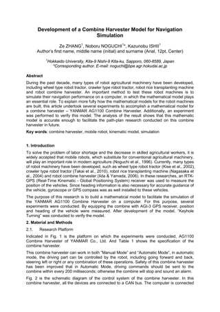
Indicated in Fig. 1 is the platform on which the experiments were conducted, AG1100
Combine Harvester of YANMAR Co., Ltd. And Table 1 shows the specification of the
combine harvester.
This combine harvester can work in both “Manual Mode” and “Automatic Mode”, in automatic
mode, the driving part can be controlled by the robot, including going forward and back,
steering left or right or any combination of these operations. Safety of this combine harvester
has been improved that in Automatic Mode, driving commands should be sent to the
combine within every 200 milliseconds; otherwise the combine will stop and sound an alarm.
Fig. 2 is the schematic diagram of the control system of the combine harvester. In this
combine harvester, all the devices are connected to a CAN bus. The computer is connected
2. to the CAN bus by a communication card, and the GPS receiver is connected to the CAN
bus by an ECU. The combine harvester can be controlled by the computer by sending
messages to the CAN bus. After receiving CAN messages, the combine harvester can drive
and/or work.
FIGURE 1: Experiment Platform YANMAR AG1100
TABLE 1: This an example of table
Length (mm) 6150
Width (mm) 2350
Height (mm) 2760
Engine Output (kW) 80.9
Crawler Size (mm) 500x1780
Speed (m/s) Low: 0~1.0
Medium: 0~2.0
High: 0~2.81
FIGURE 2: Schematic Diagram of Control System
2.2. Navigation Sensors
As briefed in the first part of this article, the navigation sensor used in this experiment was
AGI-3 GPS receiver produced by Topcon Co., Ltd (Fig. 3). This GPS receiver also consists
of an inertial sensor, which can provide heading information of the vehicle. By using RTK-
GPS mode, this GPS receiver is able to achieve an accuracy of +/- 2 centimeters.
3. Another advantage of this GPS receiver is that both GPS data and heading data are output
by a serial cable and it is simple to use.
FIGURE 3: AGI-3 GPS Receiver by Topcon Co., Ltd
2.3. Modeling
In order to develop mathematical model for the combine harvester, it is crucial to find out the
relationship among linear velocity, angular velocity, lever angle and steering angle.
According to the feature of crawler type vehicle, the relation among lever angle, steering
angle and speed difference of the two crawlers was measured and is indicated in Fig. 4.
FIGURE 4: Relation between Lever/Steering Angle and Crawler Speed Difference
In addition, when steering angle equals zero, the speed of crawler was measured (Fig. 5).
FIGURE 5: Relation between Lever Angle and Crawler Speed
4. Furthermore, the relation between steering angle and turning radius was also measured, as
in Fig. 6.
FIGURE 6: Relation between Steering Angle and Turning Radius
According to the data above, the linear velocity (v) and angular velocity (u) can be calculated
by lever angle (l) and steering angle (s) as in equation (1) ~ (2):
, (1)
, (2)
in which:
. (3)
2.4. Steering Controller
In terms of offset and heading error, the steering controller provides guidance information to
the combine harvester. As is in Fig. 7, Offset (d) of the vehicle is calculated by the two
closest points and heading error ( φ∆ ) is decided by φ and dφ .
FIGURE 7: Steering Controller
Finally, the steering angle is given by equation (4). And a1 and a2 are determined by
preliminary experiments
φδ ∆+= 21 ada (4)
5. 2.5. Experimental Method
Keyhole turning experiments were conducted in order to test the accuracy of the
mathematical model developed in this article. As in Fig.8, when the combine finishes one
path and the next path is on the left, it moves to point A and turns right to point B – point B is
decided by the heading angle of the combine. And it continues to turn left until it reaches
point C. Point C is where the heading is 170 degrees compared to that of Point A. Finally
from point C to point D, the path is generated by spline function. In this experiment, the path
between point A and point C was tested.
FIGURE 8: Keyhole Turning
3. Results and Discussions
Two real tests were conducted and the results are in Fig.8. The red line is the trajectory of
the first test and the green line is the trajectory of the second test. On the other hand, the
blue line is the result of simulation.
FIGURE 8: Results Comparison
6. 4. Conclusions
In this study, a mathematical model for YANMAR AG1100 combine harvest was developed.
To test the accuracy of the model, the AGI-3 GPS was used to measure the location and
heading of the vehicle. The keyhole turning tests were conducted and the results showed
that the accuracy of the model was high.
For future work, the model will be used in combine harvester path plan simulation and to
generate a high efficiency path for the combine harvester.
References:
Iida, M., Yamada, Y., (2006). Rice harvesting operation using an autonomous combine with a
GPS and a FOG, Proceedings of the Conference of Automation Technology for Off-road
Eqipment 2006, ASAE, 125-131.
Nagasaka, Y., Umeda, N., Kanetani, Y., Taniwaki, K., Sasaki, Y., (2004). Autonomous
guidance for rice transplanting using global positioning and gyroscopes, Computers and
Electronics in Agriculture, 43, 223-234.
Noguchi, N., Ishii, K., Terao, H., (1996). Development of an Agricultural Mobile Robot using a
Geomagnetic Direction Sensor and Image Sensors, Journal of Agricultural Engineering
Research, (1997)67, 1-15.
Kise, M., Noguchi, N., Ishii, K., Terao, H., (2002). Field mobile robot navigated by RTK-GPS
and FOG (Part3), Journal of JSAM, 64(2), 102-110.
Takai, R., Barawid, O. Jr., Ishii , K., Noguchi, N., (2010). Development of Crawler-Type
Robot Tractor based on GPS and IMU, Preprint of the IFAC International Conference on
AGRICONTROL 2010 (CD-R), A3-5.