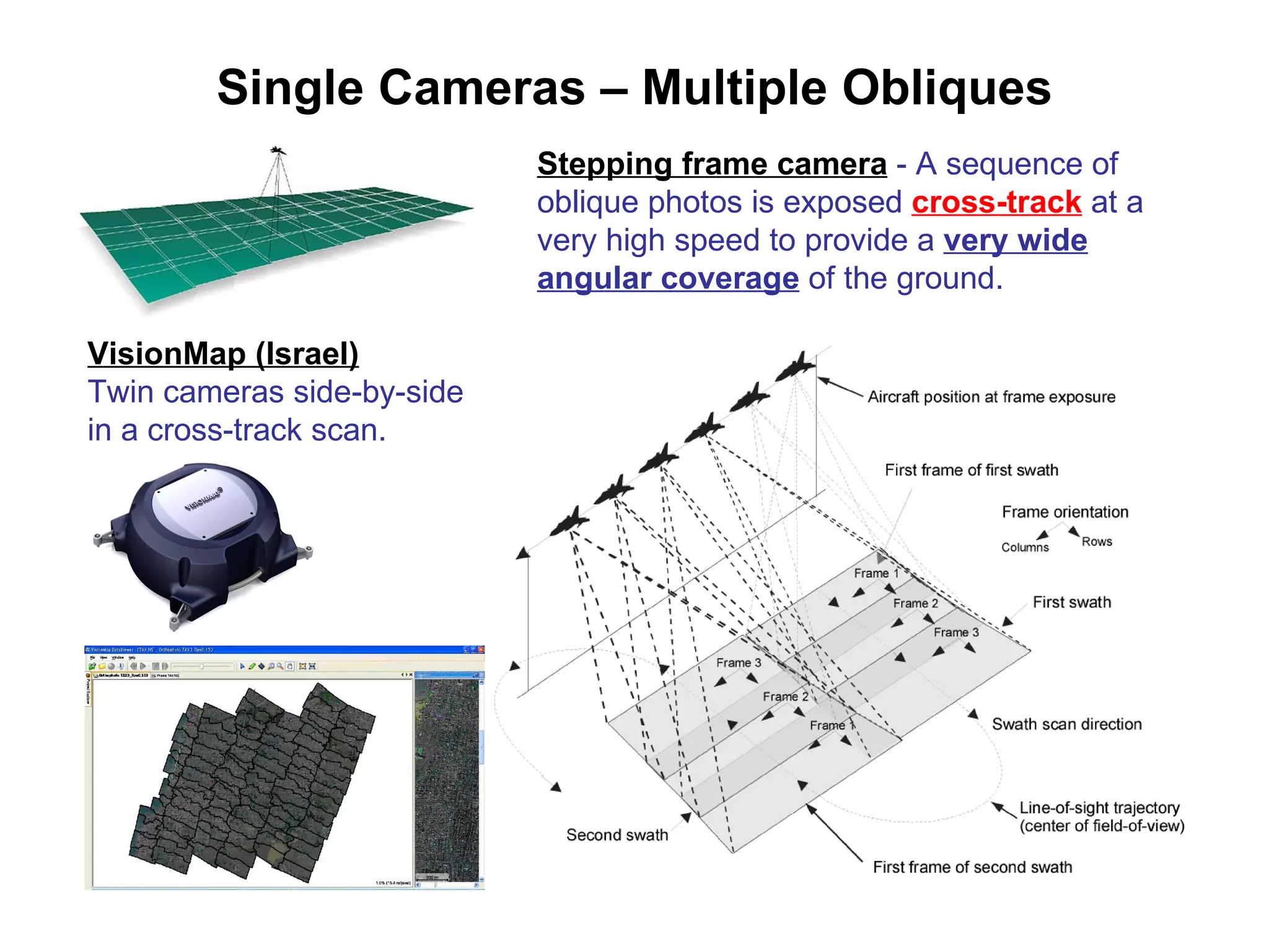
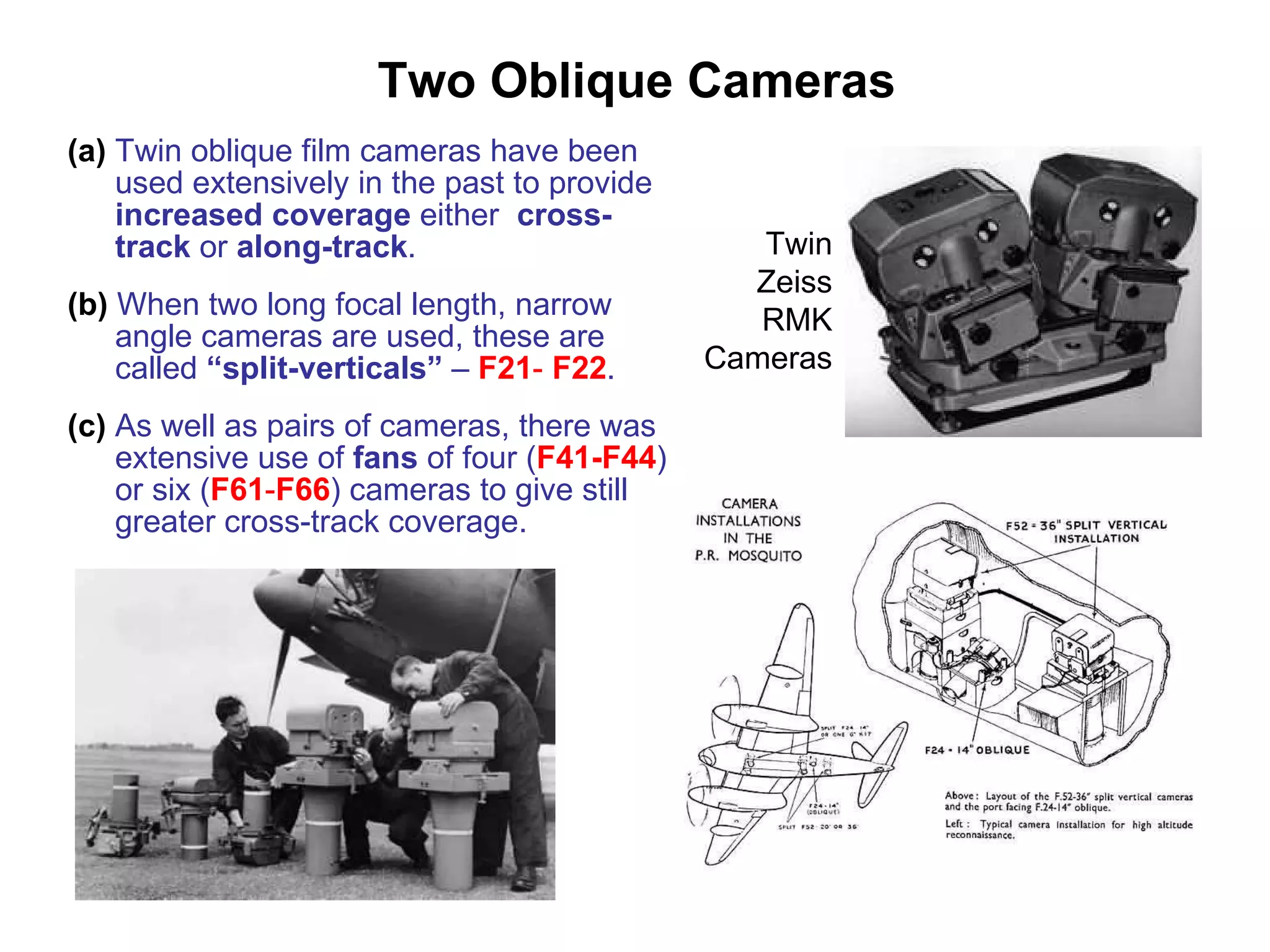
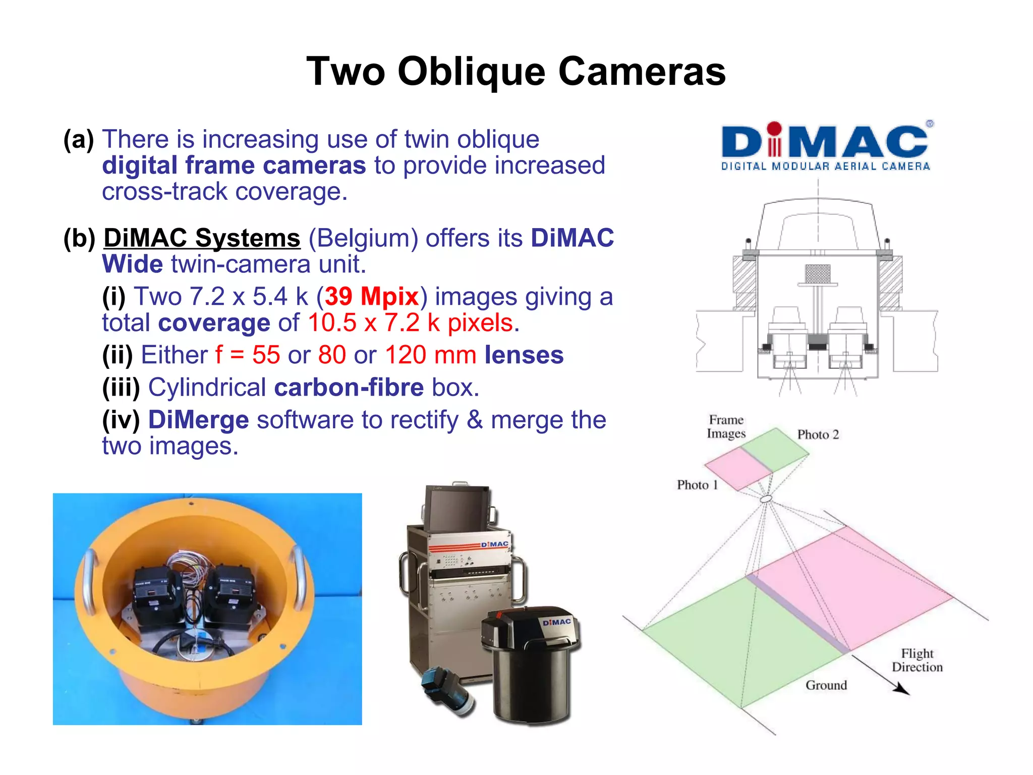
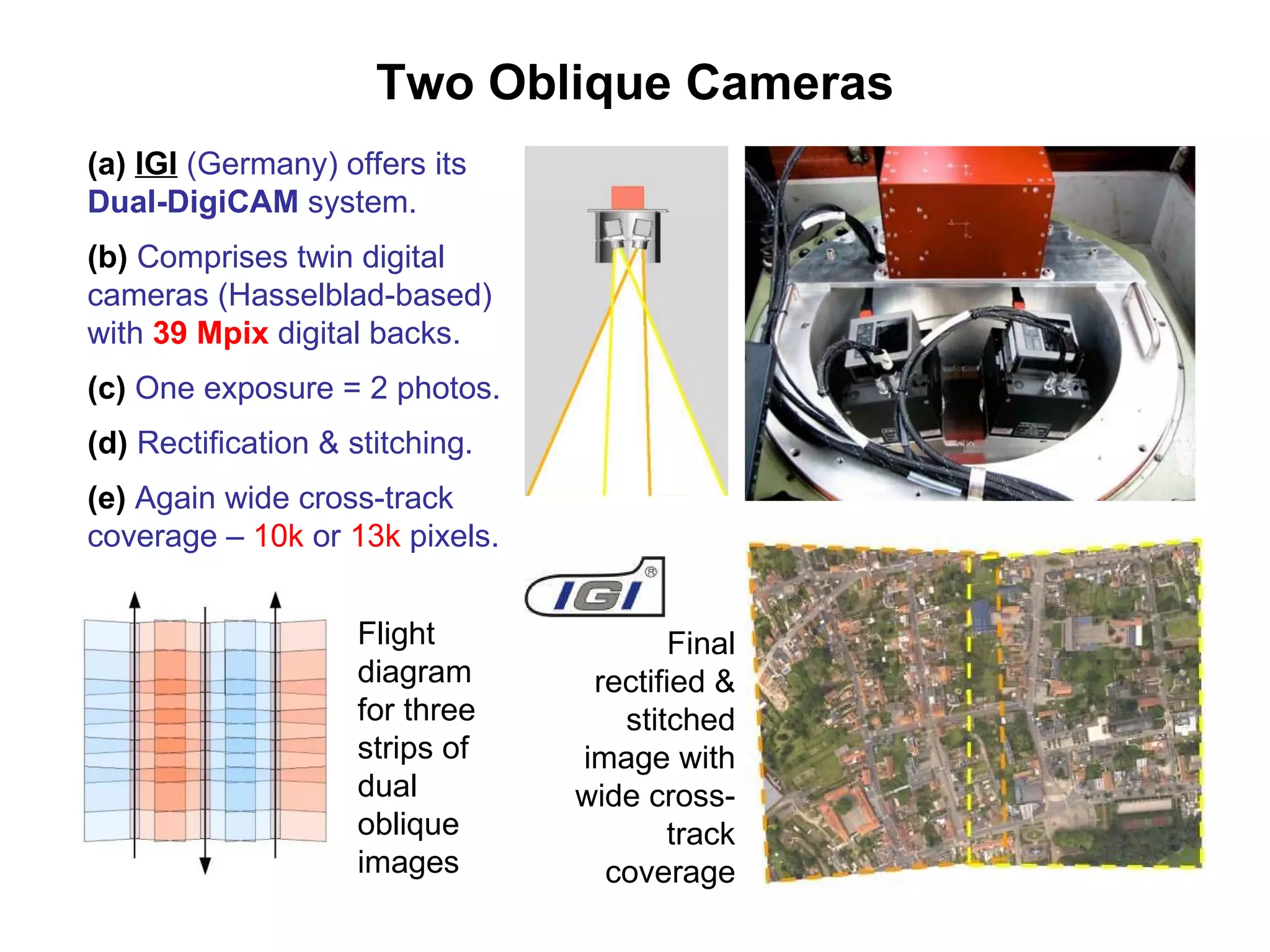
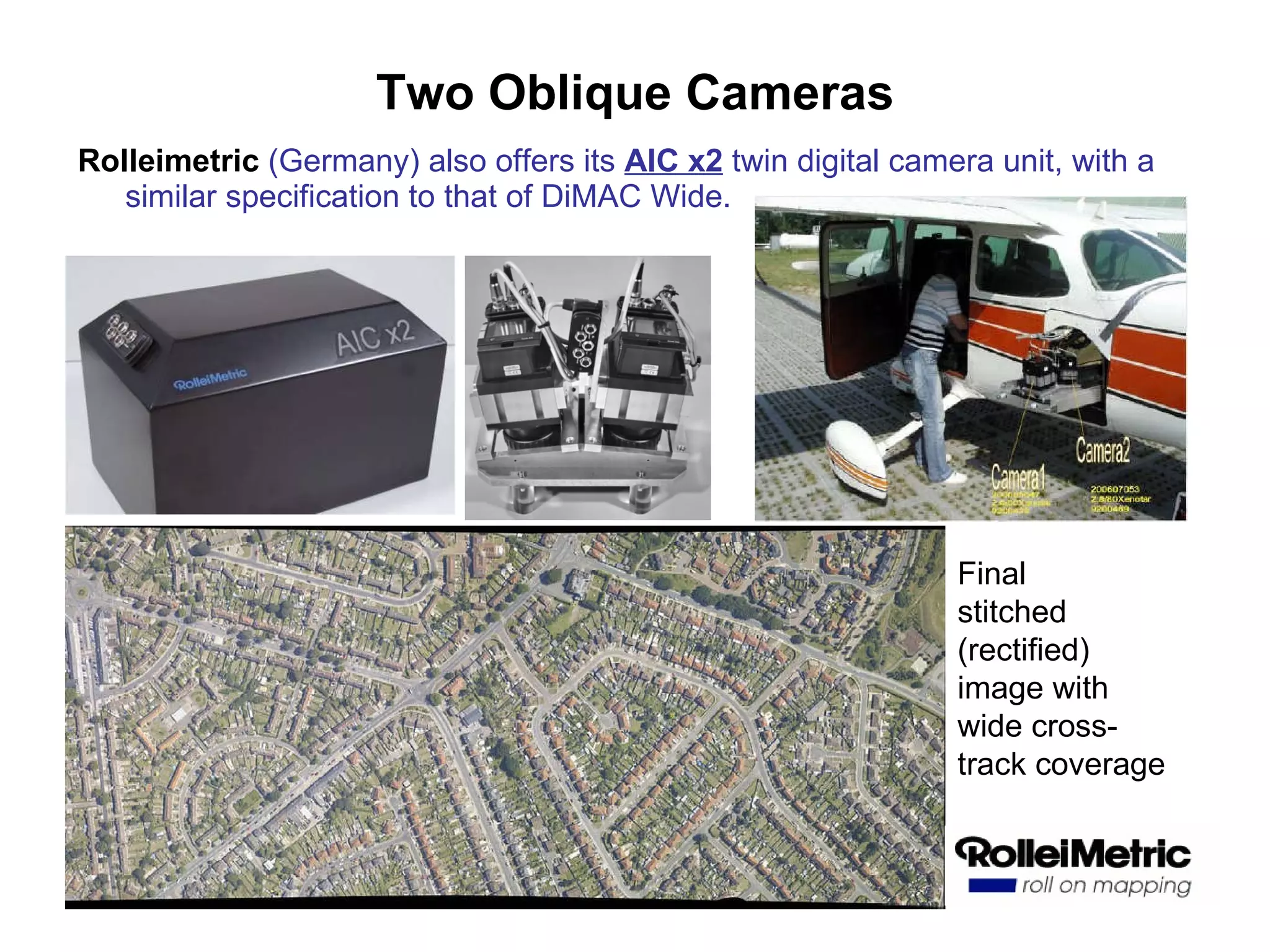
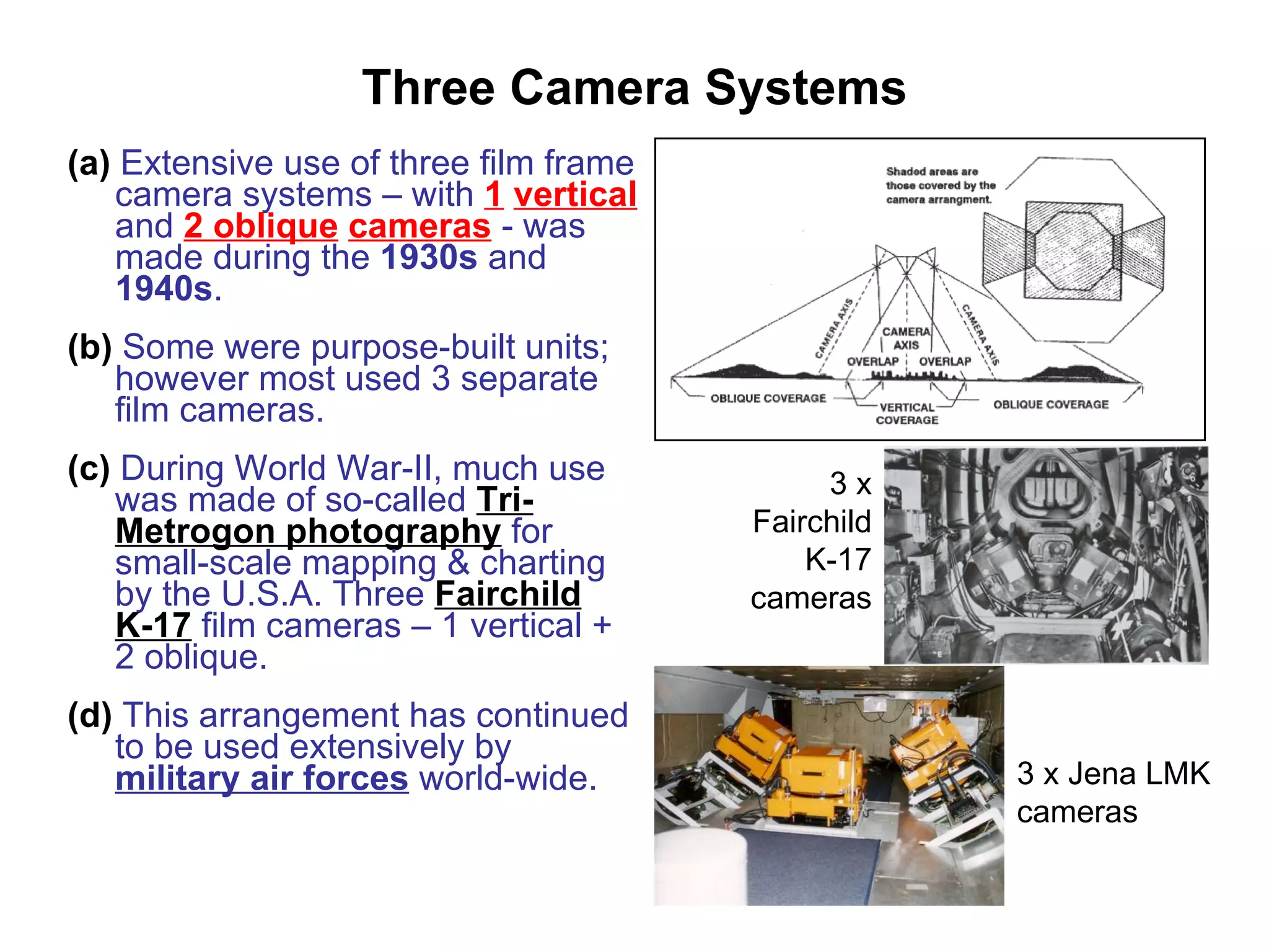
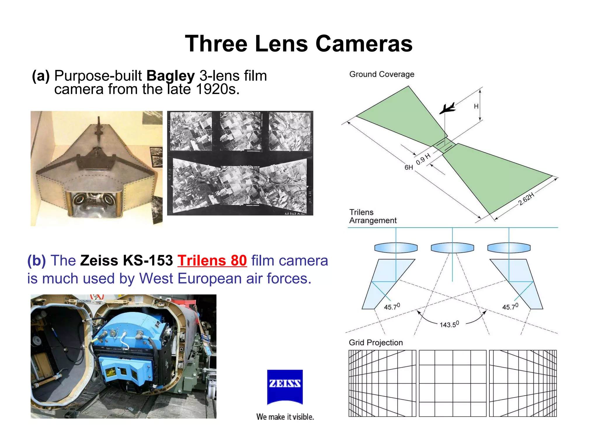
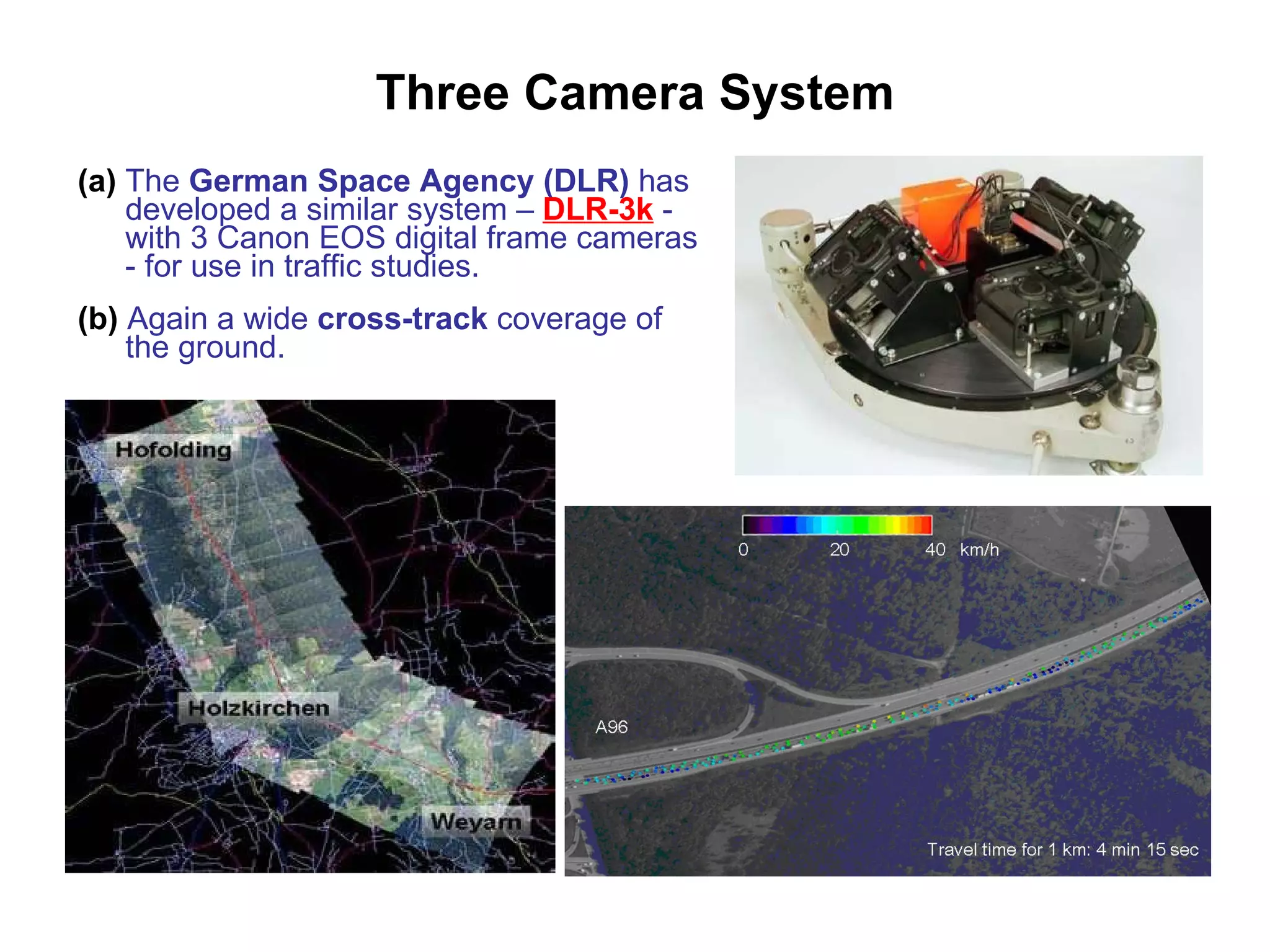
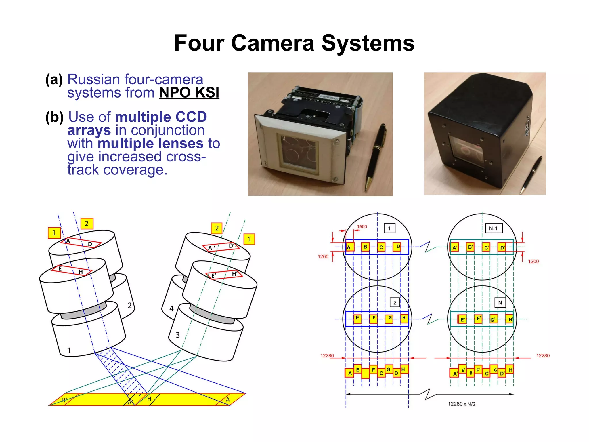
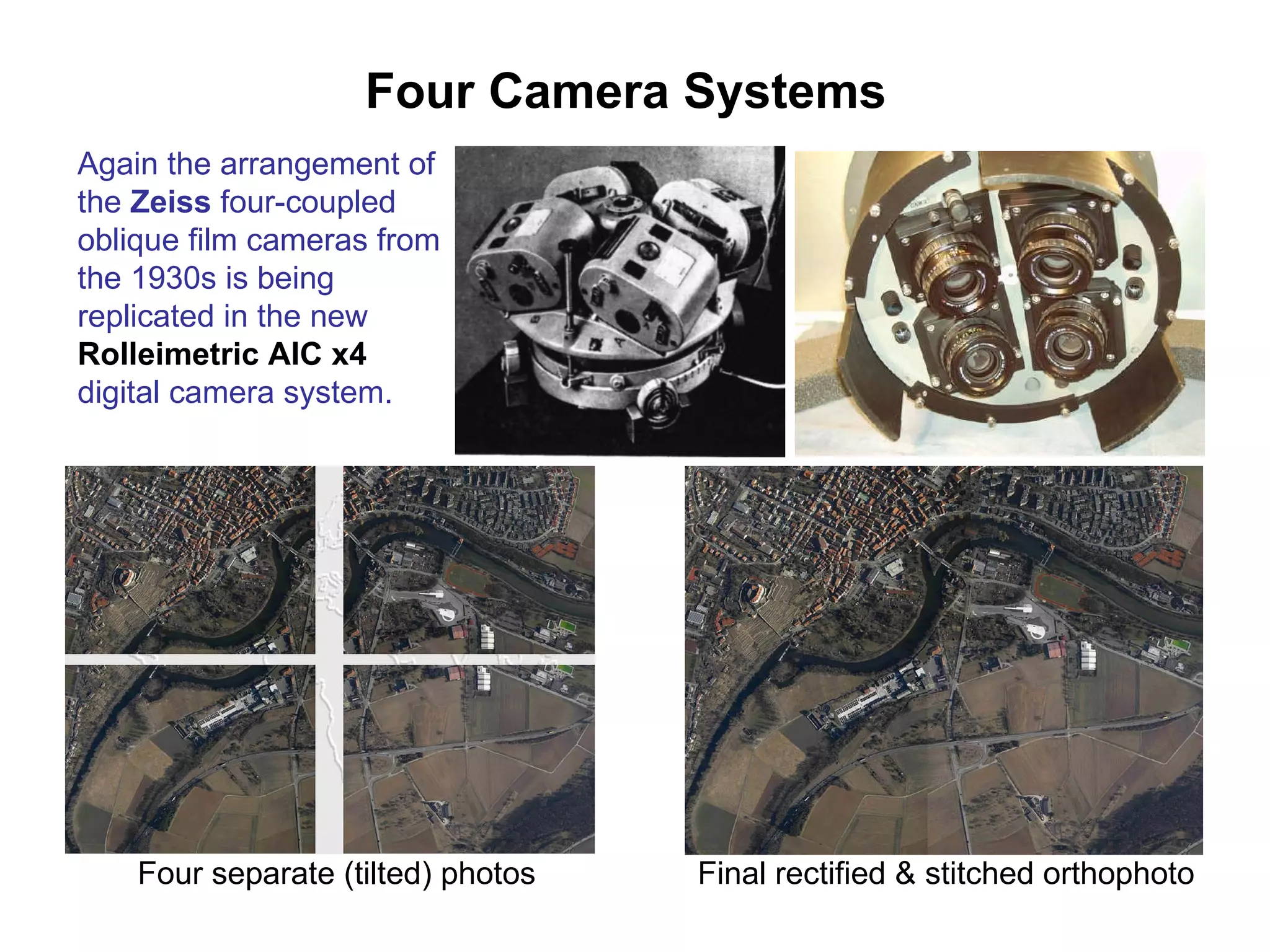
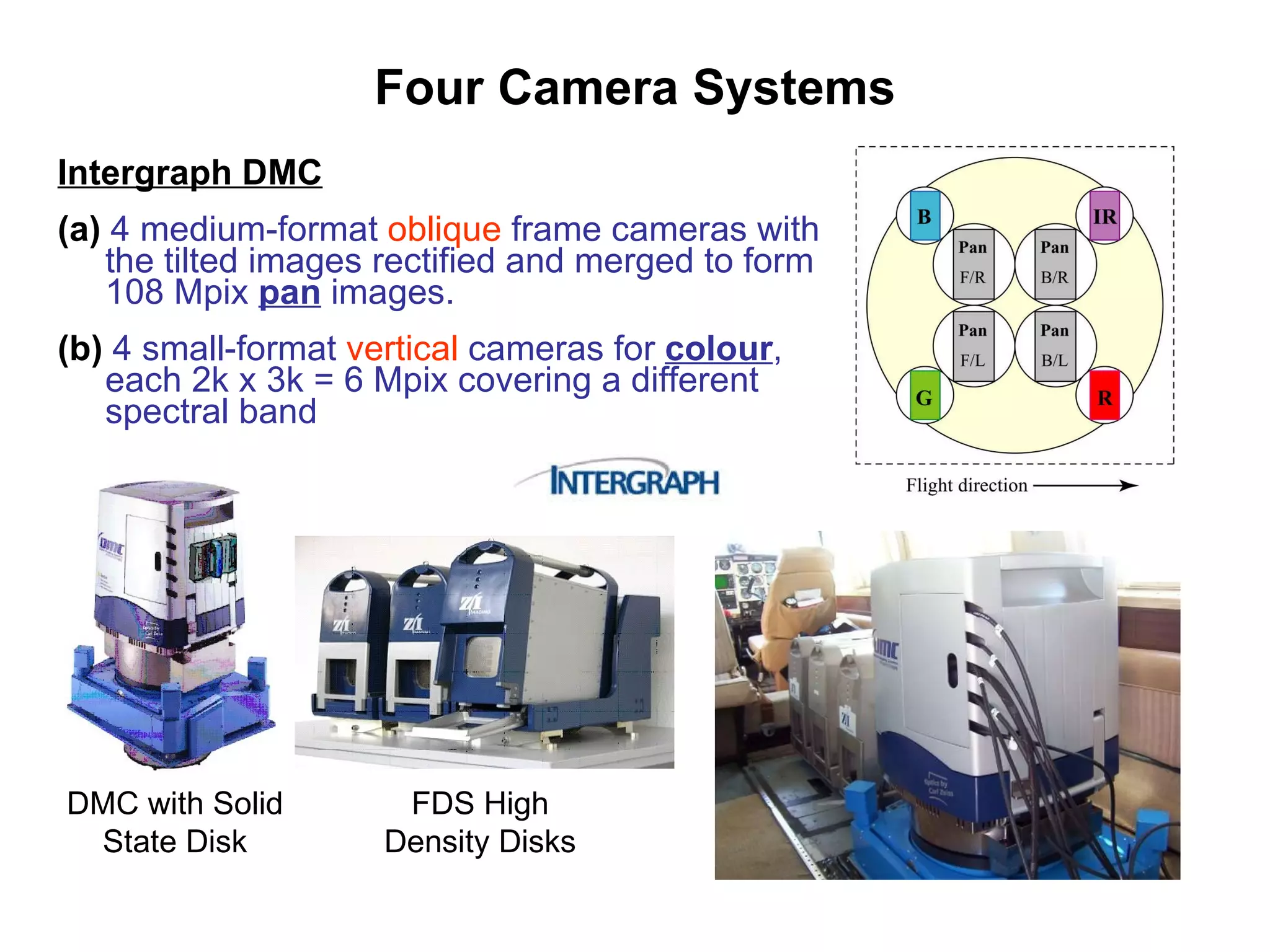
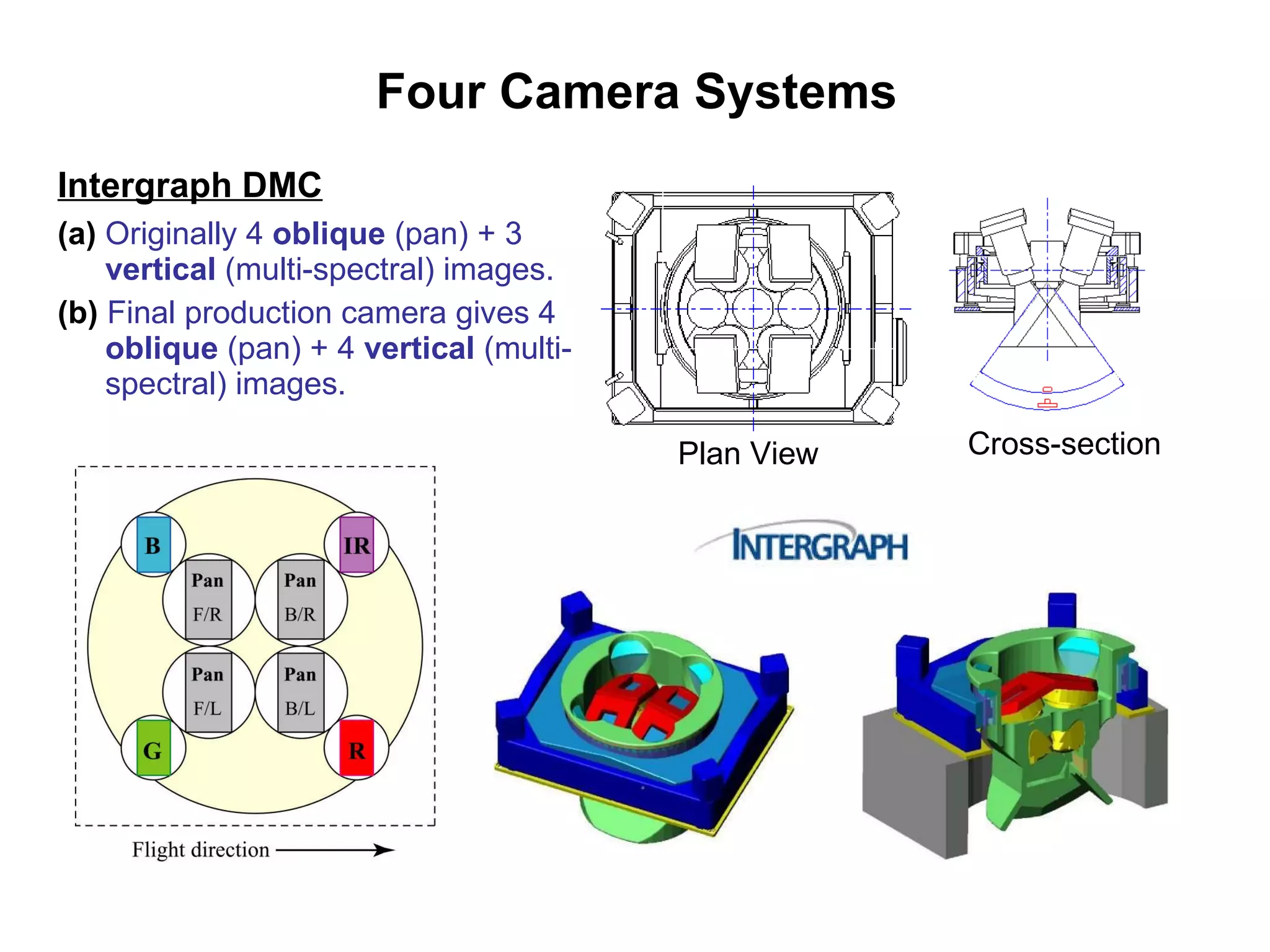
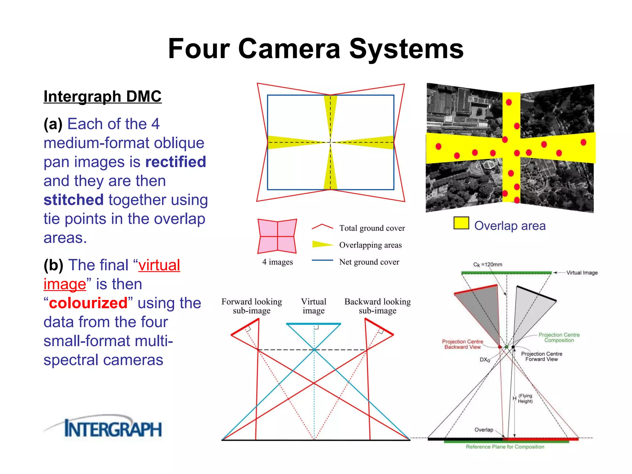
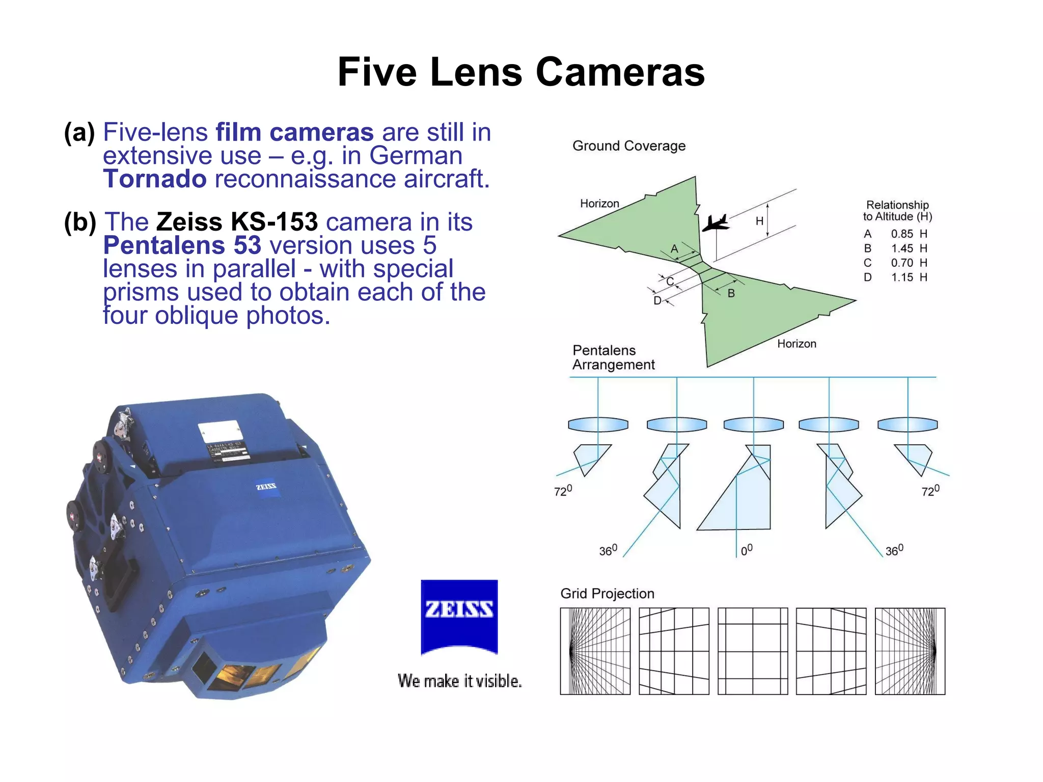
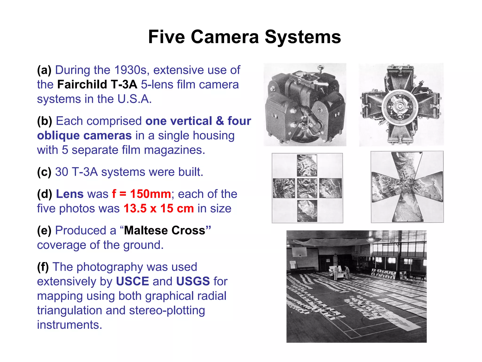
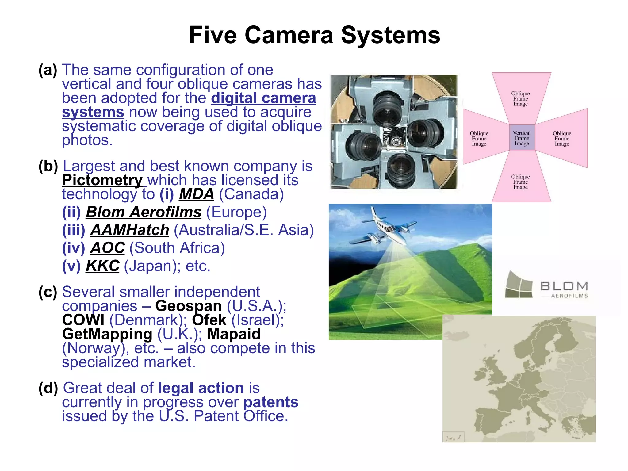
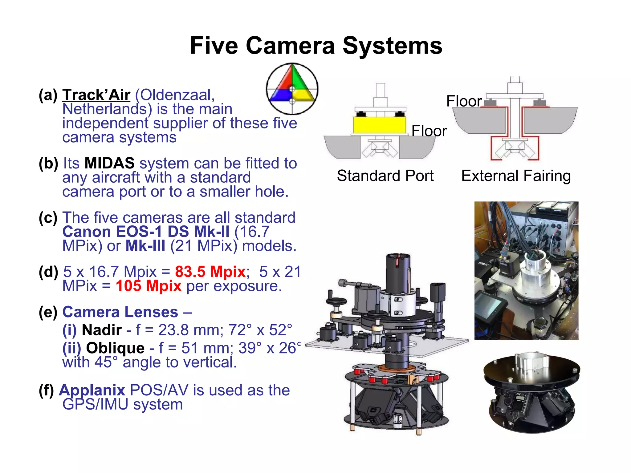
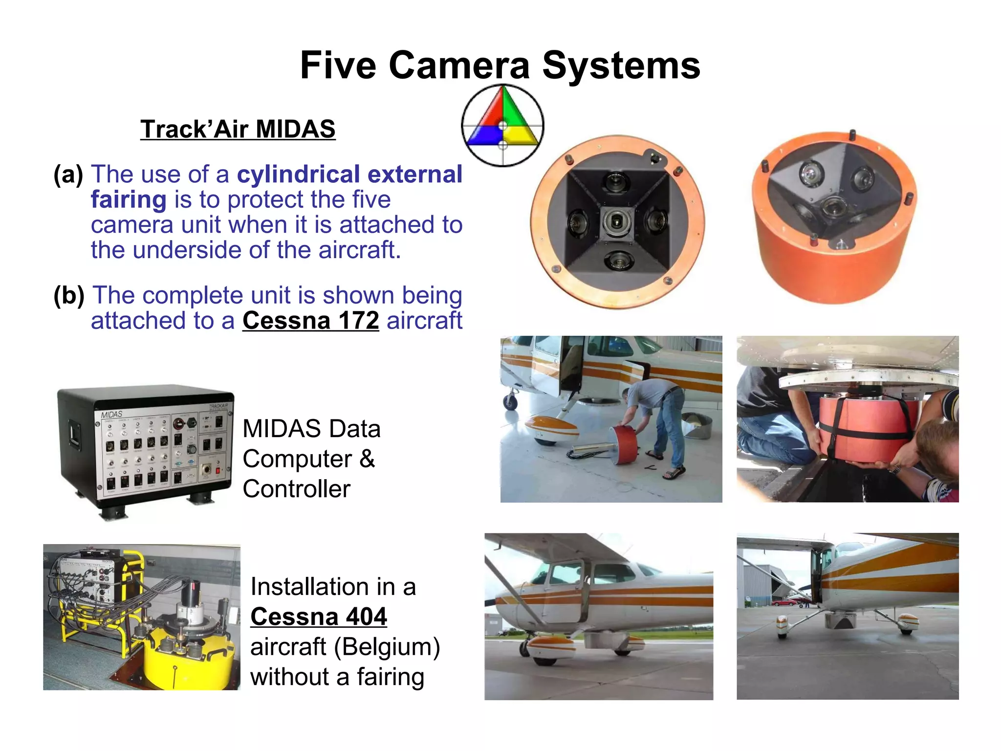
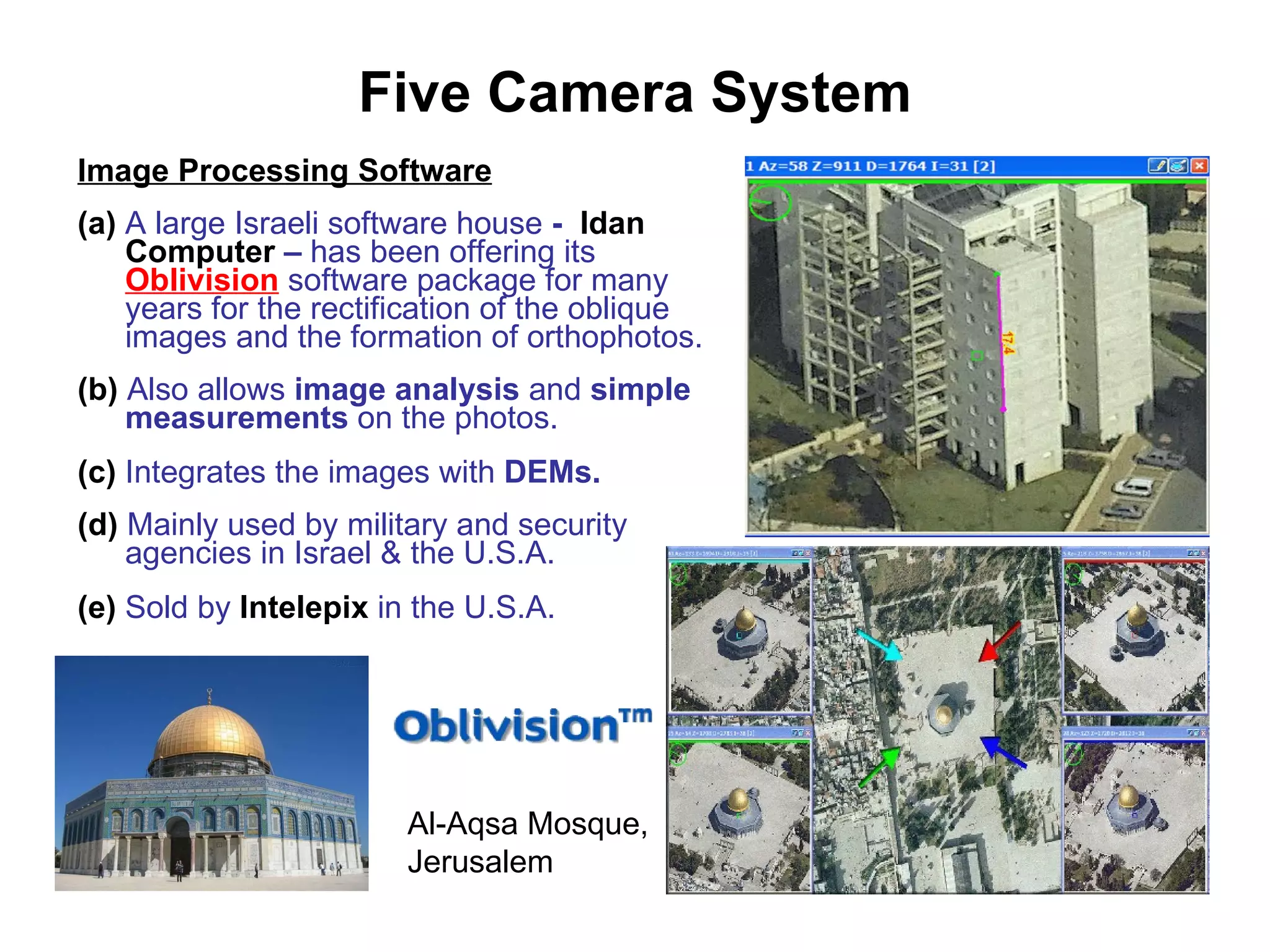
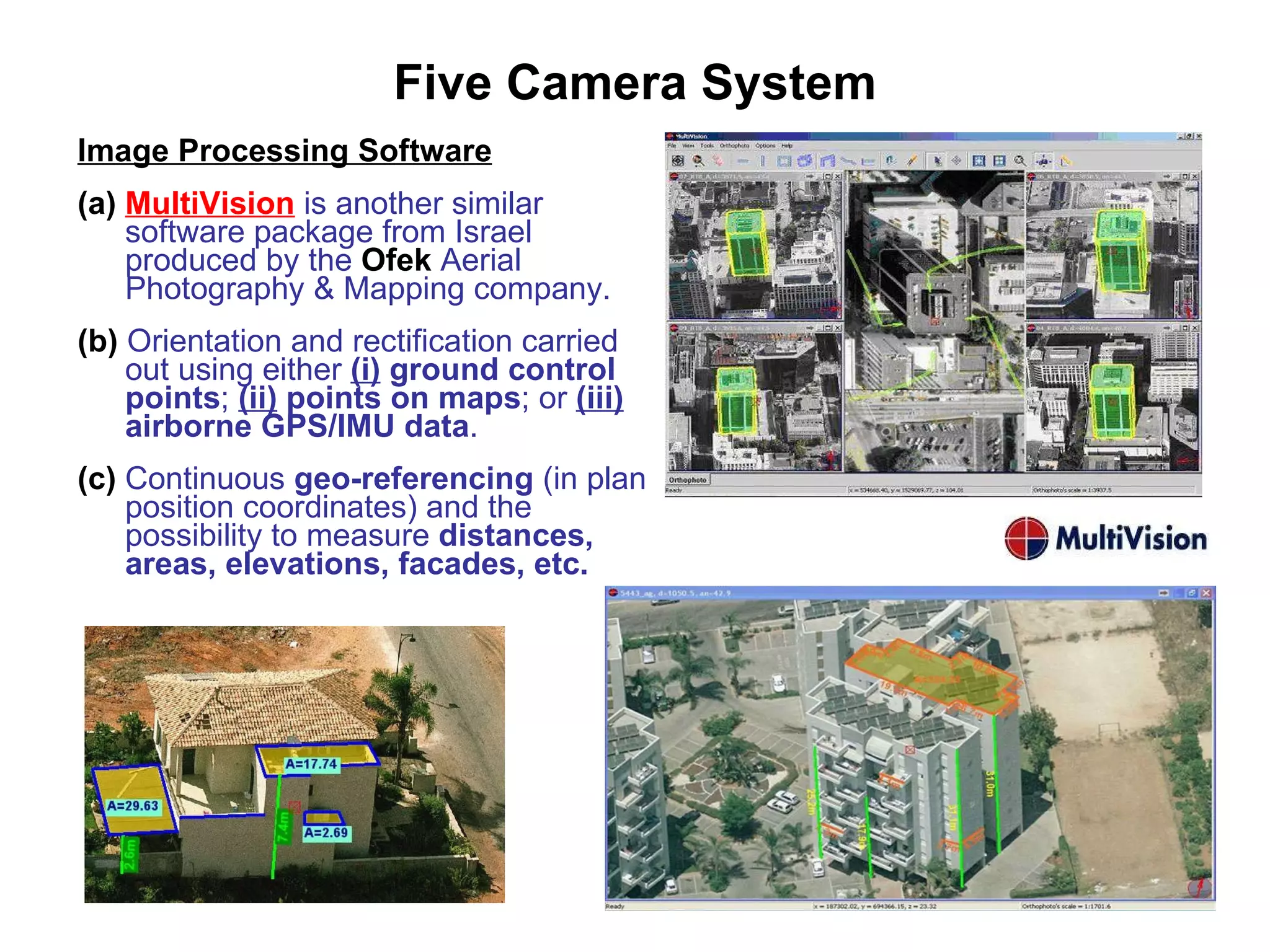
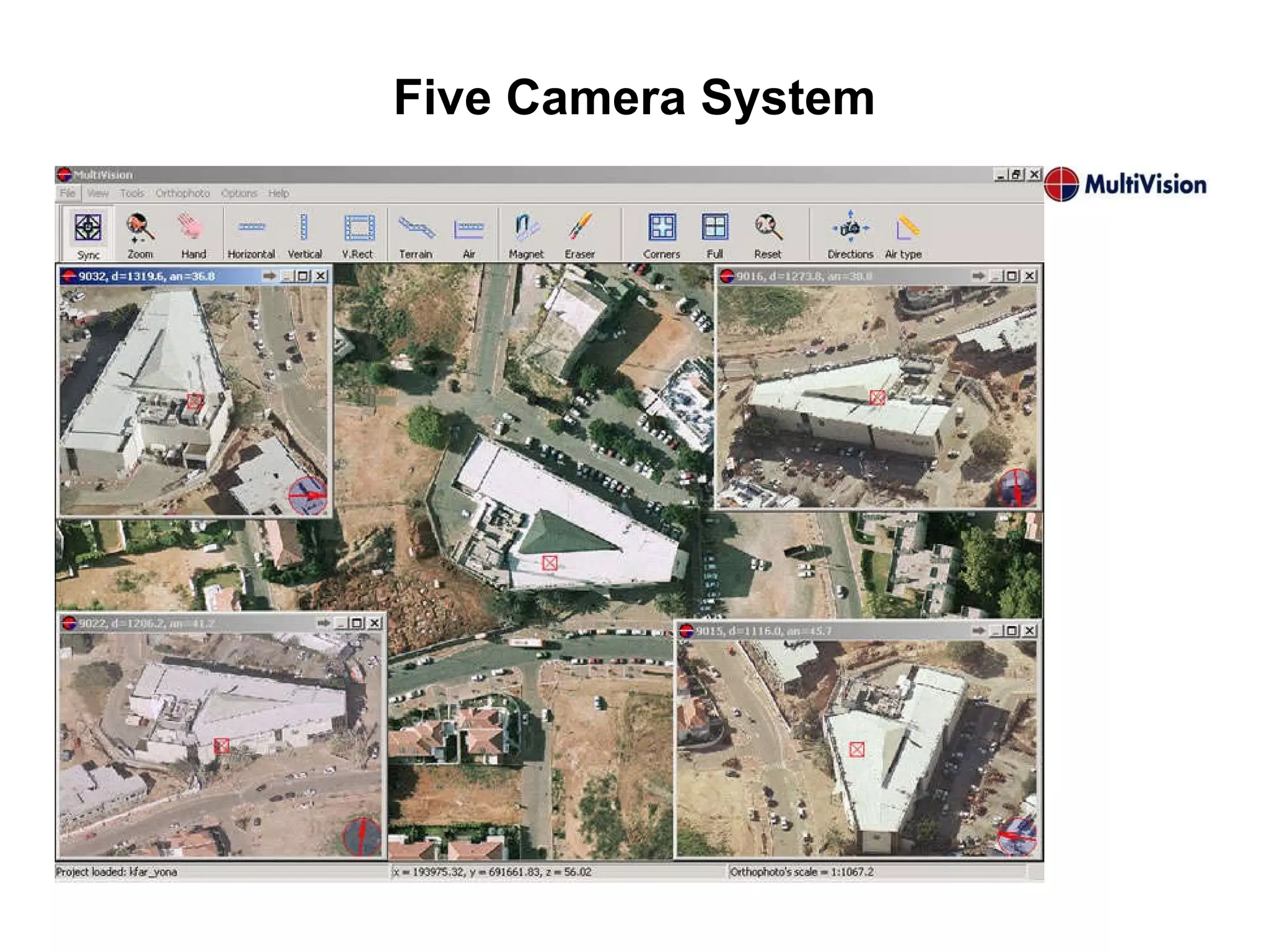
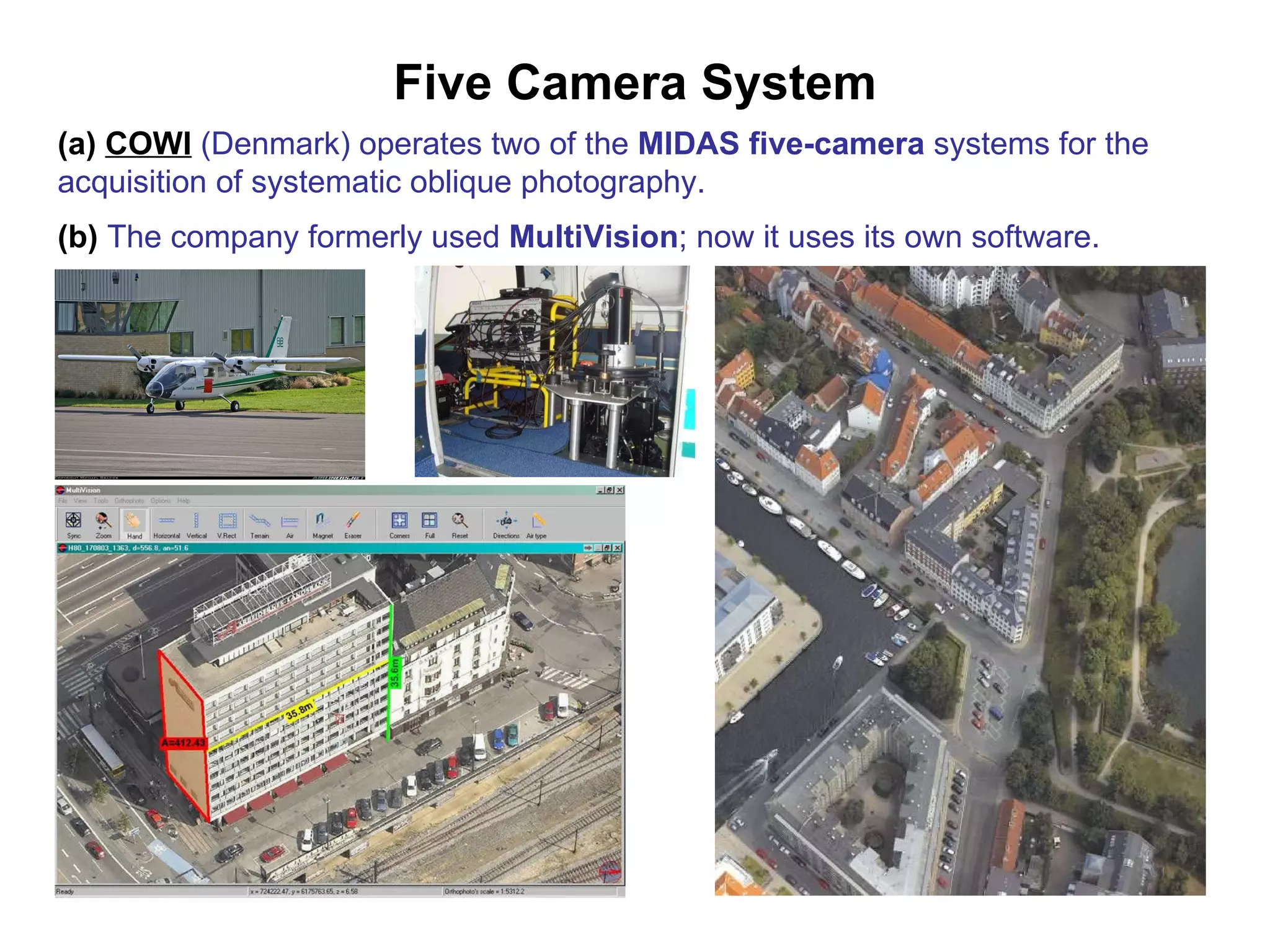
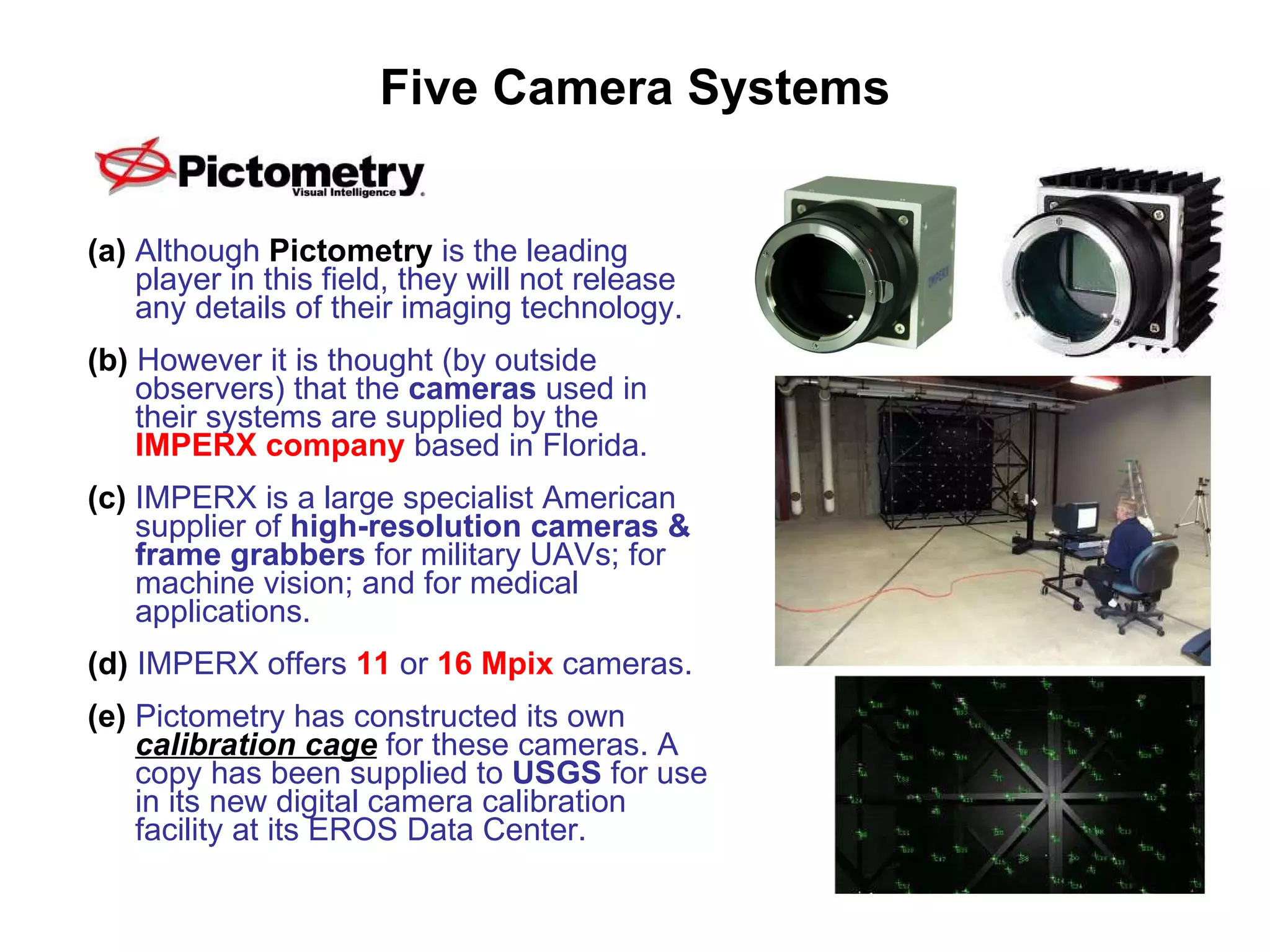
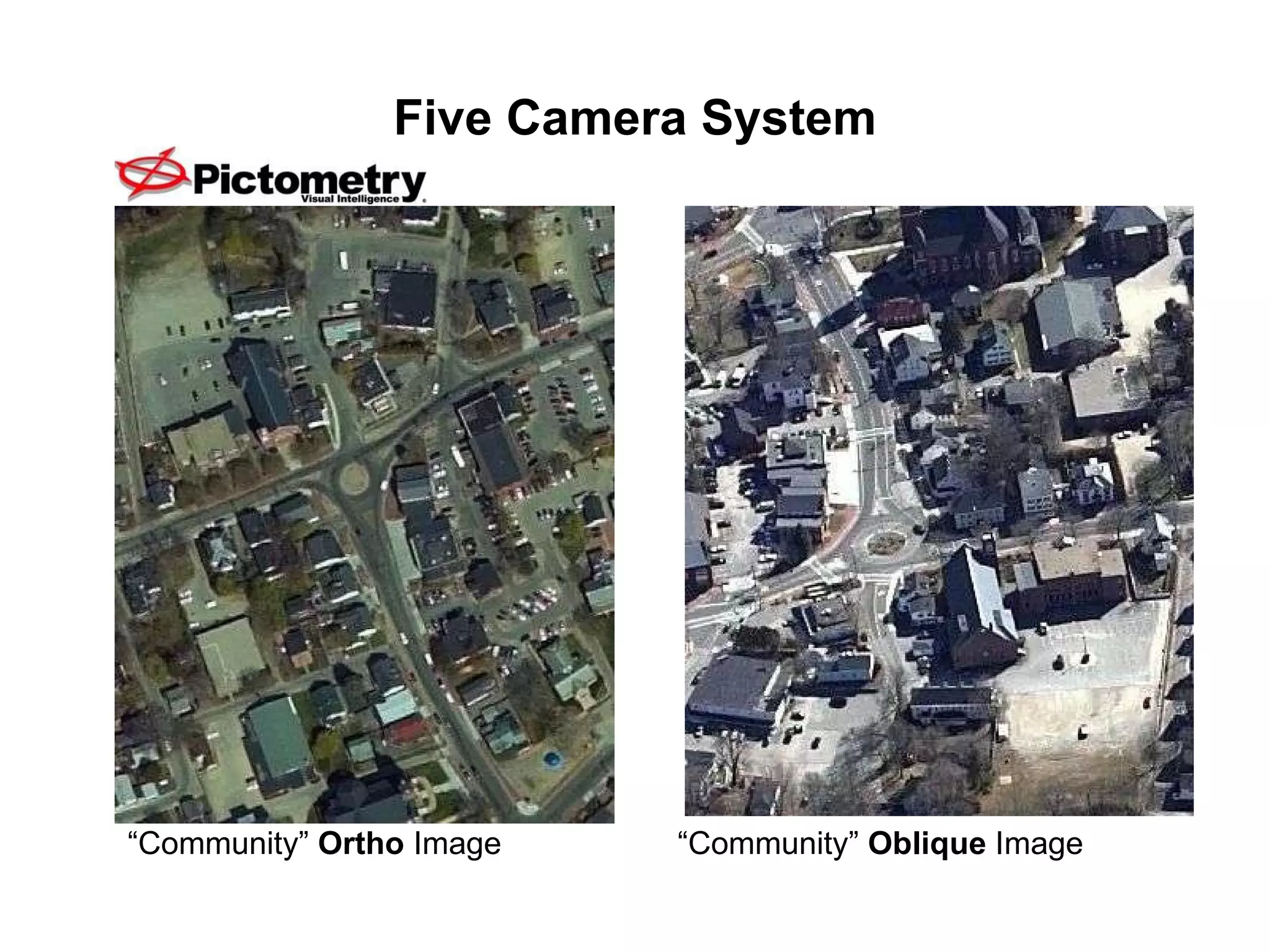
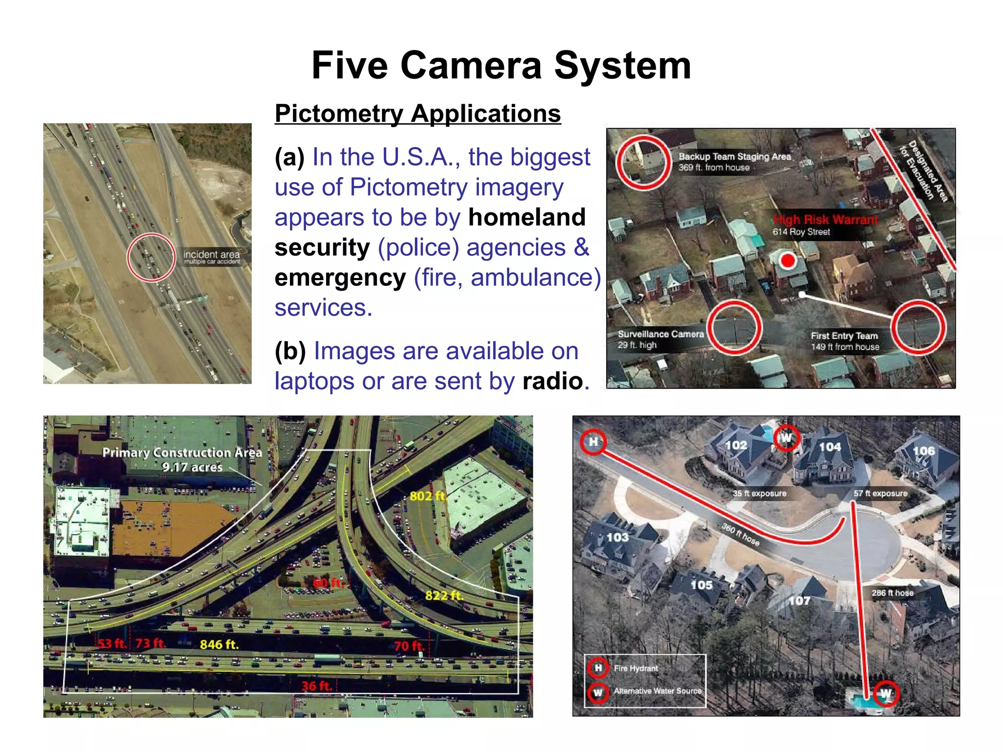
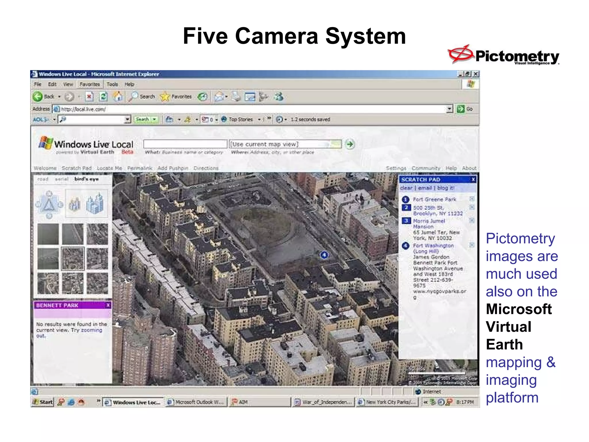
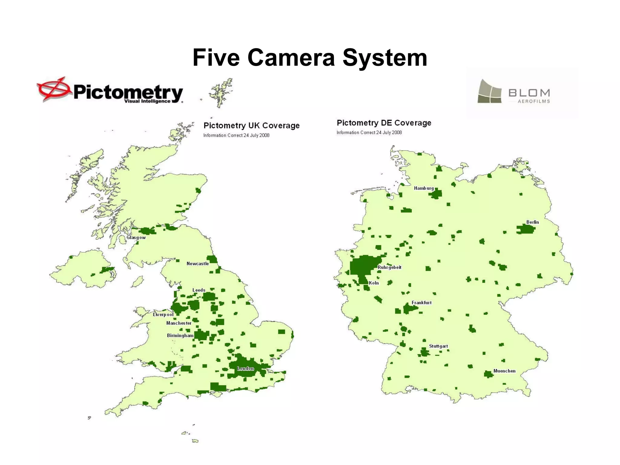
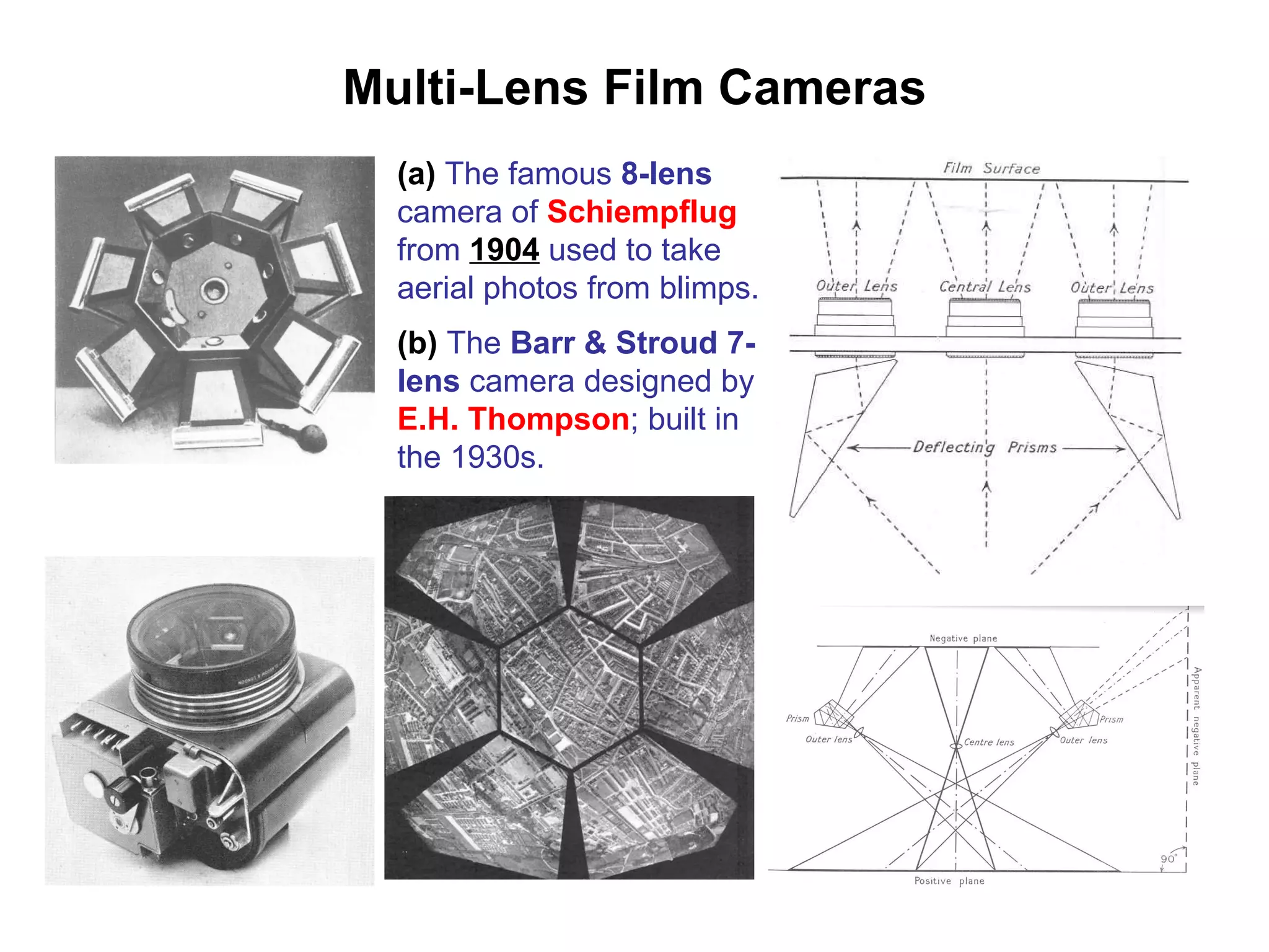
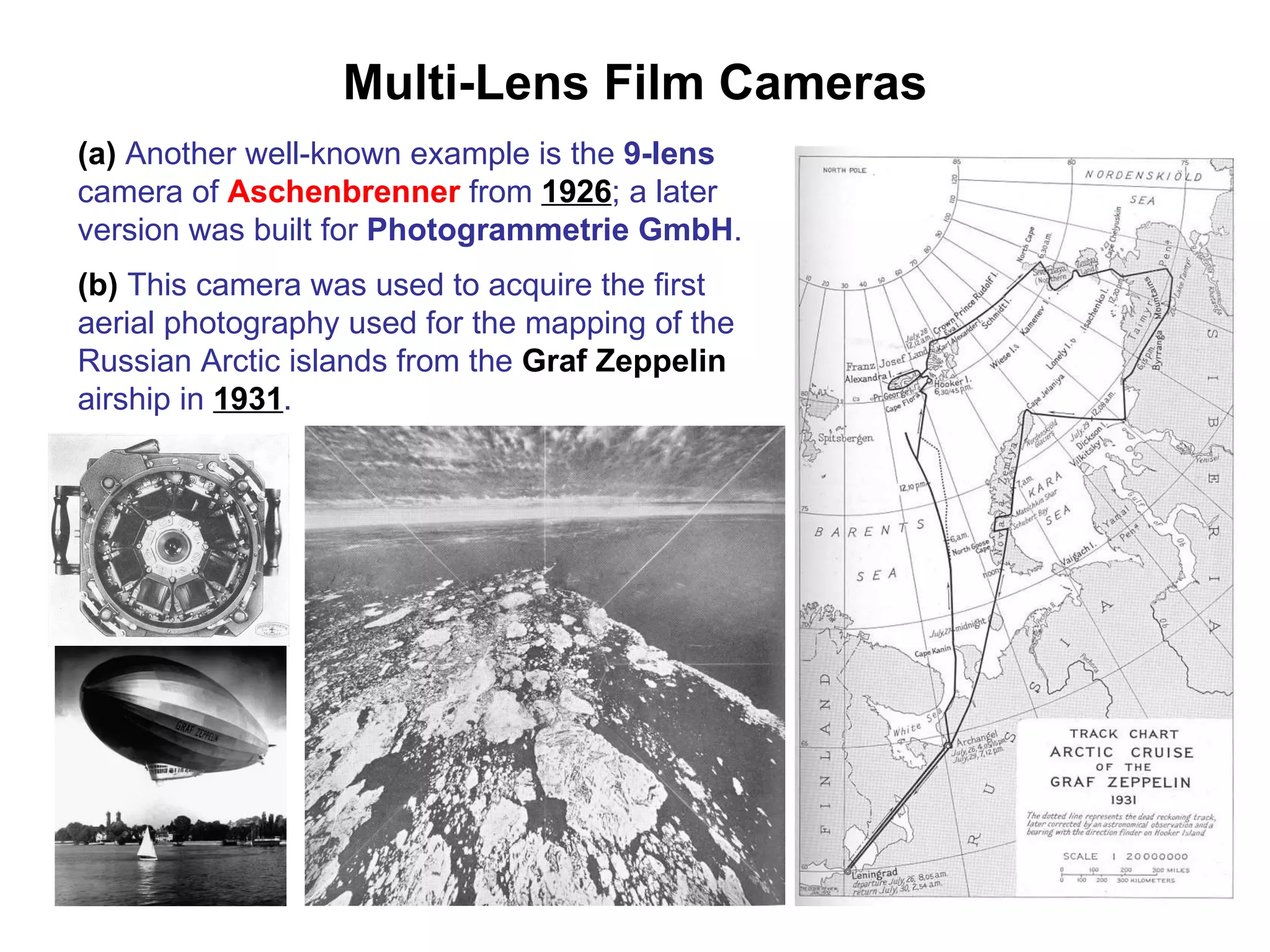
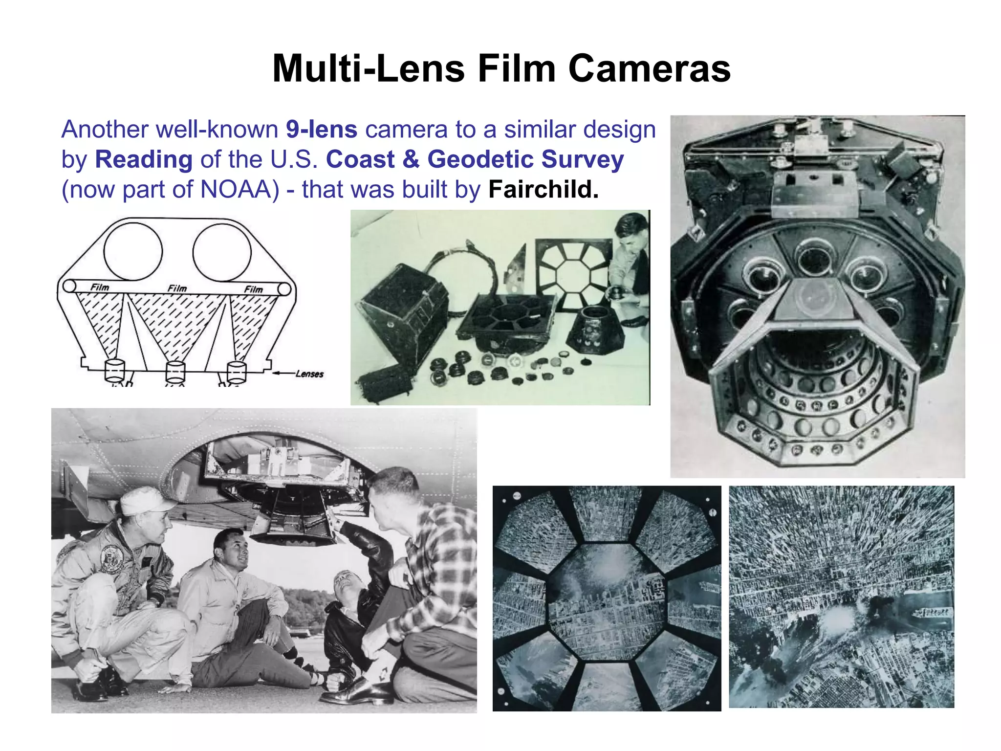
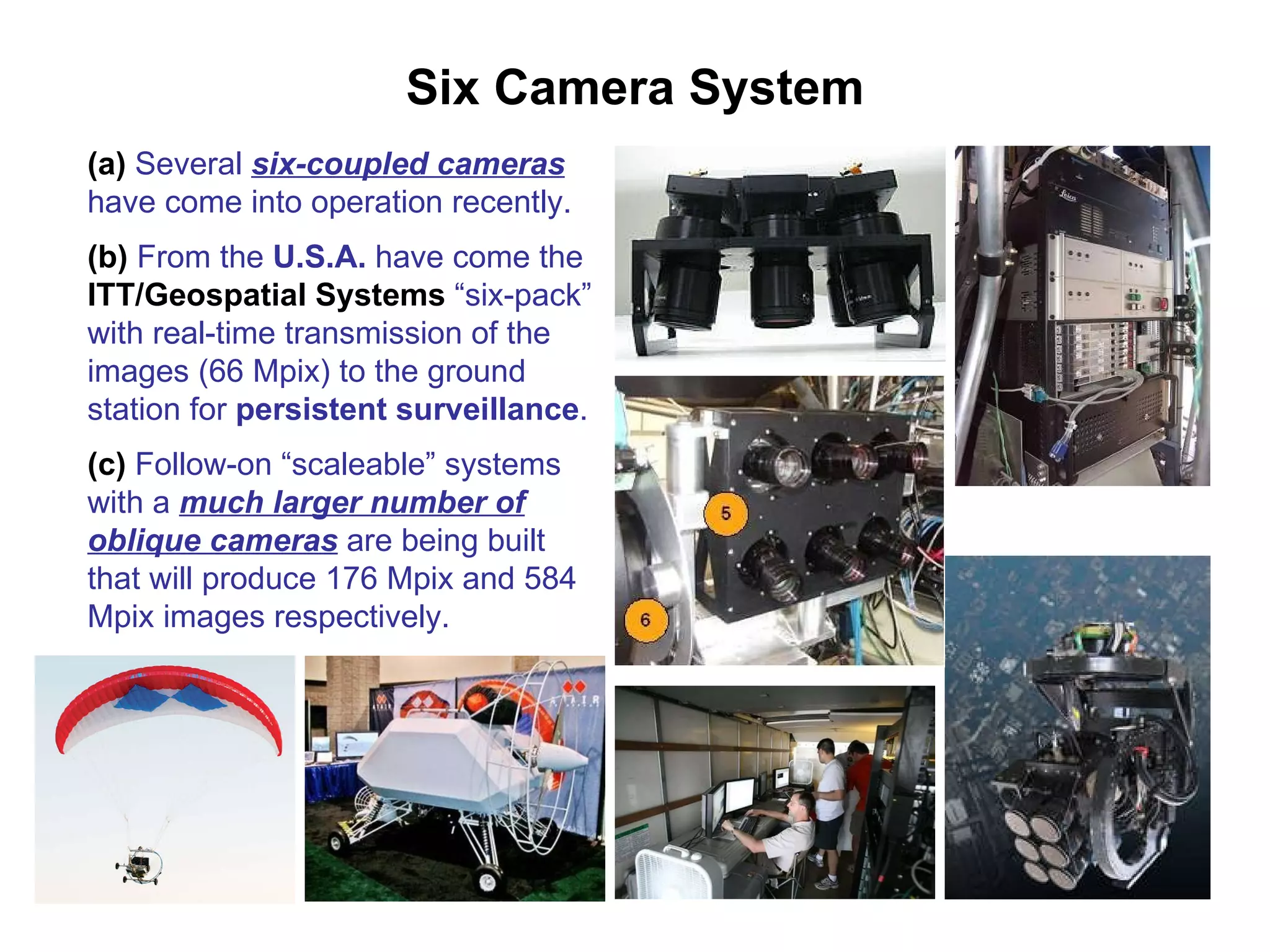
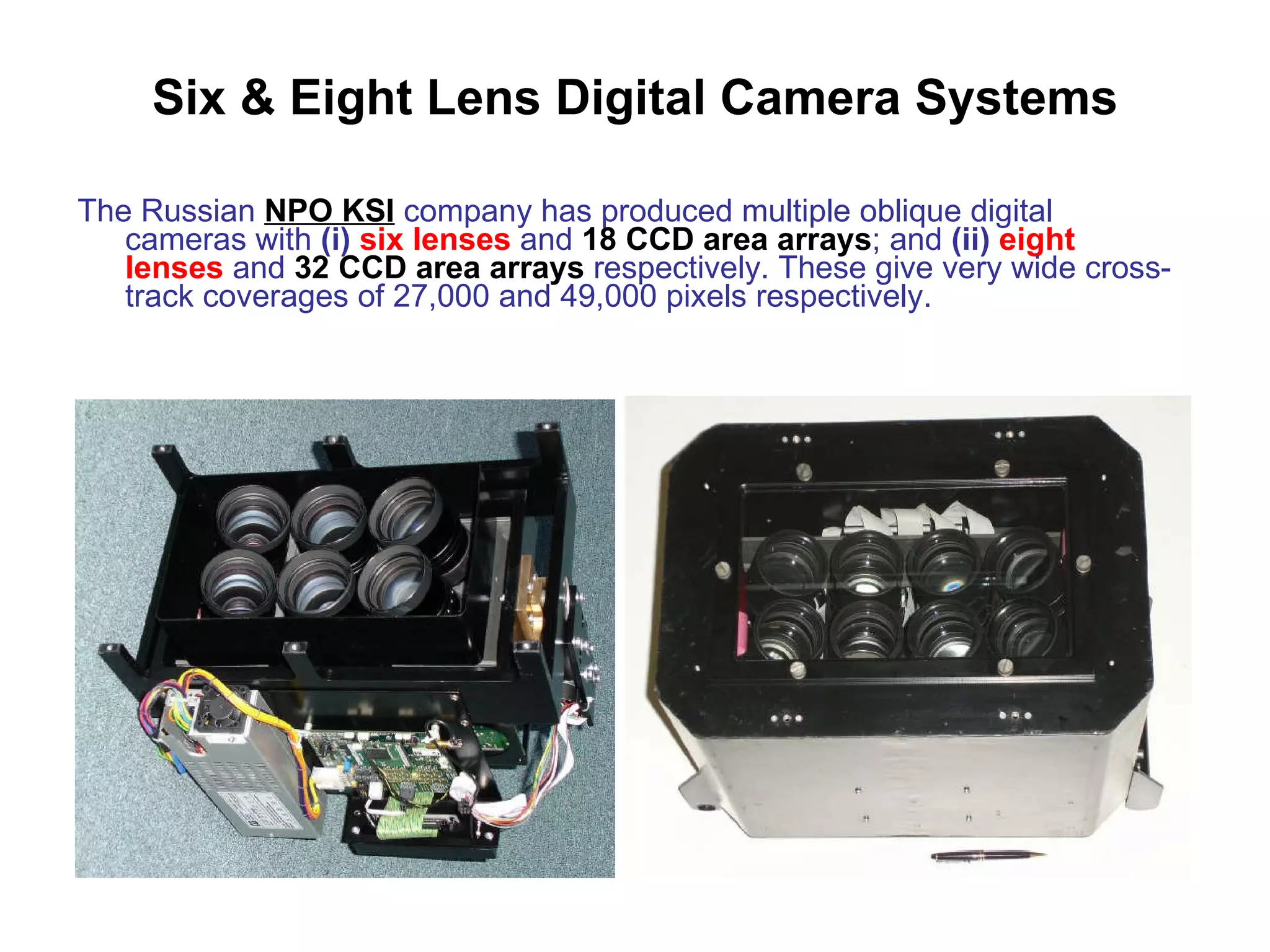
Systematic Oblique Aerial Photography Using Multiple Digital Cameras   by Prof. Gordon Petrie  (Univ. of Glasgow ) VIII International Scientific & Technical Conference “ From Imagery to Map: Digital Photogrammetric Technologies” September 15-18, 2008 – Porec, Croatia
Oblique Photography - Introduction I - Multiple Oblique Photographs (a)   Currently much interest in oblique photography - partly triggered by the high-profile activities of  Pictometry  and its licensees and competitors. (b)   This has involved the   systematic coverage of urban areas  using multiple oblique aerial cameras. Huge numbers of photographs are being generated – Pictometry operate 70 aircraft in the U.S.A.; Blom 13 aircraft in Europe ; and so on. (c)   In its report on the ISPRS 2008 Congress ,  our hosts,   Racurs,  wrote  (i)   “There is a strong movement towards combining traditional  nadir   images  with  oblique images  acquired at high angles to build  3D models  of cities with the texture of building walls taken from the oblique photos”. (ii)   “For non-specialists in the  emergency services  (military, police, fire, ambulance), the combination of oblique and nadir images improves their  interpretation   while special software allows  simple measurements  on the oblique photos”.
II - Multiple Oblique Cameras (a)   Lohman   (Univ. of Hannover) – speaking in more general terms about technical developments, talks of a  “re-birth”  of multiple oblique camera systems – alluding to their extensive prior use during the period 1920 -1945 for mapping & reconnaissance purposes. (b)   Part of the current interest in multiple oblique camera configurations stems from the limitations in the size of current CCD & CMOS area arrays for digital cameras – hence the use of  multiple oblique cameras  by a number of system suppliers to  increase the ground area  that can be   covered from a single exposure station. (c)  Besides the increase in the coverage area of rectangular or square format digital frame photos, there is long-standing requirement on the part of military air forces   to obtain the widest possible  cross-track angular coverage  using  fans of oblique cameras  for reconnaissance purposes. Oblique Photography - Introduction
Oblique Photography - Introduction III - Surveillance from Unmanned Airborne Platforms (a )  Apart from the multi-photo & multi-camera aspects of oblique aerial photography, the oblique imaging configuration is also of increasing importance for both  surveillance  and for  visualization  purposes –  with the acquisition of both  single  and  multiple  digital images from both manned and unmanned platforms – often from  low altitudes . (b)  There are many new developments in oblique aerial photography using digital cameras operated through  radio links  on numerous types of  unmanned airborne platforms  from  low altitudes  :– (i)   robotic mini-helicopters ; (ii)   powered mini-airships ; (iii)   powered paragliders ; (iv)   tethered blimps ; and (v)   telescopic masts
Oblique Photography (Manned) (a)  Area of great activity in some countries – e.g. in  U.K.,  more than  60 companies  engaged in this field. (b)  Oblique photos used extensively for  visualization  by estate agents & property developers; for  monitoring progress  on projects (for payments) by civil engineers and builders. (c)  Oblique frame photos are  commissioned  specifically for a particular site or property or area on contract – not for stock. (d)  Mostly  Cessna 172  aircraft are used – widely available; very cheap to operate -  £200  per hour. (e)  Some limited use of  helicopters , but very high cost to operate –  £800  per hour.
Oblique Photography (Unmanned) (a)  The acquisition of oblique aerial photography by  unmanned means  is an area of strong development. (b)  The use of  radio-controlled mini-helicopters  is now becoming common – circa  10 commercial companies  in this field in U.K.. (i)  Mini-helicopters are 1.5 to 2m long & fitted with an anti-vibration camera mount. (c)   Powered mini-airships  have also   come into more limited use.
Oblique Photography (Unmanned) (d)  The use of  tethered (unpowered) blimps  is also very widespread – more than  10 companies  operating in the U.K. (e)  Most widespread of all is the use of  telescopic masts  – in U.K.,  55 companies  operate in this market. (f)  Both  film   & digital frame cameras  are used to acquire the required oblique aerial photography.
Oblique Photography (Unmanned) Use of digital cameras from unmanned platforms by the  Skycell   company.
Single Cameras – Multiple Obliques Stepping frame camera  - A sequence of oblique photos is exposed  cross-track  at a very high speed to provide a  very wide angular coverage  of the ground. VisionMap (Israel) Twin cameras side-by-side in a cross-track scan.
Two Oblique Cameras (a)  Twin oblique film cameras have been used extensively in the past to provide  increased coverage  either  cross-track  or  along-track . (b)  When two long focal length, narrow angle cameras are used, these are called  “split-verticals”  –  F21 -  F22 . (c)  As well as pairs of cameras, there was extensive use of  fans  of four ( F41-F44 ) or six ( F61 - F66 ) cameras to give still greater cross-track coverage.  Twin Zeiss RMK Cameras
Two Oblique Cameras (a)  There is increasing use of twin oblique  digital frame cameras  to provide increased cross-track coverage. (b)   DiMAC Systems  (Belgium) offers its  DiMAC Wide  twin-camera unit. (i)  Two 7.2 x 5.4 k ( 39 Mpix ) images giving a total  coverage  of  10.5 x 7.2 k pixels . (ii)  Either  f = 55  or  80  or  120 mm   lenses (iii)  Cylindrical  carbon-fibre  box. (iv)   DiMerge  software to rectify & merge the two images.
Two Oblique Cameras (a)   IGI  (Germany) offers its  Dual-DigiCAM  system. (b)  Comprises twin digital cameras (Hasselblad-based) with  39 Mpix  digital backs. (c)  One exposure = 2 photos. (d)  Rectification & stitching. (e)  Again wide cross-track coverage –  10k  or  13k  pixels. Final rectified & stitched image with wide cross-track coverage Flight diagram for three strips of dual oblique images
Two Oblique Cameras Rolleimetric  (Germany) also offers its  AIC x2  twin digital camera unit, with a similar specification to that of DiMAC Wide. Final stitched (rectified) image with wide cross-track coverage
Three Camera Systems (a)  Extensive use of three film frame camera systems – with  1   vertical  and  2 oblique   cameras  - was made during the  1930s  and  1940s . (b)  Some were purpose-built units; however most used 3 separate film cameras. (c)  During World War-II, much use was made of so-called  Tri-Metrogon photography  for small-scale mapping & charting by the U.S.A. Three  Fairchild K-17  film cameras – 1 vertical + 2 oblique. (d)  This arrangement has continued to be used extensively by  military air forces  world-wide. 3 x FairchildK-17 cameras 3 x Jena LMK cameras
Three Lens Cameras (a)  Purpose-built  Bagley  3-lens film  camera from the late 1920s. (b)  The  Zeiss KS-153   Trilens 80  film camera is much used by West European air forces.
Three Camera System (a)   The  German Space Agency (DLR)  has developed a similar system –  DLR-3k   - with 3 Canon EOS digital frame cameras - for use in traffic studies. (b)  Again a wide  cross-track  coverage of the ground.
Four Camera Systems (a)  Russian four-camera systems from  NPO KSI (b)  Use of  multiple CCD arrays  in conjunction with  multiple lenses  to give increased cross-track coverage.
Four Camera Systems   Again the arrangement of the  Zeiss  four-coupled oblique film cameras from the 1930s is being replicated in the new  Rolleimetric AIC x4  digital camera system.  Final rectified & stitched orthophoto Four separate (tilted) photos
Four Camera Systems Intergraph DMC (a)   4 medium-format  oblique   frame cameras with the tilted images rectified and merged to form 108 Mpix  pan  images. (b)   4 small-format   vertical   cameras for  colour , each 2k x 3k = 6 Mpix covering a different spectral band FDS High Density Disks DMC with Solid State Disk
Four Camera Systems Intergraph DMC   (a)  Originally 4  oblique  (pan) + 3  vertical  (multi-spectral) images. (b)  Final production camera gives 4  oblique  (pan) + 4  vertical  (multi-spectral) images. Plan View Cross-section
Four Camera Systems Intergraph DMC (a)  Each of the 4 medium-format oblique pan images is  rectified  and they are then  stitched  together using tie points in the overlap areas. (b)  The final “ virtual image ” is then “ colourized ” using the data from the four small-format multi-spectral cameras
Five Lens Cameras (a)  Five-lens  film cameras  are still in extensive use – e.g. in German  Tornado  reconnaissance aircraft. (b)  The  Zeiss KS-153  camera in its  Pentalens 53  version uses 5 lenses in parallel - with special prisms used to obtain each of the four oblique photos.
Five Camera Systems (a)  During the 1930s, extensive use of the  Fairchild T-3A  5-lens film camera systems in the U.S.A. (b)  Each comprised  one vertical & four oblique cameras  in a single housing with 5 separate film magazines.  (c)  30 T-3A systems were built. (d)  Lens  was  f = 150mm ; each of the five photos was  13.5 x 15 cm  in size (e)  Produced a “ Maltese Cross ”  coverage of the ground. (f)  The photography was used extensively by  USCE  and  USGS  for mapping using both graphical radial triangulation and stereo-plotting instruments.
Five Camera Systems (a)   The same configuration   of one vertical and four oblique cameras has been adopted for the  digital camera systems  now being used to acquire systematic coverage of digital oblique photos. (b)   Largest and best known company is  Pictometry   which has licensed its technology to  (i)   MDA  (Canada) (ii)   Blom Aerofilms  (Europe) (iii)   AAMHatch  (Australia/S.E. Asia) (iv)   AOC  (South Africa) (v)   KKC  (Japan); etc. (c)   Several smaller independent companies –  Geospan  (U.S.A.);  COWI  (Denmark);  Ofek  (Israel);  GetMapping  (U.K.);  Mapaid  (Norway), etc. – also compete in this specialized market. (d)   Great deal of  legal action  is currently in progress over  patents  issued by the U.S. Patent Office.
Five Camera Systems (a)   Track’Air  (Oldenzaal, Netherlands) is the main independent supplier of these five camera systems (b)   Its  MIDAS  system can be fitted to any aircraft with a standard camera port or to a smaller hole. (c)   The five cameras are all standard  Canon EOS-1 DS Mk-II  (16.7 MPix) or  Mk-III  (21 MPix) models. (d)   5 x 16.7 Mpix =  83.5 Mpix ;  5 x 21 MPix =  105 Mpix  per exposure. (e)  Camera Lenses  –  (i)   Nadir  - f = 23.8 mm; 72 °  x 52 °   (ii)   Oblique  - f = 51 mm; 39 °  x 26 ° with 45° angle to vertical. (f)   Applanix  POS/AV is used as the GPS/IMU system Standard Port External Fairing Floor Floor
Five Camera Systems (a)  The use of a  cylindrical external fairing  is to protect the five camera unit when it is attached to the underside of the aircraft.  (b)  The complete unit is shown being attached to a  Cessna 172  aircraft Installation in a  Cessna 404  aircraft (Belgium) without a fairing Track’Air MIDAS MIDAS Data Computer & Controller
Five Camera System Image Processing Software (a)   A large Israeli software house  -  Idan Computer  –  has been offering   its   Oblivision   software package   for many years for the rectification of the oblique images and the formation of orthophotos. (b)  Also allows  image analysis  and  simple measurements  on the photos. (c)  Integrates the images with  DEMs. (d)  Mainly used by military and security agencies in Israel & the U.S.A. (e)  Sold by  Intelepix  in the U.S.A. Al-Aqsa Mosque, Jerusalem
Five Camera System Image Processing Software (a)   MultiVision   is another similar software package from Israel produced by the  Ofek  Aerial Photography & Mapping company. (b)  Orientation and rectification carried out using either  (i)   ground control points ;  (ii)   points on   maps ; or  (iii)   airborne GPS/IMU data . (c)  Continuous  geo-referencing  (in plan position coordinates) and the possibility to measure  distances, areas, elevations, facades, etc.
Five Camera System
Five Camera System (a)   COWI  (Denmark) operates two of the  MIDAS five-camera  systems for the acquisition of systematic oblique photography. (b)  The company formerly used  MultiVision ; now it uses its own software.
Five Camera Systems (a)   Although  Pictometry  is the leading player in this field, they will not release any details of their imaging technology. (b)  However it is thought (by outside observers) that the  cameras  used in their systems are supplied by the  IMPERX company   based in Florida. (c)  IMPERX is a large specialist American supplier of  high-resolution cameras & frame grabbers  for military UAVs; for machine vision; and for medical applications. (d)  IMPERX offers  11   or   16 Mpix  cameras. (e)  Pictometry has constructed its own  calibration cage  for these cameras. A copy has been supplied to  USGS  for use in its new digital camera calibration facility at its EROS Data Center.
Five Camera System (a)  Like its competitors, the Pictometry five-camera system is used to carry out the  systematic coverage  of large areas of ground using parallel flight lines - instead of photographing specific sites. (b)  Required area is divided into  “ communities ”  of 1 sq. mile; each is photographed from 4,000 ft. (1,200 m) with 1.5ft. (0.45 m) ground resolution. (c)  Each “ community ” is sub-divided into  “ neighbourhoods ”  and then re-photographed from 2,000 ft. (600 m) with 0.5ft. (0.15 m) ground resolution. (d)   Over 70 camera systems in use.  Huge numbers  of photos are produced – 350,000 photos to cover Los Angeles; 500,000 to cover Massachusetts. (e)  Much used by  law enforcement agencies  +  emergency services . (f)  Unlike the other systems, the Pictometry system involves the use of  licensed imagery  – the image libraries remain the property of Pictometry. (g)  The licensed imagery is bundled with Pictometry’s  Electronic Field Study  software allowing the viewing of the multiple images and provision of tools for location and for the measurement of distance, area, elevation, etc.
Five Camera System “Community”  Ortho  Image  “Community”  Oblique  Image
Five Camera System “Neighbourhood”  Oblique  Image
Five Camera System Pictometry Applications (a)  In the U.S.A., the biggest use of Pictometry imagery appears to be by  homeland security  (police) agencies &  emergency   (fire, ambulance) services. (b)  Images are available on laptops or are sent by  radio .
Five Camera System Pictometry images are much used also on the  Microsoft Virtual Earth  mapping & imaging platform
Five Camera System
Five Photo System (a)  In the U.K., a system using a  single camera  to take four oblique photos in very rapid succession is being operated by the  GetMapping   company. (b)  The  fifth (vertical) photo  is already provided from the company’s existing coverage of the U.K. (c)   This  Azicam  system has been built by the  Geotechnologies   unit of Bath Spa University. AziCam  system
Multi-Lens Film Cameras (a)  The famous  8-lens  camera of  Schiempflug  from  1904  used to take aerial photos from blimps. (b)  The  Barr & Stroud 7-lens  camera designed by  E.H. Thompson ; built in the 1930s.
Multi-Lens Film Cameras (a)  Another well-known example is the  9-lens  camera of  Aschenbrenner  from  1926 ; a later version was built for  Photogrammetrie GmbH . (b)  This camera was used to acquire the first aerial photography used for the mapping of the Russian Arctic islands from the  Graf Zeppelin  airship in  1931 .
Multi-Lens Film Cameras Another well-known  9-lens  camera to a similar design by  Reading  of the U.S.  Coast & Geodetic Survey  (now part of NOAA) - that was built by  Fairchild.
Six Camera System (a)  Several  six-coupled cameras  have come into operation recently. (b)  From the  U.S.A.  have come the  ITT/Geospatial Systems  “six-pack” with real-time transmission of the images (66 Mpix) to the ground station for  persistent surveillance . (c)  Follow-on “scaleable” systems with a  much larger number of oblique cameras  are being built that will produce 176 Mpix and 584 Mpix images respectively.
Six & Eight Lens Digital Camera Systems The Russian  NPO KSI  company has produced multiple oblique digital cameras with  (i)   six lenses  and  18 CCD area arrays ; and  (ii)   eight lenses  and  32 CCD area arrays  respectively. These give very wide cross-track coverages of 27,000 and 49,000 pixels respectively.
Multiple Lens Digital Oblique Cameras Summary & Conclusions (a)  Once again - as in the period 1920 to 1940 -  multi-lens  and  multi-camera   imaging systems acquiring digital  oblique aerial photos  are part of the current photogrammetric imaging and mapping scene. (b)  At the present time,  many more digital oblique imaging systems  are being designed and built: –  (i)  on the  military  side, the use of “ Scaleable Systems ” to provide large area coverage for “ Persistent Surveillance ”  purposes ; and wide  cross-track coverage  for  reconnaissance   purposes . (ii)  on the  civilian  side, oblique cameras for the provision of  larger-format imagery  for  mapping purposes ; and for the acquisition of  high-angle oblique imagery  specifically for  visualization purposes . (c)   Photogrammetric software systems  will have to cope with these current developments on the airborne data acquisition side using  multiple oblique digital cameras .

Systematic Oblique Aerial Photography Using Multiple Digital Cameras

  • 1.
    Systematic Oblique AerialPhotography Using Multiple Digital Cameras by Prof. Gordon Petrie (Univ. of Glasgow ) VIII International Scientific & Technical Conference “ From Imagery to Map: Digital Photogrammetric Technologies” September 15-18, 2008 – Porec, Croatia
  • 2.
    Oblique Photography -Introduction I - Multiple Oblique Photographs (a) Currently much interest in oblique photography - partly triggered by the high-profile activities of Pictometry and its licensees and competitors. (b) This has involved the systematic coverage of urban areas using multiple oblique aerial cameras. Huge numbers of photographs are being generated – Pictometry operate 70 aircraft in the U.S.A.; Blom 13 aircraft in Europe ; and so on. (c) In its report on the ISPRS 2008 Congress , our hosts, Racurs, wrote (i) “There is a strong movement towards combining traditional nadir images with oblique images acquired at high angles to build 3D models of cities with the texture of building walls taken from the oblique photos”. (ii) “For non-specialists in the emergency services (military, police, fire, ambulance), the combination of oblique and nadir images improves their interpretation while special software allows simple measurements on the oblique photos”.
  • 3.
    II - MultipleOblique Cameras (a) Lohman (Univ. of Hannover) – speaking in more general terms about technical developments, talks of a “re-birth” of multiple oblique camera systems – alluding to their extensive prior use during the period 1920 -1945 for mapping & reconnaissance purposes. (b) Part of the current interest in multiple oblique camera configurations stems from the limitations in the size of current CCD & CMOS area arrays for digital cameras – hence the use of multiple oblique cameras by a number of system suppliers to increase the ground area that can be covered from a single exposure station. (c) Besides the increase in the coverage area of rectangular or square format digital frame photos, there is long-standing requirement on the part of military air forces to obtain the widest possible cross-track angular coverage using fans of oblique cameras for reconnaissance purposes. Oblique Photography - Introduction
  • 4.
    Oblique Photography -Introduction III - Surveillance from Unmanned Airborne Platforms (a ) Apart from the multi-photo & multi-camera aspects of oblique aerial photography, the oblique imaging configuration is also of increasing importance for both surveillance and for visualization purposes – with the acquisition of both single and multiple digital images from both manned and unmanned platforms – often from low altitudes . (b) There are many new developments in oblique aerial photography using digital cameras operated through radio links on numerous types of unmanned airborne platforms from low altitudes :– (i) robotic mini-helicopters ; (ii) powered mini-airships ; (iii) powered paragliders ; (iv) tethered blimps ; and (v) telescopic masts
  • 5.
    Oblique Photography (Manned)(a) Area of great activity in some countries – e.g. in U.K., more than 60 companies engaged in this field. (b) Oblique photos used extensively for visualization by estate agents & property developers; for monitoring progress on projects (for payments) by civil engineers and builders. (c) Oblique frame photos are commissioned specifically for a particular site or property or area on contract – not for stock. (d) Mostly Cessna 172 aircraft are used – widely available; very cheap to operate - £200 per hour. (e) Some limited use of helicopters , but very high cost to operate – £800 per hour.
  • 6.
    Oblique Photography (Unmanned)(a) The acquisition of oblique aerial photography by unmanned means is an area of strong development. (b) The use of radio-controlled mini-helicopters is now becoming common – circa 10 commercial companies in this field in U.K.. (i) Mini-helicopters are 1.5 to 2m long & fitted with an anti-vibration camera mount. (c) Powered mini-airships have also come into more limited use.
  • 7.
    Oblique Photography (Unmanned)(d) The use of tethered (unpowered) blimps is also very widespread – more than 10 companies operating in the U.K. (e) Most widespread of all is the use of telescopic masts – in U.K., 55 companies operate in this market. (f) Both film & digital frame cameras are used to acquire the required oblique aerial photography.
  • 8.
    Oblique Photography (Unmanned)Use of digital cameras from unmanned platforms by the Skycell company.
  • 9.
    Single Cameras –Multiple Obliques Stepping frame camera - A sequence of oblique photos is exposed cross-track at a very high speed to provide a very wide angular coverage of the ground. VisionMap (Israel) Twin cameras side-by-side in a cross-track scan.
  • 10.
    Two Oblique Cameras(a) Twin oblique film cameras have been used extensively in the past to provide increased coverage either cross-track or along-track . (b) When two long focal length, narrow angle cameras are used, these are called “split-verticals” – F21 - F22 . (c) As well as pairs of cameras, there was extensive use of fans of four ( F41-F44 ) or six ( F61 - F66 ) cameras to give still greater cross-track coverage. Twin Zeiss RMK Cameras
  • 11.
    Two Oblique Cameras(a) There is increasing use of twin oblique digital frame cameras to provide increased cross-track coverage. (b) DiMAC Systems (Belgium) offers its DiMAC Wide twin-camera unit. (i) Two 7.2 x 5.4 k ( 39 Mpix ) images giving a total coverage of 10.5 x 7.2 k pixels . (ii) Either f = 55 or 80 or 120 mm lenses (iii) Cylindrical carbon-fibre box. (iv) DiMerge software to rectify & merge the two images.
  • 12.
    Two Oblique Cameras(a) IGI (Germany) offers its Dual-DigiCAM system. (b) Comprises twin digital cameras (Hasselblad-based) with 39 Mpix digital backs. (c) One exposure = 2 photos. (d) Rectification & stitching. (e) Again wide cross-track coverage – 10k or 13k pixels. Final rectified & stitched image with wide cross-track coverage Flight diagram for three strips of dual oblique images
  • 13.
    Two Oblique CamerasRolleimetric (Germany) also offers its AIC x2 twin digital camera unit, with a similar specification to that of DiMAC Wide. Final stitched (rectified) image with wide cross-track coverage
  • 14.
    Three Camera Systems(a) Extensive use of three film frame camera systems – with 1 vertical and 2 oblique cameras - was made during the 1930s and 1940s . (b) Some were purpose-built units; however most used 3 separate film cameras. (c) During World War-II, much use was made of so-called Tri-Metrogon photography for small-scale mapping & charting by the U.S.A. Three Fairchild K-17 film cameras – 1 vertical + 2 oblique. (d) This arrangement has continued to be used extensively by military air forces world-wide. 3 x FairchildK-17 cameras 3 x Jena LMK cameras
  • 15.
    Three Lens Cameras(a) Purpose-built Bagley 3-lens film camera from the late 1920s. (b) The Zeiss KS-153 Trilens 80 film camera is much used by West European air forces.
  • 16.
    Three Camera System(a) The German Space Agency (DLR) has developed a similar system – DLR-3k - with 3 Canon EOS digital frame cameras - for use in traffic studies. (b) Again a wide cross-track coverage of the ground.
  • 17.
    Four Camera Systems(a) Russian four-camera systems from NPO KSI (b) Use of multiple CCD arrays in conjunction with multiple lenses to give increased cross-track coverage.
  • 18.
    Four Camera Systems Again the arrangement of the Zeiss four-coupled oblique film cameras from the 1930s is being replicated in the new Rolleimetric AIC x4 digital camera system. Final rectified & stitched orthophoto Four separate (tilted) photos
  • 19.
    Four Camera SystemsIntergraph DMC (a) 4 medium-format oblique frame cameras with the tilted images rectified and merged to form 108 Mpix pan images. (b) 4 small-format vertical cameras for colour , each 2k x 3k = 6 Mpix covering a different spectral band FDS High Density Disks DMC with Solid State Disk
  • 20.
    Four Camera SystemsIntergraph DMC (a) Originally 4 oblique (pan) + 3 vertical (multi-spectral) images. (b) Final production camera gives 4 oblique (pan) + 4 vertical (multi-spectral) images. Plan View Cross-section
  • 21.
    Four Camera SystemsIntergraph DMC (a) Each of the 4 medium-format oblique pan images is rectified and they are then stitched together using tie points in the overlap areas. (b) The final “ virtual image ” is then “ colourized ” using the data from the four small-format multi-spectral cameras
  • 22.
    Five Lens Cameras(a) Five-lens film cameras are still in extensive use – e.g. in German Tornado reconnaissance aircraft. (b) The Zeiss KS-153 camera in its Pentalens 53 version uses 5 lenses in parallel - with special prisms used to obtain each of the four oblique photos.
  • 23.
    Five Camera Systems(a) During the 1930s, extensive use of the Fairchild T-3A 5-lens film camera systems in the U.S.A. (b) Each comprised one vertical & four oblique cameras in a single housing with 5 separate film magazines. (c) 30 T-3A systems were built. (d) Lens was f = 150mm ; each of the five photos was 13.5 x 15 cm in size (e) Produced a “ Maltese Cross ” coverage of the ground. (f) The photography was used extensively by USCE and USGS for mapping using both graphical radial triangulation and stereo-plotting instruments.
  • 24.
    Five Camera Systems(a) The same configuration of one vertical and four oblique cameras has been adopted for the digital camera systems now being used to acquire systematic coverage of digital oblique photos. (b) Largest and best known company is Pictometry which has licensed its technology to (i) MDA (Canada) (ii) Blom Aerofilms (Europe) (iii) AAMHatch (Australia/S.E. Asia) (iv) AOC (South Africa) (v) KKC (Japan); etc. (c) Several smaller independent companies – Geospan (U.S.A.); COWI (Denmark); Ofek (Israel); GetMapping (U.K.); Mapaid (Norway), etc. – also compete in this specialized market. (d) Great deal of legal action is currently in progress over patents issued by the U.S. Patent Office.
  • 25.
    Five Camera Systems(a) Track’Air (Oldenzaal, Netherlands) is the main independent supplier of these five camera systems (b) Its MIDAS system can be fitted to any aircraft with a standard camera port or to a smaller hole. (c) The five cameras are all standard Canon EOS-1 DS Mk-II (16.7 MPix) or Mk-III (21 MPix) models. (d) 5 x 16.7 Mpix = 83.5 Mpix ; 5 x 21 MPix = 105 Mpix per exposure. (e) Camera Lenses – (i) Nadir - f = 23.8 mm; 72 ° x 52 ° (ii) Oblique - f = 51 mm; 39 ° x 26 ° with 45° angle to vertical. (f) Applanix POS/AV is used as the GPS/IMU system Standard Port External Fairing Floor Floor
  • 26.
    Five Camera Systems(a) The use of a cylindrical external fairing is to protect the five camera unit when it is attached to the underside of the aircraft. (b) The complete unit is shown being attached to a Cessna 172 aircraft Installation in a Cessna 404 aircraft (Belgium) without a fairing Track’Air MIDAS MIDAS Data Computer & Controller
  • 27.
    Five Camera SystemImage Processing Software (a) A large Israeli software house - Idan Computer – has been offering its Oblivision software package for many years for the rectification of the oblique images and the formation of orthophotos. (b) Also allows image analysis and simple measurements on the photos. (c) Integrates the images with DEMs. (d) Mainly used by military and security agencies in Israel & the U.S.A. (e) Sold by Intelepix in the U.S.A. Al-Aqsa Mosque, Jerusalem
  • 28.
    Five Camera SystemImage Processing Software (a) MultiVision is another similar software package from Israel produced by the Ofek Aerial Photography & Mapping company. (b) Orientation and rectification carried out using either (i) ground control points ; (ii) points on maps ; or (iii) airborne GPS/IMU data . (c) Continuous geo-referencing (in plan position coordinates) and the possibility to measure distances, areas, elevations, facades, etc.
  • 29.
  • 30.
    Five Camera System(a) COWI (Denmark) operates two of the MIDAS five-camera systems for the acquisition of systematic oblique photography. (b) The company formerly used MultiVision ; now it uses its own software.
  • 31.
    Five Camera Systems(a) Although Pictometry is the leading player in this field, they will not release any details of their imaging technology. (b) However it is thought (by outside observers) that the cameras used in their systems are supplied by the IMPERX company based in Florida. (c) IMPERX is a large specialist American supplier of high-resolution cameras & frame grabbers for military UAVs; for machine vision; and for medical applications. (d) IMPERX offers 11 or 16 Mpix cameras. (e) Pictometry has constructed its own calibration cage for these cameras. A copy has been supplied to USGS for use in its new digital camera calibration facility at its EROS Data Center.
  • 32.
    Five Camera System(a) Like its competitors, the Pictometry five-camera system is used to carry out the systematic coverage of large areas of ground using parallel flight lines - instead of photographing specific sites. (b) Required area is divided into “ communities ” of 1 sq. mile; each is photographed from 4,000 ft. (1,200 m) with 1.5ft. (0.45 m) ground resolution. (c) Each “ community ” is sub-divided into “ neighbourhoods ” and then re-photographed from 2,000 ft. (600 m) with 0.5ft. (0.15 m) ground resolution. (d) Over 70 camera systems in use. Huge numbers of photos are produced – 350,000 photos to cover Los Angeles; 500,000 to cover Massachusetts. (e) Much used by law enforcement agencies + emergency services . (f) Unlike the other systems, the Pictometry system involves the use of licensed imagery – the image libraries remain the property of Pictometry. (g) The licensed imagery is bundled with Pictometry’s Electronic Field Study software allowing the viewing of the multiple images and provision of tools for location and for the measurement of distance, area, elevation, etc.
  • 33.
    Five Camera System“Community” Ortho Image “Community” Oblique Image
  • 34.
    Five Camera System“Neighbourhood” Oblique Image
  • 35.
    Five Camera SystemPictometry Applications (a) In the U.S.A., the biggest use of Pictometry imagery appears to be by homeland security (police) agencies & emergency (fire, ambulance) services. (b) Images are available on laptops or are sent by radio .
  • 36.
    Five Camera SystemPictometry images are much used also on the Microsoft Virtual Earth mapping & imaging platform
  • 37.
  • 38.
    Five Photo System(a) In the U.K., a system using a single camera to take four oblique photos in very rapid succession is being operated by the GetMapping company. (b) The fifth (vertical) photo is already provided from the company’s existing coverage of the U.K. (c) This Azicam system has been built by the Geotechnologies unit of Bath Spa University. AziCam system
  • 39.
    Multi-Lens Film Cameras(a) The famous 8-lens camera of Schiempflug from 1904 used to take aerial photos from blimps. (b) The Barr & Stroud 7-lens camera designed by E.H. Thompson ; built in the 1930s.
  • 40.
    Multi-Lens Film Cameras(a) Another well-known example is the 9-lens camera of Aschenbrenner from 1926 ; a later version was built for Photogrammetrie GmbH . (b) This camera was used to acquire the first aerial photography used for the mapping of the Russian Arctic islands from the Graf Zeppelin airship in 1931 .
  • 41.
    Multi-Lens Film CamerasAnother well-known 9-lens camera to a similar design by Reading of the U.S. Coast & Geodetic Survey (now part of NOAA) - that was built by Fairchild.
  • 42.
    Six Camera System(a) Several six-coupled cameras have come into operation recently. (b) From the U.S.A. have come the ITT/Geospatial Systems “six-pack” with real-time transmission of the images (66 Mpix) to the ground station for persistent surveillance . (c) Follow-on “scaleable” systems with a much larger number of oblique cameras are being built that will produce 176 Mpix and 584 Mpix images respectively.
  • 43.
    Six & EightLens Digital Camera Systems The Russian NPO KSI company has produced multiple oblique digital cameras with (i) six lenses and 18 CCD area arrays ; and (ii) eight lenses and 32 CCD area arrays respectively. These give very wide cross-track coverages of 27,000 and 49,000 pixels respectively.
  • 44.
    Multiple Lens DigitalOblique Cameras Summary & Conclusions (a) Once again - as in the period 1920 to 1940 - multi-lens and multi-camera imaging systems acquiring digital oblique aerial photos are part of the current photogrammetric imaging and mapping scene. (b) At the present time, many more digital oblique imaging systems are being designed and built: – (i) on the military side, the use of “ Scaleable Systems ” to provide large area coverage for “ Persistent Surveillance ” purposes ; and wide cross-track coverage for reconnaissance purposes . (ii) on the civilian side, oblique cameras for the provision of larger-format imagery for mapping purposes ; and for the acquisition of high-angle oblique imagery specifically for visualization purposes . (c) Photogrammetric software systems will have to cope with these current developments on the airborne data acquisition side using multiple oblique digital cameras .