Infographics
•
0 likes•1,154 views

spatial and temporal analysis of urban area of kathmandu valley from 1989 to 2014, change detection and simulation of urban extent up to 2035
Recommended

Recommended
More Related Content
What's hot
What's hot (19)
Viewers also liked
Viewers also liked (12)
Similar to Infographics
Similar to Infographics (20)
Recently uploaded
Recently uploaded (20)
Infographics
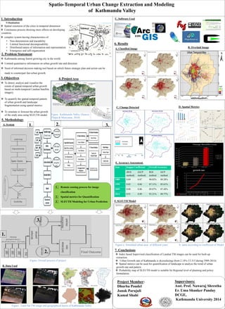
- 1. Spatio-Temporal Urban Change Extraction and Modeling of Kathmandu Valley 1. Introduction Spatial extension of the cities in temporal dimension Continuous process showing more effects on developing countries complex system having characteristics of: • Non-determinism and tractability • Limited functional decomposability • Distributed nature of information and representation • Emergence and self-organization Urbanization 2. Problem Statement Kathmandu among fastest growing city in the world. Limited quantitative information on urban growth rate and direction Need of informed decision making tool based on which future strategic plan and action can be made to counterpart fast urban growth. 3. Objectives To detect, analyze and visualize the extent of spatial-temporal urban growth based on multi-temporal Landsat Satellite imagery. To quantify the spatial-temporal pattern of urban growth and landscape fragmentation using spatial metrics. To simulate or forecast the urban growth of the study area using SLEUTH model. 4. Project Area 5. Methodology B. Data Used Figure : Land Sat TM image and geographical layers of Kathmandu Valley A. System 2. 2. Figure Overall process of project 6. Results A. Classified Image B. Overlaid Image C. Change Detected Final Outcome 1. Remote sensing process for image classification 2. Spatial metrics for Quantification 3. SLEUTH Modeling for Urban Prediction 1. 1. 2. 3. 3. C. Software Used D. Spatial Metrics 1989-1999 1999-2009 2009-2014 growth rate 2.14 5.58 13.33 0 2 4 6 8 10 12 14 Growth rate(%) growth rate E. Accuracy Assessment Year Kappa Coefficient Overall Accuracy (ROI method) (GCP method) ROI method GCP method 1989 0.89 0.87 90.02% 89.28% 1999 0.85 0.84 87.11% 85.61% 2009 0.88 0.86 89.87% 87.48% 2014 0.91 0.89 93.21% 89.77% F. SLEUTH Model Figure a. Simulated urban area of different years b. same according to coefficient of Model 7. Conclusions Index based Supervised classification of Landsat TM images can be used for built-up extraction Urban Growth rate of Kathmandu is skyrocketing (from 2.14%-13.315 during 1989-2014) Spatial metrics can be used for quantification of landscape to analyze the trend of urban growth rate and pattern Probability map of SLEUTH model is suitable for Regional level of planning and policy formulation. Supervisors: Asst. Prof. Nawaraj Shrestha Er. Uma Shanker Panday DCGE, Kathmandu University 2014 Figure Kathmandu Valley (Source: Thapa & Muriyama, 2010) Project Member: Dhurba Poudel Janak Parajuli Kamal Shahi