laninaA afreen
•Download as PPTX, PDF•
1 like•277 views

This document provides information about urbanization and its impacts. It defines urbanization as the shift from rural to urban living. The main causes of urbanization are natural population increase and migration to cities for jobs and amenities. As urbanization increases, it leads to several environmental issues like eutrophication from excess nutrients, arsenic poisoning from waste metals, and erosion from construction sites. The document also discusses solutions to mitigate the negative effects of urbanization like restoration of coastal habitats and erosion control methods.

Recommended
More Related Content
What's hot
What's hot (20)
Similar to laninaA afreen
Similar to laninaA afreen (20)
laninaA afreen
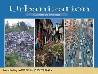
- 1. 1 Presented by:- AAFREEN AND CHITRAkALA
- 2. CONTENTS Defination Causes of urbanization Natural increase In-migration Requirement of urbanization Reason of urbanization Concentric zone model The concentration Urbanation increase Eutrofication Urbanization increase Arsenic poisoning Urbanization increase Erosion Implication Solution conclusion
- 3. DEFINATION Urbanization is a population shift from rural to urban areas, "the gradual increase in the proportion of people living in urban areas", and the ways in which each society adapts to the change. It predominantly results in the physical growth of urban areas, be it horizontal or vertical.
- 4. CAUSES OF URBANIZATION Natural Incéares- Townes like other areas of the country, grow in population as the people who live in them have Children. The Kingston- St. Andrew area in jamaica had 27.5% of Jamaica’s population and grew by 10.8% from 1991-2001. Im- Migration- Kingston Is also gaining population by people moving into the city from the rural areas. Between 1982 and 2001 It grew by 8.7% Port more which Is in close proximité to Kingston continues to grow rapidly due to the développement of commercial entities.
- 5. REQUIREMENT OF URBANIZATION • Reclassification- rural villages that have expanded rapidly to become towns are reclassified as urban areas. In such cases long-standing residents who were classed as rural dwellers become urban dwellers because their settlements have expanded in size. Social Amenities- Town provides chances of a better education ( since the best schools can be found there), improved healthcare facilities and recreation in the form of cinemas, race courses and playing fields. Towns offer a wider range of job opportunities.
- 6. Urban unemployment- Many persons who move into the city face unemployment due to lack of job opportunités. Over crowding -which leads to the development of slums and ghettoes. Crime and violence Spread of diseases due to unsanitary living conditions. Poor sewage disposal Systems. Urban Sprawl - As towns get bigger people move into agricultural lands. Traffic congestion Pollution.
- 7. URBANIZATION & THE POPULATION
- 8. URBANIZATION & THE POPULATION
- 9. CONCENTRIC ZONE MODEL He assumed that new migrants to a city move into inner city areas because they were the cheapest type of housing and were closest to the sources of employment. With time, residents move out of the inner city as they become wealthier. This was often the second generation migrants. In his model, housing quality and social class increased with distance from the city centre.
- 11. THE CONCENTRATION Every area has been affected by the rapid growth of people in some way. Trends show that continued urbanization will lead to a continued abundance of pollution in the world’s water.
- 12. URBANIZATION INCREASES EUTROPHICATION The process by which excessive amounts of nutrients cause an increase of algae growth These nutrients, like nitrogen and phosphorus, come from fertilizers and wash away with rainfall This increased growth upsets natural balance of the ecosystem and degrades the environment
- 13. NUTRIENT LOADING
- 14. URBANIZATION INCREASES ARSENIC POISONING Urban areas release large amounts of waste metals into local watersheds These metals compromise the safety of the area’s water supply
- 15. EFFECTS OF ARSENIC POISONING
- 16. URBANIZATION INCREASES EROSION Soil from construction sites washes away during rainfall and clogs natural water systems This leads to sewer overflows which release waste, oil, litter and other toxic materials into area’s coastal environment
- 17. IMPLICATIONS Urbanization continues to increase exponentially around the world. Understanding its effects on the environment is vital for safe and productive development in the future. Now that we know the negative effects of urbanization on coastal ecosystems, we can extend rescue and conservation techniques to the effected areas
- 18. SOLUTIONS •Restoration and Regulation of Tidal Hydrology •Shoreline Stabilization and Erosion Control •Stockpiling and Planting •Fertilization and Protection •Habitat Enhancement
- 19. CONCLUSIONS • Urbanization has negative affects on the coastal ecosystem and environment in general • Urbanization is highly concentrated along coastal regions which exacerbates the issue • There are effective ways to prevent these negative effects, also many innovative methods for restoration
- 20. INSULATION Input is received in the form of short-wave solar energy. This is called insulation. Insulation is solar radiation received in the Earth's atmosphere or at its surface. Only approximately 52 per cent of this insulation reaches the earth's surface. The rest is absorbed by water vapor, dust and clouds, or is reflected by the Earth's surface and scattered by particles in the air. This reflection is called the albedo. The albedo of an object is the extent to which it diffusely reflects light from the Sun. Reflected heat, in the form of long-wave radiation, is trapped in our atmosphere and keeps our planet warm. This is known as the “Natural greenhouse effect.” The diagram below shows this process - these figures are approximate.
- 22. BALANCE OF RADIATION AND HEAT Insulation is that amount of solar radiation that reaches the earth surface through shortwave The Earth also radiates heat energy like all other object. This is known as terrestrial radiation. The annual mean temperature on the surface of the earth is always constant. It has been possible because of the balance between insulation and terrestrial radiation This balance is termed as “HEAT BUDGET OF THE EARTH”
- 23. ALBEADO: A MEASURE OF HOW WELL A SURFACE REFLECTS INSULATION.
- 24. LATITUDE HEAT BALANCE The earth as whole, maintains balance between incoming solar radiation and outgoing radiation. but this is not so in relation to different latitude the amount of insulation received is directly to latitudes. In tropics where the insulation is high throughout the year. More solar energy is revised at the earth surface and in the atmosphere then is emitted back into space. In polar region, on the other hand there is more heat loss than received. This way the tropic should have been getting progressively hotter and pools progressively cooler but this is not so, because it energy transfer within the atmosphere prevents such a situation. The imbalance in the atmosphere and oceans created due to insulation produces winds and oceans current which transfer heat from surplus(tropical) region to deficit(polar) region and help in maintaining an over all balance on the surface of the earth. This is commonly know as latitudinal “HEAT BUDGET”
- 25. Let us suppose that the total received at the top of the atmosphere is 100 unit. Roughly 35 unit of it are reflected back into space even before reaching the surface of the earth. Top of the cloud, snow and ice covered region reflect 6 & 2 out of the 35 unit respectively. Out of the remaining 65 unit (100-35), only 51 unit reach the earth surface. 14 unit are absorbent by the various gases, dust particle and water vapor of the atmosphere.
- 26. WIND ROSE Contents introduction History Use Reference
- 27. INTRODUCTION A wind rose is a graphic tool used by meteorologists to give a succinct view of how wind speed and direction are typically distributed at a particular location. Historically, wind roses were predecessors of the compass rose (found on maps), as there was no differentiation between a cardinal direction and the wind which blew from such a direction. Using a polar coordinate system of gridding, the frequency of winds over a long time period is plotted by wind direction, with color bands showing wind ranges. The directions of the rose with the longest spoke show the wind direction with the greatest frequency.
- 28. HISTORY Before the development of the compass rose, a wind rose was included on maps in order to let the reader know which directions the 8 major winds (and sometimes 8 half winds and 16 quarter winds) blew within the plan view. No differentiation was made between cardinal directions and the winds which blew from said directions. North was depicted with a fleur de lis, while east was shown as a Christian cross to indicate the direction of Jerusalem from Europe.[1][2]
- 29. USE Presented in a circular format, the modern wind rose shows the frequency of winds blowing from particular directions over a specified period. The length of each "spoke" around the circle is related to the frequency that the wind blows from a particular direction per unit time. Each concentric circle represents a different frequency, emanating from zero at the center to increasing frequencies at the outer circles . A wind rose plot may contain additional information, in that each spoke is broken down into color-coded bands that show wind speed ranges. Wind roses typically use 16 cardinal directions, such as north (N), NNE, NE, etc., although they may be subdivided into as many as 32 directions.[3 ] In terms of angle measurement in degrees, North corresponds to 0°/360°, East to 90°, South to 180° and West to 270°. Compiling a wind rose is one of the preliminary steps taken in constructing airport runways, as aircraft typically perform their best take-
- 30. ANNUAL WIND ROSE WHEN CAMDEN NJ (340070003) PM 2.5 HOURLY DATA GREATER THAN 25 UG/M3 USING WIND SPEED AND DIRECTION DATA FROM THE CAMDEN SITE, PHILADELPHIA ARPORT, AND THE PADEQ CITY OF CHESTER STATION (420450002). Camden Vs Camden Camden Vs Philadelphia AP Camden Vs Chester PA DEQ Philadelphia All Hours WR
- 31. REFERENCES Dan Reboussin (2005)Wind Rose. University of Florida. Thoen, Bill. "Origins of the Compass Rose". Wind Rose Data.