Tanguar Haor

This research is the outcome of an academic report on “TANGUAR HAOR”. A semester paper under the course ‘Design Studio VIII’ was prepared by Group 01 of 4th year 2nd Semester summer 2018 of department of architecture, Leading University. We are acknowledging our contribution. The course is guided by AR. Shawkat Jahan Chowdhury and thanks to him for guided us sincerely. We are thankful to the villagers International Union for Conservation of Nature (IUCN), Mr. Kabir and Mr. Amin Ministry of Water Resources, Bangladesh Haor and Wetland Development Board and the people of those village we worked. We are also thankful to Bangladesh Polish and Border Grad Bangladesh (BGB) to ensure our safety from starting to the end. With out their help and participation the study and complete the report was not possible.

Recommended
Recommended
More Related Content
What's hot
What's hot (20)
Similar to Tanguar Haor
Similar to Tanguar Haor (20)
More from AHK Architets
Recently uploaded
Recently uploaded (20)
Tanguar Haor
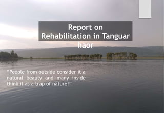
- 1. Report on Rehabilitation in Tanguar haor “People from outside consider it a natural beauty and many inside think it as a trap of nature!”
- 2. A REPORT ON TANGUAR HAOR Design Studio: VIII Course Code : ARCH- 404 Department Of Architecture Leading University. Submitted By, ID-1312010003 1512040011 1512040017 1512040020 1512040021 Submitted To AR. Shawkat Jahan Chowdhury The Head Department Of Architecture Leading University. Group: 01
- 3. Acknowledgements ---------------------------------------- Haor ---------------------------------------- Tangua haor ---------------------------------------- Location ---------------------------------------- Geogrphical features ---------------------------------------- Administrative jurisdiction ---------------------------------------- CONTENTS Climate ---------------------------------------- Topography ---------------------------------------- Sociological condition ---------------------------------------- DependentVillages ---------------------------------------- Resource status ofTanguar haor ---------------------------------------- Sociological condition ----------------------------------------
- 4. Causes of degradation ---------------------------------------- Flora ---------------------------------------- Fauna ---------------------------------------- Local Survey ---------------------------------------- Common characteristics ---------------------------------------- Occupation --------------------------------------- CONTENTS Circulation ---------------------------------------- Joypur ---------------------------------------- Alompur ---------------------------------------- Mujrai ---------------------------------------- Mundiata ---------------------------------------- Gonipara ----------------------------------------
- 5. Threats forTanguar Haor ---------------------------------------- Challenge ofTanguar Haor ---------------------------------------- InternationalCase Studies ---------------------------------------- Ko Panyi:Thailand’s Floating Village ---------------------------------------- TheWaterVillage of KampongAyer , Brunei ---------------------------------------- Ha Long Bay,Vietnam --------------------------------------- CONTENTS Chong Khneas,Combodia ---------------------------------------- Makoko Floating School II by Kunlé Adeyemi ---------------------------------------- References: ----------------------------------------
- 6. Acknowledgemen ts This research is the outcome of an academic report on “TANGUAR HAOR”. A semester paper under the course ‘Design Studio VIII’ was prepared by Group 01 of 4th year 2nd Semester summer 2018 of department of architecture, Leading University. We are acknowledging our contribution. The course is guided by AR. Shawkat Jahan Chowdhury and thanks to him for guided us sincerely. We are thankful to the villagers International Union for Conservation of Nature (IUCN), Mr. Kabir and Mr. Amin Ministry of Water Resources, Bangladesh Haor and Wetland Development Board and the people of those village we worked. We are also thankful to Bangladesh Polish and Border Grad Bangladesh (BGB) to ensure our safety from starting to the end. With out their help and participation the study and complete the report was not possible.
- 7. Haor A haor is a wetland ecosystem in the north eastern part of Bangladesh which physically is a bowl or saucer shaped shallow depression, also known as a back swamp. During monsoon haors receive surface runoff water from rivers and canals to become vast stretches of turbulent water. They turn into a vast inland seas within which the villages appear as islands. Occasional high winds during the rainy season (July to September) generate large waves in the haor, which may cause considerable damage to homesteads. However they all but dry up in the post-monsoon period. During winter, these haors are vast stretches of green land. Alir Haor Hakaluki Haor Sonir Haor
- 8. Tanguar haor located in the Dharmapasha and Tahirpur upazila of Sunamganj District in Bangladesh, is a unique wetland ecosystem of importance and has come into international focus. The area of Tanguar haor including 88 villages within the haor is about 100sq.km of which 2,802.36 sq.ha is wetland. It is the source of livelihood than 45,000 people. Tanguar haor Tanguar haor exhibits a unique wetland ecosystem. Considering its ecological importance it has been declared as the 2nd Ramsar site of Bangladesh in 2000. The swamp forest land of the haor is another unique ecological feature of the haor ecology. It plays an important role in fish production as it functions as a 'mother Characteristic
- 9. Location: Map Tanguar haor is one of the largest systems in the northeast region with relative natural state. It is located at 25° 05΄-25° 12΄ North/91° 01΄- 91° 07΄East. Approximately one-thirds lies in Tahirpur Upazila and two-thirds lies in
- 10. Location: Map Its total area is 9,727 hectares and there are at least 52 beels (Akonda, 1989; NERP, 1993) covering approximately 25-30 percent of the haor at the end of the dry season. The haor’s 13 northern boundary lies just 1-2 kilometers from the Indian border. The haor located at an altitude of only 2.5-5.5 meters above sea
- 11. Administrative jurisdiction: Tanguar Haor falls under the jurisdiction of Sunamganj District, two Upazillas (Tahirpur and Dharmapasha), and four Unions Sreepur Uttar, Sreepur Dakshin, Bongshikunda Uttar and Bongshikundo Dakshin.
- 12. Geographical feature: • Tanguar Haor is made up of 120 small, medium and large interconnecting beels some of which are perennial and others seasonal. • The area covered by these beels is approximately 10,000 hectares. • In the rainy season all the beels are united as one large lake, or haor, making Tanguar Haor the larger freshwater wetland in Bangladesh. Intermediate place between the Haor basin and homestead land are called “kanda”. • Usually reed swamp plants are found in these kanda. Kanda is fairly deeply flooded • during the rainy season and dry out during the dry season. • Tanguar haor becomes an important transport pathway particularly while it is flooded.
- 13. Climate: Yearly Total, Maximum and Average Rainfall at Tanguar Haor for 1980-2008: The monthly rainfall of Laurerghar near by Tanguar Haor is plotted in the following table. Analyzing the data it shows that the average maximum rainfall observed in August and the average minimum rainfall observed in
- 14. Climate: Yearly Maximum and Minimum Temperature (°c) at Tanguar Haor for 1981- 2010:
- 15. Topography: Tanguyar haor Located in Sunamganj District is a part of Meghna and Surma River Basin. Macro Scale:
- 16. Topography: Micro Scale: Tanguar haor has unflated lowland and it has an irregular surface on its top. In dry season the water bodes is locally called “bil” and the rest of area is called “kandi”. Total number of bil is 120 and totat number of Dry seasonRainy season Highland Lowland Fen
- 17. Sociological condition: About 45,000 peoples are living in 88 villages of the Tanguar Haor Ecomomic area. As the Haor floods annually, habitations are clustered along its slightly raised fringes. Fisheries and agriculture are the two main livelihoods for local people
- 18. Dependent villages:88 villages (Appendix-01) of Haor are within the landscape that are dependent upon haor for their livelihood and RRA/PRA conducted following 20 villages out of 88 villages:Table : Information collected from 20 Villages Of Tanguar Haor NAME OF VILLAGE House Number Community type Jaypur 65 Muslim Mujrai 40 Hindu Alampur 22 Muslim Gonipara 12 Muslim Chiriargaon 52 Muslim Cilani Tahirpur 100 Muslim Mundiata 198 Muslim Moyajuri 50 Muslim Rupnagar 500 Muslim Bakatala 400 Muslim, Hindu, Hojong
- 19. Dependent villages: NAME OF VILLAGE House Number Community type Bangalvita 300 Muslim, Hindu, Garo Kandapara 150 Muslim Goalgoan 200 Muslim, Hindu Rongchi 300 Muslim, Hindu Nichintopur 500 Muslim, Hindu Bongshikunda 100 Muslim Datiapara 300 Muslim Amanipur 50 Muslim, Hindu Dumal 150 Muslim Lamagoan 450 Muslim Patabuka 320 Muslim
- 20. Resource status of Tanguar Haor: • Fish and paddy are the two major resources of Tanguar Haor. People around TH depend also on it for fuel wood, fodder & thatching materials. • In the clump of Hijol, Barun, koroch, Nol khagra plant species fishes get their hiding place during monsoon; • people cut the branches of hizol, koroch for katha formation; collect nol for mat formation, fuel wood; People also collect Shotomul, Onontomul, Amrul for medicine etc. • According to local peoples no species yet been extinct but many plant and animal species become threatened due to the overextraction, sedimentation, hooves and grazing action of cattle etc. • Illegal fishing gear use, brood fish catching, hunting, dewatering of beels were extensively practiced before 5/10 years ago. • The illegal bird hunters kill the birds in the winter season and
- 22. Koroch tree Koroch tree Koroch tree Nol khagra Nol khagra
- 23. JarulTree JarulTree JarulTree Shotomul Shotomul Shotomul
- 24. Chitol Rani Bacha Rita Baush pabda
- 25. Crane Valture Storke Cormorant Dahuk Buzzard
- 26. Causes of degradation Day by the species and individual number of plant, fish and wild animals are decreasing. Both natural and manmade situations are the principal causes for the decreasing of biodiversity.
- 27. Flora is the plant life occurring in a particular region or time, generally the naturally occurring or indigenous—native plant life. Flor a
- 28. Flora Tanguar Haor supports a wide variety of floral species. Based on Karim (1993) and BNH (1997), it is estimated that a total of 200 wetland plant species occurred in Tanguar Haor. The most recent survey (2011) of IUCN has recorded 104 plant species under 88 genera and 51 families in this wetland (Sobhan et al., 2012). Principal wetland habitats of Tanguar Haor include open water (with submerged and floating aquatic vegetation), seasonally-inundated mixed herbaceous vegetation, reed beds and rice fields. Hijol (Barringtonia acutangula) and Koroch (Millettia pinnata) are dominant tree species in swamp forest, but these have now disappeared except for an occasional isolated tree and nearly a pure formation in the Rongchi ‘forest’, which is an 8-
- 29. Flora Different types of habitat and vegetation communities found inTanguar Haor are as follows: Submerged vegetation's: They are fully under water vegetations. Migratory dabbling ducks and some resident aquatic birds feed on parts of these vegetations. e.g: Hydrilla verticillata, Potamogeton crispus, Najas spp and Ottelia alismoides Free floating vegetation's: Free floating vegetations found in Tanguar Haor are used as nesting sites by some aquatic birds such as Pheasant- tailed Jacana, Bronze-winged Jacana, Purple Swamphen, Whiskered Tern, etc. Rodents found in haor also live in and build nests inside such floating vegetation. (e.g., Eichhornia crassipes, Utricularia aurea and Sylvania
- 30. Flora Rooted floating vegetation's: Fish fingerlings often take refuge in such plants while others feed on algae growing on these plants.Aquatic insects and snails also feed on these plants. (e.g.,Trapa maximowiczii, Echinochloa colona, Hygrorhyza aristata and Limnophila indica). Sedges and meadows vegetation's: These types of vegetation provide shelter and food source of some aquatic animals. Local people also take some vegetation as food and some are used for making mats of various types. e.g.,Alternanthera philoxeroides, Schumannianthus dichotomus, Eclipta alba, Enhydra fluctuans and Scirpus juncoides.
- 31. Flora Reed vegetation's They are the main nesting ground of some resident ducks viz., Spot-billed Duck, Cotton Pygmy Goose and some other aquatic resident birds. e.g.Asclepias vcurassavica,Asparagus racemosus, Ficus heterophylla, Lippia alba and Phragmatis karka) Freshwater swamp forest vegetation's They are natural and locally introduced species consist of evergreen trees forming dense canopy. Some birds and mammals use this type of forest as roosting and nesting places. e.g., Barringtonia acutangula, Millettia pinnata,Crataeva magna, Phyllanthus distichus andTrewia nudiflora
- 32. Flora Crop field vegetations Crop field vegetations have been found around the Tanguar Haor which are important source of food for migratory ducks and fodder for cattle. e.g.,Alternanthera sessilis,Cotula hemisphaerica, Cynodon dactylon and Cyperus cephalotes Homestead vegetations Homestead vegetations have been found inTanguar Haor with rich species diversity. Many species of terrestrial birds take shelter in such vegetation and build nest or roost on the trees and bamboos. (e.g., Barringtonia acutangula, Bambusa arundinacea, Dendrocalamus strictus, Musa paradisiaca,Areca catechu, Calamus tenuis, Caryota urens, Cocos nucifera
- 33. Fauna Fauna is all of the animal life of any particular region or time. The corresponding term for plants is flora. Flora, fauna and other forms of life such as fungi are collectively referred to as biota.
- 34. Fauna Every winter the haor is home to about 200 types of migratory birds. The haor is an important source of fish. There are more than 140 species of fresh water fish in the haor. The more predominant among them are: ayir, gang magur, baim, tara, gutum, gulsha, tengra, titna, garia, beti, kakia etc.
- 35. Fauna
- 36. Fauna Migratory water Birds Bangladesh becomes the destination for hundreds of bird species every winter. Birds from the remotest corners of the world such as Siberia, Mongolia, and the Tibetan plateau come to Bangladesh to enjoy the country's temperate winter and to feed from the bounty of fish in the shallow rivers and canals. Resident water Birds This types of birds lived in this area or domestic.
- 37. Fauna Common Fish Bangladesh is a country with thousands of rivers and ponds and is notable for being a fish-loving nation. Some types of fishes are available in hole country including Tanguar Haor. Catfish Catfishes are a diverse group of ray-finned fish. A few number of catfish species live in this Haor.
- 38. Fauna Reptile 39 reptile species lives in tanguar Haor. Amphibians 15 amphibian species lives in tanguar Haor. Mammals 30 mammal species lives in tanguar Haor.
- 39. Local Survey: To know their settlement and life style we’ve survey 5 of their villages, name as- Joypur Alompur Gonipara Mondiata Mujrai
- 40. Common characteristics:Barrier: Every village has a barrier around it for protection from water wave and erosion. In survey we’ve found four types of barriers. Such as- Bamboo fence Sand sack Stone Concrete block Bamboo fence: Advantage: o Easily available o Cheap rate Disadvantages o Poor Stability o Not sustainable o Tough maintenance
- 41. Sand sacks: Advantage: o Easily available o Cheap rate Disadvantages o Poor durability o Poor sustainable Stone: Advantage: o Available o High durability o Sustainable Disadvantages o Costly o Tough Maintenance Concrete Blocks Advantage: o Available o High durability Disadvantages o Costly o Tough Maintenance
- 42. Shops Total 16 shop for 3500-4000 people of 5 survey area. Limited goods Not Sufficient Comparatively costly. The shop is use as a gathering space between themselves. The villagers do chatting in their leisure time.
- 43. Circulations Narrow circulation No direction Undefined pathway Full of clay
- 44. Occupation Wetland resources play a critical role in the lives of those residing in and around Tanguar Haor. Most economic activity carried out in the area, including commercial fishing, trade in fuel wood, hunting and trapping waterfowl. Dried-Fish Fishing Agriculture
- 45. Occupation
- 46. Occupation
- 47. Settlements Pattern Most of the villages are linear pattern.
- 48. Joypur: Village/Area Name: Joypur Location: Uttar Shreepur, Tahirpur, Sunamgonj. Community: One Village Council Number of Houses: 65 Population: 450 Electricity: No electricity, a few number of houses use solar panel system. Sanitary: Poor Occupation: Agriculture, Fishing, farming, labor Vegetation period: Falgun to Water source: Tube well Number of tube well: 4 Health facilities: No Minimum distance to Hospital: 5km (Srepur Hospital), 9 km (Taahirpur) Education facilities: No Minimum distance to Primary School: 1km Minimum distance to Secondary School: 5km Number of shops: 3 nos The reasons of their living: They are not able to survive
- 49. Plan:
- 50. Plan:
- 51. Pathway YardCattle house Findings: Tight space No play ground No deviation between human living area and domestic animals. Every family has minimum a boat or more. They use the front side of house as Ghat to keep their boats. Concrete dam wall for protection from Boat
- 52. Village/Area Name: Alompur Location: Uttar Shreepur,Tahirpur, Sunamgonj. Community:VillageCouncil Number of Houses: 22 Population: 180 Electricity: No electricity, a few number of houses use solar panel system. Sanitary: poor Occupation:Agriculture, Fishing, farming, labor Vegetation period: Falgun to Alompur Water source:Tube well Number of tube well: 1 Health facilities: No Minimum distance to Hospital: 2km (Srepur Hospital) Education facilities: Primary Minimum distance to Primary School: 1km Minimum distance to Secondary School: 3km Number of shops: 1 nos The reasons of their living: They are not able to survive anywhere else due to financial
- 53. Plan
- 54. Findings: Tight housing space They make home craft like fishing materials, Net and pottery. No deviation between human living area and domestic animals. Every family has minimum a boat or more. They use the front side of house as Ghat to keep their boats. Pottery Bamboo dam Interior space
- 55. Village/Area Name: Mujrai Location:Uttar Shreepur,Tahirpur, Sunamgonj. Community: OneVillageCouncil, Kalibari Mondir Number of Houses: 40 Population: 220 Electricity: No electricity, a few number of houses use solar panel system. Sanitary: poor Occupation:Agriculture, Fishing, farming, labor Vegetation period: Falgun to Agrahayan Mujrai Water source:Tube well Number of tube well: 1 Health facilities: No Minimum distance to Hospital: 6km (Srepur Hospital) Education facilities: No Minimum distance to Primary School: 1.5km Minimum distance to Secondary School: 6km Number of shops: 3 nos
- 56. Plan
- 57. Findings: Because of religious cultural facts, orientation of their houses length direction in north-south. The prayer space is in the right side of the house. They make home craft like fishing materials, Net and pottery. Comparatively clean. They use the front side of house as Stone block CleanYard Prayer Space Net Preparing
- 58. Village/Area Name: Mundiata Location: Uttar Shreepur,Tahirpur, Sunamgonj. Community:ThreeVillage Council 2 mosque Number of Houses: 350 Population: 2500-3000 Electricity: No electricity, a few number of houses use solar panel system. Sanitary: poor Occupation:Agriculture, Fishing, farming, labor Vegetation period: Falgun to Agrahayan Mundiata Transportation: Local boat system Water source:Tube well Number of tube well: 10 Health facilities: No Minimum distance to Hospital: 2km (Srepur Hospital) Education facilities: Primary Minimum distance to Primary School: -- Minimum distance to Secondary School: 3km Number of shops: 10 nos
- 59. Findings: The village is madden with three different land and three land are connected by two traditional bamboo bridge. The only village have a primary school that we’ve surveyed. Good incompletion about vegetation and tree plantations The villagers use a common transportation system to connected themselves with Vegetation On the way to School Primary School Local
- 60. Village/Area Name: Gonipara Location: Uttar Shreepur,Tahirpur, Sunamgonj. Community: OneVillageCouncil no mosque Number of Houses: 12 Population: 70 Electricity: No electricity, a few number of houses use solar panel system. Sanitary: poor Occupation:Agriculture, Fishing, farming, labor Vegetation period: Falgun to Agrahayan Gonipar a Water source:Tube well Number of tube well: 1 Health facilities: No Minimum distance to Hospital: 3.5km (Srepur Hospital) Education facilities: Primary Minimum distance to Primary School: 1.5km Minimum distance to Secondary School: 3km Number of shops: no
- 62. Findings: They depend on indoor game to pass their time. They make home craft like fishing materials, Net and pottery. No deviation between human living area and domestic animals. They use the front side of house as Ghat to keep their boats. Bamboo fence dam for protection from Cattle Carom Bamboo fence dam Green Vegetation
- 63. Threats for Tanguar Haor and its resources: 1. Over extraction of fisheries resources 2. Over extraction of fuel wood 3. Land encroachment 4. Unplanned irrigation system 5. Loss of bird population through hunting 6. Loss of other wild animal through over harvesting 7. Conversion of agricultural land 8. Poor enforcement of fisheries and wildlife protection act 9. Use of insecticide in the crop field 10. Lack of awareness 11. Loss of fish fertility due to use of pesticide and herbicide 12. Lack of alternative income for dependent people
- 64. Challenges for Haor and its resource conservation: 1. Illegal fishing 2. Control over extraction of resources 3. Reduce local poverty and unemployment 4. Active participation of GoB concerned department 5. Recovery of encroached land 6. Reduce insecticide, herbicide and pesticide use 7. Stop bird and other wildlife killing through hunting 8. Control cattle grazing 9. Ensure natural water flow 10. Control the use of harmful fishing gear 11. Interfere of influential people 12. Protection of natural hizol, koroch seedlings 13. Lack of proper transport for field work 14. Support from Government Officers
- 66. Ko Panyi:Thailand’s Floating Village • Ko Panyi is a fishing village in Phang Nga. • There is a school, a mosque, a health center, lots of small shops, a large restaurants and even a floating football pitch • The village is famous for a floating football pitch. Ko Panyi
- 67. People • There are 1,485 people from 315 families who live permanently on Koh Panyee. • All of them are the descendants, directly or indirectly ofToh Baboo and his family and friends, who were the first people to settle on Koh Panyee some 200 years ago. • The hundreds of huts, shacks, restaurants and houses where the villagers live are built on stilts over the surrounding shallow sea . • The village has its own school, a mosque, a health center, lots of small souvenir shops and a handful of large restaurants, all facing the sea, where tourists can enjoy a fresh seafood lunch. • The latest development on Koh Panyee is the construction of bungalows that offer overnight accommodation for as little as 300 baht. Functions
- 68. Aerial view of Ko Panyi, fishing village in Phang Nga Province, Thailand Ko Panyi, fishing village in Phang
- 69. Football field floating on the sea of village
- 70. The Water Village of Kampong Ayer , Brunei Kampong Ayer is the world’s biggest settlement on stilts. • Brunei's capital city Bandar Seri Begawan, is a settlement consisting of 42 contiguous stilt villages called Kampong Ayer, or the Water Village, which has been inhabited for over 1,300 years. • Half of the city’s population live here — about 30,000 people, which is nearly 10% of the entire population of the country • . Kampong Ayer is the world’s biggest settlement on stilts. Peopl e
- 71. Different view ofThe WaterVillage
- 72. Functions • There are schools, police stations, fire stations, clinics, markets and mosques, all constructed on stilts and linked together by 36 kilometers of walkways and footbridges. • Houses are simple but modern and built with concrete and wood. • Each house is supplied with electricity and clean water.Transport lines, sanitation, garbage disposal system, internet access and postal service are some of the amenities available.• The houses, thus villages, of KampongAyer are interconnected with bridges and walkways,[ wooden and concrete, creating contiguous areas. • Accessibility among many villages are possible by foot. • Among non-contiguous areas and where the villages are not located along the riverbanks, these areas are accessible by water transport, whereby the most common transport mode is the 'water taxis' .
- 73. • All houses have air conditioning, electricity, internet access and satelliteTV. • Almost all the villagers have bikes, some have motorcycles and even cars, which they keep in the parking lot at the entrance to KampongAyer. • Inside the village have water taxi – the fastest and most reliable transportation in the area. • Water taxis are different in size, and some resemble regatta boats. • There are school boats to take kids to school, and, of course, tourist boats. Extra Facilities
- 74. • Ha Long Bay is in northernVietnam, 170 km east of HanoiThe bay is famous for its scenic ocean karst topography and is often included in lists of natural wonders of the world. • Ha long Bay is a bay located in the area of the Gulf ofTangkia, north of the Socialist Republic ofVietnam. • It has an area of 1,500 square kilometers and has a coastline about 120 kilometers away from Hanoi.The name was based on the pronunciation in theVietnam language "Viet Nam Ha Long". Ha Long Bay, Vietnam Dinnertime in a
- 75. The people here are fishermen, and their lives are intrinsically tied to the ocean. They have built boats and floating homes that provide their shelter, their transportation, and their culture.They can tie their homes to their neighbors, or they can drift off while they hunt for fish, lobsters, shellfish, and squid.They own no land, only the boats that provide their way of life. The simple life in Halong Bay floating People
- 76. Communi ty • Modern times still very reminiscent of the old days of trading in Vung Vieng • The 50 or so homes, there was one ‘community center’ which was constructed as a location for meetings. • The most affluent families had tiled rooves, radio sets, televisions, and furniture- although now almost the entirety of the village is a museum of sorts, for the homes that once were.
- 77. Chong Khneas, Combodia • The best handyman living among the boat people in Chong Koh was named Taing Hoarith. • Chong Koh is one of hundreds of floating villages . • comprising tens of thousands of families, on the Tonle Sap River and the lake of the same name in Cambodia. • Dangers on a floating village multiply in the rainy season. • Floating temples, churches, schoolrooms and oil-black ice factories. the large provincial capital.
- 78. A child plays with a kite on the roof in Chong Koh. Playing xiangqi on the porch of a floating house
- 79. Makoko Floating School II by Kunlé Adeyemi Makoko Floating School is a prototype floating structure, built for the historic water community of Makoko, located on the lagoon heart of Nigeria’s largest city, Lagos. As a pilot project, it has taken an innovative approach to address the community’s social and physical needs in view of the impact of climate change and a rapidly urbanizing African context. Its main aim is to generate sustainable, ecological, alternative
- 80. The structure is a replica of the MacBook Floating School designed in Lagos by the Nigerian architect KunléAdeyemi (b. 1976), founder and principal of the practice NLÉ and winner of the Silver Lion award for this year’s edition of the Biennale. MacBook Floating School Structure
- 81. Difference view of Makoko Floating School
- 82. • In Makoko, a sprawling slum on the waterfront of Lagos, Nigeria • tens of thousands of people live in rickety wood houses teetering above the fetid lagoon. • It’s an old fishing village on stilts, increasingly battered by floods from heavy rains and rising seas. • Because the settlement was becoming dangerous, the government forcibly cleared part of it last year. Kunle Adeyemi, a Nigerian architect, had a better idea. He and his team asked what the community wanted, and with its help and money from the Heinrich Böll Foundation and the United Nations, he devised a floating school: a low-cost three-story A-frame, buoyed by about 250 plastic barrels, with a 1,000-square-foot play area, classrooms, rainwater collection and composting toilets. Made to serve 100 elementary-school children, the building provides a flexible and robust prototype for housing and Why this school?
- 83. Interior of MacBook Floating School The floating school, which can accommodate up to 100 pupils, encompasses a play area, a workshop and classrooms, arranged on three levels.
- 84. The 220 square-meter floating school is made of roughly 13 tons of timber and one of metal, supported by a pontoon composed of 256 plastic barrels. The structure was conceived to be easily assembled also by non- specialized workers, to be cheap, functionally flexible, and capable to adapt to the changing level of waters of lagoons or of flood-prone areas. Plan Elevati on
- 85. • NLÉ's Makoko Floating School Reportedly Collapses Due to Heavy Rain • Makoko Floating School, designed by Nigerian architect Kunlé Adeyemi NLÉ, has collapsed after heavy rain battered the city of Lagos. • Photographs show the roof of the school still largely in tact, but sitting on top of the building's floating base of 256 plastic drums, as the lower and supporting structure appear to have failed completely. Collapsing:
- 86. References: IUCN, International Union for Conservation of Nature Global Environment Fund Ministry of Environment and Forests Bangladesh Forest Department Climate Change Resilient Fund Climate Change Trust Fund The Ramsar convention on werlands. (2011) Wikipedia The Ramsar convention on werlands. www.ramsar.org
- 87. Than k You