
Recommended
Recommended
More Related Content
Similar to field methods.ppt
Similar to field methods.ppt (20)
More from SaadTaman
More from SaadTaman (20)
Recently uploaded
Recently uploaded (20)
field methods.ppt
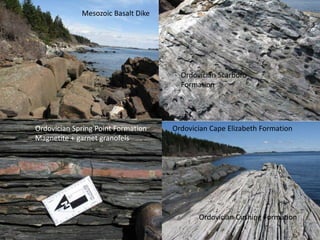
- 1. Mesozoic Basalt Dike Ordovician Scarboro Formation Ordovician Spring Point Formation Magnetite + garnet granofels Ordovician Cushing Formation Ordovician Cape Elizabeth Formation
- 2. Finished geologic map of Cliff Island made in ArcMAP and Adobe InDesign
- 3. Commingling of two magmatic fluids; one granitic the other gabbroic
- 4. S39: Geology of the Maine Coast by Sea Kayak 2009 Dyk Eusden, Department of Geology 786 6152, deusden@bates.edu, 212 Carnegie Important things and dates: This is an extra cost short term, approx $ 1,500 per student. Submit the application form to me before the end of the first week of winter semester if you want to enroll in this short term. Deadline for financial aid application is January 19, 2009. Financial aid award decisions are made on February 2, 2009. Registration for extra cost short terms, February 7-13, 2009.
- 6. Cliff Island – Metasedimentary rocks, tilted, good starting project Isle Au Haut – Commingled intrusive igneous rocks, “think like a fluid” Roque Islands – Volcanic lava flows, sills, and fossiliferous sedimentary rocks, more difficult, much of it previously unmapped Cliff Isle Au Haut Roque Islands
- 7. Geology of the Roque Island Archipelago Hickey Island Halifax Island Little Spruce Island Marsh Island
- 8. Roque Islands Geology Overview • Late Silurian, Early Devonian • Double subduction zone • Basalt lava flows • Pyroclastic flows, ash tuffs • Sedimentary shales and slitstones with fossils • Faults Where we’ll be… From the student’s PPT
- 9. Hand drawn map of Hickey Island – last project
- 10. So, why teach field methods this way? Hands-on, experiential, outdoor education to complement the normal indoor setting. Complete experience: diverse geologic environments, low impact-leave no trace, kayaking– navigation skills, weather, group dynamics. An introduction to Maine bedrock geology and field methods through its natural settings. Gives students a sense of place. It is rewarding, adventurous, and fun. Students love it.
- 27. Conclusions After impoundment, numerous landslides have been found continually along the banks of the Dagangshan reservoir, which mainly include shallow slides in Quaternary accumulative layers or fracture rock masses with severe unloading and weathering. These also include seven unstable deformation slopes that can be classified into accumulative landslides and softened rock landslides that present failure phenomena for local collapses near the water surface and tensile cracks in the trailing edges of the slopes, which are induced by large deformation, as well as the characteristics of evolutionary failure tendencies from shallow slides to deep-seated slides resulting from long creep histories. As a whole, the landslides that have occurred in the Dagangshan reservoir are associated with reservoir water levels and precipitation directly or indirectly from the perspective of their temporal distribution. Meanwhile, man made disturbances also play a crucial role in the development of landslides. Spatially, these landslides are mainly distributed in the reservoir tail and middle, are presented within a linear distribution along the Dadu River fault and the Moxi fault. with large seismic belts and are mainly developed within deposits and softened rocks, which are sensitive to water. Three typical slopes with deformation patterns are selected to exhibit the deformation and failure processes of the reservoir bank slopes in the Dagangshan reservoir, which indicate that the initial water storage and subsequent fluctuations of the water level (including precipitation) made small contributions to the Mogangling slope due to better rock lithologies and drainage capacity within the sliding zone. However, the Xinhua slope and the Zhengjiaping slope present large deformation, local collapses and tension cracks under the direct effects of rainfall infiltration on the basis of thelong- term influences of reservoir water levels (manmade disturbances are alsoincluded). Moreover, based on the recognition of the deformational and failure processes of the typical slopes, two types of failure models are proposed to interpret the failure mechanisms of the deformation slopes in the Dagangshan reservoir, including a creep–shear–tension failure model and a toppling–tensile–shear failure model. The extent of the development and distribution of reservoir landslides in the Dagangshan reservoir is not prominent relative to the Maoergai or Jinping-I reservoirs of south-west China. A comparative analysis of reservoir operations is presented, which preliminarily infers that in addition to the effects of geological conditions, smaller-scale fluctuating water levels are important external factors influencing the non-significant development of landslides in the Dagangshan reservoir