LOGO
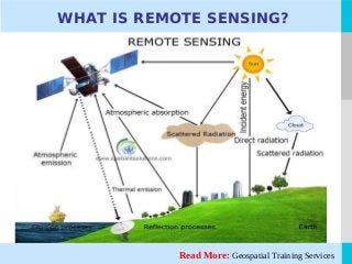
Remote Sensing isthe technique that is used for obtaining information about objects by analyzing the
data that is collected by special instruments that do not have any physical contact with the object/s
under investigation.
Alternatively, it can be termed as acquiring the salient information of an object or aspect without the
need to physically touch it. The technique generally makes use of aerial sensor technologies that
detect or classify the objects on earth by means of electromagnetic radiations that are emitted by
aircraft or satellites. The two main components of remote Sensing are “Data Capture” and “Data
Analysis”.
The technique is used in Geospatial Consulting Services. Remote Sensing differs from In-situ
sensing, where in the instruments that are used for detection are immersed in, or are physically
brought into contact with the objects of measurement. One common example of an In-situ instrument
is the soil thermometer.
Remote Sensing is broadly categorized into two main types:
1. Active Remote Sensing
2. Passive Remote Sensing
Read More: GIS Mapping Training Online
REMOTE SENSING
4.
LOGORead More: SpatialData Analysis
REMOTE SENSING
In Passive Remote Sensing passive sensors are able to detect the natural radiations that are emitted by
objects and their surrounding areas. They respond to external stimuli. Reflected sunlight is the most
common source of radiation that is measured by passive sensors. Charge-coupled devices, infrared
and radiometers are some examples of passive sensors.
As the name also suggests in Active Remote Sensing Active sensors are used to measure the
radiations that are reflected back from the target bodies. They respond to internal stimuli. RADAR is
a common example of active remote sensing technique. A RADAR measures the time delay between
the emission and return of a radiation, based on which it calculates the location, speed and the
direction of an object.
Following are the application areas for Remote Sensing technology:
Ocean Applications: The technique of remote Sensing can also be used to monitor ocean circulation
and current system. It is also used to measure ocean temperature and the wave heights. Remote
sensing can also be used to track sea ice or in cases where you want to get a better understanding of
the oceans and manage ocean resources.
5.
LOGO
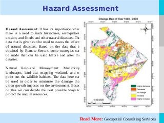
Hazard Assessment
Hazard Assessment:It has its importance when
there is a need to track hurricanes, earthquakes,
erosion, and floods and other natural disasters. The
data that is given can be used to assess the effects
of natural disasters. Based on the data that is
obtained by Remote Sensors some strategies can
be made that can be used before and after the
disaster.
Natural Resource Management: Monitoring
landscapes, land use, mapping wetlands and to
point out the wildlife habitats. The data here can
be used in order to minimize the damage that
urban growth imposes on the environment. Based
on this we can decide the best possible ways to
protect the natural resources.
Read More: Geospatial Consulting Services
6.
LOGORead More: GISJobs Training
REMOTE SENSING
Coastal Applications: Remote Sensing is used to monitor the changes that occur on the shoreline or
even in the case of tracking sediment transport etc. The data that is obtained by Remote Sensing can
also be used for coastal mapping and for preventing erosion.
The complete remote sensing process can be summarized as follows:
The data is captured by the Remote Sensors, such information is recorded and then analyzed by some
interpretive and measurement techniques. This is done in order to provide useful information about
the objects that are under investigation. The techniques are diverse and vary from the traditional
methods of visual interpretation to the methods using computer processing.
7.
LOGO
Thanks For Reading
Ayoung company led by professionals who bring on board comprehensive work and
research experience having previously served as specialists in leading organizations.
Management of SISPL has a strong commitment towards research and enhancement of
the outreach of the benefits of the powerful GIS technology at grassroots level especially
in the developing countries like India.
Website: http://spatialitsolutions.com/
Blog: http://geospatialconsultingservices.blogspot.in/
Google Plus: http://goo.gl/40o1E6
Facebook: http://www.facebook.com/spatialitsolutions
https://www.facebook.com/gistraininginjaipur
Pinterest: http://www.pinterest.com/SISPL
Twitter: https://twitter.com/SpatialITSoluti
E-Mail: Patronage@spatialitsolutions.com
Mobile: +91 097722-33443


![Vibe Coding vs. Spec-Driven Development [Free Meetup]](https://cdn.slidesharecdn.com/ss_thumbnails/vibecodingvsspecdrivendevelopment-251209105622-43f455e7-thumbnail.jpg?width=640&height=640&fit=bounds)


