OGC query 2014
•
1 like•178 views

This query relates to the origin (part) of OGC and the difficulty in transforming into a geospatial information infrastructure. This query has been asked over a number of years and remains relevant in 2018.
![APPRECIATING that the use of computers for mapping has been in existence for four decades. And in that time there have been many
innovative proposals, as for Craig FIELDS, US Defense Advanced Research Projects Agency, presenting a paper titled Beyond
Electronic Paper at the First International Advanced Study Symposium on Topological Data Structures for Geographic
Information Systems at Harvard University, October 1977;
REMEMBERING that standards and interoperability were recognized in 1983 by various bodies, including the Moellering Committee
[National Committee for Digital Cartographic Data Standards] in the US [1], and with the formation of DGIWG (Digital Geographic
Information working Group) – a military body made up of [then] NATO representatives;
ACHNOWLEDGING that the US Defense Mapping Agency (DMA) recommended R&D cooperation with Australia (being a Non-NATO
Ally) to develop a World Data Base noting that “R&D activity is appropriate because of their experience in digital cartography”.
Funding was approximately US$10 million.
[1] Working Group II on Data Set Quality proposed a "truth in labeling" approach to data set quality and the categories of quality information
that should be made available to a prospective user of a data set.
[2] Cliff Kottman was an early participant in OGC.
ORIGINS
R&D OPPORTUNITIES
o PROTOTYPE & TEST PROTOCOL LEVELS FOR “WORLD DATA BASE” PROJECT
o PROVIDING USER-FRIENDLY INTERFACES TO DATA, E.G. INDEX SCHEMES, GAZETTEERS, OVERVIEWS
o EXTRACTING DERIVATIVE DATA SETS
o CREATING ANALYSIS ROUTINES TO MEASURE LENGTH, AREA & OTHER STATISTICS
o ADDING INFORMATION IN SPECIFIC OVERLAYS (SOILS, GEOLOGY, WEATHER, CLIMATE, CADASTRAL DATA, VEGETATION, ETC)
BENEFITS TO Department of Defense
o ESTABLISHMENT OF STANDARDS & INTEROPERABILITY IN EXCHANGE OF DIGITAL SPATIAL INFORMATION, ESPECIALLY DIGITAL
MAPS & CHARTS
o PROVIDES INCENTIVES TO WORLDWIDE ADP MANUFACTURERS TO CONFORM TO THE STANDARDS
o DEVELOPMENT OF A RICH SUITE OF SOFTWARE UTILITIES FOR THE EXPLOITATION OF DIGITAL MAPS USED FOR MODERN
INTELLIGENCE, MISSION PLANNING, COMMAND & CONTROL, LOGISTICS, TRAINING AND WEAPON SYSTEMS
The proposal was prepared by M. Lohr, Jr and Dr C. KOTTMAN [2], DMASC on 24 August 1987.
2](data:image/gif;base64,R0lGODlhAQABAIAAAAAAAP///yH5BAEAAAAALAAAAAABAAEAAAIBRAA7)
Recommended
Recommended
More Related Content
Similar to OGC query 2014
Similar to OGC query 2014 (20)
More from Robert (Bob) Williams
More from Robert (Bob) Williams (20)
Recently uploaded
Recently uploaded (20)
OGC query 2014
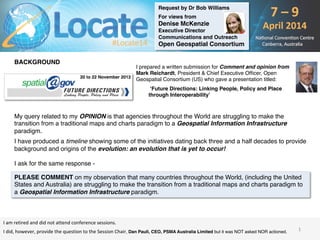
- 1. Request by Dr Bob Williams For views from Denise McKenzie Executive Director Communications and Outreach Open Geospatial Consortium BACKGROUND I prepared a written submission for Comment and opinion from Mark Reichardt, President & Chief Executive Officer, Open Geospatial Consortium (US) who gave a presentation titled: ‘Future Directions: Linking People, Policy and Place through Interoperability’ My query related to my OPINION is that agencies throughout the World are struggling to make the transition from a traditional maps and charts paradigm to a Geospatial Information Infrastructure paradigm. I have produced a timeline showing some of the initiatives dating back three and a half decades to provide background and origins of the evolution: an evolution that is yet to occur! I ask for the same response - 20 to 22 November 2012 I am retired and did not attend conference sessions. I did, however, provide the question to the Session Chair, Dan Paull, CEO, PSMA Australia Limited but it was NOT asked NOR actioned. PLEASE COMMENT on my observation that many countries throughout the World, (including the United States and Australia) are struggling to make the transition from a traditional maps and charts paradigm to a Geospatial Information Infrastructure paradigm. 1
- 2. APPRECIATING that the use of computers for mapping has been in existence for four decades. And in that time there have been many innovative proposals, as for Craig FIELDS, US Defense Advanced Research Projects Agency, presenting a paper titled Beyond Electronic Paper at the First International Advanced Study Symposium on Topological Data Structures for Geographic Information Systems at Harvard University, October 1977; REMEMBERING that standards and interoperability were recognized in 1983 by various bodies, including the Moellering Committee [National Committee for Digital Cartographic Data Standards] in the US [1], and with the formation of DGIWG (Digital Geographic Information working Group) – a military body made up of [then] NATO representatives; ACHNOWLEDGING that the US Defense Mapping Agency (DMA) recommended R&D cooperation with Australia (being a Non-NATO Ally) to develop a World Data Base noting that “R&D activity is appropriate because of their experience in digital cartography”. Funding was approximately US$10 million. [1] Working Group II on Data Set Quality proposed a "truth in labeling" approach to data set quality and the categories of quality information that should be made available to a prospective user of a data set. [2] Cliff Kottman was an early participant in OGC. ORIGINS R&D OPPORTUNITIES o PROTOTYPE & TEST PROTOCOL LEVELS FOR “WORLD DATA BASE” PROJECT o PROVIDING USER-FRIENDLY INTERFACES TO DATA, E.G. INDEX SCHEMES, GAZETTEERS, OVERVIEWS o EXTRACTING DERIVATIVE DATA SETS o CREATING ANALYSIS ROUTINES TO MEASURE LENGTH, AREA & OTHER STATISTICS o ADDING INFORMATION IN SPECIFIC OVERLAYS (SOILS, GEOLOGY, WEATHER, CLIMATE, CADASTRAL DATA, VEGETATION, ETC) BENEFITS TO Department of Defense o ESTABLISHMENT OF STANDARDS & INTEROPERABILITY IN EXCHANGE OF DIGITAL SPATIAL INFORMATION, ESPECIALLY DIGITAL MAPS & CHARTS o PROVIDES INCENTIVES TO WORLDWIDE ADP MANUFACTURERS TO CONFORM TO THE STANDARDS o DEVELOPMENT OF A RICH SUITE OF SOFTWARE UTILITIES FOR THE EXPLOITATION OF DIGITAL MAPS USED FOR MODERN INTELLIGENCE, MISSION PLANNING, COMMAND & CONTROL, LOGISTICS, TRAINING AND WEAPON SYSTEMS The proposal was prepared by M. Lohr, Jr and Dr C. KOTTMAN [2], DMASC on 24 August 1987. 2
- 3. NOTING that the World Data Base morphs to International Map and Chart Database and then Digital Chart of the World (DCW). Australia’s involvement in the R&D project was through a formal Memorandum of Understanding with the US government. Australia’s role on the Project was as agreed in Australian Treaty Series 1990 No.23 “Agreement between the Government of Australia and the Government of the United States of America Concerning Cooperative Development of the Digital Chart of the World” [3]. The DCW Project was successful in that it: o Created a global database of topologically structured data in a relational form (suitable for use in GIS) o Made a positive contribution to exchange standards and, thereby, interoperability o Was the catalyst for the development of viewing software through VPFVIEW (ESRI developed a commercial product called ARCVIEW) o Was the catalyst for the establishment of cooperative programs such as VaCWG (Vector ‘smart’ map Working Group) o Was the forerunner of technical developments embraced by DGIWG (Digital Geographic Working Group) Roberta E. (Bobbi) LENCZOWSKI (DMASC) was a lead US participant [4] [3] Under authority of the Governor-General In Council. [4] Then Major Dr Bob Williams was an Australian participant NOTING that Bobbi LENCZOWSKI published a landmark paper titled The Global Geospatial Information and Services Initiative in 1994. RECOGNISING that the United States Defense Science Board presented a report titled Report of the Defense Science Board on Defense Mapping for Future Operations in September 1995. The Task Force concluded that the US Department of Defense (DoD) should transition from emphasis on standard scale map and chart production to providing a readily accessible source of digital information which will satisfy military geospatial, mapping, charting and weapon systems requirements. OBSERVING that the Chairman of the US DSB was Craig FIELDS. NOTING that in 1997 DMA/NIMA (National Imagery and Mapping Agency) produced the US Geospatial Information Infrastructure (GII) Master Plan with the Vision as Our national security can be enhanced by an “information edge” made possible through this new infrastructure for geospatial information. The infrastructure is the collection of people, doctrine, policies, architectures, standards, and technologies necessary to create, maintain, and utilize a shared geospatial Framework. OBSERVING that the Australian Defence Organisation at that time was undergoing a Defence Reform Program (1997). One of the initiatives was known as the Military Geographic information initiative. AURISA and Defence sponsored a conference in the National Convention Centre, Canberra. Mr Irv BUCK of US NIMA gave a presentation on the US GII&S initiative; and 3
- 4. REMEMBERING the 911 EVENT of 2001 911 will always be remembered as a terrorist attack on the US. That, of course, is a fact. What happened, though, was that four US domestic commercial aircraft were high-jacked in US airspace and crashed into US property. When viewed in this way, the events were air traffic management and national defence issues. US agencies (i.e. NORAD and the FAA) were unable to operate together as part of a National Geospatial Information Infrastructure. This example, more than any other in our lifetime, demonstrates why we need an operational Geospatial Information Infrastructure (a concept that is considerably more than complex and sophisticated than an SDI (Spatial Data Infrastructure), or simple Web applications, e.g. Google Maps). Sadly, whether it be man-made or natural causes, seemingly every year there are incidents that show that our systems and relationships and associations between events, along with expression of urgency to have better management systems, are increasingly being noted by senior politicians as, for example, in an address (given via video-conferencing) at the 2005 [US] Homeland Security GIS Summit on September 11, 2005 at Denver Colorado by [then – now Vice President] Senator Joe Biden. “Hello. I’m Joe Biden and I want to thank you for inviting me to spend some time with you today. I’m genuinely sorry I’m not able to be with you. You are all the best in the country and I’d like to get to know you quite frankly. But before I begin I’d like to take a few moments to recognise that you not only convene on the fourth anniversary of 911 but at a time when devastation along the Gulf Coast from Katrina shows us just how much work we have to do to be prepared. After four years you’d think that we’d be in a better position to coordinate federally a response to such a disaster. Imagine if a bunch of terrorists had blown up a levee how much fundamentally different would that be. You know, as first responders, you know and I know that we can all do a lot better than we’ve done; and we have to do better. We don’t have any choice quite frankly. No matter who’s responsible – state, local or federal – the bottom line is it is not acceptable the circumstances we find ourselves in now”. 4
- 5. AND BROWSING agency and institution websites including publications such as US NGA “Pathfinder”; THEN CONCLUDING that standard maps and charts, be they published on paper or (for example) as PDF documents on tablets, appear to be the norm rather that sophisticated information systems. R.J. (Bob) Williams BA Computing Studies (Cartography), MSc (Cartography), PhD (Geography) Topographic surveyor, cartographer and geospatial scientist (retired) REMEMBERING that you (Denise) worked for over 12 years with the Victorian Government (Australia) in areas of strategic policy, collaboration and innovation (probably) including part of Victoria’s Spatial Information Management Framework. FURTHER REMEMBERING, that in 1992, the State Government of Victoria commissioned Tomlinson Associates Ltd (Canada) to develop a strategic framework for GIS development in the State. Taking over 18 months, this study was the most significant conducted in Victoria and remains one of the most comprehensive ‘whole-of-Government’ reviews ever undertaken. As early as 1993, a clear consensus was forming as to the content and quality that would be required in a State-wide digital cadastral map-base to support modern land administration systems. The single largest barrier to implementing the recommendations of the Tomlinson report with respect to the cadastral map-base in the early 1990’s was that there was not a single custodian responsible for this database. PLEASE COMMENT on my observation that many countries throughout the World, (including the United States and Australia) are struggling to make the transition from a traditional maps and charts paradigm to a Geospatial Information Infrastructure paradigm. 2013 photo 5 Indocti discant et ament meminisse periti Videre Parare Est