Is the drone market growing and What are the types of surveying.pdf
•
0 likes•2 views

Another application of drone survey in Rajasthan is in the field of agriculture. Drones can be used to collect data about crops, such as their health, growth rate, and moisture levels. This information can be used to make informed decisions about planting, fertilizing, and harvesting, which can increase crop yields and reduce waste.

Recommended
Recommended
More Related Content
Similar to Is the drone market growing and What are the types of surveying.pdf
Similar to Is the drone market growing and What are the types of surveying.pdf (20)
More from Garud Survey Private Limited
More from Garud Survey Private Limited (8)
Recently uploaded
Recently uploaded (20)
Is the drone market growing and What are the types of surveying.pdf
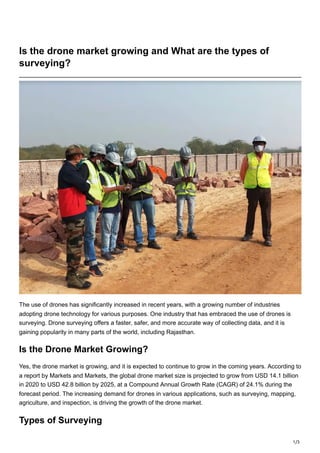
- 1. 1/3 Is the drone market growing and What are the types of surveying? The use of drones has significantly increased in recent years, with a growing number of industries adopting drone technology for various purposes. One industry that has embraced the use of drones is surveying. Drone surveying offers a faster, safer, and more accurate way of collecting data, and it is gaining popularity in many parts of the world, including Rajasthan. Is the Drone Market Growing? Yes, the drone market is growing, and it is expected to continue to grow in the coming years. According to a report by Markets and Markets, the global drone market size is projected to grow from USD 14.1 billion in 2020 to USD 42.8 billion by 2025, at a Compound Annual Growth Rate (CAGR) of 24.1% during the forecast period. The increasing demand for drones in various applications, such as surveying, mapping, agriculture, and inspection, is driving the growth of the drone market. Types of Surveying
- 2. 2/3 Surveying is the process of collecting data about the earth's surface to create maps and 3D models. There are various types of surveying, including: 1. Topographic Surveying: This type of surveying is used to map the physical features of a land area, such as hills, valleys, and bodies of water. Topographic surveying is used in various applications, such as urban planning, environmental assessment, and civil engineering. 2. Construction Surveying: Construction surveying is used to determine the location, elevation, and orientation of buildings, roads, and other infrastructure projects. Construction surveying is essential for ensuring that buildings and infrastructure are constructed correctly and safely. 3. Boundary Surveying: Boundary surveying is used to establish property lines and boundaries. This type of surveying is often required when buying or selling property or when resolving disputes over property ownership. 4. Aerial Surveying: Aerial surveying involves using aircraft, such as drones or planes, to collect data about the earth's surface. Aerial surveying is often used in large-scale projects, such as mapping entire cities or tracking changes in natural resources over time. Drone Survey in Rajasthan
- 3. 3/3 Rajasthan is a state in northern India known for its historic landmarks and stunning landscapes. Drone surveying is gaining popularity in Rajasthan as it offers a faster, safer, and more accurate way of collecting data about the state's geography and infrastructure. One of the most common applications of drone surveying in Rajasthan is in the field of construction. Drones can be used to create 3D models of construction sites, which can help architects and engineers visualize the project and identify potential issues before construction begins. Drones can also be used to monitor construction progress and ensure that the project is on schedule and on budget. Another application of drone survey in Rajasthan is in the field of agriculture. Drones can be used to collect data about crops, such as their health, growth rate, and moisture levels. This information can be used to make informed decisions about planting, fertilizing, and harvesting, which can increase crop yields and reduce waste. Conclusion Drone surveying is a growing industry, and it is expected to continue to grow in the coming years. The use of drones in surveying offers many advantages over traditional surveying methods, including increased accuracy, speed, and safety. In Rajasthan, drone surveying is being used in various applications, such as construction and agriculture, to collect data about the state's geography and infrastructure. As drone technology continues to improve, we can expect to see even more applications of drone surveying in Rajasthan and around the world. Business Name- Garud Survey Private Limited Business Address- 108 MIIC, Near MNIT Campus, JLN Marg, Jaipur, Raj. Business Number- 7733911999