What is surveying and What is the difference between drones and UAVs (Unmanned Aerial Vehicles).pdf
•
0 likes•2 views

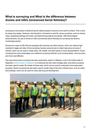
One area where drone surveying has been particularly useful is in Bikaner, a city in the Indian state of Rajasthan. Drone Survey in Rajasthan is a historical city with many heritage sites, and drone surveying has been used to create 3D models of these sites, which can be used for restoration and preservation purposes. Drone surveying has also been used to create maps of the city’s infrastructure, such as roads and buildings, which can be used for urban planning and development.

Recommended
Recommended
More Related Content
Similar to What is surveying and What is the difference between drones and UAVs (Unmanned Aerial Vehicles).pdf
Similar to What is surveying and What is the difference between drones and UAVs (Unmanned Aerial Vehicles).pdf (20)
More from Garud Survey Private Limited
More from Garud Survey Private Limited (8)
Recently uploaded
Recently uploaded (20)
What is surveying and What is the difference between drones and UAVs (Unmanned Aerial Vehicles).pdf
- 1. 1/2 What is surveying and What is the difference between drones and UAVs (Unmanned Aerial Vehicles)? Surveying is the process of determining the relative position of points on the earth’s surface. This is done by measuring angles, distances, and elevations. Surveying is used for various purposes, such as making maps, designing buildings and roads, and determining property boundaries. With technological advancements, the use of drones or UAVs (Unmanned Aerial Vehicles) for surveying has become increasingly popular. Drones are a type of UAV that are equipped with cameras and other sensors, which can capture high- resolution images and data. Drone surveying involves using drones to collect data about an area of interest, which can be used to create maps, 3D models, and other types of visual representations. Drone surveying has many advantages over traditional surveying methods, such as being faster, more accurate, and more cost-effective. One area where drone surveying has been particularly useful is in Bikaner, a city in the Indian state of Rajasthan. Drone Survey in Rajasthan is a historical city with many heritage sites, and drone surveying has been used to create 3D models of these sites, which can be used for restoration and preservation purposes. Drone surveying has also been used to create maps of the city’s infrastructure, such as roads and buildings, which can be used for urban planning and development.
- 2. 2/2 While drones and UAVs are often used interchangeably, there is a slight difference between the two. UAVs are unmanned aircraft that are used for various purposes, such as surveillance, delivery, and transportation. Drones, on the other hand, are a specific type of UAV that are designed for recreational or commercial use. Drones are equipped with cameras and other sensors, which can be used for photography, videography, and data collection. In terms of surveying, both drones and UAVs can be used, but drones are more commonly used due to their size, agility, and cost-effectiveness. UAVs are typically larger and more expensive than drones, which makes them less suitable for surveying applications. In conclusion, surveying is an important process that is used for various purposes, such as mapping, designing, and determining property boundaries. With the advent of technology, drone surveying has become increasingly popular due to its accuracy, speed, and cost-effectiveness. Drone Survey & Aerial Inspection, drone surveying has been used to create 3D models of heritage sites and maps of the city’s infrastructure, which can be used for restoration, preservation, and urban planning purposes. While drones and UAVs are often used interchangeably, drones are more commonly used for surveying applications due to their size and cost-effectiveness. Business Name– Garud Survey Private Limited Business Address- 108 MIIC, Near MNIT Campus, JLN Marg, Jaipur, Raj. Business Number- 7733911999