
Recommended
More Related Content
What's hot
What's hot (20)
Similar to Summative assessment 1 week 1 (final)
Similar to Summative assessment 1 week 1 (final) (20)
Recently uploaded
Recently uploaded (20)
Summative assessment 1 week 1 (final)
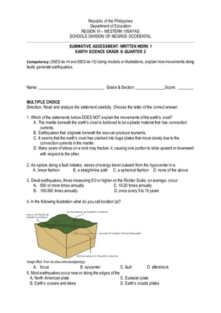
- 1. Republic of the Philippines Department of Education REGION VI – WESTERN VISAYAS SCHOOLS DIVISION OF NEGROS OCCIDENTAL SUMMATIVE ASSESSMENT- WRITTEN WORK 1 EARTH SCIENCE GRADE 8- QUARTER 2 Competency:(S8ES-IIa-14 andS8ES-IIa-15) Using models or illustrations, explain how movements along faults generate earthquakes. Name: _________________________________ Grade & Section: _______________Score: ________ MULTIPLE CHOICE Direction. Read and analyze the statement carefully. Choose the letter of the correct answer. 1. Which ofthe statements below DOES NOT explain the movements ofthe earth’s crust? A. The mantle beneath the earth’s crust is believed to be a plastic material that has convection currents. B. Earthquakes that originate beneath the sea can produce tsunamis. C. It seems that the earth’s crust has cracked into huge plates that move slowly due to the convection currents in the mantle. D. Many years ofstress on a rock may fracture it, causing one portion to slide upward or downward with respectto the other. 2. As rupture along a fault initiates, waves ofenergy travel outward from the hypocenter in a: A. linear fashion B. a straight-line path C. a spherical fashion D. none of the above 3. Great earthquakes, those measuring 8.0 or higher on the Richter Scale, on average, occur A. 500 or more times annually C. 10-20 times annually B. 100-300 times annually D. once every 5 to 10 years 4. In the following illustration what do you call location (a)? Image lifted from sci.sdsu.edu/visualgeology A. focus B. epicenter C. fault D. aftershock 5. Mostearthquakes occur near or along the edges ofthe A. North American plate C. Eurasian plate B. Earth’s oceans and lakes D. Earth’s crustal plates
- 2. Republic of the Philippines Department of Education REGION VI – WESTERN VISAYAS SCHOOLS DIVISION OF NEGROS OCCIDENTAL SUMMATIVE ASSESSMENT- WRITTEN WORK 1 EARTH SCIENCE GRADE 8- QUARTER 2 6. The San Andreas Fault zone has formed where the edge ofthe Pacific plate is slipping A. under the North American plate C. south along the North American plate B. over the North American plate D. north along the North American plate 7. Which ofthe following provides evidence for plate tectonics? A. sea-floor topography C. ocean currents B. Coriolis effect D. atmospheric temperatures 8. The convergence oftwo continental plates would produce A. island arcs. B. rift valleys. C. folded mountains. D. trenches. 9. ________are defined as free falling fragments of rocks from steep cliffs or slopes. A. Rockfalls B. Toppling C. Debris avalanche D. Earthflow 10. A force that acts on a rock to change its shape or volume is called A. stress. B. folding. C. faulting. D. liquefaction. 11. Mountain formation is known as orogenesis. Mountains can be formed through: A. folding B. faulting C. both A & B D. none ofthe above 12. Which stress force pulls on the crust and stretches rock? A. shearing B. tension C. liquefaction D. compression 13. What process occurs when an earthquake’s shaking turns loose soil into mud? A. deformation B. shearing C. liquefaction D. base-isolation 14. The type ofstress force that produces a strike-slip faultis A. compression. B. shearing. C. tension. D. liquefaction. 15. What type offault forms when the hanging wall moves upward pastthe footwall? A. normal fault C. strike-slip fault B. fault-block mountain D. reverse fault 16. A surface or narrow zone along which one side has moved relative to the other is called a/an__. A. Fault B. Fold C. Indentation D. Uplift 17. In which tectonic environment, can you find the surface expression in the form of folding? A. Extensional B. Compressional C. Strike slip D. All of these 18. The San Andreas Fault is an example of: A. Normal fault C. Right lateral strike slip B. Reverse fault D. Left lateral strike slip 19. Which is the largestsubduction earthquake? A.1960 Chile earthquake C. 2011 Tohuku earthquake B. 1905 Kangra earthquake D. 2004 Sumatra-Andaman earthquake 20. Surface along which the block ofrock slips is called _____? A. Fault zone B. Fault Plane C. Fault scarp D. None ofthes
- 3. Republic of the Philippines Department of Education REGION VI – WESTERN VISAYAS SCHOOLS DIVISION OF NEGROS OCCIDENTAL SUMMATIVE ASSESSMENT- WRITTEN WORK 1 EARTH SCIENCE GRADE 8- QUARTER 2 KEY ANSWER 1B 5D 9A 13C 17B 2C 6D 10A 14B 18C 3C 7A 11C 15D 19A 4B 8C 12B 16A 20B
- 4. Republic of the Philippines Department of Education REGION VI – WESTERN VISAYAS SCHOOLS DIVISION OF NEGROS OCCIDENTAL SUMMATIVE ASSESSMENT- WRITTEN WORK 1 EARTH SCIENCE GRADE 8- QUARTER 2 TABLE OF SPECIFICATION Most Essential Learning Competencies Number of Days Percentage Number of Items Item Location Easy (60%) Average (30%) Difficult (10%) Re me mb er Und erst and A p pl y Ana lyze Eva luat e Cre ate Using models or illustrations, explain how movements along faults generate earthquakes. (S8ES-IIa-14) Describe the appearance of a fault and how it is formed. 1.5 30% 6 4,17 15 16 20 6 Explain how faults generate earthquakes 2 40% 8 1,10, 11, 12, 14 5 18 19 Explain the effectof bending ofrocks along faults. 1.5 30% 6 13, 9 2, 7 3 8 Total 5 100% 20 9 4 2 3 2