SlideShare a Scribd company logo
1 of 48
2. Urban Transportation, Urban Form and Land Use
2.1 Transportation and Urban form
2.1.1 Urbanization
• Urbanization. The process of transition from a rural to a more urban
society.
• The level of urbanization is the percentage of the total population living in
towns and cities while the rate of urbanization is the rate at which it
grows.
• Urban mobility problems have increased proportionally with urbanization,
a trend reflected in the growing size of cities and in the increasing
proportion of the urbanized population due to two main demographic
trends:
• Natural increase. It is simply the outcome of more births than deaths in
urban areas, a direct function of the fertility rate as well as the quality of
healthcare systems.
• Rural to urban migrations. This has been a strong factor of urbanization,
particularly in the developing world where migration accounted between
40 and 60% of the urban growth.
• The reasons for urban migration are numerous and may involve the
expectation to find employment, improved agricultural productivity which
frees rural labor or even political and environmental problems where
populations are constrained to leave the countryside.
2.1.2 The Urban Form
• At the urban level, demographic and mobility growth
have been shaped by the capacity and requirements
of urban transport infrastructures: roads, transit
systems or simply walkways. Consequently, there is
a wide variety of urban forms, spatial structures and
associated urban transportation systems.
• Urban form. Refers to the spatial imprint of an
urban transport system as well as the adjacent
physical infrastructures. Jointly, they confer a level
of spatial arrangement to cities.
• Urban (spatial) structure. Refers to the set of
relationships arising out of the urban form and its
underlying interactions of people, freight and
information.
Infrastructures
Modes
Users
Transportation, Urban Form and Spatial Structure
Transportation Urban Form
Spatial
imprint
Urban Spatial Structure
Spatial
interaction
Elements of the urban transport system - modes, infrastructures and users - have a spatial
imprint which shapes the urban form. Considering that each city has different socioeconomic and
geographical characteristics, the spatial imprint of transportation varies accordingly. For instance,
while North American cities tend to have an urban form that has been shaped by the automobile,
cities in other parts of the world, because of different modal preferences and infrastructure
developments, have different urban forms. The urban transport system is also composed of spatial
interactions reflecting its spatial structure.
2.1.2 The Urban Form
• Even if the geographical setting of each city varies considerably,
the urban form and its spatial structure are articulated by two
structural elements:
• Nodes. These are reflected in the centrality of urban activities,
which can be related to the spatial accumulation of economic
activities or to the accessibility to the transport system. Terminals,
such as ports, railyards, and airports, are important nodes around
which activities agglomerate at the local or regional level. Nodes
have a hierarchy related to their importance and contribution to
urban functions, such as production, management, retailing and
distribution.
• Linkages. These are the infrastructures supporting flows from, to
and between nodes. The lowest level of linkages includes streets,
which are the defining elements of the urban spatial structure.
There is a hierarchy of linkages moving up to regional roads and
railways and international connections by air and maritime
transport systems.
2.1.2 The Urban Form
Nodes, Linkages and Urban Form
• Two basic forms of interdependent nodes are at the core of the
urban spatial structure:
• Accessibility nodes. Refer to locations that transfer passengers
and freight, thus offering accessibility to resources and markets
within and/or outside the urban area. They include terminals
such as ports, rail stations, airports and distribution centers.
• Economic nodes. Refer to locations that perform a function of
economic significance. These functions are extremely varied and
can include administration, education, retailing and leisure.
Economic nodes tend to agglomerate, or to cluster, and are often
dependent on access to an accessibility node or a linkage. Such
clusters often take the form of central business districts or
industrial districts.
• The presence of nodes requires linkages, which can be serviced
by different transport modes. Road and transit linkages are
obviously local in scope often taking the form of a grid that
characterizes the form of many cities, while rail, maritime and air
linkages integrate the city to a wider context of distribution and
trade. The complex set of relationships between nodes and their
linkages imply an urban form which is unique in each case.
The relationships between Nodes, Linkages and
Urban Form
Accessibility node
Economic node
Built area Road / transit
linkage
Rail linkage
Maritime linkage
Air linkage
CBD
Port
District
Manufacturing
District
2.1.2 The Urban Form
• Urban transportation is organized in three broad categories of
collective, individual and freight transportation.
• Collective Transportation (public transit). The purpose of collective
transportation is to provide publicly accessible mobility over specific
parts of a city. Its efficiency is based upon transporting large
numbers of people and achieving economies of scale. It includes
modes such as tramways, buses, trains, subways and ferryboats.
• Individual Transportation. Includes any mode where mobility is the
outcome of a personal choice and means such as the automobile,
walking, cycling and the motorcycle. The majority of people walk to
satisfy their basic mobility, but this number varies according to the
city considered. For instance, walking account for 88% of all
movements inside Tokyo while this figure is only 3% for Los Angeles.
• Freight Transportation. As cities are dominant centers of production
and consumption, urban activities are accompanied by large
movements of freight. These movements are mostly characterized
by delivery trucks moving between industries, distribution centers,
warehouses and retail activities as well as from major terminals such
as ports, railyards, distribution centers and airports.
2.1.2 The Urban Form
• Historically, movements within cities tended to be
restricted to walking, which made medium and long
distance urban linkages. This mode is rather
inefficient and time-consuming.
• Thus, activity nodes tended to be agglomerated and
urban forms compact. Many modern cities have
inherited an urban form created under such
circumstances.
• The dense urban cores of many European, Japanese
and Chinese cities, for example, enable residents to
make between one third and two thirds of all trips by
walking and cycling.
• At the other end of the spectrum, the dispersed
urban forms of most Australian, Canadian and
American cities, which were built recently,
encourages automobile dependency and are linked
with high levels of mobility.
2.1.2 The Urban Form
Relationship between space, travel time and different
Urban Transportation Modes
• For a commuter, the relationship between space and travel time changes
dramatically with the transportation mode used:
• Walking. Assuming a willingness to commute for one hour, a pedestrian walking at 5
km per hour could cross about 5 km. The space / time relationship of such a
commute would be a circle of 10 km of diameter.
• Streetcar. A streetcar, like those operating in the first half of the 20th century, could
travel around 15 km per hour along fixed lines. In this case, the space / time
relationship would be star shaped to reflect walking to the streetcar line and of 15 km
of diameter along the lines.
• Cycling. The bicycle became a mode of mass transportation in the late 19th and
early 20th centuries. With approximately the same speed of a streetcar, but with no
fixed line limitations, the space / time relationship of commuting by bicycle would be
a circle of 15 km of diameter.
• Driving (no freeways). With a driving speed of about 30 km per hour (taking into
account of stops, lights, congestion and parking), an automobile creates a spherical
space / time relationship of about 30 km in diameter.
• Driving (with freeways). Along a freeway, a fixed infrastructure, the driving speed is
doubled to 60 km per hour. The space / time relationship is then star shaped with 60
km of diameter along its axis.
• Obviously, the real world is much more complex than the theoretical example
portrayed here. However, these mode / space relationships apply to anyone
commuting.
One Hour Commuting According to Different
Urban Transportation Modes
Streetcar line
Freeway
Walking
Streetcar
Cycling
Automobile
Automobile with
freeways
10 km
Evolution of AA and surrounding
towns
2.1.3. Evolution Of Transportation And Urban Form
• The evolution of transportation has generally led to changes in urban
form. The more radical the changes in transport technology, the more
the urban form has been altered.
• Among the most fundamental changes in urban form is the
emergence of new clusters expressing new urban activities and new
relationships between elements of the urban system.
• In many cities, the central business district (CBD), once the primary
destination of commuters and serviced by public transportation, has
been changed by new manufacturing, retailing and management
practices.
• Whereas traditional manufacturing depended on centralized
workplaces and transportation, technological and transportation
developments rendered modern industry more flexible.
• In many cases, manufacturing relocated in a suburban setting, if not
altogether to entirely new low costs locations.
• Retail and office activities are also suburbanizing, producing changes
in the urban form.
• Concomitantly, many important transport terminals, namely port
facilities and railyards, have emerged in suburban areas following new
requirements in modern freight distribution.
2.1.3. Evolution Of Transportation And
Urban Form
• From the 1950s, the growth of suburbs was mainly taking
place adjacent to major road corridors, leaving a lot of
vacant or farm land in between. Later, intermediate spaces
were gradually filled up, more or less coherently.
• Highways and ring roads, which circled and radiated from
cities, favored the development of suburbs and the
emergence of important sub-centers that compete with the
central business district for the attraction of economic
activities.
• As a result, many new job opportunities have shifted to the
suburbs (if not to entirely new locations) and the activity
system of cities has been considerably modified.
• Different parts of a city have different dynamism depending
on its spatial pattern. These changes have occurred
according to the variety of geographical and historical
contexts.
2.1.3. Evolution Of Transportation And Urban
Form
Evolution of the Spatial Structure of a City
• The urban spatial structure basically considers the location of
different activities as well as their relationships.
• Core activities are those of the highest order in the urban spatial
structure, namely tertiary and quaternary activities involved in
management (finance and insurance) and consumption (retailing).
• Central activities are concerned by production and distribution
with activities such as warehousing, manufacturing, wholesaling
and transportation.
• Peripheral activities are dominantly residential or servicing local
needs.
• A central area refers to an agglomeration of core and/or central
activities within a specific location. The emergence of a CBD
(Central Business District; the central area of a city) is the result of
an historical process, often occurring over several centuries
(depending on the age of a city), that has changed the urban form
and the location of economic activities.
A B C
Core activities
Central activities
Peripheral activities
Evolution of the Spatial Structure of a City
Central area
Major transport axis
(A) Pre
industrial era.
(B) Industrial revolution.
(C) Contemporary era.
2.1.3. Evolution Of Transportation And
Urban Form
• Obviously, each city has its own history, but it is possible to establish a general
common process:
• (A) Pre industrial era. For cities that existed before the industrial revolution, the
CBD was limited to small section of the city generally nearby the waterfront, the
market and/or a site of religious or political importance. These were locations
where major transactions took place and thus required financial, insurance,
warehousing and wholesale services.
• (B) Industrial revolution. With the industrial revolution came mass production and
mass consumption. This permitted the emergence of a distinct retailing and
wholesaling part of the CBD while manufacturing located outside the core.
Managing these expanding activities also created an increasing need for office
space that located nearby traditional places of financial interaction. As the
industrial revolution matured, major transportation axis spurred from the central
area towards the periphery.
• (C) Contemporary era. In the contemporary era, industries massively relocated
away from the CBD to suburban areas, leaving room to the expansion of
administrative and financial activities. The CBD was thus the object of an
important accumulation of financial and administrative activities, particularly in
the largest cities as several corporations became multinational enterprises.
These activities were even more willing to pay higher rents than retailing, thereby
pushing some retail activities out of the CBD. New retailing sub-centers emerged
in suburban areas because of road accessibility and because of the needs to
service these new areas. Warehousing and transportation, no longer core area
activities, have also relocated to new peripheral locations.
2.1.3. Evolution Of Transportation And
Urban Form
Two processes have a substantial impact on contemporary urban
forms:
• Dispersed urban land development patterns have been dominant in
North America over the last 50 years, where land is abundant,
transportation costs are low, and the economy has become
dominated by service and technology industries. Under such
circumstances, it is not surprising to find that there is a strong
relationship between urban density and automobile use. For many
cities their built up areas have grown at a faster rate than their
populations. In addition, commuting has become relatively
inexpensive compared with land costs, so households have an
incentive to buy lower-priced housing at the urban periphery. Similar
patterns can be found in many European cities, but this change is
occurring at a lower pace and involving a smaller range.
• The decentralization of activities resulted in two opposite
effects. First, commuting time has remained relatively stable in
duration. Second, commuting increasingly tends to be longer and
made using the automobile rather than by public transit. Most transit
and road systems were developed to facilitate suburb-to-city, rather
than suburb-to-suburb, commuting. As a result, suburban highways
are often as congested as urban highways.
2.1.3. Evolution Of Transportation And
Urban Form
• Although transportation systems and travel patterns
have changed considerably over time, one enduring
feature remains that most people travel between 30-
40 minutes in one direction.
• Globally, people are spending about 1.2 hours per
day commuting, wherever this takes place in a low or
a high mobility setting.
• Different transport technologies, however, are
associated with different travel speeds and capacity.
As a result, cities that rely primarily on non-motorized
transport tend to be different than auto-dependent
cities.
• Transport technology thus plays a very important role
in defining urban form and the spatial pattern of
various activities.
Possible Urban Movement Patterns
Monocentric Polycentric
Organized
Disorganized
Primary flow Secondary flow
Cities with a
higher level of
reliance on
public transit
tend to be
monocentric
and have a
higher level of
organized
flows while
cities
depending
more on the
automobile
tend to be
polycentric
and have a
more
disorganized
structure of
flows.
Possible
Urban
Movement
Patterns
Cities can
structurally
classified as
polycentric
(more
common) or
monocentric
and major
flows as
organized or
disorganized
(more
common).
2.1.4 The Spatial Imprint Of Urban Transportation
• The amount of urban land allocated to
transportation is often correlated with the level of
mobility.
• In the pre-automobile era, about 10% of the
urban land was devoted to transportation which
were simply roads for a traffic that was
dominantly pedestrian.
• As the mobility of people and freight increased,
a growing share of urban areas is allocated to
transport and the infrastructures supporting it.
• Large variations in the spatial imprint of urban
transportation are observed between different
cities as well as between different parts of a city,
such as between central and peripheral areas.
Urban Form, Hempstead, Long Island, New York
Road (11.9%)
Parking (21.8%)
Building (5.3%)
Other (61.0%)
•This spatial
structure is quite
representative of
a car dependent
neighborhood in
the United States.
Roads and off-
street parking
lots jointly
account for
33.7% of the total
area, while built
up areas account
for only 5.4%.
This figure is
actually higher as
the numerous
residential
driveways are not
accounted for.
2.1.4 The Spatial Imprint Of Urban Transportation
• The major components of the spatial imprint of urban
transportation are:
• Pedestrian areas. Refer to the amount of space devoted to
walking. This space is often shared with roads as sidewalks
may use between 10% and 20% of a road's right of way. In
central areas, pedestrian areas tend to use a greater share of
the right of way and in some instances, whole areas are
reserved for pedestrians. However, in a motorized context,
most of pedestrian areas are for servicing people's access to
transport modes such as parked automobiles.
• Roads and parking areas. Refer to the amount of space
devoted to road transportation, which has two states of
activity; moving or parked. In a motorized city, on average
30% of the surface is devoted to roads while another 20% is
required for off-street parking. This implies for each car about
2 off-street and 2 on-street parking spaces. In North American
cities, roads and parking lots account between 30 to 60% of
the total surface. In Western Europe, roads account for
between 15% and 20% of the urban surface while for
developing countries, this figure is about 10% (6% on average
2.1.4 The Spatial Imprint Of Urban Transportation
• The spatial importance of each transport mode varies according to
a number of factors, density being the most important.
• If density is considered as a gradient, rings of mobility represent
variations in the spatial importance of each mode at providing urban
mobility.
• Further, each transport mode has unique performance and space
consumption characteristics.
• The most relevant example is the automobile. It requires space to
move around (roads) but it also spends 98% of its existence
stationary in a parking space. Consequently, a significant amount of
urban space must be allocated to accommodate the automobile,
especially when it does not move and is thus economically and
socially useless.
• At an aggregate level, measures reveal a significant spatial imprint
of road transportation among developed countries. In the United
States, more land is thus used by the automobile than for housing.
2.1.4 The Spatial Imprint Of Urban Transportation
• Cycling areas. In a disorganized form, cycling simply shares access to
pedestrian and road space. However, many attempts have been made
to create spaces specifically for bicycles in urban areas, with reserved
lanes and parking facilities.
• Transit systems. Many transit systems, such as buses and tramways,
share road space with automobiles, which often impairs their respective
efficiency. Attempts to mitigate congestion have resulted in the creation
of road lanes reserved to buses either on a permanent or temporary
(during rush hour) basis. Other transport systems such as subways and
rail have their own infrastructures and, consequently, their own rights of
way.
• Transport terminals. Refer to the amount of space devoted to terminal
facilities such as ports, airports, transit stations, railyards and
distribution centers. Globalization has increased the mobility of people
and freight, both in relative and absolute terms, and consequently the
amount of urban space required to support those activities. Many major
terminals are located in the peripheral areas of cities, which are the only
locations where sufficient amounts of land are available.
2.1.4 The Spatial Imprint Of Urban Transportation
Rings of Mobility
• The preponderance of each mode in the spatial imprint of urban transportation as a
support to urban mobility is dominantly related to density. The above figure shows
three rings of increased density, each characterized by specific mobility
considerations:
• A (Core area). Often related to a CBD representing the optimum level of urban density
and centrality. In such a context, the pedestrian space is dominant as most origins and
destinations are close by. Sidewalks tend to be substantial and where the conditions
are favorable, a system of overpasses and pedestrian-only streets have been
established. This area is often the point of convergence of the regional passenger
transport system, implying the presence of transit systems and their associated
terminal spaces. The handhold of the road space is mainly attributed to a pattern of
streets supporting local circulation.
• B (Central area). Represents areas of medium to high densities, often adjacent to
core areas. The walking space has lost some of its importance but still support mobility
around major nodes (transit stations) and corridors (commercial streets). Commercial
terminals, mainly rail freight yards and old port facilities, are also occupying substantial
amounts of space.
• C (Peripheral / suburban area). Mobility is dominantly provided by road
transportation with walking and cycling servicing residual functions, often leisure-
oriented. Space consuming terminal activities, such as airport and modern -
containerized- port facilities occupy significant amounts of land.
Rings of Mobility
Pedestrian
Road and parking
Cycling
Transit
Terminal
Density
A
B
C
2.1.5 Transportation And Urban Structure
• Rapid and expanded urbanization occurring around the world involves
an increased numbers of trips in urban areas. Cities have traditionally
responded to growth in mobility by expanding the transportation
supply, by building new highways and/or transit lines. In the
developed world, that has mainly meant building more roads to
accommodate an ever-growing number of vehicles, therefore creating
new urban structures. Several urban spatial structures have
accordingly emerged, with the reliance on the automobile being the
most important discriminatory factor. Four major types can be
identified at the metropolitan scale:
• Type I - Completely Motorized Network: Representing an automobile-
dependent city with a limited centrality.
• Type II - Weak Center: Representing the spatial structure of many
American cities where many activities are located in the periphery.
• Type III - Strong Center: Representing high density urban centers with
well developed public transit systems, particularly in Europe and Asia.
• Type IV - Traffic Limitation. Representing urban areas that have
implemented traffic control and modal preference in their spatial
structure. Commonly, the central area is dominated by public transit.
Type I - Completely Motorized Network
• Characterized by low to average land use densities, this
automobile-oriented city assumes free movements between all
locations.
• Public transit has a residual function while a significant share of
the city is occupied by structures servicing the automobile,
notably highways and large parking lots.
• Most activities are designed to be accessed with an automobile.
This type of urban structure requires a massive network of high
capacity highways to the point that urban efficiency is based on
individual transportation.
• Secondary road converges at highways, along which small
centers are located, notably nearby interchanges.
• This system characterizes recent cities in a North American
context where urban growth occurred in the second half of the
twentieth century, such as Los Angeles, Phoenix, Denver and
Main Road Highway Activity center
Type I - Completely Motorized Network
Type II - Weak Center
• These cities are characterized by average land use densities and a
concentric pattern.
• The central business district is relatively accessible by the automobile
and is the point of convergence of the transit system, which tend to be
under-used and requiring subsidies.
• The urban area cannot be cost effectively serviced with the transit
system, so services are often oriented along major corridors.
• In many cases, ring roads favored the emergence of a set of small
centers at the periphery, notably at the convergence of radial lines, some
of them effectively competing with the central business district for the
location of economic activities.
• This system is often related to older cities, which emerged in the first half
of the twentieth century, such as Melbourne, San Francisco, Boston,
Chicago and Montreal, and were afterwards substantially impacted by
motorization.
Main Road Highway Activity center
Transit line
Type II - Weak Center
Type III - Strong Center
• Characterizes cities having a high land use density
and high levels of accessibility to urban transit. There
are thus limited needs for highways and parking space
in the central area, where a set of high capacity public
transit lines are servicing most of the mobility needs.
• The productivity of this urban area is thus mainly
related to the efficiency of the public transport system.
• The convergence of radial roads and ring roads favors
the location of secondary centers, where activities that
could no longer able to afford a central location
converge.
• This system characterizes cities having important
commercial and financial functions and having grown
in the 19th century, such as Paris, New York,
Shanghai, Toronto, Sydney and Hamburg.
Main Road Highway Activity center
Transit line
Type III - Strong Center
Type IV - Traffic Limitation
• Represents urban areas that have efficiently implemented traffic
control and modal preference in their spatial structure.
• Commonly, the central area is dominated by public transit.
• They have a high land use density and were planned to limit the
usage of the automobile in central areas for a variety of reasons, such
as to preserve its historical character or to avoid congestion.
• Public transit is used in central areas, while individual transportation
takes a greater importance in the periphery.
• Between suburbs and the central city are places of interface between
individual (automobile) and collective transportation or between low
capacity collective transportation (bus) and high capacity collective
transportation (metro, rail).
• Several cities are implementing this strategy, namely through
congestion pricing, as it keeps cars from the central areas while
supporting the bulk of the mobility in the suburbs.
• This system typifies cities having a long planning history favoring
public transit, particularly in socialist economies. London, Singapore,
Hong Kong, Vienna and Stockholm are good examples of this urban
transport structure.
Type IV - Traffic Limitation
Main Road Highway Activity center
Transit line
2.1.5 Transportation And Urban Structure
Scale and Urban Spatial Structure
• There are different scales where transportation systems
influence the structure of communities, districts and the
whole metropolitan area. For instance, one of the most
significant impacts of transportation on the urban structure
has been the clustering of activities near areas of high
accessibility.
• At the community level, the urban spatial structure is
influenced by the street patterns and the location of
residences and basic services.
• At the district level, which can be seen as a conglomeration
of various communities, the urban spatial structure is
influenced by main roads and specific employment zones.
• At the city level, highway, transit systems and major
transport terminals are the dominant elements impacting the
spatial structure.
Scale and Urban Spatial Structure
City
District
Community
• Highway and transit systems
• Major transport terminals
(ports and airports)
• Streets
• Basic services
• Residences
• Main roads
• Employment zones
Scale Components of the
spatial structure
2.1.5 Transportation And Urban Structure
Ring Roads
• Facing the expansion of urban areas, congestion problems and
the increasing importance of inter-urban movements, several
ring roads have been built around major cities.
The Rationale of a Ring Road
• The impact of ring roads on the spatial structure is favoring a
radial pattern and the development of commercial, residential
and industrial activities nearby highway interchanges.
• The decreasing dynamism of central areas is often linked with
the emergence of centers at the periphery.
• Ring roads also improves accessibility within a metropolitan
area, especially at the periphery.
• As indicated in the next figure, prior to the construction of a ring
road, going from point A to point B would take 30 minutes,
with delays mainly imposed by having to go through the central
area.
• Once a ring right has been established, travel time between
point A and point B is reduced to 20 minutes.
Secondary
Center
City
Center
Avoiding the congested
central area
Structuring
Suburban
development
The Rationale of a Ring Road
Spatial Structure Accessibility
5
10
10
5
5
10
10
5
A B
A to B = 30
A B
5
10
10
5
5
10
10
5
10 10
10
10
A to B = 20
Before
After
2.2. Transportation and Urban Land Use
2.2.1 The Land Use - Transport System
• Urban land use comprises two elements; the nature of land
use which relates to which activities are taking place where,
and the level of spatial accumulation, which indicates their
intensity and concentration.
• Central areas have a high level of spatial accumulation and
corresponding land uses while peripheral areas have lower
levels of accumulation.
• Most economic, social or cultural activities imply a multitude of
functions, such as production, consumption and distribution.
These functions take place at specific locations and are part of
an activity system.
• Activities have spatial locations creating a land use pattern,
which is influenced by the existing urban form and spatial
structure.
2.2.1 The Land Use - Transport System
• Land use form is strongly related to the types of activities that can roughly be
divided in to three major classes:
• Routine Activities. This class of activities is occurring regularly and is thus
predictable. They involve journey to work (residential to industrial / commercial /
administrative) and shopping (residential to retailing). The land use pattern
generated is thus stable and coherent. Generally, these activities are zonal and
links are from areas to areas.
• Institutional Activities. Most institutions are located at specific points and
generally have links with individuals. This activity system is linked to an urban
environment where links are occurring irregularly and according to the lifestyle
(students, sports, leisure, etc.) or special needs (health).
• Production Activities. This involves a complex network of relationships
between firms, such as distribution, warehousing etc. This activity system can be
linked to a specific urban environment, but also to a region, nation, or even the
world. Some activities are strongly linked to the local urban area, while others are
far more linked to the global economy. The land use pattern of an activity may
thus be linked to an external (international) process.
• These activity systems underline the importance of linkages between land
uses, which require movements of people, freight and information. The results
of these linkages are land use patterns.
• Thus, understanding the set of relationships an industrial district has with its
labor, suppliers and customers will provide an overview of the land use patterns
in an urban area, but also with other urban areas.
The Land Use - Transport System
• Urban transportation aims at supporting transport demands
generated by the diversity of urban activities in a diversity of urban
contexts.
• A key for understanding urban entities thus lies in the analysis of
patterns and processes of the transport / land use system. This
system involves several relationships between the transport
system, spatial interactions and land use:
• Transport system. Considers the set of transport
infrastructures and modes that are supporting urban
movements of passengers and freight. It generally expresses
the level of accessibility.
• Spatial interactions. Consider the nature, extent, origins and
destinations of the urban movements of passengers and freight.
They take into consideration the attributes of the transport system
as well as the land use factors that are generating and attracting
movements.
• Land use. Considers the level of spatial accumulation of
activities and their associated levels of mobility
requirements. Land use is commonly linked with demographic
and economic attributes.
Infrastructures
Modes
Users
Transportation, Activity Systems and Land Use
Transportation Urban Form
Spatial
imprint
Urban Spatial Structure
Spatial
interaction
Labor
Customers
Suppliers
Activity
Land Use Pattern
Spatial
location
The Land Use - Transport System
• The behavioral patterns of individuals, institutions and firms
have an imprint on land use.
• The representation of this imprint requires a typology of land
use, which can be formal or functional:
• Formal land use representations are concerned with
qualitative attributes of space such as its form, pattern and
aspect and are descriptive in nature.
• Functional land use representations are concerned with the
economic nature of activities such as production, consumption,
residence, and transport, and are mainly a socioeconomic
description of space.
• The formal land use map can be created with aerial or remote
sensing images, but it is very difficult to infer any functional
attributes from these observations, especially for urban land
use.
• The functional land use map requires an implicit knowledge of
the functional attributes of an area, commonly gained through
field observations.
Formal and Functional Land Use
Road
Parking
Building
Other
Formal Land Use Functional Land Use Road
Parking
Residential
Other
Commercial
Institutional
Industrial
The above maps represent the land uses of the same neighborhood, classified formally (left)
and functionally (right). Under such circumstances, land use that has been formally classified
as building (built up) can be functionally described as residential, commercial, institutional or
industrial.
Transport Infrastructure and
Activity Location
Freight
based
Population
based
Mixed
Mixed
Each type of urban
activity has its own
mobility requirements
that are serviced by
the urban transport
system. This figure
illustrates locational
preferences
according to urban
transport
infrastructures.
Population based
activities (e.g.
residential) are
dominant where rail
(metro and
passenger) and bus
infrastructures are
converging, while
freight based
activities (e.g.
manufacturing and
warehousing)
agglomerate nearby
high capacity road
infrastructures.
2.2.2. Transportation And Urban Dynamics
• Both land use and transportation are part of a dynamic system that is subject to
external influences. Each component of the system is constantly evolving due to
changes in technology, policy, economics, demographics and even culture/values,
among others. As a result, the interactions between land use and transportation are
played out as the outcome of the many decisions made by residents, businesses and
governments.
• The most significant components of urban dynamics are:
• Land use. This is the most stable component of urban dynamics, as changes are likely
to modify the land use structure over a rather long period of time. The main impact of
land use on urban dynamics is its function of a generator and attractor of movements.
• Transport network. This is also considered to be a rather stable component of urban
dynamics, as transport infrastructures are built for the long term. The main contribution
of the transport network to urban dynamics is the provision of accessibility. Changes in
the transport network will impact accessibility and movements.
• Movements. The most dynamic component of the system since movements of
passengers or freight reflect changes almost immediately.
• Employment and workplaces. They account for significant inducement effects over
urban dynamics since many models often consider employment as an exogenous
factor. This is specifically the case for employment that is categorized as basic, or
export oriented, which is linked with specific economic sectors such as manufacturing.
Commuting is a direct outcome of the number of jobs and the location of workplaces.
• Population and housing. They act as the generators of movements, because
residential areas are the sources of commuting.
Dynamics of Urban Change
Land Use
Network
Commuting
Freight Transport
Employment
Workplaces Housing
Population
Very Slow
Very Fast
Fast
Slow
Very Slow
Pace
of
Change

More Related Content

What's hot

Moud tod policy 29_sept 2013_secy_ud
Moud tod policy 29_sept 2013_secy_udMoud tod policy 29_sept 2013_secy_ud
Moud tod policy 29_sept 2013_secy_udUttipec Dda
 
Elements of urban design
Elements of urban designElements of urban design
Elements of urban designNeo Angala
 
Part 1 - Urban planning history, theories, and concepts
Part 1 - Urban planning history, theories, and conceptsPart 1 - Urban planning history, theories, and concepts
Part 1 - Urban planning history, theories, and conceptsEnP Ragene Andrea Palma
 
Christaller’S Central Place Theory
Christaller’S Central Place TheoryChristaller’S Central Place Theory
Christaller’S Central Place TheoryEcumene
 
Theories and Concepts of town planning
Theories and Concepts of town planningTheories and Concepts of town planning
Theories and Concepts of town planningSrishti Mehta
 
Infrastructure and Transportation Planning Study Notes
Infrastructure and Transportation Planning Study NotesInfrastructure and Transportation Planning Study Notes
Infrastructure and Transportation Planning Study NotesYash Shah
 
Contribution of compact city to urban sustainability
Contribution of compact city to urban sustainabilityContribution of compact city to urban sustainability
Contribution of compact city to urban sustainabilityNaina Gupta
 
Urban morphology, elements of urban design
Urban morphology, elements of urban designUrban morphology, elements of urban design
Urban morphology, elements of urban designAbdul Rab
 
TRANSIT ORIENTED DEVELOPMENT
TRANSIT ORIENTED DEVELOPMENTTRANSIT ORIENTED DEVELOPMENT
TRANSIT ORIENTED DEVELOPMENTRidam Shah
 
National urban transport policy
National urban transport policyNational urban transport policy
National urban transport policyShubham Jain
 
Review of Development Plans/ Master Plans of selected cities of India.
Review of Development Plans/ Master Plans of selected cities of India.Review of Development Plans/ Master Plans of selected cities of India.
Review of Development Plans/ Master Plans of selected cities of India.KARTHICK KRISHNA
 
Lesson 2 town planning concepts
Lesson  2 town planning conceptsLesson  2 town planning concepts
Lesson 2 town planning conceptsVINCENT WAN PERERA
 
Planning and Urban Management-issues & challenges
Planning and  Urban Management-issues & challenges Planning and  Urban Management-issues & challenges
Planning and Urban Management-issues & challenges Subodh Shankar
 
An introduction to urban design
An introduction to urban designAn introduction to urban design
An introduction to urban designtree63
 
Introduction to Urban Planning
Introduction to Urban PlanningIntroduction to Urban Planning
Introduction to Urban PlanningMeleseBecha2
 

What's hot (20)

New Urbanism.pptx
New Urbanism.pptxNew Urbanism.pptx
New Urbanism.pptx
 
Town planning
Town planningTown planning
Town planning
 
Moud tod policy 29_sept 2013_secy_ud
Moud tod policy 29_sept 2013_secy_udMoud tod policy 29_sept 2013_secy_ud
Moud tod policy 29_sept 2013_secy_ud
 
Elements of urban design
Elements of urban designElements of urban design
Elements of urban design
 
Part 1 - Urban planning history, theories, and concepts
Part 1 - Urban planning history, theories, and conceptsPart 1 - Urban planning history, theories, and concepts
Part 1 - Urban planning history, theories, and concepts
 
Christaller’S Central Place Theory
Christaller’S Central Place TheoryChristaller’S Central Place Theory
Christaller’S Central Place Theory
 
Theories and Concepts of town planning
Theories and Concepts of town planningTheories and Concepts of town planning
Theories and Concepts of town planning
 
Infrastructure and Transportation Planning Study Notes
Infrastructure and Transportation Planning Study NotesInfrastructure and Transportation Planning Study Notes
Infrastructure and Transportation Planning Study Notes
 
Contribution of compact city to urban sustainability
Contribution of compact city to urban sustainabilityContribution of compact city to urban sustainability
Contribution of compact city to urban sustainability
 
Urban morphology, elements of urban design
Urban morphology, elements of urban designUrban morphology, elements of urban design
Urban morphology, elements of urban design
 
TRANSIT ORIENTED DEVELOPMENT
TRANSIT ORIENTED DEVELOPMENTTRANSIT ORIENTED DEVELOPMENT
TRANSIT ORIENTED DEVELOPMENT
 
New Urbanism- Jane Jacobs
New Urbanism- Jane Jacobs New Urbanism- Jane Jacobs
New Urbanism- Jane Jacobs
 
National urban transport policy
National urban transport policyNational urban transport policy
National urban transport policy
 
Review of Development Plans/ Master Plans of selected cities of India.
Review of Development Plans/ Master Plans of selected cities of India.Review of Development Plans/ Master Plans of selected cities of India.
Review of Development Plans/ Master Plans of selected cities of India.
 
Lesson 2 town planning concepts
Lesson  2 town planning conceptsLesson  2 town planning concepts
Lesson 2 town planning concepts
 
Planning and Urban Management-issues & challenges
Planning and  Urban Management-issues & challenges Planning and  Urban Management-issues & challenges
Planning and Urban Management-issues & challenges
 
Urban & Regional Planning - Issues & Challenges
Urban & Regional Planning - Issues & ChallengesUrban & Regional Planning - Issues & Challenges
Urban & Regional Planning - Issues & Challenges
 
Image of city
Image of cityImage of city
Image of city
 
An introduction to urban design
An introduction to urban designAn introduction to urban design
An introduction to urban design
 
Introduction to Urban Planning
Introduction to Urban PlanningIntroduction to Urban Planning
Introduction to Urban Planning
 

Similar to 2. Transportation, urban form and urban land use (2).ppt

Highway & Railway Engineering
Highway & Railway EngineeringHighway & Railway Engineering
Highway & Railway EngineeringGAURAV. H .TANDON
 
Mass Transit System.pdf
Mass Transit System.pdfMass Transit System.pdf
Mass Transit System.pdfDhananjayM6
 
Social aspect of transpotr planning
Social aspect of transpotr planningSocial aspect of transpotr planning
Social aspect of transpotr planningjaganshettar
 
Future Mobility – New approaches in the city
Future Mobility – New approaches in the cityFuture Mobility – New approaches in the city
Future Mobility – New approaches in the cityhoffmann.martin
 
Transportation Engineering- 21CV52- Module 1
Transportation Engineering- 21CV52- Module 1Transportation Engineering- 21CV52- Module 1
Transportation Engineering- 21CV52- Module 1Mithesh Kumar
 
Transportation as Revitalization Strategy
Transportation as Revitalization StrategyTransportation as Revitalization Strategy
Transportation as Revitalization StrategyJohn-Mark Palacios
 
Lecture1 (1).ppt transportation engineering
Lecture1 (1).ppt transportation engineeringLecture1 (1).ppt transportation engineering
Lecture1 (1).ppt transportation engineeringhassanabdiibrahim1
 
1 roads classification
1 roads classification1 roads classification
1 roads classificationBharath Raj
 
Urban transportation planning africa
Urban transportation planning  africaUrban transportation planning  africa
Urban transportation planning africaSteven Apell (Ph.D)
 
Regional mass transportation sysytem planning
Regional mass transportation sysytem planningRegional mass transportation sysytem planning
Regional mass transportation sysytem planningkalpesh solanki
 
Study of Key Factors Determinant Choice of Rail-Based Mass Transit
Study of Key Factors Determinant Choice of Rail-Based Mass TransitStudy of Key Factors Determinant Choice of Rail-Based Mass Transit
Study of Key Factors Determinant Choice of Rail-Based Mass TransitIJERA Editor
 
Land use transportation relation
Land use  transportation relationLand use  transportation relation
Land use transportation relationSiddhi Vakharia
 
Assessing Impact of Metro Stations Integrating Commercial Landuse & Transport...
Assessing Impact of Metro Stations Integrating Commercial Landuse & Transport...Assessing Impact of Metro Stations Integrating Commercial Landuse & Transport...
Assessing Impact of Metro Stations Integrating Commercial Landuse & Transport...Vivek Agnihotri
 
Assessing impact of metro stations integrating commercial landuse & trans...
Assessing impact of metro stations integrating commercial landuse & trans...Assessing impact of metro stations integrating commercial landuse & trans...
Assessing impact of metro stations integrating commercial landuse & trans...Vivek Agnihotri
 
Planning for system of transportation
Planning for system of transportationPlanning for system of transportation
Planning for system of transportationKU Leuven
 
Transit metropolis sreethu p r
Transit metropolis   sreethu p r Transit metropolis   sreethu p r
Transit metropolis sreethu p r Sreethu Sriniwas
 
Road network connectivity analysis based on gis 23230
Road network connectivity analysis based on gis 23230Road network connectivity analysis based on gis 23230
Road network connectivity analysis based on gis 23230EditorIJAERD
 
Understanding Transit Hubs - Karpagam Architecture.pdf
Understanding Transit Hubs - Karpagam Architecture.pdfUnderstanding Transit Hubs - Karpagam Architecture.pdf
Understanding Transit Hubs - Karpagam Architecture.pdfKarpagam Architecture
 

Similar to 2. Transportation, urban form and urban land use (2).ppt (20)

Highway & Railway Engineering
Highway & Railway EngineeringHighway & Railway Engineering
Highway & Railway Engineering
 
Mass Transit System.pdf
Mass Transit System.pdfMass Transit System.pdf
Mass Transit System.pdf
 
Social aspect of transpotr planning
Social aspect of transpotr planningSocial aspect of transpotr planning
Social aspect of transpotr planning
 
Future Mobility – New approaches in the city
Future Mobility – New approaches in the cityFuture Mobility – New approaches in the city
Future Mobility – New approaches in the city
 
TOD.pptx
TOD.pptxTOD.pptx
TOD.pptx
 
Transportation Engineering- 21CV52- Module 1
Transportation Engineering- 21CV52- Module 1Transportation Engineering- 21CV52- Module 1
Transportation Engineering- 21CV52- Module 1
 
Transportation as Revitalization Strategy
Transportation as Revitalization StrategyTransportation as Revitalization Strategy
Transportation as Revitalization Strategy
 
City forms
City formsCity forms
City forms
 
Lecture1 (1).ppt transportation engineering
Lecture1 (1).ppt transportation engineeringLecture1 (1).ppt transportation engineering
Lecture1 (1).ppt transportation engineering
 
1 roads classification
1 roads classification1 roads classification
1 roads classification
 
Urban transportation planning africa
Urban transportation planning  africaUrban transportation planning  africa
Urban transportation planning africa
 
Regional mass transportation sysytem planning
Regional mass transportation sysytem planningRegional mass transportation sysytem planning
Regional mass transportation sysytem planning
 
Study of Key Factors Determinant Choice of Rail-Based Mass Transit
Study of Key Factors Determinant Choice of Rail-Based Mass TransitStudy of Key Factors Determinant Choice of Rail-Based Mass Transit
Study of Key Factors Determinant Choice of Rail-Based Mass Transit
 
Land use transportation relation
Land use  transportation relationLand use  transportation relation
Land use transportation relation
 
Assessing Impact of Metro Stations Integrating Commercial Landuse & Transport...
Assessing Impact of Metro Stations Integrating Commercial Landuse & Transport...Assessing Impact of Metro Stations Integrating Commercial Landuse & Transport...
Assessing Impact of Metro Stations Integrating Commercial Landuse & Transport...
 
Assessing impact of metro stations integrating commercial landuse & trans...
Assessing impact of metro stations integrating commercial landuse & trans...Assessing impact of metro stations integrating commercial landuse & trans...
Assessing impact of metro stations integrating commercial landuse & trans...
 
Planning for system of transportation
Planning for system of transportationPlanning for system of transportation
Planning for system of transportation
 
Transit metropolis sreethu p r
Transit metropolis   sreethu p r Transit metropolis   sreethu p r
Transit metropolis sreethu p r
 
Road network connectivity analysis based on gis 23230
Road network connectivity analysis based on gis 23230Road network connectivity analysis based on gis 23230
Road network connectivity analysis based on gis 23230
 
Understanding Transit Hubs - Karpagam Architecture.pdf
Understanding Transit Hubs - Karpagam Architecture.pdfUnderstanding Transit Hubs - Karpagam Architecture.pdf
Understanding Transit Hubs - Karpagam Architecture.pdf
 

Recently uploaded

Financial institutions facilitate financing, economic transactions, issue fun...
Financial institutions facilitate financing, economic transactions, issue fun...Financial institutions facilitate financing, economic transactions, issue fun...
Financial institutions facilitate financing, economic transactions, issue fun...Avanish Goel
 
SBP-Market-Operations and market managment
SBP-Market-Operations and market managmentSBP-Market-Operations and market managment
SBP-Market-Operations and market managmentfactical
 
Vip B Aizawl Call Girls #9907093804 Contact Number Escorts Service Aizawl
Vip B Aizawl Call Girls #9907093804 Contact Number Escorts Service AizawlVip B Aizawl Call Girls #9907093804 Contact Number Escorts Service Aizawl
Vip B Aizawl Call Girls #9907093804 Contact Number Escorts Service Aizawlmakika9823
 
Attachment Of Assets......................
Attachment Of Assets......................Attachment Of Assets......................
Attachment Of Assets......................AmanBajaj36
 
letter-from-the-chair-to-the-fca-relating-to-british-steel-pensions-scheme-15...
letter-from-the-chair-to-the-fca-relating-to-british-steel-pensions-scheme-15...letter-from-the-chair-to-the-fca-relating-to-british-steel-pensions-scheme-15...
letter-from-the-chair-to-the-fca-relating-to-british-steel-pensions-scheme-15...Henry Tapper
 
Vp Girls near me Delhi Call Now or WhatsApp
Vp Girls near me Delhi Call Now or WhatsAppVp Girls near me Delhi Call Now or WhatsApp
Vp Girls near me Delhi Call Now or WhatsAppmiss dipika
 
20240417-Calibre-April-2024-Investor-Presentation.pdf
20240417-Calibre-April-2024-Investor-Presentation.pdf20240417-Calibre-April-2024-Investor-Presentation.pdf
20240417-Calibre-April-2024-Investor-Presentation.pdfAdnet Communications
 
Financial Leverage Definition, Advantages, and Disadvantages
Financial Leverage Definition, Advantages, and DisadvantagesFinancial Leverage Definition, Advantages, and Disadvantages
Financial Leverage Definition, Advantages, and Disadvantagesjayjaymabutot13
 
OAT_RI_Ep19 WeighingTheRisks_Apr24_TheYellowMetal.pptx
OAT_RI_Ep19 WeighingTheRisks_Apr24_TheYellowMetal.pptxOAT_RI_Ep19 WeighingTheRisks_Apr24_TheYellowMetal.pptx
OAT_RI_Ep19 WeighingTheRisks_Apr24_TheYellowMetal.pptxhiddenlevers
 
VIP Kolkata Call Girl Serampore 👉 8250192130 Available With Room
VIP Kolkata Call Girl Serampore 👉 8250192130  Available With RoomVIP Kolkata Call Girl Serampore 👉 8250192130  Available With Room
VIP Kolkata Call Girl Serampore 👉 8250192130 Available With Roomdivyansh0kumar0
 
原版1:1复刻堪萨斯大学毕业证KU毕业证留信学历认证
原版1:1复刻堪萨斯大学毕业证KU毕业证留信学历认证原版1:1复刻堪萨斯大学毕业证KU毕业证留信学历认证
原版1:1复刻堪萨斯大学毕业证KU毕业证留信学历认证jdkhjh
 
fca-bsps-decision-letter-redacted (1).pdf
fca-bsps-decision-letter-redacted (1).pdffca-bsps-decision-letter-redacted (1).pdf
fca-bsps-decision-letter-redacted (1).pdfHenry Tapper
 
Unveiling the Top Chartered Accountants in India and Their Staggering Net Worth
Unveiling the Top Chartered Accountants in India and Their Staggering Net WorthUnveiling the Top Chartered Accountants in India and Their Staggering Net Worth
Unveiling the Top Chartered Accountants in India and Their Staggering Net WorthShaheen Kumar
 
Log your LOA pain with Pension Lab's brilliant campaign
Log your LOA pain with Pension Lab's brilliant campaignLog your LOA pain with Pension Lab's brilliant campaign
Log your LOA pain with Pension Lab's brilliant campaignHenry Tapper
 
Bladex 1Q24 Earning Results Presentation
Bladex 1Q24 Earning Results PresentationBladex 1Q24 Earning Results Presentation
Bladex 1Q24 Earning Results PresentationBladex
 
Bladex Earnings Call Presentation 1Q2024
Bladex Earnings Call Presentation 1Q2024Bladex Earnings Call Presentation 1Q2024
Bladex Earnings Call Presentation 1Q2024Bladex
 
The Triple Threat | Article on Global Resession | Harsh Kumar
The Triple Threat | Article on Global Resession | Harsh KumarThe Triple Threat | Article on Global Resession | Harsh Kumar
The Triple Threat | Article on Global Resession | Harsh KumarHarsh Kumar
 
Call Girls In Yusuf Sarai Women Seeking Men 9654467111
Call Girls In Yusuf Sarai Women Seeking Men 9654467111Call Girls In Yusuf Sarai Women Seeking Men 9654467111
Call Girls In Yusuf Sarai Women Seeking Men 9654467111Sapana Sha
 
Russian Call Girls In Gtb Nagar (Delhi) 9711199012 💋✔💕😘 Naughty Call Girls Se...
Russian Call Girls In Gtb Nagar (Delhi) 9711199012 💋✔💕😘 Naughty Call Girls Se...Russian Call Girls In Gtb Nagar (Delhi) 9711199012 💋✔💕😘 Naughty Call Girls Se...
Russian Call Girls In Gtb Nagar (Delhi) 9711199012 💋✔💕😘 Naughty Call Girls Se...shivangimorya083
 

Recently uploaded (20)

Financial institutions facilitate financing, economic transactions, issue fun...
Financial institutions facilitate financing, economic transactions, issue fun...Financial institutions facilitate financing, economic transactions, issue fun...
Financial institutions facilitate financing, economic transactions, issue fun...
 
SBP-Market-Operations and market managment
SBP-Market-Operations and market managmentSBP-Market-Operations and market managment
SBP-Market-Operations and market managment
 
Vip B Aizawl Call Girls #9907093804 Contact Number Escorts Service Aizawl
Vip B Aizawl Call Girls #9907093804 Contact Number Escorts Service AizawlVip B Aizawl Call Girls #9907093804 Contact Number Escorts Service Aizawl
Vip B Aizawl Call Girls #9907093804 Contact Number Escorts Service Aizawl
 
Attachment Of Assets......................
Attachment Of Assets......................Attachment Of Assets......................
Attachment Of Assets......................
 
letter-from-the-chair-to-the-fca-relating-to-british-steel-pensions-scheme-15...
letter-from-the-chair-to-the-fca-relating-to-british-steel-pensions-scheme-15...letter-from-the-chair-to-the-fca-relating-to-british-steel-pensions-scheme-15...
letter-from-the-chair-to-the-fca-relating-to-british-steel-pensions-scheme-15...
 
Vp Girls near me Delhi Call Now or WhatsApp
Vp Girls near me Delhi Call Now or WhatsAppVp Girls near me Delhi Call Now or WhatsApp
Vp Girls near me Delhi Call Now or WhatsApp
 
20240417-Calibre-April-2024-Investor-Presentation.pdf
20240417-Calibre-April-2024-Investor-Presentation.pdf20240417-Calibre-April-2024-Investor-Presentation.pdf
20240417-Calibre-April-2024-Investor-Presentation.pdf
 
Financial Leverage Definition, Advantages, and Disadvantages
Financial Leverage Definition, Advantages, and DisadvantagesFinancial Leverage Definition, Advantages, and Disadvantages
Financial Leverage Definition, Advantages, and Disadvantages
 
OAT_RI_Ep19 WeighingTheRisks_Apr24_TheYellowMetal.pptx
OAT_RI_Ep19 WeighingTheRisks_Apr24_TheYellowMetal.pptxOAT_RI_Ep19 WeighingTheRisks_Apr24_TheYellowMetal.pptx
OAT_RI_Ep19 WeighingTheRisks_Apr24_TheYellowMetal.pptx
 
VIP Kolkata Call Girl Serampore 👉 8250192130 Available With Room
VIP Kolkata Call Girl Serampore 👉 8250192130  Available With RoomVIP Kolkata Call Girl Serampore 👉 8250192130  Available With Room
VIP Kolkata Call Girl Serampore 👉 8250192130 Available With Room
 
原版1:1复刻堪萨斯大学毕业证KU毕业证留信学历认证
原版1:1复刻堪萨斯大学毕业证KU毕业证留信学历认证原版1:1复刻堪萨斯大学毕业证KU毕业证留信学历认证
原版1:1复刻堪萨斯大学毕业证KU毕业证留信学历认证
 
Commercial Bank Economic Capsule - April 2024
Commercial Bank Economic Capsule - April 2024Commercial Bank Economic Capsule - April 2024
Commercial Bank Economic Capsule - April 2024
 
fca-bsps-decision-letter-redacted (1).pdf
fca-bsps-decision-letter-redacted (1).pdffca-bsps-decision-letter-redacted (1).pdf
fca-bsps-decision-letter-redacted (1).pdf
 
Unveiling the Top Chartered Accountants in India and Their Staggering Net Worth
Unveiling the Top Chartered Accountants in India and Their Staggering Net WorthUnveiling the Top Chartered Accountants in India and Their Staggering Net Worth
Unveiling the Top Chartered Accountants in India and Their Staggering Net Worth
 
Log your LOA pain with Pension Lab's brilliant campaign
Log your LOA pain with Pension Lab's brilliant campaignLog your LOA pain with Pension Lab's brilliant campaign
Log your LOA pain with Pension Lab's brilliant campaign
 
Bladex 1Q24 Earning Results Presentation
Bladex 1Q24 Earning Results PresentationBladex 1Q24 Earning Results Presentation
Bladex 1Q24 Earning Results Presentation
 
Bladex Earnings Call Presentation 1Q2024
Bladex Earnings Call Presentation 1Q2024Bladex Earnings Call Presentation 1Q2024
Bladex Earnings Call Presentation 1Q2024
 
The Triple Threat | Article on Global Resession | Harsh Kumar
The Triple Threat | Article on Global Resession | Harsh KumarThe Triple Threat | Article on Global Resession | Harsh Kumar
The Triple Threat | Article on Global Resession | Harsh Kumar
 
Call Girls In Yusuf Sarai Women Seeking Men 9654467111
Call Girls In Yusuf Sarai Women Seeking Men 9654467111Call Girls In Yusuf Sarai Women Seeking Men 9654467111
Call Girls In Yusuf Sarai Women Seeking Men 9654467111
 
Russian Call Girls In Gtb Nagar (Delhi) 9711199012 💋✔💕😘 Naughty Call Girls Se...
Russian Call Girls In Gtb Nagar (Delhi) 9711199012 💋✔💕😘 Naughty Call Girls Se...Russian Call Girls In Gtb Nagar (Delhi) 9711199012 💋✔💕😘 Naughty Call Girls Se...
Russian Call Girls In Gtb Nagar (Delhi) 9711199012 💋✔💕😘 Naughty Call Girls Se...
 

2. Transportation, urban form and urban land use (2).ppt

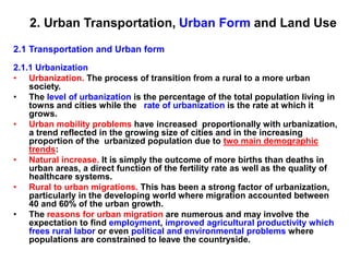
  • 1. 2. Urban Transportation, Urban Form and Land Use 2.1 Transportation and Urban form 2.1.1 Urbanization • Urbanization. The process of transition from a rural to a more urban society. • The level of urbanization is the percentage of the total population living in towns and cities while the rate of urbanization is the rate at which it grows. • Urban mobility problems have increased proportionally with urbanization, a trend reflected in the growing size of cities and in the increasing proportion of the urbanized population due to two main demographic trends: • Natural increase. It is simply the outcome of more births than deaths in urban areas, a direct function of the fertility rate as well as the quality of healthcare systems. • Rural to urban migrations. This has been a strong factor of urbanization, particularly in the developing world where migration accounted between 40 and 60% of the urban growth. • The reasons for urban migration are numerous and may involve the expectation to find employment, improved agricultural productivity which frees rural labor or even political and environmental problems where populations are constrained to leave the countryside.
  • 2. 2.1.2 The Urban Form • At the urban level, demographic and mobility growth have been shaped by the capacity and requirements of urban transport infrastructures: roads, transit systems or simply walkways. Consequently, there is a wide variety of urban forms, spatial structures and associated urban transportation systems. • Urban form. Refers to the spatial imprint of an urban transport system as well as the adjacent physical infrastructures. Jointly, they confer a level of spatial arrangement to cities. • Urban (spatial) structure. Refers to the set of relationships arising out of the urban form and its underlying interactions of people, freight and information.
  • 3. Infrastructures Modes Users Transportation, Urban Form and Spatial Structure Transportation Urban Form Spatial imprint Urban Spatial Structure Spatial interaction Elements of the urban transport system - modes, infrastructures and users - have a spatial imprint which shapes the urban form. Considering that each city has different socioeconomic and geographical characteristics, the spatial imprint of transportation varies accordingly. For instance, while North American cities tend to have an urban form that has been shaped by the automobile, cities in other parts of the world, because of different modal preferences and infrastructure developments, have different urban forms. The urban transport system is also composed of spatial interactions reflecting its spatial structure.
  • 4. 2.1.2 The Urban Form • Even if the geographical setting of each city varies considerably, the urban form and its spatial structure are articulated by two structural elements: • Nodes. These are reflected in the centrality of urban activities, which can be related to the spatial accumulation of economic activities or to the accessibility to the transport system. Terminals, such as ports, railyards, and airports, are important nodes around which activities agglomerate at the local or regional level. Nodes have a hierarchy related to their importance and contribution to urban functions, such as production, management, retailing and distribution. • Linkages. These are the infrastructures supporting flows from, to and between nodes. The lowest level of linkages includes streets, which are the defining elements of the urban spatial structure. There is a hierarchy of linkages moving up to regional roads and railways and international connections by air and maritime transport systems.
  • 5. 2.1.2 The Urban Form Nodes, Linkages and Urban Form • Two basic forms of interdependent nodes are at the core of the urban spatial structure: • Accessibility nodes. Refer to locations that transfer passengers and freight, thus offering accessibility to resources and markets within and/or outside the urban area. They include terminals such as ports, rail stations, airports and distribution centers. • Economic nodes. Refer to locations that perform a function of economic significance. These functions are extremely varied and can include administration, education, retailing and leisure. Economic nodes tend to agglomerate, or to cluster, and are often dependent on access to an accessibility node or a linkage. Such clusters often take the form of central business districts or industrial districts. • The presence of nodes requires linkages, which can be serviced by different transport modes. Road and transit linkages are obviously local in scope often taking the form of a grid that characterizes the form of many cities, while rail, maritime and air linkages integrate the city to a wider context of distribution and trade. The complex set of relationships between nodes and their linkages imply an urban form which is unique in each case.
  • 6. The relationships between Nodes, Linkages and Urban Form Accessibility node Economic node Built area Road / transit linkage Rail linkage Maritime linkage Air linkage CBD Port District Manufacturing District
  • 7. 2.1.2 The Urban Form • Urban transportation is organized in three broad categories of collective, individual and freight transportation. • Collective Transportation (public transit). The purpose of collective transportation is to provide publicly accessible mobility over specific parts of a city. Its efficiency is based upon transporting large numbers of people and achieving economies of scale. It includes modes such as tramways, buses, trains, subways and ferryboats. • Individual Transportation. Includes any mode where mobility is the outcome of a personal choice and means such as the automobile, walking, cycling and the motorcycle. The majority of people walk to satisfy their basic mobility, but this number varies according to the city considered. For instance, walking account for 88% of all movements inside Tokyo while this figure is only 3% for Los Angeles. • Freight Transportation. As cities are dominant centers of production and consumption, urban activities are accompanied by large movements of freight. These movements are mostly characterized by delivery trucks moving between industries, distribution centers, warehouses and retail activities as well as from major terminals such as ports, railyards, distribution centers and airports.
  • 8. 2.1.2 The Urban Form • Historically, movements within cities tended to be restricted to walking, which made medium and long distance urban linkages. This mode is rather inefficient and time-consuming. • Thus, activity nodes tended to be agglomerated and urban forms compact. Many modern cities have inherited an urban form created under such circumstances. • The dense urban cores of many European, Japanese and Chinese cities, for example, enable residents to make between one third and two thirds of all trips by walking and cycling. • At the other end of the spectrum, the dispersed urban forms of most Australian, Canadian and American cities, which were built recently, encourages automobile dependency and are linked with high levels of mobility.
  • 9. 2.1.2 The Urban Form Relationship between space, travel time and different Urban Transportation Modes • For a commuter, the relationship between space and travel time changes dramatically with the transportation mode used: • Walking. Assuming a willingness to commute for one hour, a pedestrian walking at 5 km per hour could cross about 5 km. The space / time relationship of such a commute would be a circle of 10 km of diameter. • Streetcar. A streetcar, like those operating in the first half of the 20th century, could travel around 15 km per hour along fixed lines. In this case, the space / time relationship would be star shaped to reflect walking to the streetcar line and of 15 km of diameter along the lines. • Cycling. The bicycle became a mode of mass transportation in the late 19th and early 20th centuries. With approximately the same speed of a streetcar, but with no fixed line limitations, the space / time relationship of commuting by bicycle would be a circle of 15 km of diameter. • Driving (no freeways). With a driving speed of about 30 km per hour (taking into account of stops, lights, congestion and parking), an automobile creates a spherical space / time relationship of about 30 km in diameter. • Driving (with freeways). Along a freeway, a fixed infrastructure, the driving speed is doubled to 60 km per hour. The space / time relationship is then star shaped with 60 km of diameter along its axis. • Obviously, the real world is much more complex than the theoretical example portrayed here. However, these mode / space relationships apply to anyone commuting.
  • 10. One Hour Commuting According to Different Urban Transportation Modes Streetcar line Freeway Walking Streetcar Cycling Automobile Automobile with freeways 10 km
  • 11. Evolution of AA and surrounding towns
  • 12. 2.1.3. Evolution Of Transportation And Urban Form • The evolution of transportation has generally led to changes in urban form. The more radical the changes in transport technology, the more the urban form has been altered. • Among the most fundamental changes in urban form is the emergence of new clusters expressing new urban activities and new relationships between elements of the urban system. • In many cities, the central business district (CBD), once the primary destination of commuters and serviced by public transportation, has been changed by new manufacturing, retailing and management practices. • Whereas traditional manufacturing depended on centralized workplaces and transportation, technological and transportation developments rendered modern industry more flexible. • In many cases, manufacturing relocated in a suburban setting, if not altogether to entirely new low costs locations. • Retail and office activities are also suburbanizing, producing changes in the urban form. • Concomitantly, many important transport terminals, namely port facilities and railyards, have emerged in suburban areas following new requirements in modern freight distribution.
  • 13. 2.1.3. Evolution Of Transportation And Urban Form • From the 1950s, the growth of suburbs was mainly taking place adjacent to major road corridors, leaving a lot of vacant or farm land in between. Later, intermediate spaces were gradually filled up, more or less coherently. • Highways and ring roads, which circled and radiated from cities, favored the development of suburbs and the emergence of important sub-centers that compete with the central business district for the attraction of economic activities. • As a result, many new job opportunities have shifted to the suburbs (if not to entirely new locations) and the activity system of cities has been considerably modified. • Different parts of a city have different dynamism depending on its spatial pattern. These changes have occurred according to the variety of geographical and historical contexts.
  • 14. 2.1.3. Evolution Of Transportation And Urban Form Evolution of the Spatial Structure of a City • The urban spatial structure basically considers the location of different activities as well as their relationships. • Core activities are those of the highest order in the urban spatial structure, namely tertiary and quaternary activities involved in management (finance and insurance) and consumption (retailing). • Central activities are concerned by production and distribution with activities such as warehousing, manufacturing, wholesaling and transportation. • Peripheral activities are dominantly residential or servicing local needs. • A central area refers to an agglomeration of core and/or central activities within a specific location. The emergence of a CBD (Central Business District; the central area of a city) is the result of an historical process, often occurring over several centuries (depending on the age of a city), that has changed the urban form and the location of economic activities.
  • 15. A B C Core activities Central activities Peripheral activities Evolution of the Spatial Structure of a City Central area Major transport axis (A) Pre industrial era. (B) Industrial revolution. (C) Contemporary era.
  • 16. 2.1.3. Evolution Of Transportation And Urban Form • Obviously, each city has its own history, but it is possible to establish a general common process: • (A) Pre industrial era. For cities that existed before the industrial revolution, the CBD was limited to small section of the city generally nearby the waterfront, the market and/or a site of religious or political importance. These were locations where major transactions took place and thus required financial, insurance, warehousing and wholesale services. • (B) Industrial revolution. With the industrial revolution came mass production and mass consumption. This permitted the emergence of a distinct retailing and wholesaling part of the CBD while manufacturing located outside the core. Managing these expanding activities also created an increasing need for office space that located nearby traditional places of financial interaction. As the industrial revolution matured, major transportation axis spurred from the central area towards the periphery. • (C) Contemporary era. In the contemporary era, industries massively relocated away from the CBD to suburban areas, leaving room to the expansion of administrative and financial activities. The CBD was thus the object of an important accumulation of financial and administrative activities, particularly in the largest cities as several corporations became multinational enterprises. These activities were even more willing to pay higher rents than retailing, thereby pushing some retail activities out of the CBD. New retailing sub-centers emerged in suburban areas because of road accessibility and because of the needs to service these new areas. Warehousing and transportation, no longer core area activities, have also relocated to new peripheral locations.
  • 17. 2.1.3. Evolution Of Transportation And Urban Form Two processes have a substantial impact on contemporary urban forms: • Dispersed urban land development patterns have been dominant in North America over the last 50 years, where land is abundant, transportation costs are low, and the economy has become dominated by service and technology industries. Under such circumstances, it is not surprising to find that there is a strong relationship between urban density and automobile use. For many cities their built up areas have grown at a faster rate than their populations. In addition, commuting has become relatively inexpensive compared with land costs, so households have an incentive to buy lower-priced housing at the urban periphery. Similar patterns can be found in many European cities, but this change is occurring at a lower pace and involving a smaller range. • The decentralization of activities resulted in two opposite effects. First, commuting time has remained relatively stable in duration. Second, commuting increasingly tends to be longer and made using the automobile rather than by public transit. Most transit and road systems were developed to facilitate suburb-to-city, rather than suburb-to-suburb, commuting. As a result, suburban highways are often as congested as urban highways.
  • 18. 2.1.3. Evolution Of Transportation And Urban Form • Although transportation systems and travel patterns have changed considerably over time, one enduring feature remains that most people travel between 30- 40 minutes in one direction. • Globally, people are spending about 1.2 hours per day commuting, wherever this takes place in a low or a high mobility setting. • Different transport technologies, however, are associated with different travel speeds and capacity. As a result, cities that rely primarily on non-motorized transport tend to be different than auto-dependent cities. • Transport technology thus plays a very important role in defining urban form and the spatial pattern of various activities.
  • 19. Possible Urban Movement Patterns Monocentric Polycentric Organized Disorganized Primary flow Secondary flow Cities with a higher level of reliance on public transit tend to be monocentric and have a higher level of organized flows while cities depending more on the automobile tend to be polycentric and have a more disorganized structure of flows. Possible Urban Movement Patterns Cities can structurally classified as polycentric (more common) or monocentric and major flows as organized or disorganized (more common).
  • 20. 2.1.4 The Spatial Imprint Of Urban Transportation • The amount of urban land allocated to transportation is often correlated with the level of mobility. • In the pre-automobile era, about 10% of the urban land was devoted to transportation which were simply roads for a traffic that was dominantly pedestrian. • As the mobility of people and freight increased, a growing share of urban areas is allocated to transport and the infrastructures supporting it. • Large variations in the spatial imprint of urban transportation are observed between different cities as well as between different parts of a city, such as between central and peripheral areas.
  • 21. Urban Form, Hempstead, Long Island, New York Road (11.9%) Parking (21.8%) Building (5.3%) Other (61.0%) •This spatial structure is quite representative of a car dependent neighborhood in the United States. Roads and off- street parking lots jointly account for 33.7% of the total area, while built up areas account for only 5.4%. This figure is actually higher as the numerous residential driveways are not accounted for.
  • 22. 2.1.4 The Spatial Imprint Of Urban Transportation • The major components of the spatial imprint of urban transportation are: • Pedestrian areas. Refer to the amount of space devoted to walking. This space is often shared with roads as sidewalks may use between 10% and 20% of a road's right of way. In central areas, pedestrian areas tend to use a greater share of the right of way and in some instances, whole areas are reserved for pedestrians. However, in a motorized context, most of pedestrian areas are for servicing people's access to transport modes such as parked automobiles. • Roads and parking areas. Refer to the amount of space devoted to road transportation, which has two states of activity; moving or parked. In a motorized city, on average 30% of the surface is devoted to roads while another 20% is required for off-street parking. This implies for each car about 2 off-street and 2 on-street parking spaces. In North American cities, roads and parking lots account between 30 to 60% of the total surface. In Western Europe, roads account for between 15% and 20% of the urban surface while for developing countries, this figure is about 10% (6% on average
  • 23. 2.1.4 The Spatial Imprint Of Urban Transportation • The spatial importance of each transport mode varies according to a number of factors, density being the most important. • If density is considered as a gradient, rings of mobility represent variations in the spatial importance of each mode at providing urban mobility. • Further, each transport mode has unique performance and space consumption characteristics. • The most relevant example is the automobile. It requires space to move around (roads) but it also spends 98% of its existence stationary in a parking space. Consequently, a significant amount of urban space must be allocated to accommodate the automobile, especially when it does not move and is thus economically and socially useless. • At an aggregate level, measures reveal a significant spatial imprint of road transportation among developed countries. In the United States, more land is thus used by the automobile than for housing.
  • 24. 2.1.4 The Spatial Imprint Of Urban Transportation • Cycling areas. In a disorganized form, cycling simply shares access to pedestrian and road space. However, many attempts have been made to create spaces specifically for bicycles in urban areas, with reserved lanes and parking facilities. • Transit systems. Many transit systems, such as buses and tramways, share road space with automobiles, which often impairs their respective efficiency. Attempts to mitigate congestion have resulted in the creation of road lanes reserved to buses either on a permanent or temporary (during rush hour) basis. Other transport systems such as subways and rail have their own infrastructures and, consequently, their own rights of way. • Transport terminals. Refer to the amount of space devoted to terminal facilities such as ports, airports, transit stations, railyards and distribution centers. Globalization has increased the mobility of people and freight, both in relative and absolute terms, and consequently the amount of urban space required to support those activities. Many major terminals are located in the peripheral areas of cities, which are the only locations where sufficient amounts of land are available.
  • 25. 2.1.4 The Spatial Imprint Of Urban Transportation Rings of Mobility • The preponderance of each mode in the spatial imprint of urban transportation as a support to urban mobility is dominantly related to density. The above figure shows three rings of increased density, each characterized by specific mobility considerations: • A (Core area). Often related to a CBD representing the optimum level of urban density and centrality. In such a context, the pedestrian space is dominant as most origins and destinations are close by. Sidewalks tend to be substantial and where the conditions are favorable, a system of overpasses and pedestrian-only streets have been established. This area is often the point of convergence of the regional passenger transport system, implying the presence of transit systems and their associated terminal spaces. The handhold of the road space is mainly attributed to a pattern of streets supporting local circulation. • B (Central area). Represents areas of medium to high densities, often adjacent to core areas. The walking space has lost some of its importance but still support mobility around major nodes (transit stations) and corridors (commercial streets). Commercial terminals, mainly rail freight yards and old port facilities, are also occupying substantial amounts of space. • C (Peripheral / suburban area). Mobility is dominantly provided by road transportation with walking and cycling servicing residual functions, often leisure- oriented. Space consuming terminal activities, such as airport and modern - containerized- port facilities occupy significant amounts of land.
  • 26. Rings of Mobility Pedestrian Road and parking Cycling Transit Terminal Density A B C
  • 27. 2.1.5 Transportation And Urban Structure • Rapid and expanded urbanization occurring around the world involves an increased numbers of trips in urban areas. Cities have traditionally responded to growth in mobility by expanding the transportation supply, by building new highways and/or transit lines. In the developed world, that has mainly meant building more roads to accommodate an ever-growing number of vehicles, therefore creating new urban structures. Several urban spatial structures have accordingly emerged, with the reliance on the automobile being the most important discriminatory factor. Four major types can be identified at the metropolitan scale: • Type I - Completely Motorized Network: Representing an automobile- dependent city with a limited centrality. • Type II - Weak Center: Representing the spatial structure of many American cities where many activities are located in the periphery. • Type III - Strong Center: Representing high density urban centers with well developed public transit systems, particularly in Europe and Asia. • Type IV - Traffic Limitation. Representing urban areas that have implemented traffic control and modal preference in their spatial structure. Commonly, the central area is dominated by public transit.
  • 28. Type I - Completely Motorized Network • Characterized by low to average land use densities, this automobile-oriented city assumes free movements between all locations. • Public transit has a residual function while a significant share of the city is occupied by structures servicing the automobile, notably highways and large parking lots. • Most activities are designed to be accessed with an automobile. This type of urban structure requires a massive network of high capacity highways to the point that urban efficiency is based on individual transportation. • Secondary road converges at highways, along which small centers are located, notably nearby interchanges. • This system characterizes recent cities in a North American context where urban growth occurred in the second half of the twentieth century, such as Los Angeles, Phoenix, Denver and
  • 29. Main Road Highway Activity center Type I - Completely Motorized Network
  • 30. Type II - Weak Center • These cities are characterized by average land use densities and a concentric pattern. • The central business district is relatively accessible by the automobile and is the point of convergence of the transit system, which tend to be under-used and requiring subsidies. • The urban area cannot be cost effectively serviced with the transit system, so services are often oriented along major corridors. • In many cases, ring roads favored the emergence of a set of small centers at the periphery, notably at the convergence of radial lines, some of them effectively competing with the central business district for the location of economic activities. • This system is often related to older cities, which emerged in the first half of the twentieth century, such as Melbourne, San Francisco, Boston, Chicago and Montreal, and were afterwards substantially impacted by motorization.
  • 31. Main Road Highway Activity center Transit line Type II - Weak Center
  • 32. Type III - Strong Center • Characterizes cities having a high land use density and high levels of accessibility to urban transit. There are thus limited needs for highways and parking space in the central area, where a set of high capacity public transit lines are servicing most of the mobility needs. • The productivity of this urban area is thus mainly related to the efficiency of the public transport system. • The convergence of radial roads and ring roads favors the location of secondary centers, where activities that could no longer able to afford a central location converge. • This system characterizes cities having important commercial and financial functions and having grown in the 19th century, such as Paris, New York, Shanghai, Toronto, Sydney and Hamburg.
  • 33. Main Road Highway Activity center Transit line Type III - Strong Center
  • 34. Type IV - Traffic Limitation • Represents urban areas that have efficiently implemented traffic control and modal preference in their spatial structure. • Commonly, the central area is dominated by public transit. • They have a high land use density and were planned to limit the usage of the automobile in central areas for a variety of reasons, such as to preserve its historical character or to avoid congestion. • Public transit is used in central areas, while individual transportation takes a greater importance in the periphery. • Between suburbs and the central city are places of interface between individual (automobile) and collective transportation or between low capacity collective transportation (bus) and high capacity collective transportation (metro, rail). • Several cities are implementing this strategy, namely through congestion pricing, as it keeps cars from the central areas while supporting the bulk of the mobility in the suburbs. • This system typifies cities having a long planning history favoring public transit, particularly in socialist economies. London, Singapore, Hong Kong, Vienna and Stockholm are good examples of this urban transport structure.
  • 35. Type IV - Traffic Limitation Main Road Highway Activity center Transit line
  • 36. 2.1.5 Transportation And Urban Structure Scale and Urban Spatial Structure • There are different scales where transportation systems influence the structure of communities, districts and the whole metropolitan area. For instance, one of the most significant impacts of transportation on the urban structure has been the clustering of activities near areas of high accessibility. • At the community level, the urban spatial structure is influenced by the street patterns and the location of residences and basic services. • At the district level, which can be seen as a conglomeration of various communities, the urban spatial structure is influenced by main roads and specific employment zones. • At the city level, highway, transit systems and major transport terminals are the dominant elements impacting the spatial structure.
  • 37. Scale and Urban Spatial Structure City District Community • Highway and transit systems • Major transport terminals (ports and airports) • Streets • Basic services • Residences • Main roads • Employment zones Scale Components of the spatial structure
  • 38. 2.1.5 Transportation And Urban Structure Ring Roads • Facing the expansion of urban areas, congestion problems and the increasing importance of inter-urban movements, several ring roads have been built around major cities. The Rationale of a Ring Road • The impact of ring roads on the spatial structure is favoring a radial pattern and the development of commercial, residential and industrial activities nearby highway interchanges. • The decreasing dynamism of central areas is often linked with the emergence of centers at the periphery. • Ring roads also improves accessibility within a metropolitan area, especially at the periphery. • As indicated in the next figure, prior to the construction of a ring road, going from point A to point B would take 30 minutes, with delays mainly imposed by having to go through the central area. • Once a ring right has been established, travel time between point A and point B is reduced to 20 minutes.
  • 39. Secondary Center City Center Avoiding the congested central area Structuring Suburban development The Rationale of a Ring Road Spatial Structure Accessibility 5 10 10 5 5 10 10 5 A B A to B = 30 A B 5 10 10 5 5 10 10 5 10 10 10 10 A to B = 20 Before After
  • 40. 2.2. Transportation and Urban Land Use 2.2.1 The Land Use - Transport System • Urban land use comprises two elements; the nature of land use which relates to which activities are taking place where, and the level of spatial accumulation, which indicates their intensity and concentration. • Central areas have a high level of spatial accumulation and corresponding land uses while peripheral areas have lower levels of accumulation. • Most economic, social or cultural activities imply a multitude of functions, such as production, consumption and distribution. These functions take place at specific locations and are part of an activity system. • Activities have spatial locations creating a land use pattern, which is influenced by the existing urban form and spatial structure.
  • 41. 2.2.1 The Land Use - Transport System • Land use form is strongly related to the types of activities that can roughly be divided in to three major classes: • Routine Activities. This class of activities is occurring regularly and is thus predictable. They involve journey to work (residential to industrial / commercial / administrative) and shopping (residential to retailing). The land use pattern generated is thus stable and coherent. Generally, these activities are zonal and links are from areas to areas. • Institutional Activities. Most institutions are located at specific points and generally have links with individuals. This activity system is linked to an urban environment where links are occurring irregularly and according to the lifestyle (students, sports, leisure, etc.) or special needs (health). • Production Activities. This involves a complex network of relationships between firms, such as distribution, warehousing etc. This activity system can be linked to a specific urban environment, but also to a region, nation, or even the world. Some activities are strongly linked to the local urban area, while others are far more linked to the global economy. The land use pattern of an activity may thus be linked to an external (international) process. • These activity systems underline the importance of linkages between land uses, which require movements of people, freight and information. The results of these linkages are land use patterns. • Thus, understanding the set of relationships an industrial district has with its labor, suppliers and customers will provide an overview of the land use patterns in an urban area, but also with other urban areas.
  • 42. The Land Use - Transport System • Urban transportation aims at supporting transport demands generated by the diversity of urban activities in a diversity of urban contexts. • A key for understanding urban entities thus lies in the analysis of patterns and processes of the transport / land use system. This system involves several relationships between the transport system, spatial interactions and land use: • Transport system. Considers the set of transport infrastructures and modes that are supporting urban movements of passengers and freight. It generally expresses the level of accessibility. • Spatial interactions. Consider the nature, extent, origins and destinations of the urban movements of passengers and freight. They take into consideration the attributes of the transport system as well as the land use factors that are generating and attracting movements. • Land use. Considers the level of spatial accumulation of activities and their associated levels of mobility requirements. Land use is commonly linked with demographic and economic attributes.
  • 43. Infrastructures Modes Users Transportation, Activity Systems and Land Use Transportation Urban Form Spatial imprint Urban Spatial Structure Spatial interaction Labor Customers Suppliers Activity Land Use Pattern Spatial location
  • 44. The Land Use - Transport System • The behavioral patterns of individuals, institutions and firms have an imprint on land use. • The representation of this imprint requires a typology of land use, which can be formal or functional: • Formal land use representations are concerned with qualitative attributes of space such as its form, pattern and aspect and are descriptive in nature. • Functional land use representations are concerned with the economic nature of activities such as production, consumption, residence, and transport, and are mainly a socioeconomic description of space. • The formal land use map can be created with aerial or remote sensing images, but it is very difficult to infer any functional attributes from these observations, especially for urban land use. • The functional land use map requires an implicit knowledge of the functional attributes of an area, commonly gained through field observations.
  • 45. Formal and Functional Land Use Road Parking Building Other Formal Land Use Functional Land Use Road Parking Residential Other Commercial Institutional Industrial The above maps represent the land uses of the same neighborhood, classified formally (left) and functionally (right). Under such circumstances, land use that has been formally classified as building (built up) can be functionally described as residential, commercial, institutional or industrial.
  • 46. Transport Infrastructure and Activity Location Freight based Population based Mixed Mixed Each type of urban activity has its own mobility requirements that are serviced by the urban transport system. This figure illustrates locational preferences according to urban transport infrastructures. Population based activities (e.g. residential) are dominant where rail (metro and passenger) and bus infrastructures are converging, while freight based activities (e.g. manufacturing and warehousing) agglomerate nearby high capacity road infrastructures.
  • 47. 2.2.2. Transportation And Urban Dynamics • Both land use and transportation are part of a dynamic system that is subject to external influences. Each component of the system is constantly evolving due to changes in technology, policy, economics, demographics and even culture/values, among others. As a result, the interactions between land use and transportation are played out as the outcome of the many decisions made by residents, businesses and governments. • The most significant components of urban dynamics are: • Land use. This is the most stable component of urban dynamics, as changes are likely to modify the land use structure over a rather long period of time. The main impact of land use on urban dynamics is its function of a generator and attractor of movements. • Transport network. This is also considered to be a rather stable component of urban dynamics, as transport infrastructures are built for the long term. The main contribution of the transport network to urban dynamics is the provision of accessibility. Changes in the transport network will impact accessibility and movements. • Movements. The most dynamic component of the system since movements of passengers or freight reflect changes almost immediately. • Employment and workplaces. They account for significant inducement effects over urban dynamics since many models often consider employment as an exogenous factor. This is specifically the case for employment that is categorized as basic, or export oriented, which is linked with specific economic sectors such as manufacturing. Commuting is a direct outcome of the number of jobs and the location of workplaces. • Population and housing. They act as the generators of movements, because residential areas are the sources of commuting.
  • 48. Dynamics of Urban Change Land Use Network Commuting Freight Transport Employment Workplaces Housing Population Very Slow Very Fast Fast Slow Very Slow Pace of Change