SlideShare a Scribd company logo
1 of 15
Geology of the Washington,
D.C. area
IMPACT! – A Geological Formation
Overview
• I.M.P.A.C.T. =
“Imagine the
Movement of Plates
that created both the
Appalachian
Mountains and the
Atlantic Ocean basin
along with the Crater
from the Chesapeake
Bay meteorite that
helped shape the
Washington, D.C. area
over Time”
You know the I.M.P., so let’s get to the
A.C.T.
• Grenville orogeny (Precambrian)
• Taconic orogeny (Late Ordovician)
• Acadian orogeny (Late Devonian)
• Alleghenian orogeny
(Mississippian/Pennsylvanian)
• Creation of Atlantic Ocean upon
breakup of Pangea (180 Ma)
“A” = Formation of the Appalachians
and Atlantic Ocean
Chesapeake Bay Meteorite and Bay
Formation
“C” = Crater from the
Chesapeake Bay Meteorite
• Exmore Crater result of impact from
meteorite 35 million years ago
• Equivalent to the size of Rhode Island
and the depth of the Grand Canyon
• Caused disruption of natural river flows,
creating deep canyons in soft Coastal
Plain sediment
• Freshwater from the melting of glaciers
and associated flooding from the end of
the last Ice Age mixed with saline Atlantic
Ocean water, creating Chesapeake Bay
• Largest estuary in U.S. and assumed
present shape ~3,000 years ago “T” = Geologic Time
“Geology is the study of pressure and time.
That’s all it takes really, pressure, and time.”
– Vance Brown
Washington, D.C.’s Geologic Setting
• Atlantic Coastal Plain
• Flat, low-lying area composed of
crystalline rock covered by wedge-shaped
layers of sand, gravel, and clay
• Piedmont Plateau
• Diverse topography composed of
metamorphosed sedimentary and
volcanic rocks like schist, granite, and
sandstones
• Triassic Lowland
• Composed of shales and
sandstones with alluvial fans of
limestone and quartz on
western edge
• Blue Ridge
• Region of valleys and ridges
underlain by folded
metamorphic and igneous rocks
like granite and greenstone
The Terraces of Washington, D.C.
The Fall Line
“...we were intercepted with great craggy stones that
[stand] in midst of the river, where the water falleth so
rudely and with such a violence as not any boat could
possibly pass...” – John Smith (1607)
• Line of rapids and falls marking where the waters
rushing over the Piedmont encounter the easily
erodible sediments of the Coastal Plain
Teddy Roosevelt Island
Great Falls Park
• Located along the Fall Line, 14 miles upstream from Teddy Roosevelt Island
• Potomac River experiences its most dramatic elevation change here, cutting
through the Piedmont and reaching the Coastal Plain
• When hiking, this change can be seen first hand and it is stunning
Goes from this … … to this in less than a mile.
Rock Creek Park
• Also located along the Fall Line, it covers over 2,800 acres (7% of D.C.)
• Northern and western portions home to exposed metamorphic rock like
boulder gneiss, mica schist, and quartzite
• Southern and eastern portions home to sand, gravel, and silt closely
associated with the Coastal Plain
• Home to two rock formations, the Laurel Formation and the Sykesville
Formation, which are separated by the 1.8-mile wide system of geologic
faults known as the Rock Creek Shear Zone (evidence of which in the
Laurel Formation is shown in the figure on the right)
Smithsonian National Zoological Park
“A geologists paradise” – R.S. Bassler, 1933
“The Zoo’s foundation is a living physical geology text book” – UDC geologists
• U-shaped bend of Rock Creek near Zoo due
to faulting (shown above)
• Evidence of faulting outside Zoo (shown on
right)
Darton’s Fault
• Named after N. H. Darton,
who had cage put around fault
in the 1920s for its protection
• Evidence of previous thrusting
event
• The old metamorphic rocks of
the Piedmont were pushed over
the younger Coastal Plain
sediments
The Building Stones of D.C. and a Brief
History of the National Mall
Old stones from the CapitolKensington tonaliteRed sandstone
Fun with Maps!
1976 version 2016 version
Thank You!

More Related Content

What's hot

Erosion, deposition
Erosion, depositionErosion, deposition
Erosion, deposition
emaleismith
 
Coastal erosion processes
Coastal erosion processesCoastal erosion processes
Coastal erosion processes
MsGeo
 
Landforms
LandformsLandforms
Landforms
Mr. M
 
Coastal Landforms
Coastal  LandformsCoastal  Landforms
Coastal Landforms
whiskeyhj
 
Coastal erosional processes and landforms lesson 4
Coastal erosional processes and landforms   lesson 4Coastal erosional processes and landforms   lesson 4
Coastal erosional processes and landforms lesson 4
Ms Geoflake
 
Coastal Processes Good
Coastal Processes GoodCoastal Processes Good
Coastal Processes Good
SHS Geog
 
L5 Distictive Coastal Deposition Features
L5 Distictive Coastal Deposition FeaturesL5 Distictive Coastal Deposition Features
L5 Distictive Coastal Deposition Features
tudorgeog
 
Coastal features of erosion
Coastal features of erosionCoastal features of erosion
Coastal features of erosion
Lala Gordon
 
Chapter20 coastal processes
Chapter20 coastal processesChapter20 coastal processes
Chapter20 coastal processes
ashtonx
 
Slide
SlideSlide
Slide
MsGeo
 

What's hot (20)

Erosion, deposition
Erosion, depositionErosion, deposition
Erosion, deposition
 
land forms formed by seawaves
land forms formed by seawavesland forms formed by seawaves
land forms formed by seawaves
 
Coastal erosion processes
Coastal erosion processesCoastal erosion processes
Coastal erosion processes
 
Coastal Landforms
Coastal LandformsCoastal Landforms
Coastal Landforms
 
Coastal
CoastalCoastal
Coastal
 
Landforms
LandformsLandforms
Landforms
 
GEOGRAPHY IGCSE: COASTAL LANDFORMS
GEOGRAPHY IGCSE: COASTAL LANDFORMSGEOGRAPHY IGCSE: COASTAL LANDFORMS
GEOGRAPHY IGCSE: COASTAL LANDFORMS
 
Coastal Landforms
Coastal  LandformsCoastal  Landforms
Coastal Landforms
 
Coastal erosional processes and landforms lesson 4
Coastal erosional processes and landforms   lesson 4Coastal erosional processes and landforms   lesson 4
Coastal erosional processes and landforms lesson 4
 
Coastal erosion cliffs etc
Coastal erosion cliffs etcCoastal erosion cliffs etc
Coastal erosion cliffs etc
 
Field lab part 2
Field lab part 2Field lab part 2
Field lab part 2
 
Landforms unit 11
Landforms unit 11Landforms unit 11
Landforms unit 11
 
Coastal Processes Good
Coastal Processes GoodCoastal Processes Good
Coastal Processes Good
 
Lithosphere 2 notes: Tectonics
Lithosphere 2 notes: TectonicsLithosphere 2 notes: Tectonics
Lithosphere 2 notes: Tectonics
 
GEOGRAPHY IGCSE: COASTAL PROCESSES
GEOGRAPHY IGCSE: COASTAL PROCESSESGEOGRAPHY IGCSE: COASTAL PROCESSES
GEOGRAPHY IGCSE: COASTAL PROCESSES
 
L5 Distictive Coastal Deposition Features
L5 Distictive Coastal Deposition FeaturesL5 Distictive Coastal Deposition Features
L5 Distictive Coastal Deposition Features
 
Coastal features of erosion
Coastal features of erosionCoastal features of erosion
Coastal features of erosion
 
Chapter20 coastal processes
Chapter20 coastal processesChapter20 coastal processes
Chapter20 coastal processes
 
Coastal processes
Coastal processes Coastal processes
Coastal processes
 
Slide
SlideSlide
Slide
 

Viewers also liked

cara membuat klepon khas desa Tegalsambi (kintelan) Jepara, Indonesia
cara membuat klepon khas desa Tegalsambi (kintelan) Jepara, Indonesiacara membuat klepon khas desa Tegalsambi (kintelan) Jepara, Indonesia
cara membuat klepon khas desa Tegalsambi (kintelan) Jepara, Indonesia
roffi siana
 
Strategic-Planning-Project-22-01-2012
Strategic-Planning-Project-22-01-2012Strategic-Planning-Project-22-01-2012
Strategic-Planning-Project-22-01-2012
Mohamed Taher
 

Viewers also liked (15)

cara membuat klepon khas desa Tegalsambi (kintelan) Jepara, Indonesia
cara membuat klepon khas desa Tegalsambi (kintelan) Jepara, Indonesiacara membuat klepon khas desa Tegalsambi (kintelan) Jepara, Indonesia
cara membuat klepon khas desa Tegalsambi (kintelan) Jepara, Indonesia
 
Proyecto1 b romerobalderas_jorgeantonio
Proyecto1 b romerobalderas_jorgeantonioProyecto1 b romerobalderas_jorgeantonio
Proyecto1 b romerobalderas_jorgeantonio
 
Tema 1
Tema 1Tema 1
Tema 1
 
Servicio comunitario
Servicio comunitarioServicio comunitario
Servicio comunitario
 
Dennis L Crews
Dennis L CrewsDennis L Crews
Dennis L Crews
 
Tema 1 la sociedad del conocimiento
Tema 1 la sociedad del conocimientoTema 1 la sociedad del conocimiento
Tema 1 la sociedad del conocimiento
 
Respect de La Laicite - Les Agents Publics Vont Etre Mieux Formes Et Epaules
Respect de La Laicite - Les Agents Publics Vont Etre Mieux Formes Et EpaulesRespect de La Laicite - Les Agents Publics Vont Etre Mieux Formes Et Epaules
Respect de La Laicite - Les Agents Publics Vont Etre Mieux Formes Et Epaules
 
Personal branding (muhammad salman hakim)
Personal branding (muhammad salman hakim)Personal branding (muhammad salman hakim)
Personal branding (muhammad salman hakim)
 
Ecologia, educacion y conciencia ambientalista
Ecologia, educacion y conciencia ambientalistaEcologia, educacion y conciencia ambientalista
Ecologia, educacion y conciencia ambientalista
 
Conductividad quimica jeysson ramos
Conductividad quimica jeysson ramosConductividad quimica jeysson ramos
Conductividad quimica jeysson ramos
 
P lemus act_4_u4_foro
P lemus act_4_u4_foroP lemus act_4_u4_foro
P lemus act_4_u4_foro
 
.Membangun personal branding
.Membangun personal branding.Membangun personal branding
.Membangun personal branding
 
Writing a teel paragraph for beginners
Writing a teel paragraph for beginnersWriting a teel paragraph for beginners
Writing a teel paragraph for beginners
 
Jessica Swendsen
Jessica SwendsenJessica Swendsen
Jessica Swendsen
 
Strategic-Planning-Project-22-01-2012
Strategic-Planning-Project-22-01-2012Strategic-Planning-Project-22-01-2012
Strategic-Planning-Project-22-01-2012
 

Similar to Mike_Stoever_Slides

Geologic Evolution of the Grand Canyon
Geologic Evolution of the Grand CanyonGeologic Evolution of the Grand Canyon
Geologic Evolution of the Grand Canyon
Mitchell Jennings
 
Rockies 95
Rockies 95Rockies 95
Rockies 95
DoDad
 
Missoula flood
Missoula floodMissoula flood
Missoula flood
Joyce Fan
 
Mosquito Poster Final
Mosquito Poster FinalMosquito Poster Final
Mosquito Poster Final
Samuel Timko
 

Similar to Mike_Stoever_Slides (20)

Mike_Stoever_Text
Mike_Stoever_TextMike_Stoever_Text
Mike_Stoever_Text
 
Plate Tectonics
Plate TectonicsPlate Tectonics
Plate Tectonics
 
Washington land features
Washington land featuresWashington land features
Washington land features
 
Geologic Evolution of the Grand Canyon
Geologic Evolution of the Grand CanyonGeologic Evolution of the Grand Canyon
Geologic Evolution of the Grand Canyon
 
The Earth
The EarthThe Earth
The Earth
 
shoaf_brian_ccfe
shoaf_brian_ccfeshoaf_brian_ccfe
shoaf_brian_ccfe
 
Carter Reese: Geology Field Assignment
Carter Reese: Geology Field AssignmentCarter Reese: Geology Field Assignment
Carter Reese: Geology Field Assignment
 
Geology Lab/Field Assignment
Geology Lab/Field AssignmentGeology Lab/Field Assignment
Geology Lab/Field Assignment
 
GY363termpaper
GY363termpaperGY363termpaper
GY363termpaper
 
Improving Ocean Literacy by Teaching the Geology of the Great Lakes
Improving Ocean Literacy by Teaching the Geology of the Great LakesImproving Ocean Literacy by Teaching the Geology of the Great Lakes
Improving Ocean Literacy by Teaching the Geology of the Great Lakes
 
Field Assingment
Field AssingmentField Assingment
Field Assingment
 
Lithosphere 3 notes: NC Geology
Lithosphere 3 notes: NC GeologyLithosphere 3 notes: NC Geology
Lithosphere 3 notes: NC Geology
 
Rockies 95
Rockies 95Rockies 95
Rockies 95
 
Missoula flood
Missoula floodMissoula flood
Missoula flood
 
Powerpoint tahoe
Powerpoint tahoePowerpoint tahoe
Powerpoint tahoe
 
Geographical Tour of USA
Geographical Tour of USAGeographical Tour of USA
Geographical Tour of USA
 
Mosquito Poster Final
Mosquito Poster FinalMosquito Poster Final
Mosquito Poster Final
 
Geology of Lake Tahoe Basin - 2015
Geology of Lake Tahoe Basin - 2015Geology of Lake Tahoe Basin - 2015
Geology of Lake Tahoe Basin - 2015
 
Lithosphere 3 NC Geology Notes
Lithosphere 3 NC Geology NotesLithosphere 3 NC Geology Notes
Lithosphere 3 NC Geology Notes
 
Acadia
AcadiaAcadia
Acadia
 

More from Michael J. (Mike) Stoever (7)

Mike Stoever_Ecology IRP
Mike Stoever_Ecology IRPMike Stoever_Ecology IRP
Mike Stoever_Ecology IRP
 
Mike Stoever_Golden Eagle Final Memo
Mike Stoever_Golden Eagle Final MemoMike Stoever_Golden Eagle Final Memo
Mike Stoever_Golden Eagle Final Memo
 
Mike Stoever_Non-technical summary
Mike Stoever_Non-technical summaryMike Stoever_Non-technical summary
Mike Stoever_Non-technical summary
 
M. Stoever Final Assignment
M. Stoever Final AssignmentM. Stoever Final Assignment
M. Stoever Final Assignment
 
M. Stoever Watershed Report
M. Stoever Watershed ReportM. Stoever Watershed Report
M. Stoever Watershed Report
 
M. Stoever GIS Final Paper
M. Stoever GIS Final PaperM. Stoever GIS Final Paper
M. Stoever GIS Final Paper
 
M. Stoever Final Map
M. Stoever Final MapM. Stoever Final Map
M. Stoever Final Map
 

Mike_Stoever_Slides

  • 1. Geology of the Washington, D.C. area
  • 2. IMPACT! – A Geological Formation Overview • I.M.P.A.C.T. = “Imagine the Movement of Plates that created both the Appalachian Mountains and the Atlantic Ocean basin along with the Crater from the Chesapeake Bay meteorite that helped shape the Washington, D.C. area over Time”
  • 3. You know the I.M.P., so let’s get to the A.C.T. • Grenville orogeny (Precambrian) • Taconic orogeny (Late Ordovician) • Acadian orogeny (Late Devonian) • Alleghenian orogeny (Mississippian/Pennsylvanian) • Creation of Atlantic Ocean upon breakup of Pangea (180 Ma) “A” = Formation of the Appalachians and Atlantic Ocean
  • 4. Chesapeake Bay Meteorite and Bay Formation “C” = Crater from the Chesapeake Bay Meteorite • Exmore Crater result of impact from meteorite 35 million years ago • Equivalent to the size of Rhode Island and the depth of the Grand Canyon • Caused disruption of natural river flows, creating deep canyons in soft Coastal Plain sediment • Freshwater from the melting of glaciers and associated flooding from the end of the last Ice Age mixed with saline Atlantic Ocean water, creating Chesapeake Bay • Largest estuary in U.S. and assumed present shape ~3,000 years ago “T” = Geologic Time “Geology is the study of pressure and time. That’s all it takes really, pressure, and time.” – Vance Brown
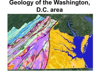
  • 5. Washington, D.C.’s Geologic Setting • Atlantic Coastal Plain • Flat, low-lying area composed of crystalline rock covered by wedge-shaped layers of sand, gravel, and clay • Piedmont Plateau • Diverse topography composed of metamorphosed sedimentary and volcanic rocks like schist, granite, and sandstones • Triassic Lowland • Composed of shales and sandstones with alluvial fans of limestone and quartz on western edge • Blue Ridge • Region of valleys and ridges underlain by folded metamorphic and igneous rocks like granite and greenstone
  • 6. The Terraces of Washington, D.C.
  • 7. The Fall Line “...we were intercepted with great craggy stones that [stand] in midst of the river, where the water falleth so rudely and with such a violence as not any boat could possibly pass...” – John Smith (1607) • Line of rapids and falls marking where the waters rushing over the Piedmont encounter the easily erodible sediments of the Coastal Plain
  • 9. Great Falls Park • Located along the Fall Line, 14 miles upstream from Teddy Roosevelt Island • Potomac River experiences its most dramatic elevation change here, cutting through the Piedmont and reaching the Coastal Plain • When hiking, this change can be seen first hand and it is stunning Goes from this … … to this in less than a mile.
  • 10. Rock Creek Park • Also located along the Fall Line, it covers over 2,800 acres (7% of D.C.) • Northern and western portions home to exposed metamorphic rock like boulder gneiss, mica schist, and quartzite • Southern and eastern portions home to sand, gravel, and silt closely associated with the Coastal Plain • Home to two rock formations, the Laurel Formation and the Sykesville Formation, which are separated by the 1.8-mile wide system of geologic faults known as the Rock Creek Shear Zone (evidence of which in the Laurel Formation is shown in the figure on the right)
  • 11. Smithsonian National Zoological Park “A geologists paradise” – R.S. Bassler, 1933 “The Zoo’s foundation is a living physical geology text book” – UDC geologists • U-shaped bend of Rock Creek near Zoo due to faulting (shown above) • Evidence of faulting outside Zoo (shown on right)
  • 12. Darton’s Fault • Named after N. H. Darton, who had cage put around fault in the 1920s for its protection • Evidence of previous thrusting event • The old metamorphic rocks of the Piedmont were pushed over the younger Coastal Plain sediments
  • 13. The Building Stones of D.C. and a Brief History of the National Mall Old stones from the CapitolKensington tonaliteRed sandstone
  • 14. Fun with Maps! 1976 version 2016 version

Editor's Notes

  1. Figure source: http://www.virginiaplaces.org/regions/fallshape.html
  2. Figure source: http://www.space.com/22909-ancient-asteroid-impacts-earth-effects.html
  3. Figure sources: http://www.rci.rutgers.edu/~schlisch/103web/NJcontext/ENAhistory.html
  4. Figure source: http://impactcraters.us/chesapeake_bay_virginia Quote source: https://books.google.co.in/books?id=4mEPmOGMU1oC&pg=PA172&hl=en#v=onepage&q&f=false
  5. Figure source: http://pubs.usgs.gov/gip/stones/setting.html
  6. Figure source: https://thegrowingseason.wordpress.com/
  7. Figure and quote sources: http://www.virginiaplaces.org/regions/fallshape.html; http://nationalzoo.si.edu/AboutUs/History/beneathitall.cfm
  8. Figure source: http://www.virginiaplaces.org/regions/fallshape.html
  9. Figure source: http://pxhdwsm.com/nike+park+great+falls+va; the author’s personal photo
  10. Figure sources: http://www.savetherockcreekparkdeer.com/rock-creek-park.html; http://blogs.agu.org/mountainbeltway/2013/04/29/kink-bands-in-highly-strained-laurel-formation-rock-creek-shear-zone-dc/
  11. Figure source: The author’s personal photos
  12. Figure source: The author’s personal photos
  13. Figure source: http://washington.org/DC-guide-to/smithsonian-institution-building-castle; http://www.explorenaturalcommunities.org/parks-places/rock-creek-park/natural-history/physical-setting/geology; http://www.washingtoncitypaper.com/articles/37113/stone-cold-whodunit
  14. Figure sources: http://pubs.usgs.gov/of/1976/0849/plate-2.pdf; http://ngmdb.usgs.gov/Prodesc/proddesc_277.htm