Concepts and Methods of Embedding Statistical Data into Maps
Geosuiteonline EN
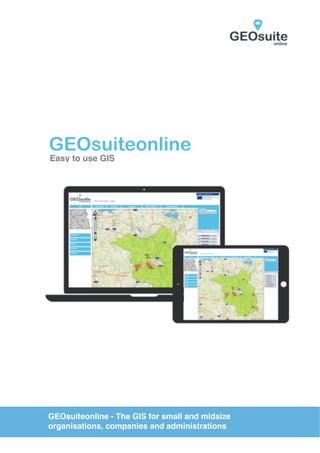
1. GEOsuiteonline
Easy to use GIS
GEOsuiteonline - The GIS for small and midsize
organisations, companies and administrations
2. WWW.GEOSUITEONLINE.DE
The problem:
Our solution:
To exploit the full potential of spatial data it is necessary, that a GIS
application supports teamwork, easy collection, editing and analysis of
Geo data. This must be combined with the ability to use it in the office
or in the field on modern tablet PCs. The seemingly confused market
offer of GIS applications, countless functions and high financial costs
present a nearly insurmountable hurdle for small to midsize
organisations and companies to benefit from the advantages of spatial
data and GIS.
GEOsuiteonline is an easy to use software service which
provides functionalities of a GIS application. Information can be
linked to a location, visualized and analyzed related to relevant
features. It is easy to create thematic maps and share maps with
other users. It provides user with the ability to easily collect data
in the field or in the office. GEOsuiteonline allows users to save
considerable software costs, giving them the ability to exploit the
benefits of geo data.
„We have to develop an easy to use GIS application,
that anyone can use in the office or on a mobile in
the field. It must support teamwork and save users
large investments in hardware and software.“
3. WWW.GEOSUITEONLINE.DE
What does GEOsuiteonline
GIS offer?
All necessary functions to collect, edit
and analyze geo data
A web based software application.
This guarantees access from any
number of work places without a local
installation bypassing considerable
investments in hardware and software
Access rights management ensuring
each user can only see their
authorised data
The open concept enables users to
import standard data formats such as
Shape files and to integrate OGC
conforming web services (WMS and
WFS)
An intuitive, easy to understand user
interface without cryptic symbols or
icons.
Flexible extension possibilities on your
demands.
A simple, transparent pricing model for
the use of our cloud edition
No minimum contract term,
subscription on a monthly basis
Deployment on your own server
possible
4. WWW.GEOSUITEONLINE.DE
For large teams -
GEOsuiteonline Server-Edition:
✓ GEOsuiteonline on your own server
✓ corporate-wide teams
✓ all functions on your intranet
✓ your own firewall protection
✓ integration with existing GIS-infrastructure
✓ integration of existing enterprise databases
✓ individual customisations possible
✓ premium support
✓ additional pay-as-you-go geodata services on request
For small teams -
GEOsuiteonline Cloud-Edition:
✓ own server not necessary
✓ all functions on the internet
✓ e-mail support
✓ competitive subscription fee
✓ no minimum contract term
✓ monthly subscription
✓ additional pay-as-you-go geodata services on request
5. WWW.GEOSUITEONLINE.DE
GEOsuiteonline -
The GIS all-in-one solution
✓ Import and export of GIS-standard formats (Shape, DXF)
✓ Import of georeferenced raster data (TIFF)
✓ Integration and publishing of OGC-conforming geoservices (WMS and
WFS)
✓ Linking of attribute data from Microsoft excel-files (XLS)
✓ Classification of geodata with symbols and colours
✓ Storing of map collections
✓ Creation of new datasets and sharing with other users
✓ Creation, editing and deletion of geo-objects
✓ Editing of attribute data from geo-objects
✓ Exporting maps as PDF-Files
✓ Creating of screenshots for documents insertion
✓ Identification of geo-objects
✓ Query of data sets and geo-objects
✓ spatial Analysis (intersection, buffer)
✓ output of query results to use it in Microsoft Excel
GEOsuiteonline -
Geodata services
You need up-to-date geo data for your assets?
We support you with the acquisition and integration of spatial data.
We provide GPS and tachymetric data collection, digitising of paper maps
and data collection with modern uas (multirotor or fixed wings). We deliver
high resolution digital orthophotos and digital terrain models.
Please call us. We will help you!
6. Vermessungsingenieure
Misselwitz & Kaden
Partnerschaftsgesellschaft
Ruhlsdorfer Straße 77
14513 Teltow
Tel. 03328 336810
Fax 03328 336811
Mail post@misselwitz-kaden.de
WWW.GEOSUITEONLINE.DE
GEOsuiteonline is a project to strengthen the Geodata
Infrastructure in the federal state of Brandenburg and
was funded the help of the European ERDF.