Russian Call Girls In Rajiv Chowk Gurgaon ❤️8448577510 ⊹Best Escorts Service ...
Super map gis 8c
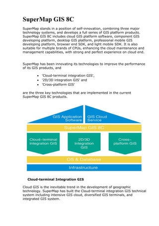
1. SuperMap GIS 8C
SuperMap stands in a position of self-innovation, combining three major
technology systems, and develops a full series of GIS platform products.
SuperMap GIS 8C includes cloud GIS platform software, component GIS
developing platform, desktop GIS platform, professional mobile GIS
developing platform, browser end SDK, and light mobile SDK. It is also
suitable for multiple brands of CPUs, enhancing the cloud maintenance and
management capabilities, with strong and perfect experience on cloud end.
SuperMap has been innovating its technologies to improve the performance
of its GIS products, and
'Cloud-terminal integration GIS',
'2D/3D integration GIS' and
'Cross-platform GIS'
are the three key technologies that are implemented in the current
SuperMap GIS 8C products.
Cloud-terminal Integration GIS
Cloud GIS is the inevitable trend in the development of geographic
technology. SuperMap has built the Cloud-terminal integration GIS technical
system including intensive GIS cloud, diversified GIS terminals, and
integrated GIS system.
2. Intensive GIS cloud provides and manages GIS services, and is done to
realize the intensive use of the computing resources and provide high
availability of GIS service.
Diversified terminals use the unified service interface to connect the GIS
cloud services, and realize GIS application development and GIS resources
access by different terminals, and provide multiple GIS SDKs to integrate
with common applications.
Based on Cloud-terminal integration GIS technology, SuperMap provides a
powerful cloud GIS platform and rich GIS terminal products, helping
customers to more promptly build highly efficient and stable GIS system to
meet different requirements.
2D/3D Integration GIS
SuperMap builds the product family with 2D/3D integration GIS technology,
and provides GIS platform and technical support for the industrial solutions
in oblique photography model, building information modeling (BIM) and 3D
pipelines. It supports rapid building of 3D pipelines to attack the limitation of
massive high density pipe nodes and pipelines data in providing 3D facility
network analysis, a powerful platform support for the application of 3D
pipelines.
SuperMap offers several 3D terminal products, to bring a more broad
application space for users.
Cross-platform GIS
SuperMap products support a variety of CPUs including X86, IBM POWER,
Itanium, ARM (Feiteng 1500A), MIPs (Loongson), to run on various
operating systems like Windows, Linux, AIX, and K-UX. In addition,
SuperMap releases mobile GIS products with complete GIS functions,
support for iOS and Android, with powerful offline functions and 2D/3D
integration ability, which are adapted to the mobile GIS applications that
require data confidentiality, limited network flow or without network.
GIS Platform for Client
SuperMap iDesktop 8C
It is a plug-in style desktop GIS development platform, capable of 2D and
3D integration for functions such as data processing, mapping, analysis,
nautical charts, supporting plug-in extension development and seamless
accessing online map services, which make cloud resources collaborative
sharing more convenient.
Main Functions of SuperMap iDesktop
Multi‐language
3. Data management function
Provides functions of creating, editing, managing, accessing spatial
data and other attribute data.
Supports multiple data engines, like SQL, Oracle, Oracle Spatial,
PostgreSQL, DB2, MySQL, etc. Also supports directly opening ArcSDE
data;
Supports directly opening Web data, like WMS, WFS, WMTS,
GoogleMap, Baidu Map, OpenStreetMaps, etc;
Supports direct access to Shp, mif, dxf, dwg files, etc.
Data conversion and processing function
Provides data conversion among SuperMap data and other GIS, CAD
data formats, supporting more than 50 data formats;
Provides rich data processing functions, like data merging, row
appending, column appending and reclassifying;
Provides topology functions like topology checking, network by
topology, polygon by topology, line topology validating, etc.;
Supports creating 3D cache for nautical image, terrain, model, storing
cache results into Objects drawing and editing function
Provides multiple object drawing functions, including point, line,
polygon, text drawing;
Provides multiple object editing functions like trimming, extending,
breaking, moving, etc.;
Spatial and attribute data query function
Provides SQL query, spatial query, attribute query, etc.;
Spatial analysis function
Supports parallel computing, big memory mode;
Provides vector analysis functions like buffer analysis, overlay
analysis, dynamic segmentation, etc.;
Provides spatial analysis functions like kernel density analysis,
distance measurement, etc.;
Provides surface analysis functions like extracting Isoline/contour
surface, slope and aspect, excavation and filling, etc.;
Provides raster analysis functions like sun radiation analysis, DEM
curvature calculation, interpolation, hydrological analysis, raster
statistics, etc.;
Provides traffic network analysis functions like optimal path analysis,
logistics and distribution, service area analysis, location‐allocation,
closest facility finding, key factor analyzing, etc.;
Provides facility network analysis functions like tracking analysis,
accessibility analysis, etc.
4. Map creating function
Provides comprehensive map display, editing and output functions;
Provides thematic mapping, including label maps, graph maps, dot
density maps, etc.;
Provides rich symbol resources and easy-to-use symbol library
manager;
3D scenes
Supports loading and viewing large detailed model, stretch model,
large image data;
Supports planar and spherical scenes;
Supports underground scene displaying and surface excavating;
Supports particle effect, simulating some abstract effects like frame,
fog, fountain, explosion, firework, rain, snow in the scenes;
Supports 3D water surface effect, providing 3D surface symbol.
2D & 3D integration of data, displaying, querying, analyzing
Supports 2D and 3D integration of data, the same data can be
displayed, processed or analyzed in 2D or 3D mode. There is no need
to switch between different software;
Supports 3D displaying for 2D data;
Supports 3D stretch and quick model building for 2D polygons;
Supports direct projection of 2D map into 3D scene;
Supports querying the location, height of arbitrary points and
querying the attribute information of arbitrary objects.
Real‐time dynamic display of 3D analysis function
Supports 3D analysis functions like visibility analysis, slope and
aspect analysis, viewshed analysis, skyline analysis;
Supports 3D network analysis functions like pipe burst analysis, key
facility analysis, etc.
Fully supports 3D oblique photography modelling data
Supports storing, displaying and publishing nautical map data
Custom, extensible desktop
Supports customizing existing software interface or developing a new
one.
Server GIS Platform for Cloud
SuperMap iServer 8C
This is a robust GIS cloud application server, which has:
5. Cross-platform GIS kernel, supports Windows, Linux, Unix.
Embedded multi-layer intelligent cluster technology, breaking the
limits of only supporting the same operation system, the same
service type of traditional GIS cluster technology;
Embedded parallel tiling technology, supporting 2D & 3D tiling,
which improved the performance of tiling;
Embedded parallel spatial analysis technology, saving the time of
analysis like overlay analysis, interpolation analysis, optimal path
analysis, etc.;
Provides 3D services, 3D data display like multiple scenes, multi-
effect. Also provides 3D network analysis and 3D spatial analysis;
2D&3D integration service publishing,
management and clustering functions to provide developing
capability on multiple levels.
SuperMap iPortal 8C
It is a cloud GIS portal platform, supporting:
Quick integration, sharing and management on multiple GIS resources,
like maps, services, scenes and data;
Monitor multiple GIS servers to ensure the smooth operation of
platform. Supports access control for multi-source services, convenient
to use, manage and maintenance.
Embedded batch GIS service registration and automatic sync
technology, making maintenance more convenient and intelligent;
6. Embedded 3D viewing web app, realizing cross browser online query
and view all the scenic resources in portal;
Its portal customization and API extension development can help you build
your own GIS portal site or private cloud portal.
SuperMap iExpress 8C
This is a GIS distribution server working as the intermediary of GIS cloud
and terminal to increase the visiting experience on cloud GIS by service
proxy and cache acceleration. It can also be used on fast construction of
multi-department, multi-level, cross-platform and low cost WebGIS
application systems.
Product Features
1. Quick Response
When there are a large number of users on central GIS servers, SuperMap
iExpress can deploy the place near users, as the GIS distributor server to
store all the GIS services and cache to local, breaking the access limit of
cloud GIS center.
2. Easy to use
SuperMap iExpress as GIS server product can independently provide map
services.
3. Multiple Service Proxy and Cluster
iExpress can publish GIS services for local users through Web services,
greatly improved the access efficiency of local users. Meantime, the multiple
maps, data services published by proxy can be aggregated as one service to
7. publish, realizing the integration of multi-sources, heterogeneous geo-
information and services.
iExpress provides the methods of quick publishing services, batch publishing
services, realizing quickly distributing nodes.
4. Direct Publishing of 2D & 3D Tiles
iExpress supports publishing current tiles as map services or 3D services.
5. Interconnection
SuperMap iExpress publishes different source web services as multi-interface
service, realizing interconnection between different GIS platforms.
Mobile GIS Platform
SuperMap iMobile 8C
SuperMap iMobile 8C is a mobile GIS development platform, which processes
professional and comprehensive GIS capabilities. SuperMap iMobile 8C
supports Android and iOS and can be used to develop online and offline
mobile GIS applications.
SuperMap iMobile 8C is widely used in areas such as professional data
acquisition, industrial GIS application, public GIS application, etc.
In addition to a wide range of online map services, SuperMap iMobile 8C also
supports powerful off-line data. Off-line data support has been widely
applied in a variety of special scenarios, such as no mobile network signal
8. coverage, limited mobile network traffic, strict data confidentiality, high-
performance mobile GIS, etc.
High-definition 3D models are supported on mobile terminals. Animation
such as water wave, fire, fountain, cherry, etc. are supported.
Support browsing of oblique photography modeling data, selection of a
single model object for highlighting, as well as query of model attribute &
spatial information.