
Recommended
Recommended
More Related Content
What's hot
What's hot (20)
Similar to Location, extent, Historical background of India,
Similar to Location, extent, Historical background of India, (20)
More from Lalit Thakare
More from Lalit Thakare (8)
Recently uploaded
Recently uploaded (20)
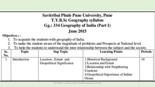
Location, extent, Historical background of India,
- 1. LM Thakare - Location, extent, historical background of Inda
- 2. LOCATION • The Indian landmass has a central location between the East and the West Asia. • India is a southward extension of the Asian Continent. Lying entirely in the Northern hemisphere, India also accounts for 2.4% of the area on the globe, LM Thakare - Location, extent, historical background of Inda
- 3. • India is divided by Tropic of Cancer 23°30′ N in almost two equal parts. • The upper half has a temperate cooler climate and the lower half has a tropical climate. • The Southernmost point of the Indian union is known as ‘Indira point‘, however, that was submerged in 2004 Tsunami. • In the south-east of India, Andaman and Nicobar islands lie in the Bay of Bengal. • In southwest Lakshadweep islands LOCATION LM Thakare - Location, extent, historical background of Inda
- 4. India is enormous in size, it is the 7th largest country in the terms of landmass. The total area of India is 3.28 million square km. India also accounts for 2.4% of the area on the globe, with a land boundary of 15,200 km and the coastal boundary that includes the islands is 7,516 km. LOCATION LM Thakare - Location, extent, historical background of Inda
- 5. Extent of India North –South extension West - east extension It has a land frontier of 15,200 km and a coastline of 7,516.6 km • India measures 3,214 km • 2,933 km from east to west. • east-west stretch is smaller than the north- south stretch. The main land extends between latitudes 8°4'N and 37°6'N and longitudes 68°7'E and 97°25'E. LM Thakare - Location, extent, historical background of Inda
- 6. SOUTH-WEST by the Arabian Sea SOUTH-EAST by the Bay of Bengal NORTH, NE, and NW are the Himalayas. SOUTHERN TIP is Kanyakumari (Indian peninsula) • The Southernmost point of the Indian union is known as ‘Indira point‘, however, that was submerged in 2004 Tsunami. Boundaries of India - Natural LM Thakare - Location, extent, historical background of Inda
- 7. Boundaries of India - neighbours • India shares borders with seven sovereign countries • shares land borders with China, Bhutan, Nepal ,Pakistan in the north or north-west, • Bangladesh and Myanmar in the east. • India also shares water borders with SriLanka, Maldives and Indonesia LM Thakare - Location, extent, historical background of Inda
- 8. India’s Relationship with her Neighbors LM Thakare - Location, extent, historical background of Inda
- 9. Locational Advantage: • India is a unique country as it is easily accessible to other parts of Asia, Africa, Europe and Americas. Its cultural influences have crossed its border from time immemorial and reached far off lands. • It acts as a bridge head between developed and developing countries of the world and between the East and the West. • India’s strength lies in its geography as much as in its culture. Since the opening of the Suez Canal in 1869, distance between India and Europe has been reduced by 7000 kms. India enjoys a favourable situation on the international highway of trade and commerce. • The ocean routes from East and South-East Asia and Australia to Africa and Europe pass through Indian Ocean. India is connected with Europe, North America and South America through both the routes-the Cape of Good Hope and the Suez Canal. India can also reach Canada and the U.S.A. through the Strait of Malacca after crossing the Pacific Ocean.LM Thakare - Location, extent, historical background of Inda
- 10. India’s Relationship with her Neighbors India has a long land frontier and coastline. It shares boundaries with Pakistan, Nepal, Bhutan, China, Bangladesh, Myanmar (Burma) and Sri Lanka. India has adopted a foreign policy of neutrality and non-involvement. India and South Asia: South Asian Association for Regional Cooperation (SAARC) South Asia comprises the countries lying to the south of the Himalayas and the Hindu Kush mountains. India, Pakistan, Nepal, Bhutan, Bangladesh, Maldives and Sri Lanka are the countries belonging to the region. Most of these countries were previously ruled by the British. They have similar cultures, social habits and economic problems. The South Asian Association for Regional Cooperation (SAARC) is the regional intergovernmental organization and geopolitical union of states in South Asia. Its member states include Afghanistan, Bangladesh, Bhutan, India, Maldives, Nepal, Pakistan and Sri Lanka. SAARC comprises 3% of the world's area, 21% of the world's population and 3.8% of the global economy.(2015) All these countries face problems arising out of overpopulation, poverty, malnutrition, illiteracy etc. It is believed that these countries of South Asia could progress fast only through cooperation with each other and by devising common plans for development. This concept led to the formation of the South Asian Association for Regional Cooperation (SAARC) with the objective of mutual economic and social development. LM Thakare - Location, extent, historical background of Inda
- 11. • The Association of South-East Asian Nations (ASEAN): • The South-East Asian countries of Malaysia, Myanmar (Burma), Thailand and Vietnam are economically important countries. While Myanmar, Thailand and Vietnam are rice- producing countries, Malaysia produces rubber. • Possibly for fear of communist domination, the governments of Indonesia, Malaysia, Thailand, Philippines and Singapore formed the Association of South-East Asian Nations (ASEAN) in 1967. It was decided to make the region a “Zone of Peace, Freedom and Neutrality”. Later on Brunei, Vietnam, Myanmar and Laos joined the ASEAN. • The ASEAN was founded with the objective of accelerating economic growth, social progress and cultural development in the region. It sought dialogue with the powerful nations of the world in order to attract investment. These nations were called “Dialogue Partners”. LM Thakare - Location, extent, historical background of Inda
- 12. India and China: When the Communists came to power in China, India had welcomed the change and was one of the first countries to recognise her. She also advocated China’s admission to the UN. In 1954, Indian Prime Minister Jawaharlal Nehru and the Chinese Prime Minister, Chou- en-lai, had signed the “Panchsheel” agreement. They adopted five principles: 1. Mutual respect for each other’s territorial integrity and sovereignty. 2. Mutual non-aggression. 3. Mutual non-interference in each other’s internal affairs. 4. Equality and mutual benefit. 5. Peaceful coexistence. In spite of this, in 1962, China attacked India in the North-East and occupied a part of Indian Territory. The war ended soon but relations between India and China remained strained for a long time to come. The visits of the Indian Prime Ministers Rajiv Gandhi (in 1988) and Narasimha Rao (in 1993) to China have improved the situation to some extent. Several trade agreements have also been signed. But it is not an easy task to restore peace and mutual trust between the two countries. IN 2010 The main cause of the war was a dispute over the sovereignty of the widely separated Aksai Chin and Arunachal Pradesh border regions. Aksai Chin, claimed by India to belong to Kashmir and by China to be part of Xinjiang, contains an important road link that connects the Chinese regions of Tibet and Xinjiang On 16 June 2017 Chinese troops with construction vehicles and road-building equipment began extending an existing road southward in Doklam, a territory which is claimed by both China as well as India's ally Bhutan On 10 May 2020, Chinese and Indian troops clashed in Nathu La, Sikkim, leaving 11 soldiers injured LM Thakare - Location, extent, historical background of Inda
- 13. India and Nepal: Being a small landlocked country, Nepal depends on India for economic support and transit facilities. Almost all of her imports pass through Indian ports. India has made a significant contribution to economic and social developments of Nepal. She built the 204 km long Mahendra Raj Marg to link Kathmandu and India. Agreements have been signed for greater cooperation in trade, education, industrial development and cultural exchange programmes. There are very few travel restrictions between India and Nepal. Nepalese workers are employed in India and Nepalese students study in Indian universities. India and Bhutan: Bhutan, a small Himalayan kingdom, is one of the poorest countries of the world. India has helped Bhutan in her telecommunication and hydroelectric projects and in the construction of hospitals, roads and bridges. India and Myanmar Myanmar (Burma), which was a part of British India, became independent in 1948. Since India and Myanmar share common boundaries, they have to face problems of smuggling and illegal migration. Rajiv Gandhi visited Myanmar in 1987 and the two countries agreed to solve these problems through greater vigilance. India supports Aung-San Suu Kyi, the Nobel peace prize winner who is the leader of the democratic movement in Myanmar. LM Thakare - Location, extent, historical background of Inda
- 14. India and Pakistan: In 1947, India was partitioned and the country of Pakistan was born. The two countries share the same historical, linguistic and cultural heritage. Yet, ever since independence, relations between the two countries are marked by hostilities. The Kashmir Issue: The Kashmir problem had begun from 1947, the year of our independence. The Mountbatten Plan had given the Indians States the option of joining either India or Pakistan or remaining independent. When the British left India, Pakistan attacked Kashmir and occupied a part of the Kashmir Valley. The Maharaja of Kashmir decided to join India and signed the instrument of accession. The Indian army moved into Kashmir and pushed back the invaders. After UN intervention, North-West Kashmir was controlled by Pakistan and the rest of the state was placed under Indian control. The Indo-Pak War (1965): In August 1965, Pakistan made another attempt to seize Kashmir. A war started. After UN intervention, a truce was declared and an agreement (the Tashkent Agreement) was signed in 1966. But cordiality and friendship were not established. LM Thakare - Location, extent, historical background of Inda
- 15. The Indo-Pak War (1971): Hostilities between India and Pakistan again started in 1971 when India helped Bangladesh to become independent. By the Simla Agreement (1972), Prime Minister Indira Gandhi of India and Z.A. Bhutto of Pakistan agreed to settle all problems peacefully. However, relations between India and Pakistan continue to remain strained. Kargil War (1999): War again broke out between the two countries when Pakistan occupied portions of Indian Territory in the Kargil area. India defeated Pakistan. Relations between India and Pakistan further worsened because of Pakistan’s involvement in terrorist activities in various parts of India, especially in the Punjab and Kashmir. This cross- border terrorism instigated by Pakistan is a grave threat to India’s security. Restraint, understanding and cooperation are needed for the establishment of lasting peace in this region. 2016 in September 2016, the Indian military announced it had carried out “surgical strikes” on terrorist camps inside Pakistani- controlled territory across the Line of Control, while the Pakistani military denied that any such operation had taken place. 2019 India and Pakistan continued to exchange fire along the border in Kashmir, resulting in dozens of military and civilian casualties on both sides. 2019 India–Pakistan standoff: On 14 February 2019, a suicide attack on convoy of India's CRPF resulted in death of at least 40 troops. LM Thakare - Location, extent, historical background of Inda
- 16. India and Bangladesh: In 1971, a civil war broke out between the people of East Pakistan and West Pakistan. India helped East Pakistan in her war of independence against West Pakistan. In 1971, East Pakistan became independent with India’s support. A new nation, Bangladesh, was born under Mujibur Rehman. Subsequently, India helped Bangladesh to set her economy on a sound footing by giving her loans and technical assistance. She also sent relief to Bangladesh during natural calamities like flood and drought. Relations with Bangladesh deteriorated over the sharing of the water of the River Ganges and the refugee problem. In 1990 the two countries entered into an arrangement covering various aspects of trade and sharing of water. A 30-year treaty has been signed between the two countries over the sharing of the water of the Ganges (1996). India and Sri Lanka: India has cultural, historical and religious ties with Sri Lanka. Sri Lanka is facing a civil war in her northern provinces. A predominantly Tamil Hindu population of northern Sri Lanka started a movement demanding an independent state. This powerful separatist movement is led by the Liberation Tigers of Tamil Eelam (LTTE). India, on the request of the Government of Sri Lanka sent a peace-keeping force there to restore normalcy. The Indian forces were withdrawn after three years (1990) without restoring peace. India wants Sri Lanka to find a solution to her conflict with the Tamils who are fighting for independence. Rajiv Gandhi himself became a victim of this unresolved crisis when he was assassinated in 1991. Cordial relations have been restored between the two countries. As member states of the SAARC, both countries are working together on developmental issues. India and the Maldives: The republic of Maldives is a group of islands in the Indian Ocean. India shares a close and cordial relationship with Maldives. Trade and tourism are being developed between the two countries. LM Thakare - Location, extent, historical background of Inda
- 17. Q 1. How many neighbouring countries of India? Q 2. Which country have the longest boundary with India? Q 3. Which country have the shortest boundary with India? Q 4. How many states share boundary with China? Q 5. How many states share boundary with Bangladesh? LM Thakare - Location, extent, historical background of Inda
- 18. LM Thakare - Location, extent, historical background of Inda
- 19. LM Thakare - Location, extent, historical background of Inda
- 20. China is India's largest trading partner. Chinese imports from India amounted to $16.4 billion or 0.8% of its overall imports, and 4.2% of India's overall exports in 2014. The 10 major commodities exported from India to China were:[149][150] 1.Cotton 2.Gems, precious metals, 3.Copper: 4.Ores, slag, ash: Organic chemicals: 5.Salt, sulphur, stone, cement 6.Machines, engines, pumps: 7.Plastics: 8.Electronic equipment: 9.Raw hides excluding furskins: LM Thakare - Location, extent, historical background of Inda
- 21. Chinese exports to India amounted to $58.4 billion or 2.3% of its overall exports, and 12.6% of India's overall imports in 2014. The 10 major commodities exported from China to India were 1. Electronic equipment: 2. Machines, engines, pumps: 3. Organic chemicals 4. Fertilizers: 5. Iron and steel: 6. Plastics: 7. Iron or steel products: 8. Gems, precious metals, coins: 9. Ships, boats: 10.Medical, technical equipment: LM Thakare - Location, extent, historical background of Inda
- 22. Historical background of India LM Thakare - Location, extent, historical background of Inda
- 23. Indian History - Brief LM Thakare - Location, extent, historical background of Inda
- 24. LM Thakare - Location, extent, historical background of Inda
- 25. LM Thakare - Location, extent, historical background of Inda
- 26. LM Thakare - Location, extent, historical background of Inda
- 27. Invasion of Ghuris -Ghazni LM Thakare - Location, extent, historical background of Inda
- 28. LM Thakare - Location, extent, historical background of Inda
- 29. LM Thakare - Location, extent, historical background of Inda
- 30. 1953, States LM Thakare - Location, extent, historical background of Inda
- 31. 1941 LM Thakare - Location, extent, historical background of Inda
- 32. India today Year state 1961 MH, GJ Goa, Diu Daman 1963 Nagaland 1966 Haryana 1971 Himachal Pradesh 1972 Manipur, Tripura, Sikkim, Meghalaya 1987 Arunachal P. 2000 Chhattisgarh, Uttarakhand, Jharkhand 2014 Telangana 2020 Ladakh (UT) LM Thakare - Location, extent, historical background of Inda
- 33. Name of states, UT and capitals Historical background of India LM Thakare - Location, extent, historical background of Inda
- 34. GEO-POLITICAL IMPORTANCE OF INDIAN OCEAN LM Thakare - Location, extent, historical background of Inda
- 35. The economic upsurge of some nations and stagnation/slowdown of others is throwing up challenges that could affect the regional and international markets GEO-POLITICAL IMPORTANCE OF INDIAN OCEAN Indian Ocean is encircled by 46 Countries LM Thakare - Location, extent, historical background of Inda
- 36. 1.Trade Volume: Indian Ocean is one of the world’s busiest oceans. Today, almost 90,000 vessels in the world’s commercial fleet transport 9.84 billion tonnes per year though Indian Ocean. Also, its location at the crossroads of global trade, connecting the major international economy in the Northern Atlantic and Asia-Pacific which means that he who controls the Indian Ocean controls the trade of major economies of the world. GEO-POLITICAL IMPORTANCE OF INDIAN OCEAN LM Thakare - Location, extent, historical background of Inda
- 37. 1.Strategic Depth: Indian Ocean region connects 3 continents (Africa, Asia and Australia) and 2 Oceans (Atlantic and Pacific) with each other. • In other words, if the security of this region gets compromised, then economic activities on more than 50% of the globe will be stalled. Having said that, the one who controls the Indian Ocean will control all these economic activities. • Moreover, the Indian Ocean is the battleground for some of the key sea lanes in the world like- Malacca Strait and Strait of LM Thakare - Location, extent, historical background of Inda
- 38. 1.The OIL angle: Majority of crude oil is imported from the gulf countries. 2.The route of this oil passes through the Strait of Hormuz into the Arabian sea and subsequently into the Indian Ocean. 3.So, it is safe to say that majority of oil is transferred to their destination through Indian Ocean region 4.This is the sole reason of China trying to find an alternative route though China-Pakistan Economic corridor (CPEC) because 70% of its oil is transferred though Indian Ocean where Indian Navy has a strong presence. 5.Large Drainage Basin: The Ocean’s vast drainage basin is important in its own right, home to some two billion people. 6.This creates opportunities, especially given the high rates of economic growth around the Indian Ocean rim, including in India, Bangladesh, Southeast Asia, and Eastern and Southern Africa. GEO-POLITICAL IMPORTANCE - 2 LM Thakare - Location, extent, historical background of Inda
- 39. Strait of Hormuz Strait of Malacca Strait of Malacca LM Thakare - Location, extent, historical background of Inda
- 40. 1.Natural Resources: Finally, the Indian Ocean is rich in natural resources. 2.Forty per cent of the world’s offshore oil production takes place in the Indian Ocean basin. 3.Persian Gulf 4.SE Asian countries – Indonesia, Malaysia 5.Australian coast. 6.KGB –Krishna Godavari basin GEO-POLITICAL IMPORTANCE - 3 Gas exploration Drilling ProductionLM Thakare - Location, extent, historical background of Inda
- 41. • This region is rich in Fishing and other Aquaculture activities. Mineral resources are equally important, with nodules containing nickel, cobalt, and iron, and massive sulfide deposits of manganese, copper, iron, zinc, silver, and gold present in sizable quantities on the sea bed. Indian Ocean coastal sediments are also important sources of titanium, zirconium, tin, zinc, and copper. Additionally, various rare earth elements are present, even if their extraction is not always commercially feasible. Konkan n Malabar coast – Atomic minerals – Uranium and Thorium deposits.LM Thakare - Location, extent, historical background of Inda
- 42. Indian Ocean is also home to many island countries like- Mauritius, Maldives, Seychelles, Madagascar etc. whose entire economy is dependent on the ecosystem of the waters near them. GEO-POLITICAL IMPORTANCE - 4 LM Thakare - Location, extent, historical background of Inda
- 43. THANK YOU.. Q. Write in 50 words: 1. Natural boundaries of India. 2. Political boundaries of India. LM Thakare - Location, extent, historical background of Inda