![ The earliest archaeological signs of permanent settlements in the
Paris area date from around 4200 BC.[21]
The Parisii, a sub-tribe of the Celtic Senones, inhabited the area
near the river Seine from around 250 BC.[22]
The Romans conquered the Paris basin in 52 BC,[21] with a
permanent settlement by the end of the same century on the Left
Bank Sainte Geneviève Hill and the Île de la Cité.
The Gallo-Roman town was originally called Lutetia, but later
Gallicised to Lutèce
It expanded greatly over the following centuries, becoming a
prosperous city with a forum, palaces, baths, temples, theatres, and
an amphitheatre.
The collapse of the Roman empire and the 5th-century Germanic
invasions sent the city into a period of decline.
By 400 AD, Lutèce, largely abandoned by its inhabitants, was little
more than a garrison town entrenched into a hastily fortified central
island.
The city reclaimed its original appellation of "Paris" towards the end
of the Roman occupation
origin](data:image/gif;base64,R0lGODlhAQABAIAAAAAAAP///yH5BAEAAAAALAAAAAABAAEAAAIBRAA7)
Recommended
More Related Content
What's hot
What's hot (20)
Similar to city of paris.ppt
Similar to city of paris.ppt (20)
Recently uploaded
Recently uploaded (20)
city of paris.ppt
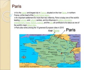
- 1. Paris It is the capital and largest city in France, situated on the river Seine, in northern France, at the heart of the Île-de-France region . An important settlement for more than two millennia, Paris is today one of the world's leading business and cultural centres, and its influences in politics, education, entertainment, media, fashion, science, and the arts all contribute to its status as one of the world's major global cities. Paris also ranks among the 10 greenest European cities in 2010 Paris river Seine
- 2. The earliest archaeological signs of permanent settlements in the Paris area date from around 4200 BC.[21] The Parisii, a sub-tribe of the Celtic Senones, inhabited the area near the river Seine from around 250 BC.[22] The Romans conquered the Paris basin in 52 BC,[21] with a permanent settlement by the end of the same century on the Left Bank Sainte Geneviève Hill and the Île de la Cité. The Gallo-Roman town was originally called Lutetia, but later Gallicised to Lutèce It expanded greatly over the following centuries, becoming a prosperous city with a forum, palaces, baths, temples, theatres, and an amphitheatre. The collapse of the Roman empire and the 5th-century Germanic invasions sent the city into a period of decline. By 400 AD, Lutèce, largely abandoned by its inhabitants, was little more than a garrison town entrenched into a hastily fortified central island. The city reclaimed its original appellation of "Paris" towards the end of the Roman occupation origin
- 3. Development of Paris This 1705 map shows the intersection of two movement system on what is now ile de la cite, where the old roman road crossed the River seine. This leads to forming the frame of orientation for the classical Roman city.
- 4. Development of Paris • The lower map shows the medieval Paris as it was from 1367 to 1383. • Here the ancient crossing determines the center was tightly developed town, the wall defining area of intensity at the juncture of the movement system. • The inner line shows the position of the first walls built north of the river. • These were moved away from the place by Philip Augustus in 1223 to the position . • The pressure of city growth continued and the walls were further extended under Charles v and Charles vi to the position.
- 5. For the next two centuries the development of Paris continued to be largely contained within the walls, and these were extended still by Louis xiii In 1563 Catherine de medicis introduced a new idea of Italian derivation, that of constructing pleasure gardens outside the city wall . This led to further extension and finally to the breaching of the wall all together and the brilliant axial extension of the old Medici gardens by the French landscape architect Andre le Notre. This set in to motion a thrust of design which carry energy, previously compressed within the walls across the country side .the seventeenth century Gabriel perelle engraving of the Tuileries gardens and the embryonic champs Elysees depicts the hitherto unknown idea of a design element disappearing over the horizon.
- 6. PARIS THE EXPLOISION •The louvre palace We can see, in successive stages the superimposition of italian ideas on medieval-paris And the consequent unleashing of forces of a magnitude unknown in italy. The plan shows Paris as it was in 1300, medieval walled city developed around the crossing of the river seine. the louvere palace outside the walls, shown in black, is the point in origin of the design forces, the development of which is showed in these drawings.
- 7. •The plan shows Paris as it was in 1600,the white line indicating the position of the walls of 1300 north of the seine, the gray showing the outward extension to the new walls responding to the pressures of the city growth Bastille louvres Tuileries palace Row of tress •To the east in black is shown the Bastille, and in green the row of trees planted along the wall, the first indication of the great tree-lined boulevard system to follow. •the old louvere,now completely surrounded by city development, is in process of rebuilding. Outside the new walls to the west is the Tuileries palace, built by Catherine de medicis,wife of Henry II,originally conceived as a self contained, independent structure. •To the west of this extends the Tuileries gardens, still medieval in design with their directionless form of planting beds, yet heralding a new integration of city and country side.
- 8. This map of 1740 shows the maturing of Paris under Louis xv.Here the great concept of Le Notre extending the axis of the Tuileries gardens in the form of the great champs Elysees,has become a dominant design element of Paris. The yellow lines show the later extension across the river siene.the Tuileries palace has been connected with the louvere by the grand gallery built by Henry IV,providing a counterfoil for the axial thrust deeply embedded in the city. The old ramparts have been planted as continues tree lined boulevards, carrying forward the idea furthered by Marie de Medici’s wife of henryIV,in her pleasure drive,cours lareine,developed along the seine west ward from the Tuileris gardens.
- 9. The whole nature of the tuileries design is transformed from static to dynamic, and the thrust of the axis generated within the garden is extended outward by the avenue des tuileries, now the champs Ely sees. Not yet present is the place de la Concorde, which was later to occupy the open ground between the Tuileries garden wall and the planted area of the champs Ely sees and would connect the central tuileries garden axis with the area both to the east and across the river seine. These drawings show the beginning and development of a regional design idea,and they demonstrate,too,how a regional form can have its root in so simple a matter as the shape of a garden plot.
- 10. Once the idea of the thrust of axial extension had been established by construction and planting on ground, became a dominant element in the later development of pairs and applied With much skill by many designers over the years. The river seine provided the central spine for design growth. From it were extended perpendicularly a series of axial developments , notably the esplanade of the invalids and the champ de mars with the Eiffel tower. The pattern formed by them is strikingly similar to the designs by Paul knee. These developments were gradually interlaced and other boulevard extension, forming the beginning of a regional network. Napoleon one set about to clear out old structures in the area that became the courtyard Of the Louvre, and he ordered the realigning and completion of streets in neighboring sections. But it was napoleon 3 and the achievements of baron Georges Haussmann that led to the reintegration of the heart of pairs and strengthening of its interior structure on a scale commensurate with the forces of regional expansion. This reversal of direction of energy, from outward explosion of the avenues and palaces of the Louis kings to the implosion the connecting and life-giving boulevards of Haussmann, is one of the most dramatic in any city . Each development was devised and inspired by social and economic forces far different from those prevailing today, but each has proved to be resilient ,to be capable of providing a structure suited to modern needs. Design structure of Paris
- 11. The map of 1740,gives a glimpse of the kind of quality the Paris region must have had when the entire area was dominated by a network of interlaced axes.