SlideShare a Scribd company logo
1 of 12
Download to read offline
Detailed Stratigraphic succession, Lithology, Structure and Tectonics
and Mineral Resources of Meghalaya
By – Kalpajyoti Mazumdar
M.Sc 2nd
sem, Assam University, Silchar
Introduction:
Shillong Plateau which is also known as Meghalaya Plateau is a part of the Indian Shield (Evans 1964). This
plateau is bounded by the Dauki fault to the south, Kopili fault to the east, Brahmaputra fault to the north
and Dhubri fault to the west. It covers an area of about 25,000 km2 and criss-crossed by many faults. It is
separated from Indo-Myanmar Mobile belt by NE-SW trending belt of Schuppen and from Eastern
Himalayas by Brahmaputra River. It behaves like an independent entity and shows its own nature of faulting
and seismicity that is distinct from Himalayan thrust front. Shillong Plateau lies between Himalaya belt
(north) and Indo-Myanmar mobile belt (east) and has experienced compressive tectonic forces from
orthogonal directions of two orogenies .
Geologically, Shillong Plateau comprises of rocks from the oldest Precambrian gneissic complex to the
recent alluvium formations. Bouger anomaly map shows gravity high over Shillong Plateau. It indicates
presence of high density basement rocks at shallow depths. About 1.5-3.5 mm/yr of the present-day N-S
convergence in the Eastern Himalaya is accommodated in Shillong Plateau. The 1897 Great Shillong
earthquake occurred at western edge of the Shillong Plateau and it uplifted the northern part of it about 10m.
The Shillong Plateau is tectonically very active due to the collision of the Indian plate with Tibetan
landmass in the north and subduction process between the Indian plate and the Shan Tenasserim block in the
east. Shillong Plateau detached from Indian Peninsula by a large scale Garo Rajmahal tectonic basin. It is
also believed that within the Shillong Plateau an intra-cratonic depression formation took place in the central
and eastern part of Meghalaya during Proterozoic time where mainly Shillong Group of rocks were
deposited over gneissic complex .This rift related basin is named as Shillong basin. Later, these rocks were
metamorphosed into metavolcanic and metasedimentary rocks. The evidence of K/T volcanism in this
plateau is Sylhet Trap where it occurs at southern margin of the plateau through E-W trending Dauki fault.
After Sylhet Traps eruption, marine transgression took place and sedimentary rocks of Upper Cretaceous-
Cenozoic deposited. Shillong Plateau started upliftment since Tertiary period and moved horizontally
eastwards along Dauki fault from the Indian peninsular Shield to its present position during Miocene to
Pliocene .
Lithostratigraphy of Meghalaya:
1. Palaeo Proterozoic- Archaean Basement:
Shillong Plateau exposes different kinds of rocks. Precambrian rocks of Gneissic composition are the oldest
rocks found here and considered to be basement complex. This basement complex consists of biotite-gneiss,
biotite-hornblende gneiss, graniticgneiss, mica-schist, biotite granulite-amphibolite, pyroxene granulite,
gabbro and diorite. It is unconformably overlain by Shillong Group.
2. Shillong Group Of Rocks & Neo-Proterozoic Intrusives
Shillong Group is named after the capital city of Meghalaya i.e. Shillong. CGWB (2009) classified Shillong
Group into Upper Shillong Formation (mid-Proterozoic) and Lower Shillong Formation (early Proterozoic).
Upper Shillong Group is also known as Upper Quartzite Formation or Shillong Formation (Barooh and
Goswami, 1972) or Mawphalang Formation (Battarcharjee and Rahman, 1985) or Shillong Formation
(Ahmed, 1981). It is well exposed at Mawphalang and it consists of mainly quartzites intercalated with
phyllite and conglomerate. The Lower Shillong Formation comprises mainly schists with calcsilicate rocks,
carbonaceous phyllite and thin quartzite layers, slate and conglomerate (fig. 1). Lower Shillong Formation is
also known as Tyrsad Formation (Barooh and Goswami, 1972) or Barapani Formation (Ahmed, 1981) or
Manai formation (Battarcharjee and Rahman, 1985) or Lower Metapelitic Formation.
Lithology of Shillong groups of rock:

Meghalaya during Proterozoic.
renaceous sediments were deposited during the mesoproterozoic period along with basic
igneous intrusions in the form of dykes and sills, which were subsequently metamorphosed into
metavolcanic and metasedimentary rocks.
mostly under greenschist to lower amphibolite facies.
i) The lower argillaceous unit/ Manai Group
ii) The upper quartzitic unit/ Mawphlang group
cover is 1530-1550 Ma.
i) Manai Group:
It is the lower clay units, metamorphosed and classed as „lower Metapelite formation‟. Two distinct
formations under this group are:
A) Mawmaram Formation: It is metapelitic, with grey and purple phyllite, garnetiferous phyllite,
quartz sericite schist, garnetiferous slate.
B) Tyrsad Formation: it is dominantly carbonaceous and metacalcareous enriched. It contains
carbonaceous quartzite, carbonaceous slate, metacalcareous rocks, feldspathic quartzite, mica and
chlorite schist.
ii) Mawphlang Group
It incorporates:
A) Upper Quartzitic Formation which includes Cross bedded and ripple marked quartzite, thin bedded
grey and purple phyllite, graded conglomerate, ferrugenous conglomerate, quartzite and sheared
conglomerate massive quartzite and Sumer-Mawmaram sheared conglomerate.
B) Khasi Greenstones: it includes Khasi basalt, ultrabasic intrusives, epidolerite, dolerite and
amphibolite. These are massive and least altered mafic intrusives.
The Manai group and the Mawphlang Group are separated by a profound conglomeratic horizon (Sumer
conglomerate)
Khasi Greenstones:
The Proterozoic mafic suite of rocks known as “Khasi greenstone” occurs as intrusives into weakly
metamorphosed Shillong Group of rocks.
Mineralogically, these are mostly Amphibolite and Meta-dolerite dykes and sills and occurs in two
broad litotypes: dominant massive types and foliated variant.
Khasi Greenstone consists of epidiorite, dolerite, amphibolite and pyroxene dykes and sills. These rocks are
mainly green in colour and hence, they are commonly known as Khasi Green stone which is named after the
major tribal group “Khasi” in Meghalaya. Its exposure is reported at south of Laitiyngkot and N-W of
Sohiong. It unconformably overlies Shillong Group and it is considered to be mid-Proterozoic age . Granite
Plutons of Proterozoic age overlies Khasi Greenstone. It is classified as Kyrdem granite (479±26Ma),
Nongpoh granite (550±15Ma), Mylliem granite (607±13Ma) and South Khasi granite (690±26Ma) based on
the age, composition and the place where they exposed.
Felsic Intrusives:
Batholith (690 Ma) and Kyrdem Granite (480
Ma) intrusive into the Shillong Group of rocks
-Feldspar as phenocrysts.
Mesozoic Magmatic Rocks:
plateau through the E-W trending dawki fault and Raibah Fault
Sylhet Trap:
ops as a 5-6 km wide strip for about 80 km along the southern margin of
Plateau.
-Cambrian basement.
f the Sylhet Trap were induced by Kerguelen Plume
Sylhet trap of Lower Cretaceous age is exposed in and around Therriaghat river
section . It is named after Sylhet city of Bangladesh. It mainly consists of vesicular basalt. It
unconformably overlies Lower Gondawana group. Sung Group overlies Sylhet trap
unconformably. Sung Group is exposed at Sung valley. The main rocks consist of Pyroxene
–serpentinite, melilite pyroxene rocks, syenite and carbonatite. The age of Sung Group is
mid-cretaceous .
Cretaceous -Tertiary Sediments:
southwestern, southeastern and eastern margin of the Shillong plateau under a stable shelf condition.
iments are mainly sandstone and shale
I. Upper Cretaceous Khasi Group
II. Palaeocene-Eocene Jaintia Group
III. Oligocene-Miocene Pliocene Garo Group
Detailed Stratigraphy Khasi Group
Khasi Group unconformably overlies the Sung Group. Khasi Group is named after “Khasi tribe”
of Meghalaya. It is divided into three formations- Mahadek (Upper cretaceous), Basal Conglomerate or
Bottom Conglomerate (Medlicott, 1869) or Weilloi Conglomerate (Bhahttacharya and Bhattacharya, 1981)
(fig. 6) and Jadukuta Formations (mid-cretaceous ). Jadukuta Formation consists of Conglomerate grit and
sandstone grit. It is well exposed in Jadukuta river section. Conglomerates with minor felspathic sandstone
lenses are the components of Basal Conglomerate. It is exposed at Tyrsad-Weilloi road section. Hence, it is
also known as Weilloi Conglomerate. Basal conglomerate is overlain by Mahadek (also known as Mahadeo:
Garg et al., 2006) Formation. It comprises arkosic sandstone (often glauconitic & uraniferous). It also
contains grey shales, mudstones and calcareous sandstone. The exposure is seen along Weilloi-Mawsynaram
road section.
It is a distinct arenaceous Group consisting of
•Mahadek Formation and
•Jadukata Formation
Jaduka Formation:
It is the lowermost unit of Khasi Group consisting of conglomerate and sandstone nonconformably
overlying the Sylhet trap.
Mahadek Formation:
U. Mahadek Fm. contains Purple colour Glauconitic Sandstone-Shale alteration.
eralizations.
Detailed Stratigraphy of Jaintia Group
Jaintia Group is divided into five formations-
I. Langpar,
II. Therria /Cherra,Tura
III. Shella and
IV. Kopili formations (Sarmah & Borgohain, 2012; Mallick et al., 1988; Saxena and Tripathi 1982 and
Dutta, 1982).
It is named after the “Jaintia tribe” of Meghalaya. Jaintia Group unconformably overlies Khasi Group.
I. Langpur Formation:
Langpar Formation is the lowermost part of the Jaintia group. It is exposed in Therriaghat (fig. 5).
Calcareous shale, sandstone and limestone are the main components of Langpar formation. It is overlain by
Therria Formation (Cherra Stage by Evans, 1932) at Therriaghat and Tura formation at Tura.
II. Therria formation
Therria Formation consists of arkosic sandstone with limestone, shale and coal whereas Tura Formation is
made up of coal bearing poorly sorted sandstone. Both Formations are overlain by Shella Formation.
III. Shella formation:
Shella Formation consists of five members-Lakadong limestone, Lakadong sandstone, Umlatadoh
limestone, Nurpuh sandstone and Prang sandstone (Sarmah & Borgohain, 2012 & Garg et al, 2006).
Lakadong limestone is grey to pink massive crystalline limestone, highly ferruginous and traversed by
calcite veins. It also contains silty shales and partings in upper part. It is exposed at Lakadong plateau.
Lakadong sandstone is fine to medium grained ferruginous, well bedded sandstone with clays and coal
seams. It is exposed at Jathang hill. Umlatadoh limestone is grey to pinkish, well bedded highly jointed, hard
and compact fossiliferous limestone. It is exposed at South of Siropi village. Nurpuh (Narpuh) sandstone is
ferruginous, medium to coarse grained sandstone. Sometimes it also contains pyrite nodules and thin
calcareous shaly bands. It is exposed at Narpuh Reserve forest. Prang sandstone is generally grey to bluish
grey and sometimes reddish in colour and breaks in rectangular. It is exposed at Prang River section.
IV. Kopili Formation:
Kopili Formation is the youngest formation of Jaintia Group. It is alteration of fine to coarse sandstone, grey
siltstone and shales with limestone bands, sometimes coal. It is considered to be formed during Paleocene to
Eocene epoch. It is exposed at Lumshnong area. It is divided into lower, middle and upper and equated to
Disang Group of Assam by Dutta (1982).
The rocks of Kopili Formation contains foraminiferal fossils indicative of Upper Eocene age.
Detailed Stratigraphy of Garo Group:
This group represents the oligocene sequence of the platform facies. It consists of
a) Simsang,
b) Baghmara and
c) Chengapara formation
a) Simsang Formation:
It is the oldest formation of the upper tertiary sediments in the Garo hills that conformably overlies the
Kopilli Formation. It consists of a cycle of massive cross bedded sand alternating with siltstone- sandstone
units
b) Baghmara Formation:
It conformably overlies the Simsang Formation. It consists of irregular beds of coarse feldspathic sand with
minor mudstone steaks, pebbles conglomerates, massive clay and silty clay beds and thin alternating beds of
mudstone and fine sand.
c) Chengapara Formation:
It conformably overlies the Baghmara Formation. it consists of poor cemented, fine-grained, micaceous
sand, blue to brown siltstone and clays with a few thin marly beds at its base.
Structure and tectonics of Shillong Plateau
Shillong Plateau is tectonically separated from Indian Peninsula and moved towards its present
position. It is surrounded and transverse by many faults and lineaments which are mostly active and younger
in age. Some of the major faults are- Dauki fault, Kopili fault, Dapsi thrust, Tyrsad-Barapani lineament,
Umngot lineament, Raibah fault, Chedrang fault, Dudhnoi fault, Oldham fault, Dhubri fault, Jamuna
(Yamuna) fault, Samin fault, Brahmaputra fault and Kulsi fault . Structural, geomorphological, geological
and geophysical data show clear evidence that the central part of the plateau, represented by higher
topographic landform is a structurally weak and tectonically active zone (Durah and Phukan, 2011).
The basement of Shillong Plateau was formed during the break up of Australia and Antarctica.
Opening of Indian Ocean between India and Australia-Antarctica started in early Cretaceous. The
exhumation of Shillong Plateau started at 9-15 Ma (Biswas et al., 2007). The presence of Late Cretaceous
continental sediments lying on the Precambrian basement in the southern part of the plateau indicates that
the basement was exposed at the surface at the end of the Cretaceous. But, during the Tertiary (3.8-3.5Ma)
the basement was submerged and buried under shallow marine and deltaic sediments and surface upliftment
started at Pleistocene (3-4 Ma) at the rates of 0.4–0.53 mm/a (Biswas et al., 2007). Tipam sandstone marks
transition between marine and continental (Najman, 2006). The present horizontal shortening rate of the
plateau is 0.65–2.3 mm/a (Biswas et al., 2007). The tectonic upliftment of the plateau led to a reorganization
of the rivers. The paleo-Brahmaputra flowed to the south of the plateau until the Miocene and was deflected
in the Pliocene to its present course behind the plateau (Uddin and Lundberg, 1999). According to Govin et
al. (2018) Brahmaputra River was redirected north and west by the rising plateau at 5.2–4.9 Ma.
Shillong Plateau is continuously uplifting and current upliftment starts from Mio-Pliocene. The major force
responsible for upliftment is N-S trending compressive force even though E-W trending compressive stress
owing to Indo-Myanmar subduction also aided the upliftment (Rao and Kumar, 1997). Shillong Plateau rises
2.5cm during the period 1910-1977 (Kailasam, 1979). The upliftment is further evidenced by straight-edged
scarps of older Brahmaputra alluvium within recent alluvium in Assam (Kailasam, 1980). On the other hand,
it is also a highly eroded area due to high precipitation. So, both upliftment and erosion take place
simultaneously and give rise to present landforms.
The upliftment of Shillong Plateau may be due to following mechanisms-
 thermal disturbance in the upper mantle (Khattri et al., 1983)
 isostatic adjustment (Kailasam, 1979)
 compressive tectonic forces (Rao and Kumar. 1997)
 the popping up of the plateau due to tectonic movement (Kayal et al, 2006; Biham and England,
2001; Rajendran et al., 2004; Saha et al. (2007)
The most accepted theory for the upheaval of the Shillong Plateau is the “pop up” of the plateau due to
tectonic movement. But, controversy arises that which faults are responsible for popping up Shillong
Plateau. Kayal et al. (2006) opined that the pop up of the Shillong Plateau was due to the Dapsi thrust in the
west and the Brahmaputra Fault in the north. Rajendran et al. (2004) claimed that the pop up structure of the
Shillong Plateau was due to the presence of the Brahmaputra fault and the Dauki fault. Biham and England
(2001) opined that the Indian plate below Shillong pop up between two bounding faults to its north and
south i.e. Dauki Fault in the south and Oldham Fault in the north. Saha et al. (2007) and Nayak et al. (2008)
claimed that two reverse faults i.e. the Dapsi thrust to the south and possibly the Oldham fault in the north
are the causes of popping up Shillong Plateau.
The Shillong Plateau rotates at 1.150/ Ma and Assam block rotates at ~1.130/Ma. As a result of it,
convergence between this plateau and Bangladesh across Dauki fault increases from 3mm/year to
>8mm/year in the east with minor dextral shear (Vermant et al, 2014). According to Jade et al. (2007),
Dauki fault has not slipped recently but Kopili fault slips at ~2.6mm/year. The slip of Kopili fault is
contributing to seismic moment accumulation (~70.74 × 10¹⁵ Nm/year) sufficient enough to drive future
earthquakes (Mw ≥ 5.17) (Barman et al., 2016). That means the Kopili fault is more active than Dauki fault.
Some important faults/lineaments in and around Shillong Plateau are given below-
Dauki fault- Dauki fault separates Shillong Plateau from Bengal basin. It is an E-W trending about 320Km
long reverse fault dipping north (Murthy et al., 1969). Some authors also claim that it has strike slip
movement. Dauki fault is thought to have started only after the Miocene (Uddin and Lundberg, 2004).
Biswas et al. (2007) estimate the rate of vertical displacement along the Dauki fault to 0.77–1.25 mm/a.
Dapsi fault- It separates the sediments of Bengal Basin to southwest of Shillong Plateau. It is NW-SE
trending 90-100Km long reverse fault with a strike slip component. (Srinivasan, 2005). It dips towards
North at >600 (Kayal et al., 2006).
Kopli fault- It separates Shillong plateau from Mikir massif. It is about 300-400Km long and about 50 Km
wide fault. It has both normal and strike slip character dipping towards Northeast direction. Kopili fault slips
dextrally at the rate of 2-3mm/year. (Biswas et al., 2007). It is one of the most seismically active faults of the
region and a major earthquake could be expected in the future. It dips towards NE at ~610 (Kayal et al.,
2012).
Dhubri fault- It separates Shillong Plateau from Indian subcontinent. It is N-S trending fault. It is believed
to be the source of 1930 Dhubri earthquake.
Brahmaputra fault system- It separates Shillong Plateau from the Himalayas. It is broadly E-W trending
fault. The Brahmaputra fault is a south dipping fault located below the Brahmaputra River in the Assam
valley to the north of the Shillong Plateau (Rajendra et al., 2004)
Oldham fault- It is a 110Km long fault dipping 57° to the south beneath the northern edge of the Shillong
Plateau (Biham and England, 2001). Biswas et al. (2007) estimate vertical slip along Oldham fault to 0-
0.68mm/a.
Umngot lineament cuts across the general NE–SW trend of the Shillong plateau. This lineament developed
during the late Jurassic– Early Cretaceous period and contains several alkaline intrusive bodies, including
the Sung Valley complex (Gupta and Sen, 1998).
Raibah Fault- It is E-W tending fault that separates Shillong Group from Sylhet Traps (Gour and Tapal,
2001). It is a southern dipping reverse fault (GSI, 2009).
Dudhnoi fault- It is about 6Km long N-S trending fault located at western part of the Shillong Plateau.
Barapani-Tyrsad Shear Zone (BTSZ) - It is N-E trending left lateral slip fault. It passes through central
and eastern part of Shillong Plateau.
Kulsi fault /Guwahati fault – It is an active NNE-SSW trending fault that lies in the central part of the
plateau. It passes through northern margin of Shillong Plateau and Guwahati city. For this reason, it is also
known as Guwahati fault. (Imsong, 2018).

More Related Content

What's hot

Lithostratigraphic units Geology By Misson Choudhury
Lithostratigraphic units Geology By Misson Choudhury Lithostratigraphic units Geology By Misson Choudhury
Lithostratigraphic units Geology By Misson Choudhury Misson Choudhury
 
Metallogenic Epoch and Province
Metallogenic Epoch and Province Metallogenic Epoch and Province
Metallogenic Epoch and Province Nikhil Sherekar
 
A seminar on ramsay classification of fold
A seminar on ramsay classification of foldA seminar on ramsay classification of fold
A seminar on ramsay classification of foldDarshan Malviya
 
Southern granulite
Southern granuliteSouthern granulite
Southern granuliteSANDIP1992
 
Types of Foliations and lineations and their characteristics
Types of Foliations and lineations and their characteristicsTypes of Foliations and lineations and their characteristics
Types of Foliations and lineations and their characteristicssruthy sajeev
 
Singhbhum Craton
Singhbhum CratonSinghbhum Craton
Singhbhum CratonAkash Naik
 
Bundelkhand craton
Bundelkhand cratonBundelkhand craton
Bundelkhand cratonPramoda Raj
 
Permian triassic boundary by priyansh dwivedi
Permian triassic boundary by priyansh dwivediPermian triassic boundary by priyansh dwivedi
Permian triassic boundary by priyansh dwivediPriyanshDwivedi4
 
SEDIMENTARY BASINS OF INDIA.pptx
SEDIMENTARY BASINS OF INDIA.pptxSEDIMENTARY BASINS OF INDIA.pptx
SEDIMENTARY BASINS OF INDIA.pptxBARKAVE BALUSAMY
 
Fault'classification of fault and mechanism of faulting
Fault'classification of fault  and mechanism of faultingFault'classification of fault  and mechanism of faulting
Fault'classification of fault and mechanism of faultingShivam Jain
 
Introduction to diagenesis
Introduction to diagenesisIntroduction to diagenesis
Introduction to diagenesisWajid09
 
Cratons of india
Cratons of indiaCratons of india
Cratons of indiamabass77
 
Metamorphic textures
Metamorphic  texturesMetamorphic  textures
Metamorphic texturesPramoda Raj
 
Proterozoic sedimentary basins of India in general
Proterozoic sedimentary basins of India in generalProterozoic sedimentary basins of India in general
Proterozoic sedimentary basins of India in generalPramoda Raj
 
Sequence stratigraphy and its applications
Sequence stratigraphy and its applicationsSequence stratigraphy and its applications
Sequence stratigraphy and its applicationsPramoda Raj
 

What's hot (20)

Stratigraphic Code
Stratigraphic CodeStratigraphic Code
Stratigraphic Code
 
Ophiolite
OphioliteOphiolite
Ophiolite
 
Lithostratigraphic units Geology By Misson Choudhury
Lithostratigraphic units Geology By Misson Choudhury Lithostratigraphic units Geology By Misson Choudhury
Lithostratigraphic units Geology By Misson Choudhury
 
Metallogenic Epoch and Province
Metallogenic Epoch and Province Metallogenic Epoch and Province
Metallogenic Epoch and Province
 
A seminar on ramsay classification of fold
A seminar on ramsay classification of foldA seminar on ramsay classification of fold
A seminar on ramsay classification of fold
 
Southern granulite
Southern granuliteSouthern granulite
Southern granulite
 
Fluid inclusion in ores
Fluid inclusion in oresFluid inclusion in ores
Fluid inclusion in ores
 
Types of Foliations and lineations and their characteristics
Types of Foliations and lineations and their characteristicsTypes of Foliations and lineations and their characteristics
Types of Foliations and lineations and their characteristics
 
Singhbhum Craton
Singhbhum CratonSinghbhum Craton
Singhbhum Craton
 
Bundelkhand craton
Bundelkhand cratonBundelkhand craton
Bundelkhand craton
 
Permian triassic boundary by priyansh dwivedi
Permian triassic boundary by priyansh dwivediPermian triassic boundary by priyansh dwivedi
Permian triassic boundary by priyansh dwivedi
 
THE ORE-BEARING FLUIDS
THE ORE-BEARING FLUIDSTHE ORE-BEARING FLUIDS
THE ORE-BEARING FLUIDS
 
SEDIMENTARY BASINS OF INDIA.pptx
SEDIMENTARY BASINS OF INDIA.pptxSEDIMENTARY BASINS OF INDIA.pptx
SEDIMENTARY BASINS OF INDIA.pptx
 
Fault'classification of fault and mechanism of faulting
Fault'classification of fault  and mechanism of faultingFault'classification of fault  and mechanism of faulting
Fault'classification of fault and mechanism of faulting
 
Introduction to diagenesis
Introduction to diagenesisIntroduction to diagenesis
Introduction to diagenesis
 
Ore bearing fluids
Ore bearing fluidsOre bearing fluids
Ore bearing fluids
 
Cratons of india
Cratons of indiaCratons of india
Cratons of india
 
Metamorphic textures
Metamorphic  texturesMetamorphic  textures
Metamorphic textures
 
Proterozoic sedimentary basins of India in general
Proterozoic sedimentary basins of India in generalProterozoic sedimentary basins of India in general
Proterozoic sedimentary basins of India in general
 
Sequence stratigraphy and its applications
Sequence stratigraphy and its applicationsSequence stratigraphy and its applications
Sequence stratigraphy and its applications
 

Similar to Detailed stratigraphic succession of meghalaya

Geodynamic Evolution of Himalayas.pptx
Geodynamic Evolution of Himalayas.pptxGeodynamic Evolution of Himalayas.pptx
Geodynamic Evolution of Himalayas.pptxRitik
 
PALAEOZOIC SUCCESSION OF SPITI.pptx
PALAEOZOIC SUCCESSION OF SPITI.pptxPALAEOZOIC SUCCESSION OF SPITI.pptx
PALAEOZOIC SUCCESSION OF SPITI.pptxRitikDhorta
 
Evolution of himalaya
Evolution of himalayaEvolution of himalaya
Evolution of himalayaShivam Jain
 
Geology and petrography of sandstone
Geology and petrography of sandstoneGeology and petrography of sandstone
Geology and petrography of sandstoneShah Naseer
 
The kohistan magmatic arc
The kohistan magmatic arcThe kohistan magmatic arc
The kohistan magmatic arcumair666
 
evolution of siwalik.pptx
evolution of siwalik.pptxevolution of siwalik.pptx
evolution of siwalik.pptxDEVANANDANPS
 
Tectonic settings of pakistan (1)
Tectonic settings of pakistan (1)Tectonic settings of pakistan (1)
Tectonic settings of pakistan (1)MuhammadJawwad28
 
Development of Indian Coast
Development of Indian CoastDevelopment of Indian Coast
Development of Indian CoastAmber Bhaumik
 
Shah fahad report(Salt range)
Shah fahad report(Salt range)Shah fahad report(Salt range)
Shah fahad report(Salt range)junaid57148sh
 
Neogene sedimentary fringe (2012)
Neogene sedimentary fringe (2012)Neogene sedimentary fringe (2012)
Neogene sedimentary fringe (2012)KYI KHIN
 
Introduction
IntroductionIntroduction
Introductionkashif008
 
Geology of bangladesh
Geology of bangladeshGeology of bangladesh
Geology of bangladeshShuvo Roy
 
Dharwar super group
Dharwar super groupDharwar super group
Dharwar super groupharoon97123
 
Geological Field Report of Gilgit Baltistan
Geological Field Report of Gilgit BaltistanGeological Field Report of Gilgit Baltistan
Geological Field Report of Gilgit BaltistanAsim Mujtaba
 
Day 1 in khewra gorge
Day 1 in khewra gorgeDay 1 in khewra gorge
Day 1 in khewra gorgekashif008
 

Similar to Detailed stratigraphic succession of meghalaya (20)

West himalaya
West himalayaWest himalaya
West himalaya
 
Geodynamic Evolution of Himalayas.pptx
Geodynamic Evolution of Himalayas.pptxGeodynamic Evolution of Himalayas.pptx
Geodynamic Evolution of Himalayas.pptx
 
PALAEOZOIC SUCCESSION OF SPITI.pptx
PALAEOZOIC SUCCESSION OF SPITI.pptxPALAEOZOIC SUCCESSION OF SPITI.pptx
PALAEOZOIC SUCCESSION OF SPITI.pptx
 
Evolution of himalaya
Evolution of himalayaEvolution of himalaya
Evolution of himalaya
 
Geology and petrography of sandstone
Geology and petrography of sandstoneGeology and petrography of sandstone
Geology and petrography of sandstone
 
The kohistan magmatic arc
The kohistan magmatic arcThe kohistan magmatic arc
The kohistan magmatic arc
 
evolution of siwalik.pptx
evolution of siwalik.pptxevolution of siwalik.pptx
evolution of siwalik.pptx
 
Siwalik Supergroup
Siwalik SupergroupSiwalik Supergroup
Siwalik Supergroup
 
Tectonic settings of pakistan (1)
Tectonic settings of pakistan (1)Tectonic settings of pakistan (1)
Tectonic settings of pakistan (1)
 
Development of Indian Coast
Development of Indian CoastDevelopment of Indian Coast
Development of Indian Coast
 
Shah fahad report(Salt range)
Shah fahad report(Salt range)Shah fahad report(Salt range)
Shah fahad report(Salt range)
 
Salt range field report
Salt range field reportSalt range field report
Salt range field report
 
Neogene sedimentary fringe (2012)
Neogene sedimentary fringe (2012)Neogene sedimentary fringe (2012)
Neogene sedimentary fringe (2012)
 
Introduction
IntroductionIntroduction
Introduction
 
Geology of bangladesh
Geology of bangladeshGeology of bangladesh
Geology of bangladesh
 
Dharwar super group
Dharwar super groupDharwar super group
Dharwar super group
 
Geological Field Report of Gilgit Baltistan
Geological Field Report of Gilgit BaltistanGeological Field Report of Gilgit Baltistan
Geological Field Report of Gilgit Baltistan
 
palaeozoic
 palaeozoic palaeozoic
palaeozoic
 
Himalayas (3)
Himalayas (3)Himalayas (3)
Himalayas (3)
 
Day 1 in khewra gorge
Day 1 in khewra gorgeDay 1 in khewra gorge
Day 1 in khewra gorge
 

Recently uploaded

Tatlong Kwento ni Lola basyang-1.pdf arts
Tatlong Kwento ni Lola basyang-1.pdf artsTatlong Kwento ni Lola basyang-1.pdf arts
Tatlong Kwento ni Lola basyang-1.pdf artsNbelano25
 
How to Manage Call for Tendor in Odoo 17
How to Manage Call for Tendor in Odoo 17How to Manage Call for Tendor in Odoo 17
How to Manage Call for Tendor in Odoo 17Celine George
 
AIM of Education-Teachers Training-2024.ppt
AIM of Education-Teachers Training-2024.pptAIM of Education-Teachers Training-2024.ppt
AIM of Education-Teachers Training-2024.pptNishitharanjan Rout
 
80 ĐỀ THI THỬ TUYỂN SINH TIẾNG ANH VÀO 10 SỞ GD – ĐT THÀNH PHỐ HỒ CHÍ MINH NĂ...
80 ĐỀ THI THỬ TUYỂN SINH TIẾNG ANH VÀO 10 SỞ GD – ĐT THÀNH PHỐ HỒ CHÍ MINH NĂ...80 ĐỀ THI THỬ TUYỂN SINH TIẾNG ANH VÀO 10 SỞ GD – ĐT THÀNH PHỐ HỒ CHÍ MINH NĂ...
80 ĐỀ THI THỬ TUYỂN SINH TIẾNG ANH VÀO 10 SỞ GD – ĐT THÀNH PHỐ HỒ CHÍ MINH NĂ...Nguyen Thanh Tu Collection
 
On National Teacher Day, meet the 2024-25 Kenan Fellows
On National Teacher Day, meet the 2024-25 Kenan FellowsOn National Teacher Day, meet the 2024-25 Kenan Fellows
On National Teacher Day, meet the 2024-25 Kenan FellowsMebane Rash
 
Spellings Wk 4 and Wk 5 for Grade 4 at CAPS
Spellings Wk 4 and Wk 5 for Grade 4 at CAPSSpellings Wk 4 and Wk 5 for Grade 4 at CAPS
Spellings Wk 4 and Wk 5 for Grade 4 at CAPSAnaAcapella
 
Wellbeing inclusion and digital dystopias.pptx
Wellbeing inclusion and digital dystopias.pptxWellbeing inclusion and digital dystopias.pptx
Wellbeing inclusion and digital dystopias.pptxJisc
 
COMMUNICATING NEGATIVE NEWS - APPROACHES .pptx
COMMUNICATING NEGATIVE NEWS - APPROACHES .pptxCOMMUNICATING NEGATIVE NEWS - APPROACHES .pptx
COMMUNICATING NEGATIVE NEWS - APPROACHES .pptxannathomasp01
 
Beyond_Borders_Understanding_Anime_and_Manga_Fandom_A_Comprehensive_Audience_...
Beyond_Borders_Understanding_Anime_and_Manga_Fandom_A_Comprehensive_Audience_...Beyond_Borders_Understanding_Anime_and_Manga_Fandom_A_Comprehensive_Audience_...
Beyond_Borders_Understanding_Anime_and_Manga_Fandom_A_Comprehensive_Audience_...Pooja Bhuva
 
Graduate Outcomes Presentation Slides - English
Graduate Outcomes Presentation Slides - EnglishGraduate Outcomes Presentation Slides - English
Graduate Outcomes Presentation Slides - Englishneillewis46
 
Basic Intentional Injuries Health Education
Basic Intentional Injuries Health EducationBasic Intentional Injuries Health Education
Basic Intentional Injuries Health EducationNeilDeclaro1
 
NO1 Top Black Magic Specialist In Lahore Black magic In Pakistan Kala Ilam Ex...
NO1 Top Black Magic Specialist In Lahore Black magic In Pakistan Kala Ilam Ex...NO1 Top Black Magic Specialist In Lahore Black magic In Pakistan Kala Ilam Ex...
NO1 Top Black Magic Specialist In Lahore Black magic In Pakistan Kala Ilam Ex...Amil baba
 
How to Manage Global Discount in Odoo 17 POS
How to Manage Global Discount in Odoo 17 POSHow to Manage Global Discount in Odoo 17 POS
How to Manage Global Discount in Odoo 17 POSCeline George
 
TỔNG ÔN TẬP THI VÀO LỚP 10 MÔN TIẾNG ANH NĂM HỌC 2023 - 2024 CÓ ĐÁP ÁN (NGỮ Â...
TỔNG ÔN TẬP THI VÀO LỚP 10 MÔN TIẾNG ANH NĂM HỌC 2023 - 2024 CÓ ĐÁP ÁN (NGỮ Â...TỔNG ÔN TẬP THI VÀO LỚP 10 MÔN TIẾNG ANH NĂM HỌC 2023 - 2024 CÓ ĐÁP ÁN (NGỮ Â...
TỔNG ÔN TẬP THI VÀO LỚP 10 MÔN TIẾNG ANH NĂM HỌC 2023 - 2024 CÓ ĐÁP ÁN (NGỮ Â...Nguyen Thanh Tu Collection
 
Unit 3 Emotional Intelligence and Spiritual Intelligence.pdf
Unit 3 Emotional Intelligence and Spiritual Intelligence.pdfUnit 3 Emotional Intelligence and Spiritual Intelligence.pdf
Unit 3 Emotional Intelligence and Spiritual Intelligence.pdfDr Vijay Vishwakarma
 
Basic Civil Engineering first year Notes- Chapter 4 Building.pptx
Basic Civil Engineering first year Notes- Chapter 4 Building.pptxBasic Civil Engineering first year Notes- Chapter 4 Building.pptx
Basic Civil Engineering first year Notes- Chapter 4 Building.pptxDenish Jangid
 
HMCS Max Bernays Pre-Deployment Brief (May 2024).pptx
HMCS Max Bernays Pre-Deployment Brief (May 2024).pptxHMCS Max Bernays Pre-Deployment Brief (May 2024).pptx
HMCS Max Bernays Pre-Deployment Brief (May 2024).pptxEsquimalt MFRC
 
Simple, Complex, and Compound Sentences Exercises.pdf
Simple, Complex, and Compound Sentences Exercises.pdfSimple, Complex, and Compound Sentences Exercises.pdf
Simple, Complex, and Compound Sentences Exercises.pdfstareducators107
 
The basics of sentences session 3pptx.pptx
The basics of sentences session 3pptx.pptxThe basics of sentences session 3pptx.pptx
The basics of sentences session 3pptx.pptxheathfieldcps1
 
Food safety_Challenges food safety laboratories_.pdf
Food safety_Challenges food safety laboratories_.pdfFood safety_Challenges food safety laboratories_.pdf
Food safety_Challenges food safety laboratories_.pdfSherif Taha
 

Recently uploaded (20)

Tatlong Kwento ni Lola basyang-1.pdf arts
Tatlong Kwento ni Lola basyang-1.pdf artsTatlong Kwento ni Lola basyang-1.pdf arts
Tatlong Kwento ni Lola basyang-1.pdf arts
 
How to Manage Call for Tendor in Odoo 17
How to Manage Call for Tendor in Odoo 17How to Manage Call for Tendor in Odoo 17
How to Manage Call for Tendor in Odoo 17
 
AIM of Education-Teachers Training-2024.ppt
AIM of Education-Teachers Training-2024.pptAIM of Education-Teachers Training-2024.ppt
AIM of Education-Teachers Training-2024.ppt
 
80 ĐỀ THI THỬ TUYỂN SINH TIẾNG ANH VÀO 10 SỞ GD – ĐT THÀNH PHỐ HỒ CHÍ MINH NĂ...
80 ĐỀ THI THỬ TUYỂN SINH TIẾNG ANH VÀO 10 SỞ GD – ĐT THÀNH PHỐ HỒ CHÍ MINH NĂ...80 ĐỀ THI THỬ TUYỂN SINH TIẾNG ANH VÀO 10 SỞ GD – ĐT THÀNH PHỐ HỒ CHÍ MINH NĂ...
80 ĐỀ THI THỬ TUYỂN SINH TIẾNG ANH VÀO 10 SỞ GD – ĐT THÀNH PHỐ HỒ CHÍ MINH NĂ...
 
On National Teacher Day, meet the 2024-25 Kenan Fellows
On National Teacher Day, meet the 2024-25 Kenan FellowsOn National Teacher Day, meet the 2024-25 Kenan Fellows
On National Teacher Day, meet the 2024-25 Kenan Fellows
 
Spellings Wk 4 and Wk 5 for Grade 4 at CAPS
Spellings Wk 4 and Wk 5 for Grade 4 at CAPSSpellings Wk 4 and Wk 5 for Grade 4 at CAPS
Spellings Wk 4 and Wk 5 for Grade 4 at CAPS
 
Wellbeing inclusion and digital dystopias.pptx
Wellbeing inclusion and digital dystopias.pptxWellbeing inclusion and digital dystopias.pptx
Wellbeing inclusion and digital dystopias.pptx
 
COMMUNICATING NEGATIVE NEWS - APPROACHES .pptx
COMMUNICATING NEGATIVE NEWS - APPROACHES .pptxCOMMUNICATING NEGATIVE NEWS - APPROACHES .pptx
COMMUNICATING NEGATIVE NEWS - APPROACHES .pptx
 
Beyond_Borders_Understanding_Anime_and_Manga_Fandom_A_Comprehensive_Audience_...
Beyond_Borders_Understanding_Anime_and_Manga_Fandom_A_Comprehensive_Audience_...Beyond_Borders_Understanding_Anime_and_Manga_Fandom_A_Comprehensive_Audience_...
Beyond_Borders_Understanding_Anime_and_Manga_Fandom_A_Comprehensive_Audience_...
 
Graduate Outcomes Presentation Slides - English
Graduate Outcomes Presentation Slides - EnglishGraduate Outcomes Presentation Slides - English
Graduate Outcomes Presentation Slides - English
 
Basic Intentional Injuries Health Education
Basic Intentional Injuries Health EducationBasic Intentional Injuries Health Education
Basic Intentional Injuries Health Education
 
NO1 Top Black Magic Specialist In Lahore Black magic In Pakistan Kala Ilam Ex...
NO1 Top Black Magic Specialist In Lahore Black magic In Pakistan Kala Ilam Ex...NO1 Top Black Magic Specialist In Lahore Black magic In Pakistan Kala Ilam Ex...
NO1 Top Black Magic Specialist In Lahore Black magic In Pakistan Kala Ilam Ex...
 
How to Manage Global Discount in Odoo 17 POS
How to Manage Global Discount in Odoo 17 POSHow to Manage Global Discount in Odoo 17 POS
How to Manage Global Discount in Odoo 17 POS
 
TỔNG ÔN TẬP THI VÀO LỚP 10 MÔN TIẾNG ANH NĂM HỌC 2023 - 2024 CÓ ĐÁP ÁN (NGỮ Â...
TỔNG ÔN TẬP THI VÀO LỚP 10 MÔN TIẾNG ANH NĂM HỌC 2023 - 2024 CÓ ĐÁP ÁN (NGỮ Â...TỔNG ÔN TẬP THI VÀO LỚP 10 MÔN TIẾNG ANH NĂM HỌC 2023 - 2024 CÓ ĐÁP ÁN (NGỮ Â...
TỔNG ÔN TẬP THI VÀO LỚP 10 MÔN TIẾNG ANH NĂM HỌC 2023 - 2024 CÓ ĐÁP ÁN (NGỮ Â...
 
Unit 3 Emotional Intelligence and Spiritual Intelligence.pdf
Unit 3 Emotional Intelligence and Spiritual Intelligence.pdfUnit 3 Emotional Intelligence and Spiritual Intelligence.pdf
Unit 3 Emotional Intelligence and Spiritual Intelligence.pdf
 
Basic Civil Engineering first year Notes- Chapter 4 Building.pptx
Basic Civil Engineering first year Notes- Chapter 4 Building.pptxBasic Civil Engineering first year Notes- Chapter 4 Building.pptx
Basic Civil Engineering first year Notes- Chapter 4 Building.pptx
 
HMCS Max Bernays Pre-Deployment Brief (May 2024).pptx
HMCS Max Bernays Pre-Deployment Brief (May 2024).pptxHMCS Max Bernays Pre-Deployment Brief (May 2024).pptx
HMCS Max Bernays Pre-Deployment Brief (May 2024).pptx
 
Simple, Complex, and Compound Sentences Exercises.pdf
Simple, Complex, and Compound Sentences Exercises.pdfSimple, Complex, and Compound Sentences Exercises.pdf
Simple, Complex, and Compound Sentences Exercises.pdf
 
The basics of sentences session 3pptx.pptx
The basics of sentences session 3pptx.pptxThe basics of sentences session 3pptx.pptx
The basics of sentences session 3pptx.pptx
 
Food safety_Challenges food safety laboratories_.pdf
Food safety_Challenges food safety laboratories_.pdfFood safety_Challenges food safety laboratories_.pdf
Food safety_Challenges food safety laboratories_.pdf
 

Detailed stratigraphic succession of meghalaya

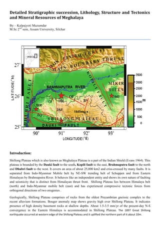
  • 1. Detailed Stratigraphic succession, Lithology, Structure and Tectonics and Mineral Resources of Meghalaya By – Kalpajyoti Mazumdar M.Sc 2nd sem, Assam University, Silchar Introduction: Shillong Plateau which is also known as Meghalaya Plateau is a part of the Indian Shield (Evans 1964). This plateau is bounded by the Dauki fault to the south, Kopili fault to the east, Brahmaputra fault to the north and Dhubri fault to the west. It covers an area of about 25,000 km2 and criss-crossed by many faults. It is separated from Indo-Myanmar Mobile belt by NE-SW trending belt of Schuppen and from Eastern Himalayas by Brahmaputra River. It behaves like an independent entity and shows its own nature of faulting and seismicity that is distinct from Himalayan thrust front. Shillong Plateau lies between Himalaya belt (north) and Indo-Myanmar mobile belt (east) and has experienced compressive tectonic forces from orthogonal directions of two orogenies . Geologically, Shillong Plateau comprises of rocks from the oldest Precambrian gneissic complex to the recent alluvium formations. Bouger anomaly map shows gravity high over Shillong Plateau. It indicates presence of high density basement rocks at shallow depths. About 1.5-3.5 mm/yr of the present-day N-S convergence in the Eastern Himalaya is accommodated in Shillong Plateau. The 1897 Great Shillong earthquake occurred at western edge of the Shillong Plateau and it uplifted the northern part of it about 10m.
  • 2. The Shillong Plateau is tectonically very active due to the collision of the Indian plate with Tibetan landmass in the north and subduction process between the Indian plate and the Shan Tenasserim block in the east. Shillong Plateau detached from Indian Peninsula by a large scale Garo Rajmahal tectonic basin. It is also believed that within the Shillong Plateau an intra-cratonic depression formation took place in the central and eastern part of Meghalaya during Proterozoic time where mainly Shillong Group of rocks were deposited over gneissic complex .This rift related basin is named as Shillong basin. Later, these rocks were metamorphosed into metavolcanic and metasedimentary rocks. The evidence of K/T volcanism in this plateau is Sylhet Trap where it occurs at southern margin of the plateau through E-W trending Dauki fault. After Sylhet Traps eruption, marine transgression took place and sedimentary rocks of Upper Cretaceous- Cenozoic deposited. Shillong Plateau started upliftment since Tertiary period and moved horizontally eastwards along Dauki fault from the Indian peninsular Shield to its present position during Miocene to Pliocene .
  • 3. Lithostratigraphy of Meghalaya: 1. Palaeo Proterozoic- Archaean Basement: Shillong Plateau exposes different kinds of rocks. Precambrian rocks of Gneissic composition are the oldest rocks found here and considered to be basement complex. This basement complex consists of biotite-gneiss, biotite-hornblende gneiss, graniticgneiss, mica-schist, biotite granulite-amphibolite, pyroxene granulite, gabbro and diorite. It is unconformably overlain by Shillong Group. 2. Shillong Group Of Rocks & Neo-Proterozoic Intrusives Shillong Group is named after the capital city of Meghalaya i.e. Shillong. CGWB (2009) classified Shillong Group into Upper Shillong Formation (mid-Proterozoic) and Lower Shillong Formation (early Proterozoic). Upper Shillong Group is also known as Upper Quartzite Formation or Shillong Formation (Barooh and Goswami, 1972) or Mawphalang Formation (Battarcharjee and Rahman, 1985) or Shillong Formation
  • 4. (Ahmed, 1981). It is well exposed at Mawphalang and it consists of mainly quartzites intercalated with phyllite and conglomerate. The Lower Shillong Formation comprises mainly schists with calcsilicate rocks, carbonaceous phyllite and thin quartzite layers, slate and conglomerate (fig. 1). Lower Shillong Formation is also known as Tyrsad Formation (Barooh and Goswami, 1972) or Barapani Formation (Ahmed, 1981) or Manai formation (Battarcharjee and Rahman, 1985) or Lower Metapelitic Formation. Lithology of Shillong groups of rock:  Meghalaya during Proterozoic. renaceous sediments were deposited during the mesoproterozoic period along with basic igneous intrusions in the form of dykes and sills, which were subsequently metamorphosed into metavolcanic and metasedimentary rocks. mostly under greenschist to lower amphibolite facies. i) The lower argillaceous unit/ Manai Group ii) The upper quartzitic unit/ Mawphlang group cover is 1530-1550 Ma.
  • 5. i) Manai Group: It is the lower clay units, metamorphosed and classed as „lower Metapelite formation‟. Two distinct formations under this group are: A) Mawmaram Formation: It is metapelitic, with grey and purple phyllite, garnetiferous phyllite, quartz sericite schist, garnetiferous slate. B) Tyrsad Formation: it is dominantly carbonaceous and metacalcareous enriched. It contains carbonaceous quartzite, carbonaceous slate, metacalcareous rocks, feldspathic quartzite, mica and chlorite schist. ii) Mawphlang Group It incorporates: A) Upper Quartzitic Formation which includes Cross bedded and ripple marked quartzite, thin bedded grey and purple phyllite, graded conglomerate, ferrugenous conglomerate, quartzite and sheared conglomerate massive quartzite and Sumer-Mawmaram sheared conglomerate. B) Khasi Greenstones: it includes Khasi basalt, ultrabasic intrusives, epidolerite, dolerite and amphibolite. These are massive and least altered mafic intrusives. The Manai group and the Mawphlang Group are separated by a profound conglomeratic horizon (Sumer conglomerate) Khasi Greenstones: The Proterozoic mafic suite of rocks known as “Khasi greenstone” occurs as intrusives into weakly metamorphosed Shillong Group of rocks. Mineralogically, these are mostly Amphibolite and Meta-dolerite dykes and sills and occurs in two broad litotypes: dominant massive types and foliated variant. Khasi Greenstone consists of epidiorite, dolerite, amphibolite and pyroxene dykes and sills. These rocks are mainly green in colour and hence, they are commonly known as Khasi Green stone which is named after the major tribal group “Khasi” in Meghalaya. Its exposure is reported at south of Laitiyngkot and N-W of Sohiong. It unconformably overlies Shillong Group and it is considered to be mid-Proterozoic age . Granite Plutons of Proterozoic age overlies Khasi Greenstone. It is classified as Kyrdem granite (479±26Ma), Nongpoh granite (550±15Ma), Mylliem granite (607±13Ma) and South Khasi granite (690±26Ma) based on the age, composition and the place where they exposed. Felsic Intrusives: Batholith (690 Ma) and Kyrdem Granite (480 Ma) intrusive into the Shillong Group of rocks -Feldspar as phenocrysts.
  • 6. Mesozoic Magmatic Rocks: plateau through the E-W trending dawki fault and Raibah Fault Sylhet Trap: ops as a 5-6 km wide strip for about 80 km along the southern margin of Plateau. -Cambrian basement. f the Sylhet Trap were induced by Kerguelen Plume Sylhet trap of Lower Cretaceous age is exposed in and around Therriaghat river section . It is named after Sylhet city of Bangladesh. It mainly consists of vesicular basalt. It unconformably overlies Lower Gondawana group. Sung Group overlies Sylhet trap unconformably. Sung Group is exposed at Sung valley. The main rocks consist of Pyroxene –serpentinite, melilite pyroxene rocks, syenite and carbonatite. The age of Sung Group is mid-cretaceous . Cretaceous -Tertiary Sediments: southwestern, southeastern and eastern margin of the Shillong plateau under a stable shelf condition. iments are mainly sandstone and shale
  • 7. I. Upper Cretaceous Khasi Group II. Palaeocene-Eocene Jaintia Group III. Oligocene-Miocene Pliocene Garo Group Detailed Stratigraphy Khasi Group Khasi Group unconformably overlies the Sung Group. Khasi Group is named after “Khasi tribe” of Meghalaya. It is divided into three formations- Mahadek (Upper cretaceous), Basal Conglomerate or Bottom Conglomerate (Medlicott, 1869) or Weilloi Conglomerate (Bhahttacharya and Bhattacharya, 1981) (fig. 6) and Jadukuta Formations (mid-cretaceous ). Jadukuta Formation consists of Conglomerate grit and sandstone grit. It is well exposed in Jadukuta river section. Conglomerates with minor felspathic sandstone lenses are the components of Basal Conglomerate. It is exposed at Tyrsad-Weilloi road section. Hence, it is also known as Weilloi Conglomerate. Basal conglomerate is overlain by Mahadek (also known as Mahadeo: Garg et al., 2006) Formation. It comprises arkosic sandstone (often glauconitic & uraniferous). It also contains grey shales, mudstones and calcareous sandstone. The exposure is seen along Weilloi-Mawsynaram road section. It is a distinct arenaceous Group consisting of •Mahadek Formation and •Jadukata Formation Jaduka Formation: It is the lowermost unit of Khasi Group consisting of conglomerate and sandstone nonconformably overlying the Sylhet trap. Mahadek Formation: U. Mahadek Fm. contains Purple colour Glauconitic Sandstone-Shale alteration.
  • 8. eralizations. Detailed Stratigraphy of Jaintia Group Jaintia Group is divided into five formations- I. Langpar, II. Therria /Cherra,Tura III. Shella and IV. Kopili formations (Sarmah & Borgohain, 2012; Mallick et al., 1988; Saxena and Tripathi 1982 and Dutta, 1982). It is named after the “Jaintia tribe” of Meghalaya. Jaintia Group unconformably overlies Khasi Group. I. Langpur Formation: Langpar Formation is the lowermost part of the Jaintia group. It is exposed in Therriaghat (fig. 5). Calcareous shale, sandstone and limestone are the main components of Langpar formation. It is overlain by Therria Formation (Cherra Stage by Evans, 1932) at Therriaghat and Tura formation at Tura. II. Therria formation Therria Formation consists of arkosic sandstone with limestone, shale and coal whereas Tura Formation is made up of coal bearing poorly sorted sandstone. Both Formations are overlain by Shella Formation. III. Shella formation: Shella Formation consists of five members-Lakadong limestone, Lakadong sandstone, Umlatadoh limestone, Nurpuh sandstone and Prang sandstone (Sarmah & Borgohain, 2012 & Garg et al, 2006). Lakadong limestone is grey to pink massive crystalline limestone, highly ferruginous and traversed by calcite veins. It also contains silty shales and partings in upper part. It is exposed at Lakadong plateau. Lakadong sandstone is fine to medium grained ferruginous, well bedded sandstone with clays and coal seams. It is exposed at Jathang hill. Umlatadoh limestone is grey to pinkish, well bedded highly jointed, hard
  • 9. and compact fossiliferous limestone. It is exposed at South of Siropi village. Nurpuh (Narpuh) sandstone is ferruginous, medium to coarse grained sandstone. Sometimes it also contains pyrite nodules and thin calcareous shaly bands. It is exposed at Narpuh Reserve forest. Prang sandstone is generally grey to bluish grey and sometimes reddish in colour and breaks in rectangular. It is exposed at Prang River section. IV. Kopili Formation: Kopili Formation is the youngest formation of Jaintia Group. It is alteration of fine to coarse sandstone, grey siltstone and shales with limestone bands, sometimes coal. It is considered to be formed during Paleocene to Eocene epoch. It is exposed at Lumshnong area. It is divided into lower, middle and upper and equated to Disang Group of Assam by Dutta (1982). The rocks of Kopili Formation contains foraminiferal fossils indicative of Upper Eocene age. Detailed Stratigraphy of Garo Group: This group represents the oligocene sequence of the platform facies. It consists of a) Simsang, b) Baghmara and c) Chengapara formation a) Simsang Formation: It is the oldest formation of the upper tertiary sediments in the Garo hills that conformably overlies the Kopilli Formation. It consists of a cycle of massive cross bedded sand alternating with siltstone- sandstone units b) Baghmara Formation: It conformably overlies the Simsang Formation. It consists of irregular beds of coarse feldspathic sand with minor mudstone steaks, pebbles conglomerates, massive clay and silty clay beds and thin alternating beds of mudstone and fine sand. c) Chengapara Formation: It conformably overlies the Baghmara Formation. it consists of poor cemented, fine-grained, micaceous sand, blue to brown siltstone and clays with a few thin marly beds at its base.
  • 10. Structure and tectonics of Shillong Plateau Shillong Plateau is tectonically separated from Indian Peninsula and moved towards its present position. It is surrounded and transverse by many faults and lineaments which are mostly active and younger in age. Some of the major faults are- Dauki fault, Kopili fault, Dapsi thrust, Tyrsad-Barapani lineament, Umngot lineament, Raibah fault, Chedrang fault, Dudhnoi fault, Oldham fault, Dhubri fault, Jamuna (Yamuna) fault, Samin fault, Brahmaputra fault and Kulsi fault . Structural, geomorphological, geological and geophysical data show clear evidence that the central part of the plateau, represented by higher topographic landform is a structurally weak and tectonically active zone (Durah and Phukan, 2011). The basement of Shillong Plateau was formed during the break up of Australia and Antarctica. Opening of Indian Ocean between India and Australia-Antarctica started in early Cretaceous. The exhumation of Shillong Plateau started at 9-15 Ma (Biswas et al., 2007). The presence of Late Cretaceous continental sediments lying on the Precambrian basement in the southern part of the plateau indicates that the basement was exposed at the surface at the end of the Cretaceous. But, during the Tertiary (3.8-3.5Ma) the basement was submerged and buried under shallow marine and deltaic sediments and surface upliftment started at Pleistocene (3-4 Ma) at the rates of 0.4–0.53 mm/a (Biswas et al., 2007). Tipam sandstone marks transition between marine and continental (Najman, 2006). The present horizontal shortening rate of the plateau is 0.65–2.3 mm/a (Biswas et al., 2007). The tectonic upliftment of the plateau led to a reorganization of the rivers. The paleo-Brahmaputra flowed to the south of the plateau until the Miocene and was deflected in the Pliocene to its present course behind the plateau (Uddin and Lundberg, 1999). According to Govin et al. (2018) Brahmaputra River was redirected north and west by the rising plateau at 5.2–4.9 Ma. Shillong Plateau is continuously uplifting and current upliftment starts from Mio-Pliocene. The major force responsible for upliftment is N-S trending compressive force even though E-W trending compressive stress owing to Indo-Myanmar subduction also aided the upliftment (Rao and Kumar, 1997). Shillong Plateau rises 2.5cm during the period 1910-1977 (Kailasam, 1979). The upliftment is further evidenced by straight-edged scarps of older Brahmaputra alluvium within recent alluvium in Assam (Kailasam, 1980). On the other hand, it is also a highly eroded area due to high precipitation. So, both upliftment and erosion take place simultaneously and give rise to present landforms. The upliftment of Shillong Plateau may be due to following mechanisms-  thermal disturbance in the upper mantle (Khattri et al., 1983)  isostatic adjustment (Kailasam, 1979)  compressive tectonic forces (Rao and Kumar. 1997)  the popping up of the plateau due to tectonic movement (Kayal et al, 2006; Biham and England, 2001; Rajendran et al., 2004; Saha et al. (2007) The most accepted theory for the upheaval of the Shillong Plateau is the “pop up” of the plateau due to tectonic movement. But, controversy arises that which faults are responsible for popping up Shillong Plateau. Kayal et al. (2006) opined that the pop up of the Shillong Plateau was due to the Dapsi thrust in the west and the Brahmaputra Fault in the north. Rajendran et al. (2004) claimed that the pop up structure of the Shillong Plateau was due to the presence of the Brahmaputra fault and the Dauki fault. Biham and England
  • 11. (2001) opined that the Indian plate below Shillong pop up between two bounding faults to its north and south i.e. Dauki Fault in the south and Oldham Fault in the north. Saha et al. (2007) and Nayak et al. (2008) claimed that two reverse faults i.e. the Dapsi thrust to the south and possibly the Oldham fault in the north are the causes of popping up Shillong Plateau. The Shillong Plateau rotates at 1.150/ Ma and Assam block rotates at ~1.130/Ma. As a result of it, convergence between this plateau and Bangladesh across Dauki fault increases from 3mm/year to >8mm/year in the east with minor dextral shear (Vermant et al, 2014). According to Jade et al. (2007), Dauki fault has not slipped recently but Kopili fault slips at ~2.6mm/year. The slip of Kopili fault is contributing to seismic moment accumulation (~70.74 × 10¹⁵ Nm/year) sufficient enough to drive future earthquakes (Mw ≥ 5.17) (Barman et al., 2016). That means the Kopili fault is more active than Dauki fault. Some important faults/lineaments in and around Shillong Plateau are given below- Dauki fault- Dauki fault separates Shillong Plateau from Bengal basin. It is an E-W trending about 320Km long reverse fault dipping north (Murthy et al., 1969). Some authors also claim that it has strike slip movement. Dauki fault is thought to have started only after the Miocene (Uddin and Lundberg, 2004). Biswas et al. (2007) estimate the rate of vertical displacement along the Dauki fault to 0.77–1.25 mm/a. Dapsi fault- It separates the sediments of Bengal Basin to southwest of Shillong Plateau. It is NW-SE trending 90-100Km long reverse fault with a strike slip component. (Srinivasan, 2005). It dips towards North at >600 (Kayal et al., 2006). Kopli fault- It separates Shillong plateau from Mikir massif. It is about 300-400Km long and about 50 Km wide fault. It has both normal and strike slip character dipping towards Northeast direction. Kopili fault slips dextrally at the rate of 2-3mm/year. (Biswas et al., 2007). It is one of the most seismically active faults of the region and a major earthquake could be expected in the future. It dips towards NE at ~610 (Kayal et al., 2012). Dhubri fault- It separates Shillong Plateau from Indian subcontinent. It is N-S trending fault. It is believed to be the source of 1930 Dhubri earthquake. Brahmaputra fault system- It separates Shillong Plateau from the Himalayas. It is broadly E-W trending fault. The Brahmaputra fault is a south dipping fault located below the Brahmaputra River in the Assam valley to the north of the Shillong Plateau (Rajendra et al., 2004) Oldham fault- It is a 110Km long fault dipping 57° to the south beneath the northern edge of the Shillong Plateau (Biham and England, 2001). Biswas et al. (2007) estimate vertical slip along Oldham fault to 0- 0.68mm/a. Umngot lineament cuts across the general NE–SW trend of the Shillong plateau. This lineament developed during the late Jurassic– Early Cretaceous period and contains several alkaline intrusive bodies, including the Sung Valley complex (Gupta and Sen, 1998). Raibah Fault- It is E-W tending fault that separates Shillong Group from Sylhet Traps (Gour and Tapal, 2001). It is a southern dipping reverse fault (GSI, 2009). Dudhnoi fault- It is about 6Km long N-S trending fault located at western part of the Shillong Plateau.
  • 12. Barapani-Tyrsad Shear Zone (BTSZ) - It is N-E trending left lateral slip fault. It passes through central and eastern part of Shillong Plateau. Kulsi fault /Guwahati fault – It is an active NNE-SSW trending fault that lies in the central part of the plateau. It passes through northern margin of Shillong Plateau and Guwahati city. For this reason, it is also known as Guwahati fault. (Imsong, 2018).