Forest Lake Circle Mounds
•Download as PPT, PDF•
2 likes•1,279 views

This is a collection of photos of curious stone circles in the middle of the Upper Peninsula of Michigan. Were they part of ancient travelers who used the shortest route between Lakes Superior and Michigan? Are they foundations? Ceremonial? Or simply cisterns to gather and hold water?

Recommended
More Related Content
What's hot
What's hot (17)
Similar to Forest Lake Circle Mounds
Similar to Forest Lake Circle Mounds (20)
More from AAPS Ancient Artifact Preservation Society
More from AAPS Ancient Artifact Preservation Society (20)
Recently uploaded
Recently uploaded (20)
Forest Lake Circle Mounds
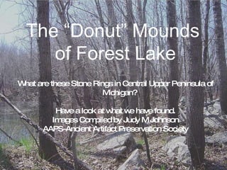
- 1. The “Donut” Mounds of Forest Lake What are these Stone Rings in Central Upper Peninsula of Michigan? Have a look at what we have found. Images Compiled by Judy M Johnson AAPS-Ancient Artifact Preservation Society The “Donut” Mounds of Forest Lake
- 3. The rings are nearly invisible, even in the early spring with no foliage. It’s quite a challenge to find them in full foliage during the summer!
- 4. A friend and his dog standing on the top of the east side of rocks piled around north ring.
- 5. Red willow outlines one of the rings
- 6. Mound in early spring, with water in center. This northern one is about 160 ft. across. In July this ring was dry. At that time we were unable to find the other two in the deep, lush foliage of summer.
- 8. The outer rings reveal large stones of limestone slabs, and granite boulders. This is the northernmost ring.
- 9. The stones are not very visible on the inside of the rings. They are quite visible on the outer edges of the rings. The second, central ring. Might this one be older, as it’s stone ring Is nearly obliterated by leaves and grass? It’s about 130 ft across.
- 10. Center ring assembled from 4 photos, has some water in early spring.
- 11. 3 pieced-together photos of Southern smaller ring, with no water. The outer ring does not have much exposed rock. This one is about 125 ft across.
- 12. The West side of the southernmost smaller ring. This one had no water in it in early spring.
- 13. Standing on the inside edge of south ring. It’s damp and puddly, but walkable .
- 14. Satellite photo Showing roads for driving directions to the mounds
- 19. Left: Rings on Islands in Lake, North of the underwater rings seen in second photo to the lower right.
- 21. There’s another mystery nearby: An earth mound on 23 Road, partially surrounded by stones. It’s about 20-25 ft high and 250 ft wide. 1.4 miles (as the crow flies) to the circle mounds.
- 22. Tree covered mound a couple 100 ft north of 23 Road, Limestone, Michigan. A house is built on the south side today.
- 23. The north end of the waterway is the AuTrain River which flows north into Lake Superior. There is a place about 1/3 of the way south, where the flow divides, and the lower half of the Whitefish River, flows south to Bay de Noc.This is the shortest route from Lk Superior to Lk Michigan
- 24. What were these stone circles used for? * Foundations for lodges for river travelers? * Simple reservoirs for water? * What do you think?
- 25. Research, Photos and Design by Judy M Johnson Skandia, Michigan AAPS/Ancient Artifact Preservation Society www.aaapf.org