

Recommended
More Related Content
What's hot
What's hot (20)
Viewers also liked
Viewers also liked (15)
Similar to Mars1
Similar to Mars1 (20)
Recently uploaded
Recently uploaded (20)
Mars1
- 1. Unit 11 Mars
- 2. Physical Properties Radius: 3400 km Moons: Deimos, Phobos Mass: 6.4 × 10 23 kg Density: 3900 kg/m 3 Length of Day: 24.6 hours
- 3. Orbital Properties Mars’s orbit is fairly eccentric – affects amount of sunlight reaching it Mars can be either in the direction of the Sun ( conjunction ) or not ( opposition )
- 4. Long-Distance Observations of Mars Can see polar ice caps that grow and shrink with the seasons:
- 6. The Surface of Mars Water may now be permafrost under polar ice caps Left: Southern polar cap, mostly carbon dioxide Right: Northern polar cap, mostly water? Both images taken during local summer
- 7. Seasons and Dust Storms
- 8. The Surface of Mars This map shows the main surface features of Mars. There is no evidence for plate tectonics.
- 10. The Surface of Mars Much of northern hemisphere may have been ocean:
- 12. The Surface of Mars Major feature: Tharsis bulge , size of North America and 10 km above surroundings Minimal cratering; youngest surface on Mars
- 15. The Surface of Mars Impact craters less than 5 km across have mostly been eroded away Analysis of craters allows estimation of age of surface Crater on right was made when surface was liquid:
- 16. The Surface of Mars Recently, gullies have been seen that seem to indicate the presence of liquid water; interpretation is still in doubt
- 18. The Surface of Mars Was there running water on Mars? Runoff channels resemble those on Earth. Left: Mars Right: Louisiana
- 19. 10.4 The Surface of Mars No evidence of connected river system; features probably due to flash floods
- 21. The Surface of Mars Much of northern hemisphere may have been ocean:
- 22. The Surface of Mars Viking landers both landed in low-latitude northern plains Rocky surface, red due to iron content Viking 1 :
- 23. The Surface of Mars Viking 2 :
- 24. The Surface of Mars Spirit ’s landing place was similar to the Viking s’; this is a 360 ° panorama :
- 25. The Martian Atmosphere Martian atmosphere is mostly carbon dioxide, and very thin Too thin to retain much heat; temperature drops sharply at night
- 27. The Martian Atmosphere Fog can form in low-lying areas, as sunlight strikes:
- 28. The Martian Atmosphere Mars may be victim of runaway greenhouse effect in the opposite sense of Venus’s: As water ice froze, Mars became more and more reflective and its atmosphere thinner and thinner, freezing more and more water and eventually carbon dioxide as well.
- 30. The Moons of Mars Mars has two tiny moons: Phobos (left, 28 km × 20 km) Deimos (right, 16 km × 10 km) Both probably captured from the asteroid belt
- 32. Life on Mars? Many searches have been done for life on Mars, but none has been found. In 1996, scientists claimed to have found such evidence in an Antarctic meteoroid from Mars, but this is in dispute.
- 45. Earth from Mars
Editor's Notes
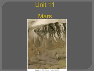
- The search for life on Mars continues unabated. One key ingredient for life anywhere in the universe is probably water, therefore much of the current controversy centers around whether Mars—now drier than any of Earth’s deserts—was ever much wetter than it is today. Here, the Mars Global Surveyor spacecraft took this remarkable image in 2001 of what seems to be extensive layers and gullies of sand and rock near the Mariner valley. This view measures only 1.5 kilometers across and its smallest features are resolved to about 10 meters. The question is: Were those features really caused by flowing water long ago or perhaps by wind action that carved them over eons of time? (NASA)
- The orbit of Mars compared with that of Earth. Observe that Mars’s orbit is noticeably off-center, unlike Earth’s, whose eccentricity is barely perceptible here. When the planets are on opposite sides of the Sun, as at the points marked A, Mars is said to be at conjunction. The planets are at their closest at opposition, when Earth and Mars are aligned and on the same side of the Sun, as at the points marked B. (Note that to get from point A to point B, Earth must travel for nearly 13 months—all the way around its orbit and then some.) (b) Several oppositions of Mars, including the particularly favorable (close) configuration of August 2003 and the unfavorable oppositions of February 1995 and March 1997. The five images of Mars were taken over the course of eight years with the Hubble telescope. (NASA)
- A deep-red (800-nm) image of Mars, taken in 1991 at Pic-du-Midi, an exceptionally clear site in the Pyrenees. One of the planet's polar caps appears at the top. A visible-light Hubble Space Telescope image of Mars, taken while the planet was near opposition in 2003. A view of Mars taken from a Viking spacecraft during its approach in 1976. The planet's surface features can be seen clearly at a level of detail completely invisible from Earth. (Pic-du-Midi Observatory; NASA)
- The southern (a) and northern (b) polar caps of Mars are shown to scale in these mosaics of Mariner 9 images. These are the residual caps, seen here during their respective summers half a Martian year apart. The southern cap is some 350 km across and is made up mostly of frozen carbon dioxide. The northern cap is about 1000 km across and is composed mostly of water ice. The inset shows greater detail in the southern cap. (NASA)
- The Mars Global Surveyor data of Figure 10.4, now displayed as a flat map, with some surface features labeled. Landing sites of several U.S. robot craft are also marked. (NASA)
- Two computer-generated globes of planet Mars, based on detailed measurements made by Mars Global Surveyor . Color represents height above (or below) the mean planetary radius, ranging from dark blue (–8 km) through green, yellow and red (+4 km) to white (over 8 km in altitude), as given on the scale above the images. Frame (a) shows roughly the same hemisphere as that in Figure 10.3, containing the Tharsis region of Mars. Frame (b) shows the planet's other hemisphere, dominated by the giant Hellas impact basin. (NASA)
- An ancient Martian ocean once may have spanned the polar regions. The blue color in this computer-generated map actually indicates depth below the average radius of the planet, but it also outlines quite accurately the extent of the ocean suggested by Mars Global Surveyor data. (The color elevation scale is nearly the same as in Figure 10.4.) (b) This high-resolution image shows tentative evidence for erosion by standing water in the floor of Holden Crater, about 140 km across. (NASA)
- The northern hemisphere of Mars consists of rolling, volcanic plains (false-color image). (b) The southern Martian highlands are heavily cratered (true color). Both photographs show roughly the same scale, nearly 1000 km across. (NASA)
- A mosaic of Mars based on images from a Viking spacecraft in orbit around the planet. Some 5000 km across, the Tharsis region bulges out from Mars's equatorial zone, rising to a height of about 10 km. The large volcanoes on the left mark the approximate peak of the bulge. One of the plains flanking the Tharsis bulge, Chryse Planitia, is toward the right. Dominating the center of the field of view is a vast "canyon" known as Valles Marineris—the Mariner Valley. (NASA)
- The largest volcano known on Mars or anywhere else in the solar system and nearly three times taller than Mount Everest on Earth, this Martian mountain measures about 700 km across its base and 25 km high at its peak. Olympus Mons seems currently inactive and may have been extinct for at least several hundred million years. By comparison, the largest volcano on Earth, Hawaii's Mauna Loa, measures a mere 120 km across and peaks just 9 km above the Pacific Ocean floor. (NASA)
- The large lunar impact crater Copernicus is quite typical of those found on Earth's Moon. Its ejecta blanket appears to be composed of dry, powdery material. The ejecta from Mars's crater Yuty (18 km in diameter) evidently was liquid in nature. This type of crater is sometimes called a "splosh" crater. (NASA)
- This high-resolution Mars Global Surveyor view (left) of a crater wall (right) near the Mariner Valley shows evidence of "gullies" apparently formed by running water in the relatively recent past. If this interpretation is correct, it suggests that liquid water may still reside below the Martian surface. (NASA)
- The Mariner Valley is a huge canyon, 120 km wide and 7 km deep. Its length is about 4000 km, or nearly the full breadth of the continental United States. (b) A close-up view shows the complexity of the valley walls and dry tributaries. (c) A comparison, to scale, with Earth's Grand Canyon, which is a mere 20 km wide and 2 km deep, suggests just how big the Mariner Valley is. (NASA)
- This runoff channel on Mars measures about 400 km long and 5 km wide. (b) The Red River running from Shreveport, Louisiana, to the Mississippi River. The two differ mainly in that there is currently no liquid water in this, or any other, Martian valley. (NASA)
- An outflow channel near the Martian equator bears witness to a catastrophic flood that occurred about 3 billion years ago. (b) The onrushing water that carved out the outflow channels was responsible for forming these oddly shaped "islands" as the flow encountered obstacles—impact craters—in its path. Each "island" is about 40 km long. (NASA)
- Did this fan-shaped region of twisted streams form as a river flowed into a larger sea? If it did, the Mars Global Surveyor image supports the idea that Mars once had large bodies of liquid water on its surface. Not all scientists agree with this interpretation, however. (NASA)
- An ancient Martian ocean once may have spanned the polar regions. The blue color in this computer-generated map actually indicates depth below the average radius of the planet, but it also outlines quite accurately the extent of the ocean suggested by Mars Global Surveyor data. (The color elevation scale is nearly the same as in Figure 10.4.) (b) This high-resolution image shows tentative evidence for erosion by standing water in the floor of Holden Crater, about 140 km across. (NASA)
- This is the view from the Viking 1 spacecraft now parked on the surface of Mars. The fine-grained soil and the rock-strewn terrain stretching toward the horizon are reddish. Containing substantial amounts of iron ore, the surface of Mars is literally rusting away. The sky is a pale pink color, the result of airborne dust. (NASA)
- Another view of the Martian surface, this one rock strewn and flat, as seen through the camera aboard the Viking 2 robot that soft-landed on the northern Utopian plains. The discarded canister is about 20 cm long. The 0.5-m scars in the dirt were made by the robot's shovel. (NASA)
- This 360° panorama was taken by the Mars Exploration Rover lander in 2004. Its golf-cart size vehicle, Spirit , had not yet rolled off its mothership (see also Fig. 6.4). This view is from inside Gusev crater, a relatively smooth depression about 150 km wide and 15° south of the Martian equator; the largest rocks seen are about 20 cm across. (JPL)
- Structure of the Martian atmosphere, as determined by Viking and Mars Global Surveyor . The troposphere, which rises to an altitude of about 30 km in the daytime, occasionally contains clouds of water ice or, more frequently, dust during the planet-wide dust storms that occur each year. Above the troposphere lies the stratosphere. Note the absence of a higher temperature zone in the stratosphere, indicating the absence of an ozone layer.
- As the Sun's light reaches and heats the canyon floor, it drives water vapor from the surface. When this vapor comes in contact with the colder air above the surface, it condenses again, and a temporary water-ice "fog" results, as seen here, near Mars's northern polar cap. (b) Fog also shrouds the floor of the 200-km-wide Lowell Crater, imaged here by Mars Global Surveyor in the autumn of 2000. (NASA)
- Evidence suggests that Mars was wet in its past, with a great northern ocean. Fluctuations in the axial tilt would have made the northern hemisphere warm enough for liquid water. Sedimentary rocks suggest liquid water.