SlideShare a Scribd company logo
1 of 1
Download to read offline
Ground truthing is an important, however tedious, step to assessing the accuracy of landsat data
classifications and other remotely sensing imagery. Conducting fieldwork allows for the researcher to
gather information that is unavailable with remotely sensed imagery. For instance, the 2001 and 2011
National Land Cover Datasets has a resolution that does not allow for smaller features to be seen. This
type of fieldwork requires a lot of time, patience, and a good eye to differentiate land cover types.
Accuracy assessments of the ground truth data indicate that this method of data gathering is fairly
accurate and reliable. The data collection method of ground truthing can be improved with a more
strategic protocol of collection in the field, and perhaps with more time and freedom involving future
research, this method can become even more accurate.
Scope
The scope of this project involved ground truthing various land cover types in Union County, New
Mexico and Cimarron County, Oklahoma. By utilizing public roadways, our task was to ground truth
the region in two separate vehicles and cover as many different topographical landmarks as possible.
Limitations
Access was limited to public roadways. Private property was off limits and all data had to be
collected on the road and required significant amounts of estimation, such as the depth of the land cover
type. In addition, collection had to occur during the day with the additional limitation of the fall season
shortening daylight. The time allotted to acquire such a vast amount of data in the region was limited to
only two days which required quicker and perhaps less accurate methods of collection. This also limited
travel in the larger of the two counties, Union County.
Limitations involving data analysis included the age of the National Land Cover Dataset. We were
conducting an analysis on a classified image that is from 2011. The gap in image age could have skewed
the accuracy assessment results.
Ground Truthing Invasive Species in Cimarron County, OK and Union
County, NM
Anthony Pennington, Austin Fessler, Giovanni Penna, Hayden Harrison, Kayla King, Zach Robinson
Introduction
Background
Methodology
Recently, there has been an influx of invasive species of vegetation such as the Cholla Cactus
(Cylindropuntia imbricata) and Pinyon-Juniper Woodlands (Pinus edulis/Juniperus grandis) in Cimarron
County, Oklahoma and Union County, New Mexico. This study gathered ground truthing points to create a
database for analysis in order to analyze this change. The ground truthing samples were collected via GPS
in order to record land cover across the region. The goal of the study was to identify the spread of invasive
species, mainly woody plant encroachment, and to compare the ground truth points with the 2011 National
Land Cover Dataset. This was mostly looking at the conversion of grasslands into irrigated agricultural
farmland and shrubland. We compared our findings with 2011 National Land Cover Dataset and conducted
an accuracy analysis and a land cover change analysis.
Group of Juniper in Cimarron County, Oklahoma Salt Cedar across the Cimarron River Cimarron
County, Oklahoma
Scattered Cholla in Cimarron County, Oklahoma
Citations
Anadon, J. D., Sala, O., Turner, B. L., & Bennett, E. M. (2014). “Effect of woody-plant encroachment on livestock production in North and South America”. Proceedings of the
National Academy of Sciences of the United States of America, 11(35), pp. 12949
Carpenter, A.T. 1998. “Element Stewardship Abstract for Tamarisk.” The Nature Conservancy Wildland Weed Database.
Eastman, J Ronald. 2015. "TerrSet manual." Accessed in TerrSet version 18:1-390.
Fagin, T., Vadjunec, J., Colston, N., Wenger, K., & Graham, A. (2016) “Land tenure and landscape change: a comparison of public-private lands in the southern High Plains”.
Ecological Processes.
Hargrave, Michael L. 2006. "Ground truthing the results of geophysical surveys." Remote sensing in archaeology: an explicitly North American perspective:269-304.
Story, Michael, and Russell G Congalton. 1986. "Accuracy assessment: a user’s perspective." Photogrammetric Engineering and remote sensing 52 (3):397-399.
Verne, Grant and Karen A. Grant. June 7, 1971. “Natural Hybridization between the Cholla Cactus Species Opuntia spinosior and Opuntia versicolor.” Department of Botany,
University of Texas.
White, John P. Diane Pub Co, 2004. “Ecology, diversity and sustainability of the middle Rio Grande basin.”
Acknowledgements
This student fieldwork experience has been funded in part by a National Science Foundation (NSF) research grant (#CMMI-1266381:
Vadjunec, Phillips, & Fagin). Any opinions and findings are those of the authors and not NSF.
Citations & Acknowledgements
National Land Cover Dataset (simplified) Legend
Deciduous Forest
Ground Truthing Points Across Union County, New Mexico
Results
Ground Truthing Points Across Cimarron County, Oklahoma
Grassland/Herbaceous
Cultivated Crops
Developed
Barren Land
Evergreen Forest
Shrubland
Open Water
Discussion
Cimarron County Accuracy Assessment Results
Conclusions
Classification Percent Accurate Total Percent Accurate
Barren Land 20%
64%
Cultivated Crops 100%
Deciduous Forest 0%
Developed 83%
Evergreen Forest 14%
Grassland/Herbaceous 96%
Open Water 100%
Shrub/Scrub 100%
Scope and Limitations
Classification Percent Accurate Total Percent Accurate
Barren Land 100%
69%
Cultivated Crops 73%
Developed 100%
Evergreen Forest 0%
Grassland/Herbaceous 82%
Open Water 100%
Shrub/Scrub 29%
Union County Accuracy Assessment Results
Land Cover Change Assessment from 2001 to 2011
Center Pivot Irrigation in Union County, New Mexico
The accuracy assessment conducted on the ground truth points recorded in Union County, NM and
Cimarron County, OK reveal a 64% and 69% accuracy rate, respectively. In Union County, land cover
types such as cultivated crops, open water, and shrubland were recorded with 100% accuracy. Other
land cover types, such as developed and grassland/herbaceous areas, were recorded with an accuracy of
83% and 96%, respectively. In Cimarron County, land cover types such as barren land, developed, and
open water were recorded with 100% accuracy. Other land cover types, such as cultivated crops and
grassland/herbaceous areas, were recorded at an accuracy level of 73% and 82%, respectively.
Together, the accuracy assessment revealed a 62% accuracy in the ground truth points recorded between
both counties. In both Cimarron County and Union County, the land cover types of evergreen forests
had an accuracy assessment percentage of 0% and 14%, respectively. This could be due to the age of the
2011 NLCD data as this land cover type looked to be relatively new.
The land cover change assessment from 2001 to 2011 indicated large areas of stable land cover
across both Cimarron County, OK and Union County, NM. The land cover change results show areas of
change from grassland/herbaceous to cultivated crops. Areas in blue show change from
grassland/herbaceous to cultivated crops. Areas that experienced change from grassland/herbaceous to
shrubland can be seen in pink.
Land Cover Change Assessment Legend
Stable Shrubland
Grassland/Herbaceous to
Shrubland
Stable Grassland/
Herbaceous
Other
Stable Cultivated Crops
Grassland/Herbaceous to
Cultivated Crops
An example of Yucca in Union County, New Mexico Clayton Lake, Union County, New Mexico
In Cimarron and Union counties, woody plant encroachment has created a number of issues regarding
the effect of the invasive species in the region. Ground cover is being taken over, pushing out native grass
species and reducing the area these grasses can grow in. We believe overgrazing and pasture conversion of
fields in the region are a primary factor in the encroachment of these invasive species. In comparing the
ground truthing points to the NLCD data for the two counties, we assessed the accuracy of said data as well
as conducted a land cover change analysis.
Cholla Shrubland
Most commonly found in the deserts of North America, the cholla cactus has more than twenty species in
the Optunia genus of the Cactacea family. The flowers have a green to yellowish color which sometimes
can be orange. The species thrives mostly in the months of April through June and are most commonly
located in the deserts of Southwest America with a variety of species inhabiting these deserts. The species
locations are often based on elevation and other vegetation that is present. Cholla species prefer dry soil in
areas that resemble steppes, but some species have adapted to forested areas with most being located in dry
rocky areas.
Pinyon-Juniper Shrubland/Woodland
Pinyon-Juniper woodlands are one of the largest ecosystems in the Southwest and in the Middle Rio
Grande Basin (White 2004). The tree has historically been used as a natural resource. Pinyon-Juniper are
trees that are relatively small and average around five meters in height. The Pinyon-Juniper has different
species compositions. The tree sometimes is composed of dense areas that are relatively large in height,
while other areas have more spread out populations that are shorter in height. In New Mexico alone, there
are hundreds of pinyon species. This type of woodlands suffers from a variety of damaging agents such as
insects and invasive species of plants and trees.
In order to assess the Landsat image accuracy and landscape changes, a mixed methods approach was
used to collect and process the spatial data. Cimarron and Union Counties were investigated using a GPS
data collection of training samples for the purposes of an accuracy assessment and land cover change
analyses. Using that image, along with others, a land cover change analysis was performed to determine
how both Cimarron and Union Counties have changed between the years of 2001 and 2011.
Ground truthing is a process that allows a researcher to verify the classification results of a remotely
sensed image through the use of independent evidence (Hargrave 2006). A Trimble Juno 3B handheld GPS
unit was used to collect training samples in the field. Information collected on the GPS unit included the
researcher’s name, date, time, starting and ending points, latitude and longitude, and the training sample
classification and activity present at each location.
After the data was collected, the training sample points were used to run an accuracy assessment on
the 2011 National Land Cover Dataset. ESRI’s ArcGIS was utilized to compare the points with the
classified raster image. Using the ‘Extract Values to Points’ geoprocessing tool, we were able to compare
the classified points with the classified raster image. Simple statistics were performed on the points to
check for accuracy.
In order to conduct a land cover change analysis, the National Land Cover Datasets for 2001 and 2011
were clipped to our study areas. The raster calculator was used to identify areas of Shrubland,
Grassland/Herbaceous, and Cultivated Crops as well as areas where Grassland/Herbaceous changed to
Shrubland and Cultivated Crops.

More Related Content

What's hot

Barter Final Capstone Presentation
Barter Final Capstone PresentationBarter Final Capstone Presentation
Barter Final Capstone PresentationRebecca Barter
 
Seminário 4 egerton-warburton_et_al-2000-ecological_applications_mycorrhiza (2)
Seminário 4 egerton-warburton_et_al-2000-ecological_applications_mycorrhiza (2)Seminário 4 egerton-warburton_et_al-2000-ecological_applications_mycorrhiza (2)
Seminário 4 egerton-warburton_et_al-2000-ecological_applications_mycorrhiza (2)Carlos Alberto Monteiro
 
Extent of gully erosion and farmer’s perception of soil erosion in alalicha w...
Extent of gully erosion and farmer’s perception of soil erosion in alalicha w...Extent of gully erosion and farmer’s perception of soil erosion in alalicha w...
Extent of gully erosion and farmer’s perception of soil erosion in alalicha w...Alexander Decker
 
Assessing the Impact of Blister Rust Infected Whitebark Pine in the Alpine Tr...
Assessing the Impact of Blister Rust Infected Whitebark Pine in the Alpine Tr...Assessing the Impact of Blister Rust Infected Whitebark Pine in the Alpine Tr...
Assessing the Impact of Blister Rust Infected Whitebark Pine in the Alpine Tr...University of the Highlands and Islands
 
Rate of gully expansion on major land uses, the case of huluka watershed, cen...
Rate of gully expansion on major land uses, the case of huluka watershed, cen...Rate of gully expansion on major land uses, the case of huluka watershed, cen...
Rate of gully expansion on major land uses, the case of huluka watershed, cen...Alexander Decker
 
24th Congress for Conservation Biology, Canada 2010
24th Congress for Conservation Biology, Canada 201024th Congress for Conservation Biology, Canada 2010
24th Congress for Conservation Biology, Canada 2010Dr. Amalesh Dhar
 
Agricultural Drought Severity assessment using land Surface temperature and N...
Agricultural Drought Severity assessment using land Surface temperature and N...Agricultural Drought Severity assessment using land Surface temperature and N...
Agricultural Drought Severity assessment using land Surface temperature and N...John Kapoi Kapoi
 
Checkerspot Butterfly Presentation
Checkerspot Butterfly PresentationCheckerspot Butterfly Presentation
Checkerspot Butterfly PresentationElizabeth
 
Ecology Thesis Proposal: Vegetation on the Selected Areas in Sugbongcogon, Mi...
Ecology Thesis Proposal: Vegetation on the Selected Areas in Sugbongcogon, Mi...Ecology Thesis Proposal: Vegetation on the Selected Areas in Sugbongcogon, Mi...
Ecology Thesis Proposal: Vegetation on the Selected Areas in Sugbongcogon, Mi...Paula Marie Llido
 
Effect of human settlement and altitude on rangeland browse woody species bio...
Effect of human settlement and altitude on rangeland browse woody species bio...Effect of human settlement and altitude on rangeland browse woody species bio...
Effect of human settlement and altitude on rangeland browse woody species bio...Alexander Decker
 
Variability in the Physico-chemical Properties of Soils of Similar Lithology ...
Variability in the Physico-chemical Properties of Soils of Similar Lithology ...Variability in the Physico-chemical Properties of Soils of Similar Lithology ...
Variability in the Physico-chemical Properties of Soils of Similar Lithology ...Journal of Agriculture and Crops
 
Swanson BJ et al 2006 Dem & Genetic Eval of American Marten Reintroduction J ...
Swanson BJ et al 2006 Dem & Genetic Eval of American Marten Reintroduction J ...Swanson BJ et al 2006 Dem & Genetic Eval of American Marten Reintroduction J ...
Swanson BJ et al 2006 Dem & Genetic Eval of American Marten Reintroduction J ...Larry Robert Peters
 

What's hot (20)

Barter Final Capstone Presentation
Barter Final Capstone PresentationBarter Final Capstone Presentation
Barter Final Capstone Presentation
 
Seminário 4 egerton-warburton_et_al-2000-ecological_applications_mycorrhiza (2)
Seminário 4 egerton-warburton_et_al-2000-ecological_applications_mycorrhiza (2)Seminário 4 egerton-warburton_et_al-2000-ecological_applications_mycorrhiza (2)
Seminário 4 egerton-warburton_et_al-2000-ecological_applications_mycorrhiza (2)
 
8247 pdf
8247 pdf8247 pdf
8247 pdf
 
FW Biology Publication Final
FW Biology Publication FinalFW Biology Publication Final
FW Biology Publication Final
 
Restoration, Reconciliation, and Reconnecting with Nature Nearby
Restoration, Reconciliation, and Reconnecting with Nature NearbyRestoration, Reconciliation, and Reconnecting with Nature Nearby
Restoration, Reconciliation, and Reconnecting with Nature Nearby
 
PRESENTATION
PRESENTATIONPRESENTATION
PRESENTATION
 
Extent of gully erosion and farmer’s perception of soil erosion in alalicha w...
Extent of gully erosion and farmer’s perception of soil erosion in alalicha w...Extent of gully erosion and farmer’s perception of soil erosion in alalicha w...
Extent of gully erosion and farmer’s perception of soil erosion in alalicha w...
 
BPJ11-09_Wolfe_et_al
BPJ11-09_Wolfe_et_alBPJ11-09_Wolfe_et_al
BPJ11-09_Wolfe_et_al
 
Assessing the Impact of Blister Rust Infected Whitebark Pine in the Alpine Tr...
Assessing the Impact of Blister Rust Infected Whitebark Pine in the Alpine Tr...Assessing the Impact of Blister Rust Infected Whitebark Pine in the Alpine Tr...
Assessing the Impact of Blister Rust Infected Whitebark Pine in the Alpine Tr...
 
salisu
salisusalisu
salisu
 
Rate of gully expansion on major land uses, the case of huluka watershed, cen...
Rate of gully expansion on major land uses, the case of huluka watershed, cen...Rate of gully expansion on major land uses, the case of huluka watershed, cen...
Rate of gully expansion on major land uses, the case of huluka watershed, cen...
 
24th Congress for Conservation Biology, Canada 2010
24th Congress for Conservation Biology, Canada 201024th Congress for Conservation Biology, Canada 2010
24th Congress for Conservation Biology, Canada 2010
 
Agricultural Drought Severity assessment using land Surface temperature and N...
Agricultural Drought Severity assessment using land Surface temperature and N...Agricultural Drought Severity assessment using land Surface temperature and N...
Agricultural Drought Severity assessment using land Surface temperature and N...
 
samanthaposter
samanthapostersamanthaposter
samanthaposter
 
bgsu1349900740
bgsu1349900740bgsu1349900740
bgsu1349900740
 
Checkerspot Butterfly Presentation
Checkerspot Butterfly PresentationCheckerspot Butterfly Presentation
Checkerspot Butterfly Presentation
 
Ecology Thesis Proposal: Vegetation on the Selected Areas in Sugbongcogon, Mi...
Ecology Thesis Proposal: Vegetation on the Selected Areas in Sugbongcogon, Mi...Ecology Thesis Proposal: Vegetation on the Selected Areas in Sugbongcogon, Mi...
Ecology Thesis Proposal: Vegetation on the Selected Areas in Sugbongcogon, Mi...
 
Effect of human settlement and altitude on rangeland browse woody species bio...
Effect of human settlement and altitude on rangeland browse woody species bio...Effect of human settlement and altitude on rangeland browse woody species bio...
Effect of human settlement and altitude on rangeland browse woody species bio...
 
Variability in the Physico-chemical Properties of Soils of Similar Lithology ...
Variability in the Physico-chemical Properties of Soils of Similar Lithology ...Variability in the Physico-chemical Properties of Soils of Similar Lithology ...
Variability in the Physico-chemical Properties of Soils of Similar Lithology ...
 
Swanson BJ et al 2006 Dem & Genetic Eval of American Marten Reintroduction J ...
Swanson BJ et al 2006 Dem & Genetic Eval of American Marten Reintroduction J ...Swanson BJ et al 2006 Dem & Genetic Eval of American Marten Reintroduction J ...
Swanson BJ et al 2006 Dem & Genetic Eval of American Marten Reintroduction J ...
 

Similar to Ground Truthing Invasive Species in Cimarron County, OK and Union County, NM

Agro ecological assessment of soil quality of a river watershed in the niger ...
Agro ecological assessment of soil quality of a river watershed in the niger ...Agro ecological assessment of soil quality of a river watershed in the niger ...
Agro ecological assessment of soil quality of a river watershed in the niger ...Alexander Decker
 
Paper - Landscape Change Over 60 Years Surrounding Cedarburg Bog
Paper - Landscape Change Over 60 Years Surrounding Cedarburg BogPaper - Landscape Change Over 60 Years Surrounding Cedarburg Bog
Paper - Landscape Change Over 60 Years Surrounding Cedarburg BogJason Schroeder
 
Shrinkage and carbon stock in wetlands of fogera plain, north west ethiopia
Shrinkage and carbon stock in wetlands of fogera plain, north west ethiopiaShrinkage and carbon stock in wetlands of fogera plain, north west ethiopia
Shrinkage and carbon stock in wetlands of fogera plain, north west ethiopiaAlexander Decker
 
Effect of changing landuse
Effect of changing landuseEffect of changing landuse
Effect of changing landuseAlexander Decker
 
Identifying Coastal Forest Merlin (Falco columbarius suckleyi) Breeding Habit...
Identifying Coastal Forest Merlin (Falco columbarius suckleyi) Breeding Habit...Identifying Coastal Forest Merlin (Falco columbarius suckleyi) Breeding Habit...
Identifying Coastal Forest Merlin (Falco columbarius suckleyi) Breeding Habit...Christopher Talley
 
Land use cover dynamics in ribb watershed, north western ethiopia
Land use cover dynamics in ribb watershed, north western ethiopiaLand use cover dynamics in ribb watershed, north western ethiopia
Land use cover dynamics in ribb watershed, north western ethiopiaAlexander Decker
 
The North America and Eurasia Arctic transects:
The North America and Eurasia Arctic transects: The North America and Eurasia Arctic transects:
The North America and Eurasia Arctic transects: Edie Barbour
 
Evs2011 talk two_transects20110404(3)
Evs2011 talk two_transects20110404(3)Evs2011 talk two_transects20110404(3)
Evs2011 talk two_transects20110404(3)Edie Barbour
 
Effect of land use and land cover change on some soil chemical and physical p...
Effect of land use and land cover change on some soil chemical and physical p...Effect of land use and land cover change on some soil chemical and physical p...
Effect of land use and land cover change on some soil chemical and physical p...Alexander Decker
 
Assessing soil nutrient depletion to household food insecurity in the smallho...
Assessing soil nutrient depletion to household food insecurity in the smallho...Assessing soil nutrient depletion to household food insecurity in the smallho...
Assessing soil nutrient depletion to household food insecurity in the smallho...Alexander Decker
 
Response of-central-california-oak-woodlands-to-extreme-drought-2157-7617-100...
Response of-central-california-oak-woodlands-to-extreme-drought-2157-7617-100...Response of-central-california-oak-woodlands-to-extreme-drought-2157-7617-100...
Response of-central-california-oak-woodlands-to-extreme-drought-2157-7617-100...science journals
 
DJW Poster Symposium 2016 Complete
DJW Poster Symposium 2016 CompleteDJW Poster Symposium 2016 Complete
DJW Poster Symposium 2016 CompleteDanny Wilson
 
JesseMiller_MalcolmNichols_FireAndLULCResearchPaper.docx
JesseMiller_MalcolmNichols_FireAndLULCResearchPaper.docxJesseMiller_MalcolmNichols_FireAndLULCResearchPaper.docx
JesseMiller_MalcolmNichols_FireAndLULCResearchPaper.docxMalcolm Nichols
 

Similar to Ground Truthing Invasive Species in Cimarron County, OK and Union County, NM (20)

Agro ecological assessment of soil quality of a river watershed in the niger ...
Agro ecological assessment of soil quality of a river watershed in the niger ...Agro ecological assessment of soil quality of a river watershed in the niger ...
Agro ecological assessment of soil quality of a river watershed in the niger ...
 
Paper - Landscape Change Over 60 Years Surrounding Cedarburg Bog
Paper - Landscape Change Over 60 Years Surrounding Cedarburg BogPaper - Landscape Change Over 60 Years Surrounding Cedarburg Bog
Paper - Landscape Change Over 60 Years Surrounding Cedarburg Bog
 
Shrinkage and carbon stock in wetlands of fogera plain, north west ethiopia
Shrinkage and carbon stock in wetlands of fogera plain, north west ethiopiaShrinkage and carbon stock in wetlands of fogera plain, north west ethiopia
Shrinkage and carbon stock in wetlands of fogera plain, north west ethiopia
 
Effect of changing landuse
Effect of changing landuseEffect of changing landuse
Effect of changing landuse
 
Identifying Coastal Forest Merlin (Falco columbarius suckleyi) Breeding Habit...
Identifying Coastal Forest Merlin (Falco columbarius suckleyi) Breeding Habit...Identifying Coastal Forest Merlin (Falco columbarius suckleyi) Breeding Habit...
Identifying Coastal Forest Merlin (Falco columbarius suckleyi) Breeding Habit...
 
Land use cover dynamics in ribb watershed, north western ethiopia
Land use cover dynamics in ribb watershed, north western ethiopiaLand use cover dynamics in ribb watershed, north western ethiopia
Land use cover dynamics in ribb watershed, north western ethiopia
 
The North America and Eurasia Arctic transects:
The North America and Eurasia Arctic transects: The North America and Eurasia Arctic transects:
The North America and Eurasia Arctic transects:
 
Evs2011 talk two_transects20110404(3)
Evs2011 talk two_transects20110404(3)Evs2011 talk two_transects20110404(3)
Evs2011 talk two_transects20110404(3)
 
Inventory and monitoring of tree resources in agroecosystems
Inventory and monitoring of tree resources in agroecosystemsInventory and monitoring of tree resources in agroecosystems
Inventory and monitoring of tree resources in agroecosystems
 
Effect of land use and land cover change on some soil chemical and physical p...
Effect of land use and land cover change on some soil chemical and physical p...Effect of land use and land cover change on some soil chemical and physical p...
Effect of land use and land cover change on some soil chemical and physical p...
 
Webb et al 1978
Webb et al 1978Webb et al 1978
Webb et al 1978
 
poster version 2
poster version 2poster version 2
poster version 2
 
Assessing soil nutrient depletion to household food insecurity in the smallho...
Assessing soil nutrient depletion to household food insecurity in the smallho...Assessing soil nutrient depletion to household food insecurity in the smallho...
Assessing soil nutrient depletion to household food insecurity in the smallho...
 
Dust mitigation on the colorado plateau
Dust mitigation on the colorado plateauDust mitigation on the colorado plateau
Dust mitigation on the colorado plateau
 
Response of-central-california-oak-woodlands-to-extreme-drought-2157-7617-100...
Response of-central-california-oak-woodlands-to-extreme-drought-2157-7617-100...Response of-central-california-oak-woodlands-to-extreme-drought-2157-7617-100...
Response of-central-california-oak-woodlands-to-extreme-drought-2157-7617-100...
 
Bio Slide show
Bio Slide showBio Slide show
Bio Slide show
 
Poster Template 24x18
Poster Template 24x18Poster Template 24x18
Poster Template 24x18
 
DJW Poster Symposium 2016 Complete
DJW Poster Symposium 2016 CompleteDJW Poster Symposium 2016 Complete
DJW Poster Symposium 2016 Complete
 
JesseMiller_MalcolmNichols_FireAndLULCResearchPaper.docx
JesseMiller_MalcolmNichols_FireAndLULCResearchPaper.docxJesseMiller_MalcolmNichols_FireAndLULCResearchPaper.docx
JesseMiller_MalcolmNichols_FireAndLULCResearchPaper.docx
 
Effects of Land Use on Soil Physical and Chemical Properties in Akokwa Area o...
Effects of Land Use on Soil Physical and Chemical Properties in Akokwa Area o...Effects of Land Use on Soil Physical and Chemical Properties in Akokwa Area o...
Effects of Land Use on Soil Physical and Chemical Properties in Akokwa Area o...
 

Recently uploaded

Basic Civil Engineering first year Notes- Chapter 4 Building.pptx
Basic Civil Engineering first year Notes- Chapter 4 Building.pptxBasic Civil Engineering first year Notes- Chapter 4 Building.pptx
Basic Civil Engineering first year Notes- Chapter 4 Building.pptxDenish Jangid
 
Activity 01 - Artificial Culture (1).pdf
Activity 01 - Artificial Culture (1).pdfActivity 01 - Artificial Culture (1).pdf
Activity 01 - Artificial Culture (1).pdfciinovamais
 
How to Manage Global Discount in Odoo 17 POS
How to Manage Global Discount in Odoo 17 POSHow to Manage Global Discount in Odoo 17 POS
How to Manage Global Discount in Odoo 17 POSCeline George
 
Mixin Classes in Odoo 17 How to Extend Models Using Mixin Classes
Mixin Classes in Odoo 17  How to Extend Models Using Mixin ClassesMixin Classes in Odoo 17  How to Extend Models Using Mixin Classes
Mixin Classes in Odoo 17 How to Extend Models Using Mixin ClassesCeline George
 
Google Gemini An AI Revolution in Education.pptx
Google Gemini An AI Revolution in Education.pptxGoogle Gemini An AI Revolution in Education.pptx
Google Gemini An AI Revolution in Education.pptxDr. Sarita Anand
 
ComPTIA Overview | Comptia Security+ Book SY0-701
ComPTIA Overview | Comptia Security+ Book SY0-701ComPTIA Overview | Comptia Security+ Book SY0-701
ComPTIA Overview | Comptia Security+ Book SY0-701bronxfugly43
 
Key note speaker Neum_Admir Softic_ENG.pdf
Key note speaker Neum_Admir Softic_ENG.pdfKey note speaker Neum_Admir Softic_ENG.pdf
Key note speaker Neum_Admir Softic_ENG.pdfAdmir Softic
 
1029-Danh muc Sach Giao Khoa khoi 6.pdf
1029-Danh muc Sach Giao Khoa khoi  6.pdf1029-Danh muc Sach Giao Khoa khoi  6.pdf
1029-Danh muc Sach Giao Khoa khoi 6.pdfQucHHunhnh
 
Spellings Wk 3 English CAPS CARES Please Practise
Spellings Wk 3 English CAPS CARES Please PractiseSpellings Wk 3 English CAPS CARES Please Practise
Spellings Wk 3 English CAPS CARES Please PractiseAnaAcapella
 
SOC 101 Demonstration of Learning Presentation
SOC 101 Demonstration of Learning PresentationSOC 101 Demonstration of Learning Presentation
SOC 101 Demonstration of Learning Presentationcamerronhm
 
Making communications land - Are they received and understood as intended? we...
Making communications land - Are they received and understood as intended? we...Making communications land - Are they received and understood as intended? we...
Making communications land - Are they received and understood as intended? we...Association for Project Management
 
Dyslexia AI Workshop for Slideshare.pptx
Dyslexia AI Workshop for Slideshare.pptxDyslexia AI Workshop for Slideshare.pptx
Dyslexia AI Workshop for Slideshare.pptxcallscotland1987
 
Application orientated numerical on hev.ppt
Application orientated numerical on hev.pptApplication orientated numerical on hev.ppt
Application orientated numerical on hev.pptRamjanShidvankar
 
Unit-IV; Professional Sales Representative (PSR).pptx
Unit-IV; Professional Sales Representative (PSR).pptxUnit-IV; Professional Sales Representative (PSR).pptx
Unit-IV; Professional Sales Representative (PSR).pptxVishalSingh1417
 
Jual Obat Aborsi Hongkong ( Asli No.1 ) 085657271886 Obat Penggugur Kandungan...
Jual Obat Aborsi Hongkong ( Asli No.1 ) 085657271886 Obat Penggugur Kandungan...Jual Obat Aborsi Hongkong ( Asli No.1 ) 085657271886 Obat Penggugur Kandungan...
Jual Obat Aborsi Hongkong ( Asli No.1 ) 085657271886 Obat Penggugur Kandungan...ZurliaSoop
 
Sociology 101 Demonstration of Learning Exhibit
Sociology 101 Demonstration of Learning ExhibitSociology 101 Demonstration of Learning Exhibit
Sociology 101 Demonstration of Learning Exhibitjbellavia9
 
ICT Role in 21st Century Education & its Challenges.pptx
ICT Role in 21st Century Education & its Challenges.pptxICT Role in 21st Century Education & its Challenges.pptx
ICT Role in 21st Century Education & its Challenges.pptxAreebaZafar22
 
How to Create and Manage Wizard in Odoo 17
How to Create and Manage Wizard in Odoo 17How to Create and Manage Wizard in Odoo 17
How to Create and Manage Wizard in Odoo 17Celine George
 
FSB Advising Checklist - Orientation 2024
FSB Advising Checklist - Orientation 2024FSB Advising Checklist - Orientation 2024
FSB Advising Checklist - Orientation 2024Elizabeth Walsh
 

Recently uploaded (20)

Basic Civil Engineering first year Notes- Chapter 4 Building.pptx
Basic Civil Engineering first year Notes- Chapter 4 Building.pptxBasic Civil Engineering first year Notes- Chapter 4 Building.pptx
Basic Civil Engineering first year Notes- Chapter 4 Building.pptx
 
Activity 01 - Artificial Culture (1).pdf
Activity 01 - Artificial Culture (1).pdfActivity 01 - Artificial Culture (1).pdf
Activity 01 - Artificial Culture (1).pdf
 
How to Manage Global Discount in Odoo 17 POS
How to Manage Global Discount in Odoo 17 POSHow to Manage Global Discount in Odoo 17 POS
How to Manage Global Discount in Odoo 17 POS
 
Mixin Classes in Odoo 17 How to Extend Models Using Mixin Classes
Mixin Classes in Odoo 17  How to Extend Models Using Mixin ClassesMixin Classes in Odoo 17  How to Extend Models Using Mixin Classes
Mixin Classes in Odoo 17 How to Extend Models Using Mixin Classes
 
Google Gemini An AI Revolution in Education.pptx
Google Gemini An AI Revolution in Education.pptxGoogle Gemini An AI Revolution in Education.pptx
Google Gemini An AI Revolution in Education.pptx
 
ComPTIA Overview | Comptia Security+ Book SY0-701
ComPTIA Overview | Comptia Security+ Book SY0-701ComPTIA Overview | Comptia Security+ Book SY0-701
ComPTIA Overview | Comptia Security+ Book SY0-701
 
Key note speaker Neum_Admir Softic_ENG.pdf
Key note speaker Neum_Admir Softic_ENG.pdfKey note speaker Neum_Admir Softic_ENG.pdf
Key note speaker Neum_Admir Softic_ENG.pdf
 
1029-Danh muc Sach Giao Khoa khoi 6.pdf
1029-Danh muc Sach Giao Khoa khoi  6.pdf1029-Danh muc Sach Giao Khoa khoi  6.pdf
1029-Danh muc Sach Giao Khoa khoi 6.pdf
 
Spellings Wk 3 English CAPS CARES Please Practise
Spellings Wk 3 English CAPS CARES Please PractiseSpellings Wk 3 English CAPS CARES Please Practise
Spellings Wk 3 English CAPS CARES Please Practise
 
SOC 101 Demonstration of Learning Presentation
SOC 101 Demonstration of Learning PresentationSOC 101 Demonstration of Learning Presentation
SOC 101 Demonstration of Learning Presentation
 
Making communications land - Are they received and understood as intended? we...
Making communications land - Are they received and understood as intended? we...Making communications land - Are they received and understood as intended? we...
Making communications land - Are they received and understood as intended? we...
 
Dyslexia AI Workshop for Slideshare.pptx
Dyslexia AI Workshop for Slideshare.pptxDyslexia AI Workshop for Slideshare.pptx
Dyslexia AI Workshop for Slideshare.pptx
 
Application orientated numerical on hev.ppt
Application orientated numerical on hev.pptApplication orientated numerical on hev.ppt
Application orientated numerical on hev.ppt
 
Unit-IV; Professional Sales Representative (PSR).pptx
Unit-IV; Professional Sales Representative (PSR).pptxUnit-IV; Professional Sales Representative (PSR).pptx
Unit-IV; Professional Sales Representative (PSR).pptx
 
Jual Obat Aborsi Hongkong ( Asli No.1 ) 085657271886 Obat Penggugur Kandungan...
Jual Obat Aborsi Hongkong ( Asli No.1 ) 085657271886 Obat Penggugur Kandungan...Jual Obat Aborsi Hongkong ( Asli No.1 ) 085657271886 Obat Penggugur Kandungan...
Jual Obat Aborsi Hongkong ( Asli No.1 ) 085657271886 Obat Penggugur Kandungan...
 
Mehran University Newsletter Vol-X, Issue-I, 2024
Mehran University Newsletter Vol-X, Issue-I, 2024Mehran University Newsletter Vol-X, Issue-I, 2024
Mehran University Newsletter Vol-X, Issue-I, 2024
 
Sociology 101 Demonstration of Learning Exhibit
Sociology 101 Demonstration of Learning ExhibitSociology 101 Demonstration of Learning Exhibit
Sociology 101 Demonstration of Learning Exhibit
 
ICT Role in 21st Century Education & its Challenges.pptx
ICT Role in 21st Century Education & its Challenges.pptxICT Role in 21st Century Education & its Challenges.pptx
ICT Role in 21st Century Education & its Challenges.pptx
 
How to Create and Manage Wizard in Odoo 17
How to Create and Manage Wizard in Odoo 17How to Create and Manage Wizard in Odoo 17
How to Create and Manage Wizard in Odoo 17
 
FSB Advising Checklist - Orientation 2024
FSB Advising Checklist - Orientation 2024FSB Advising Checklist - Orientation 2024
FSB Advising Checklist - Orientation 2024
 

Ground Truthing Invasive Species in Cimarron County, OK and Union County, NM

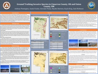
  • 1. Ground truthing is an important, however tedious, step to assessing the accuracy of landsat data classifications and other remotely sensing imagery. Conducting fieldwork allows for the researcher to gather information that is unavailable with remotely sensed imagery. For instance, the 2001 and 2011 National Land Cover Datasets has a resolution that does not allow for smaller features to be seen. This type of fieldwork requires a lot of time, patience, and a good eye to differentiate land cover types. Accuracy assessments of the ground truth data indicate that this method of data gathering is fairly accurate and reliable. The data collection method of ground truthing can be improved with a more strategic protocol of collection in the field, and perhaps with more time and freedom involving future research, this method can become even more accurate. Scope The scope of this project involved ground truthing various land cover types in Union County, New Mexico and Cimarron County, Oklahoma. By utilizing public roadways, our task was to ground truth the region in two separate vehicles and cover as many different topographical landmarks as possible. Limitations Access was limited to public roadways. Private property was off limits and all data had to be collected on the road and required significant amounts of estimation, such as the depth of the land cover type. In addition, collection had to occur during the day with the additional limitation of the fall season shortening daylight. The time allotted to acquire such a vast amount of data in the region was limited to only two days which required quicker and perhaps less accurate methods of collection. This also limited travel in the larger of the two counties, Union County. Limitations involving data analysis included the age of the National Land Cover Dataset. We were conducting an analysis on a classified image that is from 2011. The gap in image age could have skewed the accuracy assessment results. Ground Truthing Invasive Species in Cimarron County, OK and Union County, NM Anthony Pennington, Austin Fessler, Giovanni Penna, Hayden Harrison, Kayla King, Zach Robinson Introduction Background Methodology Recently, there has been an influx of invasive species of vegetation such as the Cholla Cactus (Cylindropuntia imbricata) and Pinyon-Juniper Woodlands (Pinus edulis/Juniperus grandis) in Cimarron County, Oklahoma and Union County, New Mexico. This study gathered ground truthing points to create a database for analysis in order to analyze this change. The ground truthing samples were collected via GPS in order to record land cover across the region. The goal of the study was to identify the spread of invasive species, mainly woody plant encroachment, and to compare the ground truth points with the 2011 National Land Cover Dataset. This was mostly looking at the conversion of grasslands into irrigated agricultural farmland and shrubland. We compared our findings with 2011 National Land Cover Dataset and conducted an accuracy analysis and a land cover change analysis. Group of Juniper in Cimarron County, Oklahoma Salt Cedar across the Cimarron River Cimarron County, Oklahoma Scattered Cholla in Cimarron County, Oklahoma Citations Anadon, J. D., Sala, O., Turner, B. L., & Bennett, E. M. (2014). “Effect of woody-plant encroachment on livestock production in North and South America”. Proceedings of the National Academy of Sciences of the United States of America, 11(35), pp. 12949 Carpenter, A.T. 1998. “Element Stewardship Abstract for Tamarisk.” The Nature Conservancy Wildland Weed Database. Eastman, J Ronald. 2015. "TerrSet manual." Accessed in TerrSet version 18:1-390. Fagin, T., Vadjunec, J., Colston, N., Wenger, K., & Graham, A. (2016) “Land tenure and landscape change: a comparison of public-private lands in the southern High Plains”. Ecological Processes. Hargrave, Michael L. 2006. "Ground truthing the results of geophysical surveys." Remote sensing in archaeology: an explicitly North American perspective:269-304. Story, Michael, and Russell G Congalton. 1986. "Accuracy assessment: a user’s perspective." Photogrammetric Engineering and remote sensing 52 (3):397-399. Verne, Grant and Karen A. Grant. June 7, 1971. “Natural Hybridization between the Cholla Cactus Species Opuntia spinosior and Opuntia versicolor.” Department of Botany, University of Texas. White, John P. Diane Pub Co, 2004. “Ecology, diversity and sustainability of the middle Rio Grande basin.” Acknowledgements This student fieldwork experience has been funded in part by a National Science Foundation (NSF) research grant (#CMMI-1266381: Vadjunec, Phillips, & Fagin). Any opinions and findings are those of the authors and not NSF. Citations & Acknowledgements National Land Cover Dataset (simplified) Legend Deciduous Forest Ground Truthing Points Across Union County, New Mexico Results Ground Truthing Points Across Cimarron County, Oklahoma Grassland/Herbaceous Cultivated Crops Developed Barren Land Evergreen Forest Shrubland Open Water Discussion Cimarron County Accuracy Assessment Results Conclusions Classification Percent Accurate Total Percent Accurate Barren Land 20% 64% Cultivated Crops 100% Deciduous Forest 0% Developed 83% Evergreen Forest 14% Grassland/Herbaceous 96% Open Water 100% Shrub/Scrub 100% Scope and Limitations Classification Percent Accurate Total Percent Accurate Barren Land 100% 69% Cultivated Crops 73% Developed 100% Evergreen Forest 0% Grassland/Herbaceous 82% Open Water 100% Shrub/Scrub 29% Union County Accuracy Assessment Results Land Cover Change Assessment from 2001 to 2011 Center Pivot Irrigation in Union County, New Mexico The accuracy assessment conducted on the ground truth points recorded in Union County, NM and Cimarron County, OK reveal a 64% and 69% accuracy rate, respectively. In Union County, land cover types such as cultivated crops, open water, and shrubland were recorded with 100% accuracy. Other land cover types, such as developed and grassland/herbaceous areas, were recorded with an accuracy of 83% and 96%, respectively. In Cimarron County, land cover types such as barren land, developed, and open water were recorded with 100% accuracy. Other land cover types, such as cultivated crops and grassland/herbaceous areas, were recorded at an accuracy level of 73% and 82%, respectively. Together, the accuracy assessment revealed a 62% accuracy in the ground truth points recorded between both counties. In both Cimarron County and Union County, the land cover types of evergreen forests had an accuracy assessment percentage of 0% and 14%, respectively. This could be due to the age of the 2011 NLCD data as this land cover type looked to be relatively new. The land cover change assessment from 2001 to 2011 indicated large areas of stable land cover across both Cimarron County, OK and Union County, NM. The land cover change results show areas of change from grassland/herbaceous to cultivated crops. Areas in blue show change from grassland/herbaceous to cultivated crops. Areas that experienced change from grassland/herbaceous to shrubland can be seen in pink. Land Cover Change Assessment Legend Stable Shrubland Grassland/Herbaceous to Shrubland Stable Grassland/ Herbaceous Other Stable Cultivated Crops Grassland/Herbaceous to Cultivated Crops An example of Yucca in Union County, New Mexico Clayton Lake, Union County, New Mexico In Cimarron and Union counties, woody plant encroachment has created a number of issues regarding the effect of the invasive species in the region. Ground cover is being taken over, pushing out native grass species and reducing the area these grasses can grow in. We believe overgrazing and pasture conversion of fields in the region are a primary factor in the encroachment of these invasive species. In comparing the ground truthing points to the NLCD data for the two counties, we assessed the accuracy of said data as well as conducted a land cover change analysis. Cholla Shrubland Most commonly found in the deserts of North America, the cholla cactus has more than twenty species in the Optunia genus of the Cactacea family. The flowers have a green to yellowish color which sometimes can be orange. The species thrives mostly in the months of April through June and are most commonly located in the deserts of Southwest America with a variety of species inhabiting these deserts. The species locations are often based on elevation and other vegetation that is present. Cholla species prefer dry soil in areas that resemble steppes, but some species have adapted to forested areas with most being located in dry rocky areas. Pinyon-Juniper Shrubland/Woodland Pinyon-Juniper woodlands are one of the largest ecosystems in the Southwest and in the Middle Rio Grande Basin (White 2004). The tree has historically been used as a natural resource. Pinyon-Juniper are trees that are relatively small and average around five meters in height. The Pinyon-Juniper has different species compositions. The tree sometimes is composed of dense areas that are relatively large in height, while other areas have more spread out populations that are shorter in height. In New Mexico alone, there are hundreds of pinyon species. This type of woodlands suffers from a variety of damaging agents such as insects and invasive species of plants and trees. In order to assess the Landsat image accuracy and landscape changes, a mixed methods approach was used to collect and process the spatial data. Cimarron and Union Counties were investigated using a GPS data collection of training samples for the purposes of an accuracy assessment and land cover change analyses. Using that image, along with others, a land cover change analysis was performed to determine how both Cimarron and Union Counties have changed between the years of 2001 and 2011. Ground truthing is a process that allows a researcher to verify the classification results of a remotely sensed image through the use of independent evidence (Hargrave 2006). A Trimble Juno 3B handheld GPS unit was used to collect training samples in the field. Information collected on the GPS unit included the researcher’s name, date, time, starting and ending points, latitude and longitude, and the training sample classification and activity present at each location. After the data was collected, the training sample points were used to run an accuracy assessment on the 2011 National Land Cover Dataset. ESRI’s ArcGIS was utilized to compare the points with the classified raster image. Using the ‘Extract Values to Points’ geoprocessing tool, we were able to compare the classified points with the classified raster image. Simple statistics were performed on the points to check for accuracy. In order to conduct a land cover change analysis, the National Land Cover Datasets for 2001 and 2011 were clipped to our study areas. The raster calculator was used to identify areas of Shrubland, Grassland/Herbaceous, and Cultivated Crops as well as areas where Grassland/Herbaceous changed to Shrubland and Cultivated Crops.